Tweeting the High Line Life: A Social Media Lens on Urban Green Spaces

Abstract
:1. Introduction
2. Social Media
2.1. Defining Social Media
2.2. Social Media Analytics
2.3. Related Studies
3. Methods
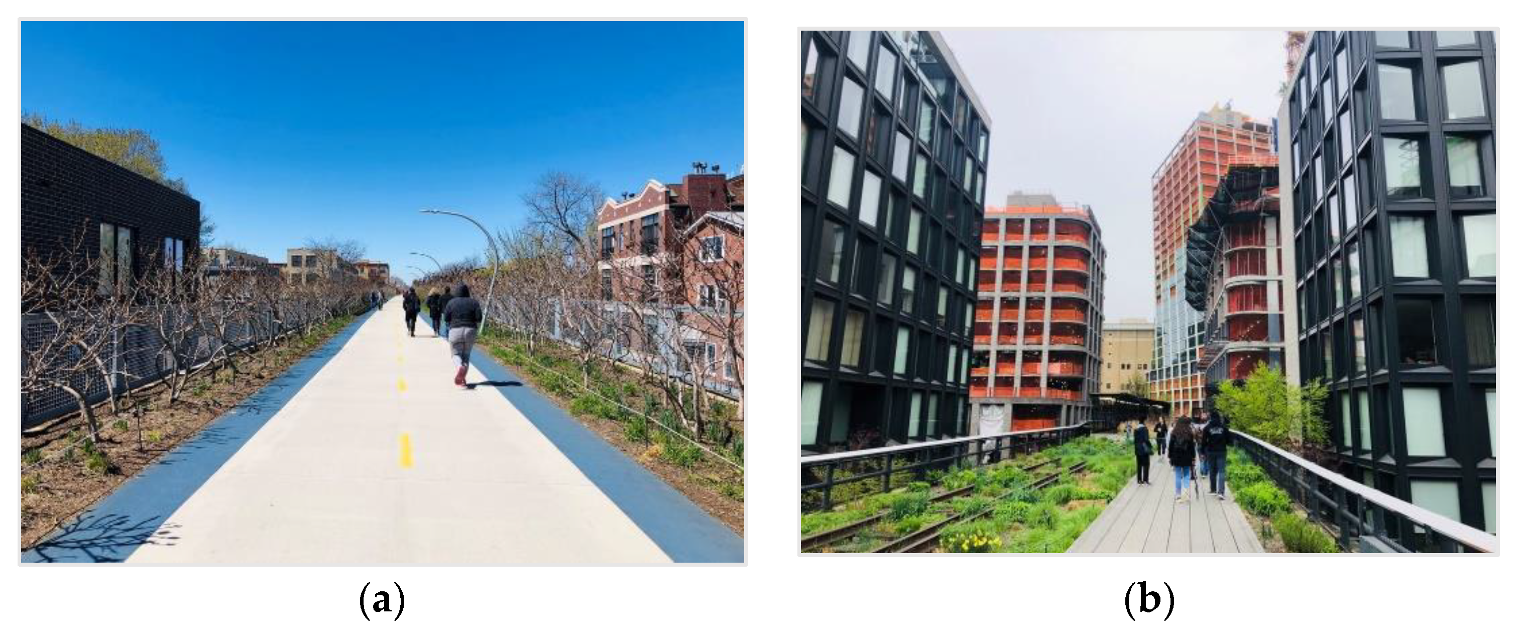
3.1. Study Sites
3.2. Data Collection
3.3. Data Analytics
4. Results
4.1. Public Attitudes about the Elevated Park
4.1.1. The 606
4.1.2. The High Line
4.2. Visitors’ Activities and Satisfaction
5. Discussion
5.1. What do People Use Elevated Parks for?
5.2. What are People’s Opinions about Elevated Parks?
6. Conclusions
Author Contributions
Funding
Conflicts of Interest
References
- Frias-Martinez, V.; Frias-Martinez, E. Spectral clustering for sensing urban land use using Twitter activity. Eng. Appl. Artif. Intell. 2014, 35, 237–245. [Google Scholar] [CrossRef] [Green Version]
- Kelley, M.J. The emergent urban imaginaries of geosocial media. GeoJournal 2013, 78, 181–203. [Google Scholar] [CrossRef]
- Lee, R.; Wakamiya, S.; Sumiya, K. Urban area characterization based on crowd behavioral lifelogs over Twitter. Pers. Ubiquitous Comput. 2013, 17, 605–620. [Google Scholar] [CrossRef]
- Afzalan, N.; Muller, B. The Role of Social Media in Green Infrastructure Planning: A Case Study of Neighborhood Participation in Park Siting. J. Urban. Technol. 2014, 21, 67–83. [Google Scholar] [CrossRef]
- Georgiou, T. Understanding the Real World through the Analysis of User Behavior and Topics in Online Social Media. Ph.D. Thesis, University of California, Santa Barbara, CA, USA, 2017. [Google Scholar]
- Hollander, J.B.; Shen, Y. Using Social Media Data to Infer Urban Attitudes about Bicycling: An Exploratory Case Study of Washington DC. In City Networks; Springer: Cham, Switzerland, 2017; pp. 79–97. [Google Scholar]
- Kankanhalli, A.; Tan, B.C.; Wei, K.-K. Contributing knowledge to electronic knowledge repositories: An empirical investigation. Mis Q. 2005, 29, 113–143. [Google Scholar] [CrossRef] [Green Version]
- Martí, P.; Serrano-Estrada, L.; Nolasco-Cirugeda, A. Using locative social media and urban cartographies to identify and locate successful urban plazas. Cities 2017, 64, 66–78. [Google Scholar] [CrossRef]
- Roberts, H.V. Using Twitter data in urban green space research. Appl. Geogr. 2017, 81, 13e20. [Google Scholar] [CrossRef]
- Birch, E.L. The Observation Man, A Study of William H. Whyte; Planners Press: Chicago, IL, USA, 1986. [Google Scholar]
- Gehl, J.; Svarre, B. How to Study Public Life; Island Press: Washington, DC, USA, 2013. [Google Scholar]
- Jacobs, J. The Death and Life of Great American Cities; Vintage Books: New York, NY, USA, 1961. [Google Scholar]
- Peters, K.; Elands, B.; Buijs, A. Social interactions in urban parks: Stimulating social cohesion? Urban For. Urban Green. 2010, 9, 93–100. [Google Scholar] [CrossRef] [Green Version]
- Whiting, J.W.; Larson, L.R.; Green, G.T.; Kralowec, C. Outdoor recreation motivation and site preferences across diverse racial/ethnic groups: A case study of Georgia state parks. J. Outdoor Recreat. Tour. 2017, 18, 10–21. [Google Scholar] [CrossRef]
- Carmona, M. Public Places, Urban. Spaces: The Dimensions of Urban. Design; Abingdon-on-Thames: Routledge, UK, 2010. [Google Scholar]
- Ewing, R. Using a visual preference survey in transit design. Public Work. Manag. Policy 2001, 5, 270–280. [Google Scholar] [CrossRef]
- More, T.A.; Stevens, T.; Allen, P.G. Valuation of urban parks. Landsc. Urban. Plan. 1988, 15, 139–152. [Google Scholar] [CrossRef]
- Sim, J.; Miller, P. Understanding an Urban Park through Big Data. Int. J. Environ. Res. Public Health 2019, 16, 3816. [Google Scholar] [CrossRef] [PubMed] [Green Version]
- Boyd, D.M.; Ellison, N.B. Social Network Sites: Definition, History, and Scholarship. J. Comput. Mediat. Commun. 2007, 13, 210–230. [Google Scholar] [CrossRef] [Green Version]
- Kaplan, A.M.; Haenlein, M. Users of the world, unite! The challenges and opportunities of Social Media. Bus. Horiz. 2010, 53, 59–68. [Google Scholar] [CrossRef]
- Lin, Y.; Geertman, S. Can Social Media Play a Role in Urban Planning? A Literature Review. In Computational Urban Planning and Management for Smart Cities; Geertman, S., Zhan, Q., Allan, A., Pettit, C., Eds.; Springer International Publishing: Cham, Switzerland, 2019; pp. 69–84. [Google Scholar]
- Kitchin, R. The real-time city? Big data and smart urbanism. GeoJournal 2014, 79, 1–14. [Google Scholar] [CrossRef] [Green Version]
- Kleinhans, R.; Ham, M.V.; Evans-Cowley, J. Using Social Media and Mobile Technologies to Foster Engagement and Self-Organization in Participatory Urban Planning and Neighbourhood Governance. Plan. Pract. Res. 2015, 30, 237–247. [Google Scholar] [CrossRef]
- Schroeter, R.; Houghton, K. Neo-planning: Location-based social media to engage Australia’s new digital locals. Aust. Plan. 2011, 48, 191–202. [Google Scholar]
- Fredericks, J.; Foth, M. Augmenting public participation: Enhancing planning outcomes through the use of social media and web 2.0. Aust. Plan. 2013, 50, 244–256. [Google Scholar] [CrossRef] [Green Version]
- Jendryke, M.; Balz, T.; Liao, M. Big location-based social media messages from China’s Sina Weibo network: Collection, storage, visualization, and potential ways of analysis. Trans. Gis 2017, 21, 825–834. [Google Scholar] [CrossRef]
- Brkovic, M.; Stetovic, B. Harnessing social media for urban planning: An overview. In Proceedings of the 49th international society of city and regional planners congress, Brisbane, Australia, 1–4 October 2013. [Google Scholar]
- Sui, D.; Goodchild, M. The convergence of GIS and social media: Challenges for GIScience. Int. J. Geogr. Inf. Sci. 2011, 25, 1737–1748. [Google Scholar] [CrossRef]
- He, W.; Zha, S.; Li, L. Social media competitive analysis and text mining: A case study in the pizza industry. Int. J. Inf. Manag. 2013, 33, 464–472. [Google Scholar] [CrossRef]
- Hu, X.; Liu, H. Text Analytics in Social Media. In Mining Text Data; Aggarwal, C.C., Zhai, C., Eds.; Springer US: Boston, MA, USA, 2012; pp. 385–414. [Google Scholar]
- Ganesan, K. Getting Started with Text Preprocessing for Machine Learning & NLP. Kavita Ganesan, 23 February 2019. Available online: https://kavita-ganesan.com/text-preprocessing-tutorial/ (accessed on 5 August 2019).
- Zhang, Y.; Jin, R.; Zhou, Z.-H. Understanding bag-of-words model: A statistical framework. Int. J. Mach. Learn. Cyber. 2010, 1, 43–52. [Google Scholar] [CrossRef]
- Lim, K.H.; Lee, K.E.; Kendal, D.; Rashidi, L.; Naghizade, E.; Feng, Y.; Wang, J. Chapter 6—Understanding sentiments and activities in green spaces using a social data–driven approach. In Smart Cities: Issues and Challenges; Visvizi, A., Lytras, M.D., Eds.; Elsevier: Amsterdam, The Netherlands, 2019; pp. 77–107. [Google Scholar]
- Sather-Wagstaff, J. Picturing experience: A tourist-centered perspective on commemorative historical sites. Tour. Stud. 2008, 8, 77–103. [Google Scholar] [CrossRef]
- Broder, A.Z.; Glassman, S.C.; Manasse, M.S.; Zweig, G. Syntactic clustering of the Web. Comput. Netw. Isdn Syst. 1997, 29, 1157–1166. [Google Scholar] [CrossRef]
- Martin, J.H.; Jurafsky, D. Speech and Language Processing: An Introduction to Natural Language Processing, Computational Linguistics, and Speech Recognition; Pearson/Prentice Hall Upper Saddle River: Upper Saddle River, NJ, USA, 2009. [Google Scholar]
- Laniado, D.; Mika, P. Making Sense of Twitter. In The Semantic Web—ISWC 2010; ISWC: Shanghai, China, 2010; pp. 470–485. [Google Scholar]
- Myslín, M.; Zhu, S.-H.; Chapman, W.; Conway, M. Using Twitter to Examine Smoking Behavior and Perceptions of Emerging Tobacco Products. J. Med. Internet Res. 2013, 15, e174. [Google Scholar] [CrossRef]
- Tang, D.; Wei, F.; Yang, N.; Zhou, M.; Liu, T.; Qin, B. Learning sentiment-specific word embedding for twitter sentiment classification. In Proceedings of the 52nd Annual Meeting of the Association for Computational Linguistics (Volume 1: Long Papers), Florence, Italy, 22 June 2014; pp. 1555–1565. [Google Scholar]
- Compton, R.; Lee, C.; Lu, T.; Silva, L.D.; Macy, M. Detecting future social unrest in unprocessed Twitter data: ‘Emerging phenomena and big data. In Proceedings of the 2013 IEEE International Conference on Intelligence and Security Informatics, Seattle, WA, USA, 4–7 June 2013; pp. 56–60. [Google Scholar] [CrossRef]
- Agrawal, D.; Budak, C.; el Abbadi, A.; Georgiou, T.; Yan, X. Big Data in Online Social Networks: User Interaction Analysis to Model User Behavior in Social Networks. In Databases in Networked Information Systems; Springer: Aizu-Wakamatsu, Japan, 2014; pp. 1–16. [Google Scholar]
- Liu, B. Sentiment Analysis, Opinion Mining, Emotion Classification; Cambridge University Press: Cambridge, UK, 2015. [Google Scholar]
- Maynard, D.; Funk, A. Automatic Detection of Political Opinions in Tweets. In The Semantic Web: ESWC 2011 Workshops; Springer: Berlin/Heidelberg, Germany, 2012; pp. 88–99. [Google Scholar]
- Parrott, W.G. Emotions in Social Psychology: Key Readings; Psychology Press: East Sussex, UK, 2001. [Google Scholar]
- Zhai, C.; Massung, S. Text. Data Management and Analysis: A Practical Introduction to Information Retrieval and Text. Mining; Morgan & Claypool: Williston, ND, USA, 2016. [Google Scholar]
- Hutto, C.J.; Gilbert, E. VADER: A Parsimonious Rule-Based Model for Sentiment Analysis of Social Media Text. In Proceedings of the Eighth International AAAI Conference on Weblogs and Social Media, May 2014. Available online: https://www.aaai.org/ocs/index.php/ICWSM/ICWSM14/paper/view/8109 (accessed on 6 August 2019).
- Pennebaker, J.W.; Francis, M.E.; Booth, R.J. Linguistic inquiry and word count: LIWC 2001. Mahway Lawrence Erlbaum Assoc. 2001, 2001, 71. [Google Scholar]
- Tu, W.; Cao, J.; Yue, Y.; Shaw, S.L.; Zhou, M.; Wang, Z.; Li, Q. Coupling mobile phone and social media data: A new approach to understanding urban functions and diurnal patterns. Int. J. Geogr. Inf. Sci. 2017, 31, 2331–2358. [Google Scholar] [CrossRef]
- Chen, J.; Ma, B.; Cao, H.; Chen, J.; Fan, Y.; Xia, T.; Li, R. Attention region detection based on closure prior in layered bit Planes. Neurocomputing 2017, 251, 16–25. [Google Scholar] [CrossRef]
- Silva, M.D.F.M.; Calijuri, M.L.; de Sales, F.J.F.; de Souza, M.H.B.; Lopes, L.S. Integration of technologies and alternative sources of water and energy to promote the sustainability of urban landscapes. Resour. Conserv. Recycl. 2014, 91, 71–81. [Google Scholar] [CrossRef]
- Oteros-Rozas, E.; Martín-López, B.; Fagerholm, N.; Bieling, C.; Plieninger, T. Using social media photos to explore the relation between cultural ecosystem services and landscape features across five European sites. Ecol. Indic. 2018, 94, 74–86. [Google Scholar] [CrossRef]
- Tieskens, K.F.; van Zanten, B.T.; Schulp, C.J.E.; Verburg, P.H. Aesthetic appreciation of the cultural landscape through social media: An analysis of revealed preference in the Dutch river landscape. Landsc. Urban. Plan. 2018, 177, 128–137. [Google Scholar] [CrossRef]
- Wu, X.; Wood, S.A.; Fisher, D.; Lindsey, G. Photos, tweets, and trails: Are social media proxies for urban trail use? J. Transp. Land Use 2017, 10. [Google Scholar] [CrossRef] [Green Version]
- Fisher, D.M.; Wood, S.A.; White, E.M.; Blahna, D.J.; Lange, S.; Weinberg, A.; Lia, E. Recreational use in dispersed public lands measured using social media data and on-site counts. J. Environ. Manag. 2018, 222, 465–474. [Google Scholar] [CrossRef]
- Gobster, P.H.; Sachdeva, S.; Lindsey, G. Up on the 606: Understanding the Use of a New Elevated Pedestrian and Bicycle Trail in Chicago, Illinois. Transp. Res. Rec. 2017, 2644, 83–91. [Google Scholar] [CrossRef]
- Bighorse, A. The Highline: Past and Present. 13 May 2010. Available online: https://web.archive.org/web/20141023213640/http://www.gsd.harvard.edu/pbcote/courses/archive/2010/gsd6447/bighorse/ (accessed on 14 March 2019).
- Waldheim, C. Landscape as Urbanism: A General Theory; Princeton University Press: Princeton, NJ, USA, 2016. [Google Scholar]
- Ganser, A. High Line Magazine: B1G DA+A and Parks | the High Line Blog. The High. Line, 18 January 2017. Available online: http://www.thehighline.org/blog/2017/01/10/high-line-magazine-b1g-da-a-and-parks (accessed on 8 April 2018).
- Bliss, L. The High Line’s Biggest Issue—And How Its Creators are Learning from Their Mistakes. CityLab 2017. Available online: http://www.citylab.com/cityfixer/2017/02/the-high-lines-next-balancing-act-fair-and-affordable-development/515391/ (accessed on 8 April 2018).
- Wang, Z.; Joo, V.; Tong, C.; Chan, D. Issues of Social Data Analytics with a New Method for Sentiment Analysis of Social Media Data. In Proceedings of the 2014 IEEE 6th International Conference on Cloud Computing Technology and Science, Singapore, 15–18 December 2014; pp. 899–904. [Google Scholar] [CrossRef]
- Sinha, A. Slow landscapes of elevated linear parks: Bloomingdale Trail in Chicago. Stud. Hist. Gard. Des. Landsc. 2014, 34, 113–122. [Google Scholar] [CrossRef]


| Sentences | Bag of Words (BOW) |
|---|---|
| (1) I walk on the High Line | “I”, “walk”, “on”, “the”, “High”, Line” |
| (2) and you also walk on the High Line | “and”, “you”, “also”, “walk”, “on”, “the”, “High”, Line” |
| Keywords | Number of Tweets (Before Text Pre-Processing) | Total Number of Tweets for the Study | |
|---|---|---|---|
| The 606 | “The 606”, “the Bloomingdale trail” | 14,340 | 12,952 |
| The High Line | “The High Line” | 206,229 | 165,347 |
| Activity | Keywords | Number of Tweets | |
|---|---|---|---|
| The 606 | High Line | ||
| Physical activity | “walk”, “jog”, “run”, “bike” | N = 730 (5.64%) | N = 10,509 (6.36%) |
| Art | “art”,”gallery”, “museum” | 987 (7.62) | 15,021 (9.08) |
| Social | “friend”, “family”, “mom”, “dad”, “people”, “father”, “mother” | 177 (1.37) | 2408 (1.46) |
| Picnic | “lunch”, “snack”, “sandwich”, “food”, “coffee”, “yum” | 45 (0.35) | 445 (0.27) |
| Overlooking | “overlook”, “view”, “see”, “watch” | 4 (0.03) | 275 (0.17) |
| Activity | Sentiments |
|---|---|
| Total Sentiment |  |
| Physical |  |
| Arts |  |
| Social |  |
| Picnic |  |
| Overlooking |  |
| Activity | Sentiments |
|---|---|
| Total Sentiment |  |
| Physical |  |
| Arts |  |
| Social |  |
| Picnic |  |
| Overlooking |  |
Publisher’s Note: MDPI stays neutral with regard to jurisdictional claims in published maps and institutional affiliations. |
© 2020 by the authors. Licensee MDPI, Basel, Switzerland. This article is an open access article distributed under the terms and conditions of the Creative Commons Attribution (CC BY) license (http://creativecommons.org/licenses/by/4.0/).
Share and Cite
Sim, J.; Miller, P.; Swarup, S. Tweeting the High Line Life: A Social Media Lens on Urban Green Spaces. Sustainability 2020, 12, 8895. https://doi.org/10.3390/su12218895
Sim J, Miller P, Swarup S. Tweeting the High Line Life: A Social Media Lens on Urban Green Spaces. Sustainability. 2020; 12(21):8895. https://doi.org/10.3390/su12218895
Chicago/Turabian StyleSim, Jisoo, Patrick Miller, and Samarth Swarup. 2020. "Tweeting the High Line Life: A Social Media Lens on Urban Green Spaces" Sustainability 12, no. 21: 8895. https://doi.org/10.3390/su12218895