1. Introduction
1.1. Background
With a rapidly growing interest in the Fourth Industrial Revolution, engineers have defined the concept of a digital twin (DT). DTs are considered a virtual development or representation of a real system or world [
1]. According to the Gartner Hype Cycle in 2018, DTs are one of five emerging technology trends. Gartner stated that hundreds of millions of things would have DTs within five years [
1]. They enable urban planners to create, test, assess, and monitor a virtual environment coming from the real world [
2,
3]. Before implementation, DTs enable urban planners to visualize, simulate, and evaluate real-world projects [
4,
5]. Eventually, they can minimize the failure rates of real urban planning and reduce the uncertainty of the physical systems from real-world projects to reduce their costs.
Furthermore, DT systems reliably assess a real-world project. Thus, DT systems require a realistic representation of physical objects (geographic objects). Despite the many advantages, several challenges remain that require continuous discussion and research activities; the scientific literature does not provide a unique definition of the term “digital twin.” The concept of a DT in geospatial technology is at the early stage and not yet well-defined. Accordingly, we propose a new structural schematic of the DTs in geospatial technology. The target subject of this study is associated with strategically reducing carbon emissions in an urban area.
In 2018, the Intergovernmental Panel on Climate Change (IPCC) recommended reducing carbon dioxide emissions (CO
2) emissions by 45% to limit global warming to below a 1.5 °C increase [
6]. In highly dense urban areas, buildings account for 94% of electricity usage and 75% of greenhouse gas emissions [
7]. Accordingly, carbon emissions in urban areas are the most significant factors accelerating global warming [
8]. City gas, electricity usage, and household waste are major factors for increasing carbon emissions—factors primarily driven by human activities [
6,
9,
10].
According to the 48th IPCC meeting held in Incheon, South Korea, in 2018, South Korea aims to reduce CO
2 emissions by 45% by 2030 due to highly increased CO
2 emissions. Furthermore, as of 2019, the rates increased by an annual average of 2.3%. South Korea was the world’s thirteenth largest emitter of greenhouse gases in 2015 [
11]. The management system for monitoring carbon emissions covers a broader scale than a regional scale. Estimates of CO
2 emissions are usually predicted based on the country’s annual CO
2 emissions or the average person’s emissions. Accordingly, South Korea has provided statistical summaries of CO
2 emissions at city and province levels, but the summaries at smaller spatial levels are not publicly available. Thus, the current system does not provide information on CO
2 emissions on a fine-scale map equivalent to a regional scale or smaller.
Consequently, there is a significant need for measuring, estimating, and forecasting carbon emissions at a local scale or an appropriate scale that can sustainably monitor carbon emissions rates in an urban area. Moreover, the public has the right to know the information associated with carbon emissions rather than gaining such information through a top-down approach. It is critical to understand what citizens need, rather than a city just providing such information. Thus, citizens, urban planners, and even policy makers need to know carbon emissions data at a local level, rather than the current global-scale data or general statistical summaries without locational information. The questions raised in this research are as follows:
- (1)
How can DT technologies or ideas reduce carbon emissions?
- (2)
How can DTs assist in improving current decision-making processes to lessen failures of new planning?
- (3)
What are the roles of DTs in geospatial analyses or technology fields?
- (4)
What types of Fourth Industrial Revolution technologies can be combined with the new DTs?
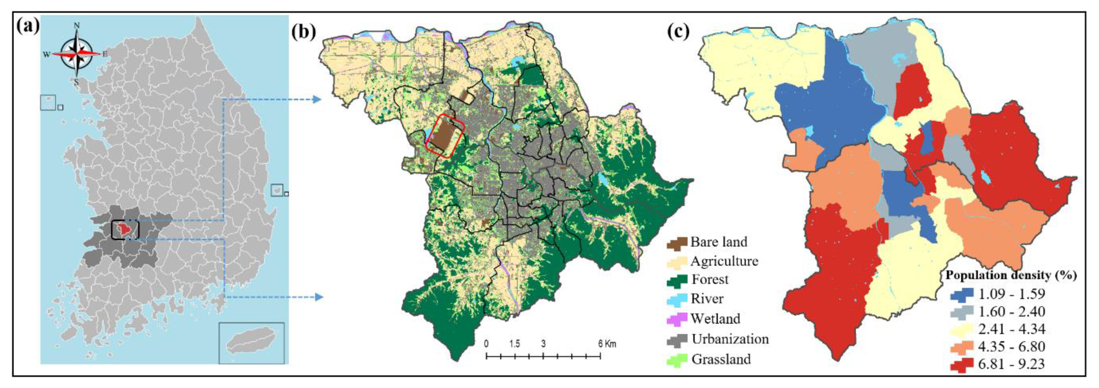
This research aims to address these research questions by developing a geographic information system (GIS)-enabled DT system for sustainable evaluation of carbon emissions. First, the research proposes a logical workflow of a DT environment for sustainable evaluation of carbon emissions. Second, this research applies four factors causing carbon emissions and estimated values of carbon emissions in cluster maps. The estimated values of carbon emissions are used to predict spatial patterns of carbon emissions through support vector machine (SVM) and artificial neural network (ANN) algorithms. Furthermore, this research determines vulnerable areas of carbon emissions resulting from spatial statistics to investigate spatial homogeneities of carbon emissions. Third, this study implements a GIS-enabled DT system in 3D buildings, which represents a virtual representation of the study area.
As a result, this research turns out the following key contributions:
First, this study contributes to the current definitions of DTs in geospatial technology. As stated earlier, the DT has been booming in the manufacturing field, but its definition in geospatial technology has not been clearly defined yet.
Second, this study also guides what technologies are associated with the DT environment or system. Even though a DT system can computerize counterparts of a physical world, it is not merely a digital component of a physical world. Employment of a DT system is not just construction of 3D city models. Thus, it is necessary for city planners or geospatial analysts to comprehend how to establish new skills, particularly connected with the Internet of Things (IoT) technologies. This can help us clearly comprehend how DTs contribute to the digital transformation of society.
Third, the construction of DTs can help urban areas to become more environmentally and economically sustainable because the DT environment enables urban planners to simulate urban planning models that help cities face complex issues such as disasters, carbon emission or infectious diseases like the coronavirus pandemic.
In addition, through this research we expect that the DTs in geospatial technology will bring up a variety of benefits such as efficiency of services, sustainability, safety, economic growth, and more for smart cities.
As such, the DTs in geospatial technology can experimentally mirror real-world problems and resolve urban environmental issues such as carbon emission. Accordingly, this study will help communicate with the general public wanting to acquire carbon emissions information on a local scale.
This paper is structured as follows. The following sub-section introduces previous studies associated with DTs.
Section 2 addresses a structural schematic diagram for a spatially enabled DT system proposed in this study and the study area and a methodological explanation of the SVM algorithm, ANN algorithm, and spatial statistics.
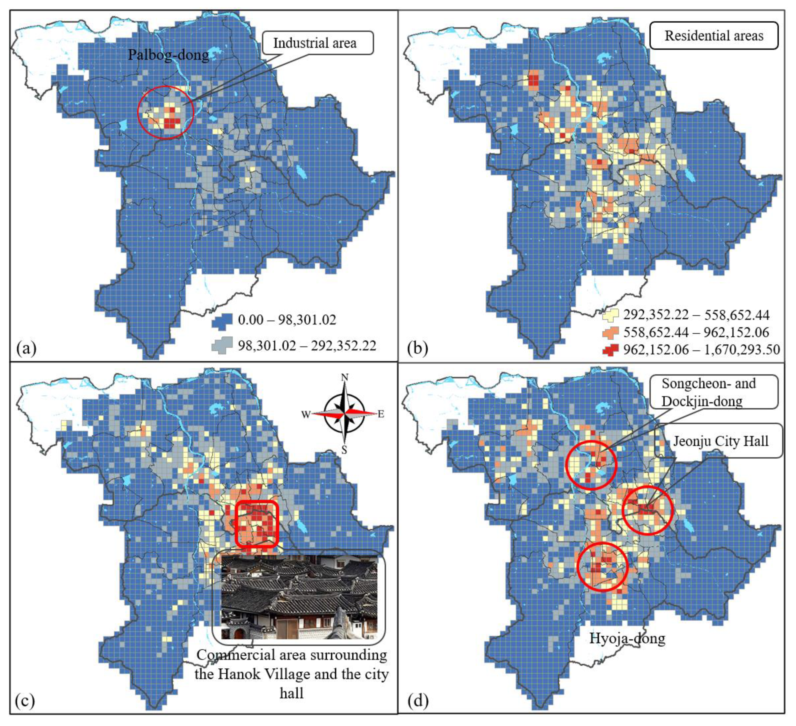
Section 3 presents various mapping results in terms of carbon emissions and outputs of the simulation. Furthermore, GIS analysis is introduced to represent vulnerable areas for carbon emissions on GIS maps. We also introduce how the 3D city model is applied to the DT system.
Section 4 discusses the key contributions of this research and gaps pertaining to DTs. In
Section 5, we present the conclusions of this study.
1.2. Previous Studies
In 2003, the concept of the DT was first introduced in the class delivered by Dr. Michael Grives, a product design expert [
1]. Since its introduction, the demands of DTs have rapidly increased in manufacturing sectors, but the term has only been used in industry and research fields [
12,
13,
14,
15]. In initial DT applications, NASA was the first to experiment with the integrated technology roadmap in the areas of modeling, simulation, and information technology [
12]—building two identical space vehicles to enable mirroring the conditions of the space vehicle [
14]. Ultimately, this was to operate, maintain, and mitigate the damages of physical systems to increase the probability of mission success and living space [
12].
First, the concept of DT varies among researchers. Michael proposed that DTs are the virtual and digital equivalents of a physical product [
1]. Söderberg et al. suggested that they are digital copies of physical systems to perform real-time optimization [
16]. Erkoyuncu et al. defined DTs as digital representations of physical products or systems on multiple scales, created as a digital representation of a physical item or assembly using integrated simulations and service data [
17]. Grieves and Vickers defined a DT as a set of virtual information from the micro-atomic level to the macro-geometrical level [
18]. Alam and El Saddik proposed that a DT is an exact cyber copy of a physical system that represents its complete functionality [
19]. Although many slightly different definitions have been proposed over the last two decades, the goals of DTs are to reduce failures from real-world projects and make a success of the real-world projects.
Second, the scientific literature is still in an early phase. DTs have the same strategies that lower costs and the chances of failing in the real world [
20,
21], but they also reduce the uncertainty of physical environments or systems [
22]. Accordingly, DTs can improve current decision-making processes by providing the most probable outcomes. The outcomes that are possible from a well-developed virtual model consist of testing, planning, simulating, and monitoring the counterparts of physical objects or systems. Simulation enables virtual models to produce optimized outcomes, compared with physical systems [
20].
Third, although the virtual model or its representation is the counterpart of a physical object and may have functionality similar to a physical system, it is intrinsically different from the original physical world. Thus, the virtual environment must have a sophisticated mechanism to plan, simulate, assess, and monitor the physical world. A computerized environment mirroring the real world must be able to simultaneously and infinitely test, simulate, evaluate, and repeat steps of all possible analytical approaches—lessening the risk of failure from a real-world project. Thus, proper and optimized approaches will be required, for which machine learning or deep learning algorithms can be considered. These are the emerging technologies driving the Fourth Industrial Revolution.
This study uses SVM and ANN machine learning algorithms. These technologies enable machines or systems to learn processes and identify problems [
23]. SVM is a supervised machine learning model based on statistical learning theory. This model is used to predict and classify data sets in a hyperplane [
24]. Radial basis functions have been used in a wide variety of disciplines, such as surveying, mapping, geology, and 3D object representations [
25]. The ANN model is widely used to solve various classification and forecasting problems [
24,
26]. It is useful for training large data sets and simplifies complicated processes.
Fourth, although a review of the scientific literature is not well defined, there is growing interest in DTs for geospatial technology. Very recently, DTs received considerable attention as a useful virtual platform that enables urban planners to capture changes to a physical system, monitor all associated activities and movements occurring in cities, and simulate real-world projects [
27,
28]. The growing interest is associated with research and applications of smart cities [
3,
28,
29,
30,
31,
32,
33,
34]. DTs require connections to data and information that connect the virtual and physical worlds [
1].
Representing the physical world in a digital format requires a realistic 3D representation of physical systems or worlds, especially in an urban environment. Thus, it is essential that DT applications are built by integrating GIS and building information modeling (BIM), which can represent real objects such as buildings, vegetation, terrain, roads, and even people’s behavior patterns. Furthermore, levels of 3D representation result in different perspectives in terms of the physical space for each urban planner. Some DTs function to enhance and optimize real-world processes and to monitor and simulate scenario-based projects used to mitigate risks and increase resilience [
31]. Accordingly, the integration of GIS and BIM is an essential technology to deploy DTs to cities.
Concerning DT studies in a city, although the scientific literature is in an initial stage, there is growing interest in terms of exploring developing DT systems in various fields. The DT concept is not just a virtual representation of a physical world but has integrated geospatial technologies that result in lessening the risk of failure due to unforeseen problems, resolving uncertainty from feasible smart city projects, and increasing the spatial perception of the general public that leads to active participation in regional projects.
DTs can provide optimized outcomes for where to focus, which methods to use, and whom to be concerned about for sustainable urban development and preservation in terms of carbon emissions. This research raised the following questions in terms of management of sustainable carbon emissions in a DT system:
- (1)
What are the optimal geospatial technologies to employ GIS-enabled DT systems for carbon emissions?
- (2)
What if we develop scenario-based approaches to mitigate the risk of carbon emissions? What would happen if we change this?
- (3)
How can an urban planner deliver carbon-related information to citizens in real-time?
This research addressed the questions raised in this study by developing a GIS-enabled DT system for the sustainable evaluation of carbon emissions.
4. Discussion
With a rapidly growing interest in DTs in manufacturing sectors, the trend has expanded to various fields. However, this concept still varies, and scientific literature is at an early stage. Even the trend of geospatial technology is at a much earlier stage than for manufacturing sectors. However, in common perspectives, DTs are linked to real-world counterparts and are used to comprehend places where we live and sustainably improve urban systems. Most importantly, DTs are aimed at reducing the uncertainty of physical systems and failures from real-world projects—producing successes for a project and improving current decision-making processes. Thus, it is essential that geospatial scientists design well-developed virtual models consisting of testing, planning, simulating, and monitoring the counterparts of the real-world projects.
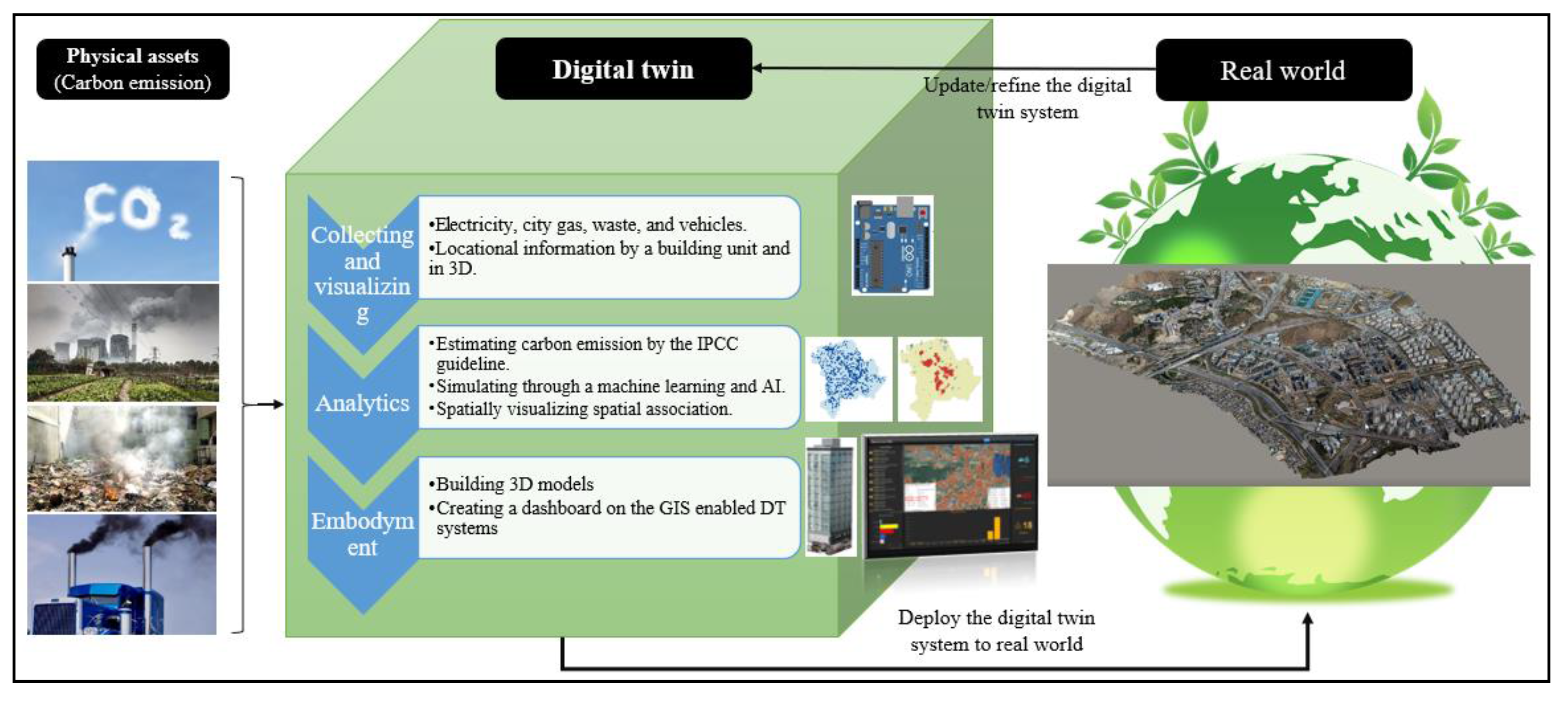
Concerning the above goals, this research was aimed at developing a structural schematic of a GIS-enabled DT system for sustainable evaluation of carbon emissions. First, we developed a conceptual model for DTs that had three phases: (1) collection and visualization of physical assets in a GIS environment, (2) analytics, and (3) deployment. The three steps were designed to propose an optimal strategy to reduce carbon emissions in an urban area.
This study on the development of DTs contributes the following. First, based on the DTs, sustainable urban management systems will be improved, and new insights will be developed in a more public manner—reducing the failure of projects associated with urban planning and management.
Second, the structural schematic proposed in this research shows data-driven approaches. Through the system, urban planners and policy makers can apply the system with scenario-based approaches. Consequently, its outputs will be more reliable and feasible.
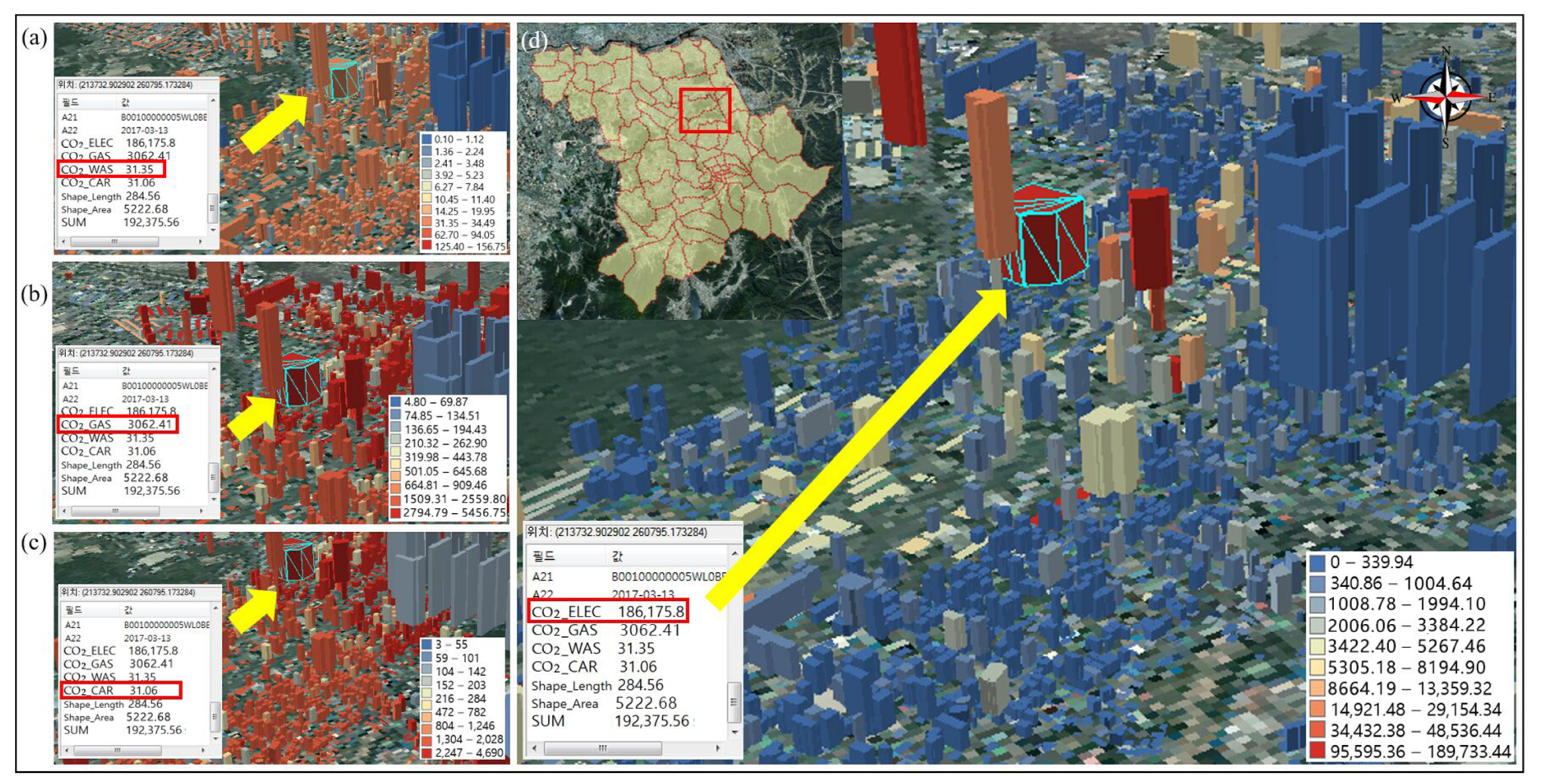
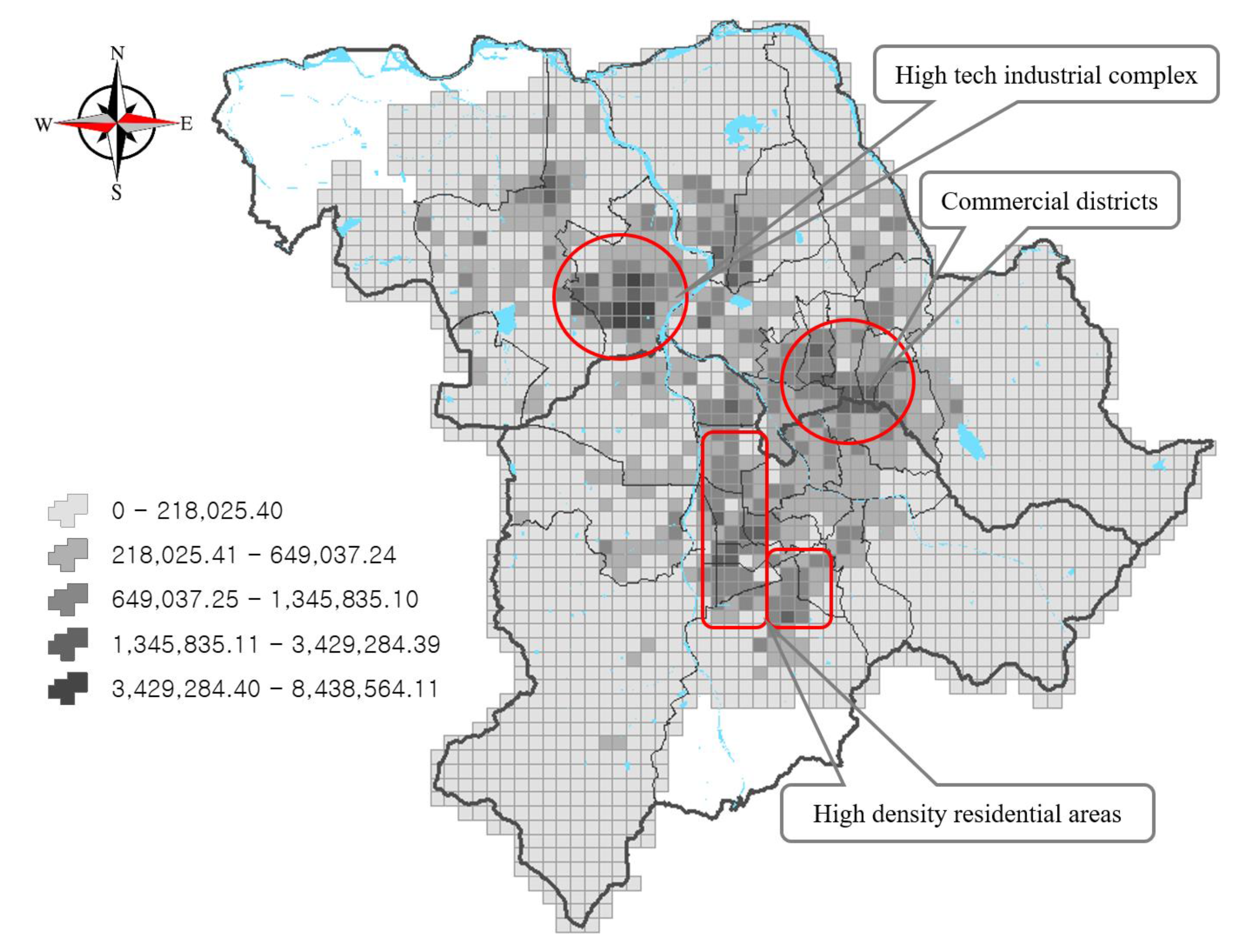
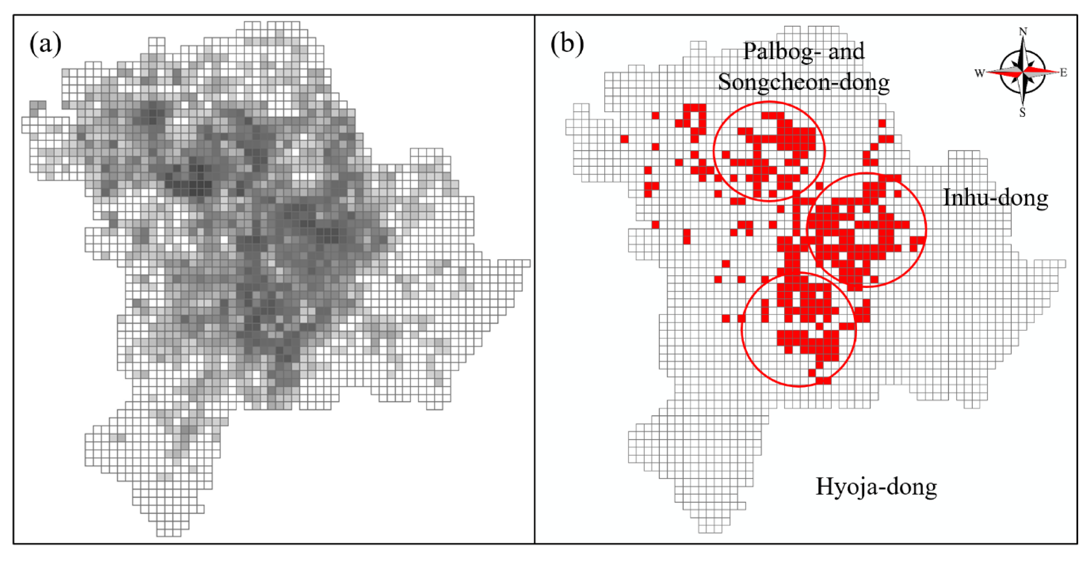
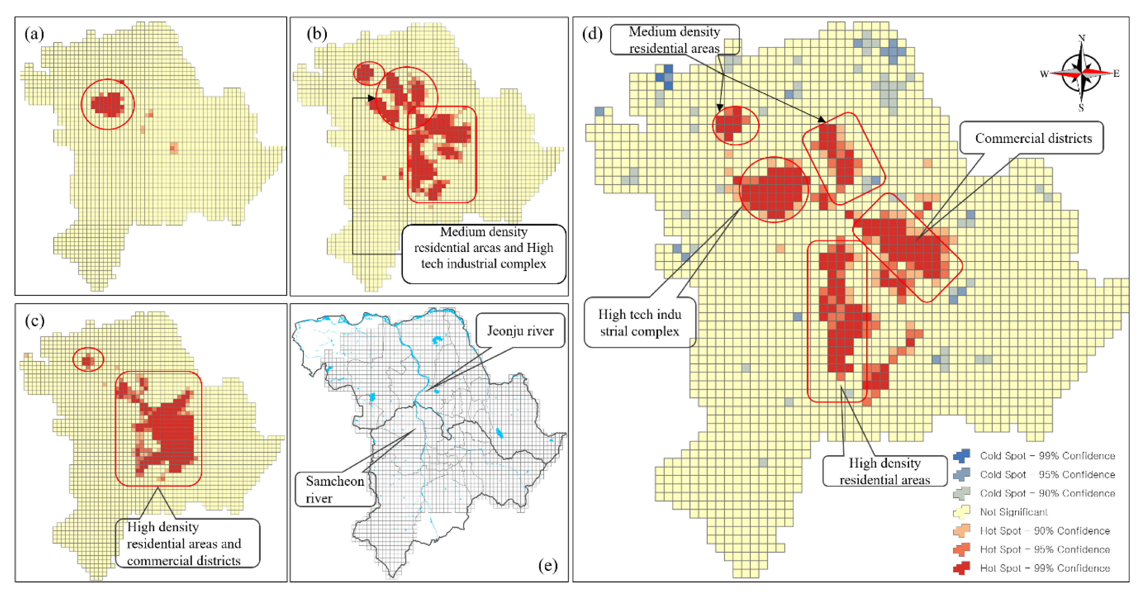
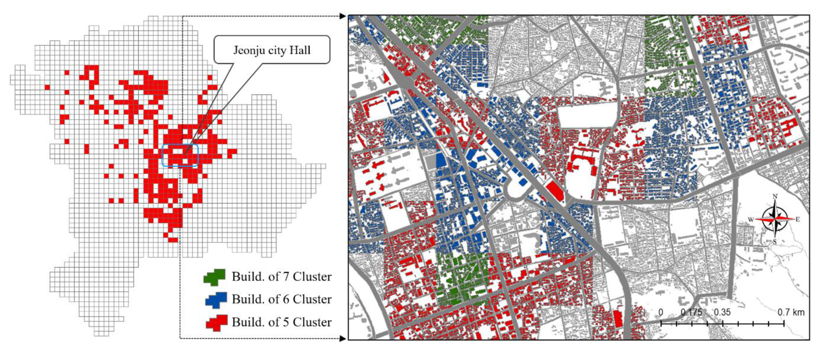
Third, concerning research, the DTs for evaluation of carbon emissions are mapped in a grid of cells of 300 × 300 m and a building unit. This dramatically improves the spatial resolution of the geographic data related to carbon emissions and demonstrates a more accurate representation than current carbon management systems. Thus, the research outputs can be directly applied to reality.
In this research, we identified various considerations that could improve the future development of DTs. The research and applications of DTs in geospatial technology are in an early phase. Although DTs can computerize counterparts of a physical world, they are not merely a digital component of a physical world. Thus, it is necessary to consolidate new skills and competencies and clearly demonstrate how DTs contribute to the digital transformation of society. Consequently, geospatial analysts or scientists need to advance DTs over time by improving their abilities to collect data, visualize data, apply the proper analytics, and respond effectively to the objectives of urban planning and management. Consequently, with this research, we propose the following for future DTs projects.
First, as introduced in this research, DTs for carbon emissions management are based on diverse data sources that need to be combined. Thus, it is important to define what types of data will be feasible and how to collect the data. DTs require new skills and technologies. Accordingly, data collection can be conducted with the IoT connections with sensor technologies to collect real-time data. Furthermore, locational information is an essential source for the deployment of DTs. Consequently, geospatial data and technologies are primary sources for DTs, and the IoT is one of the major drivers in the DT environment.
Second, 3D representation helps urban planners explore, experiment, visualize, analyze, and apply to real-world projects. 3D city models are also important drivers. A higher level of 3D representation is critical to increasing spatial perceptions of events or systems in the real world. When determining the LOD or spatial scale of a 3D city model, we can consider it from the micro- to the macro-geometrical level. The data volume of a 3D city model is burdensome and slows system processing significantly. Furthermore, GIS data comprise the base information used to build a 3D city model. Thus, the optimal map scale and appropriate LOD should be identified for new DTs. The two technologies must be consolidated with the IoT connection.
Third, concerning analytics, the primary goals of DTs are to lessen the risk of failure due to unforeseen problems. Accordingly, well-developed analytics processes must be established. Developers and policy makers must be able to visualize, simulate, evaluate, and then refine and update DTs. Technicians in the manufacturing field use the system daily. Along with the new era of the cloud and big data, machine and deep learning techniques can accomplish the above duties and are also essential elements of DTs. Furthermore, we care about space and place in a virtual environment, even though events are happening in spaces or places. Consequently, engineers must consider the relationships between places, people, and devices when developing DT systems—it is essential to understand how the machine works internally rather than concentrating on the exterior of a device.
Finally, a platform that supports DTs for public and geospatial analysts would be useful. With the Fourth Industrial Revolution, cloud- or web-based applications are popular for those who want to convey information, such as the COVID-19 dashboard developed by The Johns Hopkins University. It enables the public to monitor events and trends, even making decisions and predicting trends on a web-based application. Thus, web-based GIS applications would be one of the major assets for development of DTs.
Even though there are multifaceted contributions of this research, there are direct limitations that should be considered in future studies. First, level of detail in a 3D city model is important, particularly for the public, because it is directly associated with improving spatial recognition of reality. However, this study used LOD 1, which represents only a coarse prismatic model of the 3D buildings. Second, in regard to the web-based GIS application, this research provides only GIS-enabled DTs and not an interactive map like a dashboard. In this study, GIS enabled DTs were not built in a cloud or web-based environment with intuitive and interactive data visualization and analysis. Thus, this will also be one of the major tasks we work on in future studies. Lastly, even though we used machine learning techniques such as SVM and ANN, deep learning algorithms were not considered in this study. Thus, improved ANN algorithms will be considered in future studies.
Consequently, DTs have the potential to massively alter and improve our urban environments, particularly for the sustainable evaluation and management of carbon emissions. Accordingly, it is time for DTs in geospatial technology to evolve and for us to discuss how DTs can contribute to the digital transformation of society or where we live.


