Article

Developing an Environmental Justice Index for Small Island States: The Case of Malta

by
Maria-Stella Portelli
*,
Elisabeth Conrad
and
Charles Galdies
Institute of Earth Systems, University of Malta, Msida, MSD 2080, Malta
*
Author to whom correspondence should be addressed.
Sustainability 2020, 12(22), 9519; https://doi.org/10.3390/su12229519
Submission received: 19 October 2020 / Revised: 9 November 2020 / Accepted: 12 November 2020 / Published: 16 November 2020

Abstract

:
By focusing predominantly on cities or larger regions, environmental justice (EJ) studies have tended to overlook the challenges faced by small island states. This study explores the feasibility of constructing an EJ index for Malta, as a case study of these territories. EJ issues were identified by consulting relevant literature and local experts. Based on this, five environmental variables (air pollution, noise pollution, lack of greenery, overcrowding and overdevelopment, and proximity to locally unwanted land uses) and three social variables (education, unemployment, and health) were selected for inclusion in the index. For the identified variables, indicators were chosen and calculated for each locality, while using a Geographic Information System to process and visualize spatial data. Cumulative environmental burden and social vulnerability scores were calculated based on quintile ranking of indicators. After normalization, cumulative scores were aggregated to derive the EJ index. The preliminary evaluation of EJ distribution in Malta demonstrated significant spatial differences. A statistically significant positive correlation of moderate strength between cumulative environmental burden and social vulnerability scores showed that EJ issues are present in Malta, notwithstanding its small size. Despite limitations, this exploratory index provides a basis for further EJ research in small island states.

1. Introduction

The interconnectedness of environmental and social issues has become indisputable. Vulnerable individuals and communities disproportionately experience environmental burdens, together with barriers that do not allow mobilization against these burdens and the resulting well-being impacts [1,2,3]. Such issues relate to environmental justice (EJ), which addresses “the right to remain in one’s place and environment and be protected from uncontrolled investment and growth, pollution, land grabbing, speculation, disinvestment, and decay and abandonment” [4] (p. 33).
EJ literature is inundated with distributional studies [5], which measure EJ spatially on the basis of defined indicators (e.g., [6,7]). Such distributional analyses are crucial to identify overburdened communities, enabling direct policy measures for rectification, mitigation, and compensation of injustices. For years, European policymakers lagged behind the US in recognizing EJ [8,9] resulting in the majority of methodological studies being based in the US. In fact, a study prepared for the European Commission (EC) recommended embracing EJ as a “guiding principle for policy development” while investing in good spatial data and assessment methods [10].
Despite EJ studies now emerging all over Europe, and more recently in the Far and Middle East, Australia, New Zealand, and South America [5], spatial EJ investigations have focused principally on cities or regions with significant industrial activity and economic development (e.g., [11,12,13]); as a result, the specific context of small island states has generally been overlooked. While small island states are not homogenous, common characteristics such as size limitations, remoteness, insularity, and vulnerability to external shock have resulted in their recognition as a distinct group: For instance, the United Nations recognizes small island developing states as “special cases” for sustainable development [14]. Small island states have often been highlighted in relation to climate justice, the conceptualization of which has been greatly influenced by the environmental justice movement and discourse [15]. This has focused on the disproportionate vulnerability of these territories to climate change, notwithstanding their insignificant contribution to global greenhouse gas emissions [16].
However, disparities are not only found at the global scale, between small island states and other countries, but also within small island states. Indeed, the small size of these territories precludes neither significant social disparities nor disproportionate distribution of environmental burden largely affecting the most vulnerable communities. The dynamics leading to EJ concerns in cities and regions may also be present in small island states. This work is based on the premise that the processes and dynamics taking place on the mainland can be enhanced and exacerbated on islands, and that “islandness is an intervening variable that does not determine, but contours and conditions physical and social events in distinct, and distinctly relevant, ways” [17] (p. 278). For instance, given their size constraints, options for relocation, mitigation, and compensation of environmental burdens are limited, as these have to be located in someone’s backyard. Evidence of injustice or inequitable distribution of burdens in small island states already exists. For instance, a study on social work perspectives on climate change and vulnerable populations in Caribbean small island states highlighted the compounding impacts climate change has on vulnerable groups, in particular those facing poverty, racial discrimination and segregation, and socio-economic vulnerabilities [18]. Another study on the Caribbean islands and islands of the Southwestern Indian Ocean underlined how increased economic inequalities and political exclusion, often associated with these islands’ colonial history, result in compounding climate change effects [19]. Even industries like tourism have been found to entrench and exacerbate social inequalities in some small island states such as the Maldives [20], which has reported widening economic disparities and higher poverty incidences, notwithstanding governmental intervention and significant growth in the tourism sector [21].
At the same time, it is evident that small island states are not benign in their environmental impact. For example, Bradshaw et al. [22] ranked the small island state of Singapore as the worst performer out of 228 countries in terms of proportional environmental impact, with Iceland and Malta also featuring in the top 20. Island nations such as Aruba, Singapore, the Cayman Islands, and Malta are likewise amongst those with the highest ecological footprint per capita [23]. This contrasts with a popular perception of small islands as models for sustainability; indeed, Grydehoj and Kelman [24] note how the ‘eco-island’ development approach is often no more than a form of conspicuous sustainability that can trap islanders in patterns of unsustainable behavior.
The existence of both environmental burdens and social inequalities in small island states is thus known but related research on the link between the two remains lacking, with few relevant examples (e.g., Bogadóttir’s [25] analysis of social and ecological conflict in the Faroe Islands) and very limited work on the spatial quantification and distributional analysis of EJ in small island states in particular. Given this gap, this study aims to explore the feasibility of constructing an EJ index for the European small island state of Malta. In Malta, EJ research is in its infancy and EJ tools are as yet unavailable, despite growing focus on the effects of environmental degradation on health by governmental entities, academics, and citizens (e.g., [26,27,28,29,30]). This study contributes results of relevance to this case study but also broader insights that are of relevance to the development of EJ methods for smaller territories, where the distinction between urban and rural contexts may be ambiguous, and where the distribution of environmental goods and bads is heavily constrained by size.

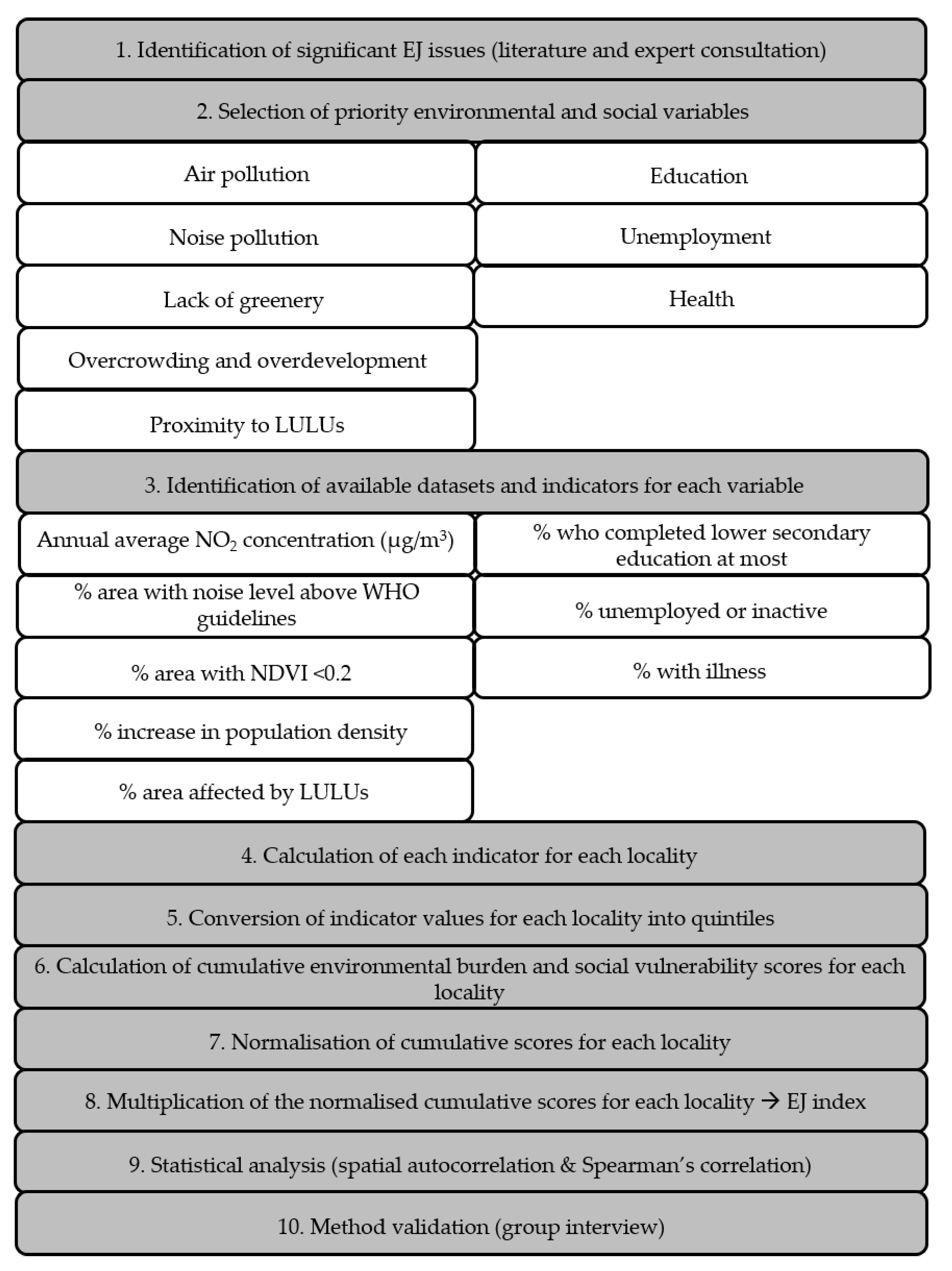
2. Materials and Methods

A methodological workflow synthesizing the steps taken is provided in Figure 1.

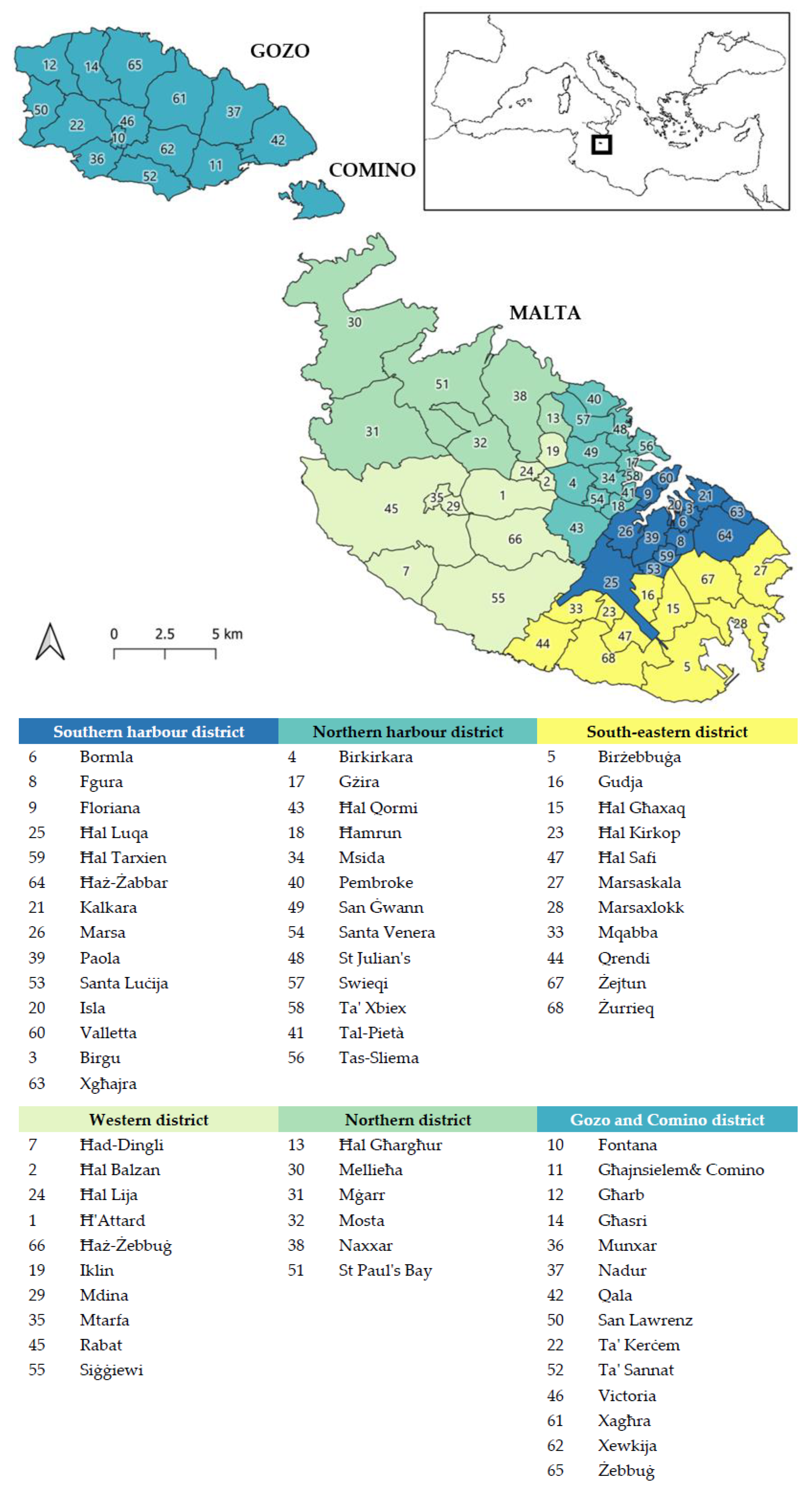
2.1. Study Area and Geographic Unit of Analysis

The Maltese Islands (Figure 2), collectively referred to as Malta, had a population of 493,559 individuals at the end of 2018 [31] in a land area of just 316 km2. A 20% increase in population was registered from 2008 to 2018, partly attributed to immigration [31]. The resulting high population density, in a context of limited natural resources, exerts considerable pressures on the environment [32]. This is exacerbated by Malta’s strong dependence on tourism, which contributed 15.8% of the country’s GDP in 2019 [33]. Inbound tourism has been increasing steadily over the past years [31], reaching almost 2.8 million trips during 2019 [34]. Moreover, recent increase in economic development has placed tremendous pressure on the environment and ostensibly led to aggravation of serious EJ issues such as air quality. Within the EU, Malta has been ranked as the country with by far the highest percentage of reports of exposure to “pollution, grime or other environmental problems” [35]. Waste management also faces huge challenges of space availability [36].
The 68 Maltese localities vary in area from 0.16 km2 to 26.60 km2 and in population numbers from 237 to 26,133 [37]. Notwithstanding these variations, locality was chosen as the geographic unit of analysis, since this was the finest unit for which data were available.

2.2. Identification of EJ Issues

To identify significant EJ issues in Malta, literature was reviewed, to identify both general and context-specific issues of relevance. The validity of information found in literature was reaffirmed or reconsidered by consulting with 12 experts from relevant fields: activism, air quality, climate change, sustainable energy, environmental chemistry, environmental law, public health, social work, transport, urban design, waste, and water. Experts were chosen based on their familiarity with the local context and expertise, and were recognized through their published work, lecturing portfolio, online professional profiles, and recommendations by other experts. Expert consultations took the form of one-to-one semi-structured interviews of approximately 45–60 min in 10 cases and email questionnaires in another two cases (when interviews were not possible). The research abided by the University of Malta (UM) Research Code of Practice and followed UM Research Ethics Review Procedures. Participants gave their consent to be audio-recorded.
The discussion points explored included potential EJ concerns and their impacts, potential receptors of injustices, relative priority of EJ concerns, and recommendations for method development. The questions used as an interview guide are found in Table 1.
To determine the priority issues and variables to include in the index, interview transcripts and questionnaires were coded inductively at descriptive and thematic nodes by the first author and queries were run to visualize EJ issues and receptors of injustices flagged by each expert, using NVivo Pro 12 software. Experts were not re-consulted about the coding outcomes. The responses are summarized in Table 2.

2.3. Selection of Variables

Air pollution due to transport was considered a priority issue given the severity of health impacts [38,39,40], strong public concern [32,41], discussion in national publications [26] and official reports [27,30], and repeated mention by the majority of experts during the semi-structured interviews. Moreover, it is the most common variable in European EJ studies [10] and is considered the single most important environmental determinant of health globally and in the EU [39,40,42]. Noise pollution was also selected based on the severity of physiological and psychological health effects [43], growing public and political concern [3,27,30,43], lack of consideration of impulse noise and noise reduction targets in the EU Environmental Noise Directive (Directive 2002/49/EC of the European Parliament and of the Council of 25 June 2002 relating to the assessment and management of environmental noise) [26] translating into inadequate noise regulation in Malta, and repeated mention by several experts during the semi-structured interviews. Greenery (or lack thereof) was considered a priority issue due to its emphasis by several experts, identification in official national reports (e.g., [27,30]), and its ability to compensate for environmental burdens. Although issues of overcrowding and overdevelopment are seldom included in EJ research, these are topical issues in Malta, which have resulted in a number of protests [44] and are particularly relevant given the above-mentioned population pressures. The issue of siting of waste facilities was mentioned by a third of the experts; furthermore, Malta is struggling to fulfil the EU Waste Framework Directive (Directive 2008/98/EC of the European Parliament and of the Council of 19 November 2008 on waste and repealing certain Directives) targets [26], and siting of polluting facilities is a recurrent theme in literature. Locally unwanted land uses (LULUs) were therefore prioritized.
To distinguish between different potential receptors of injustices, unemployment, education, and health were considered as priority social variables, based on literature (e.g., [45]), experts’ responses, national reports [27,30], and availability of data. Other variables shown in Table 2 (e.g., climate change, energy affordability, and age) were not included due to lower assigned priority, unavailable data at the desired level, or unavailable data at the time of the study.

2.4. Selection and Processing of Indicators

For each identified priority environmental and social variable, indicators that met SMART (specific, measurable, attainable, realistic, and timely) criteria were identified, depending on available secondary data provided by national authorities and professional entities (Table 3).
Data processing was carried out principally in QGIS 3.8.1 Zanzibar. Indicators were selected and processed for each locality as described in Section 2.4.1, Section 2.4.2, Section 2.4.3, Section 2.4.4 and Section 2.4.5. This was done by extracting the boundaries of each locality as polygons from the basemap and clipping the environmental variable layers to each locality using the Clip Tool. In cases identified below, the environmental variable layers were clipped to the locality built-up area (BUA) since environmental burdens experienced by BUAs (where most people are located) of localities with significant unbuilt areas would be diluted if considering the whole locality area. A BUA layer was created from OpenStreetMap (OSM), available in QGIS. Using QuickOSM plugin, multiple quick queries (e.g., amenity, building, historic, residential, commercial, industrial, leisure, and office) were run to extract polygon features to represent BUAs. The resulting layers were merged and dissolved into one layer and clipped to each locality polygon to obtain locality BUAs. Table 4 summarizes limitations related to the datasets available and indicators used. Raw data for environmental indicators and data related to processing of environmental indicators is found as supplementary material (Tables S1–S6).
Social indicators were calculated for each locality using Microsoft Excel®. Since income data per locality were not available, unemployment was considered instead. The inactive population was considered jointly with the unemployed. The inactive cohort includes individuals who are students, undertaking unpaid job experiences, retired, unable to work due to disability or illness, taking care of family or house, and any other inactive persons. These were considered as vulnerable since they either lack a steady income or are retired (hence, indirectly considering age as a vulnerability). Similarly, early school-leavers were selected to represent education since they are strongly associated with various aspects of wellbeing [46]. Health-related census data were used as an indicator for health status. These data included any long-term illness, disease, and/or chronic conditions such as diabetes, asthma, and heart disease. Raw data for social indicators and data related to processing of social indicators is found as supplementary material (Tables S7–S10).

2.4.1. Annual Average NO2 Concentration

The pollutants of highest concern to human health in Europe are particulate matter (PM), nitrogen dioxide (NO2), sulfur dioxide, and tropospheric ozone [39,47]. Since the discussion revolved around transport emissions, only NO2 and PM were considered; ozone is attributed to transboundary pollution and sulfur dioxide is no longer of concern locally after discontinuation of use of heavy sulfur fuel [39]. Data for PM were only available from 4 monitoring stations; NO2 was therefore selected as the most relevant pollutant, with data available from a passive diffusion tube network of around 100 stations and interpolated (using Kriging method) to produce annual average maps.
The resulting raster data were reclassified into 7 classes based on NO2 concentration ranges and clipped to each locality BUA. The count of pixels of each class was used to calculate a weighted mean for each locality. The weighting factor was the proportion of number of pixels per class out of the total number of pixels while the concentration of NO2 was the mean of the two extremes of the range of the class, such that:
N =   ( C 1 T × 12.5 ) + ( C 2 T × 17.5 ) + ( C 3 T × 22.5 ) + ( C 4 T × 27.5 ) + ( C 5 T × 32.5 ) + ( C 6 T × 37.5 ) + ( C 7 T × 42.5 )
where N is the annual average NO2 concentration per locality BUA, C is the count of pixels pertaining to each class (C1: 10–15 µg/m3, C2: 15–20 µg/m3, C3: 20–25 µg/m3, C4: 25–30 µg/m3, C5: 30–35 µg/m3, C6: 35–40 µg/m3, C7: 40–45 µg/m3), and T is total number of pixels in locality BUA.

2.4.2. Percentage Area with Noise Levels above WHO Guidelines

The three noise layers indicated in Table 3 were reclassified such that values below the WHO recommended value (53 dB Lden for road traffic noise and 45 dB Lden for aircraft noise [43]) were assigned a value of zero while those above were assigned a value of one. The reclassified layers were merged and clipped to each locality BUA. In the process, zero values were converted to ‘No Data’. The area of the resulting clipped layers (i.e., where noise was above threshold) together with the area of the locality BUA were used to calculate the percentage area where noise level was above WHO guidelines.

2.4.3. Percentage Area with NDVI < 0.2

Although both green and recreational spaces can be relevant to EJ issues, green spaces were considered, since most literature and experts specifically discuss vegetation. Green space is often seen as a compensatory measure for environmental burdens due to its benefits. These include improved mental health and a lower mortality [48]. To avoid the rather arbitrary choice of a buffer radius, a satellite image was used to determine NDVI as a proxy for greenness. It was assumed that green space that is present but not necessarily accessible, such as private gardens and agricultural land, also provides environmental benefits. NDVI was calculated using Bands 4 (Red) and 5 (Near infrared) of a cloudless Landsat 8 satellite image. The NDVI layer was clipped to each locality and split into two classes: <0.2 and ≥0.2. A cut-off value of 0.2 was chosen since NDVI values between ~0.2 and 0.5 usually indicate sparse vegetation like shrubs and grasslands, and senescing crops [49], typical of green areas in the Maltese semi-arid landscape. Higher values (~0.6 to 0.9) reflect dense vegetation and low NDVI values (−1 to ~0.1) correspond to barren rock, sand [49], sea, and buildings. The areas of each class were used to calculate the percentage area with NDVI <0.2 for each locality.

2.4.4. Percentage Increase in Population Density (2011–2017)

Analyzing the number and nature of development permits can indicate hotspots of growth and areas where construction of new buildings is potentially leading to overcrowding. However, this would have required substantial detailed analysis that was beyond the scope of this work. A simpler proxy indicator to indicate overdevelopment and overcrowding was therefore adopted: Percentage increase in population density from 2011 to 2017 (years chosen according to available data). The percentage increase in population density for each locality was calculated as follows:
%   i n c r e a s e   i n   P =   ( P 2017 P 2011 P 2011 ) × 100
where P is population density.

2.4.5. Percentage Area Affected by LULUs

High-risk facilities that require an IPPC permit according to the Industrial Emissions (IPPC) Regulations (Legal Notice 10 of 2013) based on the EU Industrial Emissions Directive (Directive 2010/75/EU of the European Parliament and of the Council of 24 November 2010 on industrial emissions (integrated pollution prevention and control)) were identified as LULUs. These include major waste facilities. Since the spatial coincidence method gives the least accurate results [50], a proximity-based approach using buffers was used. A risk-based approach was not possible without further studies or unwarranted assumptions.
The IPPC installations marked as active or being processed by ERA were drawn as polygons on one GIS layer with a 1.5 km buffer radius. This distance was selected by extension, since the Maltese government credits households within a radius of 1.5 km of a particular waste treatment plant with an amount of electricity [51], presumably a form of compensation for environmental burdens suffered. Overlapping buffers were dissolved. The buffer layer was intersected with each locality BUA. The area of the extracted features was used to calculate the percentage of locality BUA overlapping with the buffer zone.

2.5. Normalization and Aggregation

Normalization and aggregation were performed twice in the construction of the index as illustrated in Figure 3. First, raw values from each indicator were normalized by ranking them into quintiles (from one to five): The first 20% of the population was given a value of one, and so on. Although quintile ranking loses specific information as the range of values is transformed into five encompassing values, it was found to be a meaningful, simple, and transparent method in other EJ studies (e.g., [52,53]). Moreover, it avoided the possibility that maxima are outliers, which unintentionally become benchmarks that skew data [54]. Subsequently, environmental and social variables were added to produce cumulative environmental burden and social vulnerability scores. This linear aggregation assured compensability, meaning that one indicator’s good performance compensated for poor performance of other indicators [54]. This was essential to visualize the cumulative environmental burden from the five environmental variables and the cumulative social vulnerability stemming from the three social variables.
The second normalization of cumulative scores was performed by dividing cumulative scores by the maximum of the range (25 for the cumulative environmental burden score and 15 for the social vulnerability score). By using the maximum, without considering the minimum, the scores were rescaled to values between zero and one, but not from zero to one. Avoiding zero values meant that during aggregation by multiplication in the following step, values were not lost by automatically giving a zero EJ index. The geometric aggregation used to generate the EJ index offered partial compensability and rewarded localities with higher scores [55]. When multiplying, the greatest score is obtained when both scores are the same. This means that the greatest EJ index score is obtained when both the cumulative environmental burden score and cumulative social vulnerability score are the same and have a high value, thus reflecting EJ concern. The EJ index score for each locality is found as supplementary material (Table S11).

2.6. Statistical Analysis

The Spatial Autocorrelation (Global Moran’s I) tool found in the Spatial Statistics toolbox in ArcMap® was used to evaluate whether features are randomly distributed across the area. The features tested were each environmental and social variable, the normalized cumulative scores, and the EJ index.
The correlation between environmental burden and social vulnerability scores was assessed using Spearman’s correlation test in IBM® SPSS® Statistics 26.

2.7. Method Validation

To validate the method developed and identify possible improvements, a focus group with the experts previously interviewed was conducted. Due to time and scheduling constraints, only some of the experts were able to participate. However, the expertise of those present was quite varied (urban design, social work, sustainable energy, and environmental chemistry) and was considered acceptable. During the focus group, the methodology adopted and results obtained were briefly presented. Following this, a discussion took place around the validity and utility of the index and possible improvements. The recording was transcribed, content analyzed, and salient points were extracted and summarized.

3. Results and Discussion

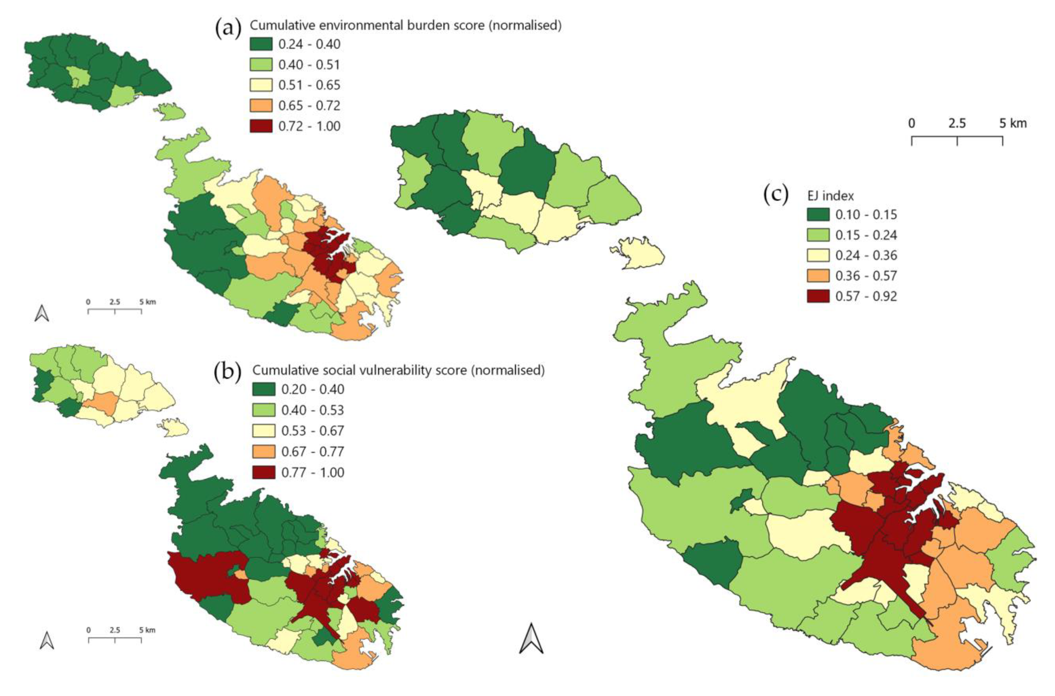
3.1. EJ Index Outputs

As with any interpretation of indices’ output, the discussion of results should be embedded within the limitations presented in Table 4 and discussed in Section 3.2. The most noteworthy result was the statistically significant (p = 0.002), positive, and moderately strong correlation (Spearman’s Coefficient = 0.364) between the cumulative environmental burden and social vulnerability scores (Figure 4). Localities in the top right corner of Figure 4 are of particular interest, since these have both high environmental burden and social vulnerability and were the localities that received the highest EJ scores. Moreover, spatial autocorrelation of environmental and social variables, cumulative scores, and the EJ index showed that these are not randomly distributed between localities and exhibit a tendency towards clustering (p-values < 0.05, z-scores beyond −1.96 and 1.96, and a positive Moran’s I index), even in such a limited land area. Detailed spatial autocorrelation results are found in Table S12 of the supplementary material. This contradicts the postulation of a third of the experts interviewed, who claimed that due to Malta’s small size, environmental parameters (even if localized) impact mostly everyone. These results support the premise that EJ concerns are present in Malta and may also be relevant in other small territories. This work thus joins a body of international research demonstrating the relevance of environmental injustice as a policy concern.
Further statistical analysis of correlations between each environmental and social variable showed positive relationships in most cases (Table 5), with the strongest positive statistically significant correlation between illness, on the one hand, and NO2 concentration, lack of vegetation, and noise. Inferences that higher percentages of illness are due to higher environmental burdens should not be made since illness can also be the cause of reduced mobility and mitigation potential against environmental burdens. Moreover, since all types of illness are grouped together, one cannot draw conclusions about cause-effect. At a minimum, this positive correlation merits further studies.
The distribution of the cumulative scores and EJ index scores also yielded interesting results, although care should be taken when interpreting these due to limitations discussed in Section 3.2. The normalized cumulative environmental burden score (Figure 5a) showed lowest values in Gozo and Comino and the Western coast of Malta, while the Northern and Southern Harbour districts show the highest scores. The social vulnerability score (Figure 5b) was lowest in the Northern district and highest in the Southern Harbour district, with Gozo and Comino mostly showing moderate to very low scores. When aggregated, these give an indication of EJ distribution in Malta (Figure 5c) with the greatest EJ concerns in the Northern and Southern Harbour, and South-eastern districts. This distribution reflects land-use patterns, with the greatest EJ concerns related to areas with high urban activity and densest human populations.
Maps showing the distribution of each environmental indicator and social indicator are available as supplementary material (Figures S1–S5 and Figures S6–S8 respectively).

3.2. Method Performance

Construction of indices inevitably leads to compromises, choices, and uncertainties, which should be explicitly recognized to ensure transparency and iterative development [54,55]. The sections below discuss and rationalize various aspects of the methodology, including uncertainties, limitations, and their influence on findings. This is essential to avoid unjustified generalization and ensure transparency, a fundamental aspect for the development of credible indices as stressed in several studies (e.g., [54,55]).

3.2.1. Geographic Unit of Analysis

The geographic unit of analysis greatly affects method performance. For instance, use of large units of analysis results in less reliable inferences since it disregards high variability within [45], leading to aggregation bias [56]. In this case, the smallest unit of analysis for which data were available, locality, was used. However, it posed several difficulties. First, localities are not homogenous units. Two socio-economic extremes can characterize one locality while gentrification may push lower social strata out. Moreover, it is recognized that not all individuals within a geographic unit experience the same risk and health impacts [57]; for instance, people living along busy roads experience greater environmental burdens. Such features at the micro-locality level are diluted when using locality as the unit of analysis.
Second, areas and populations vary considerably between localities. Consequently, when assigning one value for each locality, localities covering large areas suffer from wide generalization, potentially distorting data.
Third, at the locality level, social data were available only from the census, which is conducted every 10 years. Hence, relying on census data results in outdated data for most years. Ideally, census enumeration areas (equivalent to census tracts), which are smaller, more consistent units of analysis, are used. However, such data were unavailable to the authors due to data protection constraints, with these especially relevant in small island states.
Fourth, the arbitrariness of the unit’s boundary is a concern [58]. For instance, an environmental burden at the periphery of the unit boundary may influence the adjacent unit as well.
As alternatives, neighborhood and community level analyses are preferred [45]. Splitting localities into parts was considered. However, this was constrained by data availability and lack of research to rationalize organic delineations having similar social characteristics. A grid method which divides the study area into equal grids, is another option. Nonetheless, this also has significant limitations of data availability and artificiality of boundaries.
Notwithstanding the aforementioned limitations, using locality as a unit was still considered the best available option without engaging in unrealistic data collection endeavors. Moreover, this unit of analysis offers several benefits. First, since currently there is no universal categorization of localities into regions by national entities, use of localities offers the flexibility necessary for application by any entity. Second, it supports policy at localized level to address different realities within different localities rather than a one-size-fits-all policy, which is often justified in small island states. Third, the index could empower local councils with data to push their agenda and launch community initiatives through bottom-up approaches.

3.2.2. Indicators and Weighting

Construction and quality of indicators can be hindered by unreliable, incomplete, and outdated secondary data, an issue reported by several authors (e.g., [52,59]). In this case, not-so-recent census data for social variables were the most updated social data available at the locality level at the time of the study. Using it in conjunction with recent environmental data for environmental variables was considered justifiable in the context of a feasibility study. However, it partly hindered interpretation of results. In fact, experts noted that the social variables did not capture a recent phenomenon of social deprivation in the North of Malta. Furthermore, there are doubts about the completeness of data when considering that undocumented persons living in poor conditions having high social vulnerability are rarely captured in official data. Some variable-specific limitations highlighted in Table 4 can potentially be addressed through further research, for instance, by adopting a risk-based approach to LULUs and accounting for different levels of accessibility to green space. Adding new indicators representing issues such as political vulnerability and procedural aspects of EJ, natural blue spaces as environmental goods, and climate change vulnerability, would likewise be steps towards a more comprehensive EJ analysis.
Despite limitations, relying on secondary data allowed the use of multiple variables, contributing towards better visualization of cumulative impacts. However, difficulties in defining indicators that account for compounding, intergenerational, and spatially or temporally distant effects such as transboundary pollution still need to be overcome through further research.
Another constraint of the environmental indicators stemming from restrictions of available data is that these illustrated the percentage coverage of the locality affected by the environmental burden. Hence, if a small portion of the locality was heavily affected, it was assigned a low value. Moreover, since issues can be represented by several indicators and redundancy between indicators is undesirable, clarity on what the indicator is representing is imperative. The DPSIR framework (drivers–pressures–states–impacts–responses) is a good method to build a theoretical framework from which to extract indicators in a less subjective manner. Alternatively, systems modelling (as proposed by Burgass et al. [54] to simultaneously address multiple uncertainties and involvement of stakeholders (including experts, policymakers, and the public) would not only lead to less subjective theoretical frameworks but also better selection of indicators and their weighting. Differential weighting of environmental and social variables are important refinements for this exploratory index to develop into a robust index. Such refinements were not introduced at this stage due to lack of data on which to base weighting rationales. Nevertheless, cumulative scores should retain equal weighting since both social and environmental issues are equal components of EJ.

3.2.3. Method Validation

The method used to develop the EJ index generally followed the 10-step process of the Handbook on Constructing Composite Indicators [55]. After discussing the appropriateness of indicators, the focus group participants concluded that the index generated interesting data that are useful for policy, particularly if more recent social data can be used and with further methodological refinement, as discussed above. This should include robustness analysis such as uncertainty and sensitivity analysis [54,60], as well as further work on multivariate analysis and weighting. Such analyses should complement validation by experts.

3.3. Reflections on the Role of EJ Indices

Beyond results and methodology aspects discussed above, there are far-reaching questions that raise important discussions about the essence of EJ indices. For instance, there are clear limitations of EJ indices built to address EJ issues of cities or countries in isolation (such as this one), without considering the global picture. Policy intervention based on such indices runs the risks of externalizing environmental burdens. Small island states in particular are often distant from markets and experience limited natural resources, dependence on imports, and few opportunities to develop economies of scale [14]. Such a context facilitates externalization of impacts. For example, Malta, Iceland, and the Maldives all have a ratio of external to total water footprint above 80% [61]. Therefore, extra care should be taken to identify routes of externalization of environmental burdens when investigating small island states. Moreover, local policy can be futile in addressing local impacts derived from global issues, unless intervention is multilateral. On the other hand, deriving global EJ indices is a massive endeavor filled with organizational and political hurdles. Furthermore, the overvalued objectivity indices confer can lead to their use as marketing and public relations tools [62] or to support predetermined positions [63], potentially leading to severe political implications. Moreover, as seen from the Environmental Performance Index [32] and other indices (e.g., [64]), meaningful outputs are difficult to obtain from globally applicable indices, which uniformly treat vastly differing territory sizes and circumstances. The resulting trade-offs mean that global indices fail to represent global phenomena due to limited ability to capture local peculiarities. Attempting to portray both simultaneously is probably misguided. As a compromise solution, localized indices can be effective if they are transparent, iteratively developed, and if externalization of environmental burdens is not supported.
The utility of EJ studies and indices may also be questioned given that realistically, EJ cannot be fully achieved in a society shaped by the neoclassical economic model. Whether at national or international scale, the market driven by capitalism and consumerism forces the environmental pressures that the system creates onto the most vulnerable [65]. Consequently, an EJ approach can only mitigate EJ concerns. Regardless, it is an important first step in ameliorating the situation. With Malta being a strong welfare state with free access to education, healthcare, and several benefits to the socially deprived, one might argue that there is less need for EJ studies. However, by demonstrating that some localities have a higher EJ burden than others, this study showed that welfare states do not guarantee EJ and environmental regulations and location-specific policies are necessary to offset environmental injustices created by market forces. Similar conclusions were reported in Sweden [66] and the Netherlands [11]. Nonetheless, in strong welfare countries, where the norm is to redistribute wealth, actions resulting from EJ studies are arguably more likely to be accepted and impactful.
A great impetus for EJ in Europe was the Aarhus Convention, which among other pillars, promotes access to information. However, the revealing and mapping of vulnerable communities in EJ research can be counterproductive by leading to their stigmatization and politicization. This should be considered in the way information is gathered and presented, and initiatives and measures running in parallel should be in place to turn such consequences into opportunities for empowerment and justice. This will assist citizens in fulfilling the other two pillars of the Aarhus Convention: Ability to participate in decision-making and access to justice to challenge decisions in environmental issues. By empowering communities with new data and information, EJ studies should assist communities to become cognizant of and advance their cause.

4. Conclusions

This study demonstrated that developing an exploratory EJ index for the small island state of Malta involves several limitations and challenges but that there is potential for a robust index. Apart from universal limitations in EJ research and construction of composite indicators, other challenges encountered were more specific to Malta. Nevertheless, the index has generated useful insights and there is evident scope for its further development. This should take place through an ongoing research and monitoring effort that includes various stakeholders, including local communities, and allows for policy adjustments as new knowledge is obtained, but without delaying intervention until the system is fully understood [67]. Such an endeavor requires substantial funding, resources, and political support and would ideally be adopted by national authorities and supported by various Ministries. Moreover, this study has exposed the need for social data (especially related to income and poverty) at the locality level. Use of this data in EJ indices, amongst other areas, would enhance its robustness to generate essential information for evidence-based policymaking, which addressed the different realities experienced by different localities. Therefore, we call for policymakers and national authorities to invest in regular gathering of finer social data while still respecting the confidentiality of individuals.
A robust EJ index can support multipurpose projects and whole-of-government and whole-of-society approaches. Additionally, consideration of the EJ index during impact assessment for policies, projects, or plans could support identification of localities where compensatory measures by the government and planning gain by the developer are necessary. It could also be used to screen localities, which merit further studies and assessment. In the long term, the EJ index can be used to monitor progress of policy targets [68] and act as a policy appraisal tool.
Although challenges with EJ methodology remain, criticism should be capitalized on to address challenges rather than suppress development of EJ monitoring tools altogether [68]. Moreover, more distributional studies of small island stands are necessary to investigate, understand, and compare the peculiarities of EJ studies in smaller territories. After all, “there is no better comparison for an island than another island” [17] (p. 278).
The EJ paradigm may not be able to eliminate injustices; however, it can contribute to evidence-based policy that strengthens and integrates environmental and social policy, ultimately mitigating burdens to the greatest degree possible.

Supplementary Materials

The following are available online at https://www.mdpi.com/2071-1050/12/22/9519/s1, Table S1: Values for each environmental indicator with the corresponding quintile score, cumulative environmental burden score and normalized cumulative environmental burden score provided for each locality (sorted by district), Table S2: Calculating the annual average NO2 concentration using data obtained from the Zonal Histogram tool in GIS, Table S3: Calculating the percentages of BUA with noise level above the WHO guidelines by using data obtained from GIS processing of the noise layers, Table S4: Calculating the percentage area with NDVI < 0.2 using data obtained from GIS processing of the NDVI raster layer, Table S5: Calculating the percentage increase in population density, Table S6: Calculating the percentage area affected by LULUs using data obtained from GIS processing, Table S7: Value for each social indicator with the corresponding quintile score, cumulative social vulnerability score and normalized cumulative social vulnerability score provided for each locality (sorted by district), Table S8: Calculating the percentage of the population who completed lower secondary education at most, Table S9: Calculating the percentage of the population who are unemployed or inactive, Table S10: Calculating the percentage of the population with illness, Table S11: The EJ index score for each locality (sorted by district), Figure S1: Annual average NO2 concentration (µg/m3) in quintiles, Figure S2: Percentage area with noise level above WHO guidelines in quintiles, Figure S3: Percentage area with NDVI < 0.2 in quintiles, Figure S4: Percentage increase in population density in quintiles, Figure S5: Percentage area affected by LULUs in quintiles, Figure S6: Percentage who completed lower secondary education at most in quintiles, Figure S7: Percentage unemployed or inactive in quintiles, Figure S8: Percentage with illness in quintiles, Table S12: Results of the spatial autocorrelation.

Author Contributions

Conceptualization, M.-S.P., E.C., and C.G.; methodology, M.-S.P.; writing—original draft preparation, M.-S.P.; writing—review and editing, E.C. and C.G.; supervision, E.C. and C.G. All authors have read and agreed to the published version of the manuscript.

Funding

This research was partially funded by the Endeavour Scholarship Scheme (Malta). Scholarships are part-financed by the European Union–European Social Fund (ESF)–Operational Programme II–Cohesion Policy 2014–2020 “Investing in human capital to create more opportunities and promote the well-being of society”.

Conflicts of Interest

The authors declare no conflict of interest. The funders had no role in the design of the study; in the collection, analyses, or interpretation of data; in the writing of the manuscript, or in the decision to publish the results.

References

  1. Agyeman, J.; Bullard, R.D.; Evans, B. Exploring the nexus: Bringing together sustainability, environmental justice and equity. Space Polity 2002, 6, 77–90. [Google Scholar] [CrossRef]
  2. Khoday, K.; Inglis, S.; Hussein, S.; Scott, T.; Raine, A. Environmental Justice: Comparative Experiences in Legal Empowerment; United Nations Development Programme: New York, NY, USA, 2014; Available online: https://www.undp.org/content/dam/undp/library/Democratic%20Governance/Access%20to%20Justice%20and%20Rule%20of%20Law/Environmental-Justice-Comparative-Experiences.pdf (accessed on 3 October 2020).
  3. World Health Organization. Environmental Health Inequalities in Europe: Second Assessment Report; WHO Regional Office: Copenhagen, Denmark, 2019; Available online: https://www.euro.who.int/en/publications/abstracts/environmental-health-inequalities-in-europe.-second-assessment-report-2019 (accessed on 3 October 2020).
  4. Anguelovski, I. Environmental Justice. In Degrowth: A Vocabulary for a New Era; D’Alisa, G., Demaria, F., Eds.; Routledge: New York, NY, USA, 2015; pp. 33–36. [Google Scholar] [CrossRef]
  5. Mitchell, G.; Norman, P.; Mullin, K. Who benefits from environmental policy? An environmental justice analysis of air quality change in Britain, 2001–2011. Environ. Res. Lett. 2015, 10, 105009. [Google Scholar] [CrossRef]
  6. Lakes, T.; Brückner, M.; Krämer, A. Development of an environmental justice index to determine socio-economic disparities of noise pollution and green space in residential areas in Berlin. J. Environ. Plan. Manag. 2013, 57, 538–556. [Google Scholar] [CrossRef]
  7. Glatter-Götz, H.; Mohai, P.; Haas, W.; Plutzar, C. Environmental inequality in Austria: Do inhabitants’ socioeconomic characteristics differ depending on their proximity to industrial polluters? Environ. Res. Lett. 2019, 14, 074007. [Google Scholar] [CrossRef]
  8. Laurent, É. Issues in environmental justice within the European Union. Ecol. Econ. 2011, 70, 1846–1853. [Google Scholar] [CrossRef]
  9. Mitchell, G. The Messy Challenge of Environmental Justice in the UK: Evolution, Status and Prospects; NECR273; Natural England: York, England, 2019; Available online: http://publications.naturalengland.org.uk/publication/6558423485513728 (accessed on 3 October 2020).
  10. Pye, S.T.; Skinner, I.; Meyer-Ohlendorf, N.; Leipprand, A.; Lucas, K.; Salmons, R. Addressing the Social Dimensions of Environmental Policy: A Study on the Linkages between Environmental and Social Sustainability in Europe; European Commission: Luxembourg, 2008; Available online: http://ec.europa.eu/social/BlobServlet?docId=1672&langId=en (accessed on 3 October 2020).
  11. Kruize, H.; Driessen, P.P.; Glasbergen, P.; Van Egmond, K.N. Environmental equity and the role of public policy: Experiences in the Rijnmond region. Environ. Manag. 2007, 40, 578–595. [Google Scholar] [CrossRef]
  12. Padilla, C.M.; Kihal-Talantikite, W.; Vieira, V.M.; Rossello, P.; Nir, G.L.; Zmirou-Navier, D.; Deguen, S. Air quality and social deprivation in four French metropolitan areas: A localized spatio-temporal environmental inequality analysis. Environ. Res. 2014, 134, 315–324. [Google Scholar] [CrossRef] [Green Version]
  13. Viel, J.; Hägi, M.; Upegui, E.; Laurian, L. Environmental justice in a French industrial region: Are polluting industrial facilities equally distributed? Health Place 2011, 17, 257–262. [Google Scholar] [CrossRef]
  14. United Nations. Trends in Sustainable Development in Small Island Developing States; Department of Economic and Social Affairs: New York, NY, USA, 2014; Available online: https://sustainabledevelopment.un.org/content/documents/1954TR2014.pdf (accessed on 3 October 2020).
  15. Schlosberg, D.; Collins, L.B. From environmental to climate justice: Climate change and the discourse of environmental justice. Wiley Interdiscip. Rev. Clim. Chang. 2014, 5, 359–374. [Google Scholar] [CrossRef]
  16. Thomas, A.; Baptiste, A.; Martyr-Koller, R.; Pringle, P.; Rhiney, K. Climate change and small island developing states. Annu. Rev. Environ. Resour. 2020, 45. [Google Scholar] [CrossRef]
  17. Baldacchino, G. The coming of age of island studies. Tijdschr. Voor Econ. En Soc. Geogr. 2004, 95, 272–283. [Google Scholar] [CrossRef]
  18. Hayward, R.A.; Joseph, D.D. Social work perspectives on climate change and vulnerable populations in the Caribbean: Environmental justice and health. Environ. Justice 2018, 11, 192–197. [Google Scholar] [CrossRef]
  19. Douglass, K.; Cooper, J. Archaeology, environmental justice, and climate change on islands of the Caribbean and southwestern Indian Ocean. Proc. Natl. Acad. Sci. USA 2020, 117, 8254–8262. [Google Scholar] [CrossRef] [PubMed] [Green Version]
  20. Scheyvens, R.; Momsen, J.H. Tourism and poverty reduction: Issues for Small Island States. Tour. Geogr. 2008, 10, 22–41. [Google Scholar] [CrossRef]
  21. Asian Development Bank. Maldives—Overcoming the Challenges of a Small Island State: Country Diagnostic Study; Asian Development Bank: Manila, Philippines, 2015; Available online: https://www.adb.org/publications/maldives-overcoming-challenges-small-island-state (accessed on 3 October 2020).
  22. Bradshaw, C.J.A.; Giam, X.; Sodhi, N.S. Evaluating the relative environmental impact of countries. PLoS ONE 2010, 5, e10440. [Google Scholar] [CrossRef] [Green Version]
  23. Global Footprint Network. Available online: http://data.footprintnetwork.org/#/ (accessed on 17 October 2020).
  24. Grydehøj, A.; Kelman, I. The eco-island trap: Climate change mitigation and conspicuous sustainability. Area 2017, 49, 106–113. [Google Scholar] [CrossRef] [Green Version]
  25. Bogadóttir, R. Blue Growth and its discontents in the Faroe Islands: An island perspective on blue (de)growth, sustainability, and environmental justice. Sustain. Sci. 2020, 15, 103–115. [Google Scholar] [CrossRef]
  26. Cardona, T.; Debono, R. Environmental health: The last 20 years and future challenges on the environment. In Public Health in Malta: 1999–2019; Azzopardi Muscat, N., Cauchi, D., Melillo Fenech, T., Eds.; Malta Association of Public Health Medicine: Pietà, Malta, 2019; pp. 35–39. Available online: https://www.um.edu.mt/library/oar/handle/123456789/49387 (accessed on 3 October 2020).
  27. Environment and Resources Authority. State of the Environment Report (SoER) 2018; Environment and Resources Authority: Marsa, Malta, 2018; Available online: https://era.org.mt/topic/soer/ (accessed on 3 October 2020).
  28. Environment and Resources Authority. Wellbeing First: A Vision for Malta’s Environment; Environment and Resources Authority: Marsa, Malta, 2020; Available online: https://era.org.mt/wp-content/uploads/2020/07/NSE_Wellbeing_First_Vision.pdf (accessed on 3 October 2020).
  29. Fsadni, P.; Bezzina, F.; Fsadni, C.; Aquilina, N.; Montefort, S. The impact of school environment on children’s respiratory health. Integr. Med. Int. 2015, 2, 129–138. [Google Scholar] [CrossRef]
  30. Vincenti, K.; Saliba, A.; Baluci, C.; Braubach, M.; Jesch, N.; Knop, J. Environmental Health Inequalities in Malta; Department for Health Regulation, Ministry for Health: Valletta, Malta, 2013; Available online: http://www.euro.who.int/en/countries/malta/publications/environmental-health-inequalities-in-malta.-assessment-report-2013 (accessed on 3 October 2020).
  31. National Statistics Office. Key Figures for Malta: Visuals and Words; National Statistics Office: Valletta, Malta, 2019. Available online: https://nso.gov.mt/en/nso/Media/Salient-Points-of-Publications/Pages/Key-Figures-for-Malta---2019.aspx (accessed on 3 October 2020).
  32. Conrad, E.; Cassar, L.F. The Environmental Performance Index. In Routledge Handbook of Sustainability Indicators; Bell, S., Morse, S., Eds.; Routledge: London, UK, 2018; pp. 294–307. [Google Scholar] [CrossRef]
  33. World Travel and Tourism Council. Economic Impact Reports: Malta 2020 Annual Research; World Travel and Tourism Council: London, UK, 2020; Available online: https://wttc.org/Research/Economic-Impact (accessed on 3 October 2020).
  34. National Statistics Office. Inbound Tourism: December 2019; News Release 017/2020; National Statistics Office: Valletta, Malta, 2020. Available online: https://nso.gov.mt/en/News_Releases/Documents/2020/02/News2020_017.pdf (accessed on 3 October 2020).
  35. European Commission. 14% of EU Citizens Report Exposure to Pollution. Eurostat News. 5 September 2019. Available online: https://ec.europa.eu/eurostat/web/products-eurostat-news/-/DDN-20190905-1 (accessed on 3 October 2020).
  36. Camilleri-Fenech, M.; Oliver-Solà, J.; Farreny, R.; Gabarrell, X. Where do islands put their waste? A material flow and carbon footprint analysis of municipal waste management in the Maltese Islands. J. Clean. Prod. 2018, 195, 1609–1619. [Google Scholar] [CrossRef] [Green Version]
  37. National Statistics Office. Demography: Total Population by Region, District and Locality; National Statistics Office: Valletta, Malta, 2017. Available online: https://nso.gov.mt/statdb/start (accessed on 3 October 2020).
  38. Doiron, D.; De Hoogh, K.; Probst-Hensch, N.; Fortier, I.; Cai, Y.; De Matteis, S.; Hansell, A.L. Air pollution, lung function and COPD: Results from the population-based UK Biobank study. Eur. Respir. J. 2019, 54, 1802140. [Google Scholar] [CrossRef]
  39. European Environment Agency. Air Quality in Europe: 2018 Report; EEA Report No 12/2018; Publications Office of the European Union: Luxembourg, 2018. [Google Scholar] [CrossRef]
  40. World Health Organization. Evolution of WHO Air Quality Guidelines: Past, Present and Future; WHO Regional Office: Copenhagen, Denmark, 2017; Available online: https://www.euro.who.int/en/health-topics/environment-and-health/air-quality/publications/2017/evolution-of-who-air-quality-guidelines-past,-present-and-future-2017 (accessed on 3 October 2020).
  41. European Commission. Attitudes of European Citizens towards the Environment; Special Eurobarometer 468; Directorate General for Communication: Brussels, Belgium, 2017; Available online: http://data.europa.eu/euodp/en/data/dataset/S2156_88_1_468_ENG (accessed on 3 October 2020).
  42. World Health Organization. Ambient Air Pollution: A Global Assessment of Exposure and Burden of Disease; WHO Press: Geneva, Switzerland, 2016; Available online: https://www.who.int/phe/publications/air-pollution-global-assessment/en/ (accessed on 3 October 2020).
  43. World Health Organization. Environmental Noise Guidelines for the European Region; WHO Regional Office for Europe: Copenhagen, Denmark, 2018; Available online: https://www.euro.who.int/en/publications/abstracts/environmental-noise-guidelines-for-the-european-region-2018 (accessed on 3 October 2020).
  44. Conrad, E. Human and social dimensions of landscape stewardship. In The Science and Practice of Landscape Stewardship; Bieling, C., Plieninger, T., Eds.; Cambridge University Press: Cambridge, UK, 2017; pp. 38–53. [Google Scholar] [CrossRef]
  45. Maantay, J. Mapping environmental injustices: Pitfalls and potential of geographic information systems in assessing environmental health and equity. Environ. Health Perspect. 2002, 110, 161–171. [Google Scholar] [CrossRef] [PubMed] [Green Version]
  46. Borg, C.; Camilleri, K.; Caruana, V.; Naudi, M.; Vella, M.G.; Raykov, M. Early School Leaving and Wellbeing in Malta and Beyond: A statistical Analysis; The President’s Foundation for the Wellbeing of Society: Attard, Malta, 2015; Available online: https://www.parlament.mt/media/80120/06356.pdf (accessed on 3 October 2020).
  47. World Health Organization. Air Quality Guidelines: Global Update 2005; WHO Regional Office for Europe: Copenhagen, Denmark, 2006; Available online: https://www.euro.who.int/en/health-topics/environment-and-health/air-quality/publications/pre2009/air-quality-guidelines.-global-update-2005.-particulate-matter,-ozone,-nitrogen-dioxide-and-sulfur-dioxide (accessed on 3 October 2020).
  48. Van den Berg, M.; Wendel-Vos, W.; Van Poppel, M.; Kemper, H.; Van Mechelen, W.; Maas, J. Health benefits of green spaces in the living environment: A systematic review of epidemiological studies. Urban For. Urban Green. 2015, 14, 806–816. [Google Scholar] [CrossRef]
  49. Pettorelli, N. Normalized Difference Vegetation Index; Oxford University Press: Oxford, UK, 2013. [Google Scholar] [CrossRef] [Green Version]
  50. Mohai, P.; Saha, R. Which came first, people or pollution? Assessing the disparate siting and post-siting demographic change hypotheses of environmental injustice. Environ. Res. Lett. 2015, 10, 115008. [Google Scholar] [CrossRef]
  51. Wasteserve. Good Neighbourhood Scheme. Available online: https://www.wasteservmalta.com/goodneighbourhoodscheme (accessed on 3 October 2020).
  52. Sadd, J.L.; Pastor, M.; Morello-Frosch, R.; Scoggins, J.; Jesdale, B. Playing it safe: Assessing cumulative impact and social vulnerability through an environmental justice screening method in the south coast air basin, California. Int. J. Environ. Res. Public Health 2011, 8, 1441–1459. [Google Scholar] [CrossRef]
  53. Wheeler, B.W. Health-related environmental indices and environmental equity in England and Wales. Environ. Plan. A 2004, 36, 803–822. [Google Scholar] [CrossRef]
  54. Burgass, M.J.; Halpern, B.S.; Nicholson, E.; Milner-Gulland, E.J. Navigating uncertainty in environmental composite indicators. Ecol. Indic. 2017, 75, 268–278. [Google Scholar] [CrossRef]
  55. OECD; European Union; JRC. Handbook on Constructing Composite Indicators: Methodology and User Guide; OECD Publishing: Paris, France, 2008. [Google Scholar] [CrossRef]
  56. Ringquist, E.J. Assessing evidence of environmental inequities: A meta-analysis. J. Policy Anal. Manag. 2005, 24, 223–247. [Google Scholar] [CrossRef]
  57. Walker, G.; Bulkeley, H. Geographies of environmental justice. Geoforum 2006, 37, 655–659. [Google Scholar] [CrossRef] [Green Version]
  58. Maantay, J.; Chakraborty, J.; Brender, J. Proximity to environmental hazards: Environmental justice and adverse health outcomes. In Strengthening Environmental Justice Research and Decision Making: A Symposium on the Science of Disproportionate Environmental Health Impacts; 2010. Available online: https://archive.epa.gov/ncer/ej/web/pdf/brender.pdf (accessed on 3 October 2020).
  59. Bowen, W. An analytical review of environmental justice research: What do we really know? Environ. Manag. 2002, 29, 3–15. [Google Scholar] [CrossRef]
  60. Greco, S.; Ishizaka, A.; Tasiou, M.; Torrisi, G. On the methodological framework of composite indices: A review of the issues of weighting, aggregation, and robustness. Soc. Indic. Res. 2019, 141, 61–94. [Google Scholar] [CrossRef] [Green Version]
  61. Hoekstra, A.Y.; Mekonnen, M.M. The water footprint of humanity. Proc. Natl. Acad. Sci. USA 2012, 109, 3232–3237. [Google Scholar] [CrossRef] [PubMed] [Green Version]
  62. Cassar, L.F.; Conrad, E.; Bell, S.; Morse, S. Assessing the use and influence of sustainability indicators at the European periphery. Ecol. Indic. 2013, 35, 52–61. [Google Scholar] [CrossRef] [Green Version]
  63. Sébastien, L.; Bauler, T.; Lehtonen, M. Can indicators bridge the gap between science and policy? An exploration into the (non)use and (non)influence of indicators in EU and UK policy making. Nat. Cult. 2014, 9, 316–343. [Google Scholar] [CrossRef]
  64. Barnett, J.; Lambert, S.; Fry, I. The Hazards of Indicators: Insights from the Environmental Vulnerability Index. Ann. Assoc. Am. Geogr. 2008, 98, 102–119. [Google Scholar] [CrossRef]
  65. Benford, R. The half-life of the environmental justice frame: Innovation, diffusion, and stagnation. In Power, Justice, and the Environment: A Critical Appraisal of the Environmental Justice Movement; Pellow, D.N., Brulle, R.J., Eds.; The MIT Press: Cambridge, MA, USA, 2005; pp. 37–53. [Google Scholar] [CrossRef]
  66. Chaix, B.; Gustafsson, S.; Jerrett, M.; Kristersson, H.; Lithman, T.; Boalt, Å.; Merlo, J. Children’s exposure to nitrogen dioxide in Sweden: Investigating environmental injustice in an egalitarian country. J. Epidemiol. Community Health 2006, 60, 234–241. [Google Scholar] [CrossRef] [Green Version]
  67. Corburn, J.; Cohen, A.K. Why we need urban health equity indicators: Integrating science, policy, and community. PLoS Med. 2012, 9, e1001285. [Google Scholar] [CrossRef] [PubMed]
  68. Fredericks, S.E. Monitoring environmental justice. Environ. Justice 2011, 4, 63–69. [Google Scholar] [CrossRef]
Figure 1. Methodological workflow.
Sustainability 12 09519 g001
Figure 2. Map of the Maltese Islands showing the three inhabited islands, districts as defined by the National Statistics Office (NSO) and individual localities.
Sustainability 12 09519 g002
Figure 3. Aggregating variables into the environmental justice (EJ) index.
Sustainability 12 09519 g003
Figure 4. Plot of normalized cumulative social vulnerability score against normalized cumulative environmental burden score.
Sustainability 12 09519 g004
Figure 5. (a) Normalized cumulative environmental burden score in quintiles. (b) Normalized cumulative social vulnerability score in quintiles. (c) EJ index in quintiles.
Sustainability 12 09519 g005
Table 1. Questions used as the interview guide.
Interview Guide
  • In your professional experience, have you encountered any environmental injustices in Malta?
  • If so, what are these?
  • How would you describe the impacts of these injustices on people’s wellbeing?
    • nature of impact,
    • magnitude of impact,
  • Who is impacted the most by these environmental burdens? Do you perceive any common socio-economic characteristics among the receptors?
  • Are you aware of any particular distribution of these environmental injustices? Are particular areas, villages, localities, or districts specifically affected by these injustices?
  • How often do you encounter environmental injustices in your profession?
  • In your opinion, what is the cause of these injustices?
  • In your opinion, what is the significance of these injustices and impacts?
  • Are there other environmental injustices which you consider relevant? If so, what are these?
  • Which environmental justice issues should be prioritized?
  • What is important to capture when designing an environmental justice index for Malta?
  • What data would you recommend as an indicator for the particular issues mentioned?
Table 2. Summary table showing the responses of interviews and questionnaires.
Potential EJ Issues,
as Identified by Experts
Number of Experts Mentioning EJ Issue
Air pollution5
Climate change & energy affordability4
Exploitation and waste of natural resources1
Lack of just transition when addressing environmental issues1
Limited public participation in policy and planning1
Lack of knowledge and data on environmental hazards1
Lack of green space and infrastructure7
Laws to appease specific lobbies1
Noise pollution5
Overcrowding3
Overdevelopment4
Perchlorate levels2
Proximity to quarries1
Transport emissions9
Unjust enforcement1
Proximity to waste facilities4
Water tariffs1
Potential Factors Affecting Receptors of Injustices,
as Identified by Experts
Number of Experts Mentioning Factors
Education and knowledge4
Health status3
None4
Income6
Age3
Social exclusion1
Support network1
Driving license1
Future generations1
Mindset and life priorities1
Table 3. Indicators and data used for each environmental and social variable.
VariableIndicatorDataset UsedDateSource
Air pollutionAnnual average nitrogen dioxide (NO2) concentration (µg/m3) per locality BUAAnnual average NO2 concentration (µg/m3)2018Environment and Resources Authority (ERA)
Noise pollutionPercentage area with noise level above World Health Organization (WHO) guidelines per locality BUADay-evening-night noise level (Lden) maps(dB):
Major roads
Agglomeration roads
Agglomeration airport
2016ERA
Lack of green space and infrastructurePercentage area with Normalized Difference Vegetation Index (NDVI) <0.2 per localityLandsat 8 satellite image2019Earth Explorer - US Geological Survey
Overcrowding and overdevelopmentPercentage increase in population density from 2011 to 2017 per localityCensus of Population and Housing; StatDB total population by region, district and locality2011; 2017NSO
Proximity to LULUsPercentage area affected by LULUs per locality BUAIntegrated pollution prevention and control (IPPC) installations2019ERA
UnemploymentPercentage unemployed or inactive per localityCensus of Population and Housing 12011NSO
EducationPercentage who completed lower secondary education at most per localityCensus of Population and Housing 12011NSO
HealthPercentage with illness per localityCensus of Population and Housing 12011NSO
1 2011 data was the most recent available data at locality level; while more recent data would generally be preferable, use of this was considered justifiable in the context of a feasibility study.
Table 4. Limitations of datasets and indicators.
VariableDataset/Indicator Limitations
NO2 concentrationDiffusion tube readings influenced by location, height, currents, and other such factors.
Possible distortion of data when point data is interpolated to provide a raster.
Coarseness of raster may lead to inaccuracies, especially at the periphery, when clipping to the locality BUA polygons.
Noise pollutionData available only for the designated urban agglomeration area.
Noise from workplaces, neighbourhoods, construction, entertainment, and fireworks not included.
By using two categories (above/below WHO thresholds), different levels of burden were not acknowledged.
Lack of greeneryNot an indication of physical or visible accessibility of green space.
Benefit of green space not necessarily tied to locality boundaries; greenery in adjacent localities may be more beneficial and accessible.
Overcrowding and overdevelopmentHigh population density may not necessarily mean overcrowding and overdevelopment.
LULUsLack of a risk-based approach accounting for how exposure impacts public health to complement a proximity-based approach which considers how, for example, smell, odour, visual blight, and perception of risk, affect communities near polluting facilities.
UnemploymentWorking poor not adequately represented.
Table 5. Spearman’s correlation between each environmental and social variable (statistically significant correlations are shown in grey).
% Lower Secondary Education at Most% Unemployed or Inactive% with Illness
Annual Average NO2 Concentration (µg/m3)Coefficient0.3760.2220.726
p-value0.0020.0680.000
% area with noise level above WHO guidelinesCoefficient0.1000.3560.537
p-value0.4170.0030.000
% area with NDVI < 0.2Coefficient0.2210.2720.623
p-value0.0700.0250.000
% increase in population densityCoefficient− 0.475− 0.388− 0.285
p-value0.0000.0010.018
% area affected by LULUsCoefficient0.3870.1380.401
p-value0.0010.2620.001
Publisher’s Note: MDPI stays neutral with regard to jurisdictional claims in published maps and institutional affiliations.

