Article

Modeling and Prefeasibility Management, and Conservation Strategies for Fuentetoba Springs, (Spain)

by
Eugenio Sanz
1,
Pablo Rosas
1,
Ignacio Menéndez-Pidal
1,* and
Joaquin Sanz de Ojeda
2
1
Laboratorio de Geología, Departamento de Ingeniería y Morfología del Terreno, Universidad Politécnica de Madrid, 28040 Madrid, Spain
2
Escuela Técnica Superior de Ingenieros de Minas y Energía, Universidad Politécnica de Madrid, 28003 Madrid, Spain
*
Author to whom correspondence should be addressed.
Sustainability 2020, 12(23), 10131; https://doi.org/10.3390/su122310131
Submission received: 4 November 2020 / Revised: 22 November 2020 / Accepted: 2 December 2020 / Published: 4 December 2020
(This article belongs to the Special Issue Contributions of Geological Research to Sustainability)

Abstract

:
The efficacy of various catchment and management schemes in the regulation of the Fuentetoba karst spring (Spain) was evaluated by using its groundwater reserves. This regulation of the spring would simultaneously serve to increase the reliability of the drinking-water supply to Soria (Spain), develop the ecological flow of the river that has its source in that spring, and improve the environmental needs and requirements by managing the flow of a remarkable natural waterfall at its source. Speleological explorations have been essential in designing a pumping system in the drainage conduit of the spring located 400 m upstream of it and 45 m below the level of the aquifer drainage. For the evaluation of the viability of the interannual regulation, the hydraulic dynamics of the spring were analyzed by calculating the inputs and outputs of water to the system with the application of a precipitation–runoff model that was used to simulate the pumping effects in the spring hydrograph. The results indicated that the aquifer presented a high guarantee of having a flow for the supply for the environment. This study can be applied to other springs, and may be useful in sustainably managing any aquifer.

1. Introduction and Objectives

Springs are natural discharge points for groundwater and have been preferred since antiquity for a supply of drinking water, due to their guarantee and quality. Some, like the one studied here, also have important ecological, touristic, and historical value. However, the exploitation of groundwater has caused the disappearance of or decrease in the flow of many springs in Spain and the rest of the world. For example, in the Murcia region of the Segura river basin (Spain), half of the springs have disappeared due to the overexploitation of aquifers [1]. The cases of the disappearance of the Djerid and Nefzaoua springs in Tunisia, or the Comanche springs in the United States, cited by Ref. [2], are also well-known. Therefore, protecting springs and allowing for the use of local groundwater resources is a high-priority task in water-resource management.
In this article, we propose a regulation simulation to find an optimal strategy that balances the competitive relationship between spring outflow and groundwater extraction. It is a methodology that includes preliminary work on the viability of spring regulation projects. Its objective, in addition to protecting springs, is to take advantage of the pumping of aquifer groundwater reserves, not only for human supply, but in this particular case to also increase the baseflow and ecological flow of the rivers, and the operation of a spectacular natural waterfall throughout the year.
Good karst knowledge, among other things, is essential to adequately plan and manage hydraulic resources, and to design a catchment system in the case of the karst springs that serve as a supply [2,3,4,5,6]. In all cases, good knowledge of the local conditions is necessary, since karst occurs in different geological contexts with different storage and flow conditions. Thus, prior knowledge of the conceptual model of the hydrogeological functioning of the aquifer is a key point in any spring regulation project. In this sense, in Fuentetoba, the first hydrogeological and speleological studies were due to Clemente Sáenz [7,8], and were oriented toward supplying the capital of Soria in the last century. As this spring is the natural discharge of a syncline hanging from extremely karstified aquifer limestones that lean on impermeable marls, the project consisted of regulating the spring by drilling a gallery with a “tap” under the discharge point in order to drain this entire bucket, thus controlling the groundwater outlet as appropriate, but the project was not executed. Thanks to recent hydrogeological and speleological studies [9,10], it was possible to know its detailed operation and the network of submerged galleries associated with the source, so regulation possibilities could be proposed. Apart from its speleological and scientific potential [11], mapping submerged galleries may be essential in designing catchment structures for the future regulation of the spring, as was done in other springs with siphons [12,13].
A preliminary design of this character also contains a risk-management framework [14]. These risks in this preliminary phase were identified and grouped into five clusters: risks of geological knowledge of the karst system, risks of hydrogeological knowledge, risks inherent to the final project and construction of the chosen option (cost, deadlines, quality, and functionality), environmental risks (integration with other environmental actions in the river, waterfall, etc.), and administrative risks (licenses, permits, additional studies, etc.). At this stage, the most influential and significant risk group is geological and hydrogeological knowledge. Although new prospections and specific studies could give us more details, the main conceptual behavior was fully studied by the authors [9,10,11].
On the other hand, this work is preliminary from the point of view of supply management. For this reason, all actions must be framed within a larger management framework that is included in the current legislation in terms of the groundwater management, sustainability, and environmental preservation of scarce resources. Likewise, within this scope, the regional government, Junta de Castilla y León, and the Consejería de Fomento y Medio Ambiente, a regional ministry, launched several initiatives of which the objective was to guarantee the supply and best possible use of the area’s hydraulic resources. In particular, the possibility of having an optional supply or complementary support to the city of Soria (currently 35,000 inhabitants) is being studied, since in droughts, there are problems of eutrophication and cyanobacteria in the Cuerda del Pozo reservoir, which is where the city is supplied from [15].
Considering all these points and factors, the optimal strategy is defined by the management of sustainably available water resources in the most economical way possible without affecting, and even improving, the involved environment (karst, river, spring, waterfall, etc.).
The main objective of this work, therefore, was to propose and assess different possible options for the catchment of the spring for its regulation. Considering the optimization of the proposed strategy, these secondary objectives were planned equally in weight and importance:
  • Develop a methodology for schemes for the sustainable regulation of the flows of a spring destined for human supply (in this case, the city of Soria), and which seeks to improve ecological and waterfall flow;
  • Draft preliminary water-supply management to guarantee, as a minimum, 90% of the flow necessary to supply Soria;
  • Simulate the regulation of the spring as a preliminary phase using natural recharge data obtained from the application of a precipitation–runoff model;
  • Develop at a theoretical level the effect of pumping on the flow of a spring that is regulated by adapting and preparing a rainfall–runoff model;
  • Design a preliminary management system at the lowest possible cost while preserving environmental and sustainable requirements.

2. Methodology

Karst aquifers sometimes have complex characteristics that differentiate them from other types of aquifers, and conventional hydrogeological investigations are sometimes insufficient, requiring specific exploration and study methods. In our specific case of study, the combined applied methods in this research work were the following.
Prefeasibility study and regulation management. A complete study on the viability of the regulation of this spring was out of the question, but we did consider a preliminary study that determined the emptying of the stocks of the aquifer below the level of the spring either, for complete regulation or for a percentage of this. Subsequent feasibility and profitability studies establish the degree of regulation that is possible or more convenient, with the possibility of combining it with other options. For regulation prefeasibility (existence of a water stock and possibility of pumping at the required quantities), the structure of the aquifer and its hydrogeological characteristics (groundwater reserves, network of conduits, etc.) are very important, especially in the vicinity of the spring, which is where different catchment procedures are generally located. Assuming prefeasibility, we analyzed the management of the aquifer, determining the temporal pattern of both the water outlets and inlets, and as a consequence, of the planned storage volume.
The equivalence between inputs and outputs was specified in their annual average, which is 4.97 hm3/year [9], for which complete interannual regulation is proposed. The monthly distribution of water consumption has little variation, but a very different question concerns inferring the rhythm of the inflows (natural recharges), given its random nature and it being influenced by several factors. At the level of preliminary studies on the viability of spring regulation, it is necessary to reconstruct a long series of aquifer discharge flows using, for example, precipitation–runoff models. To determine these inputs, those derived from the application of the mathematical precipitation–runoff model (CREC developed by the Hydrology Laboratory of the University of Montepellier (France)) [16] were used as a result of an intermediate step for the historical reconstruction of the flows of the Fuentetoba spring for 21 years [9]. Thus, we obtained the values of water inflows to the aquifer for 260 months (between October 1991 and May 2013). The regulation simulation was performed for the average year and for the period of 21 years.
A new method is proposed to calculate the effect of pumping on the flows of a spring using the CREC precipitation–runoff model, which we adapted on a theoretical level. It is expected that it could be applied if regulation work is carried out.
A less conventional technique consisted of mapping submerged conduits associated with the spring in the saturated area, such as a 400 m long gallery that reaches up to 40 m deep in the center of the syncline, and which represents the main drainage conduit of the aquifer.
Lastly, the part of the work that mostly regards engineering is presented, which includes the discussion of different spring catchment options, although it is anticipated that the installation of a pump in the aforementioned conduit represents the most interesting technical and economic option in the regulation project.

3. Site Description and Karstic System

The Sierra de Cabrejas and its karst geomorphology are part of a natural area of the European range, a Site of Community Importance (SCI) called Sabinares de la Sierra de Cabrejas. It constitutes a large karst aquifer of about 153 km2 that mainly drains through the Fuentona spring at its southwestern end, with an average flow rate of 1000 L/s. At the eastern end, it drains through the Fuentetoba spring with an average flow rate of about 200 L/s, which is the object of this study (Figure 1). Due to the unique beauty of the Fuentona spring, it being an important tourist attraction, and the geological and botanical landscape of the environment, it was declared a natural monument, with about 100,000 visitors per year. The extraction of groundwater from this aquifer for the irrigation of the main truffle farms was attempted to be made compatible with flow conservation of the upwelling in most of the year—given the great irregularity of spring flows, pumping is programmed to be carried out in times of high water, with water stored in large pools for use in the irrigation season. In this way, spring flow is much less affected during most of the year. This exploitation system constitutes an example of the sustainable management of a karst aquifer [17].
The Fuentetoba spring is a hanging spring of great beauty forming a 20 m waterfall. It represents the source of the Golmayo river, constituting its baseflow and ecological flow for 10 km until its mouth in the Duero river. It is also linked to the history of the monastery of La Monjía from the 11th century, which is located at its origin. Therefore, it is frequently visited by tourists, especially in high waters when the waterfall has great flow. This spring is currently in a natural regime and is barely exploited by pumping from wells. The flow of the spring (and consequently of the waterfall) is highly variable and dependent on rainfall distribution. During the long summer months and in low water, the waterfall has a flow rate of less than 10 L/s, and hardly any water circulates through the river, or the river is dry. This situation occurs more than 80% of the time.
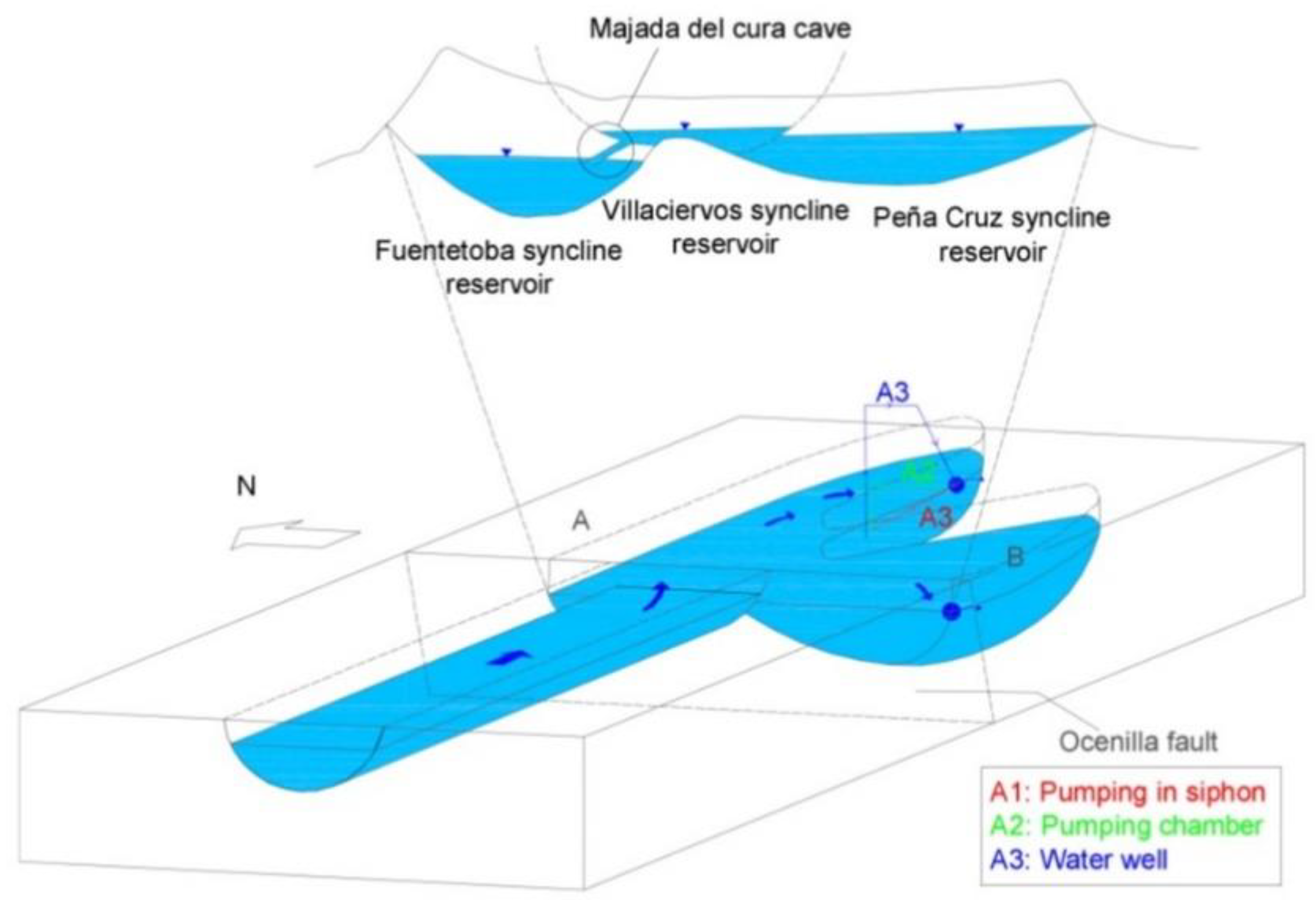
The karst system of Pico Frentes developed due to a calcareous complex of the Upper Cretaceous, of which the folded geometry is very well defined and conditioned, so that the aquifers were mainly located in three hydraulically connected synclines (schematically represented in Figure 2), with a capacity for joint underground reserves of 6 hm3. Of these permanent reserves, those of the Fuentetoba spring syncline are 3 hm3. The other two synclines (Alto de la Cruz and Villaciervos) have capacities of 1.5 hm3 each. Recharge in this unconfined aquifer and in the peneplain is autogenous and diffuse. Underground flow is driven on a large scale by the bottom of the synclines, and on a small scale by underground currents towards the Fuentetoba springs (210 L/s) and the source of the Mazos river (50 L/s), with other minor discharges arising in high waters. The Alto de la Cruz synclinal mainly drains to the source of the Mazos river. For this reason and from a practical point of view, in regulation studies we only consider the Fuentetoba and Villaciervos synclines.
Analysis of the hydrographs of these springs and speleological explorations indicated a highly variable regime system (between 8 and 3400 L/s) and little natural regulation power as a consequence of the predominant circulation of water according to a non-Darcian physical model in turbulent flow. Part of the flow is through an underground torrent in the vadose zone, and through well-developed karst ducts in the phreatic and epiphreatic zones, as reflected in speleological explorations. All these characteristics identify a typical karst aquifer with great capacity for renewal and little residence time.
Thanks to the simulation of the hydrographs of these resurgences using a mathematical model of precipitation–runoff (CREC), the average hydraulic balance for a series of 20 years was quantified in detail [9], as follows: rainfall contribution, 16.86 hm3 (100%); natural recharge, 8.35 hm3 (49.53%); evapotranspiration (EVT), 8.50 hm3 (50.41%); groundwater pumping, 0.01 hm3 (0.06%); surface runoff, 0 hm3; underground transfers to other aquifers, 0 hm3.

4. Results

4.1. Speleological Exploration Results

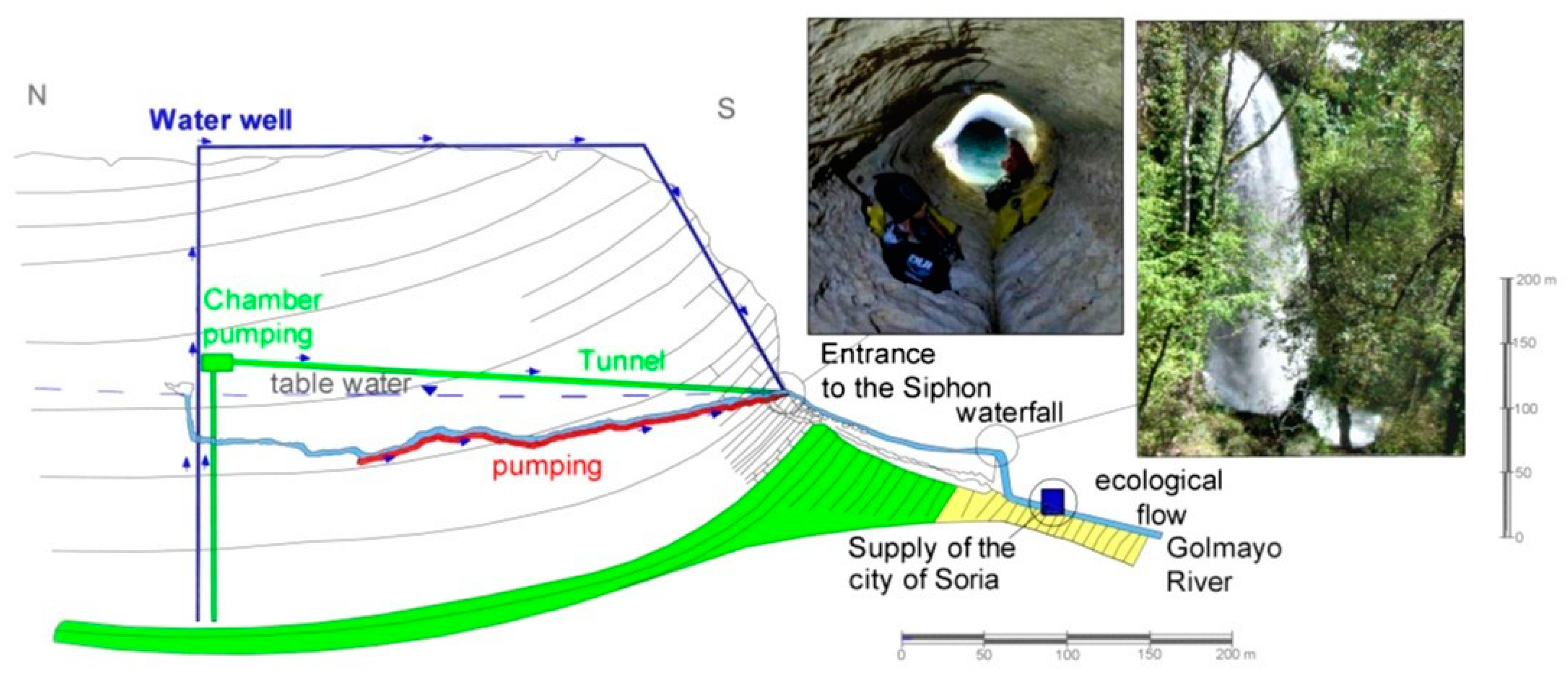
With the support of three speleological groups (Club Deportes Espeleo, Club Deportivo Terrasub, and Sociedad Espeleológica Alto Duero), it was possible to discover a well-organized karst network of caves that channels the flow towards a single spring. There are 3 km of development in the unsaturated zone [10,11] and about 400 m of conduit connected to the spring in the saturated zone (Figure 3). Thanks to these explorations and the geological structure of the area, it was possible to better understand the hydrogeological conceptual model of the aquifer. Two important aspects stood out regarding the regulation studies of the Fuentetoba spring, as follows: (1) The hydraulic communication between the synclinal furthest from the spring (Villaciervos syncline) and the Fuentetoba syncline is through an underground river that circulates through the unsaturated zone (Figure 2) [10]. This conditions the way of organizing the approach to the regulation calculations and the mathematical model. (2) In the saturated zone of the Fuentetoba syncline, groundwater flows to the main spring through a circular conduit that is 2 m in diameter, 400 m long, and 45 m deep, which channels the stored water to the center of the syncline. This conduit is certainly not the only one, and it could be used as a catchment with a pump installation to take advantage of the groundwater reserves in the upper part of the saturated zone, which is that with the largest volume (at least 2 hm3).

4.2. Numerical Model of Precipitation–Runoff to Study Fuentetoba Spring Regulation

To apply these mathematical models, it must be considered that karst aquifers like this one are characterized by a complex heterogeneity that is created and developed by groundwater flow [18].
The basic conceptual model of a karst system is represented by three different components, the epikarst, the unsaturated zone, and the saturated zone [19,20]. The epikarst usually acts as a reservoir, delaying the recharge of the karst system. Infiltrated water flows rapidly through the unsaturated zone through sinkholes or open fractures, or as a slow and diffuse flow through the matrix and small fractures in the rock. In the saturated zone, groundwater flows into the main spring through conduits, and through the matrix and small cracks. In Fuentetoba, the karst network is generally well-organized from the surface downwards, channeling the flow to a single spring. On the other hand, in karst aquifers, considerable water volumes can be stored; in the case of the Fuentetoba aquifer, reserves were estimated to be at 4.5 hm3.
The numerical model that was applied during this study, CREC [16], is based on the conceptual model of hydrogeological behavior that was discussed. This type of model was already successfully developed for several other nearby karst systems [21,22]. The model was applied to reproduce a natural recharge series over time, but it could also be used to manage aquifer water resources. Here, we present the theoretical development of the numerical model that allows for characterizing the hydrological behavior of an actively managed karstic aquifer for water supply. In [23], for example, an application of one of these models was presented for the management and regulation of the Lez spring (France).
In this model, water circulation is simulated by means of the transfer of three tanks, reservoirs, or deposits: S, H, and G. Tank S corresponds to the ground at the most superficial level of the three. This reservoir corresponds to the part of production due to precipitation in the form of snow or rain, from which evapotranspiration and surface runoff must be discounted in order to arrive at effective rain. The H deposit corresponds to the unsaturated level of the aquifer, which is responsible for the nonlinear emptying of the aquifer. Lastly, in the transfer of water through the saturated zone, we have Reservoir G, which represents the saturated level of the aquifer and is responsible for its linear emptying.
For the regulation of a spring, we assume that aquifer Deposits H and G are exploitable for the regulation of the spring. This planning was developed from the transfer of water from Reservoirs S to H.
Due to its possible pumping (Bj) in times of low water as a consequence of the consumption of water (Cj) by the Soria population, the deposit of these two reservoirs can be negative until reaching the storage capacity of the aquifer (x12), fulfilling
G j + H j > x 12
When the sum of the deposits is negative, the level of the aquifer is below the level of the Fuentetoba spring, which means that the extraction of water is then performed through pumping.
When some deposits are negative, the percolation of S in H is in charge of making these mentioned reservoirs positive. It is also considered that pumping extraction (Bj) is proportional in each of the tanks:
G j f = G j x 10 · B j
H j f = H j x 11 · B j
where
x10 + x11 = 1.
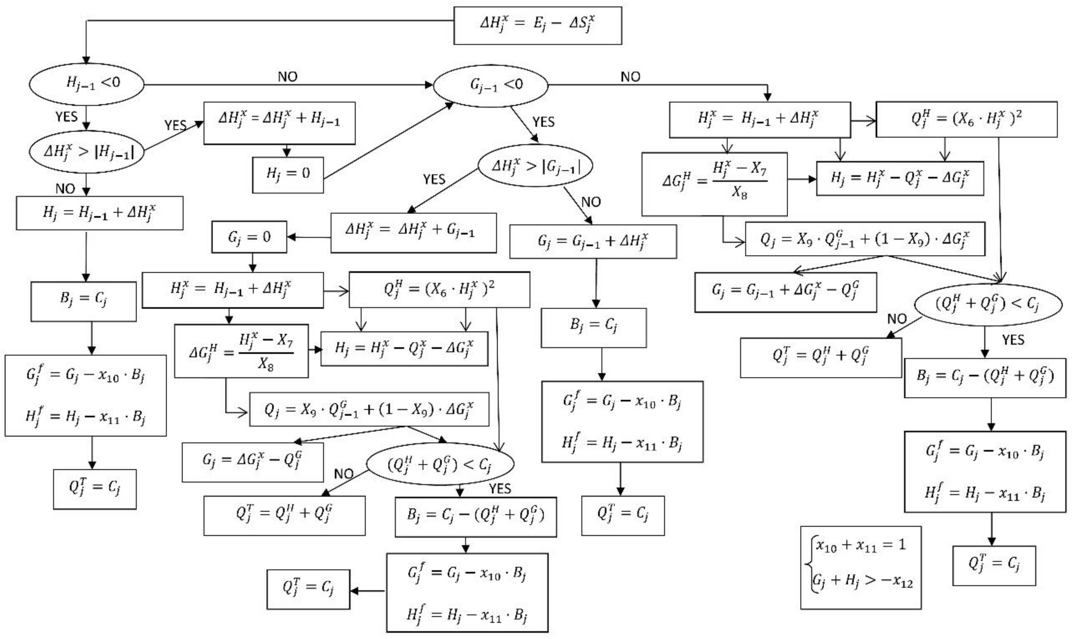
The following procedure is based on a flow system (Figure 4) consisting of the following:
  • If the level of the two reservoirs is positive, proceed as in the CREC model. If the discharge flow rate is less than water consumption (Cj), the difference is pumped, and tanks are emptied in the same proportion;
  • If Reservoir H is positive, and Reservoir G is negative, percolation from S to H is used to fill Reservoir G:
    • If Level G is positive, the difference is the new percolation from S to H and proceeds as in the CREC model. If the discharge flow rate is less than the water consumption (Cj), the difference is pumped, and tanks are emptied in the same proportion;
    • If Level G is negative, percolation from S to H is used to fill Level G, and the entire flow necessary for water consumption (Cj) is pumped (Bj).
  • If Reservoir H is negative, percolation from S to H is used to feed Reservoir H:
    • If Level H is positive, the difference is the new percolation from S to H, and proceeds as in Point 2, considering the difference between Level H and the transfer from S to H as the percolation from S to H;
    • If Level H is negative, percolation from S to H serves to fill Level H, and all necessary flow for water consumption (Cj) is pumped (Bj).
In summary, the model is shown in the following flow diagram (Figure 4).
To summarize, although these precipitation–runoff models are usually employed to reproduce historical flow series, they can also be applied to derive the effects that, in the natural regime of a spring, produce supposed recharges or discharges that occur in the aquifer. In this, it was not important if the origin of the recharge was natural (from allogenic rivers, for example) or induced (pumping or artificial recharge). Pumping could be applied to the model simply by changing the sign of the recharges.
A simplification of the CREC model for a preliminary approach can be achieved assuming that pumping or recharging is performed directly over the saturated zone, and uniform height variation of the entire water table occurs.
Given the great karstification and permeability of the Fuentetoba syncline (where pumping wells are mainly located), this theoretical assumption is close to reality. This additivity of causes and effects was developed by [24] for a SIMERO precipitation model, similar to the one used here. Furthermore, the aquifer size is small and it is possible to assume that the pumping radius of influence would affect the entire aquifer.

5. Discussion: Regulation Planning of Fuentetoba Spring for Soria Supply

5.1. Possible Regulatory Options

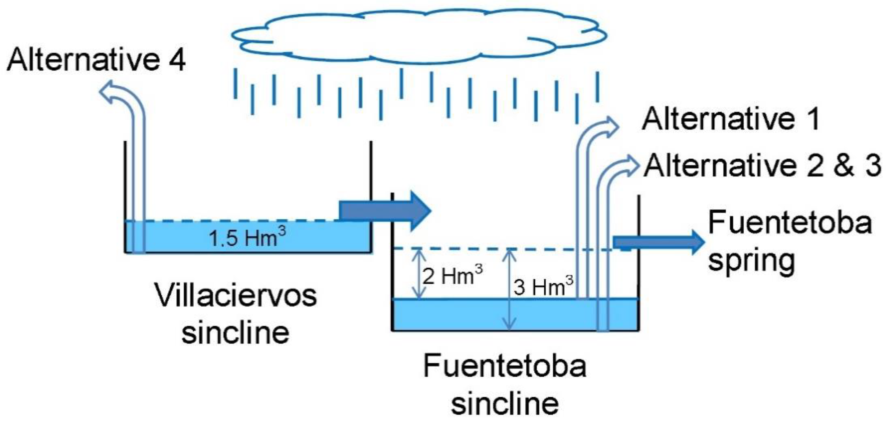
To propose viable options, the following limitations should be considered: (a) in Fuentetoba, there are no topographic possibilities to build storage reservoirs for water from aquifer pumping; (b) for the same topographical question, a borehole could only be created high on the plateau of Pico Frentes; (c) a horizontal drainage gallery equipped with a tap drilled into the bottom of the synclinal would make the waterfall disappear (solution in 1935 [4]), so was disregarded. All this led us to the following possible alternatives (Figure 5).
Option 1: Taking advantage of the high degree of aquifer karstification, proceed to guide a pipe through the siphon to its lowest point. This would consist of the installation of a submersible pump fixed to the ground and a water outlet pipe. Explorations showed cave dimensions that ensure work feasibility. The advantages of this solution are cheaper construction, and lower visual and environmental impact. However, a lower pumping volume would be managed, as it would be limited by the height of the siphon. At this height, the permanent groundwater reserves are about 2 hm3.
Option 2: The construction of a tunnel from the Fuentetoba spring waterfall to the borehole where pumping occurs is planned. The location of the tunnel entrance meets adequate working conditions. It would be necessary to excavate a small underground cavern as a pump room. Wells would also be drilled from the surface. The advantages of this option are the greater capacity to extract groundwater reserves (3 hm3), and a lower pumping cost than that in Option 3. The cost of tunnel drilling is an unfavorable aspect.
Option 3: Drilling out a borehole from the Pico Frentes plateau, fully penetrating the aquifer in the synclinal axis, and canalizing water to the waterfall there. The available permanent groundwater reserves would be as in Option 1, namely, all of Fuentetoba’s syncline resources—3 hm3. The disadvantages are the worse accessibility, and higher costs in pumping and ducts. It would also be possible to generate electrical energy after installing an electric turbine because the difference in elevation between the páramo and the waterfall is greater than 100 m.
Option 4. The collection of groundwater from the Villaciervos’ synclinal through wells until completing total permanent groundwater reserves of 4.5 hm3. Wells would be located about 4 km from the intake for supply, so conduction costs would have to be added.
In all options, the pumping time plan would be adapted to supplement 184 L/s. The pumps would start when the spring cannot discharge that quantity of water.
From an economic point of view, a first assessment of the cost of each option is presented in Ref. [25]. In Ref. [25], there is a detailed construction-cost report of each option. The very character of each option indicates a clear advantage for Option 1. Over an index of 100 (Option 1, approx. EUR 200,000), Options 2 and 3 have indices of 1200 and 1100, respectively.

5.2. Regulation Prefeasibility

In the management framework of looking to guarantee the supply and best possible use of the hydraulic resources of the area, the city of Soria (currently 35,000 inhabitants) is considering the possibility of new options. So, it is possible to consider a supply produced exclusively by the Fuentetoba spring of very high-quality water [26], following the project launched by Clemente Sáenz [7,8], with some differences. However, the great irregularity in the spring flow makes its direct catchment insufficient for Soria consumption, since it could only satisfy 33% of the days (Figure 6). Since the place does not meet the topographic conditions required to store water in ponds or reservoirs downstream of the spring, the exploitation of aquifer groundwater reserves according to the described options is proposed, that is, considering resources of 2 (Option 1), 3 (Options 2 and 3) and 4.5 hm3 (Option 4) (Figure 5).
To calculate the supply needs, an estimate of the permanent population was made following the databases of the National Institute of Statistics (INE), projecting a 2033 population of 48,358 inhabitants (by using census data of 2000–2014), and a seasonal population of 60,680 inhabitants (using data obtained from the Local Infrastructure and Facilities Survey for the periods of 2000, 2005, 2008, 2009, 2010, 2011, 2012, and 2013). A water demand of 250 L/inhab/day was estimated, and the seasonal period is between 15 June and 15 September; thus, needs of (regularly) 140 and (seasonally) 175.6 L/s were estimated. An ecological flow of about 16.5 L/s must be added since it was found that, although the spring does not fall below 8 L/s (see classified flow curve in Figure 6), the river runs dry before its mouth in the Duero river, and 10 km lower most of the year. So, we have to consider the permanent total needs of 148.5 L/s, and 184.1 L/s in seasons with the highest population.
However, and although the average flow of the Fuentetoba spring (210 L/s) is higher than the demand for water in the city of Soria (184.5 L/s), this could only be satisfied by the spring 34% of the year, so it would be necessary to supplement it with groundwater extraction from the aquifer by wells. The water catchment from the karst aquifer of Pico Frentes is a real option for the urban supply of neighborhoods that are currently in full growth in the west of Soria, a few kilometers from the spring. In addition, with the regulation of the spring and its diversion through the natural waterfall, it is possible to obtain the double benefit of solving the needs for water quality and quantity for human supply, and having a waterfall with a minimal flow of 148.5 L/s, boosting the tourist attraction and the ecological discharge of the Golmayo river throughout the year. According to the curve of classified discharges, this is only shown by the spring under a natural regime for 38% of the year (Figure 6).
For this reason, it is proposed to pump the Fuentetoba syncline during times when the flow of the spring is lower than the consumption in order to guarantee continuous supply, thus modifying the outgoing flow of the aquifer to adjust it to the real demand. The Fuentetoba syncline basin is filled at high water, which also helps to laminate avenues in the spring.
Regulation then focuses on the Fuentetoba spring aquifer, which has an average annual contribution of 4.97 hm3. This water availability is what is used to calculate the various usages. For time discretization, the month is taken as a unit both for consumption and water inputs into the aquifer. It was also simulated for a 21-year series, for which data were available. It was also assumed that this series was broad enough to be representative of spring behavior. Thus, it was possible to infer various degrees or levels of regulation. The aim was to determine the rhythms in time of outflows and inflows, and, as a consequence, the variation in the volume of underground water storage. Equality between inputs and outputs is specified in their annual average (4.97 hm3), for which a complete interannual regulation is proposed.
Table 1 presents a summary of the results of the regulation simulation using volumes of underground reserves of 2, 3, and 4 hm3. These coincide with the described options, except for the last one (4.5 hm3). It is not necessary to completely empty the Villaciervos syncline since 4 hm3 is enough for there to be no supply deficit.
Thus, using a 4 hm3 volume of reserves (Option 4), the water demands of Soria are satisfied.
However, if the used volume of reserves is 3 or 2 hm3, the volume of unattended water would be 2% or 7%, respectively. This also slightly increases the amount of water not captured by gravity.
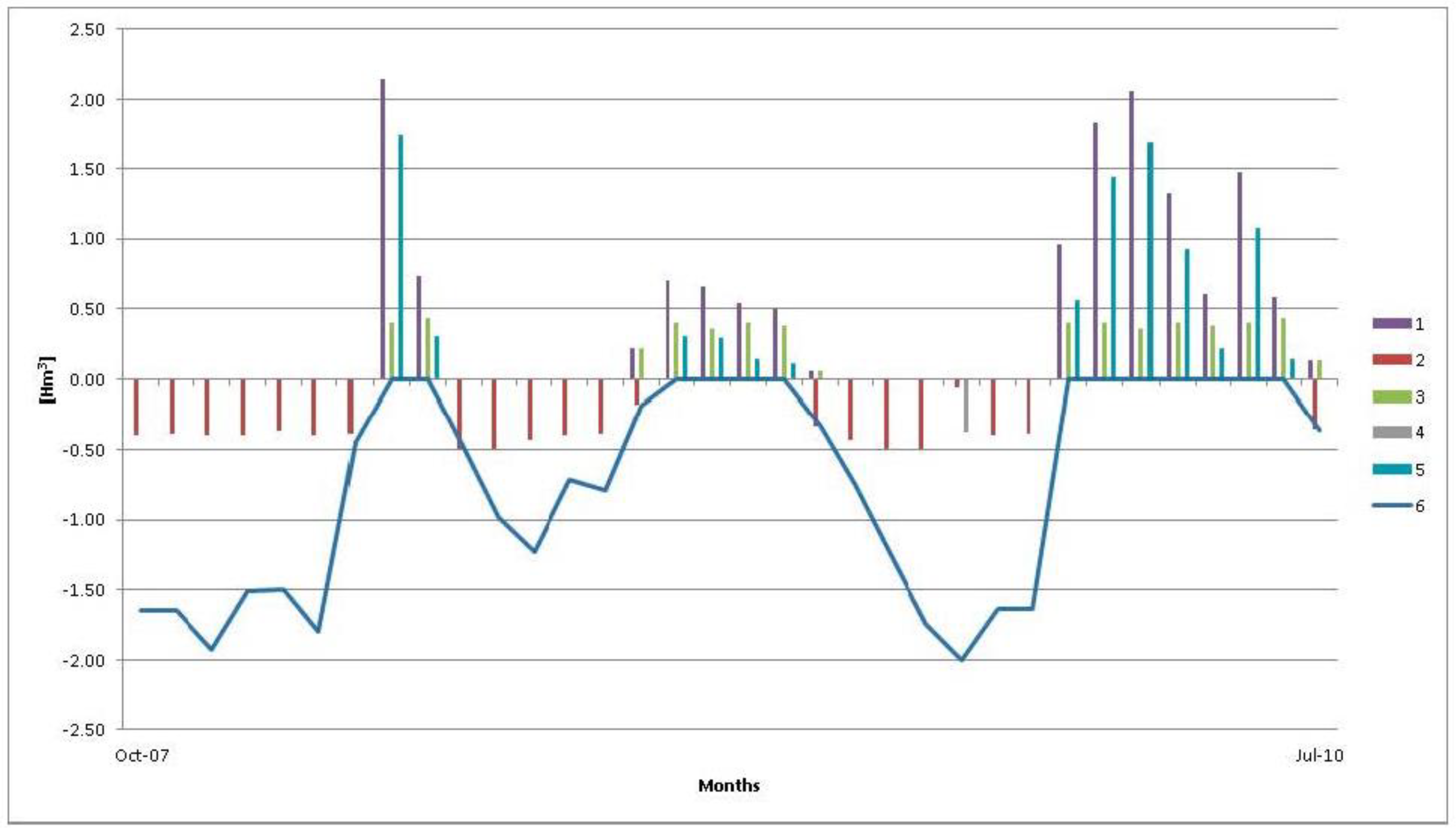
This aquifer has very active hydrodynamics, with high filling and emptying speeds. The groundwater velocity is very high, with hydrodynamic reserves emptying within one month [10]. This is reflected in Figure 7 for the example of using 2 hm3 of the underground reserves (Option 1)—inputs to the system (natural recharge) can fill the aquifer in a single month, going from a situation of deficit in supply to surplus water, and diverting it to the river. Therefore, the spring has little capacity for laminating spring avenues.
As the aquifer has a limited storage capacity for permanent reserves (4.5 hm3), its total initial emptying would not imply a significant improvement in regulation because it would quickly fill up. It is interesting to empty it each year before the rainy season to store water in the aquifer.
Figure 8 shows the classified flow curves of the surplus flows from the catchment for the supply for the three options, which are important from an ecological point of view. They are very similar to each other and guarantee that the Golmayo river runs water almost every time. In any case, the situation of the catchment point represented in Figure 3 helps to transport water by gravity to Soria. It can also be located as far downstream as desired. Of course, this would entail the cost of pumping the water into the city, but there would also be an advantage in having a permanent flow of water of at least 184 L/s along the river.
There is little difference between the different options, but it is prudent to start regulation with Option 1, which is cheaper, since a guarantee of the supply of 93% of the flow necessary to supply Soria is achieved, and it would allow for higher flow in the waterfall and river in a manner that is sustainable and harmonious with the environment. In this case, the spring would naturally contribute (without pumping) monthly discharges for the supply of 23%, thus reducing cost per pumping.

6. Conclusions

The Fuentetoba spring aquifer offers good prospects for regulation. The karst network explored in the saturated zone near the spring could be used as a pumping device. The reconstruction of a 21-year historical flow series from the spring using mathematical simulation provided the corresponding variation in natural recharge. This was used to analyze the hydraulic dynamics of inputs and outputs as a preliminary simulation of the aquifer system for the interannual regulation of the Fuentetoba spring. It also permitted us to display a numerical model that characterized the hydrological behavior of an actively managed karst for water supply. A complete and subsequent regulation project would be an example of sustainability in groundwater management, since it would give us the simultaneous opportunity to improve the water supply of Soria with better-quality water, and recover an attractive waterfall. This prefeasibility work justifies investing in the next stages.

Author Contributions

E.S. surveyed the preliminary studies, provided the original idea of the study, drafted the manuscript, and analyzed the proposed method; P.R. carried out analysis of the proposed method and model simulations; I.M.-P., conceptualization, supervision, project administration; J.S.d.O., support for modeling and visualization. All authors have read and agreed to the published version of the manuscript.

Funding

Part of the data collection of this study was financed by the Research Group of the Polytechnic University of Madrid in 2020.

Acknowledgments

We thank Carlos Morón and speleology groups Club Deportes Espeleo, Club Deportivo Terrasub, and Sociedad Espeleológica Alto Duero for the provision of the topography of the cave network for this research work.

Conflicts of Interest

The funders had no role in the design of the study; in the collection, analyses, or interpretation of data; in the writing of the manuscript, or in the decision to publish the results.

References

  1. López Bermúdez, F.; Quiñonero, J.M.; García, R.; de Valmaseda, E.M.; Sánchez Fuster, M.C.; Chocano, C.; Guerrero, F. Fuentes y Manantiales de la Cuenca del Segura. Región de Murcia; Instituto Euromediterráneo del Agua, Confederación Hidrográfica del Segura: Murcia, Spain, 2014; ISBN 978-84-92988-24-2. [Google Scholar]
  2. Kresic, N. Groundwater Resources: Sustainability, Management and Restoration; McGraw-Hill: New York, NY, USA, 2009; p. 852. [Google Scholar]
  3. Kresic, N. Types and Classifications of Springs. In Groundwater Hydrology of Springs: Engineering, Theory, Management, and Sustainability; Kresic, N., Stevanovic, Z., Eds.; Elsevier: Amsterdam, The Netherlands, 2010; pp. 31–86. [Google Scholar] [CrossRef]
  4. Kresic, N.; Stevanovic, Z. Groundwater Hydrology of Springs: Engineering, Theory, Management, and Sustainability; Elsevier: Amsterdam, The Netherlands, 2010; p. 573. [Google Scholar]
  5. Kazakis, N.; Chalikakis, K.; Mazzilli, N.; Ollivier, C.; Manakos, A.; Voudouris, K. Management and research strategies of karst aquifers in Greece: Literature overview and exemplification based on hydrodynamic modelling and vulnerability assessment of a strategic karst aquifer. Sci. Total Environ. 2018, 643, 592–609. [Google Scholar] [CrossRef] [PubMed]
  6. Manakos, S.; Ntona, M.; Kazakis, N.; Chalikakis, K. Enhanced Characterization of the Krania–Elassona Structure and Functioning Allogenic Karst Aquifer in Central Greece. Geosciences 2019, 9, 15. [Google Scholar] [CrossRef] [Green Version]
  7. Sáenz, C. La Fuente de La Toba y la Hidrología local. Proyecto de Conducción de Aguas Potables de La Toba a Soria. Mapas y Anejos; Unpublished Report; Ayuntamiento de Soria: Soria, Spain, 1935; p. 59. [Google Scholar]
  8. Sáenz, C. Pico Frentes (Partes I a V). Celtiberia 1955, 9, 245–274. [Google Scholar]
  9. Rosas, P.; Sanz, E.; Menéndez-Pidal, I. Hidrogeología del Karst de Pico Frentes (Cordillera Ibérica, España). Estud. Geológicos 2016, 72, e047. [Google Scholar] [CrossRef] [Green Version]
  10. Sanz, E.; Rosas, P.; Menéndez-Pidal, I. Drainage and siphoning of a karstic spring: A case study. J. Cave Karst Stud. 2016, 78, 183–197. [Google Scholar] [CrossRef]
  11. Fonollá, C.; Sanz, E.; Menéndez-Pidal, I. Lateral ferruginous groundwater transfer as the origin of the iron crusts in caves: A case study. J. Cave Karst Stud. 2020, 82, 183–197. [Google Scholar] [CrossRef]
  12. Jevtic, G.; Dimkic, D.; Dimkic, M.; Josipovic, J. Regulation of the Krupac spring outflow regime. In Water Resources and Environmental Problems in Karst: Cvijic Karst; Tevanovic, Z., Milanovic, P., Eds.; FMG: Belgrade, Serbia, 2005; pp. 321–326. [Google Scholar]
  13. Portier, L.; Ricour, J.; Tardieu, B. Port-Miou and Bestouan freshwater submarine spring (Cassis–France) investigations and works (1964–1978). In Water Resources and Environmental Problems in Karst: Cvijic Karst; Tevanovic, Z., Milanovic, P., Eds.; FMG: Belgrade, Serbia, 2005; pp. 267–274. [Google Scholar]
  14. Sanchez, H.; Robert, B.; Pellerin, R. A project portfolio risk–opportunity identification framework. Proj. Manag. J. 2008, 39, 97–109. [Google Scholar] [CrossRef]
  15. Ministerio para la Transición Ecológica. Gobierno de España. Legislación. Available online: https://www.miteco.gob.es/es/calidad-y-evaluacion-ambiental/legislacion/ (accessed on 20 October 2020).
  16. Guilbot, A. Modélisation des Écoulements d’un Aquifère Karstique (Liaison Pluie-Débit). Application Aux Bassins de Saugras et du Lez. Ph.D. Thesis, Université des Sciences et Techniques du Languedoc, Montpellier, France, 1975. [Google Scholar]
  17. Pérez, J.; Sanz, E. Hydrodinamic characteristics and sustainable use of karst aquifer of high environmental value in the Cabrejas range (Soria, Spain). Environ. Earth Sci. 2010, 1, 20–30. [Google Scholar] [CrossRef]
  18. Bakalowicz, M. La zone d’infiltration des aquifères karstiques. Méthodes d’étude. Structure et fonctionnement. Hydrogéologie 1995, 4, 3–21. [Google Scholar]
  19. Mangin, A. Contribution à l’étude hydrodynamique des aquifères karstiques. 3ème partie. Constitution et fonctionnement des aquifères karstiques. Ann. Spéléologie 1975, 30, 21–124. [Google Scholar]
  20. Bakalowicz, M.; Mangin, A. L’aquifère karstique. Sa définition, ses caractéristiques et son identification. Mémoire Hors Série Société Géologique Fr. 1980, 11, 71–79. [Google Scholar]
  21. Sanz, E. Les systemes karstiques des Sierras de Urbion et de Neila, Burgos, Espagne. Hydrol. Sci. J. 1996, 41, 385–398. [Google Scholar]
  22. Sanz, E. Le karst du canyon du Lobos et son fonctionnement hydrogéologique. Karstologia 1996, 28, 49–56. [Google Scholar] [CrossRef]
  23. Fleury, P.; Ladouche, B.; Conroux, Y.; Jourde, H.; Dörfliger, N. Modelling the hydrologic functions of a karst aquifer under active water management—The Lez spring. J. Hydrol. 2009, 365, 235. [Google Scholar] [CrossRef]
  24. Sanz, E. Simulation of Spring Management with Quasi-Aggregated Model. J. Hydrol. Eng. 1999, 4, 77–79. [Google Scholar] [CrossRef]
  25. García Lorenzana, M. Captación de Agua Subterránea en el Acuífero de Pico Frentes. Bachelor’s Thesis, Universidad Politécnica de Madrid, Madrid, Spain, 2016. [Google Scholar]
  26. Confederación Hidrográfica del Duero. Available online: http://www.mirame.chduero.es/DMADuero_09_Viewer/viewerShow.do;jsessionid=C0858653A78DE4AA03598E6B84E6C3F2?action=showViewer (accessed on 20 August 2020).
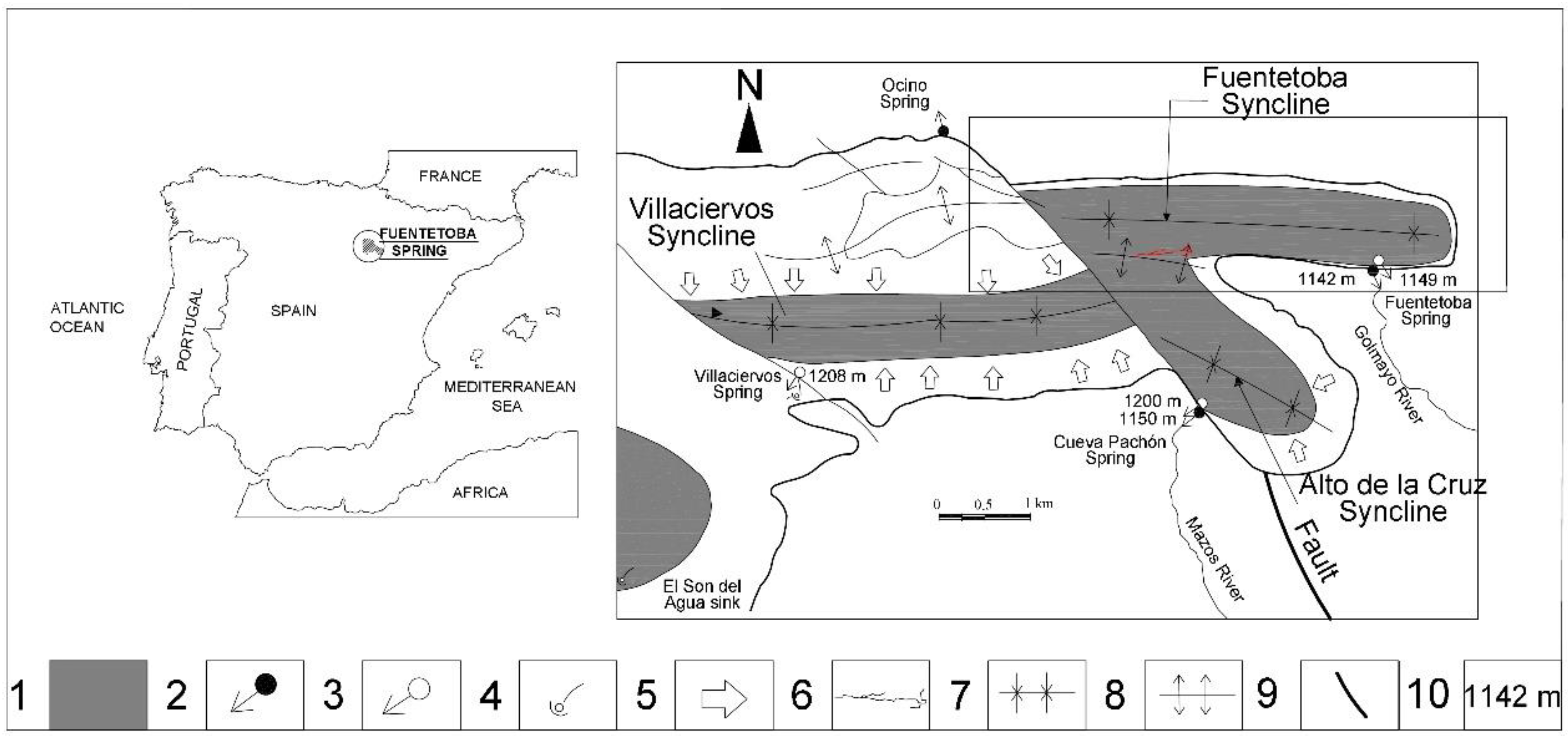
Figure 1. Location of study area. Karst system of Fuentetoba spring and source of Mazos river. 1, permanently saturated zone; 2, perennial spring; 3, intermittent spring; 4, sink; 5, groundwater flow in saturation zone periphery; 6, Majada del Cura cave; 7, syncline; 8, anticline; 9, limestone–marl contact outcrop; 10, ground level (taken from [9]).
Sustainability 12 10131 g001
Figure 2. Fuentetoba spring aquifer made up of two hydraulically connected synclines. Villaciervos syncline mainly drains through a cave (Majada del Cura) to the Fuentetoba syncline, the outlet of which is Fuentetoba spring. Alto de la Cruz syncline drains to the Mazos river source. Schematic section was drawn in the Ocenilla fault plane.
Sustainability 12 10131 g002
Figure 3. Drainage duct of Fuentetoba spring explored up to 400 m upstream of the spring, reaching up to 45 m below spring level. Photos show the dimensions of the conduit and the 20 m waterfall after its source. Three of the four considered options for the regulation of the Fuentetoba spring are indicated. Option 1 (red), pumping in submerged conduit upstream from spring and 45 m below its elevation; Option 2 (green), pumping by boreholes to syncline bottom from underground cavern and water evacuation by tunnel; Option 3 (blue), borehole pumping to syncline bottom from ground surface. To the last two, groundwater collection from the Villaciervos syncline through wells could be added (Option 4).
Sustainability 12 10131 g003
Figure 4. Planning for the integration of spring regulation in the CREC model [16].
Sustainability 12 10131 g004
Figure 5. Simplified scheme of regulation of Fuentetoba spring with indication of four options or alternatives.
Sustainability 12 10131 g005
Figure 6. Curve of classified flows of Fuentetoba spring corresponding to a 21-year series. The probability that the spring could meet Soria’s current water demand in a natural regime is only 34.53%.
Sustainability 12 10131 g006
Figure 7. Example of regulation simulation of Fuentetoba spring aquifer for exploitation of 2 hm3 of permanent groundwater reserves (Option 1). 1, Fuentetoba spring flow; 2, pumping; 3, spring water catchment; 4, water deficit for supply; 5, no captured spring discharge; 6, variation of permanent groundwater resources.
Sustainability 12 10131 g007
Figure 8. Classified flow curve of spring discharges that were not captured for supply.
Sustainability 12 10131 g008
Table 1. Distribution of total water volume (hm3) corresponding to a 21-year regulation simulation in Fuentetoba spring aquifer according to different supply options based on different volume levels of the used resources. Outlets through spring, pumping, captured by spring water gravity, spring water that is not captured, and deficit in supply are shown.
Available Groundwater Resources
(hm3)
Natural Recharge (hm3; %)Fuentetoba Spring Discharge (hm3; %)Pumping (hm3; %)Spring Water Catchment (hm3; %)Supply Deficit (hm3; %)Uncaptured Spring Discharge (hm3; %)
2 hm3
(Option 1)
150.99 (100%)84.07
(42.8%)
64.73
(42.8%)
35.71
(23.6%)
7.01
(4.6%)
48.37
(32%)
3 hm3
(Options 2 and 3)
150.99
(100%)
76.89
(51%)
73.35
(48.6%)
32.08
(21.2%)
2.02
(1.34%)
44.81
(29.6%)
4 hm3
(Option 4)
150.99
(100%)
74.91
(49.6%)
76.08
(50.4%)
31.37
(20.7%)
0.0
(0%)
43.54
(28.8%)
Publisher’s Note: MDPI stays neutral with regard to jurisdictional claims in published maps and institutional affiliations.