The Path of Petrila Mining Area towards Future Industrial Heritage Tourism Seen through the Lenses of Past and Present
Abstract
1. Introduction
2. Literature Review
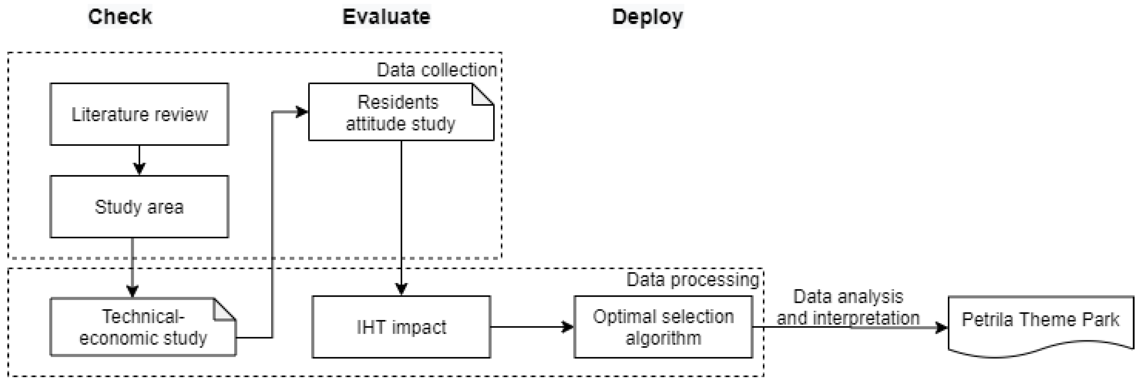
3. Materials and Methods
3.1. Study Area
3.2. Optimal Algorithm
3.3. Objective of the Algorithm
3.4. Constraints
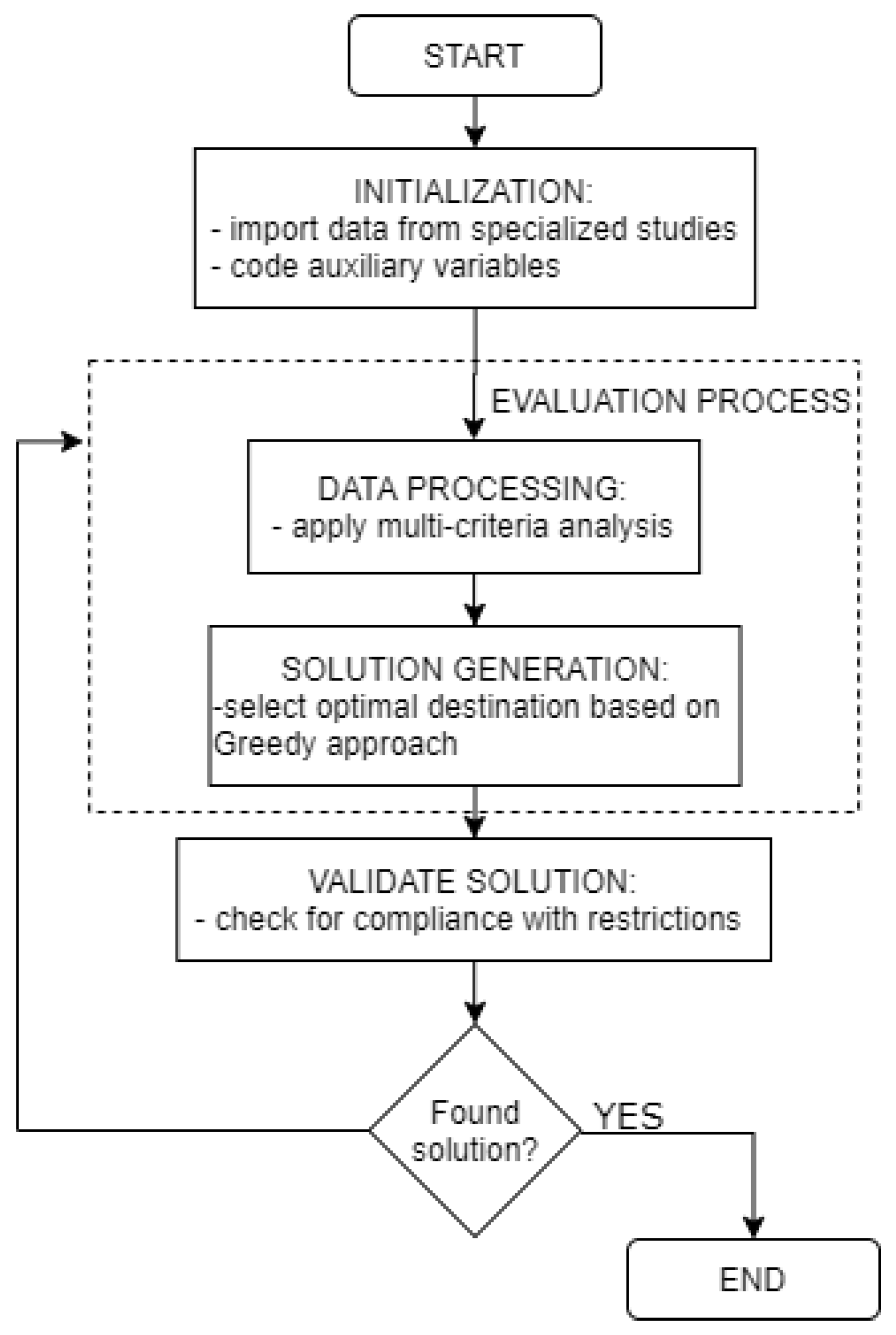
3.5. Solution Approach
3.5.1. Initialization
3.5.2. Evaluation Process
3.5.3. Validate Solution
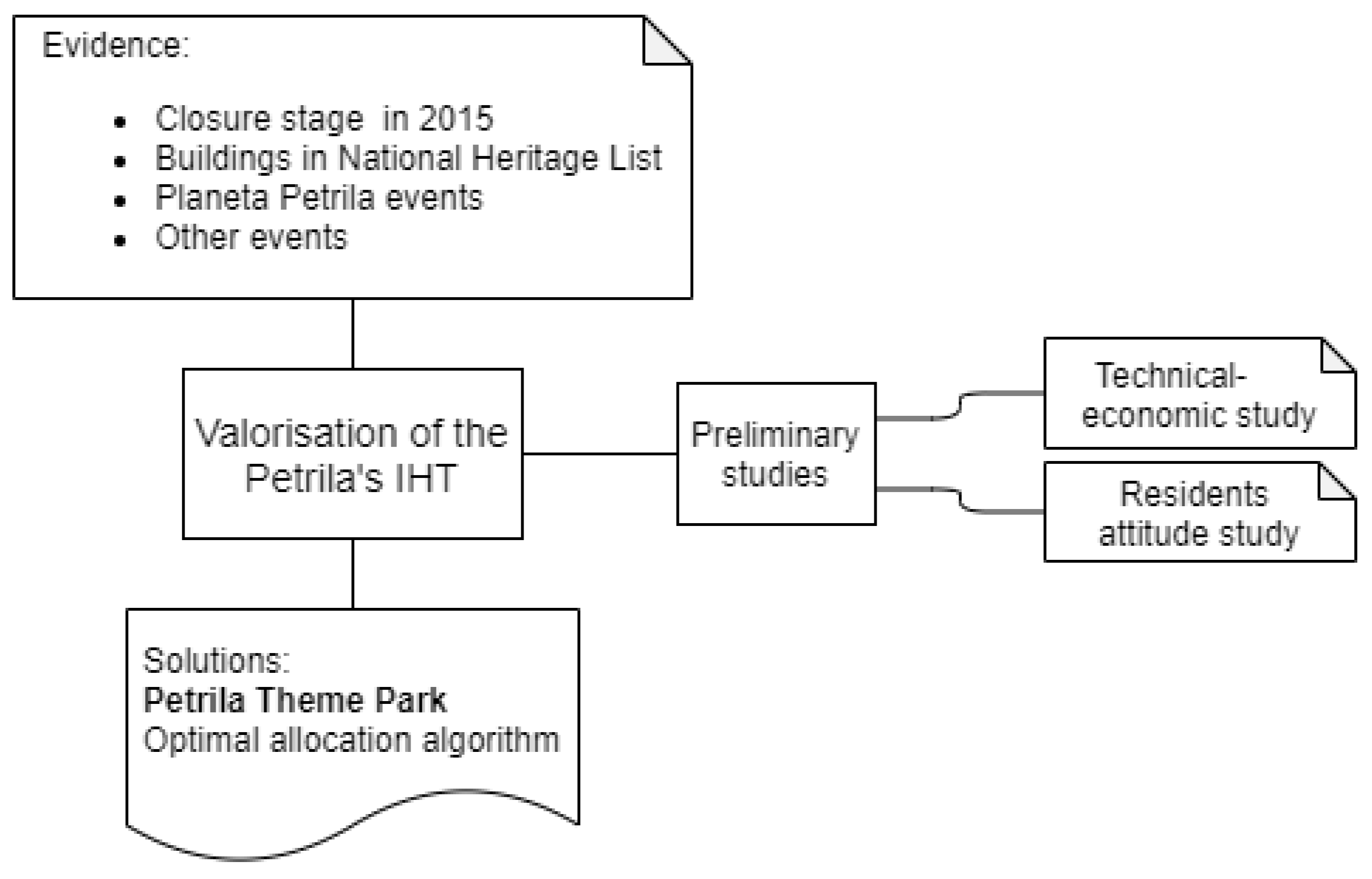
4. Valorization of the Petrila’s Post-Industrial Heritage
4.1. Preliminary Studies
4.1.1. Technical-Economic Study Regarding the Choice of Possible Destinations of the Buildings that Will Be Part of the Theme Park
4.1.2. Residents’ Attitude towards IHT Development
- there is availability to support measures for the development of tourism activities in the area, the attitude of the inhabitants towards the development of tourism being a positive one, most of the answers, 78%, being placed in the “agree” area;
- the idea of integrating the theme park in a tourist circuit generated positive feedback, the greatest openness to the idea being registered at the level of age ranges 28–37 years with 91% and 48–57 years with 89%, their answers being placed in the “total agree” area;
- regarding the positive effects to be generated by the development of tourism activities in the area, most of the respondents are of the opinion that they will not be late to appear, and place the answers in the area “total agree”—“agree” (82% regarding positive economic effects, 75% regarding positive social effects and 71% regarding positive environmental protection effects);
- the negative effects are not expected to appear according to the opinion of the majority of the surveyed population who place the most responses in the “disagree” area (82% regarding negative economic effects and 78% regarding negative social effects and 77% regarding negative environmental protection effects);
- regarding the positive feedback on the development of a theme park in the former Petrila Mine perimeter, most of the answers are placed in the “total agree” area; the respondents who are the most open-minded about this idea are in the 28–37 years age range with 83% and 48–57 years with 89%;
- the destinations of the buildings from the heritage list (in accordance with the technical solutions of consolidation and restoration) based on the preferences of the locals are presented in Table 6.
4.2. Petrila’s Industrial Heritage Case Study
5. Results
6. Discussion
7. Conclusions, Limitations and Further Research Directions
Author Contributions
Funding
Conflicts of Interest
References
- Xie, P.F. Developing industrial heritage tourism: A case study of the proposed jeep museum in Toledo, Ohio. Tour. Manag. 2006, 27, 1321–1330. [Google Scholar] [CrossRef]
- Lee, T.H.; Jan, F.-H. Can community-based tourism contribute to sustainable development? Evidence from residents’ perceptions of the sustainability. Tour. Manag. 2019, 70, 368–380. [Google Scholar] [CrossRef]
- Lee, T.H. Influence analysis of community resident support for sustainable tourism development. Tour. Manag. 2013, 34, 37–46. [Google Scholar] [CrossRef]
- Diedrich, A.; García-Buades, E. Local perceptions of tourism as indicators of destination decline. Tour. Manag. 2009, 30, 512–521. [Google Scholar] [CrossRef]
- Hunt, C.; Stronza, A. Stage-based tourism models and resident attitudes towards, tourism in an emerging destination in the developing world. J. Sustain. Tour. 2014, 22, 279–298. [Google Scholar] [CrossRef]
- Lundberg, E. The level of tourism development and resident attitudes: A comparative case study of coastal destinations. Scand. J. Hosp. Tour. 2015, 15, 266–294. [Google Scholar] [CrossRef]
- Stratton, M. Reviving industrial buildings. In Industrial Buildings: Conservation and Regeneration; Taylor & Francis: London, UK, 2000; pp. 8–29. [Google Scholar]
- Simonson, L.R. A Study of Industrial Plant Tours as Important Tourism Attractions. Ph.D. Thesis, Texas A&M University, College Station, TX, USA, 1974. [Google Scholar]
- Cox, L.J.; Fox, M. Agriculturally Based Leisure Attractions. J. Tour. Stud. 1991, 2, 18–27. [Google Scholar]
- Pearce, P.L. Farm tourism in New Zeeland: A social situation analysis. Ann. Tour. Res. 1990, 17, 337–352. [Google Scholar] [CrossRef]
- MacCannell, D. The Tourist: A New Theory of the Leisure Class; Schocken Books: New York, NY, USA, 1976. [Google Scholar]
- McBoyle, G. Industry’s Contribution to Scottish Tourism: The Example of Malt Whisky Distilleries. In Tourism: State of the Art; Seaton, A.V., Ed.; Wiley: Chichester, UK, 1994; 528p. [Google Scholar]
- Swarbrooke, J. The Development and Management of Visitors Attractions; Butterworth Heinemann: Oxford, UK, 1995. [Google Scholar]
- Macionis, N. Wine tourism in Australia. In Tourism Down Under II: Towards a More Sustainable Tourism, Proceedings of the Tourism Research Conference, Dunedin, New Zealand, 3–6 December 1996; Kearsley, G., Ed.; Centre for Tourism, University of Otago: Dunedin, New Zealand, 1996; pp. 264–286. [Google Scholar]
- Kelly, I.; Dixon, W. Sideline Tourism. J. Tour. Stud. 1991, 2, 21–28. [Google Scholar]
- Yale, P. From Tourist Attractions to Heritage Tourism; Elm Publications: Huntingdon, UK, 1991. [Google Scholar]
- Dodd, T.H.; Bigotte, V. Perceptual Differences Among Visitor Groups to Wineries. J. Travel Res. 1991, 35, 46–51. [Google Scholar] [CrossRef]
- Frew, E.A. Industrial Tourism: A Conceptual and Empirical Analysis. Ph.D. Thesis, Victoria University, Melbourne, Australia, 2000. [Google Scholar]
- Otgaar, A.H.J. Industrial Tourism: Where the public Meets the Private. Ph.D. Thesis, Erasmus University Rotterdam, Rotterdam, The Netherlands, 2010. [Google Scholar]
- Falk, N. Our Industrial Heritage: A Resource for the Future. Planner 1989, 71, 13–16. [Google Scholar]
- Hewison, R. Heritage Interpretation: The Natural and Built Environment. In The Heritage Industry: Social Representation of Heritage Interpretation; Uzzell, D., Ed.; Belhaven: London, UK, 1989; Volume 1, pp. 15–23. [Google Scholar]
- Briggs, C.S. Welsh Industrial Heritage: A Review; CBA Research Report No. 79; Council for British Archaeology: London, UK, 1992. [Google Scholar]
- Prentice, R.C. Tourism and Heritage Attractions; Routledge: London, UK, 1993. [Google Scholar]
- Harris, F. From the industrial revolution to the heritage industry. Geogr. Mag. 1989, 61, 38–42. [Google Scholar]
- Olgethorpe, M. Tourism and industrial Scotland. Tour. Manag. 1987, 8, 268–271. [Google Scholar]
- Kerstetter, D.; Confer, J.J.; Bricker, K.S. Industrial Heritage Attractions: Types and Tourists. J. Travel Tour. Mark. 1998, 7, 91–104. [Google Scholar] [CrossRef]
- Edwards, J.A.; Coit, J.C.L.I. Mines and quarries: Industrial heritage tourism. Ann. Tour. Res. 1996, 23, 341–363. [Google Scholar] [CrossRef]
- Summerby-Murray, R. Interpreting deindustrialised landscapes of Atlantic Canada. Can. Geogr./Le Geographe Can. 2002, 46, 48–62. [Google Scholar] [CrossRef]
- Firth, T.M. Tourism as a means to industrial heritage conservation: Achilles heel or saving grace? J. Herit. Tour. 2011, 6, 45–62. [Google Scholar] [CrossRef]
- Caffyn, A.; Lutz, J. Developing the heritage tourism product in multi-ethnic cities. Tour. Manag. 1999, 20, 213–221. [Google Scholar] [CrossRef]
- Halewood, C.; Hannam, K. Viking heritage tourism: Authenticity and commodification. Ann. Tour. Res. 2001, 28, 565–580. [Google Scholar] [CrossRef]
- Oevermann, H.; Degenkolb, J.; Dießler, A.; Karge, S.; Peltz, U. Participation in the reuse of industrial heritage sites: The case of Oberschöneweide, Berlin. Int. J. Herit. Stud. 2016, 22, 43–58. [Google Scholar] [CrossRef]
- Steinecke, A. Kulturtourismus in der Erlebnisgesellschaft: Trends, Strategien, Erfolgsfaktoren. Geogr. Sch. 2002, 24, 10–12. [Google Scholar]
- Soyez, D. Industrietourismus. Erdkunde 1986, 40, 105–111. [Google Scholar] [CrossRef]
- Mader, T. Produzierende Betriebe als Touristische Attraktionen im Reuhrgebiet: Grundlagen, Erscheinungsformen, Probleme. Master’s Thesis, Heinrich-Heine Universitate, Dusseldorf, Germany, 2003. [Google Scholar]
- Armis, R.; Kanegae, H. The attractiveness of a post-mining city as a tourist destination from the perspective of visitors: A study of Sawahlunto old coal mining town in Indonesia, Asia-Pacific. J. Reg. Sci. 2019, 4, 443–461. [Google Scholar] [CrossRef]
- Chhabra, D.; Healy, R.; Sills, E. Staged Authenticity and Heritage Tourism. Ann. Tour. Res. 2003, 30, 702–719. [Google Scholar] [CrossRef]
- Lee, T.J.; Riley, M.; Hampton, M.P. Conflict and progress: Tourism development in Korea. Ann. Tour. Res. 2010, 37, 355–376. [Google Scholar] [CrossRef]
- Vargas-Sánchez, A. Industrial Heritage and Tourism: A Review of the Literature. In The Palgrave Handbook of Contemporary Heritage Research; Palgrave Macmillan: London, UK, 2015; pp. 219–222. [Google Scholar]
- Yang, X. Industrial heritage tourism development and city image reconstruction in Chinese traditional industrial cities: A web content analysis. J. Herit. Tour. 2017, 12, 267–280. [Google Scholar] [CrossRef]
- Park, E.; Choi, B.K.; Lee, T.J. The role and dimensions of authenticity in heritage tourism. Tour. Manag. 2019, 74, 99–109. [Google Scholar] [CrossRef]
- Adongo, R.; Choe, J.Y.; Han, H. Tourism in Hoi An, Vietnam: Impacts, perceived benefits, community attachment and support for tourism development. Int. J. Tour. Sci. 2017, 7, 86–106. [Google Scholar] [CrossRef]
- Ka Leong, D.C. Heritage or hesitate? Preserving authenticity in Hong Kong tourism. Int. J. Tour. Sci. 2016, 16, 191–202. [Google Scholar] [CrossRef]
- Bryce, D.; Curran, R.; O’Gorman, K.; Taheri, B. Visitors’ engagement and authenticity: Japanese heritage consumption. Tour. Manag. 2015, 46, 571–581. [Google Scholar] [CrossRef]
- Kolar, T.; Zabkar, V. A consumer–based model of authenticity: An oxymoron o the foundation of cultural heritage marketing? Tour. Manag. 2010, 31, 652–664. [Google Scholar] [CrossRef]
- Xie, P.; Wall, G. Visitors’ Perceptions of Authenticity at Cultural Attractions in Hainan, China. Int. J. Tour. Res. 2002, 4, 353–366. [Google Scholar] [CrossRef]
- Zhou, Q.; Zhang, J.; Zhang, H.; Li, X. Is all authenticity accepted by tourists and residents? The concept, dimensions and formation mechanism of negative authenticity. Tour. Manag. 2018, 67, 59–70. [Google Scholar] [CrossRef]
- Cantell, S.F. The Adaptive Reuse of Historic Industrial Buildings: Regulation Barriers, Best Practices and Case Studies. Master’s Thesis, Virginia Polytechnic Institute and State University, Blacksburg, VA, USA, 2015. [Google Scholar]
- Association “Valea Jiului Development Society Project”, Valea Jiului Implicata. Available online: https://www.valeajiuluiimplicata.org/tag/coalitia-vaii-jiului-implicata/ (accessed on 23 September 2020).
- Toderaş, M. Rock Mechanics, Soil and Underground Constructions. Ph.D. Thesis, Universitas Publishing House, Petrosani, Romania, 2014; pp. 1–1167. (In Romanian). [Google Scholar]
- Caamaño-Franco, I.; Andrade-Suárez, M.M. The Value Assessment and Planning of Industrial Mining Heritage as a Tourism Attraction: The Case of Las Médulas Cultural Space. Land 2020, 9, 404. [Google Scholar] [CrossRef]
- Gursoy, D.; Jurowski, C.; Uysal, M. Resident Attitudes—A Structural Modelling Approach. Ann. Tour. Res. 2002, 29, 79–105. [Google Scholar] [CrossRef]
- Hoffman, D.L.; Low, S.A. An Application of the Probit Transformation to Tourism Survey Data. J. Travel Res. 1981, 20, 35–38. [Google Scholar] [CrossRef]
- Sheldon, P.J.; Var, T. Resident Attitudes to Tourism in North Wales. Tour. Manag. 1984, 5, 40–47. [Google Scholar] [CrossRef]
- Ritchie, B.W.; Inkari, A. Host Community Attitudes Toward Tourism and Cultural Tourism Development: The Case of the Lewes District, Southern England. Int. J. Tour. Res. 2006, 8, 27–44. [Google Scholar] [CrossRef]
- Andrade-Suárez, M.; Caamaño-Franco, I.I. The Relationship between Industrial Heritage, Wine Tourism, and Sustainability: A Case of Local Community Perspective. Sustainability 2020, 12, 7453. [Google Scholar] [CrossRef]
- Xie, P.F.; Lee, M.Y.; Wong, J. Assessing community attitudes toward industrial heritage tourism development. J. Tour. Cult. Chang. 2019, 18, 237–251. [Google Scholar] [CrossRef]
- Butler, R.W. The concept of a tourism areas cycles of evaluation: Implications for management of resources. Can. Geogr./Le Geographe Can. 1980, 24, 5–12. [Google Scholar] [CrossRef]
- Levi-Strauss, C. The Elementary Structures of Kinship; Lippit, R., Polanski, N., Rosen, S., Eds.; Beacon Press: Boston, MA, USA, 1969. [Google Scholar]
- Homans, G.C. Social Behaviour: Its Elementary Forms; Harcourt, Brace & World, Inc.: New York, NY, USA, 1961. [Google Scholar]
- Blau, P.M. Exchange and Power in Social Life; Wiley: New York, NY, USA, 1964. [Google Scholar]
- Emerson, R. Power-Dependence Relations. Am. Sociol. Rev. 1972, 27, 38–87. [Google Scholar]
- Ko, D.W.; Stewart, W.P. A structural equation model of residents’ attitudes for tourism development. Tour. Manag. 2002, 23, 521–530. [Google Scholar] [CrossRef]
- Vargas-Sanchez, A.; Porras-Bueno, N. Understanding Residents’ Attitudes toward the Development of Industrial Tourism in a Former Mining Community. J. Travel Res. 2008, 47, 373–387. [Google Scholar] [CrossRef]
- Samuil, I.; Ionică, A.C.; Leba, M.; Noaghi, S.; Rocha, A. Towards a Business Model for Post-industrial Tourism Development in Jiu Valley, Romania. In Proceedings of the 8th World Conference on Information Systems and Technologies (WorldCist’20), Budva, Montenegro, 7–10 April 2020. AISC 1159. [Google Scholar]
- Toderas, M.; Samuil, I.; Ionica, A.; Olar, M.; Militaru, S. Aspects regarding a mining area rehabilitation for post-industrial tourism. In MATEC Web of Conferences, Proceedings of the 9th International Conference on Manufacturing Science and Education—MSE 2019: Trends in New Industrial Revolution, Section Environment Engineering, Sibiu, Romania, 5–7 June 2019; Curran Associates, Inc.: Red Hook, NY, USA, 2019. [Google Scholar]
- Pawinski, G.; Sapiecha, K. Cost-efficient project management based on critical chain method with partial availability of resources. Control Cybern. 2014, 43, 95–109. [Google Scholar]
- Deniziak, S. Cost-efficient synthesis of multiprocessor heterogeneous systems. Control Cybern. 2004, 33, 341–355. [Google Scholar]
- Douglas, A.M. A modified greedy algorithm for the task assignment problem. Master’s Thesis, University of Louisville, Louisville, KY, USA, 2007. [Google Scholar]
- Leiper, N. Tourist attraction systems. Ann. Tour. Res. 1990, 17, 367–384. [Google Scholar] [CrossRef]
- Tsai, C.Y.; Chung, S.H. A personalized route recommendation service for theme parks using RFID information and tourist behavior. Decis. Support Syst. 2012, 52, 514–527. [Google Scholar] [CrossRef]
- Souffriau, W.; Vansteenwegen, P.; Vertommen, J.; Berghe, G.V.; Oudheusden, D.V. A personalized tourist trip design algorithm for mobile tourist guides. Appl. Artif. Intell. 2008, 22, 964–985. [Google Scholar] [CrossRef]
- Vansteenwegen, P.; Van Oudheusden, D. The mobile tourist guide: An OR opportunity. OR Insight 2007, 20, 21–27. [Google Scholar] [CrossRef]
- Abdul-Rahman, S.; Benjamin, A.; Bakar, E.E.A. Economic tour package model using heuristic. AIP Conf. Proc. 2014, 1605, 1160–1165. [Google Scholar]
- Benjamin, A.M.; Abdullah, A.S.; Abdul-Rahman, S.; Nazri1, E.M.; Yahaya, H.Z. Developing a Comprehensive Tour Package Using an Improved Greedy Algorithm with Tourist Preferences. J. Sustain. Sci. Manag. 2019, 14, 106–117. [Google Scholar]
- Ghozali, A.E.; Setiawan, B.D.; Furqon, M.T. Tourism Planning Application in Malang with Greedy Algorithm (in Indonesia). J. Pengemb. Teknol. Inf. Ilmu Komput. 2017, 1, 1459–1467. [Google Scholar]
- Hashim, Z.; Desa, W.L.H.M.; Aziz, H.A.; Zaki, N.M.Z.M. Greedy Method for Solving the Langkawi Tourist Route: A Case Study. J. Technol. Oper. Manag. 2018, 13, 18–25. [Google Scholar]







| 1855 | The first geological explorations in Jiu Valley | |
| 1859 | Petrila is officially the first mining perimeter in the Jiu Valley and the deepest coal mine in Europe | |
| The extensive industrialization process of the second half of the communist period has led to significant flows of migration to the mining cities of the Jiu Valley, with an obvious impact on the population growth | ||
| 1989 | 60,679 employees in the extractive industry | |
| The massive restructuring followed by the mine closure; negatively affected both the number of inhabitants and the number of employees in the extractive industry | ||
| 2017 | 3767 employees in the extractive industry | |
| 2030 | Scenarios | |
| I. inaction scenario | III. development of the primary, secondary and tertiary sectors in the period 2020–2030 | |
| II. modernization of one of the mines and the gradual closure of four others by 2030 | ||
| Name | Data Type | Dimension | Description |
|---|---|---|---|
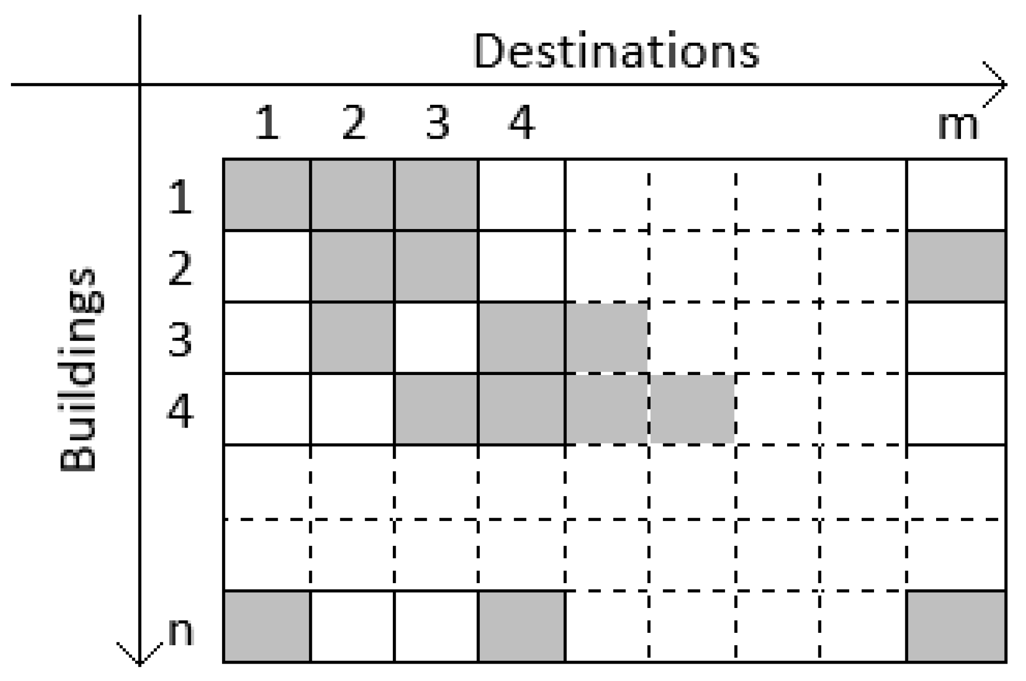
| n | Integer/Input | Scalar | Number of buildings |
| m | Integer/Input | Scalar | Number of possible destinations for the buildings |
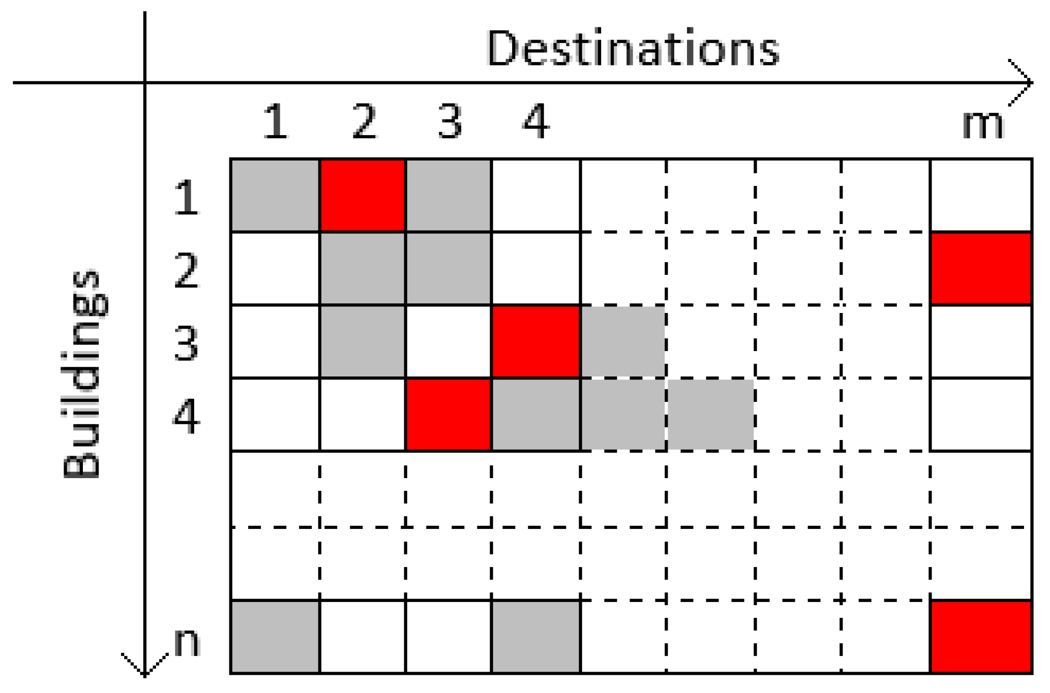
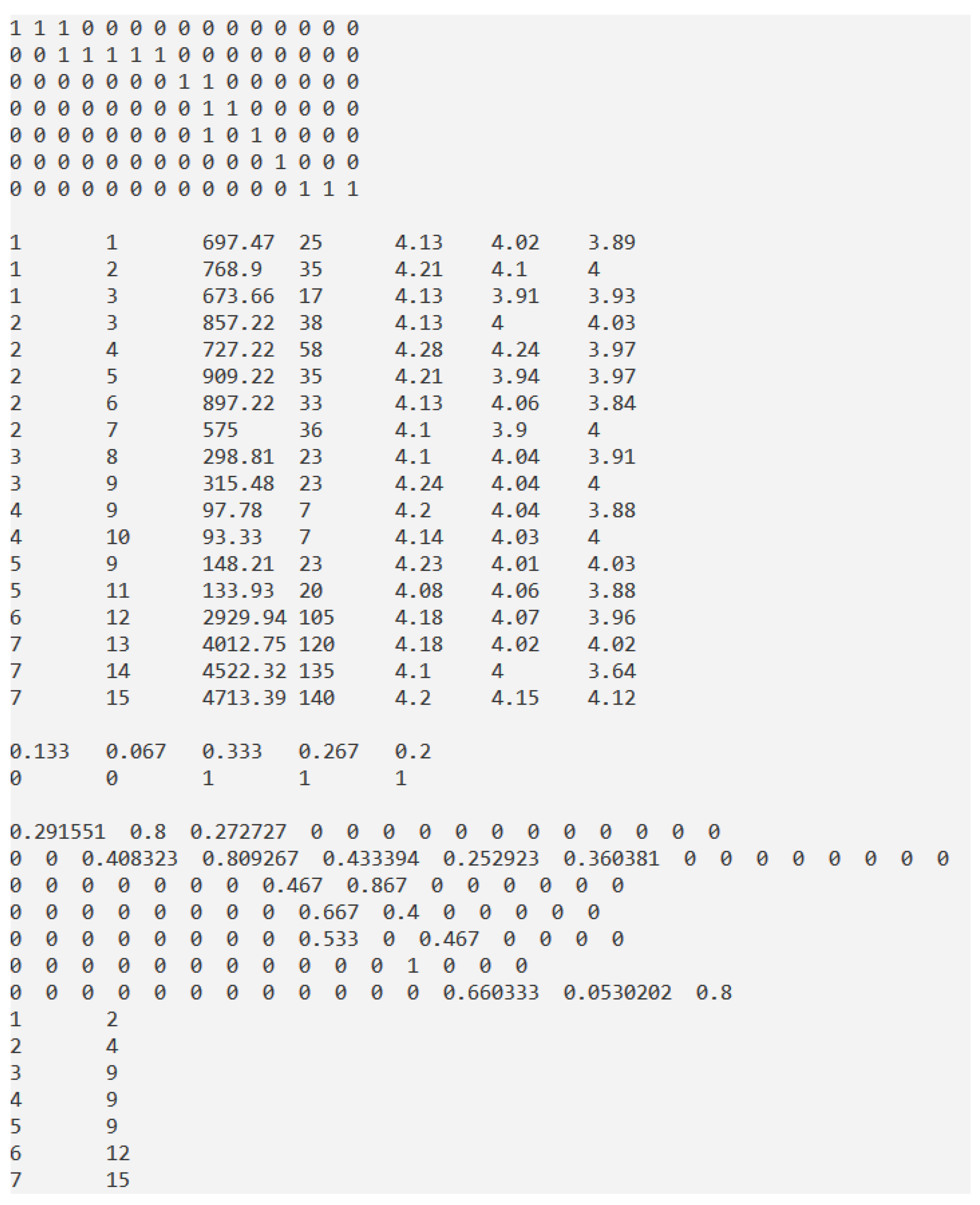
| CD | Integer (bool)/Input | n × m | Matrix of correspondences between buildings and destinations |
| UG | Real/Input and Computed | nUG × (3 + nCrit) | Matrix of multicriteria selection |
| nUG | Integer/Computed | Scalar | Number of lines in UG |
| CD_UG | Real/Computed | n × m | Support matrix |
| Coef | Real/Input | nCrit | Importance coefficients for each criterium |
| Crit | Integer (bool)/Input | nCrit | Criterium type |
| nCrit | Integer/Input | Scalar | Number of criteria |
| nCon | Integer/Input | Scalar | Number of constraints for solution |
| P | Real/Output | n × (2 + nCon) | Solution matrix |
| Existing Buildings | Symbol | Destination | Symbol | Required Works | Outgoing (Euro) | Area (m2) | Unit Costs (Euro/m2) | Time (Days) |
|---|---|---|---|---|---|---|---|---|
| Dispensary | B1 | Exhibition/presentation space | D1 | consolidation | 21,000 | 51 | 411.76 | 5 |
| redevelopment | 60,000 | 210 | 285.71 | 20 | ||||
| Cafeteria | D2 | consolidation | 21,000 | 51 | 411.76 | 5 | ||
| redevelopment | 75,000 | 210 | 357.14 | 30 | ||||
| Shop | D3 | consolidation | 21,000 | 51 | 411.76 | 5 | ||
| redevelopment | 55,000 | 210 | 261.9 | 12 | ||||
| Main building (current administrative space) | B2 | Entertainment space | D4 | consolidation | 85,000 | 180 | 472.22 | 10 |
| redevelopment | 510,000 | 2000 | 255 | 48 | ||||
| Shop/store | D3 | consolidation | 85,000 | 180 | 472.22 | 10 | ||
| redevelopment | 770,000 | 2000 | 385 | 28 | ||||
| Restaurant | D5 | consolidation | 85,000 | 180 | 472.22 | 10 | ||
| redevelopment | 874,000 | 2000 | 437 | 25 | ||||
| Cinema | D6 | consolidation | 85,000 | 180 | 472.22 | 10 | ||
| redevelopment | 850,000 | 2000 | 425 | 23 | ||||
| Museum | D7 | consolidation | 45,000 | 180 | 250 | 10 | ||
| redevelopment | 650,000 | 2000 | 325 | 26 | ||||
| Building near the school mine | B3 | Conference room | D8 | consolidation | 20,000 | 105 | 190.48 | 9 |
| redevelopment | 65,000 | 600 | 108.33 | 14 | ||||
| Education space | D9 | consolidation | 20,000 | 105 | 190.48 | 9 | ||
| redevelopment | 75,000 | 600 | 125 | 14 | ||||
| School Mine | B4 | Mine museum | D10 | redevelopment | 42,000 | 450 | 93.33 | 7 |
| Education space | D9 | redevelopment | 44,000 | 450 | 97.78 | 7 | ||
| Mechanical workshop | B5 | Mechanical workshop museum | D11 | consolidation | 39,000 | 560 | 69.64 | 8 |
| redevelopment | 90,000 | 1400 | 64.29 | 12 | ||||
| Education space | D9 | consolidation | 39,000 | 560 | 69.64 | 8 | ||
| redevelopment | 110,000 | 1400 | 78.57 | 15 | ||||
| Shaft with Skip | B6 | Shaft with Skip museum | D12 | consolidation | 160,000 | 157 | 1019.11 | 25 |
| redevelopment | 1,500,000 | 785 | 1910.83 | 80 | ||||
| Center shaft with tower | B7 | Centre Shaft museum | D13 | consolidation | 190,000 | 157 | 1210.2 | 30 |
| redevelopment | 2,200,000 | 785 | 2802.55 | 90 | ||||
| Centre Shaft museum + restaurant | D14 | consolidation | 190,000 | 157 | 1210.2 | 30 | ||
| redevelopment | 2,600,000 | 785 | 3312.12 | 105 | ||||
| Centre Shaft museum + education space | D15 | consolidation | 190,000 | 157 | 1210.2 | 30 | ||
| redevelopment | 2,750,000 | 785 | 3503.19 | 110 |
| Hypotheses | Relationships between Variables | Correlations | ||
|---|---|---|---|---|
| H1 | IBTD | < ----- > | PETD | 0.766 (**) |
| H2 | IBTD | < ----- > | GSC | 0.511 (**) |
| H3 | IBTD | < ----- > | NETD | −0.086 (***) |
| H4 | IBTD | < ----- > | IATD | 0.769 (**) |
| H5 | PETD | < ----- > | IATD | 0.866 (**) |
| H6 | PETD | < ----- > | GSC | 0.646 (**) |
| H7 | GSC | < ----- > | IATD | 0.857 (**) |
| H8 | NETD | < ----- > | GSC | 0.031 (***) |
| H9 | NETD | < ----- > | IATD | 0.229 (***) |
| Hypotheses | Relationships between Variables | Confirmed/Rejected | ||
|---|---|---|---|---|
| H1 | IBTD | (+) | PETD | Confirmed |
| H2 | IBTD | (+) | GSC | Confirmed |
| H3 | IBTD | (-) | NETD | Rejected (*) |
| H4 | IBTD | (-) | IATD | Rejected (*) |
| H5 | PETD | (+) | IATD | Confirmed |
| H6 | PETD | (+) | GSC | Confirmed |
| H7 | GSC | (+) | IATD | Rejected (*) |
| H8 | NETD | (-) | GSC | Rejected (*) |
| H9 | NETD | (+) | IATD | Rejected (**) |
| Building | Destination | Symbol | Preferences | Positive Effects | ||
|---|---|---|---|---|---|---|
| Economic | Social | Environment Protection | ||||
| Dispensary (Medical Office) | Exhibition/presentation space | D1 | 423 (31%) | 4.13 | 4.02 | 3.89 |
| Cafeteria | D2 | 567 (40%) | 4.21 | 4.10 | 4 | |
| Store | D3 | 414 (29%) | 4.13 | 3.91 | 3.93 | |
| Main building (Current administrative building) | Entertainment space | D4 | 261 (19%) | 4.28 | 4.24 | 3.97 |
| Store | D3 | 360 (26%) | 4.13 | 4 | 4.03 | |
| Restaurant | D5 | 306 (22%) | 4.21 | 3.94 | 3.97 | |
| Cinema | D6 | 288 (20%) | 4.13 | 4.06 | 3.84 | |
| Museum | D7 | 189 (13%) | 4.10 | 3.90 | 4 | |
| Building near the school mine | Conference room | D8 | 729 (52%) | 4.10 | 4.04 | 3.91 |
| Education space | D9 | 675 (48%) | 4.24 | 4.04 | 4 | |
| The school mine | Mine museum | D10 | 954 (68%) | 4.14 | 4.03 | 4 |
| Education space | D9 | 450 (32%) | 4.20 | 4.04 | 3.88 | |
| Mechanical workshop | Mechanical workshop museum | D11 | 585 (42%) | 4.08 | 4.06 | 3.88 |
| Education space | D9 | 828 (58%) | 4.23 | 4.01 | 4.03 | |
| Shaft with skip | Shaft with Skip museum | D12 | 1404 (100%) | 4.18 | 4.07 | 3.96 |
| Centre shaft with tower | Centre Shaft museum | D13 | 513 (36%) | 4.18 | 4.02 | 4.02 |
| Centre Shaft museum + restaurant | D14 | 522 (38%) | 4.10 | 4 | 3.64 | |
| Centre Shaft museum + education space | D15 | 369 (26%) | 4.20 | 4.15 | 4.12 | |
Publisher’s Note: MDPI stays neutral with regard to jurisdictional claims in published maps and institutional affiliations. |
© 2020 by the authors. Licensee MDPI, Basel, Switzerland. This article is an open access article distributed under the terms and conditions of the Creative Commons Attribution (CC BY) license (http://creativecommons.org/licenses/by/4.0/).
Share and Cite
Ionica, A.; Samuil, I.; Leba, M.; Toderas, M. The Path of Petrila Mining Area towards Future Industrial Heritage Tourism Seen through the Lenses of Past and Present. Sustainability 2020, 12, 9922. https://doi.org/10.3390/su12239922
Ionica A, Samuil I, Leba M, Toderas M. The Path of Petrila Mining Area towards Future Industrial Heritage Tourism Seen through the Lenses of Past and Present. Sustainability. 2020; 12(23):9922. https://doi.org/10.3390/su12239922
Chicago/Turabian StyleIonica, Andreea, Ionela Samuil, Monica Leba, and Mihaela Toderas. 2020. "The Path of Petrila Mining Area towards Future Industrial Heritage Tourism Seen through the Lenses of Past and Present" Sustainability 12, no. 23: 9922. https://doi.org/10.3390/su12239922
APA StyleIonica, A., Samuil, I., Leba, M., & Toderas, M. (2020). The Path of Petrila Mining Area towards Future Industrial Heritage Tourism Seen through the Lenses of Past and Present. Sustainability, 12(23), 9922. https://doi.org/10.3390/su12239922


