1. Introduction
Private cars are the dominant travel mode in the cities of Iran and these cities suffer from high vehicle traffic congestion and lack of route infrastructure to support daily growing numbers of vehicles. At the same time, walking as an active mode of travel is important as a sustainable mode of transport. According to the ecological model, walking is influenced by a variety of factors including socio-economic factors, built environment, and others [
1].
Travel behavior studies have demonstrated the link between the built environment and walking as an active mode of travel [
2,
3,
4,
5,
6,
7,
8] (
Section 2.1). These studies mostly focused on macro scale related factors (the scale of neighborhood and bigger), such as density and diversity, and rarely studied the impacts of design related factors, such as the impact of quality of the pedestrian environment on walking for transport [
9,
10]. For instance, Southworth [
11] stated that urban design has rarely been an integral part of transport planning and numerous research studies in different contexts are required to understand and generalize the role of design factors on promoting walking for transport. In addition, some of these studies investigated the use of walking based on certain types of origin/destinations; for instance, walking to/from work, school and shopping [
12], but less attention has been paid to the impact of the type of origin/destination on walking behavior.
In addition to transport studies, which have examined walking as an active mode of travel, the impact of built environment attributes on walking was more broadly investigated in studies on physical activity and public health, which considered walking as one of the most common types of daily physical activity (
Section 2.2). The majority of these studies considered walking based on its purpose, whether walking for recreation and/or utilitarian walking (walking for transport). According to these studies, the built environment attributes influencing walking for transport include neighborhood walkability score, functional aspects, such as the presence of sidewalks, residential density, land use mix–access, street connectivity, traffic safety, and personal security [
13,
14,
15,
16,
17]. In regards to the context of this study, Bahrainy et al. [
18] found that transport walking is only influenced by the steepness of sidewalks. In addition, the contribution of attitudes toward walking as associated with walking for transport was indicated by previous studies [
12,
19]. Most of these studies—which are involved with the impacts of design and aesthetic related factors on walking behavior—have used perceptual assessment of environmental attributes. For instance, Smith [
20] found that perceptions have slightly higher explanatory power than objective measures, especially in relation to aesthetic attributes in models of walking behavior. This shows the importance of perceptual assessment in design related factors with regards to walking for transport.
The metro system started to work in the city of Shiraz a few years ago to reduce the traffic congestion of the transport system. The short pathways between rail transit stations, such as metro stations, and their adjacent land uses are the areas that people use to walk in during their daily transport; and, thus, would contribute to maintaining the minimum rate of physical activity and, therefore, inhabitants’ general health. In addition, the influence of environmental factors on walking behavior around the metro stations has been studied in detail in a western context, but generally it has been rarely studied in the context of developing nations and Iran. This situation confirms the importance of the surrounding areas of metro stations in highlighting the contribution of environmental attributes, especially perceived design related attributes to walking behavior both to and from the rail transit stations. Previous studies indicated that shorter time, as well as distance, is the first path choice criteria of pedestrians in these areas [
21]. These studies also showed the contribution of built environment features such as safety, mixed land use, street connectivity, and urban design qualities, such as legibility of the pedestrians’ path choice in parallel to the contribution of shorter time and distance [
21,
22,
23,
24] (
Section 2.3). Due to the importance of walking attitudes and walking with others in relation to walking behavior, these factors are also considered in this research.
Furthermore, regarding the importance of time and distance for path choice and walking behavior, it is important to understand how far the pedestrians walk to and from the metro stations. Agrawal et al. [
21] found that Americans walked an average of half a mile to the rail stations. Moreover, Sun et al. [
24] found that the walking time from the metro station to a destination was 8 min in the context of China. Generally, the average walking distance has been rarely surveyed in the context of developing nations and Iran; thus, there is a need for it to be examined in this context.
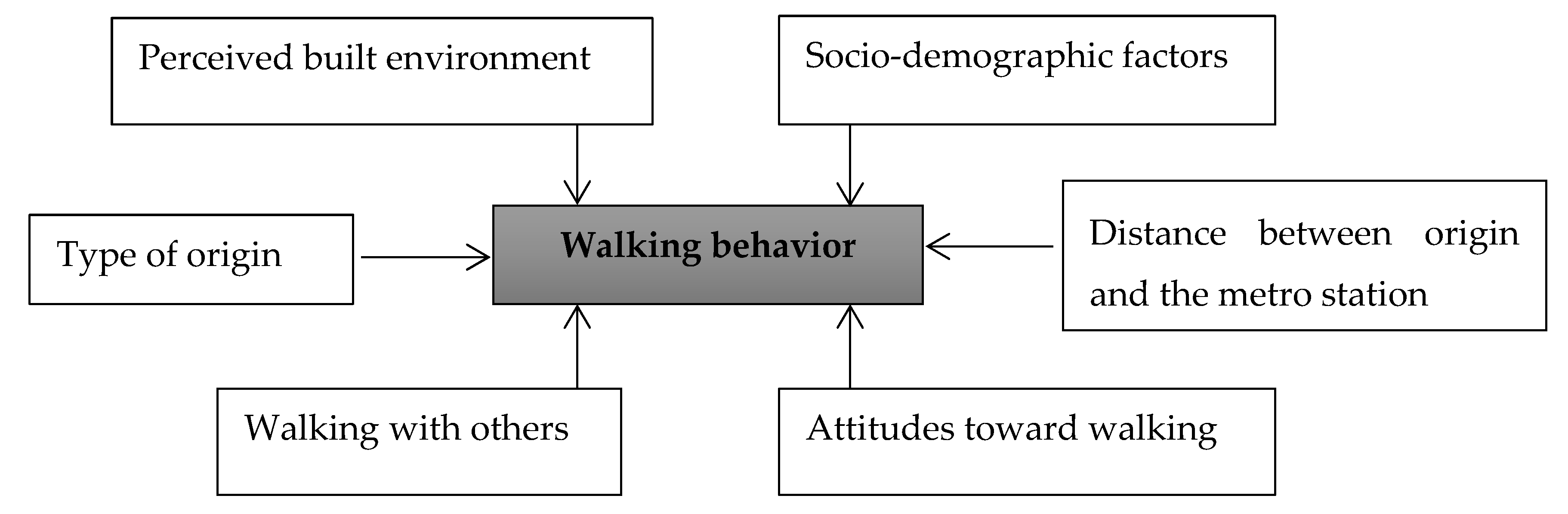
Accordingly, this study examines the impact of sociodemographic factors, perceived built environment, walking attitudes, and walking with others on walking for transport to reach the metro stations in Shiraz, Iran. In addition, the average walking distance to metro stations is measured as well. The conceptual framework of this research is shown in
Figure 1. The questions of this research are as follows:
Do the sociodemographic factors, walking attitudes, perceived built environment, distance between origin and destination, and walking with others, contribute to walking for transport to reach the metro station?
Does the type of starting points in the walking trips to reach the metro stations influence the walking behavior?
What is the average walking distance to reach the metro stations in this city?
3. Materials and Methods
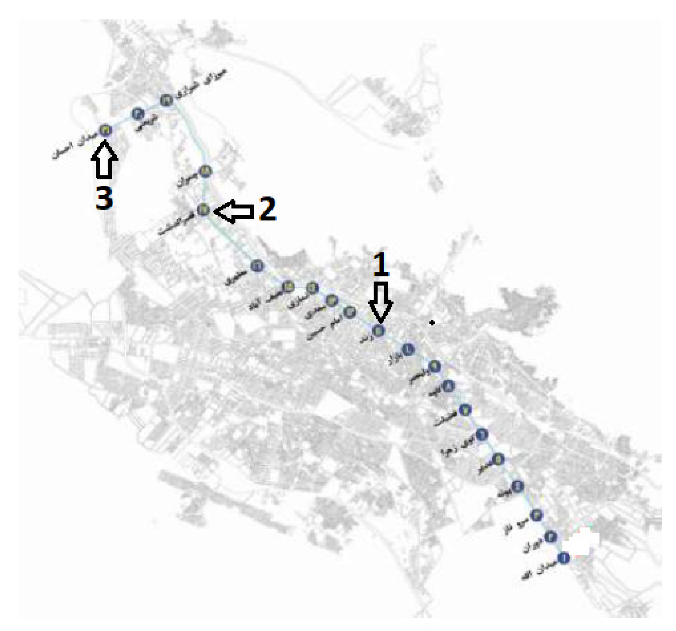
Shiraz is a historic city with a temperate climate that has evolved during different periods. It is generally made up of three distinct parts, including the central business district (CBD), the subcenter districts, and the inner-suburban areas. The metro system of Shiraz has a total of six lines out of which four lines are under construction and line 1, being the main line, was constructed and came into operation some years ago (
Figure 2). This line connects Ehsan metro station to Allah Square station.
Two criteria were used to select the metro stations for this study (
Table 1). Firstly, due to considering the built environment and origin land uses of walking trips, related to walking behavior in this study, the types of urban texture around the metro stations in terms of the factors influencing walking behavior, including land use diversity, block density, and intersection density, were studied and classified (
Table 1). In regards to the land use diversity, this study evaluates seven types, including residential, commercial and services, parks and green spaces, educational, public (health and sport), cultural-religious, and industrial land uses. By identifying and categorizing types of urban texture around all the metro stations of the city (radius of 700 m from the stations), we tried to include all types of identified urban textures in the final selected stations as much as possible (
Table 1). This is especially necessary since the findings of the study are to be generalized to all the metro stations’ surrounding areas in the city. The second criterion was the selection of the metro stations based on the comparative numbers of pedestrians trying to reach them (
Table 1). In fact, regarding the focus of the study on walking behavior around the metro stations, they were to be selected in a way that shows the high level of people who walk to reach them. In this regard, the walking levels of pedestrians in all of the metro stations were observed, and those with the highest level of pedestrians’ walking to reach the metro stations were selected (
Table 1). Based on these criteria, three metro stations—Zandiyeh metro station in zone 2 of Shiraz Municipality, Ghasrodasht metro station in zone 1 of Shiraz municipality, and Ehsan metro station in zone 6 of Shiraz municipality—were selected (
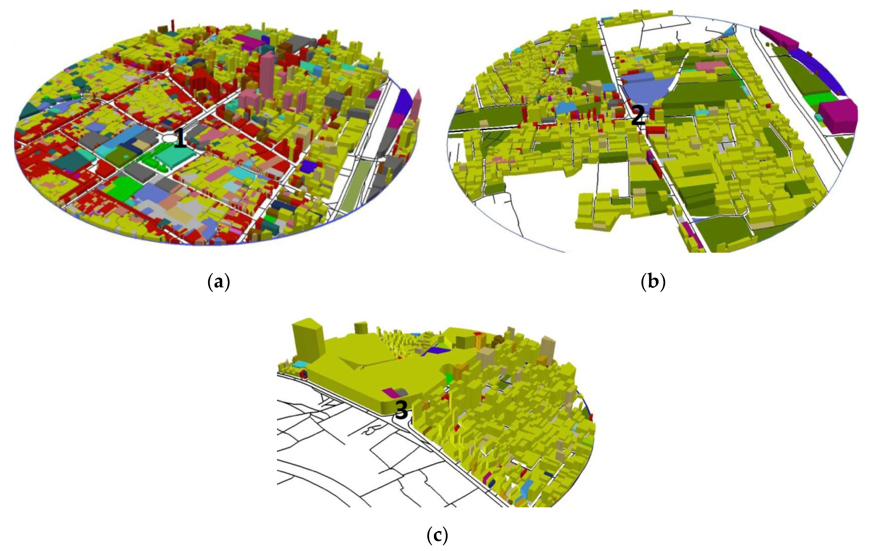
Figure 2). The surrounding areas of these metro stations are shown in
Figure 3. In these figures, the locations of the metro stations are indicated by numbers 1, 2, and 3.
A sample of 395 people was selected through considering the total numbers of train passengers who entered the selected metro stations during one week based on the Cochran formula.
Table 2 shows the number of pedestrians who entered each of the selected metro stations and the determined number of respondents for each station. The respondents were selected based on the metro stations where they arrived. Then, if they agreed to participate in the study, they were followed by the research team until their destinations on the train so that the questionnaires were completed in the presence of the research team. The respondents were also over 16 years of age and a mixture of male and female. To examine the real distance of the respondents’ walk to the metro stations, they were asked to clarify the starting point and the routes and sidewalks that they took to reach the metro stations. In cases where it was difficult to trace the information on a map, the research team helped to carry it out with the assistance of the respondents. Then, the walking routes of the respondents were transferred to GIS and the metric distance of each walking trip was measured.
A survey questionnaire was used to measure the sociodemographic factors, perceived built environment attributes, level of walking with others, walking attitudes, and level of walking to the metro station on a 5-point Likert scale (from 1 = strongly disagree, to 5 = strongly agree). Neighborhood Environment Walkability Scale (NEWS) was used to measure the built environment attributes [
51]. Selected items were modified to make them more applicable to the context of this city. In fact, they were revised according to the design attributes and qualities presented in the context. For instance, certain questions regarding path context and design qualities were added and some questions were omitted due to the absence of measurable factors in the context. The content validity of the survey questionnaire was examined by some experts in the field after the modifications made based on the feedback.
Perceived built environment characteristics were measured for traffic safety, personal security, functional aspects of walking, aesthetic aspects of walking environment, accessibility, and certain urban design qualities related to the context, such as legibility and enclosure. Walking attitudes were measured using a 5-item scale extracted from previous studies in the field [
52,
53]. In addition, the International Physical Activity Questionnaire (IPAQ) was used as the basis for measuring the level of walking of respondents to the selected metro stations [
38]. In the survey questionnaire, respondents were asked to mention the number of walking trips they made during the last 7 days to the selected metro stations and the estimated time (minutes) taken for each walking trip. Finally, in regards to the question on types of starting point, the prominent types of land use taken from the maps of the selected areas were analyzed to be used for the different categories. The respondents were also asked to clarify the nature of their destination after leaving the metro stations.
SPSS software version 23.0 was used to analyze the data. To measure the questionnaire’s reliability Cronbach’s Alpha was used. The Cronbach’s Alpha reliability coefficient was 0.902, which shows a high level of questionnaire reliability. Confirmatory factor analysis was used to identify the latent factors behind the groups of items, which measured the environmental attributes. In addition, to enter the types of starting point as the nominal variable in the regression analysis, it was transformed to several dummy variables. Finally, to predict a dependent variable from the independent variables, multiple regression analysis was applied and it was adjusted for sociodemographic variables as potential confounders.
4. Results
Table 3 shows the descriptive analysis of the indigenous and exogenous variables along with the study areas. In regards to socioeconomic characteristics, most of the respondents (65.3%) are between 19 to 29 years old. Most of the respondents are male (62.5%) as compared to female (37.5%). Likewise, most of the respondents are among a low-income group since 58% of the respondents receive less than ten million Rials. The majority of the respondents (73.4%) do not have private cars and most of them graduated with a Bachelor’s degree (41.3%). The majority of the types of starting point are from educational land uses: schools, colleges, and universities (37%), followed by offices (18.7%) and houses (16.5%). Likewise, most of the destination types after leaving the metro stations are dedicated to educational land uses (29.6%) followed by houses (15.6%) and commercial land uses (15.6%). This shows that transport trips to/from educational land uses are the main type for pedestrians who walk to/from the metro stations in this city. In addition, most of the respondents walk with others (66.6%). Moreover, finally the average mean of the inclusive items of the walking attitudes (3.92) shows that a majority of the respondents have the tendency to walk.
Confirmatory factor analysis was used to identify the latent factors behind groups of items, which measured the environmental attributes. (Maximum likelihood, 63.73% variance explained, KMO = 593). As a result of this process, nine main perceived environmental factors were identified: (1) “Aesthetic, comfort, and convenience aspects”; (2) “Traffic safety”; (3) “Functional aspects and facilities along the path (physical comfort)”; (4) “Accessibility to shops and public transport (convenient environment)”; (5) “Personal security”; (6) “ Continuity of walking movement together with sense of comfort”; (7) “The width of the sidewalks”; (8) Legibility along the path; and (9) “Enclosure along the street” (see
Table 4). Almost all the new factors and their inclusive items except the factor of “Aesthetic, comfort, and convenience aspects” follow the constructions of the factors used in the previous studies and the Neighborhood Environment Walkability Scale (NEWS), which was used as the basis to measure the perceived environmental factors in this research. “Aesthetic, comfort, and convenience aspects” includes the items that show the aesthetic attributes, including attractive natural sights and buildings, variety of views and litter free paths, a comfort aspect including the shade from trees and buildings, and three convenience aspects including presence of alternative walking routes, presence of parks as well as other recreational areas and possibility of seeing human activities inside the buildings. This new factor is interesting, as it combines several aesthetic, comfort, and convenience aspects of walking environment. This shows the similar functions of these attributes in regards to walking for transport. These factors and their inclusive items are shown in
Table 4.
Table 5 shows the results of the multiple regression analysis. The results indicate that the model is adequate to explain the relationship. R2 (0.336) shows that the independent variables of this study exhibit an explicative power of almost 0.336 to predict the dependent variable (walking behavior). In this regard, the sociodemographic factors, including monthly income (β = −0.143,
p = 0.002) and owning private cars (β = 0.190,
p = 0.000) showed significant correlations with walking behavior. The respondents with more monthly income walk less and those who do not have private cars walk more in the selected areas.
Walking attitudes showed the highest significant positive correlation with walking behavior from among the independent variables of this study (β = 0.289, p = 0.000). In addition, the distance between starting points and metro stations showed a significant negative correlation with walking behavior (β = −0.185, p = 0.000). Indeed, people with more positive attitudes toward walking walk more, and less distance between starting points and metro stations also contributes to more walking by pedestrians.
Housing type was determined as the basis in the process of transforming the origin types to dummy variables. It was found that people walk significantly more from the housing type when it is compared with the educational types of starting point (β = −0.122, p = 0.05). The other types of destinations did not show a significant contribution to walking behavior when compared to the housing types of starting points.
In regards to the impact of perceived environmental attributes on walking behavior, aesthetic, comfort, and convenience aspects (β = 0.111, p = 0.05), traffic safety (β = 0.120, p = 0.01), and personal security (β = 0.101, p = 0.05) showed significant positive correlations with walking behavior. These associations show that the increases/decreases in these environmental attributes contribute to an increase/decrease in walking behavior in the selected areas.
Finally,
Table 6 shows the metric distance between the starting points and the metro stations. According to this table, the mean of the metric distance between the starting point and the metro stations is 336 m. The minimum distance is 14 m and the maximum distance is 1598 m. The majority of the walking trips are less than 700 m in which the numbers of walking trips significantly decrease for more than 700 m distance between starting points and the metro stations.
5. Discussion and Conclusions
People with lower monthly income walk more to the metro stations. This finding is consistent with the previous studies mentioning that lower household income was associated with more walking for transport and vice versa [
54,
55]. In addition, people who have private cars walk less when compared to those who do not have a private car. This finding is also consistent with the finding of previous studies, which found that people with lower car ownership walk more for transport [
6,
38,
56]. This finding shows that in such a city, with a high level of private cars and traffic congestion, policy makers need to focus on decreasing the level of car ownership in order to strengthen walking behavior.
As expected in consistency with other studies’ findings, distance showed a significant negative correlation with the walking level of the respondents [
21]. People walk more frequently over a shorter walking distance and vice versa. The average walking distance in this context is 336 m. This is apparently less than the average walking distance in developed countries. For instance, the average walking distance to rail stations is half a mile (805 m) in the US [
21] and to other destinations in San Francisco and other cities of the US it is from 548–600 m up to 1100–1200 m in a few cases [
48,
50]. This shows that people normally walk less in this context. Transport policy makers need to work on improving the average walking level in this city with certain motivational programs promoting active travel. Such programs would contribute to a gradual shift away from private cars to a more active mode of transport and solve the problem of traffic congestion in this city. Moreover, walking attitudes were found by this research to have a significant impact on walking for transport. This is supported by the results of previous studies [
12,
19].
This research found a significant positive correlation between the factor of “aesthetic, comfort, and convenience aspects of the walking environment” with walking for transport. The subcriteria of this perceived factor are indeed classified into three categories of aesthetic aspects, including attractiveness of natural sights and buildings, variety of views, litter free paths, and transparency of facade; comfort aspect including shading by trees and buildings and convenient aspects made by presence of alternative routes and presence of parks. In terms of the availability of alternative routes as one of the convenience aspects, the finding of this study supports previous studies, which found an association between street connectivity and walking for transport [
25,
27,
30,
31]. Likewise, shade as a comfort aspect of walking supports the results of previous studies on the necessity of climatic and thermal comfort in relation to pedestrians’ movement in an urban setting [
57,
58,
59]. This finding is also justified by the hot climate of this city, which raises the importance of thermal and climatic comfort in public places.
In terms of other convenience aspects, including accessibility to parks as found in this research, previous studies found the association between accessible destination types, such as workplaces, shops, services, and public transport and walking for transport [
3,
27,
30,
31,
35]. Moreover, to our knowledge, these studies did not find an association between recreational types of destinations, such as parks, and walking for transport.
Likewise, in regards to aesthetic attributes of the walkways, our finding is contrary to findings of other studies. While the contribution of aesthetic attributes to walking for recreation has been broadly demonstrated by previous studies [
12,
31,
37,
60,
61], previous studies have rarely mentioned the association between aesthetic attributes and walking for transport [
39]. Indeed, according to the relevant studies there is a low association of aesthetic attributes such as attractiveness of views and natural landscape with walking to/from the transit stations [
21].
The findings of these aesthetic and recreational aspects in regards to walking for transport in this study are the novelties of this research and may be related to certain cultural aspects in this city. The city of Shiraz is famous as the cultural capital of Iran. Many world famous poets have lived in this city and people of this city have paid much attention to the cultural and recreational aspects of their lives. In this regard, the aesthetic attributes and the convenience aspects, such as access to parks, play a role in the level of walking toward the metro stations. In such a context, people tend to take shorter daily walking trips and the average walking distance is less than the global average, improvement of such aesthetic and recreational attributes along the sidewalks contributes to an increase in the level of walking.
In addition, the significant correlation between traffic safety and walking behavior as it was found in this research is strongly supported by previous studies [
14,
15,
21,
31,
37,
39]. The priority in the transport system of this city has been given to private cars and street development and not pedestrian movement. Private high-speed cars are observed in different types of streets even in the local alleys. That is why little attention has been given to improve the pedestrian crossings in this city. In addition, there is a lack of traffic calming devices such as speed humps, traffic lights for pedestrians, and crosswalks and they are only found at the main junctions. Moreover, motorcycles sometimes use sidewalks to bypass the traffic congestion. This was included as a safety related indicator in this study. This situation contributes to the emergence of traffic safety as the main concern of pedestrians, especially while crossing the streets. Moreover, this is the main reason for traffic safety as a factor with a significant positive correlation with walking for transport. The safety related criteria included in this research need to be improved to enhance walking around the metro stations. Moreover, this improvement in traffic safety also requires training drivers to respect pedestrians, which means working on certain cultural and educational aspects in relation to the transport system. It is the duty of transport policy makers to concentrate on such aspects.
Furthermore, personal security showed a significant positive correlation with walking behavior. Personal security includes factors such as visual connectivity between buildings and their adjacent public places, the number of people on the sidewalks, and sufficient illumination of sidewalks. This finding supports the results of previous studies, which found a correlation between personal security and walking for transport [
31,
62]. It can be inferred that the main reason for personal security as a significant factor is due to a high level of crime density especially in the surrounding areas of one of the selected metro stations called Zandiyeh, which is located in the center of the city [
63]. The studies on criminology indicated a higher crime density in the city centers [
64]. According to studies on criminology, the presence of people impacts dynamic surveillance, and the possibility of controlling public places from buildings impacts stationary surveillance. The theory of defensible space of Newman [
65] supports the necessity for stationary surveillance and the theory of virtual community of Hillier [
66] supports the necessity for dynamic surveillance. Thus, both these types of surveillance have been shown to be related to personal security and were, therefore, included in this study. Moreover, the contribution of lighting to personal security has been indicated by previous studies as well [
67,
68,
69]. Finally, our observation also led us to mention that the lighting situation around the metro stations is not suitable. Thus, it should be improved around the metro stations. This should, therefore, be improved in order to enhance personal security and walking behavior around the metro stations.
One of the novelties of this research was the consideration of the influence of the starting points on walking behavior. Previous studies examined walking behavior based on certain types of starting point/destination; for instance, walking to/from work, school, and shopping [
12], but less attention has been paid to the impact of the type of starting point/destination on walking behavior.
Among different types of starting point, only the combination of housing type versus educational type showed a significant contribution to walking behavior. People walk significantly more from the housing type when compared with educational types of starting point. Land use diversity was one of the subcriteria in choosing the metro stations, and the metro stations were selected in a way to encompass all types of stations in terms of land use diversity. Thus, the selected metro stations are representative of the whole existing metro stations in terms of land use diversity. In this regard, this result could be expanded to all the existing metro stations in this city. This result shows that the compositions of housing and educational types of starting point contribute to walking for transport. Educational types are the most common type of starting points in the selected areas (37%) followed by recreational (18.7%) and housing types (65%). Furthermore, considering the types of destination after leaving the metro station showed that educational type destinations is the most frequent destination type (29.6%) followed by housing type (15.6%). Moreover, the sum of these two types of land use covers 45.2% of the total types of destination. This shows that the trips between educational land uses (school, college and university) and housing are the most common type of transport trips to/from the metro stations in this city. Moreover, people walk more from housing types to metro stations in the compositions of these two types of land uses in the selected areas. Considering that most of the data collection time was during the morning, one interpretation is that the students are more energetic when they start their morning walking trips toward the metro stations from their home. Moreover, this gives them a motivation to walk more. The contribution of types of starting point towards walking for transport could be further investigated by future studies to give a better picture of such interrelationships.
It was stated that people walked more over shorter walking distances. In addition, the average walking distance to the metro stations found in this research is less than the average in other developed countries, such as the United States. Thus, it needs to be significantly improved. On the other hand, the contributions of several sociodemographic factors as well as psychological and environmental attributes to walking for transport were found in this study. The policy makers of this city could apply the findings of this study especially in the walking environment around the metro stations in order to improve the walking behavior and increase the average walking distances to/from the metro stations.


