Historic Environmental Vulnerability Evaluation of Traditional Villages Under Geological Hazards and Influencing Factors of Adaptive Capacity: A District-Level Analysis of Lishui, China


Abstract
:1. Introduction
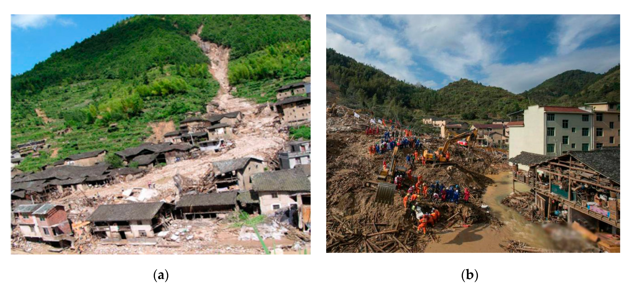
1.1. Background
1.2. Literature Review
1.3. Research Aims
2. Study Area and Data Source
2.1. Study Area
2.2. Data Sources
3. Methods
3.1. Interpretation of the Historic Environmental Vulnerability of Traditional Villages (HEVTVs)
3.2. Selection of Vulnerability Indexes
3.2.1. Exposure
3.2.2. Sensitivity
3.2.3. Adaptive Capacity
3.3. Evaluation Methods
3.3.1. Data Processing and Vulnerability Calculation
3.3.2. Analysis Model
3.3.3. Validation
4. Results
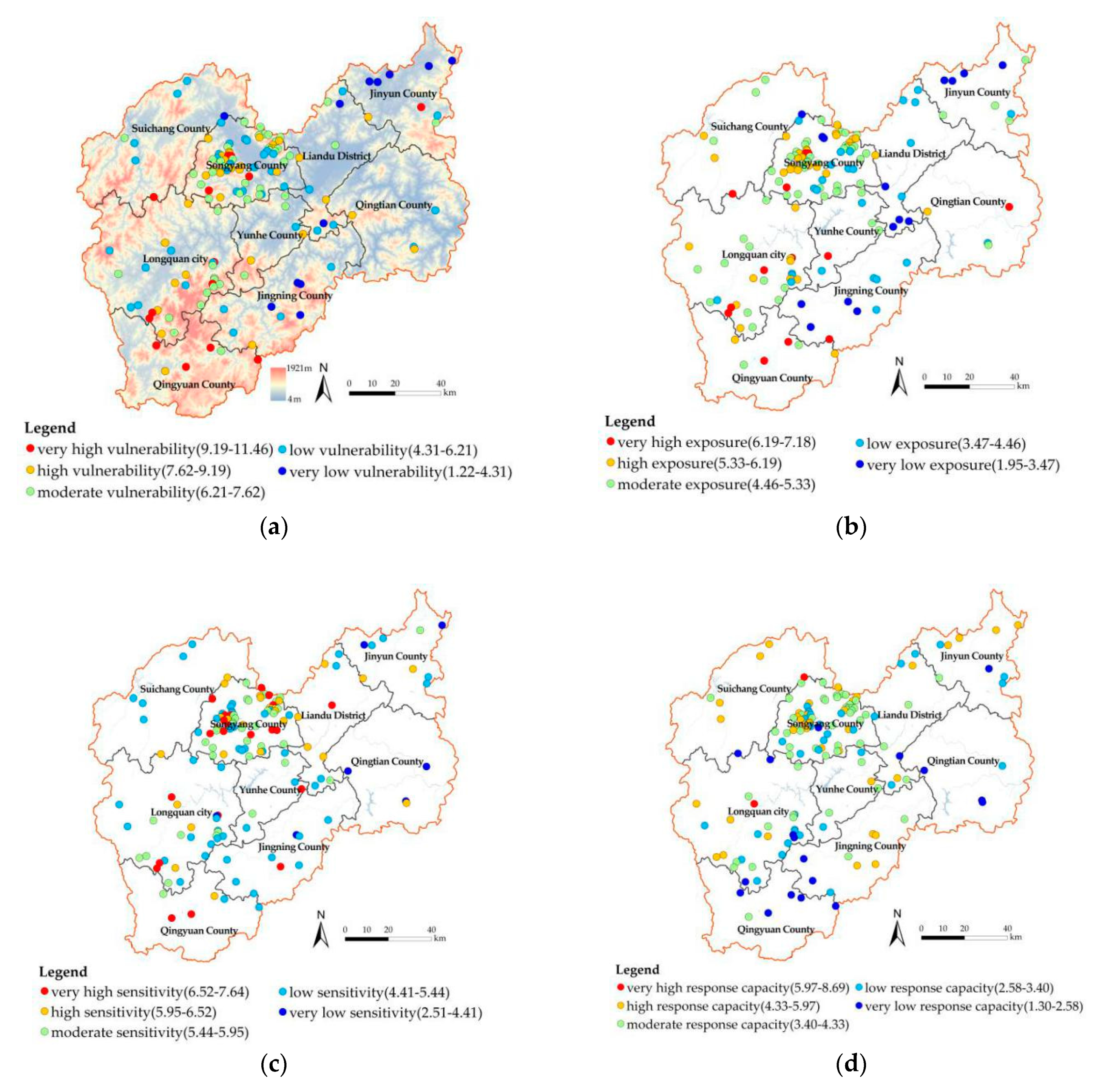
4.1. Spatial Distribution
4.1.1. Exposure
4.1.2. Sensitivity
4.1.3. Adaptive Capacity
4.1.4. Vulnerability
4.2. Vulnerability Validation
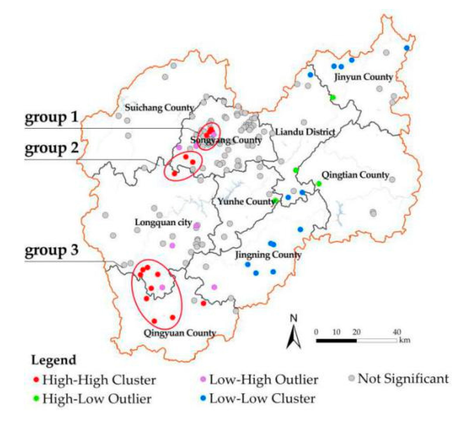
4.3. Spatial Autocorrelation
4.4. Impact Factor of Adaptive Capacity
4.4.1. Selection of Variables
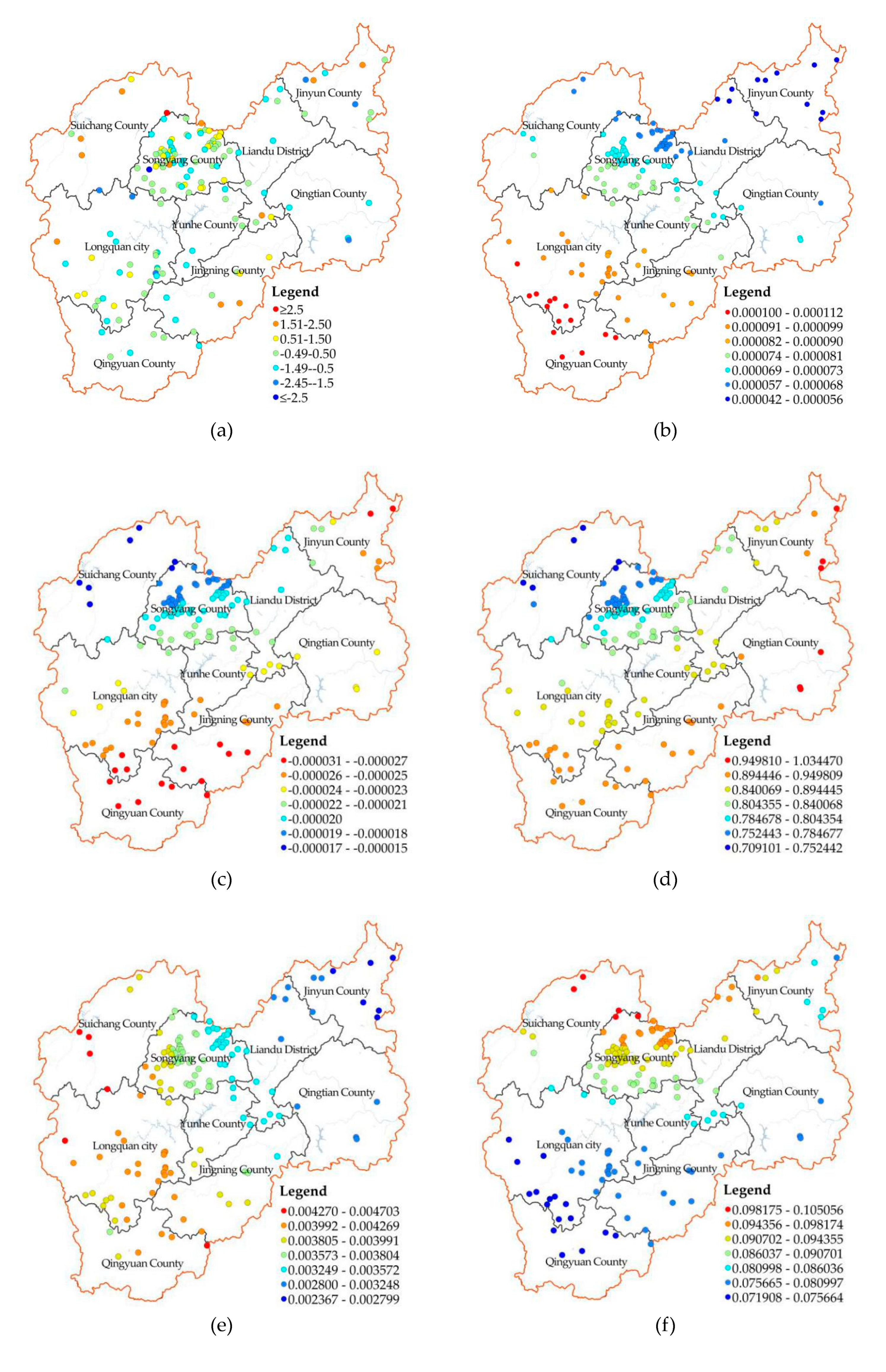
4.4.2. Analysis of Impact Factors
4.4.3. Spatial Variation of the Impact Factor
5. Discussion
5.1. Influencing Factors of Adaptive Capacity
5.2. Suggestions on the Classification Strategies of High Vulnerability Clusters
5.3. Contributions and Implications
5.4. Limitations and Suggestions for Future Work
6. Conclusions
Author Contributions
Funding
Conflicts of Interest
References
- Li, B.; Luo, Q.; Liu, P.; Zhang, J.Q. Knowledge Maps Analysis of Traditional Villages Research in China Based on the Citespace Method. Econ. Geogr. 2017, 37, 207–214. [Google Scholar]
- Dewi, L.K.Y. Modeling the Relationships between Tourism Sustainable Factor in the Traditional Village of Pancasari. Procedia Soc. Behav. Sci. 2014, 135, 57–63. [Google Scholar] [CrossRef] [Green Version]
- Sesotyaningtyas, M.; Manaf, A. Analysis of Sustainable Tourism Village Development at Kutoharjo Village, Kendal Regency of Central Java. Procedia Soc. Behav. Sci. 2015, 184, 273–280. [Google Scholar] [CrossRef] [Green Version]
- Debnath, R.; Bardhan, R. Resource Symbiosis Model through bricolage: A livelihood generation assessment of an Indian village. J. Rural Stud. 2018, 60, 105–121. [Google Scholar] [CrossRef]
- Akinciturk, N.; Kilic, M. A study on the fire protection of historic Cumalıkızık village. Int. J. Sustain. High. Educ. 2004, 5, 213–219. [Google Scholar] [CrossRef]
- González-Arqueros, M.L.; Mendoza, M.E.; Bocco, G.; Castillo, B.S. Flood susceptibility in rural settlements in remote zones: The case of a mountainous basin in the Sierra-Costa region of Michoacán, Mexico. J. Environ. Manag. 2018, 223, 685–693. [Google Scholar] [CrossRef]
- Yingchun, C.; Yukun, Z. Appraisal and Selection of “Chinese Traditional Village” and Study on the Village Distribution. Archit. J. 2013, 12, 44–49. [Google Scholar]
- Pan, A. Study on mobility-disadvantage group’risk perception and coping behaviors of abrupt geological hazards in coastal rural area of China. Environ. Res. 2016, 148, 574–581. [Google Scholar] [CrossRef]
- Jiang, X. 130 hours do not give up hope—Zhejiang Lishui Lidong village landslide disaster rescue record. China Fire 2015, 22, 22–26. [Google Scholar]
- Schneiderbauer, S.; Ehrlich, D. Risk, Hazard and People’s Vulnerability to Natural Hazards: A Review of Definitions, Concept and Data; European Commission-Joint Research Centre (EC-JRE): Brussels, Belgium, 2004. [Google Scholar]
- Houghton, J.; Meira Filho, L.; Callander, B.; Harris, N.; Kattenberg, A.; Maskell, K. IPCC Climate Change. The IPCC Second Assessment Report; Cambridge University Press: New York, NY, USA, 1996. [Google Scholar]
- McCarthy, J.J.; Canziani, O.F.; Leary, N.A.; Dokken, D.J.; White, K.S. (Eds.) Climate Change 2001: Impacts, Adaptation and Vulnerability; Cambridge University Press: Cambridge, UK, 2001. [Google Scholar]
- Eakin, H.; Luers, A.L. Assessing the vulnerability of social-environmental systems. Soc. Sci. Electron. Publ. 2006, 5, 365–394. [Google Scholar] [CrossRef] [Green Version]
- Handayani, W.; Rudiarto, I.; Setyono, J.S.; Chigbu, U.E.; Sukmawati, A.M.A. Vulnerability assessment: A comparison of three different city sizes in the coastal area of Central Java, Indonesia. Adv. Clim. Change Res. 2017, 8, 286–296. [Google Scholar] [CrossRef]
- Jha, R.K.; Gundimeda, H. An integrated assessment of vulnerability to floods using composite index—A district level analysis for Bihar, India. Int. J. Disaster Risk Reduct. 2019, 35, 101074. [Google Scholar] [CrossRef]
- Chen, S.; Zha, X.; Bai, Y.; Wang, L. Evaluation of soil erosion vulnerability on the basis of exposure, sensitivity, and adaptive capacity: A case study in the Zhuxi watershed, Changting, Fujian Province, Southern China. Catena 2019, 177, 57–69. [Google Scholar] [CrossRef]
- Mejía-Navarro, M.; Wohl, E.E.; Oaks, S.D. Geological hazards, vulnerability, and risk assessment using GIS: Model for Glenwood Springs, Colorado. Geomorphology 1994, 10, 331–354. [Google Scholar] [CrossRef]
- Fedeski, M.; Gwilliam, J. Urban sustainability in the presence of flood and geological hazards: The development of a GIS-based vulnerability and risk assessment methodology. Landsc. Urban Plan. 2007, 83, 50–61. [Google Scholar] [CrossRef]
- Jiang, W.; Deng, Y.; Tang, Z.; Cao, R.; Chen, Z.; Jia, K. Adaptive capacity of mountainous rural communities under restructuring to geological disasters: The case of Yunnan Province. J. Rural Stud. 2016, 47, 622–629. [Google Scholar] [CrossRef]
- Kaynia, A.M.; Papathoma-Köhle, M.; Neuhäuser, B.; Ratzinger, K.; Wenzel, H.; Medina-Cetina, Z. Probabilistic assessment of vulnerability to landslide: Application to the village of Lichtenstein, Baden-Württemberg, Germany. Eng. Geol. 2008, 101, 33–48. [Google Scholar] [CrossRef]
- Valensise, G.; Tarabusi, G.; Guidoboni, E.; Ferrari, G. The forgotten vulnerability: A geology- and history-based approach for ranking the seismic risk of earthquake-prone communities of the Italian Apennines. Int. J. Disaster Risk Reduct. 2017, 25, 289–300. [Google Scholar] [CrossRef]
- Ambrosi, C.; Strozzi, T.; Scapozza, C.; Wegmüller, U. Landslide hazard assessment in the Himalayas (Nepal and Bhutan) based on Earth-Observation data. Eng. Geol. 2018, 237, 217–228. [Google Scholar] [CrossRef]
- Infante, D.; Confuorto, P.; Di Martire, D.; Ramondini, M.; Calcaterra, D. Use of DInSAR Data for Multi-level Vulnerability Assessment of Urban Settings Affected by Slow-moving and Intermittent Landslides. Procedia Eng. 2016, 158, 470–475. [Google Scholar] [CrossRef] [Green Version]
- Zou, J.; Zhu, Q.; Liu, P. The Vulnerability Factors of Tourism Traditional Villages Based on the Interpretation Structural Model. Econ. Geogr. 2018, 38, 219–225. [Google Scholar]
- Yang, Q.; Liu, Q.; Yin, S.; Zhang, J.; Yang, X.; Gao, Y. Vulnerability and influencing factors of rural transportation environment in Qinling-Daba mountainous areas: A case study of Luonan county in Shaanxi province. Acta Geogr. Sin. 2019, 74, 1236–1251. [Google Scholar]
- Zou, J.; Liu, Y.; Tan, F.; Liu, P. Landscape Vulnerability and Quantitative Evaluation of Traditional Villages: A Case Study of Xintian County, Hunan Province. Sci. Geogr. Sin. 2018, 38, 1292–1300. [Google Scholar]
- Zhang, S. Theory and practice of historic environment preservation in Japan. J. Tsinghua Univ. Sci. Technol. 2000, 1, 44–48. [Google Scholar]
- Fatiguso, F.; De Fino, M.; Cantatore, E.; Caponio, V. Resilience of historic built environments: Inherent qualities and potential strategies. Procedia Eng. 2017, 180, 1024–1033. [Google Scholar] [CrossRef]
- Sesana, E.; Gagnon, A.S.; Bonazza, A.; Hughes, J.J. An integrated approach for assessing the vulnerability of World Heritage Sites to climate change impacts. J. Cult. Herit. 2020, 41, 211–224. [Google Scholar] [CrossRef]
- Pavlova, I.; Makarigakis, A.; Depret, T.; Jomelli, V. Global overview of the geological hazard exposure and disaster risk awareness at world heritage sites. J. Cult. Herit. 2017, 28, 151–157. [Google Scholar] [CrossRef]
- Yuan, C.; He, Y.; Feng, Y.; Wang, P. Fire hazards in heritage villages: A case study on Dangjia Village in China. Int. J. Disaster Risk Reduct. 2018, 28, 748–757. [Google Scholar] [CrossRef]
- Ortega, J.; Vasconcelos, G.; Rodrigues, H.; Correia, M.; Ferreira, T.M.; Vicente, R. Use of post-earthquake damage data to calibrate, validate and compare two seismic vulnerability assessment methods for vernacular architecture. Int. J. Disaster Risk Reduct. 2019, 39, 101242. [Google Scholar] [CrossRef]
- Mosoarca, M.; Onescu, I.; Onescu, E.; Azap, B.; Chieffo, N.; Szitar-Sirbu, M. Seismic vulnerability assessment for the historical areas of the Timisoara city, Romania. Eng. Fail. Anal. 2019, 101, 86–112. [Google Scholar] [CrossRef]
- Pataki, B.; Zsuffa, I.; Hunyady, A. Vulnerability assessment for supporting the revitalisation of river floodplains. Environ. Sci. Policy 2013, 34, 69–78. [Google Scholar] [CrossRef]
- Mattei, G.; Rizzo, A.; Anfuso, G.; Aucelli, P.P.C.; Gracia, F.J. A tool for evaluating the archaeological heritage vulnerability to coastal processes: The case study of Naples Gulf (southern Italy). Ocean Coast. Manag. 2019, 179, 104876. [Google Scholar] [CrossRef]
- Du, F.; Okazaki, K. Building improvement responses to multi-hazard risk in the historic Dali Dong Village, Guizhou, China. Int. J. Disaster Risk Reduct. 2016, 19, 64–74. [Google Scholar] [CrossRef]
- Shukla, R.; Sachdeva, K.; Joshi, P.K. Inherent vulnerability of agricultural communities in Himalaya: A village-level hotspot analysis in the Uttarakhand state of India. Appl. Geogr. 2016, 74, 182–198. [Google Scholar] [CrossRef]
- Lishui Municipal Statistics Bureau. Lishui Statistical Yearbook; China Statistics Press: Beijing, China, 2018. [Google Scholar]
- Xu, H.; Zhu, Y.; Zhou, H. On the practice and thinking of the comprehensive treatment of geological disasters in Lishui City, Lishui City’s “Life Project” of geological disaster prevention and control with “big move and quick treatment”. Zhejiang Land Resour. 2018, 12, 20–23. [Google Scholar]
- Gaode Open Platform. Available online: http://lbs.amap.com/ (accessed on 2 January 2020).
- Geographical Information Monitoring Cloud Platform. Available online: www.dsac.cn (accessed on 2 January 2020).
- Resource and Enviroment Data Cloud Platform. Available online: http://www.resdc.cn (accessed on 2 January 2020).
- Hu, Y.; Chen, S.; Cao, W.; CAO, C. The Concept and Cultural Connotation of Traditional Villages. Urban Dev. Stud. 2014, 1, 10–13. [Google Scholar]
- Ministry of Housing and Urban-rural Development of the People’s Republic of China. Available online: http://www.mohurd.gov.cn/wjfb/201404/t20140429_217798.html (accessed on 2 January 2020).
- Liu, L.; Yin, K.L. Analysis of rainfall infiltration mechanism of rainstorm landslide. Rock Soil Mech. Wuhan 2008, 29, 1061. [Google Scholar]
- Jinliang, H.; Shuren, W.; Huabin, W. Preliminary study on geological hazard chains. Earth Sci. Front. 2007, 14, 11–20. [Google Scholar]
- Peng, L.; Xu, D.; Wang, X. Vulnerability of rural household livelihood to climate variability and adaptive strategies in landslide-threatened western mountainous regions of the Three Gorges Reservoir Area, China. Clim. Dev. 2019, 11, 469–484. [Google Scholar] [CrossRef]
- Jurjonas, M.; Seekamp, E. Rural coastal community resilience: Assessing a framework in eastern North Carolina. Ocean Coast. Manag. 2018, 162, 137–150. [Google Scholar] [CrossRef]
- Adger, W.N. Vulnerability. Glob. Environ. Chang. 2006, 16, 268–281. [Google Scholar] [CrossRef]
- Anselin, L.; Kelejian, H.H. Testing for spatial error autocorrelation in the presence of endogenous regressors. Int. Reg. Sci. Rev. 1997, 20, 153–182. [Google Scholar] [CrossRef] [Green Version]
- Anselin, L. The local indicators of spatial association: LISA. Geogr. Anal. 1995, 27, 93–115. [Google Scholar] [CrossRef]
- Kenney, J.F.; Keeping, E.S. Linear Regression and Correlation. In Mathematics of Statistics, 3rd ed.; Van Nostrand: Princeton, NJ, USA, 1962; pp. 252–285. [Google Scholar]
- Demek, J. Manual of Detailed Geomorphological Mapping; Cambridge University Press: London, UK, 1972; p. 344. [Google Scholar]
- Brunsdon, C.; Fotheringham, S.; Charlton, M. Geographically weighted regression- modelling spatial non- stationarity. J. R. Stat. Soc. 1998, 47, 431–443. [Google Scholar] [CrossRef]
- Jenks, G.F. The Data Model Concept in Statistical Mapping. In International Yearbook of Cartography; Frenzel, K., Ed.; George Philip & Son: London, UK, 1967; Volume 7, pp. 186–190. [Google Scholar]
- Cheng, W.; Zhou, C.; Chai, H.; Zhao, S.; Liu, H.; Zhou, Z. Research and compilation of the Geomorphologic Atlas of the People’s Republic of China (1:1,000,000). J. Geogr. Sci. 2011, 21, 89–100. [Google Scholar] [CrossRef]
- Kang, J.Y.; Zhang, J.H.; Hu, H.; Zhou, J.; Xiong, J. Analysis on the spatial distribution characteristics of Chinese traditional villages. Prog. Geogr. 2016, 35, 839–850. [Google Scholar]


| Criteria | Factors | Indexes | Descriptions | Methods | Data |
|---|---|---|---|---|---|
| Exposure (E) | Intensity of geological hazard risk events | E1 Topographic relief | Number of altitude changes between the highest point and the lowest point within a unit | The bayesian change-point analysis showed that the best statistical unit for Lishui region is 0.176 km2 | (1) |
| E2 Level of geological hazard risk | Grade of geological disaster susceptibility | Score 1-4, according to the grade of no, low, medium, and high susceptibility. | (2) | ||
| E3 Level of rainstorm risk | Grade of rainstorm disaster susceptibility | Score 1-4, according to the rainfall contour gradient | (3) | ||
| Scale of hazard-affected bodies | E4 Proportion of the traditional building area | Area percentage of traditional buildings (cultural relics, historic buildings, and traditional residences) among the village’s overall buildings | Direct use | (4) | |
| E5 Number of historic landscape elements | Number of landscape relics such as ancient roads, bridges, culverts, walls, wells, ponds, and trees | Direct use | (4) | ||
| Sensitivity (S) | Sensitivity of traditional buildings | S1 Sensitivity of traditional building materials | Possibility of the damage of traditional buildings materials after geological hazards | Score 1-5, according to stone, black brick, clay brick, rammed earth, and wood, multiplied by the percentage of each material and then summed | (4) |
| S2 Sensitivity of traditional buildings’ structure | The possibility of buildings structures’ damage to geological hazards | Score 1-5, according to masonry, brick, wood, wood, civil, soil, multiplied by the percentage of each type of structure and then summed | (4) | ||
| S3 Age of traditional buildings | Average year of construction of the traditional buildings in the village | Score 1-5, according to the period of the Republic of China and later, Qing, Ming, Yuan, and Song Dynasty, multiplied by the percentage of each year of built type and summed | (4) | ||
| Sensitivity of historic landscape elements | S4 Sensitivity of materials of historic landscape elements | Possibility of historic landscape damage in geological hazards | Score 1-5, according to stone, black brick, clay brick, rammed earth, and wood, multiplied by the percentage of each material and then summed | (4) | |
| S5 Age of historic landscape elements | Average year of construction of the historic landscape elements in the village | Score 1-5, according to the period of the Republic of China and later, Qing, Ming, Yuan, and Song Dynasty, multiplied by the percentage of each year of built type and summed | (4) | ||
| Adaptive capacity (AC) | Human capital | A1 Occupancy rate of traditional buildings | Percentage of inhabited traditional buildings among the village’s buildings | Direct use | (4) |
| Economic wealth | A2 Annual per-capita income of the villager | Average annual income per resident in one traditional village | Direct use | (4) | |
| A3 Annual village’s collective income | Annual collective economy of the village, such as income from commune-run enterprises and institutions, accumulation fund, etc. | Direct use | (4) |
| Slope | Altitude (M) | Total Number | ||||||||
|---|---|---|---|---|---|---|---|---|---|---|
| Level To Slightly Sloping Terrain (0°–2°) | Slightly Sloping Terrain (2°–5°) | Strongly Sloping Terrain (5°–15°) | Curt Steep (15°–25°) | Extremely Steep (25°–35°) | Plain-Hill (<200) | Low Mountain (200–500) | Middle Mountain (500–1000) | High Mountain (>1000) | ||
| Very high HEVTV | 0.0% | 14.3% | 42.9% | 28.6% | 14.3% | 0.00% | 28.6% | 64.3% | 7.1% | 14 |
| Very high exposure | 0.0% | 7.7% | 38.5% | 38.5% | 15.4% | 0.00% | 30.8% | 69.2% | 0.00% | 13 |
| Very high sensitivity | 4.6% | 18.2% | 45.5% | 27.3% | 4.6% | 13.6% | 27.3% | 54.6% | 4.6% | 22 |
| Very low adapive capacity | 0.0% | 11.1% | 66.7% | 16.7% | 5.6% | 0.00% | 44.4% | 44.4% | 11.1% | 18 |
| Vulnerability Grade | Interval Value | Number | Percentage (%) |
|---|---|---|---|
| Very high | 9.19–11.76 | 14 | 9.5 |
| High | 7.62–9.19 | 33 | 22.3 |
| Moderate | 6.21–7.62 | 48 | 32.4 |
| Low | 4.31–6.21 | 41 | 27.7 |
| Very low | 1.22–4.31 | 12 | 8.1 |
| Total | 1.22–11.21 | 148 | 100 |
| Elements | Indicators | Quantification Methods |
|---|---|---|
| A Geographical | A1 Terrain elevation | Use DEM data corresponding to each traditional village’s coordinate data. |
| A2 Distance from the township | The coordinate data of township points are sorted out from the POI data of Lishui, and we use ArcGIS to calculate the straight distance between the township and the village. | |
| A3 Distance from the highway entrance | The coordinate data of high-speed toll stations are sorted out from the POI data of Lishui, and we used ArcGIS to calculate the straight distance between the high-speed toll station and the village. | |
| B Demographics | B1 Population of permanent residents | Directly extracted from Chinese traditional village survey registration form of Lishui. |
| B2 Percentage of the resident population | It refers to the ratio of resident population to household registration population, which could be directly extracted from the Chinese traditional village survey registration form of Lishui. | |
| C Social | C1 Number of facilities | Using ArcGIS’s location selection tool, we selected the POI within 2km of each traditional village point, and then spatial summed them to obtain the number of facilities. |
| C2 Number of Weibo check-ins | To a certain extent, this data could represent network attentions and visitor numbers. Importing Lishui’s Weibo check-in data into ArcGIS, we created a 2km buffer based on each traditional village point, and then spatially summed them to obtain the number of Weibo check-ins of each village. | |
| C3 Number of honors | It refers to the number of honors at or above the provincial or national level, which could be directly extracted from Chinese traditional village survey registration form of Lishui. |
| Variable | Coefficient | Standard Error | t_Statistic | Robust_Pr | VIF | OLS Diagnostics | |
|---|---|---|---|---|---|---|---|
| Intercept | 2.67567 | 0.345 | 7.751 | 0.000000 *** | - | Number of observations | 148 |
| A1 Terrain elevation | −0.00011 | 0.000 | −0.336 | 0.748 | 1.394 | R2 | 0.335 |
| A2 Distance from the township | 0.00007 | 0.000 | 2.727 | 0.007257 *** | 1.115 | AdjR2 | 0.297 |
| A3 Distance from the highway entrance | −0.00002 | 0.000 | −2.558 | 0.017020 ** | 1.199 | F-Prob | 0.000 * |
| B1 Population of permanent residents | −0.00009 | 0.000 | −0.581 | 0.721 | 2.288 | Wald-Prob | 0.000 * |
| B2 Percent of resident population | 1.00429 | 0.233 | 4.310 | 0.002236 *** | 2.430 | K(BP)-Prob | 0.007 * |
| C1 Number of facilities | 0.00395 | 0.003 | 1.265 | 0.055 * | 1.305 | AIC | 381.914 |
| C2 Number of Weibo check-in | −0.00013 | 0.000 | −0.492 | 0.602 | 1.665 | AICc | 383.520 |
| C3 Number of honors | 0.09538 | 0.037 | 2.589 | 0.057 * | 1.188 | Sigma 2 | 0.719 |
| Variable | Minimum | Upper Quartile | Median | Lower Quartile | Maximum | Mean |
|---|---|---|---|---|---|---|
| Distance from the township | 4.2E−05 | 6.7E−05 | 7.2E−05 | 8.8E−05 | 1.1E−04 | 7.6E−05 |
| Distance from the highway entrance | −3.1E−05 | −2.5E−05 | −2.2E−05 | −2.0E−05 | −1.5E−05 | −2.2E−05 |
| Percentage of resident population | 7.1E−01 | 7.9E−01 | 8.2E−01 | 8.8E−01 | 1.0E+00 | 8.4E−01 |
| Number of facilities | 2.4E−03 | 3.5E−03 | 3.7E−03 | 4.0E−03 | 4.7E−03 | 3.7E−03 |
| Number of honors | 7.2E−02 | 7.9E−02 | 9.0E−02 | 9.4E−02 | 1.0E−01 | 8.7E−02 |
© 2020 by the authors. Licensee MDPI, Basel, Switzerland. This article is an open access article distributed under the terms and conditions of the Creative Commons Attribution (CC BY) license (http://creativecommons.org/licenses/by/4.0/).
Share and Cite
Liu, S.; Ge, J.; Li, W.; Bai, M. Historic Environmental Vulnerability Evaluation of Traditional Villages Under Geological Hazards and Influencing Factors of Adaptive Capacity: A District-Level Analysis of Lishui, China. Sustainability 2020, 12, 2223. https://doi.org/10.3390/su12062223
Liu S, Ge J, Li W, Bai M. Historic Environmental Vulnerability Evaluation of Traditional Villages Under Geological Hazards and Influencing Factors of Adaptive Capacity: A District-Level Analysis of Lishui, China. Sustainability. 2020; 12(6):2223. https://doi.org/10.3390/su12062223
Chicago/Turabian StyleLiu, Sheng, Jian Ge, Wangming Li, and Ming Bai. 2020. "Historic Environmental Vulnerability Evaluation of Traditional Villages Under Geological Hazards and Influencing Factors of Adaptive Capacity: A District-Level Analysis of Lishui, China" Sustainability 12, no. 6: 2223. https://doi.org/10.3390/su12062223