What Are the Key Factors Affecting Air Pollution? Research on Jiangsu, China from the Perspective of Spatial Differentiation


Abstract
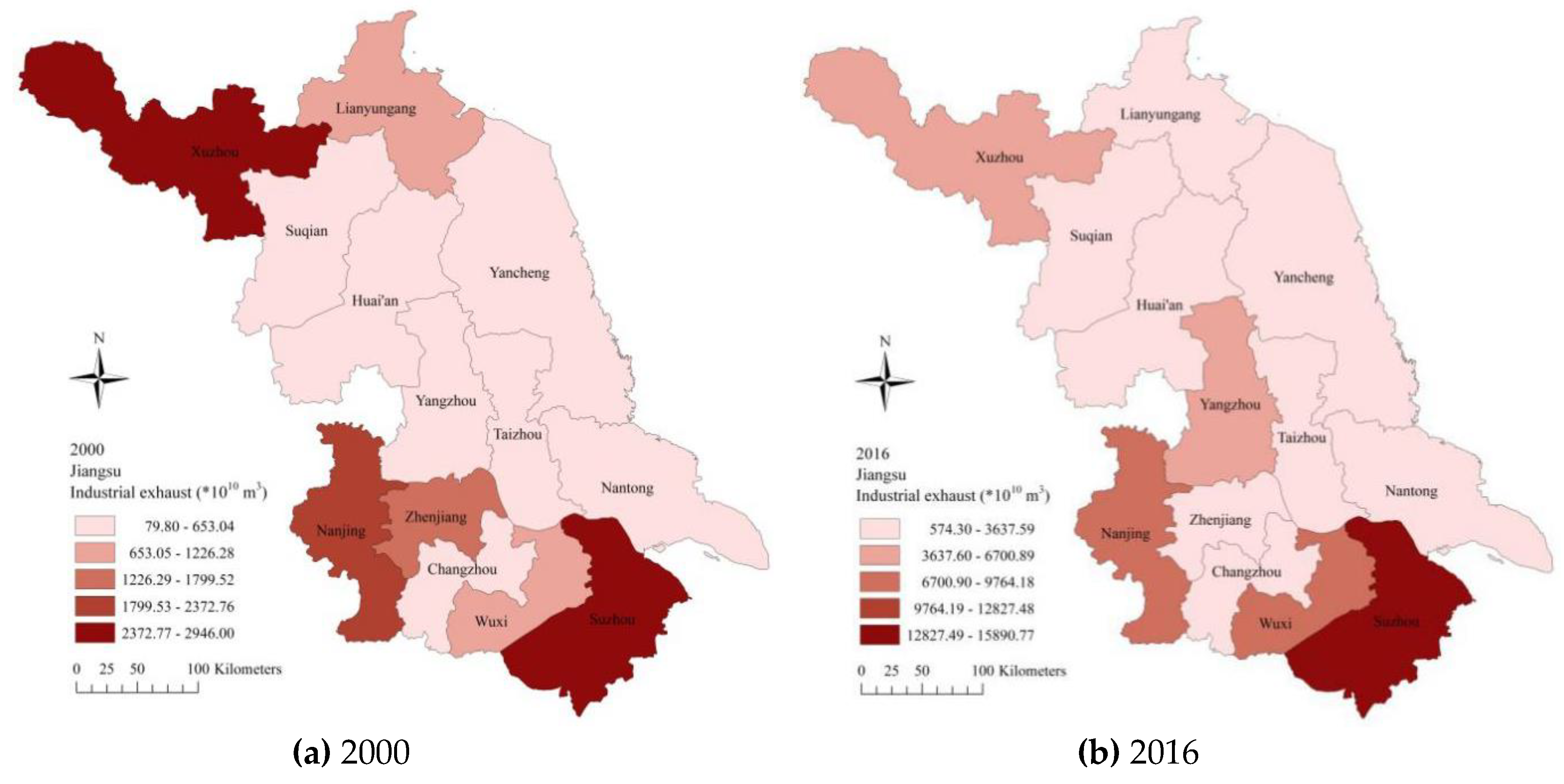
:1. Introduction
2. Research Design
2.1. Research Method
2.1.1. Space Weight Setting
2.1.2. Spatial Correlation Test
- (1)
- First quadrant (high–high): indicates that a high-level area is surrounded by other high-level areas.
- (2)
- Second quadrant (low–high): indicates that a high-level area surrounds a low-level area.
- (3)
- Third quadrant (low–low): indicates that the area and its surroundings are both low-level areas.
- (4)
- Fourth quadrant (high–low): indicates that one area is high, and the surrounding areas are low.
2.2. Space Panel Model
2.2.1. Spatial Lag Model
2.2.2. Spatial Autoregression Model
2.2.3. Spatial Dubin Model
2.3. Variable Selection
3. Results and Discussion
3.1. Spatial Correlation Analysis
3.2. Empirical Results
3.2.1. Analysis of Spatial Measurement Results
3.2.2. Analysis of Sub-Regional SDM Results
3.3. Robustness Test
4. Conclusions
Author Contributions
Funding
Conflicts of Interest
References
- Hou, J.; Zhang, S.; Song, H.; Li, F. Spatial–temporal heterogeneous evolution of haze pollution in China as deduced with the use of spatial econometrics. Sustainability 2019, 11, 7058. [Google Scholar] [CrossRef] [Green Version]
- National Bureau of Statistics. China Statistical Yearbook; China Statistics Press: Beijing, China, 2019; Available online: http://navi.cnki.net/KNavi/YearbookDetail?pcode=CYFD&pykm=YINFN&bh= (accessed on 1 September 2019).
- Li, W.B.; Long, R.Y.; Chen, H.; Chen, F.Y.; Zheng, X.; Yang, M.Y. Effect of Policy Incentives on the Uptake of Electric Vehicles in China. Sustainability 2019, 11, 3323. [Google Scholar] [CrossRef] [Green Version]
- Jiangsu Provincial Bureau of Statistics. Jiangsu Statistical Yearbook; China Statistics Press: Beijing, China, 2018; Available online: http://navi.cnki.net/KNavi/YearbookDetail?pcode=CYFD&pykm=YJSTJ&bh= (accessed on 1 August 2018).
- Grossman, G.; Krueger, A. Environmental Impacts of a North American Free Trade Agreement; National Bureau of Economic Research: New York, NY, USA, 1991; Volume 8, pp. 223–250. Available online: https://www.nber.org/papers/w3914 (accessed on 1 March 1994).
- Lin, B.Q.; Liu, X.Y. Carbon emissions in China’s urbanization stage: Influencing factors and emission reduction strategies. Econ. Res. J. 2010, 45, 66–78. [Google Scholar]
- Song, M.L.; Wang, S.H. China’s “inflection point” of environmental Kuznets curve: Empirical analysis based on provincial data. Manag. World 2011, 10, 168–169. [Google Scholar]
- Wang, M.; Huang, Y. China’s environmental pollution and economic growth. Q. J. Econ. 2015, 2, 557–578. [Google Scholar]
- Xiang, K.; Song, D.Y. Spatial empirical study on PM2.5 pollution in China’s provinces. China Popul. Resour. Environ. 2015, 9, 153–159. [Google Scholar]
- Bai, L.; Jiang, L.; Zhou, H.F.; Chen, Z.S. Analysis of temporal and spatial characteristics and driving factors of air quality index in the Yangtze river economic belt—An empirical study based on Bayesian spatial econometric model. Geogr. Sci. 2018, 38, 2100–2108. Available online: http://www.cnki.com.cn/Article/CJFDTotal-DLKX201812019.htm (accessed on 15 December 2018).
- Liu, M.Z.; Yang, J.X.; Ma, D.; Ding, Z.H. Spatial differences of main air pollutants in China based on LMDI model and analysis of influencing factors. Resour. Sci. 2015, 37, 333–341. Available online: http://www.cnki.com.cn/Article/CJFDTotal-ZRZY201502014.htm (accessed on 15 February 2015).
- Selden, T.M.; Song, D. Environmental quality and development: Is there a Kuznets curve for air pollution emissions? J. Environ. Econ. Manag. 1994, 27, 147–162. [Google Scholar] [CrossRef]
- Zhang, C.; Zhu, Q.L.; Yu, T.Z. The relationship between environmental pollution and economic growth. Stat. Res. 2011, 1, 59–67. [Google Scholar] [CrossRef]
- Gao, H.X.; Yang, L.; Fu, H.D. Research and prediction of the relationship between economic growth and environmental pollution in Chinese provinces—An empirical analysis based on environmental Kuznets curve. Econ. Dyn. 2012, 1, 52–57. [Google Scholar]
- Ma, L.M.; Zhang, X. Spatial effects of smog pollution in China and economic and energy structure effects. China Ind. Econ. 2014, 4, 19–31. [Google Scholar]
- Shao, S.; Li, X.; Cao, J.H. Economic policy choice of China’s haze pollution control—Based on the perspective of spatial spillover effect. Econ. Res. J. 2016, 9, 73–88. [Google Scholar]
- Zhang, S.L.; Wang, Y.H.; Li, Y.; Zhang, P.F. Analysis of spatial distribution characteristics and influencing factors of smog in China. China Popul. Resour. Environ. 2017, 27, 15–22. Available online: http://www.cnki.com.cn/Article/CJFDTotal-ZGRZ201709003.htm (accessed on 15 September 2017).
- Leng, Y.L.; Xian, G.M.; Du, S.Z. Foreign direct investment and smog pollution—An empirical analysis based on Chinese provincial panel data. J. Int. Trade 2015, 12, 74–84. [Google Scholar]
- Liu, X.H.; Jiang, K.S. Research on the relationship between urbanization, industrial structure and haze dynamics in China—An empirical test based on provincial panel data. Ecol. Econ. 2016, 32, 19–25. [Google Scholar]
- Tang, D.C. Industrialization process, industrial structure and environmental pollution: Based on manufacturing industry and regional panel data model. Soft Sci. 2009, 23, 6–11. [Google Scholar]
- Hu, F. Research on the relationship between industrial structure upgrading, foreign trade and environmental pollution—Taking the eastern and central regions of China as an example. Inq. Econ. Issues 2011, 7, 113–118. [Google Scholar]
- Yan, Y.X.; Qi, S.Z. Time and space effects of foreign direct investment on China’s urban haze (PM2.5) pollution. China Popul. Resour. Environ. 2017, 27, 68–77. [Google Scholar]
- Jiang, L.; Zhou, H.F.; Bai, L. Spatial heterogeneity analysis of the impact of foreign direct investment on air pollution: A case study of China’s 150 urban air quality indexes (AQI). Geogr. Sci. 2018, 38, 351–360. [Google Scholar]
- Poon Jessie, P.H.; Casas, I.; He, C.F. The impact of energy, transport and trade on air pollution in China. Eurasian Geogr. Econ. 2006, 47, 118–223. Available online: https://rsa.tandfonline.com/doi/abs/10.2747/1538-7216.47.5.568 (accessed on 15 May 2013). [CrossRef]
- Gao, M.; Wu, X.P.; Guo, S.H. Urbanization process, environmental regulation and air pollution—An empirical analysis based on STIRAPT model. J. Ind. Technol. Econ. 2016, 9, 110–117. [Google Scholar]
- Li, H.J.; Zhou, D.Q.; Wei, Y.J. Factors affecting air pollution in major cities in China—A study based on analysis of pollution sources. Ecol. Econ. 2018, 34, 197–203. [Google Scholar]
- Wang, S.; Ma, Y. Influencing factors and regional discrepancies of the efficiency of carbon dioxide emissions in Jiangsu, China. Ecol. Indic. 2018, 90, 460–468. [Google Scholar] [CrossRef]
- Li, B.; Li, T. Empirical study on Kuznets curve of air pollution in China—Based on dynamic panel system GMM and threshold model test. Econ. Issues 2014, 4, 17–22. [Google Scholar]
- Wang, S. Impact of FDI on energy efficiency: An analysis of the regional discrepancies in China. Nat. Hazards 2016, 85, 1209–1222. [Google Scholar] [CrossRef]
- Li, K.; Qi, S.Z. The transmission channel analysis of FDI influencing China’s industrial energy efficiency—based on horizontal, forward and posterior correlation. J. China Univ. Geosci. 2013, 4, 27–33. [Google Scholar]
- Frankel, J.A. The Environment and Globalization; NBER Working Paper; Columbia University Press: New York, NY, USA, 2003; Available online: https://www.nber.org/papers/w10090 (accessed on 1 May 2005).
- Zhu, S.J.; Yin, S.S.; Zhong, T.L. Does the opening of high-speed rails inhibit urban environmental pollution? East China Econ. Manag. 2019, 33, 52–57. [Google Scholar]
- Liu, S.; Yang, D.; Liu, N.; Liu, X. The effects of air pollution on firms’ internal control quality: Evidence from China. Sustainability 2019, 11, 5068. [Google Scholar] [CrossRef] [Green Version]
- Wei, W.X.; Ma, X.L.; Li, P.; Chen, Y. The role of technological progress and taxation in regional air pollution control. China Popul. Resour. Environ. 2016, 26, 1–11. Available online: http://www.cnki.com.cn/Article/CJFDTotal-ZGRZ201605001.htm (accessed on 13 July 2016).


| Variable Type | Symbol | Unit | N | Avg | S | Min | Max |
|---|---|---|---|---|---|---|---|
| Explained variables | IWGE | Cubic meter | 221 | 2432.38 | 2844.92 | 79.8 | 15,890 |
| NO2 | MG/m3 | 221 | 0.038 | 0.012 | 0.015 | 0.08 | |
| Explanatory variables | P | 10,000 people | 221 | 588.774 | 188.912 | 289.3 | 1064.74 |
| PGDP | yuan | 221 | 45,201.16 | 34380 | 3993 | 145,556 | |
| T3 | % | 221 | 39.15 | 5.962 | 26.8 | 58.39 | |
| E | 10,000 kw/h | 221 | 9,224,497.6 | 1,340,216.6 | 26,872 | 7,500,000 | |
| PI | yuan | 221 | 19,403.62 | 11,226.79 | 4617 | 54,341 | |
| FDI | Billion yuan | 221 | 0.044 | 0.03 | 0.004 | 0.201 | |
| G | Virtual variable | 221 | 0.163 | 0.37 | 0 | 1 | |
| U | % | 221 | 0.532 | 0.164 | 0.137 | 0.98 |
| Year | IWGE | NO2 | ||
|---|---|---|---|---|
| Moran’s I | Z Value | Moran’s I | Z Value | |
| 2000 | −0.219 ** | −2.387 | −0.007 *** | 3.459 |
| 2001 | −0.149 ** | −2.64 | −0.037 ** | 2.267 |
| 2002 | −0.149 *** | −3.382 | −0.043 *** | 3.240 |
| 2003 | −0.063 ** | −2.116 | −0.013 *** | 3.400 |
| 2004 | −0.254 *** | −2.981 | 0.009 *** | 3.522 |
| 2005 | −0.236 *** | −2.892 | 0.041 *** | 3.702 |
| 2006 | −0.161 *** | −3.421 | 0.039 *** | 2.690 |
| 2007 | −0.185 *** | −3.164 | 0.129 *** | 3.188 |
| 2009 | −0.223 *** | −3.376 | 0.186 ** | 2.487 |
| 2010 | −0.179 ** | −2.338 | 0.202 ** | 2.791 |
| 2011 | −0.277 *** | −3.073 | 0.105 | 1.058 |
| 2012 | −0.244 *** | −3.042 | 0.215 *** | 2.757 |
| 2013 | −0.245 *** | −3.908 | 0.196 *** | 2.977 |
| 2014 | −0.101 ** | −2.399 | 0.137 ** | 2.263 |
| 2015 | −0.189 *** | −3.097 | 0.262 ** | 2.567 |
| 2016 | −0.027 *** | −3.327 | 0.309 ** | 2.264 |
| Variables | SAR | SDM | SLM | |||
|---|---|---|---|---|---|---|
| FE | RE | FE | RE | FE | RE | |
| P | 0.317 *** (0.108) | 0.278 *** (0.064) | 0.715 *** (0.142) | −1.497 *** (0.245) | 0.351 (0.262) | 0.323 ** (0.142) |
| PGDP | −0.018 (0.015) | −0.008 (0.014) | 0.094 *** (0.028) | −0.037 * (0.020) | –0.028 (0.022) | –0.018 (0.016) |
| T3 | 0.063 ** (0.024) | 0.072 *** (0.024) | −0.046 (0.032) | 0.077 * (0.042) | 0.067 * (0.036) | 0.082 ** (0.033) |
| E | 0.001 *** (0.000) | 0.001 *** (0.000) | 0.001 *** (0.000) | 0.001 *** (0.000) | 0.001 *** (0.000) | 0.001 *** (0.000) |
| PI | 0.108 *** (0.038) | 0.069 * (0.036) | 0.100 * (0.056) | −0.197 *** (0.071) | 0.085 (0.065) | 0.043 (0.043) |
| FDI | −0.489 * (0.263) | −0.392 (0.251) | −0.531 ** (0.255) | 0.480 (0.452) | −0.558 (0.385) | −0.451 (0.312) |
| G | 0.127 *** (0.023) | 0.128 *** (0.023) | 0.947 *** (0.027) | 0.612 (0.045) | 0.130 ** (0.057) | 0.131 ** (0.055) |
| U | −0.232 ** (0.092) | −0.153 * (0.092) | −0.321 *** (0.086) | 0.238 (0.167) | −0.227 (0.185) | −0.145 (0.142) |
| C | — | −0.106 (0.133) | — | −0.101 (0.217) | — | −0.092 (0.148) |
| Wald test SAR | — | — | 122.420 *** (0.000) | 122.420 *** (0.000) | — | — |
| LR test SAR | — | — | 79.710 *** (0.000) | 79.710 *** (0.000) | — | — |
| Wald test SLM | — | — | 170.260 *** (0.000) | 170.260 *** (0.000) | — | — |
| LR test SLM | — | — | 80.520 *** (0.000) | 80.520 *** (0.000) | — | — |
| Hausman(p) | — | — | 32.910 (0.000) | 32.910 (0.000) | — | — |
| Variables | SAR | SDM | SLM | |||
|---|---|---|---|---|---|---|
| FE | RE | FE | RE | FE | RE | |
| P | 0.010 (0.010) | 0.012 * (0.006) | 0.005 (0.014) | 0.009 (0.024) | 0.011 (0.018) | 0.012 (0.010) |
| PGDP | 2.52 × 10−7 * (1.36 × 10−7) | 2.91 × 10⁻⁷ ** (1.31 × 10⁻⁷) | 1.01 × 10⁻⁷ (1.98 × 10⁻⁷) | 6.32 × 10⁻⁷ ** (2.78 × 10⁻⁷) | 2.55 × 10⁻⁷ (2.62 × 10⁻⁷) | 3.01 × 10⁻⁷ (2.36 × 10⁻⁷) |
| T3 | −1.32 × 10⁻⁵ (0.000) | 8.49 × 10⁻⁷ (0.000) | −1.42 × 10⁻⁶ (0.000) | −1.12 × 10⁻⁵ (0.000) | −1.64 × 10⁻⁵ (0.000) | −5.05 × 10⁻⁶ (0.000) |
| E | 1.17 × 10⁻⁹ (1.00 × 10⁻⁹) | 1.18 × 10⁻⁹ (9.62 × 10⁻⁹) | −1.09 × 10⁻⁹ (1.62 × 10⁻⁹) | 3.76 × 10⁻⁹ (2.93 × 10⁻⁹) | 1.18 × 10⁻⁹ (1.36 × 10⁻⁹) | 1.22 × 10⁻⁹ (1.52 × 10⁻⁹) |
| PI | −4.61 × 10⁻⁷ (3.50 × 10⁻⁷) | −6.60 × 10⁻⁷ ** (3.34 × 10⁻⁷) | −4.64 × 10⁻⁷ (5.51 × 10⁻⁷) | −3.83 × 10⁻⁷ (7.05 × 10⁻⁷) | −4.64 × 10⁻⁷ (5.82 × 10⁻⁷) | −6.70 × 10⁻⁷ (5.35 × 10⁻⁷) |
| FDI | −0.052 ** (0.025) | −0.050 ** (0.024) | −0.049 * (0.025) | −0.052 (0.045) | −0.052 (0.041) | −0.050 (0.037) |
| G | −0.007 *** (0.002) | −0.007 *** (0.002) | −0.010 *** (0.003) | 0.004 (0.004) | −0.008 * (0.004) | −0.001 * (0.017) |
| U | −0.004 (0.009) | −0.004 (0.009) | −0.005 (0.008) | −0.033 ** (0.004) | −0.004 (0.018) | −0.050 (0.037) |
| C | — | −0.002 * (0.001) | — | −0.001 (0.002) | — | −0.002 (0.002) |
| Wald test SAR | — | — | 122.420 *** (0.000) | 122.420 *** (0.000) | — | — |
| LR test SAR | — | — | 79.710 *** (0.000) | 79.710 *** (0.000) | — | — |
| Wald test SLM | — | — | 170.260 *** (0.000) | 170.260 *** (0.000) | — | — |
| LR test SLM | — | — | 80.520 *** (0.000) | 80.520 *** (0.000) | — | — |
| Hausman (p) | — | — | 6.850 (0.445) | 6.850 (0.445) | — | — |
| Variables | South Jiangsu | Central Jiangsu | North Jiangsu | |||
|---|---|---|---|---|---|---|
| DE | IE | DE | IE | DE | IE | |
| P | 0.402 (0.031) | 0.071 (0.378) | 0.061 (0.633) | 0.098 (0.101) | −0.455 (0.437) | −0.127 (0.652) |
| PGDP | 6.55 × 10⁻⁸ (8.05 × 10⁻⁸) | 4.86 × 10⁻⁷ (9.60 × 10⁻⁷) | −3.08 × 10⁻⁶ ** (1.26 × 10⁻⁶) | 1.43 × 10⁻⁶ (1.06 × 10⁻⁶) | −2.26 × 10⁻⁶ *** (6.38 × 10⁻⁷) | 3.00 × 10⁻⁶ *** (7.38 × 10⁻⁷) |
| T3 | 0.002 (0.010) | 0.004 (0.011) | −0.006 (0.009) | 0.005 (0.010) | −0.017 *** (0.004) | 0.026 *** (0.008) |
| E | 0.080 ** (0.040) | 0.042 (0.076) | 0.095 (0.071) | 0.147 (0.105) | −0.028 * (0.016) | 0.103 *** (0.031) |
| PI | 0.560 *** (0.131) | −0.816 *** (0.147) | 0.201 (0.256) | −0.511 * (0.279) | −0.107 ** (0.050) | −0.051 (0.074) |
| FDI | −0.103 (0.081) | −0.755 (0.944) | 0.130 (0.037) | −0.143 (0.105) | 0.260 (0.245) | 0.061 (0.469) |
| G | 0.101 (0.000) | 0.101 ** (0.051) | — | — | 0.043 (0.027) | 0.132 (0.084) |
| U | −0.012 (0.189) | 0.623 ** (0.263) | 0.231 (0.194) | −0.086 (0.223) | −0.260 ** (0.245) | 0.158 (0.217) |
| Variables | South Jiangsu | Central Jiangsu | North Jiangsu | |||
|---|---|---|---|---|---|---|
| DE | IE | DE | IE | DE | IE | |
| P | 0.006 (0.030) | 0.035 (0.036) | −0.015 (0.058) | −0.353 *** (0.094) | 0.044 (0.041) | −0.102 (0.062) |
| PGDP | 0.174 ** (0.085) | 0.150 (0.140) | −0.135 (0.137) | 0.101 (0.117) | 0.352 *** (0.064) | 0.223 *** (0.079) |
| T3 | −0.001 (0.001) | −3.23 × 10⁻⁶ (0.001) | −0.002 *** (0.001) | 0.001 (0.010) | −0.001 *** (0.000) | 0.001 (0.001) |
| E | 0.002 (0.004) | 0.002 (0.007) | 0.024 *** (0.007) | −0.019 * (0.010) | 0.004 *** (0.001) | −0.004 (0.003) |
| PI | −1.38 × 10⁻⁶ (1.13 × 10⁻⁶) | 8.70 × 10⁻⁷ (1.29 × 10⁻⁶) | −1.23 × 10⁻⁶ *** (2.42 × 10⁻⁶) | 1.43 × 10⁻⁶ *** (2.77 × 10⁻⁶) | 1.29 × 10⁻⁶ *** (4.63 × 10⁻⁷) | 3.47 × 10⁻⁷ (7.02 × 10⁻⁷) |
| FDI | −0.066 (0.067) | −0.008 (0.089) | −0.057 * (0.033) | −0.313 *** (0.100) | −0.101 *** (0.023) | −0.105 ** (0.046) |
| G | 0.003 (0.000) | 0.003 (0.004) | — | — | 0.001 (0.003) | 0.005 (0.008) |
| U | −0.033 * (0.018) | 0.023 (0.026) | 0.023 (0.020) | 0.070 *** (0.021) | 0.025 ** (0.010) | 0.022 (0.020) |
| Var | PM2.5 | IWGE | |||||||
|---|---|---|---|---|---|---|---|---|---|
| (1) | (2) | (3) | (4) | (5) | (6) | (7) | (8) | (9) | |
| P | 0.305 ** (0.001) | 0.353 *** (0.083) | 0.309 *** (0.084) | 0.306 *** (0.100) | 0.274 ** (0.110) | 0.121 ** (0.122) | 0.098 * (0.114) | 0.159 * (0.091) | 0.148 ** (0.096) |
| PGDP | 3.61 × 10⁻⁶ ** (4.72 × 10⁻⁶) | — | 0.008 ** (0.001) | 0.003 * (0.003) | 0.003 * (0.003) | 0.012 *** (0.004) | 0.005 ** (0.004) | 0.004 * (0.004) | 0.006 ** (0.004) |
| T3 | 0.020 (0.009) | — | — | −0.004 ** (0.003) | −0.002 * (0.003) | −0.002 * (0.003) | −0.001 * (0.003) | −0.002 * (0.003) | −0.001 * (0.003) |
| E | 4.98 × 10⁻⁸ ** (8.40 × 10⁻⁸) | — | — | — | 0.033 * (0.001) | 0.031 ** (0.002) | 0.014 ** (0.001) | 0.013 ** (0.001) | 0.003 * (0.001) |
| PI | 1.59 × 10⁻⁶ (0.000) | — | — | — | — | 0.013 *** (0.005) | 0.005 ** (0.001) | 0.003 * (0.005) | 0.004 * (0.004) |
| FDI | −0.720 ** (0.859) | — | — | — | — | — | −0.050 *** (0.001) | −0.043 ** (0.001) | −0.039 *** (0.001) |
| G | 0.015 ** (0.082) | — | — | — | — | — | — | 0.013 * (0.002) | 0.011 * (0.004) |
| U | −0.190 * (0.300) | — | — | — | — | — | — | — | −0.006 * (0.003) |
| C | — | −0.803 ** (0.226) | −0.858 ** (0.228) | −0.911 (0.258) | 0.021 (0.019) | −0.309 (0.316) | −0.251 (0.294) | −0.434 * (0.230) | −0.378 (0.244) |
© 2020 by the authors. Licensee MDPI, Basel, Switzerland. This article is an open access article distributed under the terms and conditions of the Creative Commons Attribution (CC BY) license (http://creativecommons.org/licenses/by/4.0/).
Share and Cite
Wang, S.; Hua, G.; Zhou, H. What Are the Key Factors Affecting Air Pollution? Research on Jiangsu, China from the Perspective of Spatial Differentiation. Sustainability 2020, 12, 2371. https://doi.org/10.3390/su12062371
Wang S, Hua G, Zhou H. What Are the Key Factors Affecting Air Pollution? Research on Jiangsu, China from the Perspective of Spatial Differentiation. Sustainability. 2020; 12(6):2371. https://doi.org/10.3390/su12062371
Chicago/Turabian StyleWang, Shijin, Guihong Hua, and Huiying Zhou. 2020. "What Are the Key Factors Affecting Air Pollution? Research on Jiangsu, China from the Perspective of Spatial Differentiation" Sustainability 12, no. 6: 2371. https://doi.org/10.3390/su12062371