GIS Based Assessment and Design for Areas Vulnerable to Soil Disasters: Case Study of Namhyeun-dong, South Korea


Abstract
:1. Introduction
2. Materials and Methods
2.1. Study Area and Data
2.2. Rational Formula for Rainfall Runoff
2.3. Evidence-Based Soil Data Analysis Methods
2.4. Catchment Analysis Method
3. Results
3.1. Results of the Catchment Analysis
- First assumption: The soil is carried along with the heavy rain.
- Second assumption: The soil moves from high to low elevation.
- Third assumption: The soil in one catchment moves in the same direction as the slope.
- Fourth assumption: The damage caused by the soil is greater in heavily populated residential areas than in unoccupied mountainous areas.
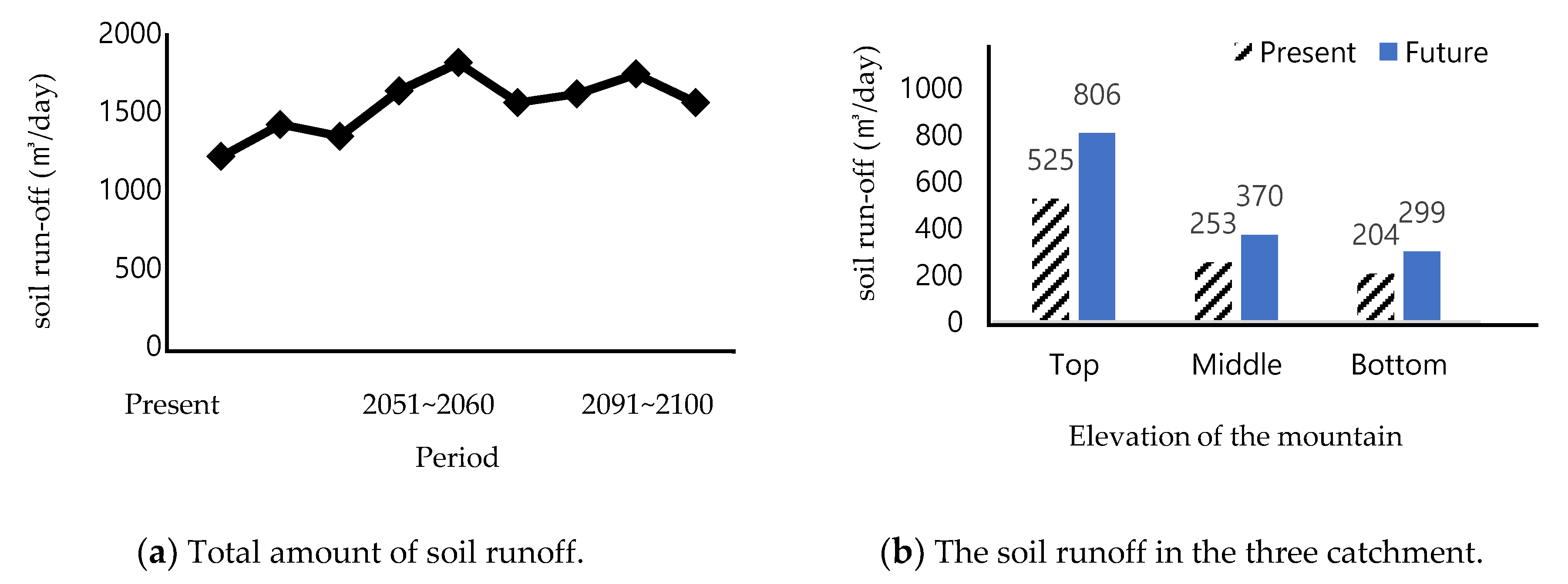
3.2. Results for Soil Runoff
3.3. Design Purpose
3.4. Design Suggestion
3.4.1. Designs for the Upper Catchments of the Mountain
3.4.2. Designs for the Middle Catchments of the Mountain
3.4.3. Designs for the Bottom Catchments of the Mountain
3.4.4. Proposed Layout for Catchment A
3.4.5. Proposed Layout for Catchment B
3.4.6. Proposed Layout for Catchment C
3.5. RCP 8.5 Scenario
4. Conclusions
Author Contributions
Funding
Acknowledgments
Conflicts of Interest
Appendix A

| Date | Precipitation | Total Amount of Rainfall | Actual Amount of Rainfall Outflow | Actual Amount of Soil Runoff | Coefficient of the Soil Runoff | C Value |
|---|---|---|---|---|---|---|
| 16.4.13 | 28.1 | 1826.5 | 547.95 | 1.03 | 0.0019 | 0.30 |
| 16.4.21 | 37.2 | 2418 | 773.76 | 1.55 | 0.0020 | 0.32 |
| 16.5.10 | 25.7 | 1670.5 | 501.15 | 0.94 | 0.0019 | 0.30 |
| 16.6.24 | 43.3 | 2814.5 | 985.075 | 2.16 | 0.0022 | 0.35 |
| 16.7.4 | 179.1 | 11,641.5 | 7916.22 | 24.56 | 0.0031 | 0.68 |
| 16.7.7 | 38.8 | 2522 | 807.04 | 1.61 | 0.0020 | 0.32 |
| 16.9.8 | 22.8 | 1482 | 444.6 | 0.83 | 0.0019 | 0.30 |
| 16.9.17 | 97.8 | 6357 | 3432.78 | 12.42 | 0.0036 | 0.54 |
| 16.9.27 | 39.7 | 2580.5 | 825.76 | 1.65 | 0.0020 | 0.32 |
| 16.10.8 | 32.3 | 2099.5 | 671.84 | 1.34 | 0.0020 | 0.32 |
| Total for 2016 | 544.8 | 35,412 | 16,906.18 | 48.09 | - | - |
| 17.4.6 | 15.9 | 1033.5 | 258.375 | 0.81 | 0.0031 | 0.25 |
| 17.4.17 | 26.8 | 1742 | 487.76 | 1.71 | 0.0035 | 0.28 |
| 17.7.2 | 39.5 | 2567.5 | 821.6 | 3.29 | 0.0040 | 0.32 |
| 17.7.3 | 69.9 | 4543.5 | 2317.185 | 9.21 | 0.0040 | 0.51 |
| 17.7.4 | 34.0 | 2210 | 707.2 | 2.83 | 0.0040 | 0.32 |
| 17.7.15 | 24.5 | 1592.5 | 445.9 | 1.56 | 0.0035 | 0.28 |
| 17.7.25 | 27.6 | 1794 | 502.32 | 1.76 | 0.0035 | 0.28 |
| 17.7.31 | 29.2 | 1898 | 607.36 | 2.43 | 0.0040 | 0.32 |
| 17.8.9 | 37.3 | 2424.5 | 727.35 | 2.73 | 0.0038 | 0.30 |
| 17.8.15 | 34.4 | 2236 | 693.16 | 2.69 | 0.0039 | 0.31 |
| 17.8.21 | 36.1 | 2346.5 | 750.88 | 3.00 | 0.0040 | 0.32 |
| 17.8.24 | 49.8 | 3237 | 1424.28 | 7.2 | 0.0051 | 0.44 |
| 17.9.11 | 77.0 | 5005 | 2702.7 | 9.82 | 0.0036 | 0.54 |
| Total for 2017 | 502.0 | 32,630 | 12,446.07 | 49.05 | - | - |
| 18.4.14 | 36.7 | 2385.5 | 763.36 | 3.05 | 0.0040 | 0.32 |
| 18.4.23 | 38.9 | 2528.5 | 809.12 | 3.24 | 0.0040 | 0.32 |
| 18.5.6 | 20.5 | 1332.5 | 333.125 | 1.04 | 0.0031 | 0.25 |
| 18.5.12 | 23.4 | 1521 | 380.25 | 1.19 | 0.0031 | 0.25 |
| 18.6.26 | 30.3 | 1969.5 | 590.85 | 2.22 | 0.0038 | 0.30 |
| 18.6.27 | 50.4 | 3276 | 1474.2 | 7.27 | 0.0049 | 0.45 |
| 18.6.30 | 22.4 | 1456 | 364 | 1.14 | 0.0031 | 0.25 |
| 18.7.1 | 119.9 | 7793.5 | 5299.58 | 15.73 | 0.0030 | 0.68 |
| 18.7.2 | 43.9 | 2853.5 | 970.19 | 4.12 | 0.0042 | 0.34 |
| 18.7.9 | 35.5 | 2307.5 | 738.4 | 2.95 | 0.0040 | 0.32 |
| 18.8.26 | 78.2 | 5083 | 2744.82 | 10.25 | 0.0037 | 0.54 |
| 18.8.28 | 140.0 | 9100 | 6279 | 18.25 | 0.0029 | 0.69 |
| 18.8.30 | 73.3 | 4764.5 | 2572.83 | 9.85 | 0.0038 | 0.54 |
| 18.8.31 | 42.6 | 2769 | 996.84 | 4.49 | 0.0045 | 0.36 |
| 18.9.3 | 89.9 | 5843.5 | 3330.795 | 11.25 | 0.0034 | 0.57 |
| 18.9.21 | 32.9 | 2138.5 | 684.32 | 2.74 | 0.0040 | 0.32 |
| Total for 2018 | 878.8 | 57,122 | 28,331.68 | 98.76 | - | - |
References
- Korea Meteorological Administration. Meteorological Technology & Policy; Korea Meteorological Administration: Seoul, Korea, 2015; Volume 8, pp. 2092–5336. [Google Scholar]
- IPCC. Intergovernmental Panel on Climate Change; IPCC: Geneva, Switzerland, 2014. [Google Scholar]
- Hayat, H.; Akbar, T.; Tahir, A.; Hassa, Q.; Dewan, A.; Irshad, M. Simulating current and future river-flows in the Karakoram and Himalayan regions of Pakistan using Snowmelt-Runoff model and RCP scenarios. Water 2019, 11, 761. [Google Scholar] [CrossRef] [Green Version]
- Rahman, M.; Hingsheng, C.; Islam, M.; Dewan, A.; Iqbal, J.; Washakh, R.; Shufeng, T. Flood susceptibility assessment in Banglandesh using machine learning and multi-criteria decision analysis. Earth Syst. Environ. 2019, 3, 585–601. [Google Scholar] [CrossRef]
- Lee, C.; Chung, J. A study on development of the housing guidelines for climate change response—Focused on extreme heat and heat island effect. J. Archit. Inst. Korea Plan. Des. 2017, 33, 77–89. [Google Scholar] [CrossRef]
- Woo, C.; Kwon, H.; Lee, C.; Kim, K. Landslide hazard prediction map based on logistic regression model for applying in the whole country of South Korea. J. Korean Soc. Hazard Mitig. 2014, 14, 117–123. [Google Scholar] [CrossRef] [Green Version]
- Jebari, S.; Berndtsson, R.; Olsson, J.; Bahri, A. Soil erosion estimation based on rainfall disaggregation. J. Hydrol. 2012, 436–437, 102–110. [Google Scholar] [CrossRef]
- Tang, Q.; Xu, Y.; Bennett, S.J.; Li, Y. Assessment of soil erosion using RUSLE and GIS: A case study of the Yangou watershed in the Loess Plateau, China. Environ. Earth Sci. 2015, 73, 1715–1724. [Google Scholar] [CrossRef] [Green Version]
- Markose, V.; Jayappa, J. Soil loss estimation and prioritization of sub-watersheds of Kali River basin, Karnataka, India, using RUSLE and GIS. Environ. Monit. Assess. 2016, 188, 1–16. [Google Scholar] [CrossRef] [PubMed]
- Renard, K.G.; Foster, G.R.; Weesies, G.A.; McCool, D.K.; Yorder, D.C. Predicting Soil Erosion by Water: A Guide to Conservation Planning with the Revised Universal Soil Loss Equation (RUSLE); Agriculture Handbook; U.S. Department of Agriculture: Washington, DC, USA, 2007; Volume 703.
- Gayen, A.; Saha, S.; Pourghasemi, H. Soil erosion assessment using RUSLE model and its validation by FR probability model. Geocarto Int. 2019. [Google Scholar] [CrossRef]
- Kim, M. Evaluation of soil loss in the Sapkyo river basin. J. Korean Geotech. Soc. 2002, 3, 19–27. [Google Scholar]
- Hwang, S.H.; Ham, D.H. A study on the monthly trend of Seoul hourly rainfall using BLRPM. J. Korean Soc. Hazard Mitig. 2014, 14, 267–278. [Google Scholar] [CrossRef] [Green Version]
- Cha, D.; Lee, D.; Jin, C.; Kim, G.; Choi, Y.; Suh, M.; Ahn, J.; Hong, S.; Min, S.; Park, S.; et al. Future changes in summer precipitation in regional climate simulations over the Korean Peninsula forced by multi-RCP scenarios of HadGEM2-AO. Pac. J. Atmos. Sci. 2016, 52, 139–149. [Google Scholar] [CrossRef]
- Yiannakou, A.; Salata, K. Adaptation to climate change through spatial planning in compact urban areas: A case study in the city of Thessaloniki. Sustainability 2017, 9, 271. [Google Scholar] [CrossRef] [Green Version]
- Huan, W.; Lee, Y. Strategic planning for land use under extreme climate changes: A case study in Taiwan. Sustainability 2017, 8, 53. [Google Scholar] [CrossRef] [Green Version]
- Woldemariam, G.; Iguala, A.; Tekalign, S.; Reddy, R. Spatial modeling of soil erosion risk and its implication for conservation planning: The case of the gobele wastershed, East Haraghe Zone, Ethiopia. Land 2018, 7, 25. [Google Scholar] [CrossRef] [Green Version]
- Djoukbala, O.; Mazour, M.; Hasbaia, M.; Benselama, O. Estimating of water erosion in semiarid regions using RUSLE equation under GIS environment. Environ. Earth Sci. 2018, 77, 1–13. [Google Scholar] [CrossRef]
- Zerihun, M.; Mohammedyasin, M.; Sewnet, D.; Adem, A.; Lakew, M. Assessment of soil erosion using RUSLE, GIS and remote sensing in NW Ethiopia. Geoderma Reg. 2018, 12, 83–90. [Google Scholar] [CrossRef]
- Lisboa, E.; Blanco, C.; Maia, R.; Bello, L. A stochastic estimation of sediment production in an urban catchment using the USLE model. Hydrol. Sci. J. 2017, 62, 2571–2586. [Google Scholar] [CrossRef]
- Mulvaney, T.J. On the use of self-registering rain and flood gauges in making observations on the relationship of rainfall and runoff and of flood discharges in a given catchment. Trans. Inst. Civ. Eng. (Irel.) 1850, 10, 18–31. [Google Scholar]
- Prasannakumar, V.; Shiny, R.; Geetha, N.; Vijith, H. Spatial prediction of soil erosion risk by remote sensing, GIS and RUSLE approach: A case study of Siruvani river watershed in Attapady valley, Kerala, India. Environ. Earth Sci. 2011, 64, 965–972. [Google Scholar] [CrossRef]
- Somprasong, K.; Chaiwiwatworakul, P. Estimation of potential cadmium contamination using an integrated RUSLE, GIS and remote sensing technique in a remote watershed area: A case study of the Mae Tao Basin, Thailand. Environ. Earth Sci. 2015, 73, 4805–4818. [Google Scholar] [CrossRef]
- Teng, H.; Liang, Z.; Chen, S.; Liu, Y.; Rossel, R.A.V.; Chappell, A.; Yu, W.; Shi, Z. Current and future assessments of soil erosion by water on the Tibetan Plateau based on RUSLE and CMIP5 climate models. Sci. Total Environ. 2018, 635, 673–686. [Google Scholar] [CrossRef] [PubMed]
- Kuichling, E. The relation between the rainfall and the discharge of sewers in populous districts. Trans. ASCE 1889, 20, 1–60. [Google Scholar]
- Lee, H. General rainfall patterns in Indonesia and the potential impacts of local season rainfall intensity. Water 2015, 7, 1751–1768. [Google Scholar] [CrossRef]
- Stancanelli, L.; Peres, D.; Cancelliere, A.; Foti, E. A combined triggering-propagation modeling approach for the assessment of rainfall induced debris flow susceptibility. J. Hydrol. 2017, 550, 130–143. [Google Scholar] [CrossRef] [Green Version]
- Saha, S.; Gayen, A.; Pourghasemi, H.; Tiefenbacher, J. Identification of soil erosion-susceptible areas using fuzzy logic and analytical hierarchy process modeling in an agricultural watershed of Burdwan district, India. Environ. Earth Sci. 2019, 78, 1–18. [Google Scholar] [CrossRef]
- Yaseen, Z.; Awadh, S.; Sharafati, A.; Shahid, S. Complementary data-intelligence model for river flow simulation. J. Hydrol. 2018, 567, 180–190. [Google Scholar] [CrossRef]
- Chen, T.; Niu, R.; Li, P.; Zhang, L.; Du, B. Regional soil erosion risk mapping using RUSLE, GIS, and remote sensing: A case study in Miyun Watershed, North China. Environ. Earth Sci. 2011, 63, 533–541. [Google Scholar] [CrossRef]
- ESRI. ArcGIS Desktop 10.5; Environmental Systems Research Institute: Redlands, CA, USA, 2016. [Google Scholar]
- Demirci, A.; Karaburun, A. Estimation of soil erosion using RUSLE in a GIS framework: A case study in the Buyukcekmece Lake watershed, northwest Turkey. Environ. Earth Sci. 2012, 66, 903–913. [Google Scholar] [CrossRef]
- Farhan, Y.; Nawaiseh, S. Spatial assessment of soil erosion risk using RUSLE and GIS techniques. Environ. Earth Sci. 2015, 74, 4649–4669. [Google Scholar] [CrossRef]
- Choi, B. Analysis of the adequacy check dam according to soil loss using rusle. J. Korean Soc. Surv. Geod. Photogramm. Cartogr. 2016, 34, 515–524. [Google Scholar] [CrossRef]
- O’Callaghan, J.; Mark, D. The extraction of drainage networks from digital elevation data. Comput. Vis. Graph. Image Process. 1984, 28, 323–344. [Google Scholar] [CrossRef]
- Fairfield, J.; Leymarie, P. Drainage networks from grid digital elevation models. Water Resour. Res. 1991, 27, 709–717. [Google Scholar] [CrossRef]
- Survila, K.; Yildirim, A.; Li, T.; Liu, Y.; Tarboton, D.; Wang, S. A scalable high-performance topographic flow direction algorithm for hydrological information analysis. In Proceedings of the XSEDE16 Conference on Diversity, Big Data, and Science at Scale, Miami, FL, USA, 17–21 July 2016; Volume 11. [Google Scholar] [CrossRef] [Green Version]
- Tarboton, D. A new method for the determination of flow directions and upslope areas in grid digital elevation models. Water Resour. Res. 1997, 33, 309–319. [Google Scholar] [CrossRef] [Green Version]
- Available online: https://www.weather.go.kr/weather/warning/standard.jsp (accessed on 15 May 2019).


| Category | Division | Section | Coefficient |
|---|---|---|---|
| Cultivation | Rice paddy | Organized fields | 0.7 |
| Unorganized fields | 0.8 | ||
| Crop farm | Common, specialty crops | 0.45~0.60 | |
| Orchards, etc. | 0.5 | ||
| Forest | Grassland | Natural grassland | 0.25 |
| Artificial grassland | 0.05~0.10 | ||
| Forest | Coniferous forest | 0.5 | |
| Deciduous forest | 0.5 | ||
| Mixed forest | 0.5 | ||
| Recreational | Golf courses | 0.50~0.75 | |
| Amusement parks | 0.10~0.25 | ||
| Cemeteries | 0.10~0.25 | ||
| Rock faces and mountains | 0.7 | ||
| City | Residential and commercial areas | Residential zones | 0.60~0.70 |
| High rise zones | 0.50~0.70 | ||
| Commercial and office zones | 0.70~0.95 | ||
| Vacant land | 0.35 | ||
| Transportation facilities | Roads | 0.70~0.95 | |
| Railroad and buffer areas | 0.7 | ||
| Airports | 0.95 | ||
| Ports | 0.8 | ||
| Industrial areas | Industrial zones | 0.60~0.90 | |
| Industrial/vacant zones | 0.50~0.80 | ||
| Public areas | Educational and military zones | 0.50~0.70 | |
| Public land | 0.50~0.70 |
| Catchment | Size | Current | ‘21~’30 | ‘31~’40 | ‘41~’50 | ‘51~’60 |
|---|---|---|---|---|---|---|
| 1 | 13.1 | 49.5 | 56.8 | 53.4 | 65.5 | 72.5 |
| 2 | 5.6 | 19.3 | 22.1 | 20.8 | 25.5 | 28.3 |
| 3 | 12.6 | 44.9 | 51.4 | 48.4 | 59.3 | 65.7 |
| 4 | 14.3 | 51.2 | 58.7 | 55.2 | 67.7 | 75.0 |
| 5 | 19.3 | 63.1 | 72.3 | 68.0 | 83.5 | 92.4 |
| 6 | 10.8 | 33.7 | 38.6 | 36.3 | 44.5 | 49.3 |
| 7 | 8.6 | 28.2 | 32.3 | 30.4 | 37.3 | 41.3 |
| 8 | 8.2 | 47.8 | 54.7 | 51.5 | 63.2 | 69.9 |
| 9 | 21.8 | 68.0 | 77.9 | 73.3 | 90.0 | 99.6 |
| 10 | 9.4 | 51.6 | 59.1 | 55.6 | 68.2 | 75.5 |
| 11 | 9.9 | 43.1 | 49.4 | 46.5 | 57.0 | 63.1 |
| 12 | 12.5 | 39.7 | 45.4 | 42.7 | 52.5 | 58.0 |
| 13 | 11.5 | 35.8 | 41.0 | 38.6 | 47.3 | 52.4 |
| 14 | 25.1 | 109.4 | 125.4 | 117.9 | 144.7 | 160.2 |
| 15 | 9.7 | 30.3 | 34.7 | 32.6 | 40.0 | 44.3 |
| 16 | 23.6 | 73.2 | 83.9 | 78.9 | 96.9 | 107.2 |
| 17 | 31.1 | 96.8 | 110.9 | 104.3 | 128.0 | 141.7 |
| 18 | 24.5 | 76.3 | 87.4 | 82.2 | 100.9 | 111.7 |
| 19 | 54.1 | 13.9 | 43.4 | 49.7 | 46.7 | 57.4 |
| 20 | 9.1 | 28.2 | 32.3 | 30.4 | 37.3 | 41.3 |
| 21 | 14.9 | 116.4 | 133.3 | 125.4 | 153.9 | 170.3 |
| 22 | 17.1 | 90.2 | 103.3 | 97.2 | 119.3 | 132.0 |
| Total | 366.8 | 1210.6 | 1414.6 | 1339.5 | 1629.3 | 1808.8 |
| Catchment | Size | Current | ‘61~’70 | ‘71~’80 | ‘81~’90 | ‘91~’00 |
|---|---|---|---|---|---|---|
| 1 | 13.1 | 49.5 | 61.7 | 64.4 | 69.5 | 61.8 |
| 2 | 5.6 | 19.3 | 24.0 | 25.1 | 27.1 | 24.1 |
| 3 | 12.6 | 44.9 | 55.8 | 58.3 | 63.0 | 56.0 |
| 4 | 14.3 | 51.2 | 63.8 | 66.6 | 71.9 | 63.9 |
| 5 | 19.3 | 63.1 | 78.6 | 82.0 | 88.6 | 78.8 |
| 6 | 10.8 | 33.7 | 41.9 | 43.8 | 47.3 | 42.0 |
| 7 | 8.6 | 28.2 | 35.1 | 36.7 | 39.6 | 35.2 |
| 8 | 8.2 | 47.8 | 59.4 | 62.1 | 67.0 | 59.6 |
| 9 | 21.8 | 68.0 | 84.7 | 88.4 | 95.5 | 84.9 |
| 10 | 9.4 | 51.6 | 64.2 | 67.1 | 72.4 | 64.4 |
| 11 | 9.9 | 43.1 | 53.7 | 56.0 | 60.5 | 53.8 |
| 12 | 12.5 | 39.7 | 49.4 | 51.6 | 55.7 | 49.5 |
| 13 | 11.5 | 35.8 | 44.6 | 46.5 | 50.2 | 44.7 |
| 14 | 25.1 | 109.4 | 136.2 | 142.2 | 153.6 | 136.6 |
| 15 | 9.7 | 30.3 | 37.7 | 39.3 | 42.5 | 37.8 |
| 16 | 23.6 | 73.2 | 91.2 | 95.2 | 102.8 | 91.4 |
| 17 | 31.1 | 96.8 | 120.5 | 125.8 | 135.9 | 120.8 |
| 18 | 24.5 | 76.3 | 95.0 | 99.2 | 107.1 | 95.2 |
| 19 | 54.1 | 13.9 | 63.5 | 54 | 56.4 | 60.9 |
| 20 | 9.1 | 28.2 | 35.1 | 36.7 | 39.6 | 35.2 |
| 21 | 14.9 | 116.4 | 144.8 | 151.3 | 163.3 | 145.2 |
| 22 | 17.1 | 90.2 | 112.3 | 117.2 | 126.6 | 112.5 |
| Total | 366.8 | 1210.6 | 1553.0 | 1609.5 | 1736.0 | 1554.3 |
| Catchment Location | Type | Climate/Environment Description | Purpose of The Design |
|---|---|---|---|
| Upstream (Design Capacity: 806 ) | Type 1 | Zone where soil runoff is predicted to increase OR where an existing dam needs to be modified or redesigned. | - Adjust the effective height of the dam to increase its capacity - Increase the capacity by creating more chambers |
| Type 2 | Where a new dam needs to be installed. | Build an impermeable dam | |
| Type 3 | -Average gradient: 30–40° The valley experiences soil runoff and/or the midstream has steep slopes. | Creation a series of small dams to prevent soil debris and landslides propagating. | |
| Midstream (Design Capacity: 370 ) | Type 4 | - Average gradient: 5~10° - Slope adjacent to the mountain stream valley - Areas connected to drainage that are close to both apartments and mountainous areas | Distribute the amount and direction of water flow from the mountain valley via the installation of induction channels. |
| Downstream (Design Capacity: 299 ) | Type 5 | - Average gradient: 0~5° - Located at or near the bottom of Gwanak mountain - Areas that could suffer substantial damage due to their close proximity to apartments in residential areas that are not protected by retaining walls when landslides occur | Creating multi-use water storage via swales or unused parking areas in front of buildings. |
| Type 6 | - Average gradient: 10–20° - Entrance space in the residential area. | - Create open space. - Penetrating grasses should be planted to protect against flooding in the stream valley during peak rainfall. | |
| Type 7 | - The midpoint of the mountains where the slope is relatively gentle - Provide functional improvements of the multi-purpose facilities during dry period | - Installation of multi-purpose gabion walls that protect facilities from incoming soil debris, direct drainage and also serve as park benches, etc.) | |
| Type 8 | Natural rock slopes | Install facilities to stabilize the rock face and prevent rock falling from unstable slopes. | |
| Type 9 | Wide, flat, open land | Installation chambers to prevent the outflow of surface soil. |
© 2020 by the authors. Licensee MDPI, Basel, Switzerland. This article is an open access article distributed under the terms and conditions of the Creative Commons Attribution (CC BY) license (http://creativecommons.org/licenses/by/4.0/).
Share and Cite
Jeon, H.; Kang, J. GIS Based Assessment and Design for Areas Vulnerable to Soil Disasters: Case Study of Namhyeun-dong, South Korea. Sustainability 2020, 12, 2516. https://doi.org/10.3390/su12062516
Jeon H, Kang J. GIS Based Assessment and Design for Areas Vulnerable to Soil Disasters: Case Study of Namhyeun-dong, South Korea. Sustainability. 2020; 12(6):2516. https://doi.org/10.3390/su12062516
Chicago/Turabian StyleJeon, Hyeji, and Junsuk Kang. 2020. "GIS Based Assessment and Design for Areas Vulnerable to Soil Disasters: Case Study of Namhyeun-dong, South Korea" Sustainability 12, no. 6: 2516. https://doi.org/10.3390/su12062516