Spatiotemporal Analysis of Land Cover Changes in the Chemoga Basin, Ethiopia, Using Landsat and Google Earth Images


Abstract
:1. Introduction
2. Materials and Methods
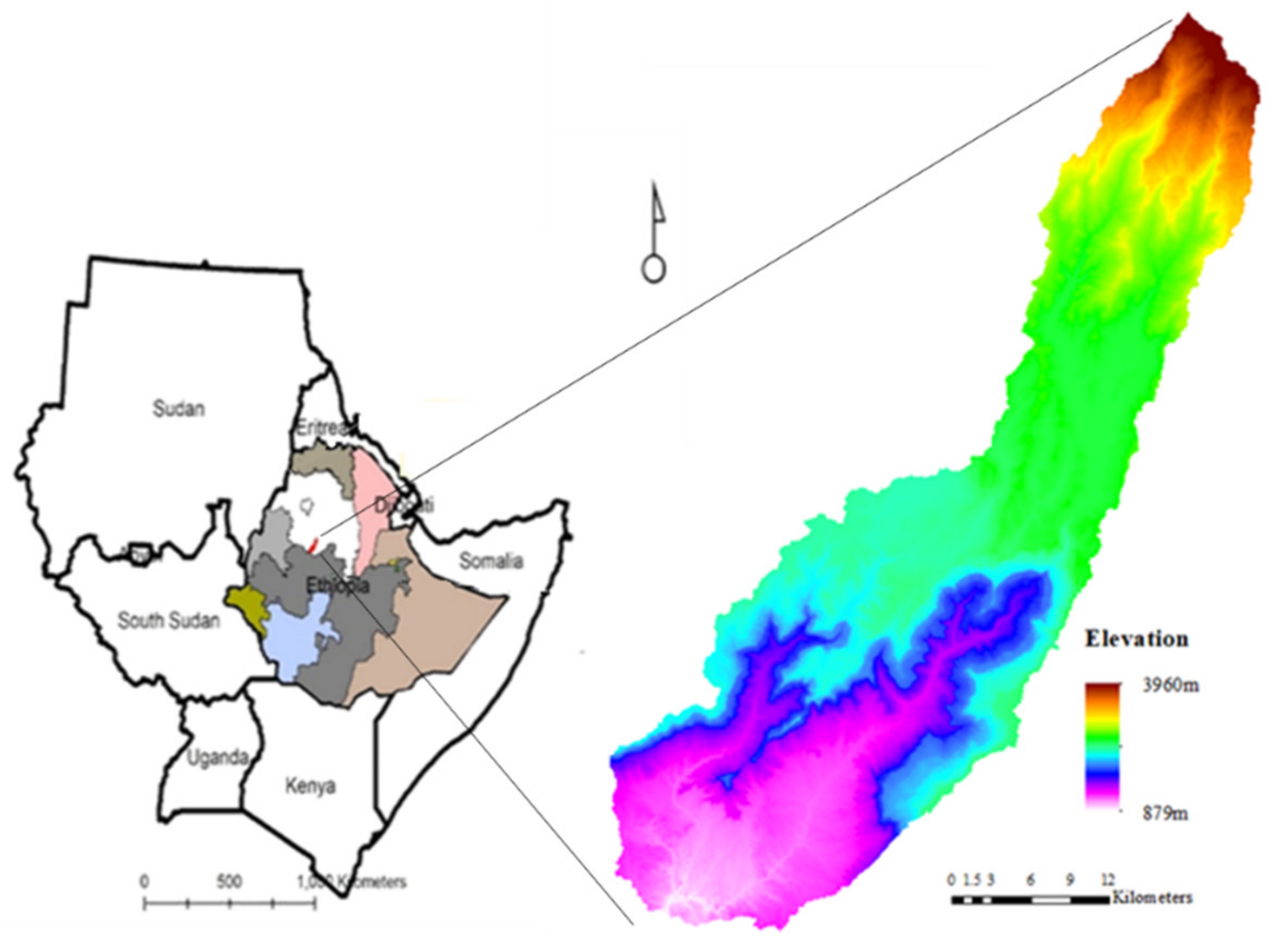
2.1. Study Area
2.2. Land Cover Classification
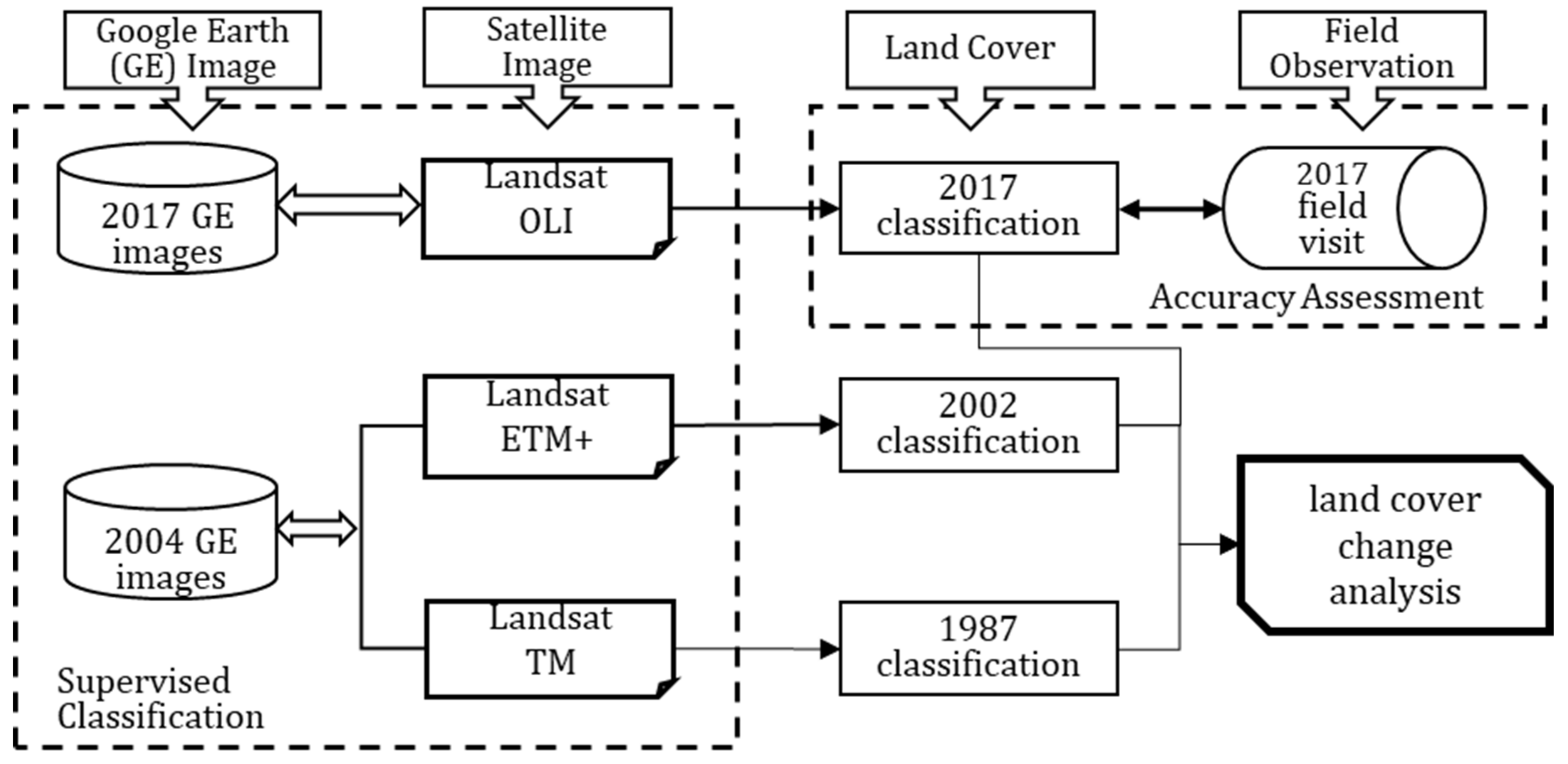
2.2.1. Data Sources and Preprocessing
2.2.2. Supervised Classification
2.3. Post-Classification
2.4. Accuracy Assessment
2.5. Land Cover Transition Analysis
3. Results
3.1. Land Classification Accuracy
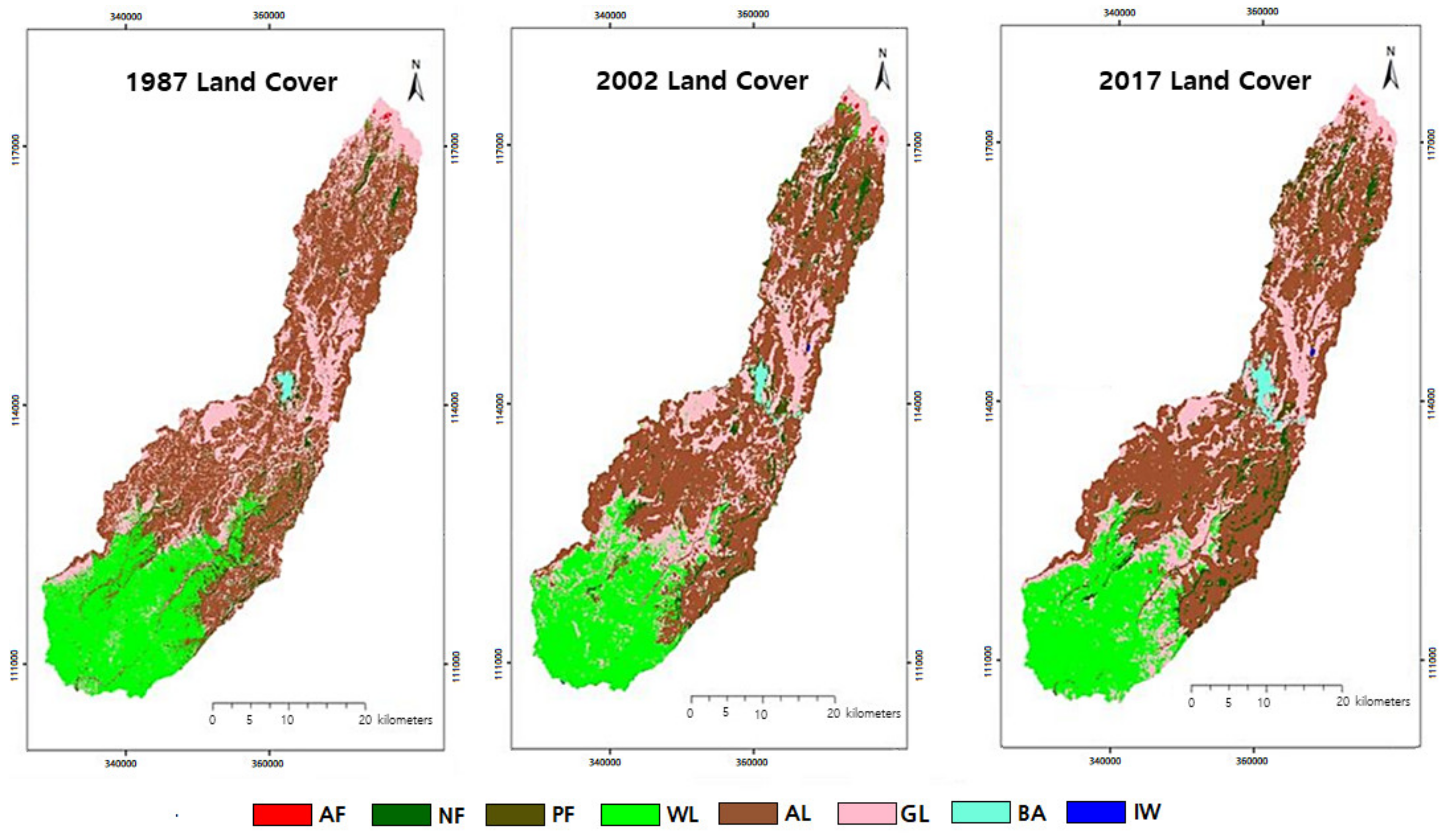
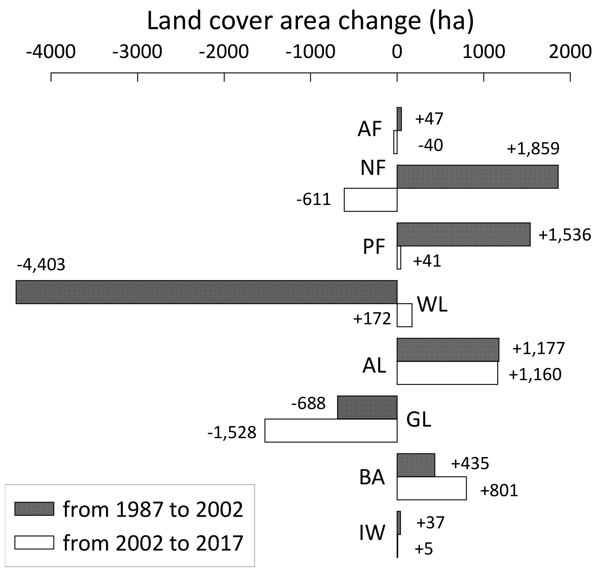
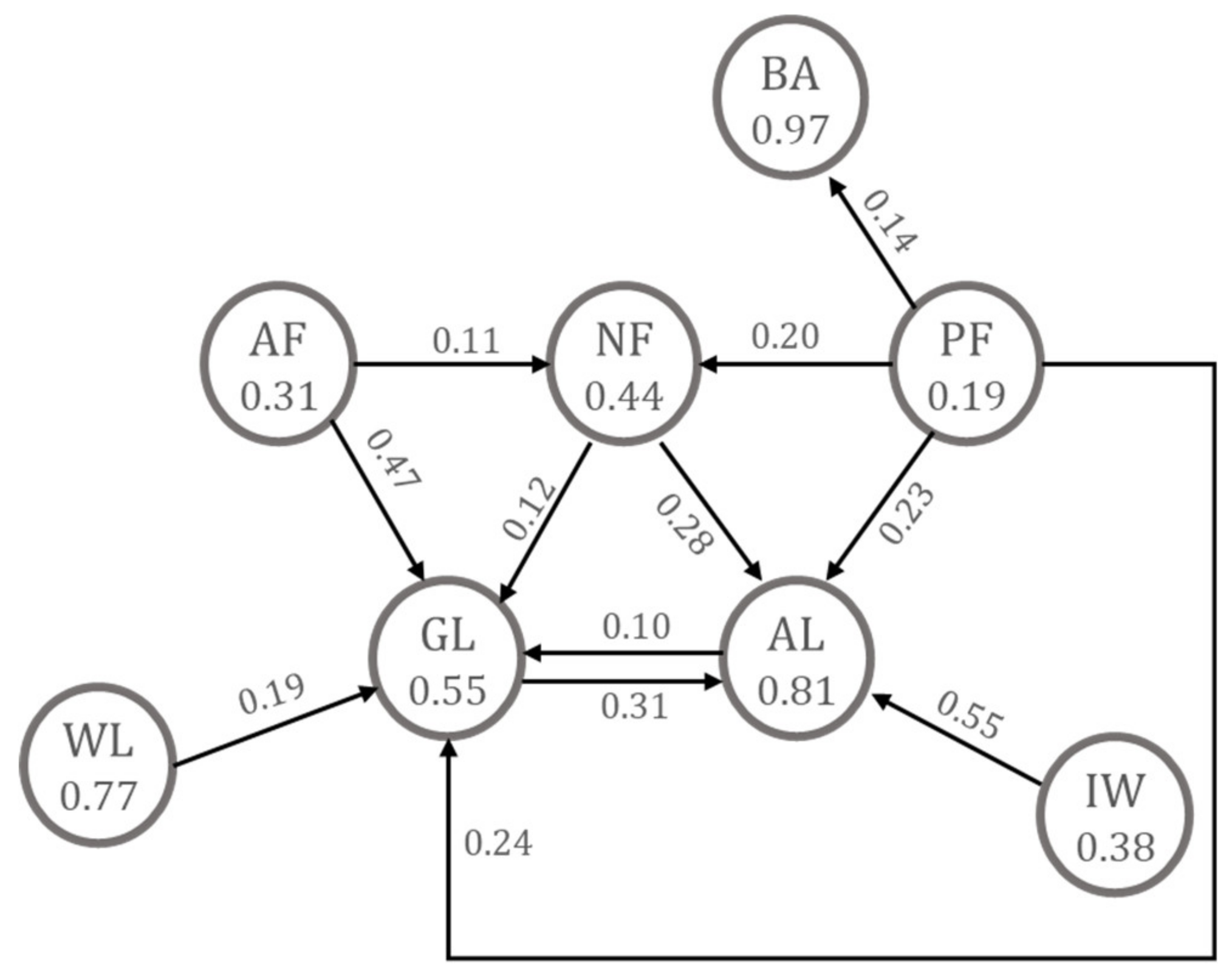
3.2. Land Cover Change Estimation
4. Discussion
5. Conclusions
Author Contributions
Funding
Conflicts of Interest
References
- Hurni, H.; Tato, K.; Zeleke, G. The implications of changes in population, land use, and land management for surface runoff in the upper Nile basin area of Ethiopia. Mt. Res. Dev. 2005, 25, 147–154. [Google Scholar] [CrossRef] [Green Version]
- Alemayehu, F.; Tolera, M.; Tesfaye, G. Land use land cover change trend and its drivers in Somodo watershed South Western, Ethiopia. Afr. J. Agric. Res. 2019, 14, 102–117. [Google Scholar]
- Ariti, A.T.; van Vliet, J.; Verburg, P.H. Land-use and land-cover changes in the central rift valley of Ethiopia: Assessment of perception and adaption of stakeholders. Appl. Geogr. 2015, 65, 28–37. [Google Scholar] [CrossRef]
- Demissie, F.; Yeshitila, K.; Kindu, M.; Schneider, T. Land use/land cover changes and their causes in Libokemkem district of south Gonder, Ethiopia. Remote Sens. Appl. Soc. Environ. 2017, 8, 224–230. [Google Scholar] [CrossRef]
- Lambin, E.F.; Geist, H.J.; Lepers, E. Dynamics of land-use and land-cover change in tropical regions. Ann. Rev. Env. Resour. 2003, 28, 205–241. [Google Scholar] [CrossRef] [Green Version]
- Lam, N.S. Methodologies for mapping land cover/land use and its change. In Advances in Land Remote Sensing: System, Modeling, Inversion and Application; Liang, S., Ed.; Springer: New York, NY, USA, 2008; pp. 341–367. [Google Scholar]
- Theobald, D.M. Development and applications of a comprehensive land use classification and map for the US. PLoS ONE 2014, 9, e94628. [Google Scholar] [CrossRef] [Green Version]
- Comber, A.; Fisher, P.; Wadsworth, R. What is land cover? Environ. Plann. B. 2005, 32, 199–209. [Google Scholar] [CrossRef] [Green Version]
- Njuguna, E.C. Land-Use/Land-Cover Mapping: GPS Methodology; ILRI: Nairobi, Kenya, 2003; pp. 2–21. [Google Scholar]
- Hansen, M.C.; Loveland, T.R. A review of large area monitoring of land cover change using Landsat data. Remote Sens. Environ. 2012, 122, 66–74. [Google Scholar] [CrossRef]
- Mas, J.F. Monitoring land-cover changes: A comparison of change detection techniques. Int. J. Remote Sens. 1999, 20, 139–152. [Google Scholar] [CrossRef]
- Pricope, N.G.; Mapes, K.L.; Woodward, K.D. Remote sensing of human–environment interactions in global change research: A review of advances, challenges and future directions. Remote Sens. 2019, 11, 2783. [Google Scholar] [CrossRef] [Green Version]
- Lobell, D.B.; Ortiz-Monasterio, J.I.; Asner, G.P.; Naylor, R.L.; Falcon, W.P. Combining field surveys, remote sensing, and regression trees to understand yield variations in an irrigated wheat landscape. Agron. J. 2005, 97, 241–249. [Google Scholar]
- Rhodes, C.J.; Henrys, P.; Siriwardena, G.M.; Whittingham, M.J.; Norton, L.R. The relative values of field survey and remote sensing for biodiversity assessment. Methods Ecol. Evol. 2015, 6, 772–781. [Google Scholar] [CrossRef]
- Franklin, S.E.; Wulder, M.A. Remote sensing methods in medium spatial resolution satellite data land cover classification of large areas. Prog. Phys. Geog. 2002, 26, 173–205. [Google Scholar] [CrossRef]
- Cihlar, J.; Xiao, Q.; Chen, J.; Beaubien, J.; Fung, K.; Latifovic, R. 1998: Classification by progressive generalization: A new automated methodology for remote sensing multichannel data. Int. J. Remote. Sens. 1998, 19, 2685–2704. [Google Scholar] [CrossRef]
- Srivastava, S.; Munoz, J.E.V.; Lobry, S.; Tuia, D. Fine-grained landuse characterization using ground-based pictures: A deep learning solution based on globally available data. Int. J. Geogr. Inf. Sci. 2018. [Google Scholar] [CrossRef]
- Ge, Y.; Bai, H.; Wang, J.; Cao, F. Assessing the quality of training data in the supervised classification of remotely sensed imagery: A correlation analysis. J. Spat. Sci. 2012, 57, 135–152. [Google Scholar] [CrossRef]
- Eggen, M.; Ozdogan, M.; Zaitchik, B.F.; Simane, B. Land cover classification in complex and fragmented agricultural landscapes of the Ethiopian Highlands. Remote Sens. 2016, 8, 1020. [Google Scholar] [CrossRef] [Green Version]
- Sidhu, N.; Pebesma, E.; Câmara, G. Using Google Earth Engine to detect land cover change: Singapore as a use case. Eur. J. Remote Sens. 2018, 51, 486–500. [Google Scholar] [CrossRef]
- Midekisa, A.; Holl, F.; Savory, D.J.; Andrade-Pacheco, R.; Gething, P.W.; Bennett, A.; Sturrock, H.J. Mapping land cover change over continental Africa using Landsat and Google Earth Engine cloud computing. PLoS ONE 2017, 12, e0184926. [Google Scholar] [CrossRef]
- Central Statistical Agency of Ethiopia. Available online: www.csa.gov.et (accessed on 21 February 2020).
- Simane, B.; Zaitchik, B.F.; Ozdogan, M. Agroecosystem analysis of the Choke mountain watersheds, Ethiopia. Sustainbility 2013, 5, 592–616. [Google Scholar] [CrossRef] [Green Version]
- Damtea, W.G. Effects of land use and land cover changes on soil erosion: A case study of the Debre-Markos Blue Nile basin in Ethiopia. Master’s Thesis, Seoul National University, Seoul, Korea, 28 February 2018. [Google Scholar]
- Bewket, W. Land cover dynamics since the 1950s in the Chemoga watershed, Blue Nile basin, Ethiopia. Mt. Res. Dev. 2002, 22, 263–269. [Google Scholar] [CrossRef] [Green Version]
- MacDicken, K. FRA 2015-Terms and Definitions, Forest Resources Assessment Working Paper 180; FAO: Rome, Italy, 2015; pp. 3–27. [Google Scholar]
- Malarvizhi, K.; Kumar, S.V.; Porchelvan, P. Use of high resolution Google Earth satellite imagery in landuse map preparation for urban related applications. Procedia Technol. 2016, 24, 1835–1842. [Google Scholar] [CrossRef]
- Yuan, F.; Sawaya, K.E.; Loeffelholz, B.C.; Bauer, M.E. Land cover classification and change analysis of the Twin Cities (Minnesota) metropolitan area by multitemporal Landsat remote sensing. Remote Sens. Environ. 2005, 98, 317–328. [Google Scholar] [CrossRef]
- Lu, D.; Weng, Q. A survey of image classification methods and techniques for improving classification performance. Int. J. Remote Sens. 2007, 28, 823–870. [Google Scholar] [CrossRef]
- Farewell, T.S.; Farewell, V.T.; Farewell, D.M. Assessing measures of map value for thematic maps with sparse data. Int. J. Remote Sens. 2013, 34, 2655–2671. [Google Scholar] [CrossRef]
- Lark, R.M. Components of accuracy of maps with special reference to discriminant analysis on remote sensor data. Int. J. Remote Sens. 1995, 16, 1461–1480. [Google Scholar] [CrossRef]
- McHugh, M.L. Interrater reliability: The kappa statistic. Biochem. Medica. 2012, 22, 276–282. [Google Scholar] [CrossRef]
- Story, M.; Congalton, R.G. Accuracy assessment: A user’s perspective. Photogramm. Eng. Rem. S. 1986, 52, 397–399. [Google Scholar]
- Muller, M.R.; Middleton, J.A. A Markov model of land-use change dynamics in the Niagara region, Ontario, Canada. Landsc. Ecol. 1994, 9, 151–157. [Google Scholar] [CrossRef]
- Dadhich, P.N.; Hanaoka, S. Remote sensing, GIS and Markov’s method for land use change detection and prediction of Jaipur district. J. Geomat. 2010, 4, 9–15. [Google Scholar]
- Logsdon, M.G.; Bell, E.J.; Westerlund, F.V. Probability mapping of land use change: A GIS interface for visualizing transition probabilities. Comput. Environ. Urban. 1996, 20, 389–398. [Google Scholar] [CrossRef]
- Li, Y.; Liu, G.; Huang, C. Dynamic changes analysis and hotspot detection of land use in the central core functional area of Jing-Jin-Ji from 2000 to 2015 based on remote sensing data. Math. Probl. Eng. 2017, 2183585. [Google Scholar] [CrossRef]
- Zhao, Y.; Zhang, K.; Fu, Y.; Zhang, H. Examining land-use/land-cover change in the lake Dianchi watershed of the Yunnan-Guizhou plateau of southwest China with remote sensing and GIS techniques:1974–2008. Int. J. Environ. Res. Pu. 2012, 9, 3843–3865. [Google Scholar] [CrossRef] [PubMed] [Green Version]
- Biondini, M.; Kandus, P. Transition matrix analysis of land-cover change in the accretion area of the lower Delta of the Parana river (Argentina) reveals two succession pathways. Wetlands 2006, 26, 981–991. [Google Scholar] [CrossRef]
- Kindu, M.; Schneider, T.; Teketay, D.; Knoke, T. Land use/land cover change analysis using object-based classification approach in Munessa-Shashemene landscape of the Ethiopian Highlands. Remote Sens. 2013, 5, 2411–2435. [Google Scholar] [CrossRef] [Green Version]
- Teferi, E.; Bewket, W.; Uhlenbrook, S.; Wenninger, J. Understanding recent land use and land cover dynamics in the source region of the Upper Blue Nile, Ethiopia: Spatially explicit statistical modeling of systematic transitions. Agric. Ecosyst. Environ. 2013, 165, 98–117. [Google Scholar] [CrossRef]
- Meshesha, T.W.; Tripathi, S.K.; Khare, D. Analyses of land use and land cover change dynamics using GIS and remote sensing during 1984 and 2015 in the Beressa watershed Northern Central Highland of Ethiopia. Model. Earth Sysy. Environ. 2016, 2, 1–12. [Google Scholar] [CrossRef] [Green Version]
- Tilahun, A.; Teferie, B. Accuracy Assessment of Land Use Land Cover Classification Using Google Earth. Am. J. Environ. Prot. 2015, 4, 193–198. [Google Scholar] [CrossRef]

| Land Cover | Description |
|---|---|
| Natural forest (NF) | Land spanning more than 0.5 ha with trees higher than 5 m and a canopy cover of more than 10 percent |
| Woodland (WL) | The canopy cover of trees is less than 5 percent but the combined cover of shrubs, bushes, and trees is more than 10 percent. Includes areas of shrubs and bushes where no trees are present. |
| Afro-alpine forest (AF) | With tree species that will not reach a height of at least 5 m and with canopy greater than 10 percent or more in the high mountain region |
| Planted forest (PF) | Plantation with the primary purpose to produce wood or wood-derived products |
| Agricultural land (AL) | Land predominantly used for cultivation including agroforestry systems when crops are grown under tree cover |
| Grassland (GL) | Open land area covered with grass and other low plants suitable for grazing, especially cattle. |
| Built-up area (BA) | Place where landscape has been altered by human activities, including buildings, residential houses, roads, etc., in urban or suburban areas |
| Inland water (IW) | Inland water generally includes rivers, lakes, canals, and water reservoirs |
| Land Cover | Classified Data | Total | PA * (%) | |||||||
|---|---|---|---|---|---|---|---|---|---|---|
| AF | NF | PF | WL | AL | GL | IW | ||||
| Reference Data | AF | 8 | 8 | 100.0 | ||||||
| NF | 2 | 12 | 3 | 2 | 19 | 63.2 | ||||
| PF | 2 | 38 | 40 | 95.0 | ||||||
| WL | 3 | 3 | 100.0 | |||||||
| AL | 1 | 4 | 17 | 5 | 27 | 63.0 | ||||
| GL | 1 | 3 | 1 | 60 | 65 | 92.3 | ||||
| IW | 3 | 3 | 100.0 | |||||||
| Total | 10 | 16 | 48 | 4 | 17 | 67 | 3 | 165 | ||
| UA * (%) | 80.0 | 75.0 | 79.2 | 75.0 | 100.0 | 89.6 | 100.0 | |||
| Overall accuracy = 85.4 %, Kappa coefficient = 0.81 | ||||||||||
| Land Cover | 1987 | 2002 | 2017 | |||
|---|---|---|---|---|---|---|
| Area-ha | % Area | Area-ha | % Area | Area-ha | % Area | |
| AF | 104 | 0.1 | 151 | 0.1 | 111 | 0.1 |
| NF | 3820 | 3.2 | 5679 | 4.8 | 5068 | 4.3 |
| PF | 1460 | 1.2 | 2996 | 2.5 | 3037 | 2.6 |
| WL | 29,597 | 25.0 | 25,194 | 21.3 | 25,366 | 21.4 |
| AL | 52,031 | 44.0 | 53,208 | 45.0 | 54,368 | 45.9 |
| GL | 30,871 | 26.1 | 30,183 | 25.5 | 28,655 | 24.2 |
| BA | 475 | 0.4 | 910 | 0.8 | 1711 | 1.5 |
| IW | 1 | <0.1 | 38 | <0.1 | 43 | <0.1 |
| Land Cover | 2017 Land Cover (ha) | ||||||||
|---|---|---|---|---|---|---|---|---|---|
| AF | NF | PF | WL | AL | GL | BA | IW | ||
| 1987 Land Cover (ha) | AF | 32 | 12 | 2 | <1 | 9 | 49 | <1 | <1 |
| NF | <1 | 1679 | 287 | 245 | 1081 | 469 | 59 | <1 | |
| PF | <1 | 290 | 278 | 1 | 337 | 347 | 207 | <1 | |
| WL | <1 | 186 | 7 | 22,716 | 1182 | 5504 | 2 | <1 | |
| AL | <1 | 1842 | 1336 | 941 | 42,039 | 5299 | 564 | 10 | |
| GL | 79 | 1059 | 1122 | 1463 | 9709 | 16,986 | 420 | 33 | |
| BA | <1 | <1 | 5 | <1 | 10 | 1 | 459 | <1 | |
| IW | <1 | <1 | <1 | <1 | 1 | <1 | <1 | <1 | |
| Study Period | Single Dynamic Index (K, %) | Integrated Dynami Index (Kt, %) | |||||||
|---|---|---|---|---|---|---|---|---|---|
| AF | NF | PF | WL | AL | GL | BA | IW | ||
| From 1987 to 2002 | 3.05 | 3.24 | 7.02 | −0.99 | 0.15 | −0.15 | 6.11 | 276.22 | 0.29 |
| From 2002 to 2017 | −1.76 | −0.72 | 0.09 | 0.05 | 0.15 | −0.34 | 5.87 | 0.78 | 0.12 |
© 2020 by the authors. Licensee MDPI, Basel, Switzerland. This article is an open access article distributed under the terms and conditions of the Creative Commons Attribution (CC BY) license (http://creativecommons.org/licenses/by/4.0/).
Share and Cite
Damtea, W.; Kim, D.; Im, S. Spatiotemporal Analysis of Land Cover Changes in the Chemoga Basin, Ethiopia, Using Landsat and Google Earth Images. Sustainability 2020, 12, 3607. https://doi.org/10.3390/su12093607
Damtea W, Kim D, Im S. Spatiotemporal Analysis of Land Cover Changes in the Chemoga Basin, Ethiopia, Using Landsat and Google Earth Images. Sustainability. 2020; 12(9):3607. https://doi.org/10.3390/su12093607
Chicago/Turabian StyleDamtea, Wubeshet, Dongyeob Kim, and Sangjun Im. 2020. "Spatiotemporal Analysis of Land Cover Changes in the Chemoga Basin, Ethiopia, Using Landsat and Google Earth Images" Sustainability 12, no. 9: 3607. https://doi.org/10.3390/su12093607