Dynamic Accessibility Analysis of Urban Road-to-Freeway Interchanges Based on Navigation Map Paths
Abstract
:1. Introduction
2. Literature Review
3. Factors Associated with Travel Impedance
4. Accessibility Analysis Methodology
4.1. Comprehensive Travel Impedance Model
4.2. Dynamic Analysis Method
5. Case Study
5.1. Data
5.2. Calculation Results
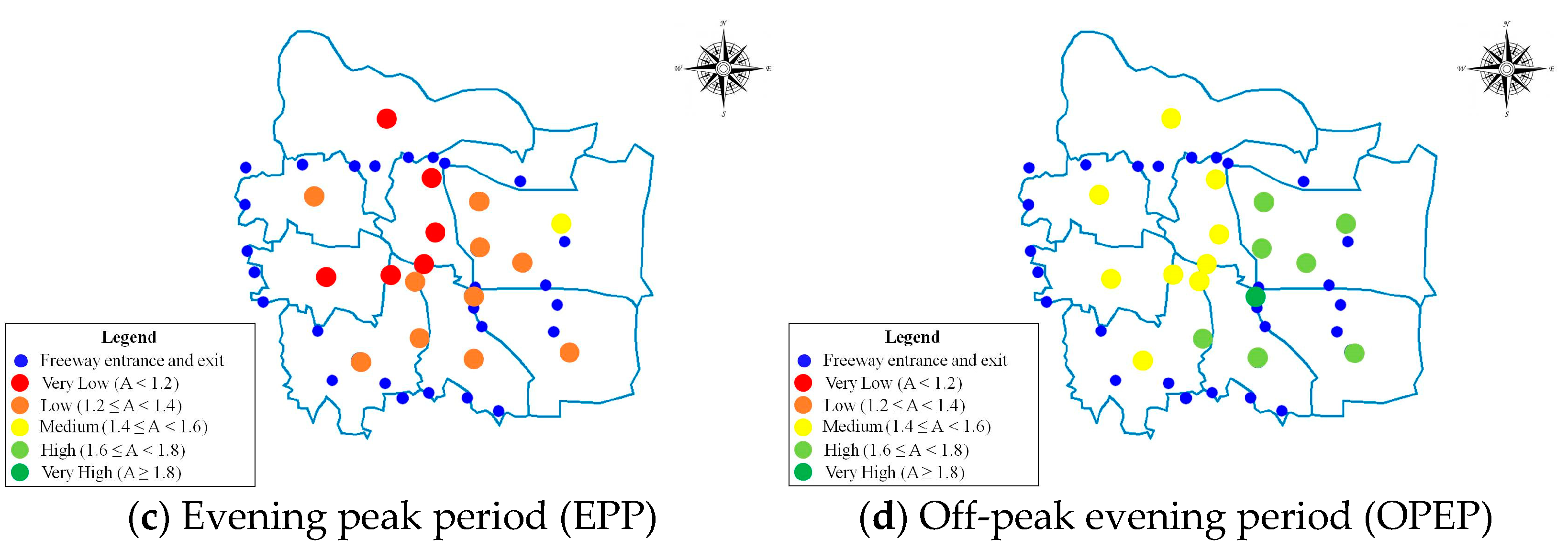
5.3. Dynamic Accessibility Analysis
6. Conclusions
Author Contributions
Funding
Institutional Review Board Statement
Informed Consent Statement
Data Availability Statement
Acknowledgments
Conflicts of Interest
References
- Stamatiadis, N.; Kirk, A.; Hartman, D.; Jasper, J.; Wright, S.; King, M.; Chellman, R. An Expanded Functional Classification System for Highways and Streets. In NCHRP Research Report; National Academy of Sciences, Engineering, and Medicine: Washington, DC, USA, 2017. [Google Scholar]
- García-Albertos, P.; Picornell, M.; Salas-Olmedo, M.H.; Gutiérrez, J. Exploring the potential of mobile phone records and online route planners for dynamic accessibility analysis. Transp. Res. Part A Policy Pr. 2019, 125, 294–307. [Google Scholar] [CrossRef]
- Shi, Y.; Blainey, S.P.; Sun, C.; Jing, P. A literature review on accessibility using bibliometric analysis techniques. J. Transp. Geogr. 2020, 87, 102810. [Google Scholar] [CrossRef]
- Xia, N.; Cheng, L.; Chen, S.; Wei, X.; Zong, W.; Li, M. Accessibility based on Gravity-Radiation model and Google Maps API: A case study in Australia. J. Transp. Geogr. 2018, 72, 178–190. [Google Scholar] [CrossRef]
- Ministry Housing and Urban-Rural Development of the China. Standard for Urban Comprehensive Transport System Planning (GB/T 51328-2018); Ministry Housing and Urban-Rural Development of the China: Beijing, China, 2018. [Google Scholar]
- Ray, B.L.; Schoen, J.; Jenior, P.; Knudsen, J.; Porter, R.J.; Leisch, J.P.; Mason, J.; Roess, R. Guidelines for Ramp and Interchange Spacing. In NCHRP Report; National Academies of Sciences, Engineering, and Medicine, Transportation Research Board: Washington, DC, USA, 2011. [Google Scholar]
- Páez, A.; Scott, D.M.; Morency, C. Measuring accessibility: Positive and normative implementations of various accessibility in-dicators. J. Transp. Geogr. 2012, 25, 141–153. [Google Scholar] [CrossRef]
- Van Wee, B. Accessible accessibility research challenges. J. Transp. Geogr. 2016, 51, 9–16. [Google Scholar] [CrossRef] [Green Version]
- Witlox, F. Beyond the Data Smog. Transp. Rev. 2015, 35, 245–249. [Google Scholar] [CrossRef]
- Bertolini, L.; Le Clercq, F.; Kapoen, L. Sustainable accessibility: A conceptual framework to integrate transport and land use plan-making. Two test-applications in the Netherlands and a reflection on the way forward. Transp. Policy 2005, 12, 207–220. [Google Scholar] [CrossRef]
- Tyrinopoulos, Y.; Antoniou, C. Public transit user satisfaction: Variability and policy implications. Transp. Policy 2008, 15, 260–272. [Google Scholar] [CrossRef]
- Geurs, K.T.; van Wee, B. Accessibility evaluation of land-use and transport strategies: Review and research directions. J. Transp. Geogr. 2004, 12, 127–140. [Google Scholar] [CrossRef]
- Handy, S.L.; A Niemeier, D. Measuring Accessibility: An Exploration of Issues and Alternatives. Environ. Plan. A Econ. Space 1997, 29, 1175–1194. [Google Scholar] [CrossRef]
- Zhou, X.; Ding, Y.; Wu, C.; Huang, J.; Hu, C. Measuring the Spatial Allocation Rationality of Service Facilities of Residential Areas Based on Internet Map and Location-Based Service Data. Sustainability 2019, 11, 1337. [Google Scholar] [CrossRef] [Green Version]
- Rong, P.; Zheng, Z.; Kwan, M.-P.; Qin, Y. Evaluation of the spatial equity of medical facilities based on improved potential model and map service API: A case study in Zhengzhou, China. Appl. Geogr. 2020, 119, 102192. [Google Scholar] [CrossRef]
- Foth, N.; Manaugh, K.; El-Geneidy, A.M. Towards equitable transit: Examining transit accessibility and social need in Toronto, Canada, 1996–2006. J. Transp. Geogr. 2013, 29, 1–10. [Google Scholar] [CrossRef]
- Weiss, D.J.; Nelson, A.; Gibson, H.S.; Temperley, W.; Peedell, S.; Lieber, A.; Hancher, M.; Poyart, E.; Belchior, S.; Fullman, N.; et al. A global map of travel time to cities to assess inequalities in accessibility in 2015. Nat. Cell Biol. 2018, 553, 333–336. [Google Scholar] [CrossRef]
- Beria, P.; Debernardi, A.; Ferrara, E. Measuring the long-distance accessibility of Italian cities. J. Transp. Geogr. 2017, 62, 66–79. [Google Scholar] [CrossRef]
- Guan, J.; Zhang, K.; Shen, Q.; He, Y. Dynamic Modal Accessibility Gap: Measurement and Application Using Travel Routes Data. Transp. Res. Part. D: Transp. Environ. 2020, 81, 102272. [Google Scholar] [CrossRef]
- Zhu, Y.J.; Hu, Y.J.; Collins, J.M. Estimating road network accessibility during a hurricane evacuation: A case study of hurricane Irma in Florida. Transp. Res. Part D Transp. Environ. 2020, 83, 102334. [Google Scholar] [CrossRef]
- Pritchard, J.P.; Tomasiello, D.B.; Giannotti, M.; Geursa, K. Potential impacts of bike-and-ride on job accessibility and spatial equity in São Paulo, Brazil. Transp. Res. Part A 2019, 121, 386–400. [Google Scholar] [CrossRef]
- Meire, S.; Derudder, B. A bimodal accessibility analysis of Australia through application programming interfaces. Transp. A: Transp. Sci. 2020, 16, 695–715. [Google Scholar] [CrossRef]
- Levinson, D.; Harder, K.; Bloomfield, J.; Winiarczyk, K. Weighting waiting: Evaluating the perception of in-vehicle travel time under moving and stopped conditions. Transp. Res. Rec. 2004, 1898, 61–68. [Google Scholar] [CrossRef] [Green Version]
- Malta, L.; Miyajima, C.; Kitaoka, N.; Takeda, K. Analysis of real-world driver’s frustration. IEEE T. Intell. Transp. 2011, 12, 109–118. [Google Scholar] [CrossRef]
- Saxena, N.; Rashidi, T.H.; Dixit, V.; Waller, S.T. Modelling the route choice behaviour under stop-&-go traffic for different car driver segments. Transp. Res. Part A Policy Pr. 2019, 119, 62–72. [Google Scholar] [CrossRef]
- Fosgerau, M.; Frejinger, E.; Karlstrom, A. A link based network route choice model with unrestricted choice set. Transp. Res. Part B Methodol. 2013, 56, 70–80. [Google Scholar] [CrossRef] [Green Version]
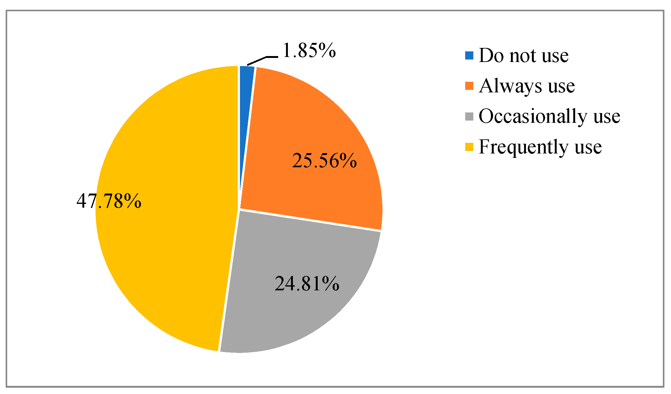
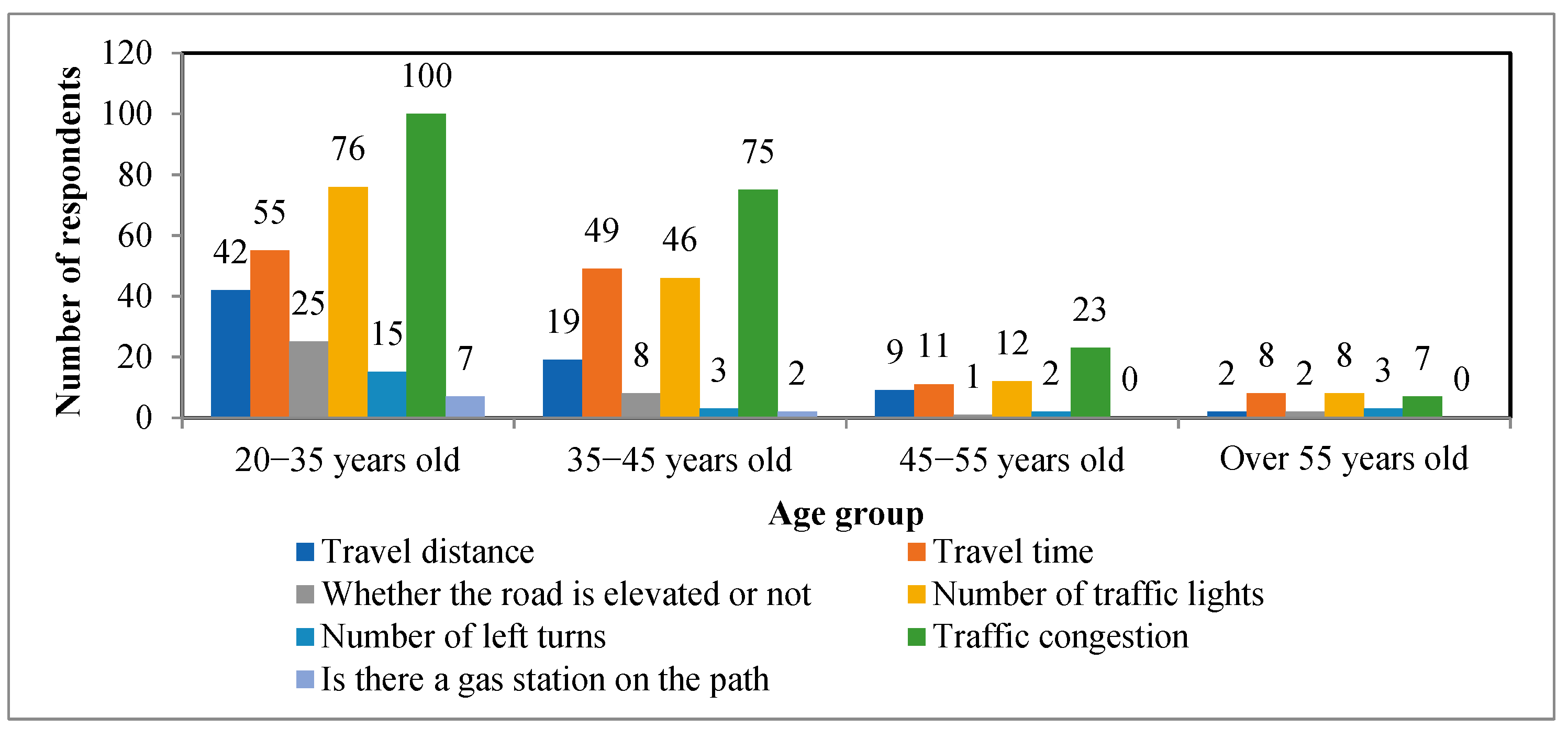
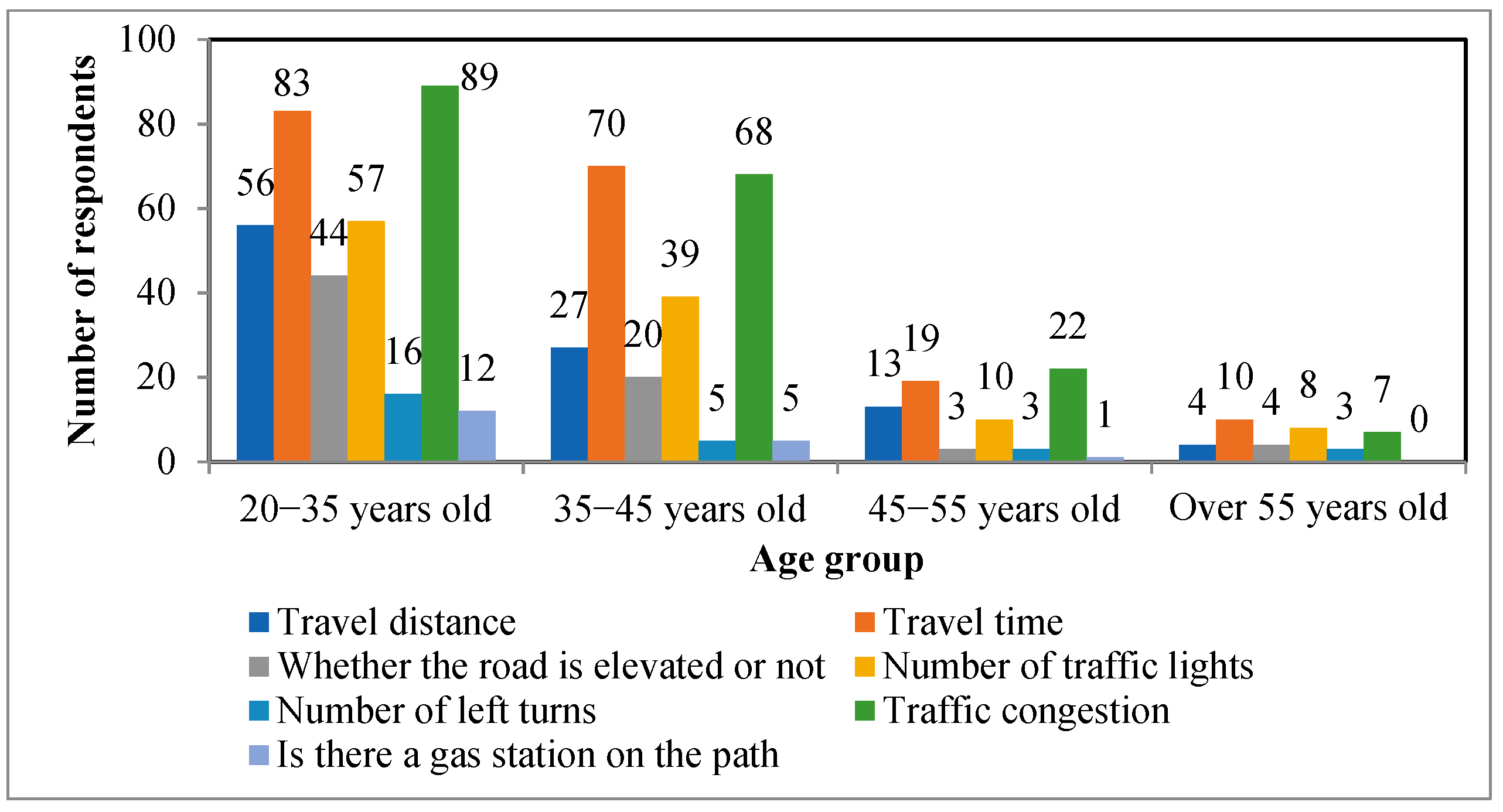


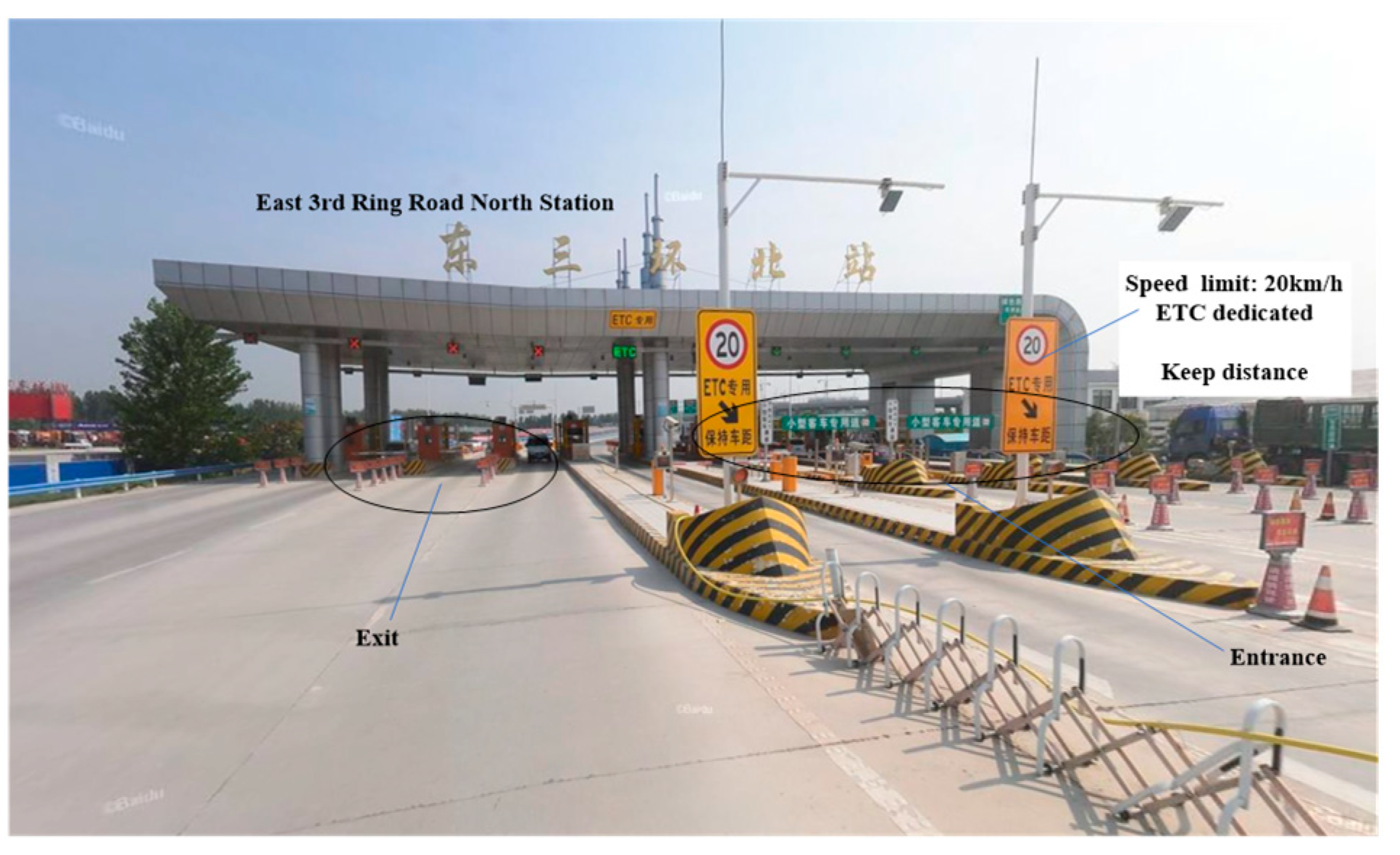



| Existing Studies | Impedance Function |
|---|---|
| [2] | Travel time |
| [18] | Exponential distance decay function |
| [19] | Travel time |
| [20] | Network distance |
| [21] | Negative exponential distance decay function |
| Freeways that form the Ring Freeway | Entrances and Exits on the Freeway |
|---|---|
| Zhengzhou Ring Expressway | Lotus Street; Science Avenue; Zhengshang Road; Zhongyuan West Road; Longhai West Road; Zhengmi Road; University South Road; Beijing–Guangzhou Freeway; Zheng Xin Freeway; East 3rd Circle Road |
| Zhengshao Freeway | Zheng Shao Freeway–Navigation Road connection Line |
| Zhengluan Freeway | South section of Songshan South Road |
| Airport Freeway | Zhongzhou Avenue; Navigation East Road; South 3rd Circle Road |
| Beijing–Hong Kong–Macao Freeway | South 3rd Circle Road; Navigation East Road; Longhai Freeway; Zhengkai Avenue |
| Lianhuo Freeway | East 3rd Circle Road North; Zhongzhou Avenue; Garden North Road; Cultural North Road; Beijing–Guangzhou Freeway; West 3rd Circle Road; West 4th Circle Road |
| Travel Hotspot | Abbreviation | Location (km, km) |
|---|---|---|
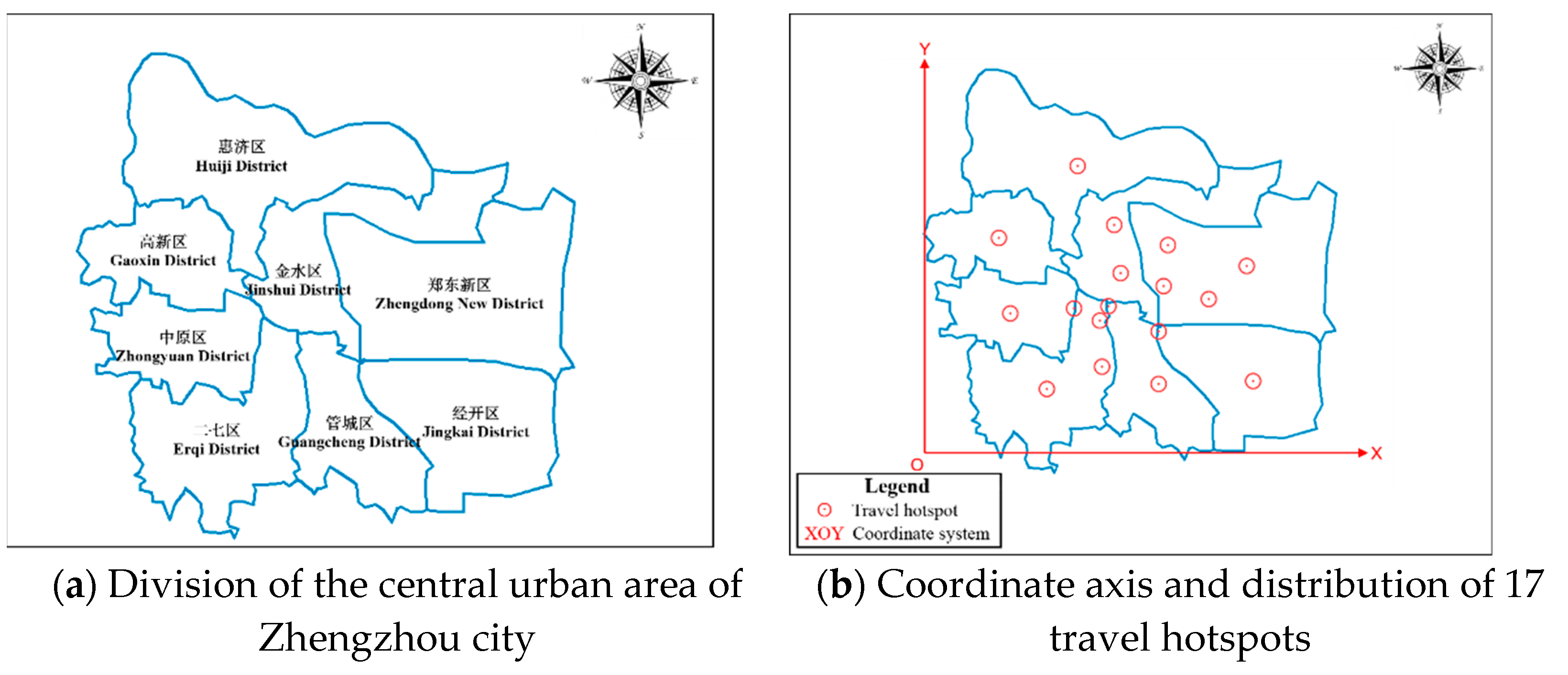
| Erqi Square Main Center | EQMC | (18.5, 12.3) |
| Zhengdong New District Main Center | ZDMC | (24.5, 13.4) |
| East Station Subcenter | ESSC | (28.7, 12.4) |
| Longhu Subcenter | LHSC | (24.8, 18.1) |
| Futa Subcenter | FTSC | (24.4, 8.2) |
| Bishagang Subcenter | BSGSC | (15.4, 11.3) |
| Huayuan Road Subcenter | HYSC | (19.9, 15.0) |
| Zhengzhou South Passenger Station | SPS | (17.9, 5.2) |
| Zhengzhou Railway Station | RS | (17.6, 10.9) |
| Centroid point of Huiji District | CPHJ | (15.6, 26.3) |
| Centroid point of Gaoxin District | CPGX | (7.0, 18.5) |
| Centroid point of Jinshui District | CPJS | (19.2, 20.0) |
| Centroid point of Zhengdong New District | CPZD | (32.7, 16.0) |
| Centroid point of Zhongyuan District | CPZY | (8.2, 11.0) |
| Centroid point of Erqi District | CPEQ | (12.0, 2.9) |
| Centroid point of Guancheng District | CPGC | (23.7, 3.9) |
| Centroid point of Jingkai District | CPJK | (33.6, 4.2) |
| Level | Accessibility Value |
|---|---|
| Very High | A ≥ 1.8 |
| High | 1.6 ≤ A < 1.8 |
| Medium | 1.4 ≤ A < 1.6 |
| Low | 1.2 ≤ A < 1.4 |
| Very Low | A < 1.2 |
Publisher’s Note: MDPI stays neutral with regard to jurisdictional claims in published maps and institutional affiliations. |
© 2021 by the authors. Licensee MDPI, Basel, Switzerland. This article is an open access article distributed under the terms and conditions of the Creative Commons Attribution (CC BY) license (http://creativecommons.org/licenses/by/4.0/).
Share and Cite
Yan, Y.; Guo, T.; Wang, D. Dynamic Accessibility Analysis of Urban Road-to-Freeway Interchanges Based on Navigation Map Paths. Sustainability 2021, 13, 372. https://doi.org/10.3390/su13010372
Yan Y, Guo T, Wang D. Dynamic Accessibility Analysis of Urban Road-to-Freeway Interchanges Based on Navigation Map Paths. Sustainability. 2021; 13(1):372. https://doi.org/10.3390/su13010372
Chicago/Turabian StyleYan, Yadan, Tianzhao Guo, and Dongwei Wang. 2021. "Dynamic Accessibility Analysis of Urban Road-to-Freeway Interchanges Based on Navigation Map Paths" Sustainability 13, no. 1: 372. https://doi.org/10.3390/su13010372
APA StyleYan, Y., Guo, T., & Wang, D. (2021). Dynamic Accessibility Analysis of Urban Road-to-Freeway Interchanges Based on Navigation Map Paths. Sustainability, 13(1), 372. https://doi.org/10.3390/su13010372


