Multi-Hazard Risk Assessment of Kathmandu Valley, Nepal
Abstract
1. Introduction
2. Materials and Methods
2.1. Study Area
2.2. Hazard Inventory Mapping
2.3. Factors Influencing Multi-Hazards
2.3.1. Distance from Fault
2.3.2. Slope
2.3.3. Aspect
2.3.4. Profile Curvature
2.3.5. Distance from Stream
2.3.6. Land Use Land Cover (LULC)
2.3.7. Lithology
2.3.8. Distance from Road
2.3.9. Annual Precipitation
2.3.10. Normalized Difference Vegetation Index (NDVI)
2.3.11. Elevation
2.3.12. Population Density
2.3.13. Distance from Fire Brigade
2.3.14. Distance from Gas Station
2.3.15. Distance from High-Voltage Transmission Lines
2.3.16. Distance from Electric Substation
2.3.17. Distance from Main Settlement
2.3.18. Distance from Old Settlement
2.3.19. Probability of Soil Liquefaction
2.3.20. Seismic Intensity
2.3.21. Dominant Building Type
2.4. Determination of Layer Weights
2.5. Hazard Assessment
2.5.1. Landslide Hazard Assessment
2.5.2. Flood Hazard Assessment
2.5.3. Fire Hazard Assessment
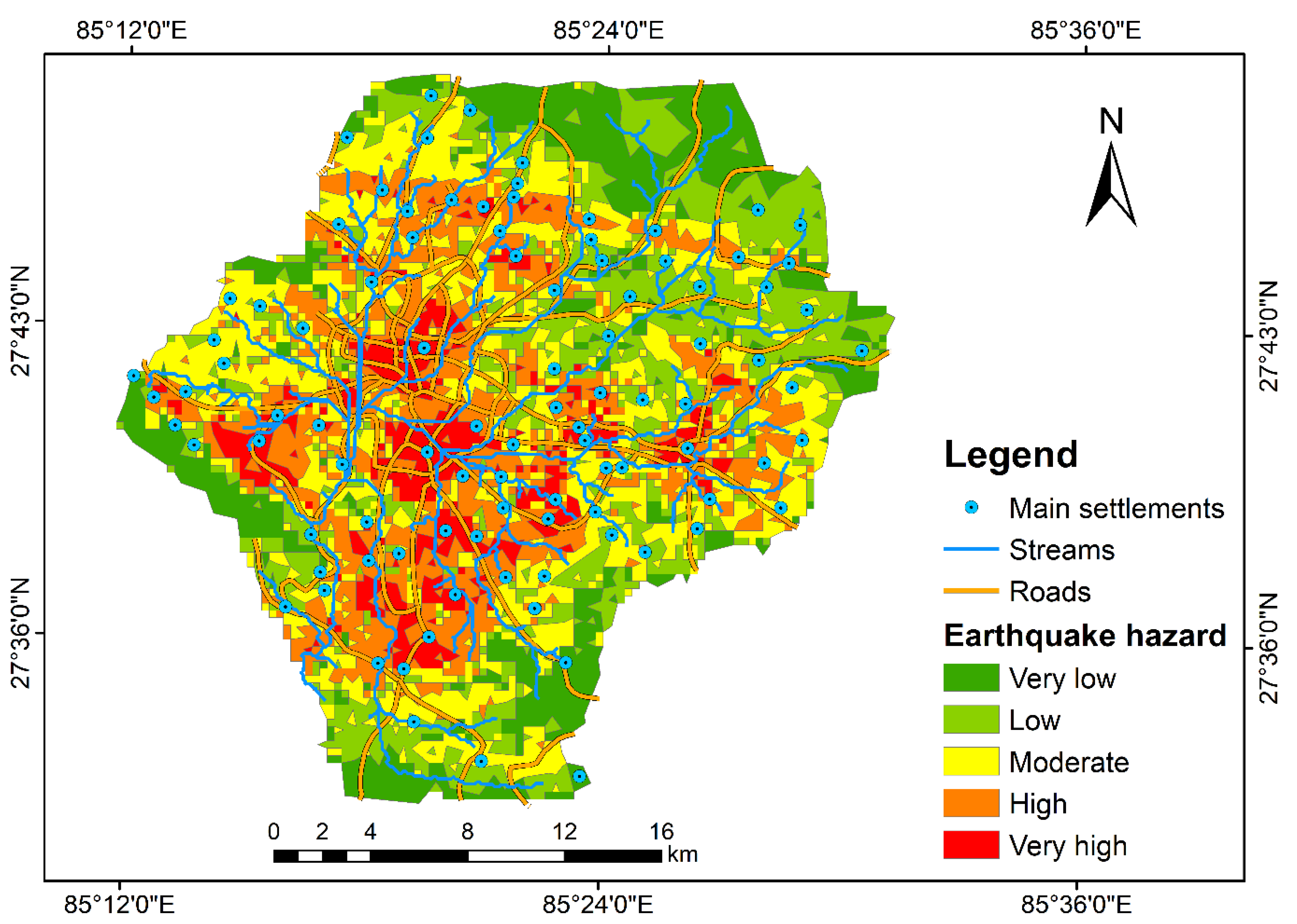
2.5.4. Earthquake Hazard Assessment
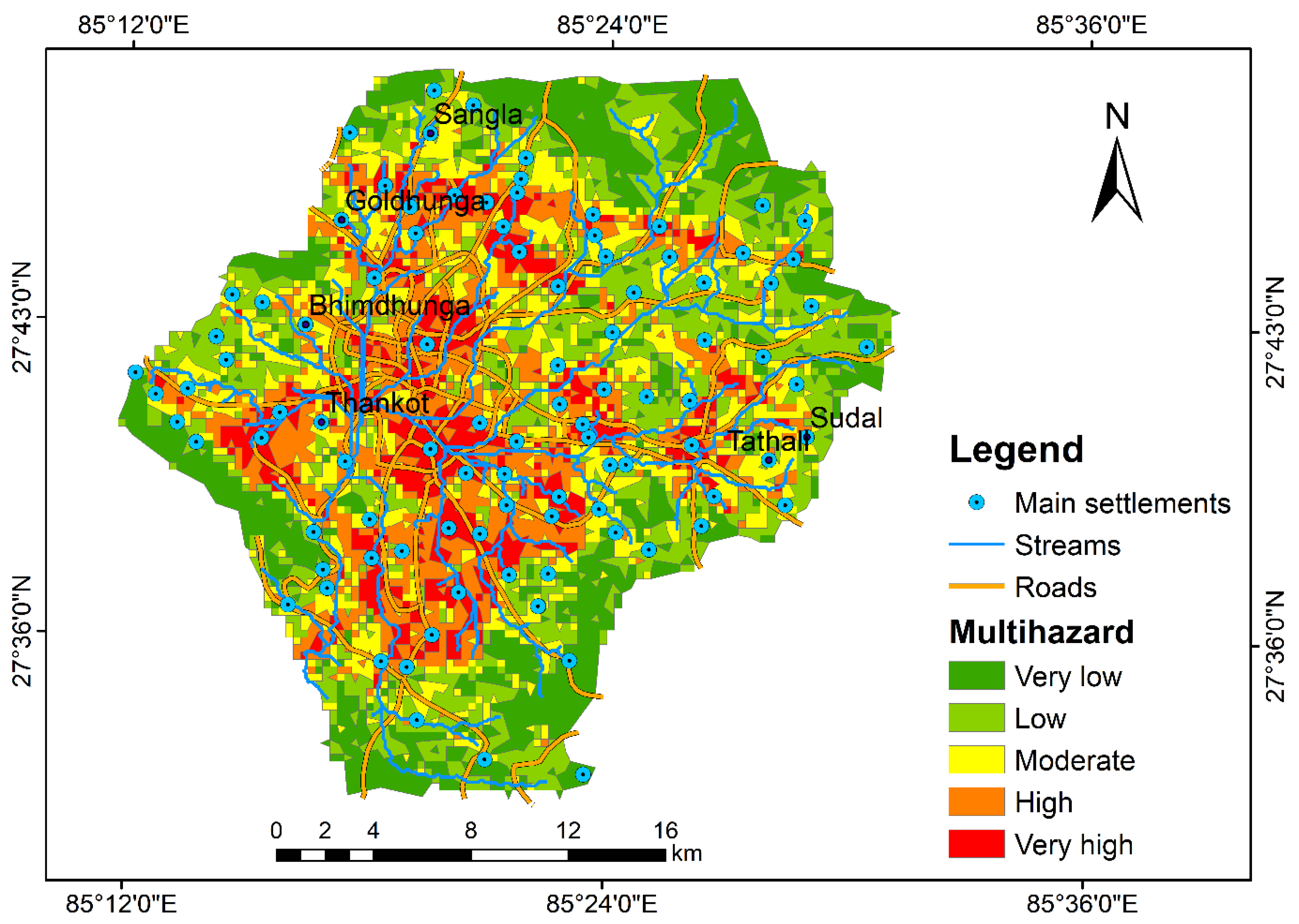
2.5.5. Multi-Hazard Risk Assessment
3. Results and Discussion
3.1. Individual Hazard Assessment
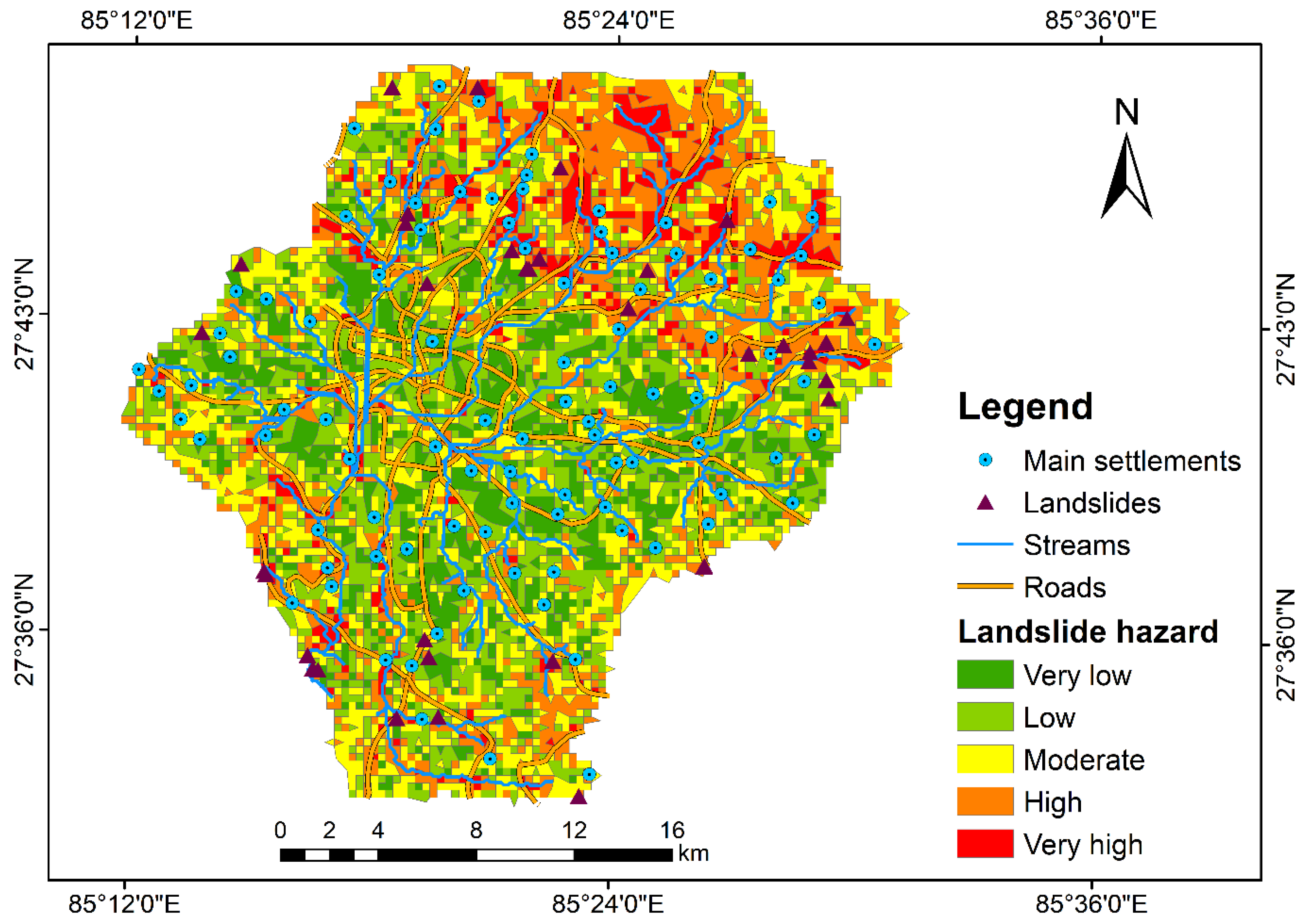
3.1.1. Landslide Hazard Assessment
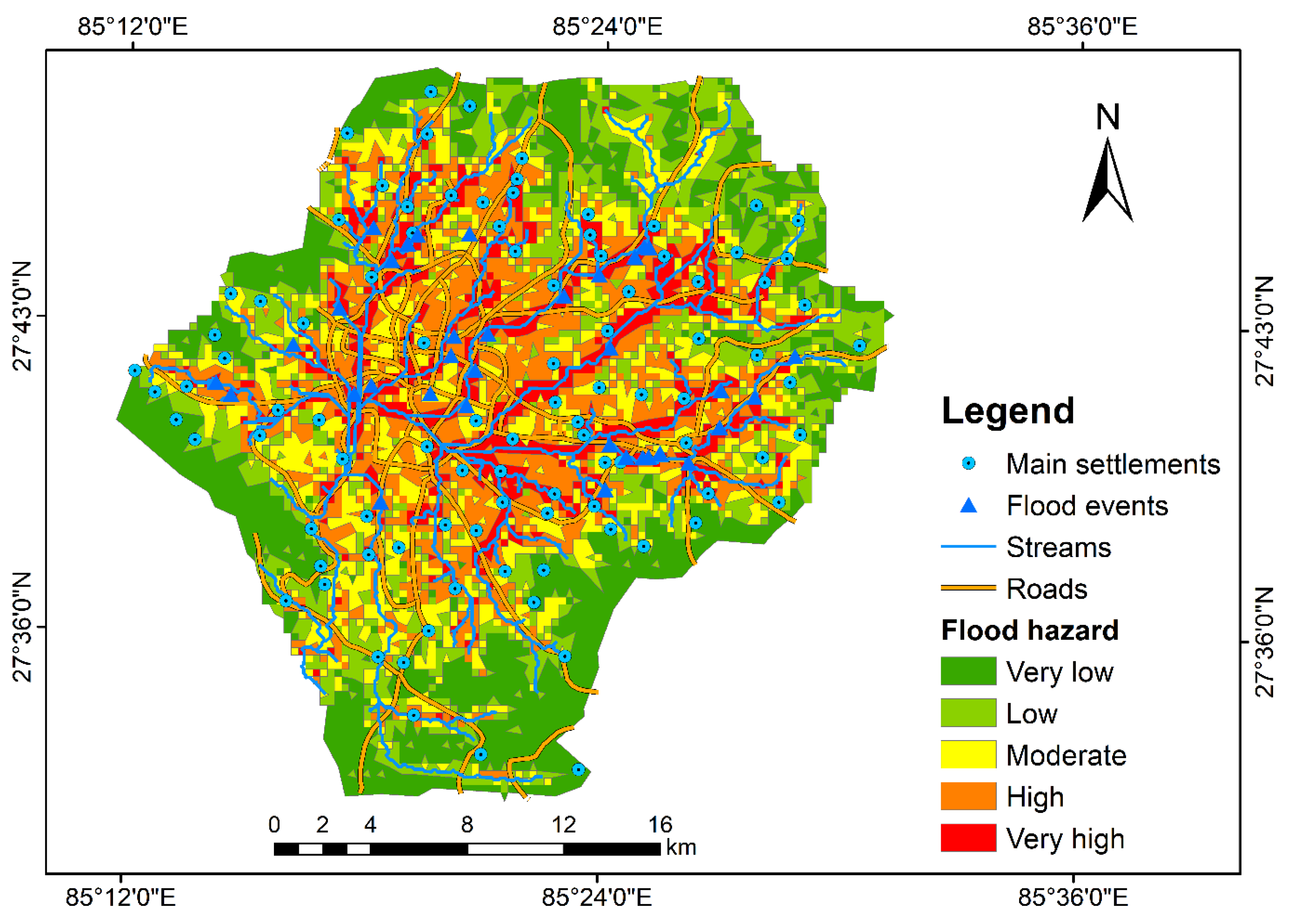
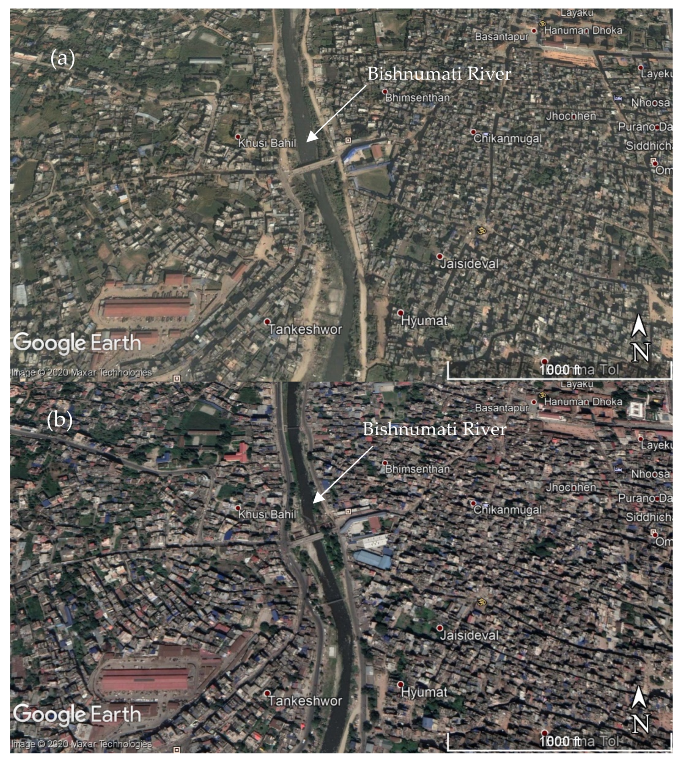
3.1.2. Flood Hazard Assessment
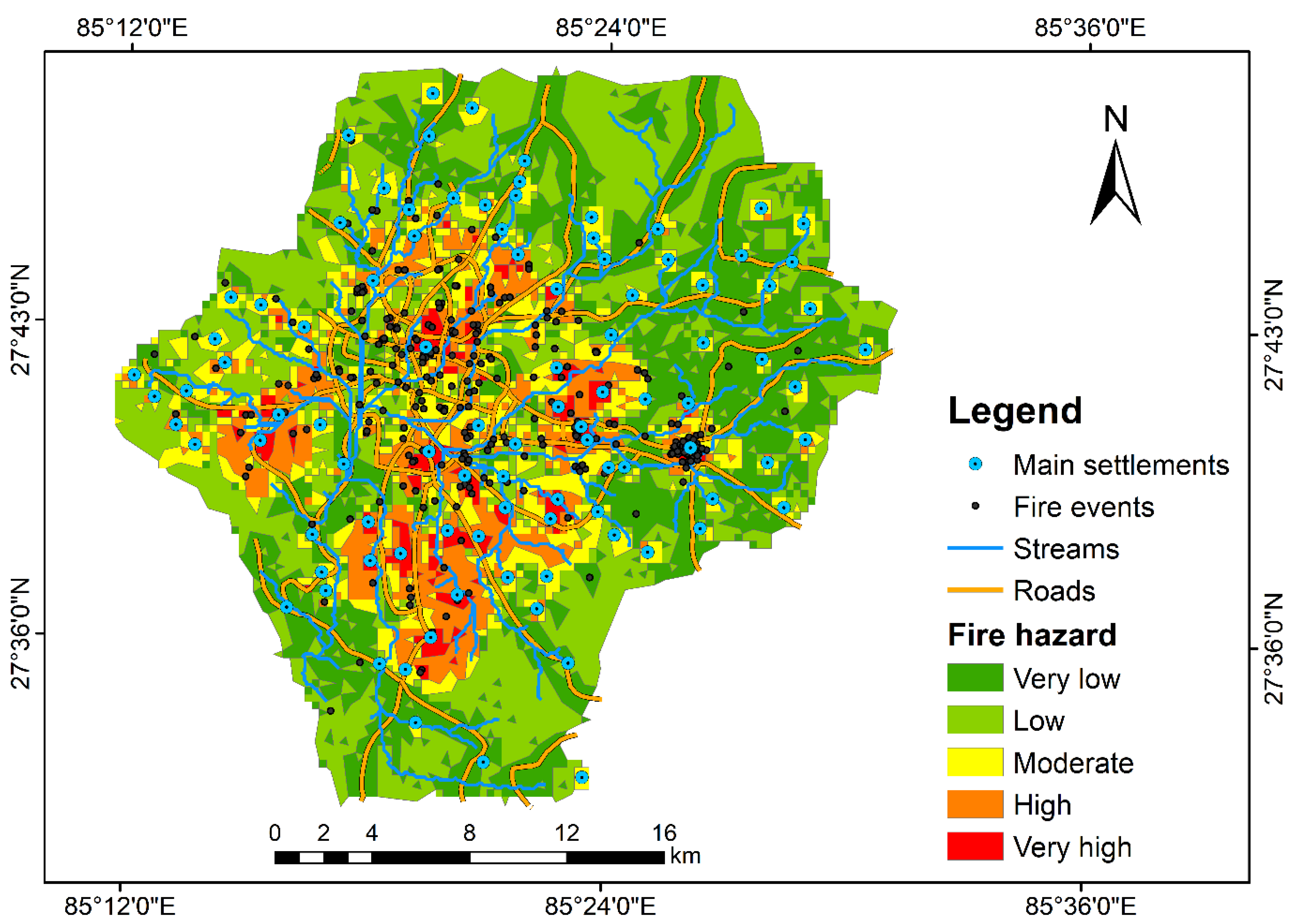
3.1.3. Fire Hazard Assessment
3.1.4. Earthquake Hazard Assessment
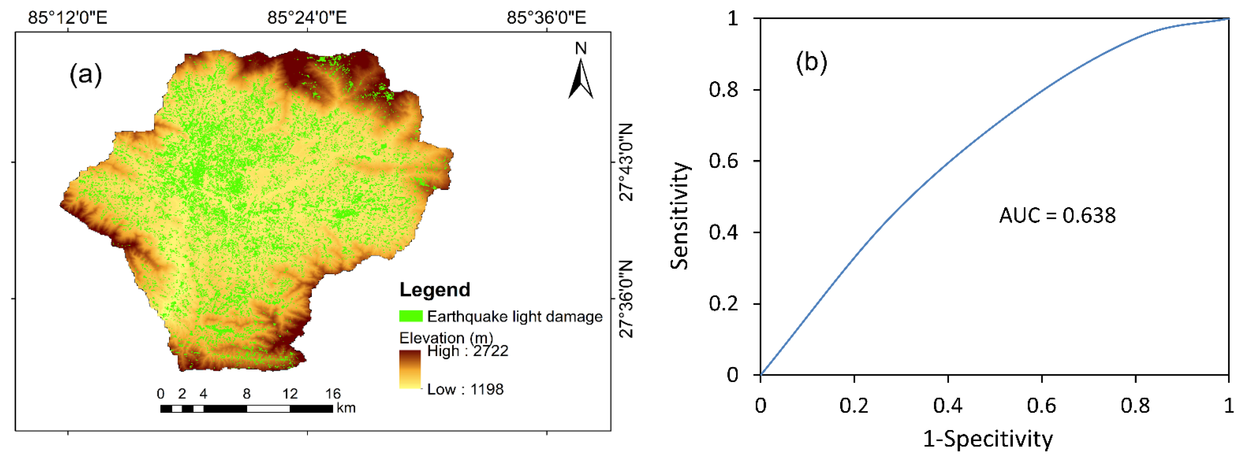
3.2. Validation of the Different Hazard Maps
3.3. Multi-Hazard Risk Assessment
4. Conclusions
Supplementary Materials
Author Contributions
Funding
Data Availability Statement
Acknowledgments
Conflicts of Interest
References
- World Bank. Hazards of Nature, Risks to Development: An IEG Evaluation of World Bank Assistance for Natural Disaster; World Bank: Washington, DC, USA, 2006. [Google Scholar]
- UNSIDR and CRED. Poverty & Death: Disaster Mortality, 1996–2015; UNSIDR and CRED: Brussels, Belgium, 2016. [Google Scholar]
- Gautam, D.; Thapa, S.; Pokhrel, S.; Lamichhane, S. Local level multi-hazard zonation of Nepal. Geomat. Nat. Hazards Risk 2021. [Google Scholar] [CrossRef]
- MoHA. Nepal Country Report; MoHA: Kathmandu, Nepal, 1999. [Google Scholar]
- MoHA. Nepal Disaster Report 2017: The Road to Sendai December; MoHA: Kathmandu, Nepal, 2017. [Google Scholar]
- UNDP/BCPR. A Global Report Reducing Disaster Risk-a Challenge for Development; UNDP/BCPR: Geneva, Switzerland, 2004. [Google Scholar]
- Shrestha, B.B.; Nakagawa, H. Hazard assessment of the formation and failure of the Sunkoshi landslide dam in Nepal. Nat. Hazards 2016, 82, 2029–2049. [Google Scholar] [CrossRef]
- Lacroix, P. Landslides triggered by the Gorkha earthquake in the Langtang valley, volumes and initiation processes. Earth Planets Space 2016, 68, 46. [Google Scholar] [CrossRef]
- Bhochhibhoya, S.; Adhikari, P.; Adhikari, P.; Gautam, D. Probabilistic seismic liquefaction hazard assessment of Kathmandu valley, Nepal. Geomat. Nat. Hazards Risk 2020, 11, 259–271. [Google Scholar] [CrossRef]
- Gautam, D.; de Magistris, F.S.; Fabbrocino, G. Soil liquefaction in Kathmandu valley due to 25 April 2015 Gorkha, Nepal earthquake. Soil Dyn. Earthq. Eng. 2017, 97, 37–47. [Google Scholar] [CrossRef]
- Rajendran, C.P. Constraints on previous earthquakes from the liquefaction sites in the Kathmandu Valley associated with the 2015 Gorkha earthquake and their regional implications. Quat. Int. 2020. [Google Scholar] [CrossRef]
- Chhetri, S.K.; Kayastha, P. Manifestation of an analytic hierarchy process (AHP) model on fire potential zonation mapping in Kathmandu metropolitan City, Nepal. ISPRS Int. J. Geo Inf. 2015, 4, 400–417. [Google Scholar] [CrossRef]
- Chaulagain, H.; Rodrigues, H.; Silva, V.; Spacone, E.; Varum, H. Seismic risk assessment and hazard mapping in Nepal. Nat. Hazards 2015, 78, 583–602. [Google Scholar] [CrossRef]
- Chaulagain, H.; Rodrigues, H.; Silva, V.; Spacone, E.; Varum, H. Earthquake loss estimation for the Kathmandu Valley. Bull. Earthquake Eng. 2016, 14, 59–88. [Google Scholar]
- Sakai, T.; Gajurel, A.P.; Tabata, H. Seismites in the Pleistocene succession and recurrence period of large earthquakes in the Kathmandu Valley, Nepal. Geoenviron. Disasters 2015, 2, 1–17. [Google Scholar] [CrossRef]
- Mugnier, J.L.; Huyghe, P.; Gajurel, A.P.; Upreti, B.N.; Jouanne, F. Seismites in the Kathmandu basin and seismic hazard in central Himalaya. Tectonophysics 2011, 509, 33–49. [Google Scholar] [CrossRef]
- Bajracharya, S.R.; Shrestha, M.S.; Shrestha, A.B. Assessment of high-resolution satellite rainfall estimation products in a streamflow model for flood prediction in the Bagmati basin, Nepal. J. Flood Risk Manag. 2017, 10, 5–16. [Google Scholar] [CrossRef]
- Gautam, D.K.; Kharbuja, R.G. Flood hazard mapping of Bagmati River in Kathmandu valley using geo-informatics tools. J. Hydrol. Meteorol. 2006, 3, 1–9. [Google Scholar]
- Dahal, R.K.; Hasegawa, S.; Nonomura, A.; Yamanaka, M.; Dhakal, S.; Paudyal, P. Predictive modelling of rainfall-induced landslide hazard in the Lesser Himalaya of Nepal based on weights-of-evidence. Geomorphology 2008, 102, 496–510. [Google Scholar] [CrossRef]
- Hasegawa, S.; Dahal, R.K.; Yamanaka, M.; Bhandary, N.P.; Yatabe, R.; Inagaki, H. Causes of large-scale landslides in the Lesser Himalaya of central Nepal. Environ. Geol. 2009, 57, 1423–1434. [Google Scholar] [CrossRef]
- Timilsina, M.; Bhandary, N.P.; Dahal, R.K.; Yatabe, R. Distribution probability of large-scale landslides in central Nepal. Geomorphology 2014, 226, 236–248. [Google Scholar] [CrossRef]
- Bathrellos, G.D.; Karymbalis, E.; Skilodimou, H.D.; Gaki-Papanastassiou, K.; Baltas, E.A. Urban flood hazard assessment in the basin of Athens Metropolitan city, Greece. Environ. Earth Sci. 2016, 75, 319. [Google Scholar] [CrossRef]
- Artan, G.; Gadain, H.; Smith, J.L.; Asante, K.; Bandaragoda, C.J.; Verdin, J.P. Adequacy of satellite derived rainfall data for stream flow modeling. Nat. Hazards 2007, 43, 167–185. [Google Scholar] [CrossRef]
- Todini, E. Hydrological catchment modelling: Past, present and future. Hydrol. Earth Syst. Sci. 2007, 11, 468–482. [Google Scholar] [CrossRef]
- Mishra, K.; Sinha, R. Flood risk assessment in the Kosi megafan using multi-criteria decision analysis: A hydro-geomorphic approach. Geomorphology 2020, 350, 106861. [Google Scholar] [CrossRef]
- Aryal, D.; Wang, L.; Adhikari, T.R.; Zhou, J.; Li, X.; Shrestha, M.; Wang, Y.; Chen, D. A Model-Based Flood Hazard Mapping on the Southern Slope of Himalaya. Water 2020, 12, 540. [Google Scholar] [CrossRef]
- Ornthammarath, T.; Warnitchai, P.; Chan, C.-H.; Wang, Y.; Shi, X.; Nguyen, P.H.; Nguyen, L.M.; Kosuwan, S.; Thant, M. Probabilistic seismic hazard assessments for Northern Southeast Asia (Indochina): Smooth seismicity approach. Earthq. Spectra 2020, 36, 69–90. [Google Scholar] [CrossRef]
- Jena, R.; Pradhan, B.; Beydoun, G.; Alamri, A.M.; Ardiansyah, N.; Sofyan, H. Earthquake hazard and risk assessment using machine learning approaches at Palu, Indonesia. Sci. Total Environ. 2020, 749, 141582. [Google Scholar] [CrossRef] [PubMed]
- Yariyan, P.; Zabihi, H.; Wolf, I.D.; Karami, M.; Amiriyan, S. Earthquake risk assessment using an integrated Fuzzy Analytic Hierarchy Process with Artificial Neural Networks based on GIS: A case study of Sanandaj in Iran. Int. J. Disaster Risk Reduct. 2020, 50, 101705. [Google Scholar] [CrossRef]
- He, H.; Hu, D.; Sun, Q.; Zhu, L.; Liu, Y. A landslide susceptibility assessment method based on GIS technology and an AHP-weighted information content method: A case study of southern Anhui, China. ISPRS Int. J. Geo Inf. 2019, 8, 266. [Google Scholar] [CrossRef]
- Ambrosi, C.; Strozzi, T.; Scapozza, C.; Wegmüller, U. Landslide hazard assessment in the Himalayas (Nepal and Bhutan) based on Earth-Observation data. Eng. Geol. 2018, 237, 217–228. [Google Scholar] [CrossRef]
- Pourghasemi, H.R.; Moradi, H.R.; Fatemi Aghda, S.M. Landslide susceptibility mapping by binary logistic regression, analytical hierarchy process, and statistical index models and assessment of their performances. Nat. Hazards 2013, 69, 749–779. [Google Scholar] [CrossRef]
- Chen, W.; Hong, H.; Panahi, M.; Shahabi, H.; Wang, Y.; Shirzadi, A.; Pirasteh, S.; Alesheikh, A.A.; Khosravi, K.; Panahi, S.; et al. Spatial Prediction of Landslide Susceptibility Using GIS-Based Data Mining Techniques of ANFIS with Whale Optimization Algorithm (WOA) and Grey Wolf Optimizer (GWO). Appl. Sci. 2019, 9, 3755. [Google Scholar] [CrossRef]
- Shi, L.; Zhang, R.; Xie, Q.; Fu, L. Improving analytic hierarchy process applied to fire risk analysis of public building. Chin. Sci. Bull. 2009, 54, 1442–1450. [Google Scholar] [CrossRef]
- UNEP. United Nations Conference on Environment & Development Rio de Janerio, Brazil, 3 to 14 June 1992 AGENDA 21; UNEP: Rio de Janerio, Brazil, 1992. [Google Scholar]
- UN. Johannsburg Plan of Implementation of the World Summit on Sustainable Development; Technical Report; United Nations Publications: New York, NY, USA, 2002. [Google Scholar]
- Barua, U.; Akhter, M.S.; Ansary, M.A. District-wise multi-hazard zoning of Bangladesh. Nat. Hazards 2016, 82, 1895–1918. [Google Scholar] [CrossRef]
- Bathrellos, G.D.; Skilodimou, H.D.; Chousianitis, K.; Youssef, A.M.; Pradhan, B. Suitability estimation for urban development using multi-hazard assessment map. Sci. Total Environ. 2017, 575, 119–134. [Google Scholar] [CrossRef]
- Chimidi, G.; Raghuvanshi, T.K.; Suryabhagavan, K.V. Landslide hazard evaluation and zonation in and around Gimbi town, western Ethiopia—a GIS-based statistical approach. Appl. Geomat. 2017, 9, 219–236. [Google Scholar] [CrossRef]
- Mengistu, F.; Suryabhagavan, K.V.; Raghuvanshi, T.K.; Lewi, E. Landslide Hazard Zonation and Slope Instability Assessment using Optical and InSAR Data: A Case Study from Gidole Town and its Surrounding Areas, Southern Ethiopia. Remote Sens. Land 2019, 3, 1–14. [Google Scholar] [CrossRef]
- Liu, Y.-C.; Chen, C.-S. A new approach for application of rock mass classification on rock slope stability assessment. Eng. Geol. 2007, 89, 129–143. [Google Scholar] [CrossRef]
- Lari, S.; Frattini, P.; Crosta, G.B. A probabilistic approach for landslide hazard analysis. Eng. Geol. 2014, 182, 3–14. [Google Scholar] [CrossRef]
- Straub, D.; Schubert, M. Modeling and managing uncertainties in rock-fall hazards. Georisk Assess. Manag. Risk Eng. Syst. Geohazards 2008, 2, 1–15. [Google Scholar] [CrossRef]
- Pourghasemi, H.R.; Gayen, A.; Edalat, M.; Zarafshar, M.; Tiefenbacher, J.P. Is multi-hazard mapping effective in assessing natural hazards and integrated watershed management? Geosci. Front. 2020, 11, 1203–1217. [Google Scholar] [CrossRef]
- Pradhan, B. A comparative study on the predictive ability of the decision tree, support vector machine and neuro-fuzzy models in landslide susceptibility mapping using GIS. Comput. Geosci. 2013, 51, 350–365. [Google Scholar] [CrossRef]
- Saaty, T.L. Decision making with the Analytic Hierarchy Process. Sci. Iran. 2002, 9, 215–229. [Google Scholar] [CrossRef]
- Meten, M.; PrakashBhandary, N.; Yatabe, R. Effect of Landslide Factor Combinations on the Prediction Accuracy of Landslide Susceptibility Maps in the Blue Nile Gorge of Central Ethiopia. Geoenviron. Disasters 2015, 2. [Google Scholar] [CrossRef]
- Shit, P.K.; Bhunia, G.S.; Maiti, R. Potential landslide susceptibility mapping using weighted overlay model (WOM). Model. Earth Syst. Environ. 2016, 2, 21. [Google Scholar] [CrossRef]
- Pardeshi, S.D.; Autade, S.E.; Pardeshi, S.S. Landslide hazard assessment: Recent trends and techniques. Springerplus 2013, 2, 1–11. [Google Scholar] [CrossRef] [PubMed]
- Sakai, H. Stratigraphic division and sedimentary facies of the Kathmandu Basin Group, central Nepal. J. Nepal Geol. Soc. 2001, 25, 19–32. [Google Scholar]
- USGS. Earth explorer data available on the World Wide Web, United State Geological Survey (USGS). Available online: https://earthexplorer.usgs.gov/ (accessed on 10 May 2020).
- Lamichhane, S.; Shakya, N.M. Integrated assessment of climate change and land use change impacts on hydrology in the Kathmandu Valley watershed, Central Nepal. Water 2019, 11, 2059. [Google Scholar] [CrossRef]
- DMG. Engineering and Environmental Geological Map of the Kathmandu Valley,’ Scale 1:50,000, Department of Mines and Geology, Kathmandu, First Edition Kathmandu; DMG: Kathmandu, Nepal, 1998. [Google Scholar]
- Google Map Kathmandu Valley. Available online: https://www.google.com/maps/@27.6659389,85.4091329,11.56z?hl=en (accessed on 12 November 2020).
- DHM. Hydrological and Meterological Records of Nepal, Department of Hydrology and Meteorology: Government of Nepal, Ministry of Water Resources, Kathmandu; DHM: Kathmandu, Nepal, 2015. [Google Scholar]
- CBS. Nepal Population Report 2011, Government of Nepal Ministry of Health and Population, Kathmandu, Nepal; CBS: Ramshahpath, Kathmandu, Nepal, 2012. [Google Scholar]
- JICA; MoHA. The Study on Earthquake Disaster Mitigation in the Kathmandu Valley, Kingdom of Nepal Final Report, Volume I; MoHA: Kathmandu, Nepal, 2002. [Google Scholar]
- Pourghasemi, H.R.; Pradhan, B.; Gokceoglu, C. Application of fuzzy logic and analytical hierarchy process (AHP) to landslide susceptibility mapping at Haraz watershed, Iran. Nat. Hazards 2012, 63, 965–996. [Google Scholar] [CrossRef]
- Pourghasemi, H.R.; Gayen, A.; Panahi, M.; Rezaie, F.; Blaschke, T. Multi-hazard probability assessment and mapping in Iran. Sci. Total Environ. 2019, 692, 556–571. [Google Scholar] [CrossRef]
- Yalcin, A. GIS-based landslide susceptibility mapping using analytical hierarchy process and bivariate statistics in Ardesen (Turkey): Comparisons of results and confirmations. CATENA 2008, 72, 1–12. [Google Scholar] [CrossRef]
- Galli, M.; Ardizzone, F.; Cardinali, M.; Guzzetti, F.; Reichenbach, P. Comparing landslide inventory maps. Geomorphology 2008, 94, 268–289. [Google Scholar] [CrossRef]
- Stocking, M.A. Relief analysis and Soil Erosion in Rhodesia Using Multi-Variate Techniques. Z. Geomorphol. 1972, 16, 432–443. [Google Scholar]
- van Westen, C.J.; Castellanos, E.; Kuriakose, S.L. Spatial data for landslide susceptibility, hazard, and vulnerability assessment: An overview. Eng. Geol. 2008, 102, 112–131. [Google Scholar] [CrossRef]
- Chen, W.; Li, Y. GIS-based evaluation of landslide susceptibility using hybrid computational intelligence models. Catena 2020, 195, 104777. [Google Scholar] [CrossRef]
- Bennett, B.; Leonard, M.; Deng, Y.; Westra, S. An empirical investigation into the effect of antecedent precipitation on flood volume. J. Hydrol. 2018, 567, 435–445. [Google Scholar] [CrossRef]
- Gigović, L.; Pamučar, D.; Bajić, Z.; Drobnjak, S. Application of GIS-Interval Rough AHP Methodology for Flood Hazard Mapping in Urban Areas. Water 2017, 9, 360. [Google Scholar] [CrossRef]
- El-Harbawi, M.; Al-Mubaddel, F. Risk of Fire and Explosion in Electrical Substations Due to the Formation of Flammable Mixtures. Sci. Rep. 2020, 10, 6295. [Google Scholar] [CrossRef] [PubMed]
- Gautam, D.; Fabbrocino, G.; Santucci de Magistris, F. Derive empirical fragility functions for Nepali residential buildings. Eng. Struct. 2018, 171, 617–628. [Google Scholar] [CrossRef]
- Saaty, T.L. The Analytic Hierarchy Process: Planning, Priority Setting, Resource Allocation; McGraw-Hill Book Co: New York, NY, USA, 1980. [Google Scholar]
- Saaty, T.L.; Vargas, L.G. Models, Methods, Concepts and Applications of the Analytic Hierarchy Process; Springer: Berlin/Heidelberg, Germany, 2001. [Google Scholar]
- Malczewski, J. GIS and Multicriteria Decision Analysis; John Wiley & Sons: New York, NY, USA, 1999; ISBN 978-0-471-32944-2. [Google Scholar]
- Saaty, T.L. How to make a decision: The analytic hierarchy process. Eur. J. Oper. Res. 1990, 48, 9–26. [Google Scholar] [CrossRef]
- Chaulagain, H.; Gautam, D.; Rodrigues, H. Revisiting Major Historical Earthquakes in Nepal: Overview of 1833, 1934, 1980, 1988, 2011, and 2015 Seismic Events. In Impacts and Insights of Gorkha Earthquake; Gautam, D., Rodrigues, H., Eds.; Elsevier: Boston, MA, USA, 2018; Volume I, pp. 1–17. ISBN 9780128128084. [Google Scholar]
- Dai, F.; Lee, C. Landslide characteristics and slope instability modeling using GIS, Lantau Island, Hong Kong. Geomorphology 2002, 42, 213–228. [Google Scholar] [CrossRef]
- Costa, J.E. Hydraulics and basin morphometry of the largest flash floods in the conterminous United States. J. Hydrol. 1987, 93, 313–338. [Google Scholar] [CrossRef]
- DWIDM. Disaster review 1973 to 2016; DWIDM: Kathmandu, Nepal, 2017. [Google Scholar]
- Gautam, D.; Forte, G.; Rodrigues, H. Site effects and associated structural damage analysis in Kathmandu Valley, Nepal. Earthq. Struct. 2016, 10, 1013–1032. [Google Scholar] [CrossRef]
- Swets, J. Measuring the accuracy of diagnostic systems. Science 1988, 240, 1285–1293. [Google Scholar] [CrossRef]
- Yesilnacar, E.; Topal, T. Landslide susceptibility mapping: A comparison of logistic regression and neural networks methods in a medium scale study, Hendek region (Turkey). Eng. Geol. 2005, 79, 251–266. [Google Scholar] [CrossRef]
- GoN. Nepal Disaster Risk Reduction Portal Kathmandu, Nepal. Available online: http://drrportal.gov.np/ (accessed on 7 November 2020).
- NASA. NASA-Generated Damage Map to Assist with 2015 Gorkha, Nepal Earthquake Disaster Response. Available online: https://www.nasa.gov/jpl/nasa-generated-damage-map-to-assist-with-2015-gorkha-nepal-earthquake-disaster (accessed on 1 November 2020).
- Saaty, T.L. A scaling method for priorities in hierarchical structures. J. Math. Psychol. 1977, 15, 234–281. [Google Scholar] [CrossRef]
- Saaty, T.L. The Fundamentals of Decision Making and Priority Theory with the Analytic Hierarchy Process, 2nd ed.; RWS Publications: Pitsburg, PA, USA, 2000; Volume VI. [Google Scholar]
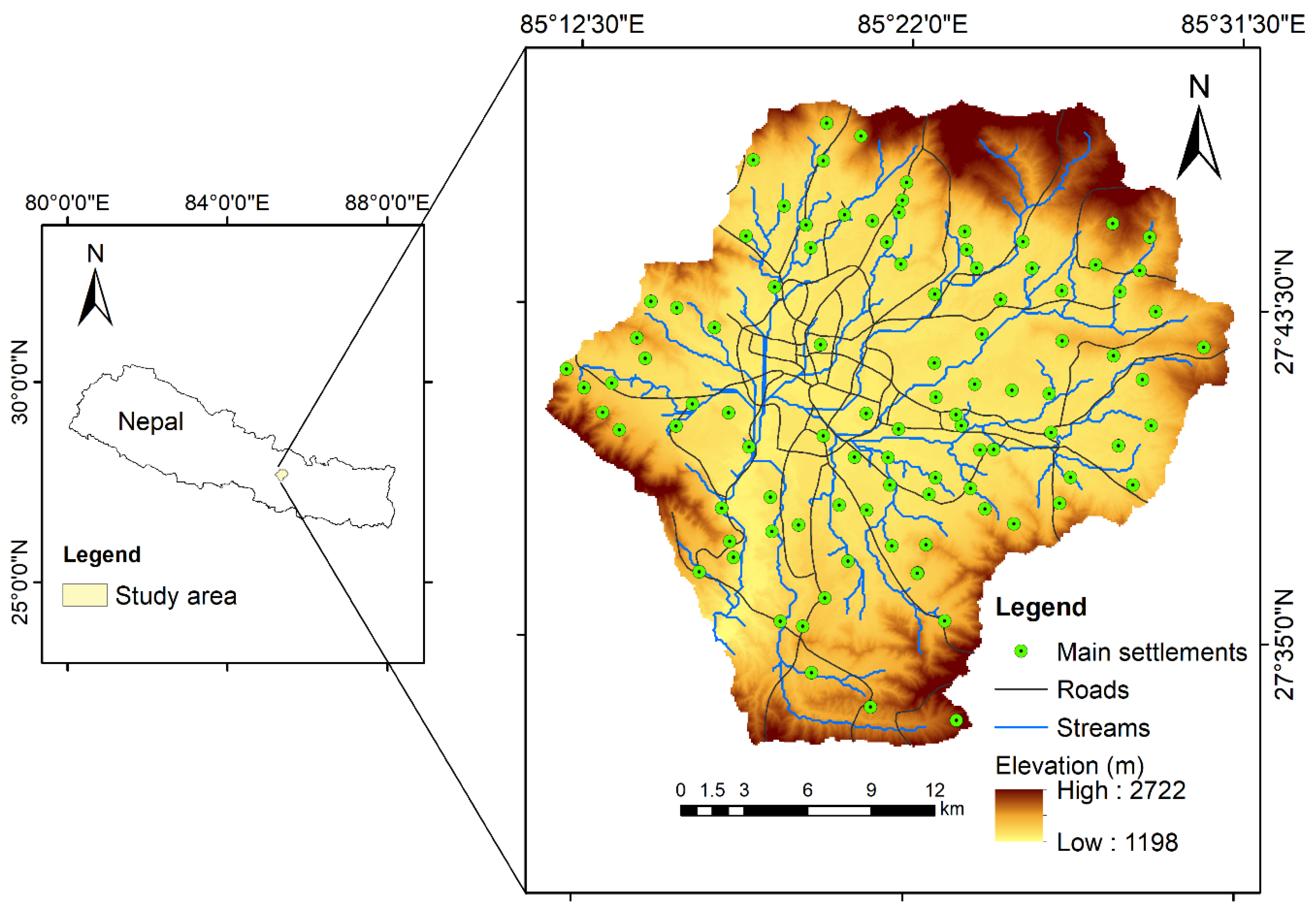

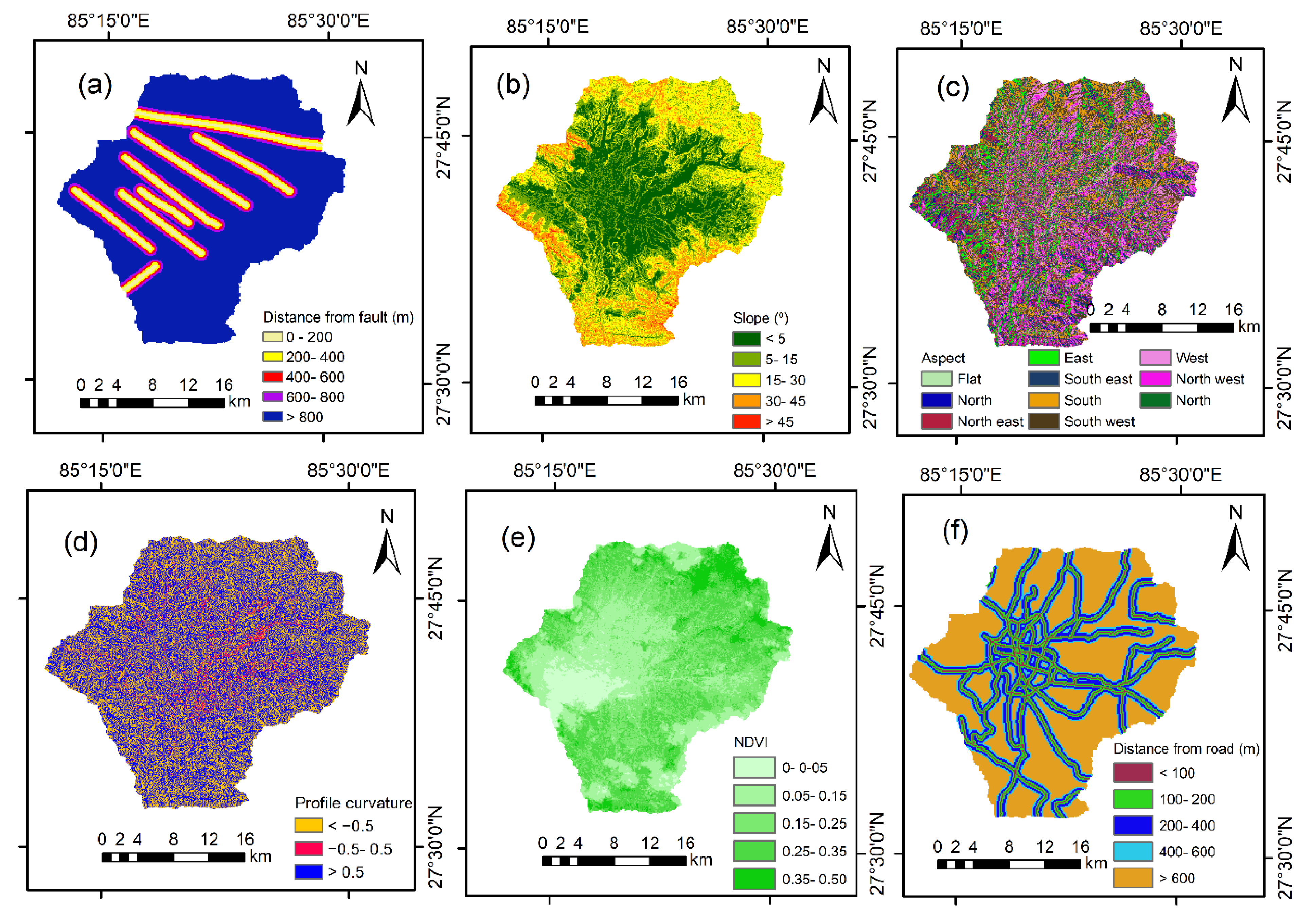

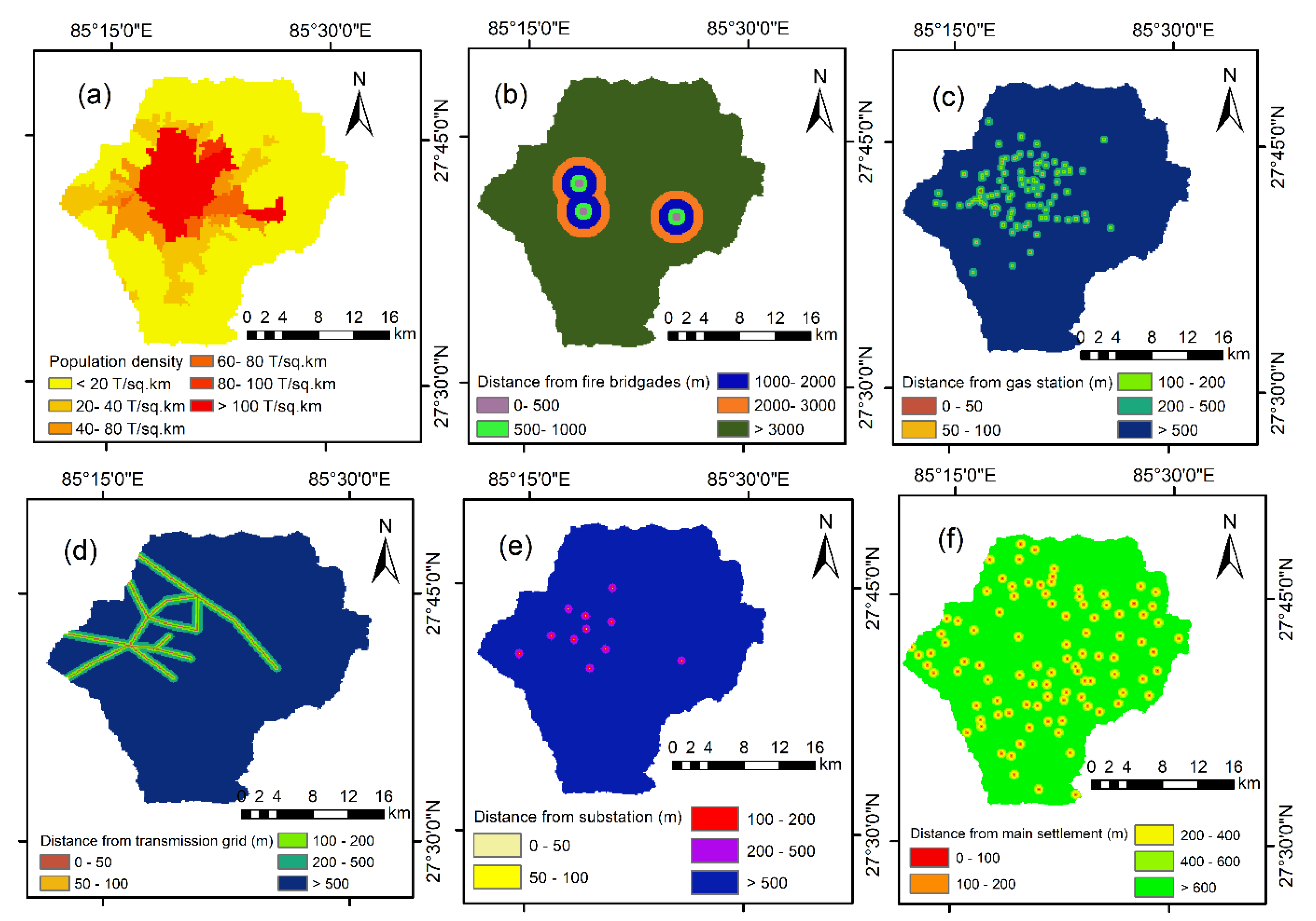
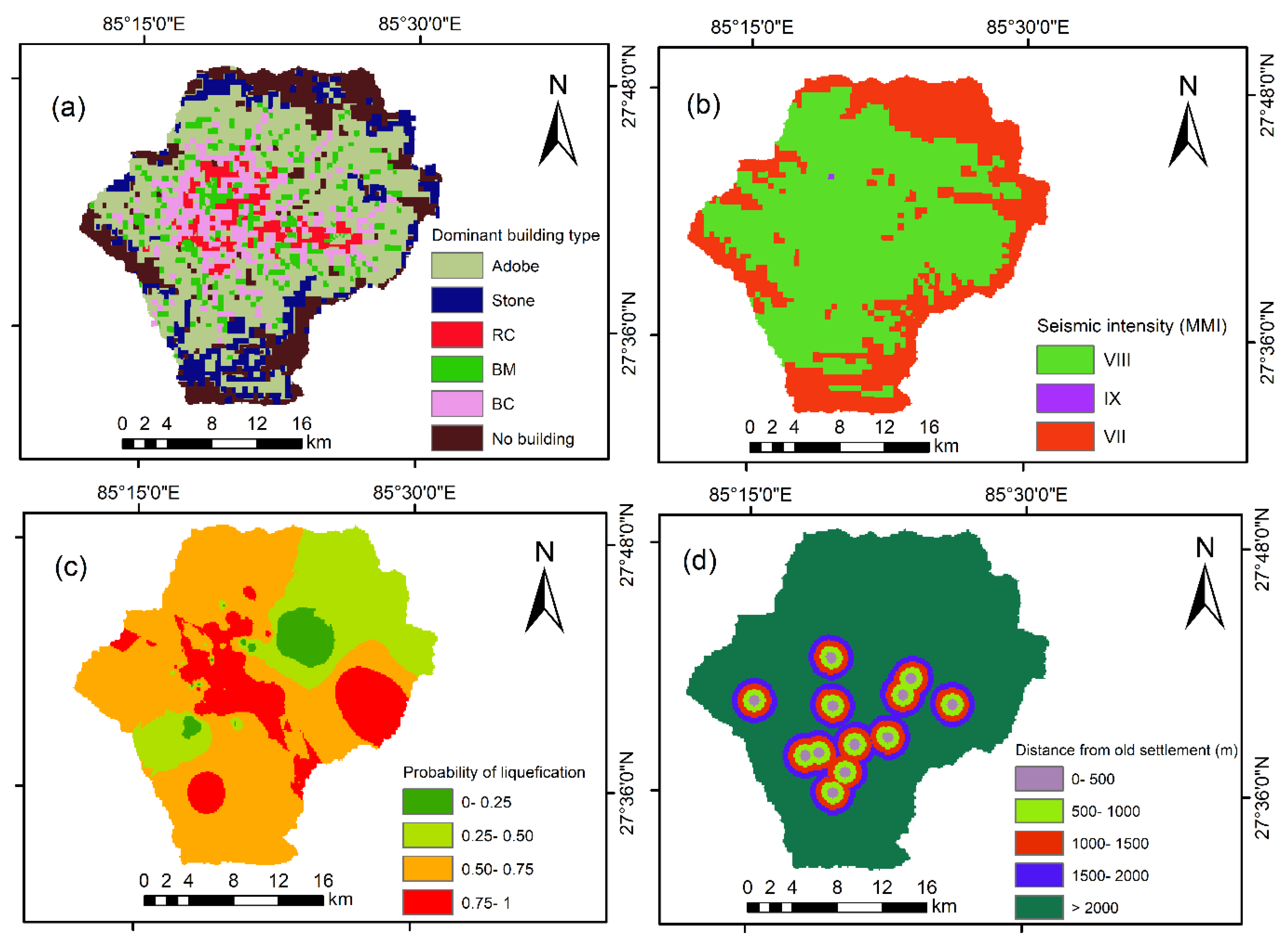
| Dataset | Data Format | Data Description/Processing | Resolution | Reference |
|---|---|---|---|---|
| Distance from fault | Line | Derived from geo-referencing | − | [50] |
| Slope | Spatial grids | Extracted from digital elevation model (DEM) | 30 m × 30 m | [51] |
| Aspect | Spatial grids | Extracted from DEM | 30 m × 30 m | [51] |
| Profile curvature | Spatial grids | Extracted from DEM | 30 m × 30 m | [51] |
| Distance from stream | Line | Extracted from DEM by arc hydro tool and buffer range of river | − | [51] |
| LULC (land use land cover) | Polygon | Land use land cover | 30 m × 30 m | [52] |
| Lithology | Polygon | Derived from geo-referencing | − | [53] |
| Distance from road | Line | Buffer of main road in Kathmandu | − | [54] |
| Annual precipitation | Excel data | Interpolation based on 21 rainfall stations in Kathmandu valley from 2000–2014 | − | [55] |
| NDVI (Normalized Difference Vegetation Index) | Spatial grids | Normalized difference vegetation index derived from Landsat8 image April 2019 | 30 m × 30 m | [51] |
| Elevation | Spatial grids | Derived from DEM | 30 m × 30 m | [51] |
| Population density | Spatial grids | Population distribution | − | [56] |
| Distance from fire brigades | Point | Buffer range of fire station | − | [54] |
| Distance from gas station | Point | Buffer range of gas station | − | [54] |
| Distance from transmission line | Line | Buffer range of transmission line | − | Nepal Electricity Authority, Nepal (https://www.nea.org.np/) |
| Distance from electric substation | Point | Buffer range of electric substation | − | Nepal Electricity Authority, Nepal (https://www.nea.org.np/) |
| Distance from main settlement | Point | Buffer range of main settlement | − | [56] |
| Distance from old settlement | Point | Buffer range of old settlement | − | [56] |
| Seismic intensity | Spatial grids | Derived from geo-referencing | − | [57] |
| Soil liquefaction | Point | Interpolation based on 88 bore holes at 1.5 m | − | [9] |
| Dominant building type | Spatial grids | Derived from geo-referencing | − | [57] |
| Dataset | Landslide Effective Factor | Flood Effective Factor | Fire Effective Factor | Earthquake Effective Factor |
|---|---|---|---|---|
| Distance from fault | √ | − | − | √ |
| Slope | √ | √ | − | √ |
| Aspect | √ | − | − | − |
| Profile curvature | √ | − | − | − |
| Distance from stream | √ | √ | − | − |
| LULC | √ | √ | √ | √ |
| Lithology | √ | √ | − | √ |
| Distance from road | √ | − | √ | − |
| Annual precipitation | √ | √ | − | − |
| NDVI | √ | − | − | − |
| Elevation | √ | √ | − | − |
| Population density | − | − | √ | √ |
| Distance from fire brigades | − | − | √ | − |
| Distance from gas station | − | − | √ | − |
| Distance from transmission line | − | − | √ | − |
| Distance from electric substation | − | − | √ | − |
| Distance from main settlement | − | − | √ | − |
| Distance from old settlement | − | − | √ | √ |
| Soil liquefaction | − | − | − | √ |
| Seismic intensity | − | − | − | √ |
| Dominant building type | − | − | − | √ |
| Hazard Zonation | Landslide (%) | Flood (%) | Fire (%) | Earthquake (%) | Multi-Hazard (%) |
|---|---|---|---|---|---|
| Very low | 14.77 | 23.65 | 33.31 | 16.06 | 20.12 |
| Low | 25.24 | 20.25 | 35.17 | 23.32 | 26.05 |
| Moderate | 28.53 | 20.97 | 15.99 | 29.13 | 22.02 |
| High | 22.68 | 21.54 | 11.88 | 22.29 | 19.24 |
| Very high | 8.78 | 13.59 | 3.66 | 9.20 | 12.57 |
| Earthquake Hazard Zone | Area | Earthquake Damage Area | Earthquake Damage Density | ||
|---|---|---|---|---|---|
| km2 | % | km2 | % | ||
| Very low | 98.44 | 16.06 | 6.03 | 5.03 | 0.061 |
| Low | 142.95 | 23.32 | 22.36 | 18.65 | 0.156 |
| Moderate | 178.54 | 29.13 | 37.68 | 31.43 | 0.211 |
| High | 136.65 | 22.29 | 34.90 | 29.11 | 0.255 |
| Very high | 56.42 | 9.20 | 18.92 | 15.78 | 0.335 |
| Hazard Zonation | Landslide | Flood | Fire | |||
|---|---|---|---|---|---|---|
| Events | % | Events | % | Events | % | |
| Very low | 1 | 2.78 | 0 | 0 | 24 | 8.76 |
| Low | 2 | 5.56 | 2 | 5.88 | 28 | 10.22 |
| Moderate | 4 | 11.11 | 2 | 5.88 | 55 | 20.07 |
| High | 13 | 36.11 | 10 | 29.41 | 80 | 29.20 |
| Very high | 16 | 44.44 | 20 | 58.82 | 87 | 31.75 |
Publisher’s Note: MDPI stays neutral with regard to jurisdictional claims in published maps and institutional affiliations. |
© 2021 by the authors. Licensee MDPI, Basel, Switzerland. This article is an open access article distributed under the terms and conditions of the Creative Commons Attribution (CC BY) license (https://creativecommons.org/licenses/by/4.0/).
Share and Cite
Khatakho, R.; Gautam, D.; Aryal, K.R.; Pandey, V.P.; Rupakhety, R.; Lamichhane, S.; Liu, Y.-C.; Abdouli, K.; Talchabhadel, R.; Thapa, B.R.; et al. Multi-Hazard Risk Assessment of Kathmandu Valley, Nepal. Sustainability 2021, 13, 5369. https://doi.org/10.3390/su13105369
Khatakho R, Gautam D, Aryal KR, Pandey VP, Rupakhety R, Lamichhane S, Liu Y-C, Abdouli K, Talchabhadel R, Thapa BR, et al. Multi-Hazard Risk Assessment of Kathmandu Valley, Nepal. Sustainability. 2021; 13(10):5369. https://doi.org/10.3390/su13105369
Chicago/Turabian StyleKhatakho, Rajesh, Dipendra Gautam, Komal Raj Aryal, Vishnu Prasad Pandey, Rajesh Rupakhety, Suraj Lamichhane, Yi-Chung Liu, Khameis Abdouli, Rocky Talchabhadel, Bhesh Raj Thapa, and et al. 2021. "Multi-Hazard Risk Assessment of Kathmandu Valley, Nepal" Sustainability 13, no. 10: 5369. https://doi.org/10.3390/su13105369
APA StyleKhatakho, R., Gautam, D., Aryal, K. R., Pandey, V. P., Rupakhety, R., Lamichhane, S., Liu, Y.-C., Abdouli, K., Talchabhadel, R., Thapa, B. R., & Adhikari, R. (2021). Multi-Hazard Risk Assessment of Kathmandu Valley, Nepal. Sustainability, 13(10), 5369. https://doi.org/10.3390/su13105369


