1. Introduction
No region, no locality in the country can be described today without noting its close dependence on or connection to every other place in the country. If that is the case, then all the regions that we once categorized as “nature” have ultimately become part of the city.
Mountain areas across the globe are undergoing land use changes driven by physical, demographic and sociocultural urbanization. Owing to abundant natural and cultural heritage, tourism development and touristification processes have become major drivers of urbanization, which not only concentrates on the built-up areas of the valley floors but reaches up to the highest peaks—a fact that presents planners and policy makers with new challenges to sustainability. While the postmodern integration of mountains into urban life already characterizes many city regions in European mountains (e.g., Grenoble, France or Innsbruck, Austria) [
2,
3], these developments are rather new and poorly understood for mountain areas in the rest of the world. The tropical mountains of western South America in general [
4], and the Peruvian Andes in particular, are a perfect case in point to better understand the past, present and future of mountain cities in the Global South, and to reflect on requirements for successfully attaining Sustainable Development Goal 11 in urbanizing mountain areas. Given the current challenges in intermediate mountain cities like Cajamarca, Cusco, Huancayo or Puno [
5,
6,
7,
8], this is a much-needed endeavor.
Adopting an idiographic and problem-oriented case study method, the present paper explores how the material and non-material dimensions of the mountain ranges in the central Peruvian Andes of Áncash have influenced the location, substance, form, structure, function and genesis of the mountain city of Huaraz over time. From a theoretical point of view, we draw on three interrelated concepts: (1) planetary urbanization; (2) touristification; and (3) verticality and vertical complementarity. These notions are put together under the umbrella of the montology approach oriented towards sustainable development [
9]. In sum, we explore how a settlement location in such a particular natural and cultural setting influences urbanization, environmental conservation and tourism development, induces processes of touristification in the city and its hinterland at different altitudinal zones and ultimately alters the materially manifested nature/culture
Gestalt of the Santa Valley or Callejón de Huaylas.
3. The Relevance of Verticality: Urbanizing Archipelagos and Touristification
Our analysis of the city–mountain interaction in Huaraz, Peru, is based on a conceptual framework that includes three main theoretical notions: that of (1) verticality and vertical complementarity [
25]; (2) planetary urbanization [
26,
27,
28]; and (3) touristification [
29]. We consider this theoretical framework helpful for exploring a set of interrelated phenomena of Huaraz Metropolitano: (1) the verticality of its settlement structures; (2) the complexity of urbanization processes that reach up to the glaciated peaks; and (3) the embeddedness in touristification processes, which influence the Santa Valley and its population.
The notion of vertical complementarity and vertical archipelagos was first developed by John Murra [
25] on the basis of Carl Troll’s
Landschaftsstufen (“landscape steps”; a term he proposes to use instead of
Landschaftsgürtel or “landscape belts”). It reflects Humboldtian thoughts on verticality [
30,
31] and refers to a model of ecological adaptation and control of different ecological levels that was widespread in the Andean region in pre-Columbian times and can even be applied today—although with different features. In the central Andes, the types of crops one can grow is mainly conditioned by the climatic and geomorphological characteristics of each zone. Given these limitations, the Andean populations have harnessed the specific characteristics of different natural regions over time, adapting to the environment and constructing systems of land use that imply vertical mobility. The vertical archipelago model foresaw, in most cases, a nucleus—as a general rule, located in the Quechua or Suni regions [
20]—from which a given ethnic group took advantage of the products of different ecological floors and “islands” located at different altitudinal levels, where they established additional peripheral settlements. This model allowed the exchange of goods and people, and led to social and ethnolinguistic relations between places more or less distant from each other (between one or two days on foot, sometimes even up to 11 days), resulting in an ecological pattern of full adaptation to the environment and to the vertical characteristics of the geographical setting. Of course, the classic model referring to the years 1460–1560 has undergone dramatic changes as a result of the sociospatial rearticulation imposed during the Iberian colonization and the early Republican phase thereafter. In any case, this model has been quite influential in the social sciences and has been discussed and applied to both historical and contemporary cases. Brush, for example, has shown three cases of contemporary geographical relations in the northern highlands of Peru, distinguishing between the “compact”, “archipelago” and “extended” types, each related to different patterns in the exploitation of ecological niches and in the form of mobility and temporary or permanent settlement [
32,
33]. Fioravanti-Molinié, in a review essay, has investigated its contemporary configuration, showing the vitality of this pattern—although, of course, greatly modified in comparison with the past [
34]. Forman, summarizing several case studies, has emphasized the importance of the vertical model for the sustainable development of the Andean region, particularly at the local and regional levels [
35]. More recently, the notion of vertical archipelagos and verticality has been applied to spatial mobility, often linked with social mobility [
36,
37,
38], as well as to the development of agriculture and sustainable rural or peri-urban areas [
39,
40]. Applications of the vertical archipelago model in the 1970s and 1980s attempted to show continuities and changes compared to the past, and particularly from the perspective of rural communities. Recent studies, such as those of Hirsch [
36] and Stadel [
39], focus instead on the interconnections between different rural and urban spaces and their interconnections with flows of goods, people, ideas, capital and symbols that connect the region with national and international spaces [
5,
41]. The latest conformation of this pattern is undoubtedly more urban than in the past and follows the development of the urban system of the central Andean countries and of processes occurring all over the planet. In the case of Huaraz Metropolitano, the notion of vertical archipelagos can be applied to a series of sites and events that occur at high altitudinal levels, interconnecting distant and “rural” places (even “wilderness”) within the “urban”, showing a local outcome of what Brenner and Schmid [
26,
28] have defined as “planetary urbanization”.
The concept of planetary urbanization was developed in response to what the authors call the “urban age” thesis [
27], a formulation that, according to them, has become a
cliché, stating that more than half of the planet’s population now lives in urban contexts. Brenner and Schmid’s critique is directed at the empirical and theoretical bases for this thesis and they point out problems such as (1) the fetishism of settlements, that is, the idea that there is a series of urban categories that can be replicated everywhere; (2) the supposed dichotomy or continuum between “urban” and “rural” worlds; (3) the model of population (re-)distribution (or mobility transition [
42]), according to which, in the course of time, people move from rural to urban areas (and
vice versa), depending on contextual variations. To these criticisms, Brenner and Schmid offer some possible strategies to overcome this impasse. First, abandoning the notion of an urban population threshold (UPT), while continuing to investigate the construction of more appropriate and meaningful world population statistics. Second, the use of geospatial data for the delineation of urban settlements, using the vast array of geographical tools available. Third, the need to abandon existing theoretical categories to explore new conceptualizations that map the current conformation of the urban [
27]. Brenner and Schmid’s research on planetary urbanization is an attempt to construct an alternative epistemology to analyze the phenomenon of urbanization. It should be noted that the term “planetary urbanization” does not refer to the assumption that the whole world is urbanizing in the same way [
28]. Rather, the authors refer to a set of issues that have to do with an uneven capitalist spatial development; the main issues are related to the need to get out of the idea of the “medieval” enclosed and finite city. The urban is not only a structural unit but also a process of sociospatial transformations mediated by capitalist forms of industrialization [
28]. In fact, for the authors, urbanization processes are multiple and different in each place, so there is no single morphology of the urban. This relates to the Lefebvrian idea that the urban/rural dichotomy has been overcome, considering that “outside” there is nothing that is not urban. It is in this sense that the authors argue that not everyone or everything is becoming urban nor going through the same processes everywhere, but that a process of urbanization with its own characteristics is underway in different parts of the world. Here, the distinction between “concentrated urbanization” and “extended urbanization” is of importance [
28]. According to Brenner and Schmid, we should speak of a dialectic rather than of a dichotomy between concentrated urbanization (aggregation and concentration) and extended urbanization [
43], the transformation of contexts and environments as supports for agglomeration. In other words, instead of relying exclusively on old classifications of places as “urban”, “nonurban” or “rural”, it is necessary to think about processual connections. In this sense, they refer to extraction zones that become part of the urbanized area, which, in this way, is not only the city, but the whole broader sociomaterial context of connections between different places that provide goods to the concentrated area. This vision goes beyond the traditional consideration of the big city or the region, thanks to infrastructures and the flow of goods—for instance, on the oceans, railways, roads or cable cars. In this way, places such as high mountains, rainforests or deserts, historically considered non-urban or “outside” the connection networks, also become urbanized. To summarize, Brenner and Schmid understand planetary urbanization as the processes of (1) intensification of land use; (2) intensification of infrastructural connection; and (3) socioenvironmental transformations; all these being mediated by a dialectic between concentrated and extended urbanization [
26,
27,
28]. In the case of Huaraz Metropolitano, this model is reflected in the connections between the zones characterized by a concentrated urbanization and those influenced by an extended one, including the surrounding different altitudinal zones of the Cordillera Blanca and Cordillera Negra, which both serve as spaces and places for the extraction of ores and for sports and/or religious events. Through the economic importance and the social and material weight of recreation and tourism, the mountains of Huaraz have become an urban asset that is rapidly changing the face of the city.
The impacts of urbanization and tourism on mountains are manifold, including what has been termed “tourist gentrification” or “Alpine gentrification” [
44]; concepts that have developed around debates on postmodern (non-dualistic and anti-hierarchical) forms of tourism. In its original sense, “gentrification” refers to the substitution of one social class by a group of supposedly higher social status in a certain area, including related “upgrades” of the built environment [
45]. While tourism doubtlessly plays an important role in the gentrification and urban reconfiguration of mountain areas, we should consider some important arguments by Sequera and Nofre [
29], who claim that applying the gentrification concept to tourism cities is not always appropriate. Instead, the authors propose to focus on the concept of “touristification” (that is, the structural and functional (re-)production of society, economy and/or environment for the sole purpose of tourism), which goes beyond the “speculation–expulsion” and “gentrification–displacement” model to account for changes driven by “large transnational forces” in the urbanization of tourism [
29,
46]. In the case of Huaraz Metropolitano, we argue, it is better to speak of touristification, a process that (1) affects diverse social classes of the resident population, (2) includes non-residents (i.e., tourists) of different social strata, and (3) leads to what has been defined as “disneyfication”, the transformation of the environment into a kind of postmodern recreational park [
47]. This often goes hand in hand with a decrease in population driven by the conversion of residential buildings into structures for tourist services. Moreover, the touristification of cities and their “operational landscapes” often triggers conflicts about the commodification of space and place (e.g., through heritagization processes). Examples include rising prices for building plots driven by the construction of tourist accommodations, such as hotels or second homes, and other tourism-related infrastructure. For the present case, the concept by Sequera and Nofre [
29] has to be adapted by two important notions: first, more than other tourist cities, mountain cities depending on tourism, like Huaraz Metropolitano, present close rural–urban interaction, for their attractiveness as destinations often rests on impressive mountain landscapes and “rural” cultures outside the core city, rather than on purely “urban” centers; hence, the notion of verticality is crucial. Second, in the course of postmodernity, a planetary urbanization process is currently underway everywhere, even on the highest glaciated peaks of the Cordillera Blanca. The study of urban touristification processes should thus not be limited to inner cities, but include even more remote sites functionally meshed with the urban center. This becomes clear when the development of a mountain city like Huaraz is tracked along both (1) space
and time and (2) nature
and culture.
6. Conclusions
The initially quoted observation by Meili [
1], who rightly interprets Swiss mountains as parts of cities, can also be made in selected mountain regions of the Global South, for instance, in Huaraz, the “Peruvian Switzerland”. With its special geographic location in the middle of the fertile Santa Valley, nestled between the Cordillera Negra and the highest tropical glaciers on Earth, the Cordillera Blanca, and because of the extensive cultural heritage that spans from the pre-Incan period through the Inca Empire and the colonial and republican era, the mountain city of Huaraz has rightly become an important tourist destination of Peru. Its identity as an Andean metropolis, where people and mountains interact closely, makes Huaraz a unique place between (1) space
and time and (2) nature
and culture. As in other mountain cities around the world, the processes of planetary urbanization have led to the integration of the high mountains into the city of Huaraz. Together with processes of touristification, we can thus see a “new” vertical complementarity of land use that, originating in the agrarian age, finds its way through urbanization into an increasingly globalized leisure society. In the age of postmodernism, Huascarán National Park has become an “operational landscape”, even a constitutive component of the city of Huaraz.
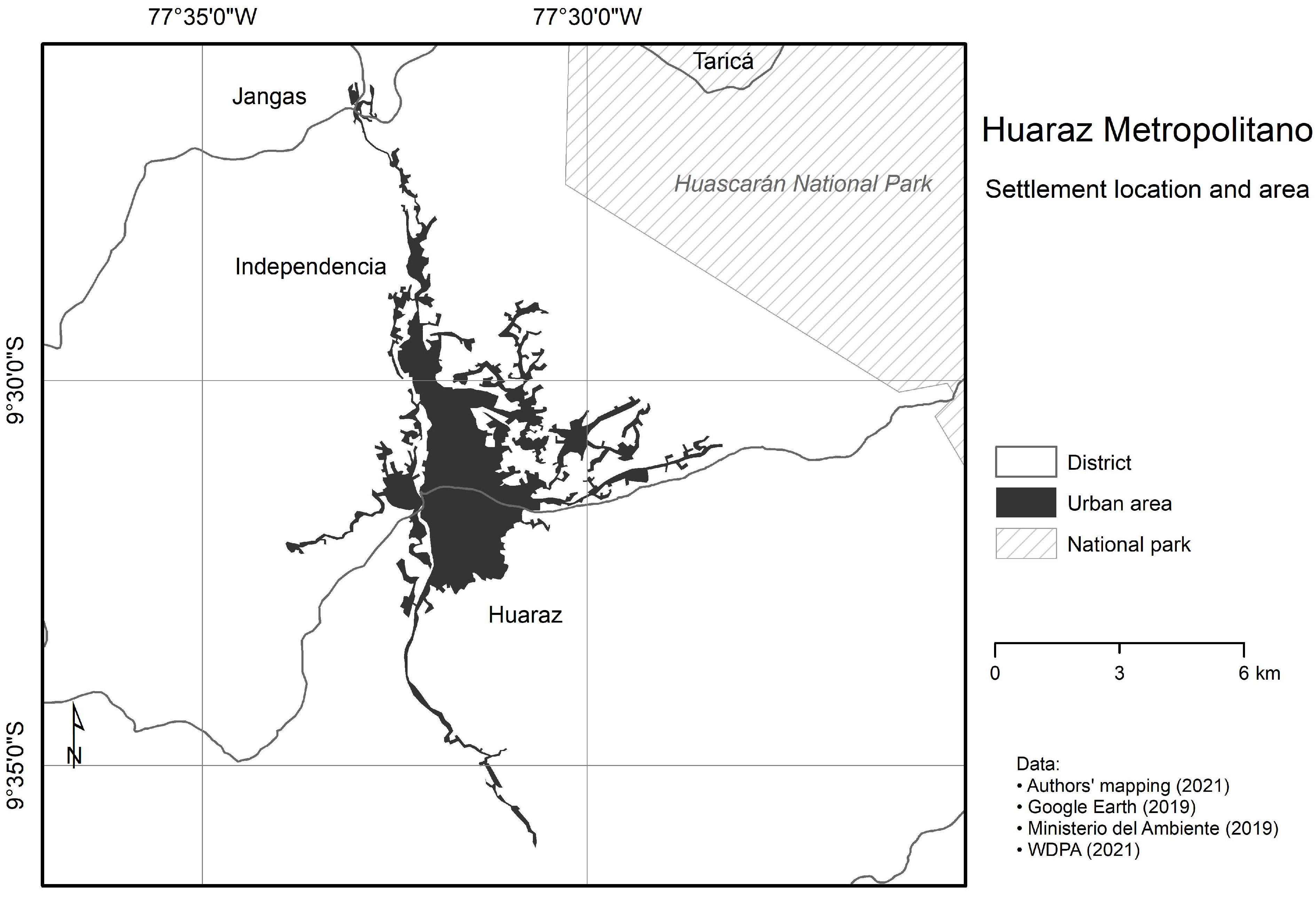
In our “modern” imagination, following old dichotomies, cities are still separated from mountains, as if a distinct boundary separated “the urban” from “the rural”. Many continue to think of studies on mountain environments as necessarily non-urban, neglecting interactions and urbanization processes that go far beyond what we commonly call a “city”. Understanding “postmodern” planetary urbanization, touristification and new forms of vertical complementarity is crucial to fostering sustainable development in the tropical Central Andes. A postmodern mode of thinking about urbanization in mountain cities like Huaraz also requires awareness of the ongoing dissolution of outdated center–periphery models, which assume that higher-up “rural” areas are dominated by the “urban” centers of the valley floors, as if the parasitic nature of cities, well-known from the feudal colonial period, continued until today. In post-suburbanization processes, the former peripheries have emancipated themselves from the once dominating city centers and now compete with the latter for investors and visitors (visible to some degree in the development of the District of Independencia, which both structurally and functionally approximates the core district of Huaraz). In the same way, a new emancipation has now set in vertically, for instance, in the Quechua, Suni, Puna and Janca zones of Huaraz Metropolitano. However, rather than competing, the vertical zones seem to complement each other both structurally and functionally. To successfully achieve Sustainable Development Goal 11 (“Sustainable Cities and Communities”) in the tropical Central Andes, it seems necessary to:
- 1.
bridge the urban–rural divide, considering mountain agriculture and campesinos (“peasants”) as integrated parts of past, present and future “urban development” and as pillars of tourism,
- 2.
beware of outdated center–periphery juxtapositions, for Huaraz Metropolitano and the Santa Valley are developing into a polycentric urban area and tourism destination and
- 3.
overcome the valley–upland dichotomy, acknowledging that Huaraz Metropolitano is turning into a postmodern, vertically organized tourist city that integrates the “operational landscape” of Huascarán National Park up to the highest peaks.
If these calls for more environmentally integrated, economically viable and socially inclusive solutions beyond common dualist thoughts were successful, the “nature” of Huaraz could lead to a new “culture” of sustainability in the Andes, from the valley floors up to the glaciated peaks.


