
Landscape Values as a Driving Force to Increase Nature Conservation. Environmental and Planning Policies as a Possible Integration


Abstract
:1. Introduction
2. Materials and Methods
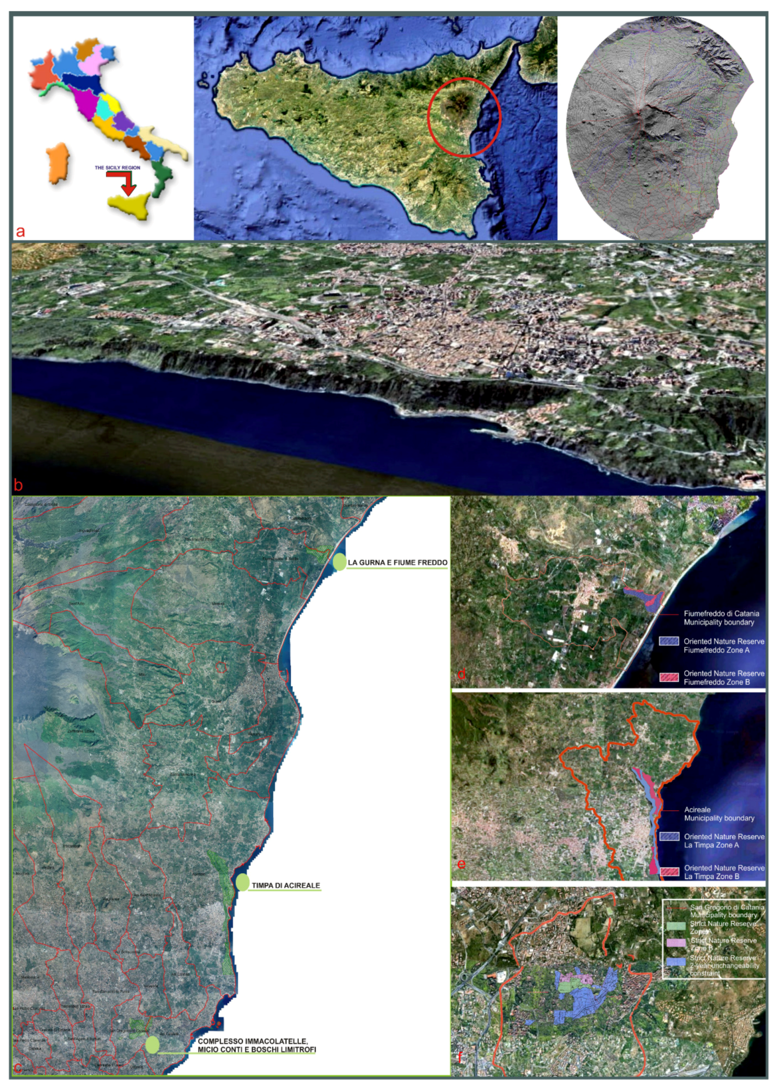
2.1. Study Area
2.2. The Methodological Approach
2.2.1. Information Collation: From Resources to Indicators
2.2.2. Final Goal
3. Results and Discussion
4. Conclusions
Supplementary Materials
Author Contributions
Funding
Institutional Review Board Statement
Informed Consent Statement
Data Availability Statement
Conflicts of Interest
References
- Council of Europe. European Landscape Convention, European Treaty Series—No. 176; Council of Europe Publishing: Strasbourg, France, 2000. [Google Scholar]
- Council of Europe. Landscape in Planning Policies and Governance, No 89; Council of Europe Publishing: Strasbourg, France, 2009. [Google Scholar]
- Council of Europe. Landscape Dimensions. Reflections and Proposals for the Implementation of the European Landscape Convention; Council of Europe Publishing: Strasbourg, France, 2017. [Google Scholar]
- Antrop, A. Landscape change and the urbanization process in Europe. Landsc. Urban Plan. 2004, 67, 9–26. [Google Scholar] [CrossRef]
- Antrop, A. Why landscapes of the past are important for the future. Landsc. Urban Plan. 2005, 70, 21–34. [Google Scholar] [CrossRef]
- Mcdonald, R.; Forman, R.T.T.; Kareiva, P.; Neugartena, R.; Salzer, D.; Fisher, J. Urban effects, distance, and protected areas in an urbanizing world. Landsc. Urban Plan. 2009, 93, 63–75. [Google Scholar] [CrossRef]
- Rodrigo de la O Cabrera, M.; Marine, N.; Escudero, D. Spatialities of cultural landscapes: Towards a unified vision of Spanish practices within the European Landscape Convention. Eur. Plan. Stud. 2020, 28, 1877–1898. [Google Scholar] [CrossRef]
- Leone, A. Ambiente e Pianificazione. Uso del Suolo e Processi di Sostenibilità; Franco Angeli Editore: Milano, Italy, 2019. (In Italian) [Google Scholar]
- Cialdea, D. The city and natural resources. Tema. J. Land Use Mobil. Environ. 2020, 14, 67–79. [Google Scholar] [CrossRef]
- Cialdea, D.; Pompei, C. The territorial framework of the river courses: A new methodology in evolving perspectives. Eur. Plan. Stud. 2020, 29, 1–20. [Google Scholar] [CrossRef]
- Dorning, M.A.; Koch, J.; Shoemaker, D.A.; Meentemeyer, R. Simulating urbanization scenarios reveals tradeoffs between conservation planning strategies. Landsc. Urban Plan. 2015, 136, 28–39. [Google Scholar] [CrossRef] [Green Version]
- La Rosa, D.; Privitera, R. Characterization of non-urbanized areas for land-use planning of agricultural and green infrastructure in urban contexts. Landsc. Urban Plan. 2013, 109, 94–106. [Google Scholar] [CrossRef]
- Arnold, J.; Kleemann, J.; Fürst, C.A. Differentiated Spatial Assessment of Urban Ecosystem Services Based on Land Use Data in Halle, Germany. Land 2018, 7, 101. [Google Scholar] [CrossRef]
- Shaw, B.J.; van Vliet, J.; Verburg, P.H. The peri-urbanization of Europe: A systematic review of a multifaceted process. Landsc. Urban Plan. 2020, 196, 103733. [Google Scholar] [CrossRef]
- Honeck, E.; Moilanen, A.; Guinaudeau, B.; Wyler, N.; Schlaepfer, M.A.; Martin, P.; Sanguet, A.; Urbina, L.; von Arx, B.; Massy, J.; et al. Implementing Green Infrastructure for the Spatial Planning of Peri-Urban Areas in Geneva, Switzerland. Sustainability 2020, 12, 1387. [Google Scholar] [CrossRef] [Green Version]
- European Environmental Agency (EEA). Urban Sprawl in Europe. The Ignored Challenge, Report No 10/2006; European Environmental Agency (EEA): Copenhagen, Denmark, 2006. [Google Scholar]
- European Environmental Agency (EEA). Urban Sprawl in Europe, Report No 11/2016; European Environmental Agency: Copenhagen, Denmark, 2016. [Google Scholar]
- Nadin, V.; Stead, D. European spatial planning systems, social models and learning. Plan. Rev. 2008, 44, 35–47. [Google Scholar] [CrossRef]
- Vizzari, M.; Sigura, M. Landscape sequences along the urban–rural–natural gradient. Landsc. Urban Plan. 2015, 140, 42–55. [Google Scholar] [CrossRef]
- Zasada, I.; Häfner, K.; Schaller, L.; van Zanten, B.T.; Lefebvre, M.; Malak-Rawlikowska, A.; Nikolov, D.; Rodríguez-Entrena, M.; Manrique, R.; Ungaro, F.; et al. A conceptual model to integrate the regional context in landscape policy, management and contribution to rural development: Literature review and European case study evidence. Geoforum 2017, 82, 1–12. [Google Scholar] [CrossRef]
- Cialdea, D. Landscape Features of Coastal Waterfronts: Historical Aspects and Planning Issues. Sustainability 2020, 12, 2378. [Google Scholar] [CrossRef] [Green Version]
- UNESCO. Intangible Cultural Heritage List. 2020. Available online: https://ich.unesco.org/en/lists (accessed on 9 October 2020).
- UNESCO World Heritage Centre. World Heritage Agricultural Landscapes. World Heritage. 2013, p. 69. Available online: https://ich.unesco.org (accessed on 9 October 2020).
- UNESCO World Heritage Centre. Cultural Landscapes. 2020. Available online: https://whc.unesco.org/ (accessed on 9 October 2020).
- Dorren, L.; Rey, F. A Review of the Effect of Terracing on Erosion; Scape, Soil Conservation and Protection for Europe, 2004; pp. 97–108. Available online: http://ecorisq.org/docs/ (accessed on 3 March 2021).
- Grove, A.T.; Rackham, O. The Nature of Mediterranean Europe, an Ecological History; Yale University Press: New Haven, CT, USA, 2003. [Google Scholar]
- Arnàez, J.; Lana-Renault, N.; Lasanta, T.; Ruiz-Flano, P.; Castroviejo, J. Effects of farming terraces on hydrological and geomorphological processes. A review. Catena 2015, 128, 122–134. [Google Scholar] [CrossRef] [Green Version]
- Tarolli, P.; Preti, F.; Romano, N. Terraced landscapes. Anthropocene 2014, 6, 10–25. [Google Scholar] [CrossRef]
- Cammeraat, L.H. Scale dependent thresholds in hydrological and erosion response of a semi-arid catchment in southeast Spain. Agric. Ecosyst. Environ. 2004, 104, 317–332. [Google Scholar] [CrossRef]
- Perlotto, C.; D’Agostino, V. Performance assessment of bench-terraces through 2-D modelling: Performance assessment of bench-terraces. Land Degrad. Dev. 2016, 29. [Google Scholar] [CrossRef]
- Agnoletti, M.; Errico, A.; Santoro, A.; Dani, A.; Preti, F. Terraced landscapes and hydrogeological risk. effects of land abandonment in Cinque Terre (Italy) during Severe Rainfall Events. Sustainability 2019, 11, 235. [Google Scholar] [CrossRef] [Green Version]
- Barbera, G.; Cullotta, S.; Rossi-Doria, I.; Rühl, J.; Rossi-Doria, B. I Paesaggi a Terrazze in Sicilia; ARPA: Palermo, Italy, 2010. [Google Scholar]
- Barbera, G.; Biasi, R.; Marino, D. I Paesaggi Agrari Tradizionali; Palmieri, M., Ed.; FrancoAngeli: Milano, Italy, 2014. [Google Scholar]
- Privitera, S. Geomorphological characters of the Etna coast (eastern Sicily): Examples of irreversible environmental degradation due to anthropic activities. Geologie 2010, 160, 173–177. [Google Scholar]
- Privitera, S. Il territorio del Monte Etna da Parco Regionale a Patrimonio Naturale Mondiale dell’UNESCO. Geotema 2018, 57, 143–148. (In Italian) [Google Scholar]
- Regione Siciliana. Regional Decree 14 March 1984, no. 84 Costituzione della riserva naturale «La Timpa», ricadente nel comune di Acireale. Available online: http://www.regione.sicilia.it/agricolturaeforeste/ (accessed on 9 October 2020).
- Regione Siciliana. Regional Decree 23 Avril 1999 Istituzione della riserva naturale orientata La Timpa, ricadente nel territorio del comune di Acireale, 1999. Available online: http://www.regione.sicilia.it/agricolturaeforeste/ (accessed on 9 October 2020).
- Melzer, R.; Ezzy, L.; Hines, H.B. Health checks: A simple tool for assessing the condition of values and effectiveness of reserve management. Parks 2019. [Google Scholar] [CrossRef]
- Dolomiti Unesco Rete delle Aree Protette. La Rete Delle Aree Protette Dolomiti Unesco, 2014. Available online: https://www.dolomitiunesco.info/ (accessed on 9 January 2020).
- Cialdea, D. Planning activities in coastal areas italian and cross-border approaches along the adriatic sea. Int. J. Sustain. Dev. Plan. 2017, 12, 853–866. [Google Scholar] [CrossRef]
- Cialdea, D. Smart land: Regeneration and sustainability in lost scenarios and new performances. In Smart Planning: Sustainability and Mobility in the Age of Change; Rocco, P., Fistola, R., Gargiulo, C., Eds.; Springer International: Cham, Switzerland, 2018; pp. 1–25. [Google Scholar] [CrossRef]
- Cialdea, D. Spatial evolutions between identity values and settlements changes. Territorial analyses oriented to landscape regeneration. In Planning, Nature and Ecosystem Services; Gargiulo, C., Zoppi, C., Eds.; Fedoapress: Napoli, Italy, 2019; pp. 10–19. [Google Scholar] [CrossRef]
- Peano, A.; Cassatella, C. (Eds.) Landscape Indicators. Assessing and Monitoring Landscape Quality; Springer: Dordrecht, NL, USA, 2011. [Google Scholar]
- Cialdea, D. (Ed.) Environmental Assessment Interreg Report 3 GES.S.TER./Interreg IIIA; Arti Grafiche La Regione: Campobasso, Italy, 2007. [Google Scholar]
- Regione Molise. Agreement with the University of Molise—l.a.co.s.t.a. Laboratory (Director Prof. D. Cialdea) for Preliminary Researches for the “New Regional Landscape Plan of Molise”. Available online: http://www3.regione.molise.it/flex/cm/pages/ServeBLOB.php/L/IT/IDPagina/1 (accessed on 11 February 2011).
- Regione Molise. Agreement with the University of Molise—l.a.co.s.t.a. Laboratory BURM No. 47 (16.11.2019). Available online: http://cloud.urbi.it/urbi/progs/urp/ur2DE001.sto?StwEvent=101&DB_NAME=l1200158&IdDelibere=75417 (accessed on 10 April 2021).
- Privitera, D.; Privitera, S. Laboratory as experiment in field learning: An application in a touristic city. J. Res. Didact. Geogr. 2018, 1, 77–88. [Google Scholar] [CrossRef]
- Simeonova, V.; van der Valk, A. Environmental policy integration. Land Use Policy 2016, 57, 80–93. [Google Scholar] [CrossRef]
- Ledda, A.; Anna Di Cesare, E.; Satta, G.; Calia, G.; Arras, F.; Congiu, A.; Manca, E.; De Montis, A. Adaptation to Climate Change and Regional Planning: A Scrutiny of Sectoral Instruments. Sustainability 2020, 12, 3804. [Google Scholar] [CrossRef]
- Tewdwr-Jones, M.; Bishop, K.; Wilkinson, D. Euroscepticism. Political Agendas and Spatial Planning: British National and Regional Planning Policy in Uncertain Times. Eur. Plan. Stud. 2000, 8, 651–668. [Google Scholar] [CrossRef]
- Getimis, P. Comparing spatial planning systems and planning cultures in Europe. Plan. Pract. Res. 2012, 27, 25–40. [Google Scholar] [CrossRef]
- Liberato, D.; Alén, E.; Liberato, P.; Domínguez, T. Governance and cooperation in Euroregions: Border tourism between Spain and Portugal. Eur. Plan. Stud. 2018. [Google Scholar] [CrossRef]
- Amdam, J. Structure and strategy for regional learning and innovation. Eur. Plan. Stud. 2003, 11, 439–459. [Google Scholar] [CrossRef]
- Rudolf, S.C.; Grădinaru, S.R.; Hersperger, A.M. Impact of planning mandates on local plans. Eur. Plan. Stud. 2017, 25, 2192–2211. [Google Scholar] [CrossRef]
- Brunetta, G.; Voghera, A. Evaluating landscape for shared values: Tools, principles, and methods. Landsc. Res. 2008, 33, 71–87. [Google Scholar] [CrossRef]
- De Montis, A. Impacts of the European landscape convention on national planning systems. Landsc. Urban Plan. 2014, 124, 53–65. [Google Scholar] [CrossRef]
- De Montis, A. Measuring the performance of planning: The conformance of Italian landscape planning practices with the European Landscape Convention. Eur. Plan. Stud. 2016, 24, 1727–1745. [Google Scholar] [CrossRef]
- Finn, D.; Hopkins, L.D.; Wempe, M. The information system of plans approach: Using and making plans for landscape protection. Landsc. Urban Plan. 2007, 81, 132–145. [Google Scholar] [CrossRef]
- Gambino, R.; Peano, A. (Eds.) Nature Policies and Landscape Policies. Towards an Alliance; Springer: Cham, Switzerland, 2015. [Google Scholar] [CrossRef]
- Wissen Hayek, U.; von Wirth, T.; Neuenschwander, N.; Grêt-Regamey, A. Organizing and facilitating Geodesign processes. Landsc. Urban Plan. 2016, 156, 59–70. [Google Scholar] [CrossRef] [Green Version]


| 1. PHYSICAL–ENVIRONMENTAL SYSTEM | Indicators are related to the presence and the features of SCI/SPAs, nature reserves, parks and additional interests. |
| 2. LANDSCAPE–VISUAL SYSTEM | Indicators are related to the existing landscape restriction, residual areas (as “rasule”, “saje”), forests and additional interests. |
| 3. HISTORICAL–CULTURAL SYSTEM | Indicators are related to archaeological restriction, architectural restriction, urban planning intervention and additional interests. |
| 4. AGRICULTURE–PRODUCTIVE SYSTEM | Indicators are related to land use for agricultural activities, land use for agricultural agri-food, land use for organic activities and additional interests. |
| 1. PHYSICAL–ENVIRONMENTAL SYSTEM | Detractors are related to the presence and the features of land restriction such as seismic, hydro-geological and restriction by L. 445/1908 and additional trouble. |
| 2. LANDSCAPE–VISUAL SYSTEM | Detractors are related to the existing wind-power and ground-mounted photovoltaic plants, quarries, suburban sprawl and additional trouble. |
| 3. HISTORICAL–CULTURAL SYSTEM | Detractors are related to investigation about preservation conditions, private property, access conditions and additional trouble. |
| 4. AGRICULTURE–PRODUCTIVE SYSTEM | Detractors are related to the presence of industrial sites, special districts, other and additional trouble. |
| 1. OML | Over-Municipal Level |
| 2. ML | Municipal Level |
| 3. AO | Agriculture-Oriented |
| 4. TO | Tourism-Oriented |
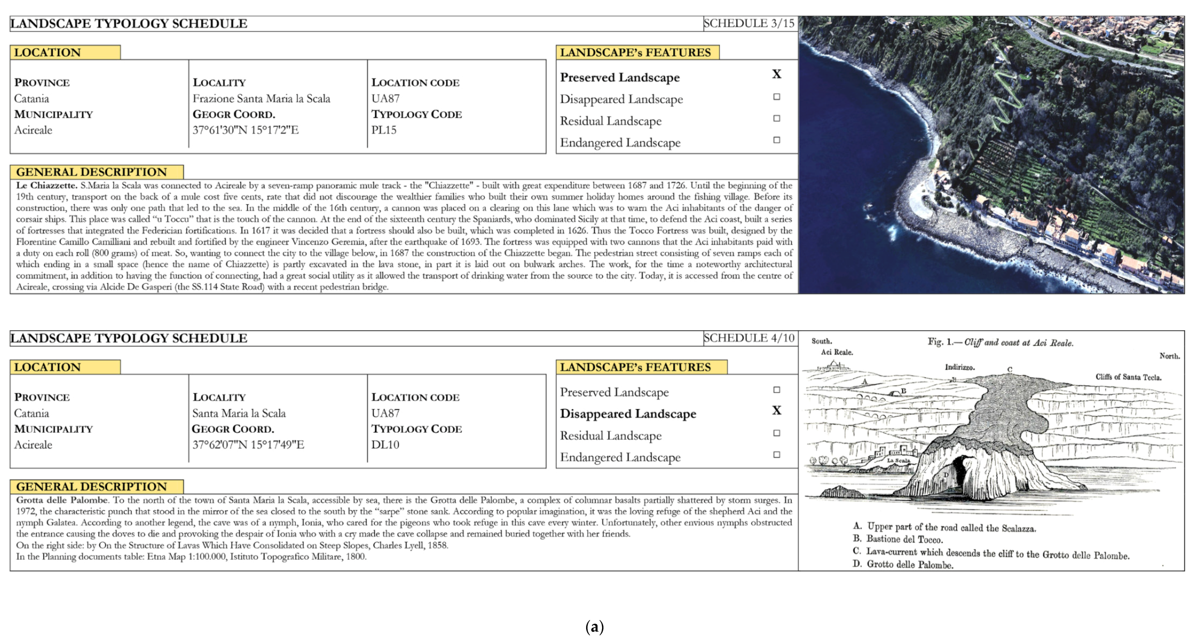
| 1. Identification and position data | This first part of the record, consisting in the geographical data relating to the position of the examined area, is the main phase of the census. Information includes the province, the municipality and the geographical position (in the WGS84 reference system) with an indication of whether it falls in urban, suburban, mixed or primarily agriculture voted. |
| 2. Lytho-morphology features | Lytho-morphology features with the main dangerousness, and other features related to territorial and environmental systems. |
| 3. Description, map and photos | The central part of the schedule contains data related to the specific analysed element, with the brief description, the indication of the area peculiarities, the referenced cartography and photos. |
| 4. Rules and norms | The last part contains the main current planning tools in the area under study. |
| Category | Plan | Year | Main Aim | Reference |
|---|---|---|---|---|
| OML | Landscape Regional Plan The Landscape Plan for Areas 8, 11, 12, 13, 14, 16, 17 in Catania Province | 2018 | The Area No. 13 Landscape Plan identifies 12 Landscape sub -areas (SP), from which the SP8 area of lemon groves of the Ionian coast has been recognized. Acireale has a peculiar, close and specific relationship both with the sea and with the volcano. | [1] |
| OML | Catania Province Territorial Plan Province Territorial Plan. Cognitive Structural Asset, 2010 Province Territorial Plan. Proposal Strategic Asset, 2010 | 2010 | It promotes strategies and focuses the intervention priorities in the metropolitan area of the eastern side of the province of Catania, which is defined as the most complex territory from the point of view of infrastructure and interactive relationships with the capital, Catania. Furthermore, Acireale is the most important centre, rich in cultural and landscape–environmental heritage. | [2,3] |
| OML | Nature Reserve Zones “Timpa di Acireale” Oriented Nature Reserve | 1999 | In the whole territory of the protected area, scientific research activities can be carried out by qualified subjects authorized by the managing body which alone can grant exceptions to the prohibitions and norms. | [4] |
| OML | ITA070004 SAC Management Plan SCI COD. ITA 070,004 “Timpa di Acireale” Management Plan POR 1999.IT.16.1.PO.011/1.11/11.2.9/0345 | 2009 | The SAC (special area of conservation) ITA070004, named “Timpa di Acireale”, is one of the numerous ReteNatura2000 sites of community importance in Sicily. Its management plan in force was drawn up in 2009 and finally approved in 2010. | [5] |
| OML | Hydro-geological Management Plan HMP. Territorial area between Simeto and Alcantara Rivers, 2006 Update HMP for the Acireale Municipality, 2017 Update HMP for the Hydraulic Hazard due to flooding phenomena. Territorial area between Simeto and Alcantara Rivers, 2018 | 2018 | It has the value as a sector territorial plan and is the cognitive, regulatory and technical–operational tool through which interventions and actions are planned and rules of use are programmed concerning the defence against the hydrogeological risk of the Sicilian territory. The landslides that periodically occurr at Timpa of Acireale are directly correlated with meteorological events of particular intensity occurring in the Mediterranean Basin during the winter. | [6,7,8] |
| OML | Province Waste Management Plan Strategic Environmental Assessment. The Città Metropolitana di Catania Waste Province Plan Revision | 2016 | It has been established by the Metropolitan City of Catania, in compliance with the precautionary principle which is an informative principle of EU and international legislation and which “requires the implementation of actions without delay of contrast in cases where there is a threat of “serious or irreversible” damage to the environment”, (Art. 174 of the Amsterdam Treaty, which incorporates Art. 130 of the Treaty of Maastricht). | [9] |
| ML | Acireale Municipality Master Plan Approval of the Acireale Municipality Master Plan Decree 18 January 2005 updating the Decree 4 November 2003 | 2005 | It contains the general prescriptions for settlement densities of different territorial areas. The plan pays attention to the territory of the Timpa Reserve, for which it refers to the norms of the reserve itself (any activity must be previously authorized by the management authority) | [10] |
| ML | Acireale Strategic Plan for the Landscape Landscape Plan of the Acireale Municipality | 2006 | Adhering to what is defined by the Strategic Cities Network 2014–2020 EU Programme activated this governance process in order to mobilize investors: the main aim was to make Acireale an example for southern Europe, due to its magnificent territorial potential. | [11] |
| ML | Acireale Municipality Civil Protection Plan (Update 2013) | 2013 | It plans all coordinated activities and civil protection procedures to face and overcome a calamitous event expected in the area. The method actually involves a real preventive planning of the event, and the same is based on principles of simplicity, flexibility and efficiency. | [12] |
| ML | Acireale Municipality Drawing up for the Coastal Public Property Areas Management Plan 2020 adopted | not yet approved. | This document is a planning tool which identifies how to use the seacoast and regulates its utilization; therefore it has important economic repercussions on the development of the territory, public health and safeguarding environment. | [13] |
| AO | “Le Terre di Aci” Local Development Participation Strategy 2014/2020 Rural Development Programme | 2016 | This document provides an analysis of the development and potential needs of the “Terre di Aci” area and identifies a development strategy. It includes 5 municipalities (Acireale Aci Sant’Antonio Acicatena Aci Bonaccorsi and Valverde). In the municipality of Acireale, citrus growing constitutes around 2500 hectares of cultivated land, followed by viticulture, entering the tourist circuit named “the Wine Roads”. | [14] |
| AO | Atlas of PDO, PGI and TSG products by Italian Agriculture Ministry Update 2018 | 2018 | List of Italian names, registered in the Register of Protected Designations of Origin (PDO), Protected Geographical Indication (PGI) and Traditional Specialties Guaranteed (TSG), EU Regulation No. 1151/2012 of the European Parliament and of the Council of 21 November 2012 (updated on 12 February 2020. | [15] |
| AO | Citrus Plan (Piano agrumi) INEA Institute | 2008 | In regard to citrus crops, in 1907, the Experimental Station of Fruit and Citrus was established in Acireale. In 1967, it was transformed into the Experimental Institute for Citrus, then in 1999 into the Agricultural Research Council and in 2007, finally, it became the Research Centre for Citrus and Mediterranean Crops. | [16] |
| AO | 2014/2020 Sicilian Rural Development Programme ALLEGATO 14 PSR SICILIA (Piano di sviluppo Rurale) 2014/2020 “I paesaggi a terrazze in Sicilia. Metodologie per l’analisi, la tutela e la valorizzazione” | 2015 | The programme aims at implementing ecological–environmental and historical–cultural landscapes, so numerous in Sicily, for a collective project that measures the need to produce with the available native resources and with the environment features, specially oriented to terraced landscapes. | [17] |
| TO | “Le Terre di Aci” Local Development Participation Strategy 2014/2020 Rural Development Programme | 2016 | The human activity of the past has produced a terraced landscape, with stairs, walls and small stone buildings, which has evolved over time, passing from the nineteenth-century vine plant to the subsequent citrus plant, especially in lemons. | [18] |
| TO | “Tourism Economies” Urban Redevelopment and Sustainable Land Programme Programma di Riqualificazione Urbana e Sviluppo Sostenibile del Territorio, | 2007 | It seems to disregard principles indicated in the Catania municipality programme: the traditional view of bringing the tourist incentive back to the receptive structures construction prevails, often in conflict with environmental sustainability criteria. | [19] |
| TO | Territorial Tourist District of the Sicilian Region “Il Mare dell’Etna” ERDF (European Regional Development Fund) OP (Operative Programme) | 2007–2013 | The district highlights the presence of two important attractors: the sea and Mount Etna, as recently declared Heritage of Humanity by UNESCO. | [20] |
| TO | ACIGREENWAY Cycle-pedestrian path on the old route of the disused railway in the Acireale Municipality within the Greenways Project (taken from the plan for non-motorized mobility in Sicily) | 2017 | The main aim is the recovery of the old railway line dating back to the end of the 19th century. It was in 1864 when the council of the municipality of Acireale was gathered in several sessions to deliberate the construction of the railway station. In 1866, the first train arrived. | [21] |
| TO | Heaven and Earth Ecomuseum initiative of the Acireale Diocese | 2017 | The open-air ecomuseum aims at promoting the huge artistic heritage, as well as the tourism economy. | [22] |
| TO | Archaeological and landscape Park of Catania and the “Valle dell’Aci” | 2019 | The system of archaeological parks in Sicily was provided by regional law No. 20/2000. The Archaeological and Landscape Park is a new institution that only dates back to 2019. | [23] |
| TO | Regional Tourist Propaganda Plan 2016, 2018 ERDF (European Regional Development Fund) OP (Operative Programme) | 2014–2020 | The plan describes the strategic and political guidelines for the development of Sicily, and aims at implementing a strategy for promoting the Sicily brand. | [24] |
| TO | #Turismosicilia2020 Three-year Tourism Development Programme 2015–2017 of the Sicilian Region Strategic Plan | 2014–2020 | The procedures for the concession for tourism activities involve 5 different figures (Port Authorities, Cultural Heritage Ministry, Municipality, Regional Department, Civil Engineering Department). It is necessary to simplify the authorization regimes. | [25] |
| TO | FOCUS Tourism Productive District “Agrumi di Sicilia—Le Vie della Zagara” Protection and Enhancement of Italian Geographical Indications Consortium | 2018 | District citrus fruits of Sicily wants to encourage the growth of a proposed tourist and territorial quality. For a few years, in fact, thanks to the agreement with the Association Taste, organic productions have been involved. | [26] |
| TO | Catania Province Territorial Plan Province Territorial Plan. Cognitive Structural Asset, 2010 Province Territorial Plan. Strategic Asset Proposal, 2010 | 2010 | It underlines environmental, cultural and historical values. | [2,3] |
| TO | UNESCO Sites Mount Etna (Italy) Art of dry-stone walls Submitted Application for the historical centre of Acireale | 2013 2018 in fieri | Mount Etna was recognized as a World Heritage Site for its fundamental role within the Mediterranean. Moreover, drywall structures are used as shelters, for agriculture or cattle breeding, and testify to the methods used, from prehistory to the present day, to organize life and workspaces by optimizing local human and natural resources. | [27,28,29] |
| RS | ELEMENTS | RATE | DESCRIPTION |
|---|---|---|---|
| PHYSICAL–ENVIRONMENTAL SYSTEM | VALUES | ||
| SCI/SPAs | 2 | The value of each protected area was calculated according to the protection level—that is, from 0 = none; 1 = local l.; 2 = natura2000 network l.; 3 = regional l.; 4 = national l.—and to the percentage of the protected area in relation to the whole area. The added value in this case is related to the proximity to the S. Maria La Scala, Don Masi Timpa and Gazzena geosites. | |
| Nature Reserve | 3 | ||
| Park | 0 | ||
| Additional Interest | 2 | ||
| DETRACTORS | |||
| Seismic Restriction | 4 | Detractors in this system are related to problems expressed by constraints linked to the soil features. Their evaluation was made according to the percentage of surface in relation to the whole area—that is, from 0 = none; 1 = 0–25; 2 = 25–50; 3 = 50–75; 4 = 75–100%. A further problem is given by the data of the R4 and P4 surfaces, as mentioned in the recent updated hydrogeological plans. | |
| Hydro-Geological Restriction | 4 | ||
| L. 445/1908 Restriction | 1 | ||
| Additional Trouble | 3 | ||
| UPCOMING PROJECTS | |||
| Consolidation | 2 | The value of each element was calculated according to the implementation level of the projects, as deduced from the urban planning and planning tools of Table 5—that is, from 0 = none; 1 = 0–25; 2 = 25–50; 3 = 50–75; 4 = 75–100% than expected. The additional value in this case relates to any operations to combat run-off waters due to meteoric events. | |
| Solution to prevent fire | 1 | ||
| Solution to prevent people’s danger | 1 | ||
| Additional Intervention | 0 | ||
| LANDSCAPE–VISUAL SYSTEM | VALUES | ||
| Landscape Restriction | 4 | The value of each element was calculated according to the constrained surface as a percentage of the whole area—that is, from 0 = none; 1 = 0–25; 2 = 25–50; 3 = 50–75; 4 = 75–100%. The added value in this case is related to the panoramic view of historical paths. | |
| Residuals (rasule, saje) | 3 | ||
| Forests | 3 | ||
| Additional Interest | 4 | ||
| DETRACTORS | |||
| Wind-Power and Ground-Mounted Photovoltaic Plants | 0 | Detractors in this system are referred to the impediments to the landscape perception. Their evaluation was made as a function related to the percentage of surface compared to the whole area—that is, from 0 = none; 1 = 0–25; 2 = 25–50; 3 = 50–75; 4 = 75–100%. A further problem is given by the interventions carried out along the coast with widespread overbuilding. | |
| Quarries | 0 | ||
| Suburban sprawl | 2 | ||
| Additional Trouble | 4 | ||
| UPCOMING PROJECTS | |||
| Dry-stone walls restoration | 1 | The value of each element was calculated according to the implementation level of the projects, as deduced from the urban planning and planning tools of Table 5—that is, from 0 = none; 1 = 0–25; 2 = 25–50; 3 = 50–75; 4 = 75–100% than expected. The additional value in this case relates to territorial services of peri-urban green spaces. | |
| Solution to prevent settlement expansion | 4 | ||
| Solution for people fruition | 3 | ||
| Additional Intervention | 1 | ||
| HISTORICAL–CULTURAL SYSTEM | VALUES | ||
| Archaeological Restriction | 2 | The value of each element was calculated based on the number of the restricted “common goods”—that is, from 0 = none; 1 = 0–5; 2 = 5–10; 3 = 10–20; 4 ≥20. The UNESCO proposal for the historic centre is relevant. The added value in this case is related to the enhancement of the Testa dell’Acqua watermill and the Miuccio spring complex. | |
| Architectural Restriction | 4 | ||
| Urban Planning Intervention | 1 | ||
| Additional Interest | 4 | ||
| DETRACTORS | |||
| Preservation Condition | 4 | Detractors of this system are related to the impediments to the use of cultural heritage. A quantitative assessment of the conditions detected in situ was carried out—that is, from 0 = none; 1 = 0–25; 2 = 25–50; 3 = 50–75; 4 = 75–100% of the whole area. A further problem is the possible lack of knowledge even by local citizens. | |
| Private Property | 3 | ||
| Access Condition | 0 | ||
| Additional Trouble | 0 | ||
| UPCOMING PROJECTS | |||
| Historical Heritage Restoration | 4 | The value of each element was calculated according to the implementation level of the projects, as deduced from the urban planning and planning tools of Table 5—that is, from 0 = none; 1 = 0–25; 2 = 25–50; 3 = 50–75; 4 = 75–100% than expected. The additional value is related to the creation of the “Catania Archaeological and Landscape” and the “Valle delle Aci” Parks. | |
| Solution to prevent settlement abandonment | 0 | ||
| Solution for public fruition | 4 | ||
| Additional Intervention | 3 | ||
| AGRICULTURE-PRODUCTIVE SYSTEM | VALUES | ||
| Land Use for Agricultural Activities | 4 | The value of each of the elements was calculated based on the percentage of land use surfaces related to the whole area—that is, from 0 = none; 1 = 0–25; 2 = 25–50; 3 = 50–75; 4 = 75–100%. The added value in this case is related to the presence of the Mediterranean maquis. | |
| Land Use for Agricultural Agri-food | 1 | ||
| Land Use for Organic activities | 0 | ||
| Additional Interest | 1 | ||
| DETRACTORS | |||
| Industrial Sites | 0 | Detractors of this system are related to the impediments to the carrying out of agricultural activities. A quantitative assessment of the conditions detected in situ was carried out—that is, from 0 = none; 1 = 0–25; 2 = 25–50; 3 = 50–75; 4 = 75–100 of the whole area. A further problem is given by the observation of the partial abandonment of cultivated terraces. | |
| Special Districts | 2 | ||
| Other | 2 | ||
| Additional Trouble | 2 | ||
| UPCOMING PROJECTS | |||
| Terraces Restoration | 0 | The value of each element was calculated according to the implementation level of the projects, as deduced from the urban planning and planning tools of Table 5—that is, from 0 = none; 1 = 0–25; 2 = 25–50; 3 = 50–75; 4 = 75–100% than expected. The additional value in this case relates to the study for the further agricultural park in the Timpa area. | |
| Solution to prevent agriculture abandonment | 2 | ||
| Solution for public fruition | 0 | ||
| Additional Intervention | 2 | ||
| RS | ELEMENTS | RATE | DESCRIPTION |
|---|---|---|---|
| PHYSICAL-ENVIRONMENTAL SYSTEM | VALUES | ||
| SCI/SPAs | 2 | The value of each protected area was calculated according to the protection level—that is, from 0 = none; 1 = local l.; 2 = natura2000 network l.; 3 = regional l.; 4 = national l.—and to the percentage of the protected area in relation to the whole area. The added value in this case is related to the proximity to the geosite in S. Maria La Scala. | |
| Nature Reserve | 3 | ||
| Park | 0 | ||
| Additional Interest | 1 | ||
| DETRACTORS | |||
| Seismic Restriction | 4 | Detractors in this system are related to problems expressed by constraints linked to the soil features. Their evaluation was made according to the percentage of surface in relation to the whole area—that is, from 0 = none; 1 = 0–25; 2 = 25–50; 3 = 50–75; 4 = 75–100%. A further problem is given by the data of the R4 and P4 surfaces, as mentioned in the recent updated hydrogeological plans. | |
| Hydro-Geological Restriction | 3 | ||
| L. 445/1908 Restriction | 1 | ||
| Additional Trouble | 1 | ||
| UPCOMING PROJECTS | |||
| Consolidation | 3 | The value of each element was calculated according to the implementation level of the projects, as deduced from the urban planning and planning tools of Table 5—that is, from 0 = none; 1 = 0–25; 2 = 25–50; 3 = 50–75; 4 = 75–100% than expected. The additional value in this case relates to any operations to combat run-off waters due to meteoric events. | |
| Solution to prevent fire | 1 | ||
| Solution to prevent people’s danger | 2 | ||
| Additional Intervention | 0 | ||
| LANDSCAPE-VISUAL SYSTEM | VALUES | ||
| Landscape Restriction | 4 | The value of each element was calculated according to the constrained surface as a percentage of the whole area—that is, from 0 = none; 1 = 0–25; 2 = 25–50; 3 = 50–75; 4 = 75–100%. The added value in this case is related to the widespread presence of terracing systems. | |
| Residuals (rasule, saje) | 2 | ||
| Forests | 2 | ||
| Additional Interest | 4 | ||
| DETRACTORS | |||
| Wind-Power and Ground-Mounted Photovoltaic Plants | 0 | Detractors in this system are referred to the impediments to the landscape perception. Their evaluation was made as a function related to the percentage of surface compared to the whole area—that is, from 0 = none; 1 = 0–25; 2 = 25–50; 3 = 50–75; 4 = 75–100%. A further problem is given by the untapped scenic routes. | |
| Quarries | 0 | ||
| Suburban sprawl | 3 | ||
| Additional Trouble | 4 | ||
| UPCOMING PROJECTS | |||
| Dry-stone walls restoration | 1 | The value of each element was calculated according to the implementation level of the projects, as deduced from the urban planning and planning tools of Table 5—that is, from 0 = none; 1 = 0–25; 2 = 25–50; 3 = 50–75; 4 = 75–100% than expected. The additional value in this case relates to the recent census of local wells and springs. | |
| Solution to prevent settlement expansion | 0 | ||
| Solution for people fruition | 3 | ||
| Additional Intervention | 1 | ||
| HISTORICAL-CULTURAL SYSTEM | VALUES | ||
| Archaeological Restriction | 0 | The value of each element was calculated based on the number of the restricted “common goods”—that is, from 0 = none; 1 = 0–5; 2 = 5–10; 3 = 10–20; 4 ≥ 20. The UNESCO proposal for the historic centre is relevant. The added value in this case relates to the disused railway. | |
| Architectural Restriction | 1 | ||
| Urban Planning Intervention | 1 | ||
| Additional Interest | 1 | ||
| DETRACTORS | |||
| Preservation Condition | 1 | Detractors of this system are related to the impediments to the use of cultural heritage. A quantitative assessment of the conditions detected in situ was carried out—that is, from 0 = none; 1 = 0–25; 2 = 25–50; 3 = 50–75; 4 = 75–100% of the whole area. A further problem is related to the lack of knowledge of local cultural goods by inhabitants. | |
| Private Property | 4 | ||
| Access Condition | 3 | ||
| Additional Trouble | 1 | ||
| UPCOMING PROJECTS | |||
| Historical Heritage Restoration | 4 | The value of each element was calculated according to the implementation level of the projects, as deduced from the urban planning and planning tools of Table 5—that is, from 0 = none; 1 = 0–25; 2 = 25–50; 3 = 50–75; 4 = 75–100% than expected. The additional value in this case relates to the restoring of small seaports. | |
| Solution to prevent settlement abandonment | 0 | ||
| Solution for public fruition | 3 | ||
| Additional Intervention | 1 | ||
| AGRICULTURE-PRODUCTIVE SYSTEM | VALUES | ||
| Land Use for Agricultural Activities | 4 | The value of each of the elements was calculated based on the percentage of land use surfaces related to the whole area—that is, from 0 = none; 1 = 0–25; 2 = 25–50; 3 = 50–75; 4 = 75–100%. The added value in this case is related to the presence of the Mediterranean maquis. | |
| Land Use for Agricultural Agri-food | 0 | ||
| Land Use for Organic activities | 0 | ||
| Additional Interest | 1 | ||
| DETRACTORS | |||
| Industrial Sites | 1 | Detractors of this system are related to the impediments to the carrying out of agricultural activities. A quantitative assessment of the conditions detected in situ was carried out—that is, from 0 = none; 1 = 0–25; 2 = 25–50; 3 = 50–75; 4 = 75–100 of the whole area. A further problem depends on the widespread abandonment of cultivated terraces. | |
| Special Districts | 2 | ||
| Other | 4 | ||
| Additional Trouble | 4 | ||
| UPCOMING PROJECTS | |||
| Terraces Restoration | 0 | The value of each element was calculated according to the implementation level of the projects, as deduced from the urban planning and planning tools of Table 5—that is, from 0 = none; 1 = 0–25; 2 = 25–50; 3 = 50–75; 4 = 75–100% than expected. The additional value in this case relates to the possible dissemination of knowledge of the agro-food heritage. | |
| Solution to prevent agriculture abandonment | 2 | ||
| Solution for public fruition | 0 | ||
| Additional Intervention | 0 | ||
Publisher’s Note: MDPI stays neutral with regard to jurisdictional claims in published maps and institutional affiliations. |
© 2021 by the authors. Licensee MDPI, Basel, Switzerland. This article is an open access article distributed under the terms and conditions of the Creative Commons Attribution (CC BY) license (https://creativecommons.org/licenses/by/4.0/).
Share and Cite
Cialdea, D.; Privitera, S. Landscape Values as a Driving Force to Increase Nature Conservation. Environmental and Planning Policies as a Possible Integration. Sustainability 2021, 13, 6621. https://doi.org/10.3390/su13126621
Cialdea D, Privitera S. Landscape Values as a Driving Force to Increase Nature Conservation. Environmental and Planning Policies as a Possible Integration. Sustainability. 2021; 13(12):6621. https://doi.org/10.3390/su13126621
Chicago/Turabian StyleCialdea, Donatella, and Sandro Privitera. 2021. "Landscape Values as a Driving Force to Increase Nature Conservation. Environmental and Planning Policies as a Possible Integration" Sustainability 13, no. 12: 6621. https://doi.org/10.3390/su13126621