Article

Trends in Ecosystem Services across Europe Due to Land-Use/Cover Changes

1
Institute for Alpine Environment, Eurac Research, 39100 Bozen/Bolzano, Italy
2
Department of Ecology, University of Innsbruck, 6020 Innsbruck, Austria
*
Author to whom correspondence should be addressed.
Sustainability 2021, 13(13), 7095; https://doi.org/10.3390/su13137095
Submission received: 26 May 2021 / Revised: 14 June 2021 / Accepted: 21 June 2021 / Published: 24 June 2021
(This article belongs to the Special Issue Landscape Monitoring, Ecosystem Services and Sustainable Development)

Abstract

:
The growing pressure on society due to global change requires better integration of ecosystem services (ES) into decision-making. Despite a growing number of ES assessments, Europe-wide information on recent changes of multiple ES is still rare. This study aimed at analysing changes in ES values between 2000 and 2018 across Europe based on land use/land cover (LULC) distribution. We mapped 19 ES for 52 ecoregions and identified six major groups of ecoregions with similar LULC distribution and trends. Our results indicated that provisioning ES mainly increased in the forest-dominated region (G2), decreasing in the near-natural grassland region (G1), the region with agricultural mixed systems (G3), and the intensively-used steppic region (G6). Regulating ES slightly decreased in G1 and G6, but increased in G2 and the wetland-dominated region (G5). Cultural ES had generally low negative trends for most ecoregions. In addition, our results revealed ecoregions with differing trends in ES that could be related to specific socioeconomic developments. Our findings provide spatial and quantitative information that can be used for policy development at European national and regional levels—as well as for monitoring of ES.

1. Introduction

Landscapes provide a variety of ecosystem services (ES) that are vital for human wellbeing, e.g., food and timber production, provision of clean drinking water, carbon sequestration, protection from natural hazards, aesthetic inspiration, and recreational opportunities [1]. Changes in ES have largely been attributed to changes in land use/land cover (LULC) [2,3,4,5,6], as many LULC types are characterised by specific ES [7,8]. Since humans started managing landscapes in order to sustain their livelihoods, human activities have greatly influenced LULC distribution. It seems, however, that LULC changes proceeded more rapidly during the last century in many European regions [2,9,10]. In particular, industrialization, population growth, and urbanization caused major changes in farming practices, a strong spatial dislocation between food production and consumption, and shifts in the demand for ES [11,12,13]. For example, changes in income and lifestyle increased the role of recreational ES [14], while an intensification of use and the spatial extension of artificial surfaces led to a decline in natural and seminatural ecosystems, affecting many regulating ES such as climate regulation, flood control, and erosion protection [3,15].
In light of increasing pressure on ecosystems and human wellbeing due to LULC changes and climate change [4,5,16], policy makers began integrating ES into planning and decision-making in the European Union (EU) to counteract the negative impacts of global change [17]. ES have already been embedded in several policies [17], e.g., the Green Infrastructure Strategy [18], the EU Biodiversity Strategy for 2030 [19], the EU Forest Strategy [20], and the Regulation on the prevention and management of the introduction and spread of invasive alien species (IAS) [21]. In other current policies, such as the Common Agricultural Policy (CAP) [22] or the Water Framework Directive [23], ES are not explicitly mentioned, but those policies do target specific ES such as food production and clean water. The future CAP reform, which is due to be implemented in 2023, aims to explicitly support ES, especially production-relevant ES such as pollination, pest control, healthy soil, and clean water ES [24]. A further field of application just began with the EU’s mission areas, including the “Soil health and food” and “Healthy oceans, seas, coastal and inland waters” initiatives under the Horizon Europe framework programme [25]. These EU missions acknowledge the importance of maintaining ES and are aimed at contributing to the goals of the European Green Deal and Sustainable Development Goals [25].
Spatial information on ES may support policy-makers in various ways [26]. Maps can be useful for evaluating priority areas for biodiversity conservation or for restoring ecosystems and related ES [27,28,29]. By mapping multiple ES, it is possible to identify synergies and trade-offs among ES [8,30,31] (i.e., specific ES may be threatened when prioritising other ES) [32]. This is important for decisions related to LULC changes, as specific LULC types favour certain ES while reducing other ES [7,8]. In particular, the intensification of agricultural use for higher yields has negative effects on regulating and cultural ES [1,33,34]. The comparison of ES supply with demand across regions or countries can also reveal spatial mismatches [35,36,37], which can support decision-makers in developing nature-based solution and sustainable management strategies. For example, the spatial dislocation of agricultural production from the consumers increases the global trade of agricultural products, but dietary shifts—together with local substitutes—may reduce the land and water footprint [38]. Moreover, maps are a powerful instrument for communication and raising of awareness, in addition to providing an objective basis for discussion [39]. Finally, maps from different time steps can indicate spatiotemporal dynamics of ES and reveal areas that require particular attention from decision-makers [3,34,40]. Such maps are also highly suitable for monitoring purposes, e.g., for evaluating the success of management actions and policies [27,41].
In recent decades, great progress in mapping and analysing ES has been made [26]. Many studies analysed changes over time, indicating important impacts on ES due to LULC changes [2,6,11,34,42,43,44]. For example, the transformation of natural or seminatural ecosystems and the intensification of agricultural land has been associated with a decline in regulating ES, such as lower water quality due to higher nutrient runoff, lower pollination ES due to pesticide poisoning, and habitat loss [3,15,45]. The abandonment of mountain grassland usually leads to a decline in forage production and many cultural ES while increasing timber production, non-wood products, climate regulation, and protection from hazards [2,34]. However, most studies addressing impacts on ES from LULC changes are limited to the local or regional scale. At the European level, several studies depict the current state of ES across Europe [46,47,48]. Only a few studies, however, addressed changes over time, mostly concentrating on selected ES such as crop production [35], and regulating services such as air quality regulation, climate regulation, and flood regulation [3,5]. Other studies examined changes in specific landscapes, e.g., coastal areas [40], riparian zones [49], or European cities [50]. In summary, most studies to date have focused on a few specific ES and/or regions. However, spatially explicit information on multiple ES is greatly lacking, and insights into recent changes of ES across Europe are still limited. In particular, European-wide assessments linking LULC to multiple ES over time are required in order to reveal the impacts of management decisions on ES and to identify pathways leading to different levels of impact. This study was aimed at analysing changes in ES between 2000 and 2018 across Europe. We mapped ES for 52 ecoregions and identified six major groups, depicting general trends. Our results provide information that can be used for decision-making and developing policies by identifying general trends—as well as highlighting specific cases in addition to providing a basis for monitoring purposes.

2. Materials and Methods

We mapped and analysed 19 ES across Europe for the years 2000 and 2018 based on LULC distribution and ES values from Tasser et al. [7]. ES values represent ES supply weighted with sociocultural preferences. ES supply was quantified based on various standardised indicators (ranging from 0 to 1), which measured different aspects related to water, soil, flora, fauna, microorganisms, agricultural production, and landscape structure [7]. Sociocultural preferences (ranging from 1 = low to 5 = high) were derived from surveys [51,52] and multiplied with ES supply. For further details, see Tasser et al. [7].
The mapping and analysis comprised several steps (Figure 1).
  • Aggregating LULC types: We used the CORINE Land Cover (CLC) [53,54] in grid format with a spatial resolution of 100 × 100 m to map ES values across Europe for 2000 and 2018. To assign ES values to LULC types, we aggregated the 44 CLC classes into 11 major LULC types (Table A1). These 11 LULC types mostly correspond to the second level of thematic detail according to the hierarchical nomenclature of CLC [53,54]. Settlement areas and wetlands were aggregated at the first thematic level of CLC.
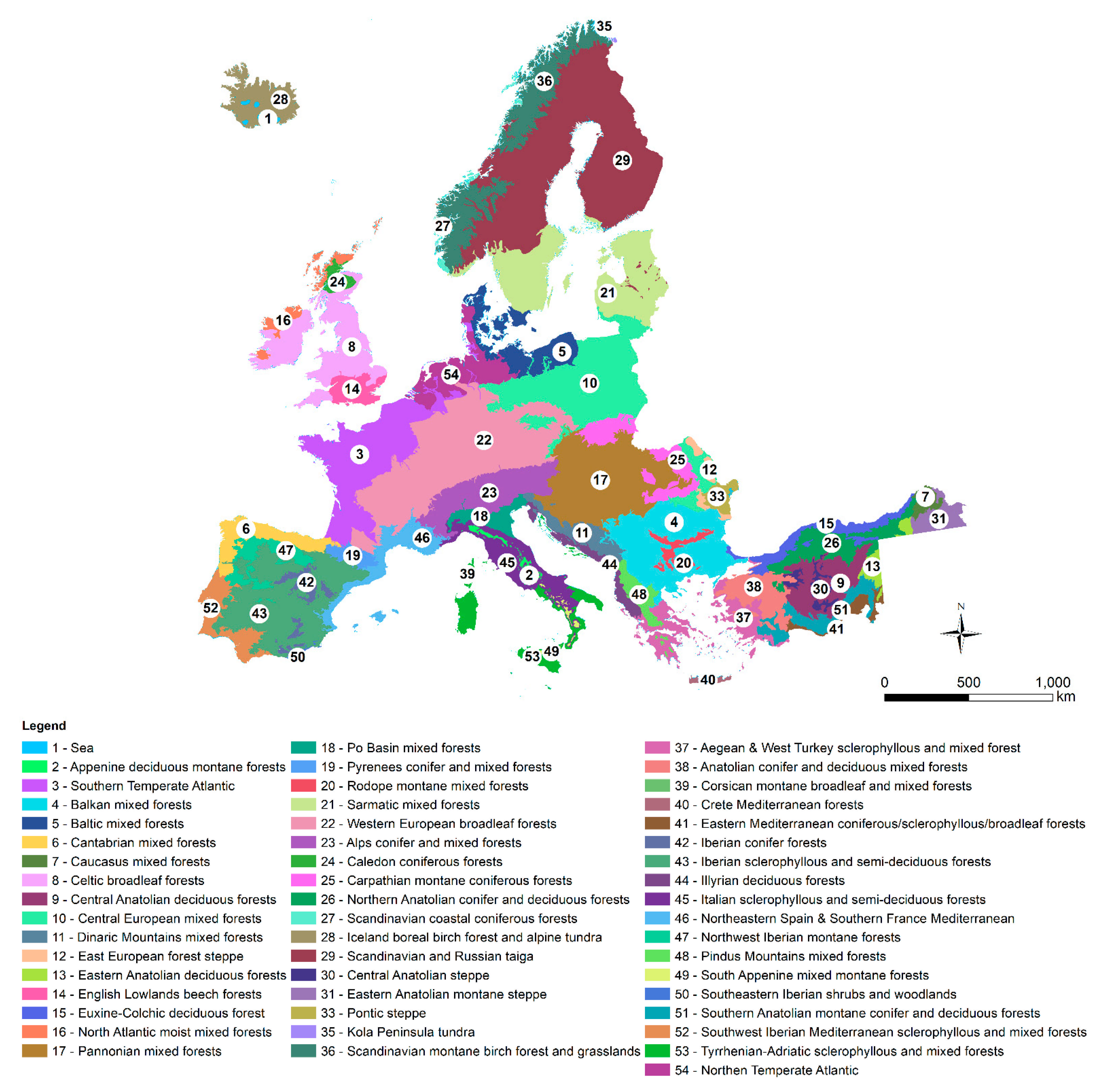
  • Attributing ES values: We generated maps for each ES and both time steps (2000 and 2018) by attributing ES values to the respective LULC type (Table A2). Since some LULC types were missing in Tasser et al. [7], we integrated ES values from other studies [52,55,56]. Moreover, we distinguished raster cells with slope < and ≥30° for a refined mapping of protection from hazards (R1) by adapting ES supply [57,58] and set the sociocultural preference to 1 in areas with a slope below 30°, as there is no demand for this ES. The resulting ES maps had high spatial resolutions (100 × 100 m) and needed to be converted to a coarser scale to depict trends at the European level. We used a map of European ecological regions [59] (henceforth referred as ecoregions) at a scale of 1:2.5 million (Figure A1) to calculate area-weighted mean values for each ES and each ecoregion from the fine-scale raster maps. The ecoregions represent relatively homogeneous ecological conditions and were delimited based on climatic, topographic and geobotanical data by a large team of experts from several European nature-related institutions and the WWF [59].
  • Cluster analysis: Due to the high number of ecoregions (n = 52), we applied cluster analysis to group ecoregions with similar LULC composition as well as similar LULC changes. We applied hierarchical cluster analysis in SPSS Statistics (version 26, IBM, Armonk, NY, USA) using the squared Euclidean distance to measure the dissimilarity of the variables and applied Ward’s linkage method to aggregate the clusters.
  • Analysing impacts: To depict characteristics and trends in LULC and ES values at the ecoregional level, we first calculated area-weighted mean values of LULC types and ES values for each ecoregion and each cluster based on the raster maps (generated in steps 1 and 2). Changes in LULC and ES values between 2000 and 2018 were then derived for each ecoregion by calculating the differences between the two time steps.

3. Results

3.1. Spatial Patterns and Trends in ES Values

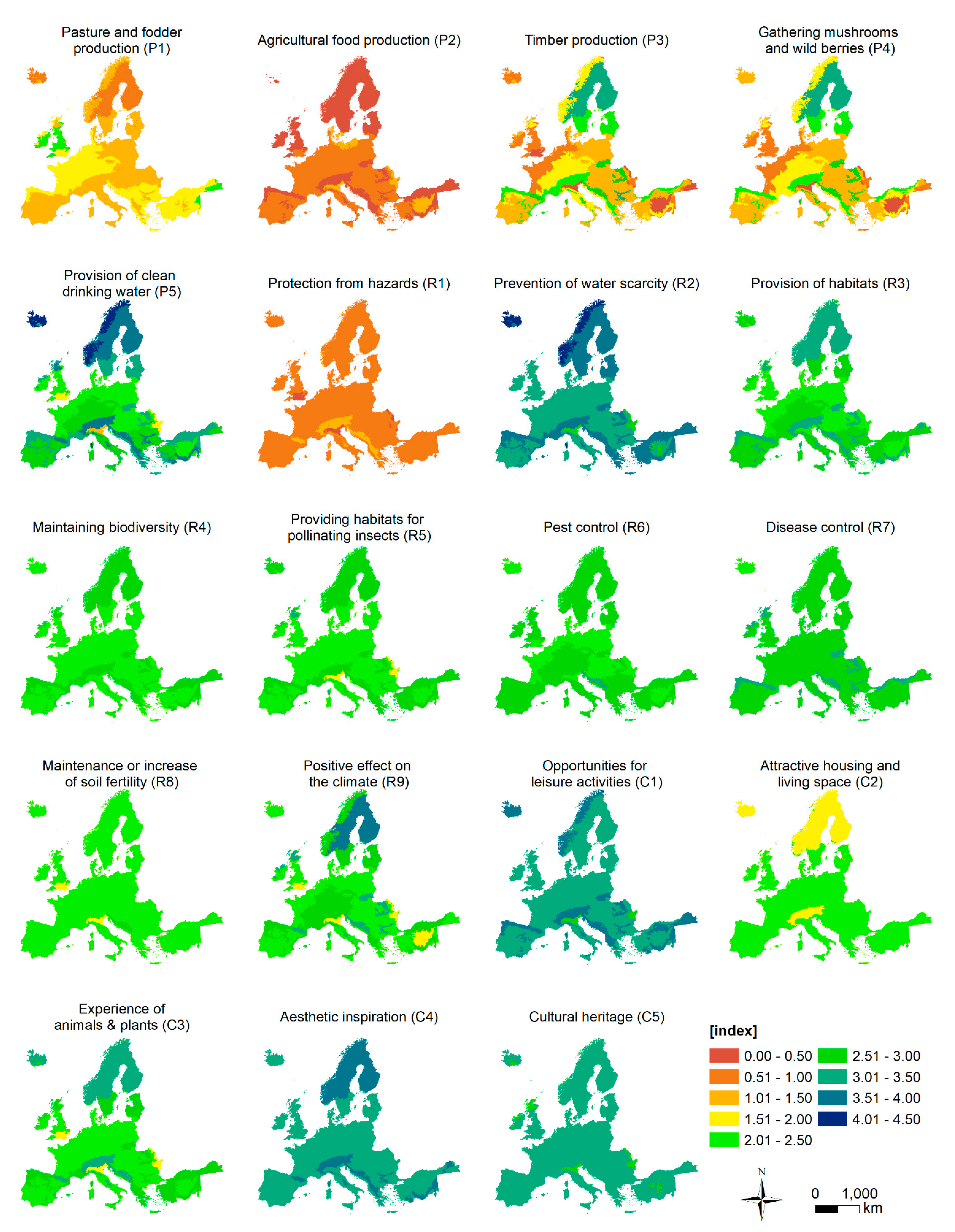
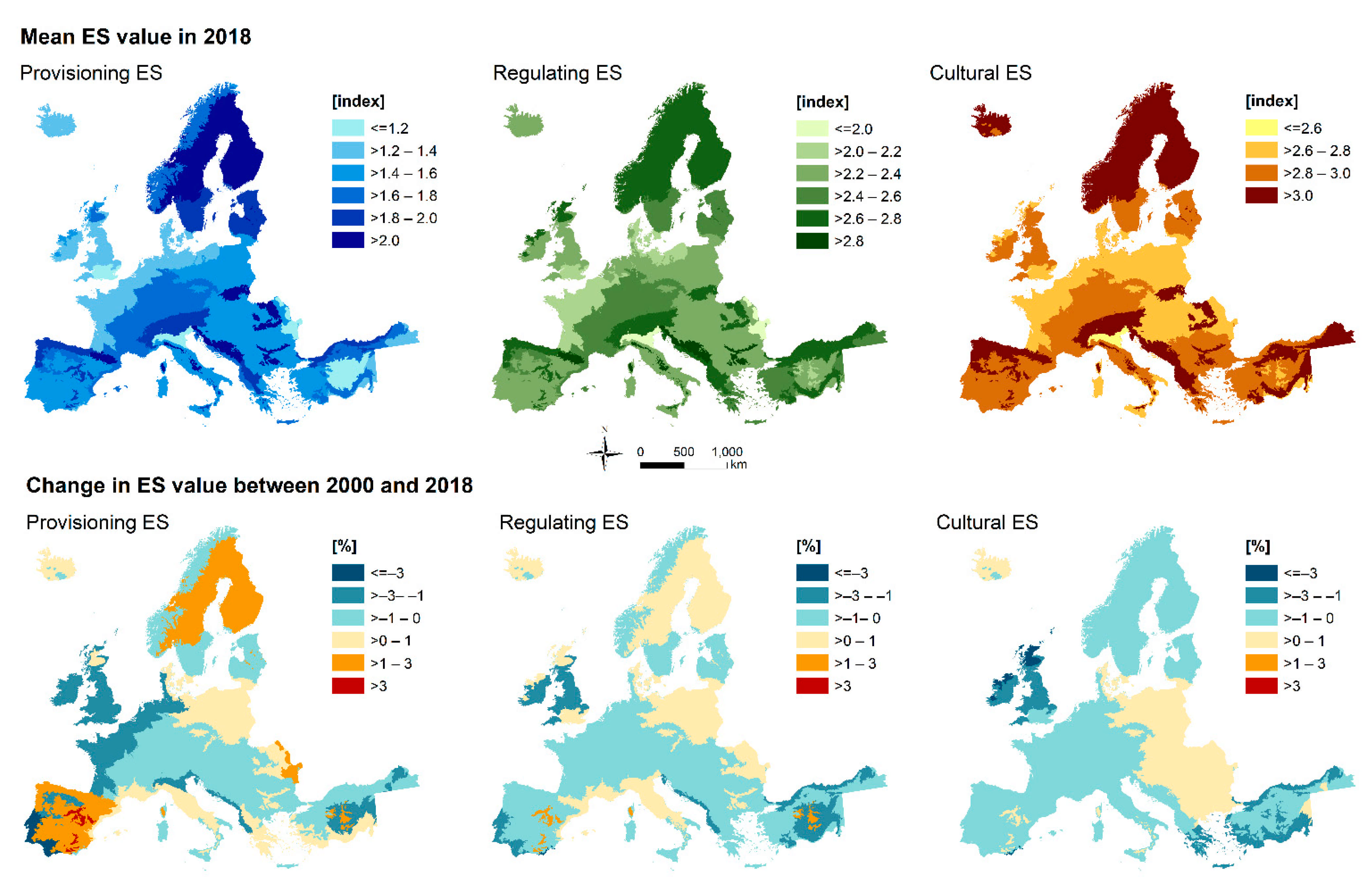
ES values varied considerably across ecoregions (Figure A2). They also differed significantly in the three ES categories (Figure 2, Figure A3). The lowest values, on average, occurred for provisioning ES (maximum value = 2.2) due to a limited number of ES with high ES values for each LULC type. For example, food and fodder are mainly produced on agricultural land, while timber, mushrooms and wild berries grow mainly in forests (Table A1 and Table A2). Ecoregions with a high share of intensive agricultural land cover types (i.e., permanent crops, arable land, and fertilised grassland) had clearly lower ES values than ecoregions with a high proportion of forest. This difference was amplified for regulating and cultural ES, for which mean ES values were highest in ecoregions with a high proportion of forest or other seminatural LULC types (e.g., unfertilised grasslands, shrubs). Such LULC types are important; they protect against hazards (R1), increase the availability of usable water (R2), host many habitats and species (R3, R4, and R5), have positive effects on climate (R9), provide opportunities for recreation and aesthetic experiences (C1–C4), and are culturally valuable (C5). In contrast, the lowest ES values for regulating and cultural ES are found in ecoregions with a high proportion of arable land and permanent crops.
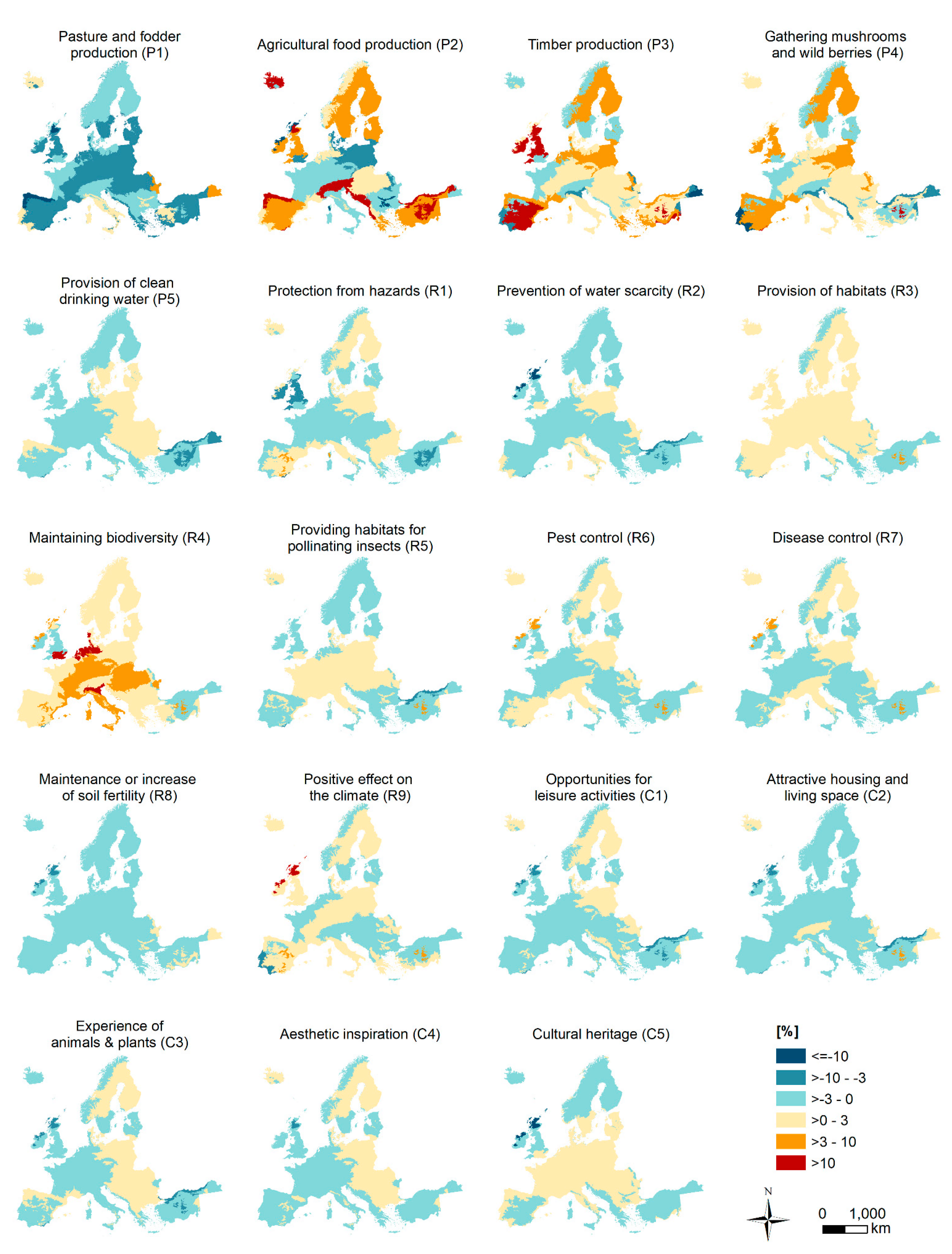
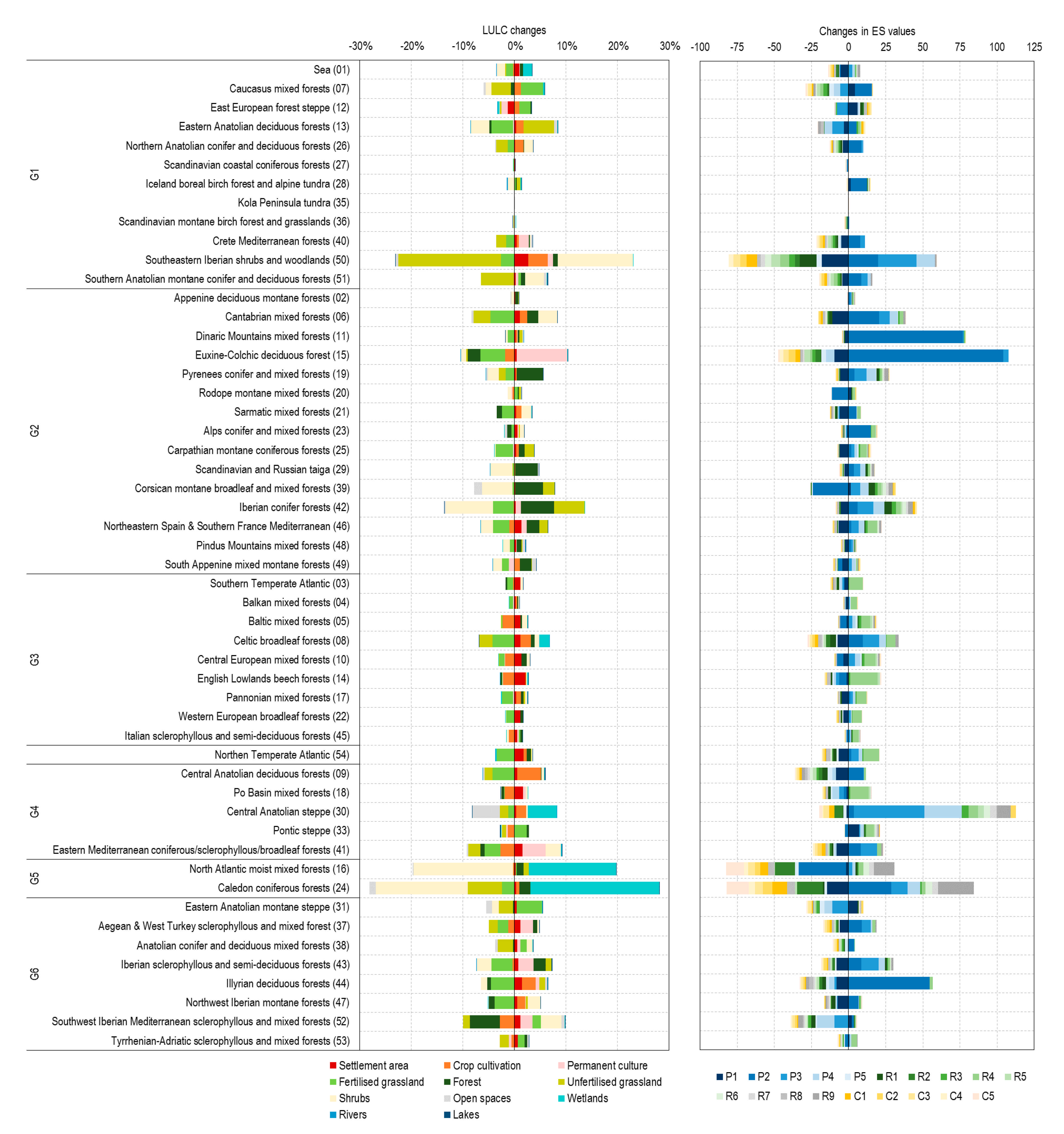
Changes in ES values between 2000 and 2018 also varied among individual ES (Figure A4), but overall changes were generally low for the three ES categories (Figure 2, Figure A5). The largest changes in ES values occurred for provisioning ES. ES values increased over large areas in the Scandinavian countries and the Iberian Peninsula, as well as in Corsica and in the eastern European forest steppe. In contrast, provisioning ES decreased in several parts of the Iberian Atlantic coast, in the intensively-used northern European coastal regions, in Great Britain and Ireland, in the Po Valley in Italy, along the coast of the Balkans, and in the Central Anatolian Highland. Changes in regulating and cultural ES were of lower magnitude. There was a small increase in regulating ES in the forested regions of Corsica and central Spain. On the other hand, they decreased in many coastal regions, in Great Britain and Ireland, and in the Anatolian Central Highlands. Cultural ES increased only slightly in some parts in Eastern Europe. Decreasing trends occurred mainly in Ireland and in the United Kingdom (particularly Scotland), as well as along the Greek and Turkish coastlines.

3.2. Regions with Similar LULC

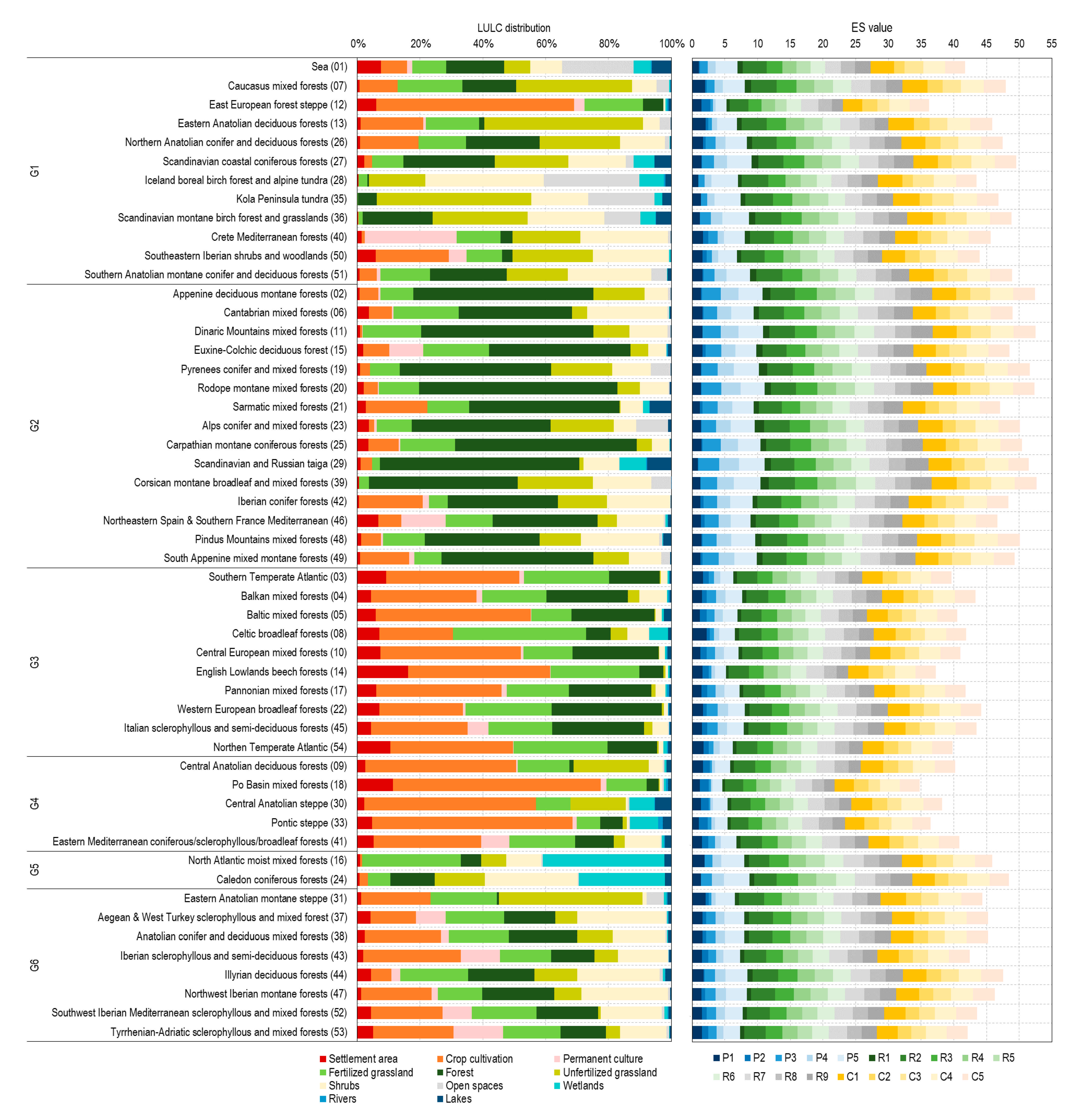
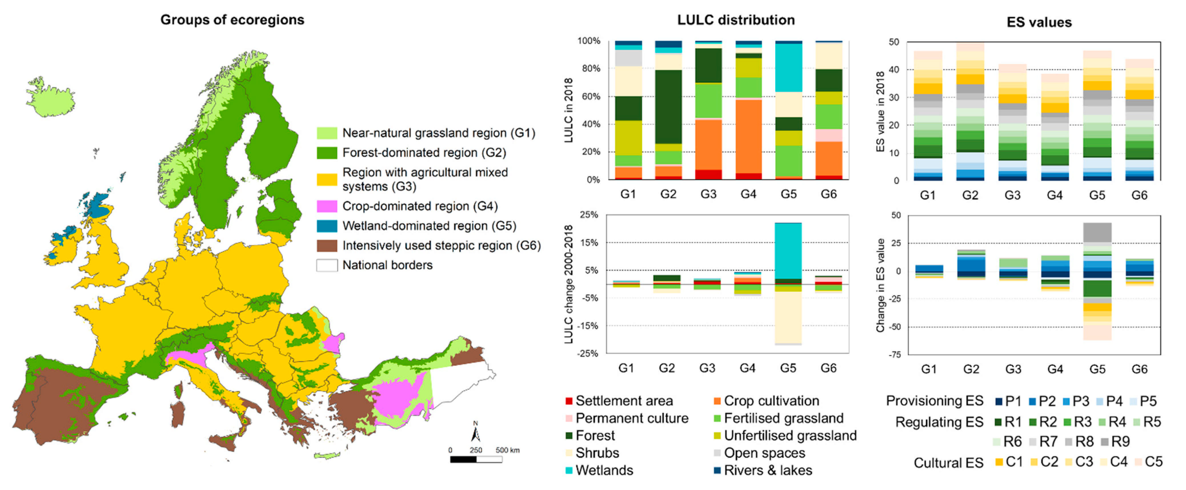
The 52 ecoregions were grouped into six major regions with similar LULC distribution and trend by hierarchical cluster analysis to identify general patterns and trends in ES values across Europe (Figure 3).
The near-natural grassland region (G1) comprises 12 ecoregions that are predominantly covered by seminatural land cover types (e.g., unfertilised grasslands, shrubs, forest, and open habitats, covering about 82% of the land, with 18% of the area intensively-used). Ecoregions belonging to this group are mainly found in Iceland, the Scandinavian mountains, and the Turkish Pontic and Taurus mountains.
The forest-dominated region (G2) consists of 15 ecoregions that are mainly covered by forests and shrubs (64% of the area). Intensively-used land for agriculture (18%) and unfertilised grasslands (5%) decreased significantly in favour of forests over the past 20 years. This group mainly includes ecoregions located in the Scandinavian countries as well as mountainous ecoregions in central and southern Europe.
The region with agricultural mixed systems (G3) includes 10 ecoregions and is dominated by crop cultivations (36%), fertilised grassland (24%), and forest (25%). In addition, settlement areas, which have increased significantly over the past 20 years at the expense of arable land, account for 7%. This group dominates in Ireland, Great Britain, central and eastern Europe, and parts of central Italy.
The crop-dominated region (G4) contains five ecoregions and is predominantly used for crop cultivation (53% of the area with increasing trend), with a further 30% used for other agricultural purposes. The Po Valley in Italy, the Pontic-Caspian steppe, and the central Anatolian highlands belong to this group.
The wetland-dominated region (G5) comprises two ecoregions in Northern Ireland and Scotland. Wetland habitats (34%) and grasslands (33%) are the main LULC types, followed by shrubs (18%) and forests (9%). Between 2000 and 2018, wetlands and forest increased at the expense of unfertilised grassland and shrubs.
Finally, the intensively-used steppic region (G6) includes 8 ecoregions in which 61% of the area is used for agriculture. Forest cover accounts for only 16% of the area, with another 18% being drought-resistant shrub vegetation. This group is mainly found in the drylands and coastal regions of the Mediterranean.

3.3. Change Patterns in ES Values

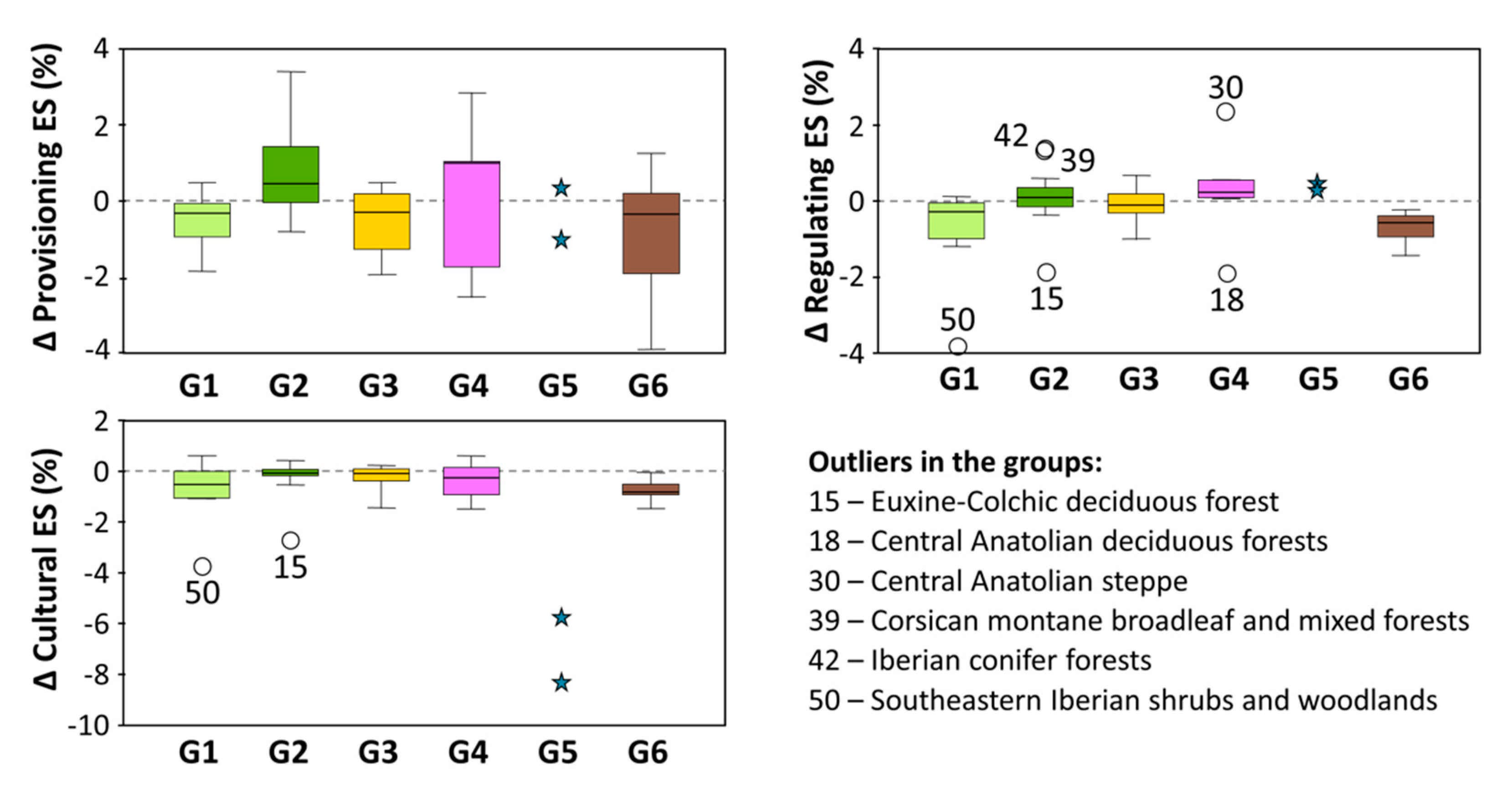
Ecoregions belonging to the same identified group generally had similar trends in ES values (Figure 4, Figure A6, Figure A7 and Figure A8), but there were outliers. A slight decrease in provisioning ES occurred in the near-natural grassland region (G1), the region with agricultural mixed systems (G3) and the intensively-used steppic region (G6), whereas provisioning ES increased in the forest-dominated region (G2). No clear trends were identified for the crop-dominated region (G4) or the wetland-dominated region (G5). Looking at LULC changes in G5, the area used for agriculture decreased significantly (−32%) over the past 20 years in favour of wetlands and forests in ecoregion 16 (North Atlantic moist mixed forests ecoregion), resulting in a decrease in agricultural food production (P2). In contrast, agricultural food production increased by 28% in the Scottish inland (24, the Caledon coniferous forest ecoregion), while significantly more fertilised grassland (−14%) was abandoned, leading to the difference in pasture and fodder production (P1) between the two ecoregions.
Compared to provisioning ES, the variance within and between the groups was lower for regulating ES. In general, regulating ES decreased in G1 and G6 and slightly increased in G4 and G5. The ecoregions within G2 and G3 had no clear trend. However, several outliers showed significantly larger changes in ES values. The large spatial expansion of urban areas along the coast resulted in a greater decline of regulating ES in ecoregion 50 (southeastern Iberian shrubs and woodlands) compared to the average development in G1. Meanwhile, unfertilised grasslands in the hinterland were increasingly abandoned or transformed to crop cultivations and permanent cultures at favourable sites. Diverging trends in forest cover in G2 also led to large changes in regulating ES. Forest areas and unfertilised grassland areas increased at the expense of intensive agricultural areas in ecoregions 39 (Corsican montane broadleaf and mixed forests) and 42 (Iberian conifer forests), resulting in a strong increase in ES values. In contrast, permanent cultures (especially tea and citrus plantations) expanded at the expense of forest in ecoregion 15 (Euxine-Colchic deciduous forest), leading to a decrease in regulating ES. Outliers in G4 can be associated with differing change rates from grassland to arable land. In ecoregion 30 (central Anatolian steppe), the increase was below average, while it was clearly above average in ecoregion 18 (central Anatolian deciduous forests).
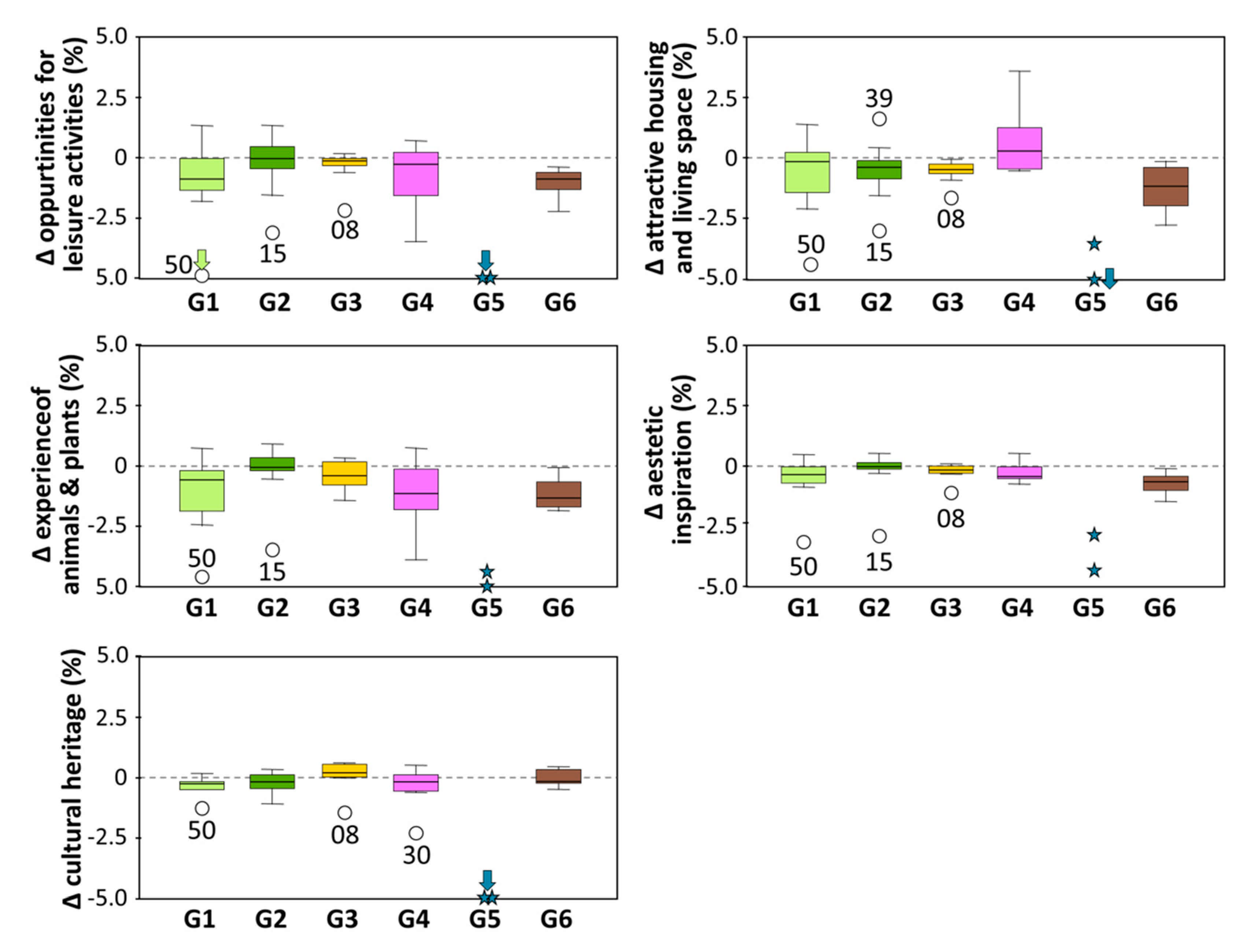
Cultural ES had generally low negative trends, except for G5, for which cultural ES decreased, on average, by 7%. Outliers included ecoregion 50 (southeastern Iberian shrubs and woodlands) in G1, where urban areas along the coast increased but unfertilised grassland was abandoned. In ecoregion 15 (Euxine-Colchic deciduous forest), intensively-used agricultural land increased at the expense of forest. The great decline in cultural ES in ecoregions of G5 can be attributed to the increase in wetlands, which have generally lower cultural ES than unfertilised grassland and shrubs (Table A2).

4. Discussion

4.1. General and Specific Trends in ES Values in Relation to LULC Changes

Our results indicated that ecoregions across Europe provide ES at different levels, depending on the LULC composition. This matched the findings of previous studies [3,4,5,28,35]. In general, ecoregions focusing on intensive agricultural production are characterised by lower ES values than ecoregions with a high share of seminatural LULC types such as forest, shrubs, and wetlands. Provisioning ES generally have lower ES values than regulating and cultural ES, primarily due to trade-offs among different LULC types [7,8], e.g., grasslands provide fodder, arable land produces crops, and forest is mainly used for timber and a few non-wood products. In contrast, most LULC types are associated with multiple regulating and cultural ES, albeit with differences in their potential to provide individual ES [7,60]. The level of provision varies among LULC types because of ecological processes and ecosystem structures [6,61]. For example, evapotranspiration increases significantly in leafy areas, dependent on water-spending strategies of plant species [62,63], leading to differences of LULC types in terms of water supply. Furthermore, LULC types differ in the level of human impact [6,61]; for example, the amount of fertiliser differs among different types of agricultural usage, but fertiliser reduces water quality due to higher nitrate concentrations in the seepage, higher phosphorus discharge and greater density of total coliforms in the surface and seepage water [7]. Finally, topographical characteristics influence ES—because protection against hazards and the protective functions of forests against avalanches, soil erosion, and rockfall increase along with slope inclination [57,58]. This was taken into account in this study.
While most ecoregions within the identified groups had similar trends in ES values, deeper analyses of the outliers are of interest, as these indicate developments that deviate from the general trend and are triggered by special frameworks. For provisioning ES, there were no outliers within the groups. Only the two ecoregions in G5 showed clear differences. The diverging trends are the result of clearly different developments in fertilised grassland between the two ecoregions, leading to high differences in pasture and fodder production (P1) and agricultural food production (P2). Both ecoregions are composed of mosaic of pastures, hay meadows, forests, heathland and moorland, but they are historically very diverse in landscape structure [64] and have developed differently over the past few decades. Agriculturally used areas were largely abandoned (−32%) in ecoregion 16 (North Atlantic moist mixed forests ecoregion), whereas agricultural food production increased by 28% at the expense of grassland in the Scottish Inland (24—Caledon coniferous forest ecoregion). These differences between neighbouring regions can be explained by contrasting socioeconomic developments. In contrast to ecoregion 16, ecoregion 24 showed prosperous economic development and high regional competitiveness [65]. The economic weakness of ecoregion 16 was also reflected in the above-average orientation of employment in agriculture and forestry, whereas in region 24 employment is increasingly found in the service sector [66]. Accordingly, ecoregion 24 is experiencing a slowdown in population development and migration from rural areas [66] with increased abandonment of agricultural land.
In terms of regulating ES, ecoregion 50 (Southeastern Iberian shrubs and woodlands) was far below the average of all other ecoregions in G1, especially regarding protection from hazards, prevention of water scarcity, providing habitats for pollinators, and pest control—all of which declined. This can be explained by high migration rates of people from the rural areas in the hinterland to cities along the coast, leading to an above-average increase in settlement area and a loss of forest areas and agricultural land [11]. In addition, the coastal plains around Almería are increasingly being used for intensive farming, particularly greenhouses [67]. In G2, the significantly lower regulating ES in ecoregion 15 can be attributed to above-average expansion and intensification of human use over the last 20 years. About 60% of the wetlands in the region were drained to permit installation of tea and citrus plantations and rural development projects [67]. In contrast, the above-average increase in regulating ES in ecoregions 39 (Corsican montane broadleaf and mixed forests) and 42 (Iberian conifer forests) can be attributed to the expansion of forest and unfertilised grassland at the expense of intensive agricultural areas. This development is not surprising in ecoregion 39, which is protected through the Regional Natural Park of Corsica, allowing nature develop largely undisturbed [68]. The Iberian Forest (ecoregion 42) is more developed for mountain tourism with facilities for skiing and roads [67]. These linear and small-scale developments are contrasted by a large-scale abandonment of agriculture, leading to significant reforestation of former pastures. Furthermore, many measures were implemented over time to protect infrastructures and to prevent clear-cutting, which also led to a reduction in erosion. Finally, there were two outliers within regulating ES in G4. The particularly negative development in ecoregion 18 (central Anatolian deciduous forests) is a result of the conversion of forest to fertilised grassland and arable land [68]. Additionally, some parts of that region are important winter tourism destinations with increasing infrastructure [67]. In contrast, ecoregion 30 (Central Anatolian steppe) consists of a mosaic of salt steppe around smaller saline lakes, salt marshes, seasonal freshwater wetlands, and upland steppes. Although the salt marshes and steppes do not support fodder of a quality preferred by livestock, much of the area has been overgrazed. In 2001, some areas were declared Specially Protected Areas; since then, Turkey’s authority has worked on reducing human impact in the area [67]. Accordingly, our results indicated the first positive developments. Moreover, the transformation of steppes to arable land was lower than in other ecoregions in G4, while seminatural grasslands and shrub vegetation increased more.
In the context of cultural ES, there were several outliers with particularly negative developments. The strong decrease in G1 of ecoregion 50 (southeastern Iberian shrubs and woodlands) is the result of increasing LULC types with low cultural ES values [7,52] (e.g., urban sprawl) in combination with an intensification of agricultural use in favourable areas and the abandonment of low-intensity agricultural activities [11]. The same applies to ecoregion 15 (Euxine-Colchic deciduous forest) in G2, which is characterised by an above-average expansion of intensive agricultural land (mainly permanent crops) at the expense of forest, leading to a decrease in cultural ES [7]. Cultural ES also declined strongly in both ecoregions in G4 due to an increase in wetland areas [56]. Additionally, favourable areas were converted from grassland to cropland in ecoregion 24. Arable land and wetland have lower cultural ES than the former LULC types [7,56], which explains the negative developments.

4.2. Limitations and Future Prospects

ES mapping approaches are based on LULC distribution are easily applicable, cost-efficient, and suitable for monitoring purposes, as impacts on ES values can be directly depicted [60]. The resulting maps provide synthesised information of highly complex processes and are easily comprehensible by a broader audience, while sufficiently reflecting the underlying mechanisms that are required for decision-making [69]. However, this simplicity also contains uncertainties, which need to be considered when using ES maps to develop management strategies and policies.
First, the thematic resolution of the LULC maps and related ES values may not sufficiently distinguish LULC types with distinct ecological functions and processes—although we used a differentiated classification of LULC types [7]. By assigning the same ES value to a specific LULC type in different regions across Europe, specific ecological functions and processes at local and regional scales are neglected [70]. For example, a forest in southern Europe with a dry and warm climate includes tree species that differ from a forest in Scandinavia or a high mountain forest [71]. Furthermore, variations in forestry systems are largely neglected, but mixed forests provide higher levels of most ES—as well as higher biodiversity—compared to monocultures [72]. Additionally, changes over time within seminatural LULC types, such as the densification of shrubs and forests [10], are not reflected. With regard to different types of agricultural use, which are generally related to different levels of fertiliser input, species composition, and ecological processes, we distinguished four different types (i.e., crop production, permanent cultures, fertilised and unfertilised grassland). Further grassland types could be distinguished, e.g., hay meadows, with different levels of fertilisation and differently stocked pastures [73,74]. The same is true of different types of annual and permanent crops [75], but this was not considered in this work due to the lack of spatial information at the European level. Moreover, ES maps could be refined by differentiating conventional and organic farming systems for annual and permanent crops, which largely differ in the provision of different ES [33,76,77]. Such changes in farming systems or cultivated crops did not result in LULC changes over the last 20 years and were not reflected in our change analysis. The integration of further LULC types and management systems, along with a refinement of ES values, may therefore improve mapping results.
Second, looking only at LULC composition may not be sufficient for capturing fine-scale landscape patterns that could alter ES values depending on the spatial configuration of individual LULC types. For example, crop production systems can vary in patch size from small fields with linear features (such as hedgerows) to large homogenous areas, greatly differing in the provision of habitat for pollinating insects [78,79] or pest control [80]. Moreover, landscape structure highly influences directional ecological processes. In this study, we integrated the effects of slope on protection from hazards, but other ES—for example, those related to hydrological processes—could be enhanced by accounting for flow direction [3,49,78].
Third, the use of CLC maps is related to mapping uncertainties due to changes in methodology over time and interpretation issues of remote sensing data [81]. We therefore concentrated on newer versions of CLC to reduce such mapping uncertainties at the expense of a limited period of analysis. While an intensification of agricultural use is immediately captured in LULC maps, land cover changes—such as natural forest regrowth in consequence of the abandonment of agricultural activities—occur very slowly [82], and longer monitoring periods are needed to provide deeper insights [34]. Considering only a short period of time, however, served to explain the low change rates in ES values in many ecoregions. For example, the greatest changes in land use, i.e., abandonment of mountain grassland and intensification of agricultural use in the valley, occurred in the European Alps around the 1960s–1970s and then slowed down [2]. Such land use changes from several decades ago are partly reflected in land cover changes and still influence ES supply today in case of a reduction of use [61,83]. Understanding such legacy effects is important for anticipating the consequences of today’s management decisions on future ES values [83,84,85,86].
Finally, sociocultural preferences for ES may vary between different regions or countries, considering the cultural diversity across Europe [87,88]. Nevertheless, considering such preferences is very important. For example, fertilised grassland is more productive than unfertilised grassland, but when also considering sociocultural preferences, unfertilised grassland shows higher ES values for most other ES [7,74]. Furthermore, it has to be considered that the ES values used in this study refer to the potential ES supply, i.e., the capacity of ecosystems to provide ES [60]. Our maps, therefore, do not reflect the actual use (i.e., flow) of ES, which varies greatly within and across regions depending on individual management decisions, accessibility, and the demand for ES [31,33,35,78]. To support the development of sustainable management strategies across various management and decision levels, further studies should integrate the ES demand, as spatial mismatches between supply and demand require the transfer of ES from areas that provide ES to areas where beneficiaries of ES are located, and vice versa [35,36,78,89].

5. Conclusions

Our results depict recent trends in multiple ES values across Europe. Based on LULC distribution and changes, we also identified groups of ecoregions with similar developments in ES values, as well as outliers with strongly different developments in ES values. A detailed analysis suggested that regional decisions could lead to significantly different developments, both positive and negative. The establishment of protected areas—and the resulting reduction in human use—generally led to an increase in regulating and cultural ES. A reduction in agricultural pressure led to comparable, albeit weakened, developments. In contrast, uncontrolled and massive urban sprawl and the conversion of grassland to arable farming, greenhouse crops, and permanent crops have had the opposite effect and led to a decline in many ES values.
Such findings can be useful for integrating ES into local and regional management decisions, in various European policies and EU missions that support the EU Green Deal, and can help to achieve Sustainable Development Goals. For example, our results revealed ecoregions with a strong decline in regulating and cultural ES due to agricultural intensification. A shift towards more sustainable management practices and measures to improve small-scale landscape heterogeneity could halt or revert current trends in ES and improve production-relevant ES, which would be supported by the CAP reform in the future. Our maps may provide an informational basis for identifying ecoregions where further conservation measures should be implemented to counterbalance negative trends in ES values. Our results may also be used for monitoring the effects of past conservation efforts and land use decisions. At the regional and national level, management decisions in ecoregions with undesired trends may be orientated on other ecoregions from the same groups that have contrasting developments. Here, specific actions may also be defined within EU mission areas to enhance the provision of ES.
However, it is apparent that important data on the management of different LULC types are missing. These data are necessary to concretise the consequences of individual developments on ES. This would also require an expansion of European databases with homogenised spatial management data, as well as an improvement of content-related information and better spatial resolution of LULC types. Above all, data collection should be focused on cutting frequency and fertiliser intensity in grassland, grazing intensity in pastures, and farming systems for arable and permanent crop use, i.e., whether conventional or organic. This would allow for more detailed and targeted statements on the consequences of political decisions in the future.

Author Contributions

Conceptualization, U.S. and E.T.; methodology, U.S. and E.T.; formal analysis, U.S. and E.T.; writing—original draft preparation, U.S. and E.T.; writing—review and editing, U.S. and E.T.; visualization, U.S. All authors have read and agreed to the published version of the manuscript.

Funding

This research received no external funding.

Institutional Review Board Statement

Not applicable.

Informed Consent Statement

Not applicable.

Data Availability Statement

All data that were used for analysis are publicly available. Data sources are indicated. Authors’ own elaborations are available in Appendix A.

Conflicts of Interest

The authors declare no conflict of interest.

Appendix A

Figure A1. Ecoregions representing relatively homogeneous ecological conditions. Data source: [59] (authors’ own elaboration).
Sustainability 13 07095 g0a1
Table A1. LULC types aggregated from CLC classes [53].
LULC TypeCLC Classes
Settlement area111, 112, 121, 122, 123, 124, 131, 132, 133, 141, 142
Crop cultivation211, 212, 213, 241
Permanent culture221, 222, 223
Fertilised grassland231, 242, 243, 244
Unfertilised grassland321, 333
Forest311, 312, 313
Shrubs322, 323, 324
Open spaces331, 332, 334, 335
Wetlands411, 412, 421, 422, 423
Rivers511
Lakes512, 521, 522, 523
Table A2. ES values (ES supply weighted with socio-cultural preferences) for different LULC types.
ESSettlement AreaCrop CultivationPermanent CultureFertilised Grassland Unfertilised Grassland Forest Shrubs Open Spaces Wetlands Rivers Lakes Socio-Cultural Preference
Pasture and fodder production (P1)0.00 a0.86 h0.85 h4.04 h2.23 h0.77 h1.06 h0.00 a0.77 a0.00 a0.00 a4.15 h
Agricultural food production (P2)0.00 a2.06 h2.86 h0.00 h0.00 h0.00 h0.00 h0.00 a0.00 a0.00 a0.00 a4.29 h
Timber production (P3)0.00 a0.00 h2.18 h0.02 h0.67 h4.53 h1.66 h0.00 a1.66 a1.66 a0.00 a4.18 h
Gathering mushrooms and wild berries (P4)0.00 a0.10 h0.17 h0.45 h0.97 h4.18 h1.77 h0.00 a1.77 a0.00 a0.00 a4.19 h
Provision of clean drinking water (P5)0.29 b1.19 h1.81 h2.39 h3.91 h4.09 h4.43 h3.98 b3.95 b4.03 b4.03 b4.52 h
Protection from hazards (R1a), slope <30°0.00 a0.30 a0.69 a0.73 a0.79 a0.94 a0.54 a0.30 i0.54 i2.50 i3.00 i1.00 h
Protection from hazards (R1b), slope >30°0.00 a1.27 h2.93 h3.13 h3.38 h4.00 h2.30 h1.00 i1.90 i2.50 i3.00 i4.27 h
Prevention of water scarcity (R2)3.03 c2.40 h2.46 h4.09 h4.34 h3.72 h4.34 h4.10 c1.56 c3.90 c3.90 c4.45 h
Provision of habitats (R3)2.63 d1.77 h1.97 h2.20 h3.71 h3.67 h3.38 h1.14 d3.39 d2.25 d0.25 d4.61 h
Maintaining biodiversity (R4)2.34 d1.95 h1.72 h2.13 h3.41 h3.03 h2.72 h1.01 d3.01 d2.00 d0.22 d4.26 h
Providing habitats for pollinating insects (R5)2.37 d1.40 h1.40 h2.47 h3.64 h2.99 h3.21 h1.03 d3.06 d2.030.23 d4.20 h
Pest control (R6)2.47 d1.88 h2.72 h2.78 h3.12 h3.21 h2.62 h1.07 d3.19 d2.11 d0.24 d3.72 h
Disease control (R7)2.64 d2.42 h2.77 h3.11 h3.24 h3.26 h2.92 h1.14 d3.41 d2.26 d0.25 d4.01 h
Maintenance or increase of soil fertility (R8)0.00 a1.98 h2.29 h2.77 h2.37 h2.48 h2.57 h1.49 i1.98 i2.47 i3.46 i3.64 h
Positive effect on the climate (R9)1.30 e1.29 h2.37 h2.11 h2.28 h4.11 h2.69 h1.85 e5.00 e1.08 e1.08 e4.38 h
Opportunities for leisure activities (C1)2.64 f2.83 h2.41 h3.58 h4.55 h3.60 h3.56 h3.92 f2.43 f3.49 f3.79 f4.59 h
Attractive housing and living space (C2)1.76 a2.30 h1.35 h2.56 h2.61 h1.91 h2.16 h0.00 a1.67 a2.14 a2.27 a3.04 h
Experience of animals & plants (C3)0.79 f1.65 h1.54 h2.15 h3.21 h3.26 h3.16 h3.56 f2.47 f3.72 f3.68 f4.46 h
Aesthetic inspiration (C4)2.56 f3.06 h2.45 h3.30 h3.82 h3.63 h3.55 h3.15 f2.99 f4.31 f4.66 f4.35 h
Cultural heritage (C5)3.86 f2.82 h2.83 h3.16 h3.59 h3.24 h3.75 h2.43 f1.59 f2.43 f2.34 f4.25 h
Provisioning ES0.06 g0.84 g1.57 g1.38 g1.56 g2.71 g1.78 g0.80 g1.63 g1.14 g0.81 g
Regulating ES1.87 g1.71 g2.04 g2.49 g2.99 g3.05 g2.78 g1.46 g2.79 g2.29 g1.40 g
Cultural ES2.32 g2.53 g2.12 g2.95 g3.56 g3.13 g3.24 g2.61 g2.23 g3.22 g3.35 g
Sources: a own assessment; b inverse of Nitrogen export [55]; c inverse of quick flow [55]; d calculated via plant diversity [90]; e Carbon sequestration of open grassland, [55]; f derived after [52]; g own calculation (mean of all ES within ES category); h [7]; i derived from Table 3.1 in [56].
Figure A2. ES values of individual ES for ecoregions across Europe in 2018 (authors own elaboration).
Sustainability 13 07095 g0a2
Figure A3. LULC distribution and ES values for ecoregions in Europe grouped by cluster analysis. (G1) near-natural grassland region, (G2) forest-dominated region, (G3) region with agricultural mixed systems, (G4) crop-dominated region, (G5) wetland-dominated region, and (G6) intensively-used steppic regions. Provisioning ES: pasture and fodder production (P1), agricultural food production (P2), timber production (P3), gathering mushrooms and wild berries (P4), provision of clean drinking water (P5); Regulating ES: protection from hazards (R1), prevention of water scarcity (R2), provision of habitats (R3), maintaining biodiversity (R4), providing habitats for pollinating insects (R5), pest control (R6), disease control (R7), maintenance or increase of soil fertility (R8), positive effect on the climate (R9); Cultural ES: opportunities for leisure activities (C1), attractive housing and living space (C2), experience of animals & plants (C3), aesthetic inspiration (C4), cultural heritage (C5). Authors’ own elaboration.
Sustainability 13 07095 g0a3
Figure A4. Change in ES values of individual ES for ecoregions across Europe between 2000 and 2018 (authors’ own elaboration).
Sustainability 13 07095 g0a4
Figure A5. Changes in LULC distribution and ES values for ecoregions in Europe between 2000 and 2018, grouped by cluster analysis ((G1) near-natural grassland region, (G2) forest-dominated region, (G3) region with agricultural mixed systems, (G4) crop-dominated region, (G5) wetland-dominated region, and (G6) intensively-used steppic regions). Provisioning ES: pasture and fodder production (P1), agricultural food production (P2), timber production (P3), gathering mushrooms and wild berries (P4), provision of clean drinking water (P5); Regulating ES: protection from hazards (R1), prevention of water scarcity (R2), provision of habitats (R3), maintaining biodiversity (R4), providing habitats for pollinating insects (R5), pest control (R6), disease control (R7), maintenance or increase of soil fertility (R8), positive effect on the climate (R9); Cultural ES: opportunities for leisure activities (C1), attractive housing and living space (C2), experience of animals & plants (C3), aesthetic inspiration (C4), cultural heritage (C5). Authors’ own elaboration.
Sustainability 13 07095 g0a5
Figure A6. Changes in provisioning ES between 2000 and 2018 for six groups of ecoregions: (G1) near-natural grassland region, (G2) forest-dominated region, (G3) region with agricultural mixed systems, (G4) crop-dominated region, (G5) wetland-dominated region, and (G6) intensively-used steppic regions. Circles indicate outliers and stars represent single values. Outliers include ecoregions 08—Celtic broadleaf forests, 15—Euxine-Colchic deciduous forest, 30—central Anatolian steppe, 39—Corsican montane broadleaf and mixed forests, 50—southeastern Iberian shrubs and woodlands. Authors’ own elaboration.
Sustainability 13 07095 g0a6
Figure A7. Changes in regulating ES between 2000 and 2018 for six groups of ecoregions: (G1) near-natural grassland region, (G2) forest-dominated region, (G3) region with agricultural mixed systems, (G4) crop-dominated region, (G5) wetland-dominated region, and (G6) intensively-used steppic regions. Circles indicate outliers and stars represent single values. Outliers include ecoregions 14—English Lowlands beech forests, 15—Euxine-Colchic deciduous forest, 30—central Anatolian steppe, 39—Corsican montane broadleaf and mixed forests, 42—Iberian conifer forests, 46—northeastern Spain & southern France Mediterranean, 50—southeastern Iberian shrubs and woodlands. Authors’ own elaboration.
Sustainability 13 07095 g0a7
Figure A8. Changes in cultural ES between 2000 and 2018 for six groups of ecoregions: (G1) near-natural grassland region, (G2) forest-dominated region, (G3) region with agricultural mixed systems, (G4) crop-dominated region, (G5) wetland-dominated region, and (G6) intensively-used steppic regions. Circles indicate outliers and stars represent single values. Outliers include ecoregions 08—Celtic broadleaf forests, 15—Euxine-Colchic deciduous forest, 30—central Anatolian steppe, 39—Corsican montane broadleaf and mixed forests, 50—southeastern Iberian shrubs and woodlands. Authors’ own elaboration.
Sustainability 13 07095 g0a8

References

  1. De Groot, R.S.; Alkemade, R.; Braat, L.; Hein, L.; Willemen, L. Challenges in integrating the concept of ecosystem services and values in landscape planning, management and decision making. Ecol. Complex. 2010, 7, 260–272. [Google Scholar] [CrossRef]
  2. Egarter Vigl, L.; Schirpke, U.; Tasser, E.; Tappeiner, U. Linking long-term landscape dynamics to the multiple interactions among ecosystem services in the European Alps. Landsc. Ecol. 2016, 31, 1903–1918. [Google Scholar] [CrossRef] [Green Version]
  3. Stürck, J.; Schulp, C.J.E.; Verburg, P.H. Spatio-temporal dynamics of regulating ecosystem services in Europe—The role of past and future land use change. Appl. Geogr. 2015, 63, 121–135. [Google Scholar] [CrossRef]
  4. Metzger, M.J.; Rounsevell, M.D.A.; Acosta-Michlik, L.; Leemans, R.; Schröter, D. The vulnerability of ecosystem services to land use change. Agric. Ecosyst. Environ. 2006, 114, 69–85. [Google Scholar] [CrossRef]
  5. Polce, C.; Maes, J.; Brander, L.; Cescatti, A.; Baranzelli, C.; Lavalle, C.; Zulian, G. Global change impacts on ecosystem services: A spatially explicit assessment for Europe. One Ecosyst. 2016, 1, e9990. [Google Scholar] [CrossRef] [Green Version]
  6. Lavorel, S.; Grigulis, K.; Leitinger, G.; Kohler, M.; Schirpke, U.; Tappeiner, U. Historical trajectories in land use pattern and grassland ecosystem services in two European alpine landscapes. Reg. Environ. Chang. 2017, 17, 2251–2264. [Google Scholar] [CrossRef]
  7. Tasser, E.; Schirpke, U.; Zoderer, B.M.; Tappeiner, U. Towards an integrative assessment of land-use type values from the perspective of ecosystem services. Ecosyst. Serv. 2020, 42, 101082. [Google Scholar] [CrossRef]
  8. Spake, R.; Lasseur, R.; Crouzat, E.; Bullock, J.M.; Lavorel, S.; Parks, K.E.; Schaafsma, M.; Bennett, E.M.; Maes, J.; Mulligan, M.; et al. Unpacking ecosystem service bundles: Towards predictive mapping of synergies and trade-offs between ecosystem services. Glob. Environ. Chang. 2017, 47, 37–50. [Google Scholar] [CrossRef] [Green Version]
  9. Falcucci, A.; Maiorano, L.; Boitani, L. Changes in land-use/land-cover patterns in Italy and their implications for biodiversity conservation. Landsc. Ecol. 2007, 22, 617–631. [Google Scholar] [CrossRef]
  10. Xystrakis, F.; Psarras, T.; Koutsias, N. A process-based land use/land cover change assessment on a mountainous area of Greece during 1945–2009: Signs of socio-economic drivers. Sci. Total Environ. 2017, 587–588, 360–370. [Google Scholar] [CrossRef]
  11. García-Nieto, A.P.; Geijzendorffer, I.R.; Baró, F.; Roche, P.K.; Bondeau, A.; Cramer, W. Impacts of urbanization around Mediterranean cities: Changes in ecosystem service supply. Ecol. Indic. 2018, 91, 589–606. [Google Scholar] [CrossRef] [Green Version]
  12. Balzan, M.V.; Sadula, R.; Scalvenzi, L. Assessing Ecosystem Services Supplied by Agroecosystems in Mediterranean Europe: A Literature Review. Land 2020, 9, 245. [Google Scholar] [CrossRef]
  13. Guo, Z.; Zhang, L.; Li, Y. Increased dependence of humans on ecosystem services and biodiversity. PLoS ONE 2010, 5. [Google Scholar] [CrossRef]
  14. Buckley, R.; Gretzel, U.; Scott, D.; Weaver, D.; Becken, S. Tourism megatrends. Tour. Recreat. Res. 2015, 40, 59–70. [Google Scholar] [CrossRef] [Green Version]
  15. Marando, F.; Salvatori, E.; Sebastiani, A.; Fusaro, L.; Manes, F. Regulating Ecosystem Services and Green Infrastructure: Assessment of Urban Heat Island effect mitigation in the municipality of Rome, Italy. Ecol. Modell. 2019, 392, 92–102. [Google Scholar] [CrossRef]
  16. Schröter, D.; Cramer, W.; Leemans, R.; Prentice, I.C.; Araújo, M.B.; Arnell, N.W.; Bondeau, A.; Bugmann, H.; Carter, T.R.; Gracia, C.A.; et al. Ecosystem Service Supply and Vulnerability to Global Change in Europe. Science 2005, 310, 1333–1337. [Google Scholar] [CrossRef] [Green Version]
  17. Bouwma, I.; Schleyer, C.; Primmer, E.; Winkler, K.J.; Berry, P.; Young, J.; Carmen, E.; Špulerová, J.; Bezák, P.; Preda, E.; et al. Adoption of the ecosystem services concept in EU policies. Ecosyst. Serv. 2018, 29, 213–222. [Google Scholar] [CrossRef]
  18. European Commission Green Infrastructure (GI)—Enhancing Europe’s Natural Capital. Communication from the Commission to the European Parliament, the Council, the European Economic and Social Committee and the Committee of the Regions. COM/2013/0249 Final. Available online: https://eur-lex.europa.eu/legal-content/EN/TXT/?uri=CELEX:52013DC0249 (accessed on 5 May 2021).
  19. European Commission EU Biodiversity Strategy for 2030. Bringing Nature Back into Our Lives. Communication from the Commission to the European Parliament, the Council, the European Economic and Social Committee and the Committee of the Regions. COM/2020/380 Final. Available online: https://eur-lex.europa.eu/legal-content/EN/TXT/?uri=CELEX:52020DC0380 (accessed on 5 May 2021).
  20. European Commission A New EU Forest Strategy: For Forests and the Forest-Based Sector. Communication from the Commission. COM/2013/0659 Final. Available online: https://eur-lex.europa.eu/legal-content/EN/TXT/?qid=1564480895507&uri=CELEX:52013DC0659 (accessed on 5 May 2021).
  21. European Commission Regulation (EU) No 1143/2014 of the European Parliament and of the Council of 22 October 2014 on the Prevention and Management of the Introduction and Spread of Invasive Alien Species. Available online: https://eur-lex.europa.eu/legal-content/EN/TXT/?uri=CELEX%3A02014R1143-20191214 (accessed on 5 May 2021).
  22. European Commission the Common Agricultural Policy at a Glance. Available online: https://ec.europa.eu/info/food-farming-fisheries/key-policies/common-agricultural-policy/cap-glance_en (accessed on 6 May 2021).
  23. European Commission Directive 2000/60/EC of the European Parliament and of the Council of 23 October 2000 Establishing a Framework for Community Action in the Field of Water Policy. Available online: https://eur-lex.europa.eu/legal-content/EN/TXT/?uri=CELEX%3A02000L0060-20141120 (accessed on 6 May 2021).
  24. Guy, P.; Birkenstock, M.; Lakner, S.; Röder, N. The Common Agricultural Policy post-2020: Views and Recommendations from Scientists to improve performance for biodiversity Volume 1—Synthesis Report; Thünen Working Paper; Johann Heinrich von Thuenen-Institut (vTI), Federal Research Institute for Rural Areas, Forestry and Fisheries: Braunschweig, Germany, 2021. [Google Scholar]
  25. European Commission Missions in Horizon Europe. Available online: https://ec.europa.eu/info/research-and-innovation/funding/funding-opportunities/funding-programmes-and-open-calls/horizon-europe/missions-horizon-europe_en (accessed on 14 June 2021).
  26. Burkhard, B.; Maes, J. (Eds.) Mapping Ecosystem Services; Pensoft Publishers: Sofia, Bulgaria, 2017. [Google Scholar]
  27. Maes, J.; Liquete, C.; Teller, A.; Erhard, M.; Paracchini, M.L.; Barredo, J.I.; Grizzetti, B.; Cardoso, A.; Somma, F.; Petersen, J.-E.; et al. An indicator framework for assessing ecosystem services in support of the EU Biodiversity Strategy to 2020. Ecosyst. Serv. 2016, 17, 14–23. [Google Scholar] [CrossRef] [Green Version]
  28. Schulp, C.J.E.; Van Teeffelen, A.J.A.; Tucker, G.; Verburg, P.H. A quantitative assessment of policy options for no net loss of biodiversity and ecosystem services in the European Union. Land Use Policy 2016, 57, 151–163. [Google Scholar] [CrossRef]
  29. Vallecillo, S.; Polce, C.; Barbosa, A.; Perpiña Castillo, C.; Vandecasteele, I.; Rusch, G.M.; Maes, J. Spatial alternatives for Green Infrastructure planning across the EU: An ecosystem service perspective. Landsc. Urban. Plan. 2018, 174, 41–54. [Google Scholar] [CrossRef]
  30. Turkelboom, F.; Leone, M.; Jacobs, S.; Kelemen, E.; García-Llorente, M.; Baró, F.; Termansen, M.; Barton, D.N.; Berry, P.; Stange, E.; et al. When we cannot have it all: Ecosystem services trade-offs in the context of spatial planning. Ecosyst. Serv. 2018, 29, 566–578. [Google Scholar] [CrossRef]
  31. Schirpke, U.; Candiago, S.; Egarter Vigl, L.; Jäger, H.; Labadini, A.; Marsoner, T.; Meisch, C.; Tasser, E.; Tappeiner, U. Integrating supply, flow and demand to enhance the understanding of interactions among multiple ecosystem services. Sci. Total Environ. 2019, 651, 928–941. [Google Scholar] [CrossRef] [PubMed]
  32. Cord, A.F.; Bartkowski, B.; Beckmann, M.; Dittrich, A.; Hermans-Neumann, K.; Kaim, A.; Lienhoop, N.; Locher-Krause, K.; Priess, J.; Schröter-Schlaack, C.; et al. Towards systematic analyses of ecosystem service trade-offs and synergies: Main concepts, methods and the road ahead. Ecosyst. Serv. 2017, 28, 264–272. [Google Scholar] [CrossRef]
  33. Schrama, M.; de Haan, J.J.; Kroonen, M.; Verstegen, H.; Van der Putten, W.H. Crop yield gap and stability in organic and conventional farming systems. Agric. Ecosyst. Environ. 2018, 256, 123–130. [Google Scholar] [CrossRef]
  34. Schirpke, U.; Tscholl, S.; Tasser, E. Spatio-temporal changes in ecosystem service values: Effects of land-use changes from past to future (1860–2100). J. Environ. Manag. 2020, 272, 111068. [Google Scholar] [CrossRef] [PubMed]
  35. Ala-Hulkko, T.; Kotavaara, O.; Alahuhta, J.; Hjort, J. Mapping supply and demand of a provisioning ecosystem service across Europe. Ecol. Indic. 2019, 103, 520–529. [Google Scholar] [CrossRef]
  36. Schirpke, U.; Tappeiner, U.; Tasser, E. A transnational perspective of global and regional ecosystem service flows from and to mountain regions. Sci. Rep. 2019, 9, 6678. [Google Scholar] [CrossRef] [PubMed] [Green Version]
  37. González-García, A.; Palomo, I.; González, J.A.; López, C.A.; Montes, C. Quantifying spatial supply-demand mismatches in ecosystem services provides insights for land-use planning. Land Use Policy 2020, 94, 104493. [Google Scholar] [CrossRef]
  38. Laroche, P.C.S.J.; Schulp, C.J.E.; Kastner, T.; Verburg, P.H. Telecoupled environmental impacts of current and alternative Western diets. Glob. Environ. Chang. 2020, 62, 102066. [Google Scholar] [CrossRef]
  39. Hauck, J.; Görg, C.; Varjopuro, R.; Ratamäki, O.; Maes, J.; Wittmer, H.; Jax, K. “Maps have an air of authority”: Potential benefits and challenges of ecosystem service maps at different levels of decision making. Ecosyst. Serv. 2013, 4, 25–32. [Google Scholar] [CrossRef]
  40. Paprotny, D.; Terefenko, P.; Giza, A.; Czapliński, P.; Vousdoukas, M.I. Future losses of ecosystem services due to coastal erosion in Europe. Sci. Total Environ. 2021, 760, 144310. [Google Scholar] [CrossRef]
  41. Grunewald, K.; Syrbe, R.-U.; Walz, U.; Richter, B.; Meinel, G.; Herold, H.; Marzelli, S. Germany’s Ecosystem Services—State of the Indicator Development for a Nationwide Assessment and Monitoring. One Ecosyst. 2017, 59–69. [Google Scholar] [CrossRef] [Green Version]
  42. García-Llamas, P.; Geijzendorffer, I.R.; García-Nieto, A.P.; Calvo, L.; Suárez-Seoane, S.; Cramer, W. Impact of land cover change on ecosystem service supply in mountain systems: A case study in the Cantabrian Mountains (NW of Spain). Reg. Environ. Chang. 2019, 19, 529–542. [Google Scholar] [CrossRef]
  43. Frélichová, J.; Fanta, J. Ecosystem service availability in view of long-term land-use changes: A regional case study in the czech republic. Ecosyst. Health Sustain. 2015, 1, 1–15. [Google Scholar] [CrossRef] [Green Version]
  44. Moreno-Llorca, R.; Vaz, A.S.; Herrero, J.; Millares, A.; Bonet-García, F.J.; Alcaraz-Segura, D. Multi-scale evolution of ecosystem services’ supply in Sierra Nevada (Spain): An assessment over the last half-century. Ecosyst. Serv. 2020, 46, 101204. [Google Scholar] [CrossRef]
  45. Zhang, W.; Ricketts, T.H.; Kremen, C.; Carney, K.; Swinton, S.M. Ecosystem services and dis-services to agriculture. Ecol. Econ. 2007, 64, 253–260. [Google Scholar] [CrossRef] [Green Version]
  46. Maes, J.; Egoh, B.; Willemen, L.; Liquete, C.; Vihervaara, P.; Schägner, J.P.; Grizzetti, B.; Drakou, E.G.; La Notte, A.; Zulian, G.; et al. Mapping ecosystem services for policy support and decision making in the European Union. Ecosyst. Serv. 2012, 1, 31–39. [Google Scholar] [CrossRef]
  47. Orsi, F.; Ciolli, M.; Primmer, E.; Varumo, L.; Geneletti, D. Mapping hotspots and bundles of forest ecosystem services across the European Union. Land Use Policy 2020, 99, 104840. [Google Scholar] [CrossRef]
  48. Dick, J.; Maes, J.; Smith, R.I.; Paracchini, M.L.; Zulian, G. Cross-scale analysis of ecosystem services identified and assessed at local and European level. Ecol. Indic. 2014, 38, 20–30. [Google Scholar] [CrossRef]
  49. Clerici, N.; Paracchini, M.L.; Maes, J. Land-cover change dynamics and insights into ecosystem services in European stream riparian zones. Ecohydrol. Hydrobiol. 2014, 14, 107–120. [Google Scholar] [CrossRef]
  50. Szumacher, I.; Pabjanek, P. Temporal Changes in Ecosystem Services in European Cities in the Continental Biogeographical Region in the Period from 1990–2012. Sustainability 2017, 9, 665. [Google Scholar] [CrossRef] [Green Version]
  51. Pecher, C.; Bacher, M.; Tasser, E.; Tappeiner, U. Agricultural landscapes between intensification and abandonment: The expectations of the public in a Central-Alpine cross-border region. Landsc. Res. 2018, 43, 428–442. [Google Scholar] [CrossRef]
  52. Zoderer, B.M.; Tasser, E.; Carver, S.; Tappeiner, U. An integrated method for the mapping of landscape preferences at the regional scale. Ecol. Indic. 2019, 106, 105430. [Google Scholar] [CrossRef]
  53. European Environment Agency Corine Land Cover (CLC) 2018, Version 2020_20u1. Available online: https://land.copernicus.eu/pan-european/corine-land-cover/clc2018 (accessed on 26 April 2021).
  54. European Environment Agency Corine Land Cover (CLC) 2000, Version 2020_20u1. Available online: https://land.copernicus.eu/pan-european/corine-land-cover/clc-2000 (accessed on 26 April 2021).
  55. Bagstad, K.J.; Ingram, J.C.; Lange, G.-M.; Masozera, M.; Ancona, Z.H.; Bana, M.; Kagabo, D.; Musana, B.; Nabahungu, N.L.; Rukundo, E.; et al. Towards ecosystem accounts for Rwanda: Tracking 25 years of change in flows and potential supply of ecosystem services. People Nat. 2020, 2, 163–188. [Google Scholar] [CrossRef]
  56. Millennium Ecosystem Assessment. Ecosystems and Human Well-BEING: Wetlands and Water Synthesis; Millennium Ecosystem Assessment: Washington, DC, USA, 2005. [Google Scholar]
  57. Wichmann, V. The Gravitational Process Path (GPP) model (v1.0)—A GIS-based Simulation Framework for Gravitational Processes. Geosci. Model. Dev. 2017, 10, 3309–3327. [Google Scholar] [CrossRef] [Green Version]
  58. Hungr, O.; Evans, S.G.; Bovis, M.J.; Hutchinson, J.N. A review of the classification of landslides of the flow type. Environ. Eng. Geosci. 2001, 7, 221–238. [Google Scholar] [CrossRef]
  59. European Environment Agency Digital Map of European Ecological Regions. Available online: https://www.eea.europa.eu/data-and-maps/data/digital-map-of-european-ecological-regions (accessed on 26 April 2021).
  60. Burkhard, B.; Kroll, F.; Nedkov, S.; Müller, F. Mapping ecosystem service supply, demand and budgets. Ecol. Indic. 2012, 21, 17–29. [Google Scholar] [CrossRef]
  61. Schirpke, U.; Leitinger, G.; Tasser, E.; Rüdisser, J.; Fontana, V.; Tappeiner, U. Functional spatial units are fundamental for modelling ecosystem services in mountain regions. Appl. Geogr. 2020, 118. [Google Scholar] [CrossRef]
  62. Brilli, F.; Hörtnagl, L.; Hammerle, A.; Haslwanter, A.; Hansel, A.; Loreto, F.; Wohlfahrt, G. Leaf and ecosystem response to soil water availability in mountain grasslands. Agric. For. Meteorol. 2011, 151, 1731–1740. [Google Scholar] [CrossRef] [PubMed] [Green Version]
  63. Tello-García, E.; Huber, L.; Leitinger, G.; Peters, A.; Newesely, C.; Ringler, M.-E.; Tasser, E. Drought- and heat-induced shifts in vegetation composition impact biomass production and water use of alpine grasslands. Environ. Exp. Bot. 2020, 169, 103921. [Google Scholar] [CrossRef]
  64. Joint Research Centre of the European Commission the Digital Observatory for Protected Areas (DOPA) Explorer 3.1: Caledon Conifer Forests. Available online: https://dopa-explorer.jrc.ec.europa.eu/ecoregion/80503 (accessed on 19 May 2021).
  65. European Commission the EU Regional Competitiveness Index 2019. Available online: https://ec.europa.eu/regional_policy/en/information/maps/regional_competitiveness/ (accessed on 19 May 2021).
  66. European Commission Eurostat Regional Yearbook 2019. Available online: https://ec.europa.eu/eurostat/web/products-statistical-books/-/ks-ha-19-001 (accessed on 19 May 2021).
  67. World Wildlife Fund Terrestrial Ecoregions. Available online: https://www.worldwildlife.org/biomes (accessed on 20 May 2021).
  68. Dinerstein, E.; Olson, D.; Joshi, A.; Vynne, C.; Burgess, N.D.; Wikramanayake, E.; Hahn, N.; Palminteri, S.; Hedao, P.; Noss, R.; et al. An Ecoregion-Based Approach to Protecting Half the Terrestrial Realm. Bioscience 2017, 67, 534–545. [Google Scholar] [CrossRef]
  69. Jacobs, S.; Burkhard, B.; Van Daele, T.; Staes, J.; Schneiders, A. ‘The Matrix Reloaded’: A review of expert knowledge use for mapping ecosystem services. Ecol. Modell. 2015, 295, 21–30. [Google Scholar] [CrossRef]
  70. Eigenbrod, F.; Armsworth, P.R.; Anderson, B.J.; Heinemeyer, A.; Gillings, S.; Roy, D.B.; Thomas, C.D.; Gaston, K.J. The impact of proxy-based methods on mapping the distribution of ecosystem services. J. Appl. Ecol. 2010, 47, 377–385. [Google Scholar] [CrossRef]
  71. San-Miguel-Ayanz, J.; de Rigo, D.; Caudullo, G.; Houston Durrant, T.; Mauri, A. European Atlas of Forest Tree Species. Available online: https://forest.jrc.ec.europa.eu/en/european-atlas/ (accessed on 18 May 2021).
  72. Huuskonen, S.; Domisch, T.; Finér, L.; Hantula, J.; Hynynen, J.; Matala, J.; Miina, J.; Neuvonen, S.; Nevalainen, S.; Niemistö, P.; et al. What is the potential for replacing monocultures with mixed-species stands to enhance ecosystem services in boreal forests in Fennoscandia? For. Ecol. Manag. 2021, 479, 118558. [Google Scholar] [CrossRef]
  73. Jäger, H.; Peratoner, G.; Tappeiner, U.; Tasser, E. Grassland biomass balance in the European Alps: Current and future ecosystem service perspectives. Ecosyst. Serv. 2020, 45. [Google Scholar] [CrossRef]
  74. Wezel, A.; Stöckli, S.; Tasser, E.; Nitsch, H.; Vincent, A. Good Pastures, Good Meadows: Mountain Farmers’ Assessment, Perceptions on Ecosystem Services, and Proposals for Biodiversity Management. Sustainability 2021, 13, 5609. [Google Scholar] [CrossRef]
  75. Rega, C.; Short, C.; Pérez-Soba, M.; Paracchini, M.L. A classification of European agricultural land using an energy-based intensity indicator and detailed crop description. Landsc. Urban. Plan. 2020, 198, 103793. [Google Scholar] [CrossRef]
  76. Kremen, C.; Miles, A. Ecosystem Services in Biologically Diversified versus Conventional Farming Systems: Benefits, Externalities, and Trade-Offs. Ecol. Soc. 2012, 17, 40. [Google Scholar] [CrossRef]
  77. Boone, L.; Roldán-Ruiz, I.; Van linden, V.; Muylle, H.; Dewulf, J. Environmental sustainability of conventional and organic farming: Accounting for ecosystem services in life cycle assessment. Sci. Total Environ. 2019, 695, 133841. [Google Scholar] [CrossRef]
  78. Serna-Chavez, H.M.; Schulp, C.J.E.; Van Bodegom, P.M.; Bouten, W.; Verburg, P.H.; Davidson, M.D. A quantitative framework for assessing spatial flows of ecosystem services. Ecol. Indic. 2014, 39, 24–33. [Google Scholar] [CrossRef] [Green Version]
  79. Schulp, C.J.E.; Lautenbach, S.; Verburg, P.H. Quantifying and mapping ecosystem services: Demand and supply of pollination in the European Union. Ecol. Indic. 2014, 36, 131–141. [Google Scholar] [CrossRef]
  80. Mitchell, M.G.E.; Bennett, E.M.; Gonzalez, A. Agricultural landscape structure affects arthropod diversity and arthropod-derived ecosystem services. Agric. Ecosyst. Environ. 2014, 192, 144–151. [Google Scholar] [CrossRef]
  81. García-Álvarez, D.; Camacho Olmedo, M.T. Changes in the methodology used in the production of the Spanish CORINE: Uncertainty analysis of the new maps. Int. J. Appl. Earth Obs. Geoinf. 2017, 63, 55–67. [Google Scholar] [CrossRef]
  82. Tasser, E.; Leitinger, G.; Tappeiner, U. Climate change versus land-use change—What affects the mountain landscapes more? Land Use Policy 2017, 60, 60–72. [Google Scholar] [CrossRef]
  83. Bürgi, M.; Östlund, L.; Mladenoff, D.J. Legacy Effects of Human Land Use: Ecosystems as Time-Lagged Systems. Ecosystems 2017, 20, 94–103. [Google Scholar] [CrossRef] [Green Version]
  84. Requena-Mullor, J.M.; Quintas-Soriano, C.; Brandt, J.; Cabello, J.; Castro, A.J. Modeling how land use legacy affects the provision of ecosystem services in Mediterranean southern Spain. Environ. Res. Lett. 2018, 13. [Google Scholar] [CrossRef] [Green Version]
  85. Ziter, C.; Graves, R.A.; Turner, M.G. How do land-use legacies affect ecosystem services in United States cultural landscapes? Landsc. Ecol. 2017, 32, 2205–2218. [Google Scholar] [CrossRef]
  86. Locatelli, B.; Lavorel, S.; Sloan, S.; Tappeiner, U.; Geneletti, D. Characteristic trajectories of ecosystem services in mountains. Front. Ecol. Environ. 2017, 15, 150–159. [Google Scholar] [CrossRef]
  87. Quintas-Soriano, C.; Brandt, J.S.; Running, K.; Baxter, C.V.; Gibson, D.M.; Narducci, J.; Castro, A.J. Social-ecological systems influence ecosystem service perception: A programme on ecosystem change and society (PECS) analysis. Ecol. Soc. 2018, 23. [Google Scholar] [CrossRef] [Green Version]
  88. Zoderer, B.M.; Lupo Stanghellini, P.S.; Tasser, E.; Walde, J.; Wieser, H.; Tappeiner, U. Exploring socio-cultural values of ecosystem service categories in the Central Alps: The influence of socio-demographic factors and landscape type. Reg. Environ. Chang. 2016, 16, 2033–2044. [Google Scholar] [CrossRef]
  89. Syrbe, R.U.; Grunewald, K. Ecosystem service supply and demand–the challenge to balance spatial mismatches. Int. J. Biodivers. Sci. Ecosyst. Serv. Manag. 2017, 13, 148–161. [Google Scholar] [CrossRef] [Green Version]
  90. Tasser, E.; Sternbach, E.; Tappeiner, U. Biodiversity indicators for sustainability monitoring at municipality level: An example of implementation in an alpine region. Ecol. Indic. 2008, 8, 204–223. [Google Scholar] [CrossRef]
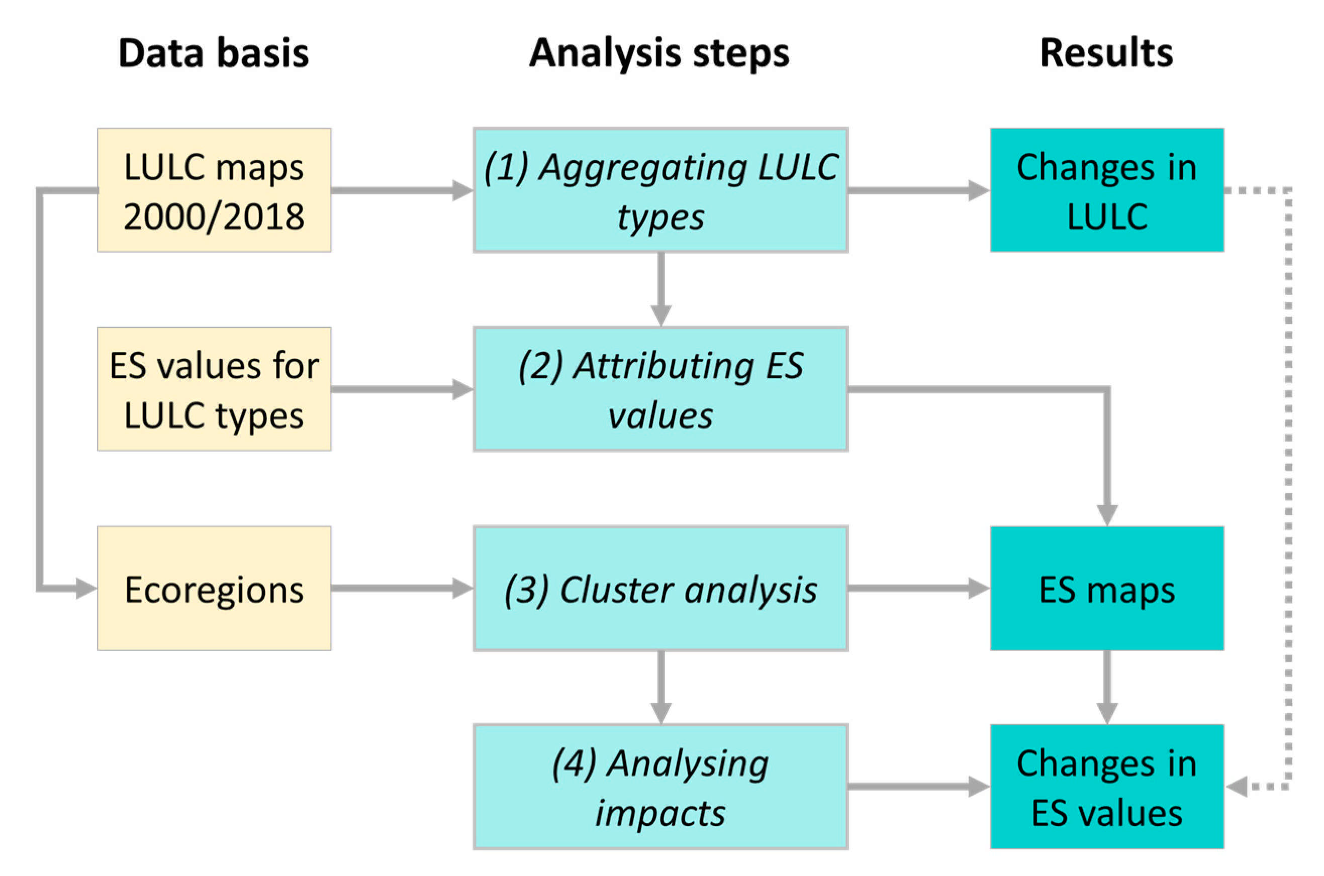
Figure 1. Steps for analysing trends in ES values across Europe at the level of ecoregions (authors’ own elaboration).
Sustainability 13 07095 g001
Figure 2. ES values regarding the three ES categories in 2018 (above) and changes between 2000 and 2018 (below) for ecoregions across Europe. For individual ES, see Figure A2 (authors own elaboration).
Sustainability 13 07095 g002
Figure 3. Groups of ecoregions as a result of hierarchical cluster analysis (left), based on current LULC distribution and LULC changes between 2000 and 2018 (middle) and related ES values and changes between 2000 and 2018 (right). Provisioning ES: pasture and fodder production (P1), agricultural food production (P2), timber production (P3), gathering mushrooms and wild berries (P4), provision of clean drinking water (P5); regulating ES: protection from hazards (R1), prevention of water scarcity (R2), provision of habitats (R3), maintaining biodiversity (R4), providing habitats for pollinating insects (R5), pest control (R6), disease control (R7), maintenance or increase of soil fertility (R8), positive effect on the climate (R9); cultural ES: opportunities for leisure activities (C1), attractive housing and living space (C2), experience of animals & plants (C3), aesthetic inspiration (C4), cultural heritage (C5). Authors’ own elaboration.
Sustainability 13 07095 g003
Figure 4. Changes in ES values between 2000 and 2018 for six groups of ecoregions: (G1) near-natural grassland region, (G2) forest-dominated region, (G3) region with agricultural mixed systems, (G4) crop-dominated region, (G5) wetland-dominated region, and (G6) intensively-used steppic regions. Circles indicate outliers and stars represent single values. Authors’ own elaboration.
Sustainability 13 07095 g004
Publisher’s Note: MDPI stays neutral with regard to jurisdictional claims in published maps and institutional affiliations.