
Patterns and Drivers of Deforestation and Forest Degradation in Myanmar


Abstract
:1. Introduction
2. Material and Methods
2.1. Data Sets and Limitations
2.2. Post Classification Change Detection Analysis
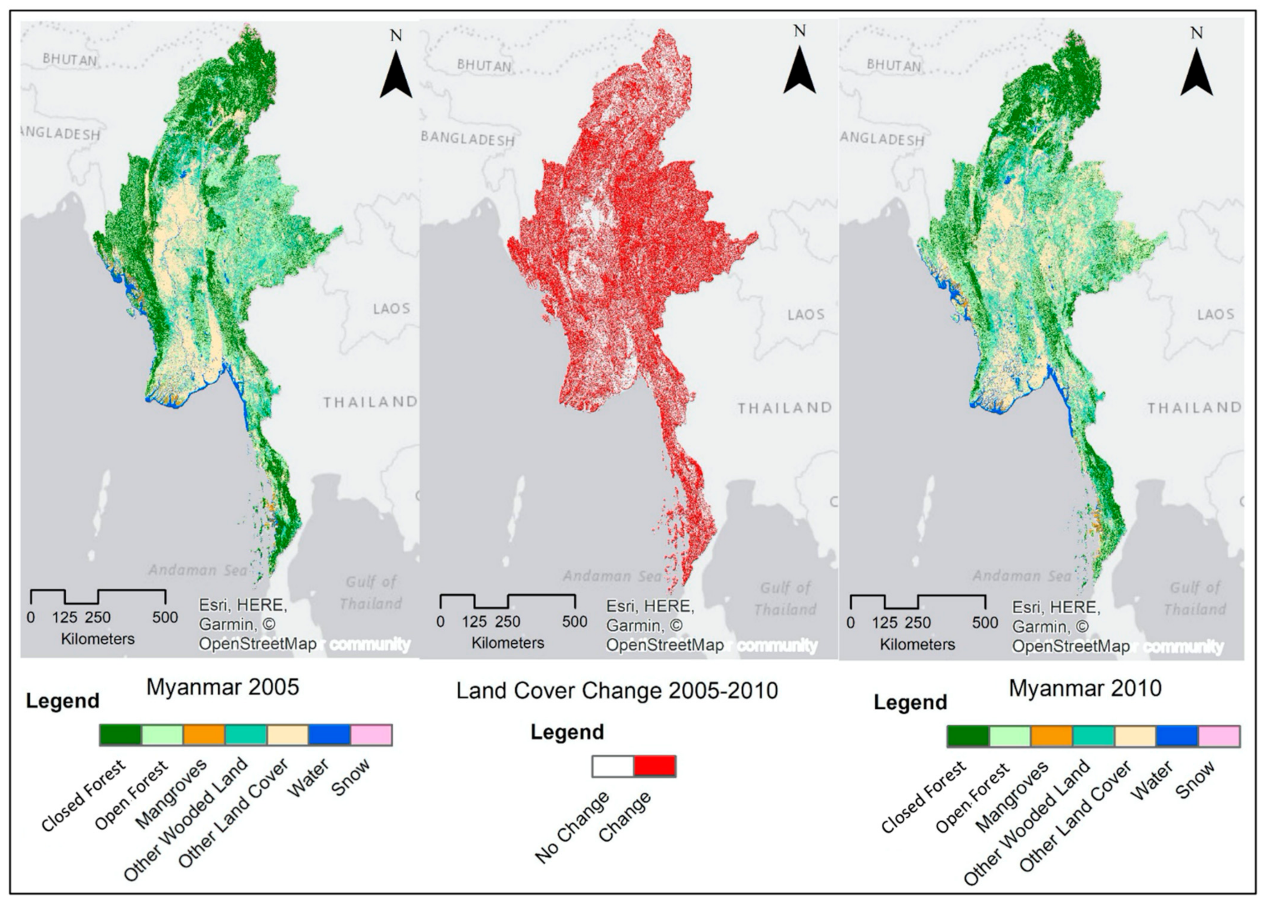
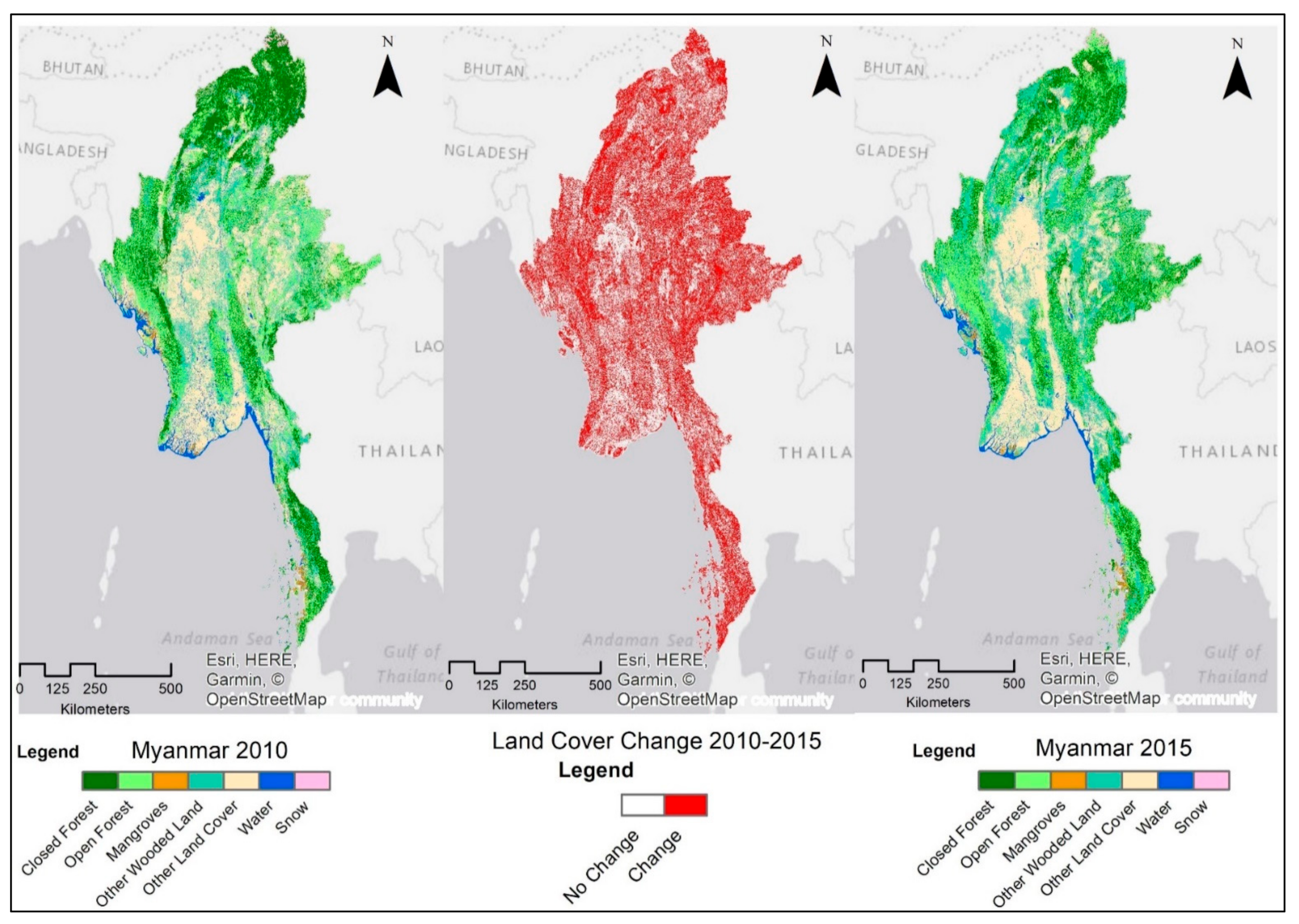
3. Results
3.1. Major Changes in Land Cover
3.2. ‘From-To’ Change Information of Land Cover Classes
3.3. Land Cover Changes by States and Regions
4. Discussion
4.1. Significance
4.2. Drivers of Deforestation and Forest Degradation
4.2.1. Agricultural Expansion
4.2.2. Legal and Illegal Logging
4.2.3. Fuelwood and Charcoal Consumption
4.2.4. Road Construction
4.2.5. Mining Sites and Dam Construction
4.3. Insight into Possible Policy Interventions
5. Conclusions
Author Contributions
Funding
Institutional Review Board Statement
Informed Consent Statement
Conflicts of Interest
Appendix A

Appendix B

| Time 1 | Time 2 | Total Time 1 | Loss | |||
|---|---|---|---|---|---|---|
| Category 1 | Category 2 | Category 3 | Category 4 | |||
| Category 1 | P11 | P12 | P13 | P14 | P1+ | P1+ − P11 |
| Category 2 | P21 | P22 | P23 | P24 | P2+ | P2+ − P22 |
| Category 3 | P31 | P32 | P33 | P34 | P3+ | P3+ − P33 |
| Category 4 | P41 | P42 | P43 | P44 | P4+ | P4+ − P44 |
| Total time 2 | P+1 | P+2 | P+3 | P+4 | ||
| Gain | P1+ − P11 | P2+ − P22 | P3+ − P33 | P4+ − P44 | 1 |
Appendix C
| LC Classes | 2005 Area(Mha) | 2010 Area(Mha) | 2015 Area(Mha) | 2005–2010, Change Rate (r,%/year) | 2010–2015, Change Rate (r,%/year) | 2005–2015, Change Rate (r,%/year) |
|---|---|---|---|---|---|---|
| Closed Forest | 19.6 | 14.9 | 12.5 | −5.44 | −3.54 | −4.49 |
| Open Forest | 15.9 | 16.3 | 17.2 | 0.45 | 1.12 | 0.79 |
| Total Forest | 35.5 | 31.2 | 29.7 | −2.58 | −0.97 | −1.78 |
| Mangroves | 0.52 | 0.51 | 0.48 | −0.19 | −1.58 | −0.89 |
| Other woodland | 12.8 | 14.0 | 18.9 | 1.90 | 5.98 | 3.94 |
| Others | 16.9 | 19.7 | 17.0 | 2.98 | −2.93 | 0.02 |
| Water | 2.1 | 2.7 | 2.0 | 4.60 | −5.89 | −0.65 |
| Snow | 0.3 | 0.1 | 0.1 | −12.95 | −1.31 | −7.13 |
Appendix D
| 2005 | |||||||
|---|---|---|---|---|---|---|---|
| OBJECTID | Value | Count | S/R Code | States and Regions | lulc_2005 | Landcover Classes | Area (ha) |
| 71 | 72 | 2,849,615 | 0 | Ayeyarwady | 1 | Closed Forest | 256,465 |
| 57 | 58 | 4,450,287 | 1 | Bago | 1 | Closed Forest | 400,526 |
| 34 | 35 | 8,030,925 | 2 | Magway | 1 | Closed Forest | 722,783 |
| 30 | 31 | 7,395,045 | 3 | Mandalay | 1 | Closed Forest | 665,554 |
| 44 | 45 | 2,990,963 | 4 | Nay Pyi Taw | 1 | Closed Forest | 269,187 |
| 7 | 8 | 29,796,843 | 5 | Sagaing | 1 | Closed Forest | 2,681,716 |
| 92 | 93 | 21,199,748 | 6 | Tanintharyi | 1 | Closed Forest | 1,907,977 |
| 74 | 75 | 70,378 | 7 | Yangon | 1 | Closed Forest | 6334 |
| 14 | 15 | 22,785,172 | 8 | Chin | 1 | Closed Forest | 2,050,665 |
| 3 | 4 | 57,738,683 | 9 | Kachin | 1 | Closed Forest | 5,196,481 |
| 52 | 53 | 4,010,554 | 10 | Kayah | 1 | Closed Forest | 360,950 |
| 55 | 56 | 9,462,643 | 11 | Kayin | 1 | Closed Forest | 851,638 |
| 78 | 79 | 1,268,680 | 12 | Mon | 1 | Closed Forest | 114,181 |
| 36 | 37 | 20,265,935 | 13 | Rakhine | 1 | Closed Forest | 1,823,934 |
| 23 | 24 | 30,420,311 | 14 | Shan | 1 | Closed Forest | 2,737,828 |
| 70 | 71 | 4,681,542 | 0 | Ayeyarwady | 2 | Open Forest | 421,339 |
| 56 | 57 | 10,481,844 | 1 | Bago | 2 | Open Forest | 943,366 |
| 35 | 36 | 3,991,575 | 2 | Magway | 2 | Open Forest | 359,242 |
| 27 | 28 | 3,125,797 | 3 | Mandalay | 2 | Open Forest | 281,322 |
| 47 | 48 | 1,509,691 | 4 | Nay Pyi Taw | 2 | Open Forest | 135,872 |
| 8 | 9 | 20,513,683 | 5 | Sagaing | 2 | Open Forest | 1,846,231 |
| 90 | 91 | 8,063,641 | 6 | Tanintharyi | 2 | Open Forest | 725,728 |
| 73 | 74 | 853,557 | 7 | Yangon | 2 | Open Forest | 76,820 |
| 16 | 17 | 13,643,378 | 8 | Chin | 2 | Open Forest | 1,227,904 |
| 2 | 3 | 18,381,687 | 9 | Kachin | 2 | Open Forest | 1,654,352 |
| 49 | 50 | 4,802,122 | 10 | Kayah | 2 | Open Forest | 432,191 |
| 54 | 55 | 8,465,038 | 11 | Kayin | 2 | Open Forest | 761,853 |
| 80 | 81 | 3,929,632 | 12 | Mon | 2 | Open Forest | 353,667 |
| 37 | 38 | 6,704,367 | 13 | Rakhine | 2 | Open Forest | 603,393 |
| 24 | 25 | 67,685,349 | 14 | Shan | 2 | Open Forest | 6,091,681 |
| 83 | 84 | 1,793,063 | 0 | Ayeyarwady | 3 | Mangroves | 161,376 |
| 66 | 67 | 4476 | 1 | Bago | 3 | Mangroves | 403 |
| 65 | 66 | 1 | 2 | Magway | 3 | Mangroves | 0 |
| 93 | 94 | 1,793,312 | 6 | Tanintharyi | 3 | Mangroves | 161,398 |
| 85 | 86 | 136 | 7 | Yangon | 3 | Mangroves | 12 |
| 43 | 44 | 24 | 8 | Chin | 3 | Mangroves | 2 |
| 88 | 89 | 7942 | 11 | Kayin | 3 | Mangroves | 715 |
| 87 | 88 | 21,742 | 12 | Mon | 3 | Mangroves | 1957 |
| 42 | 43 | 1,723,919 | 13 | Rakhine | 3 | Mangroves | 155,153 |
| 69 | 70 | 6,445,068 | 0 | Ayeyarwady | 4 | Other Woodland | 580,056 |
| 60 | 61 | 7,909,594 | 1 | Bago | 4 | Other Woodland | 711,863 |
| 33 | 34 | 7,913,316 | 2 | Magway | 4 | Other Woodland | 712,198 |
| 29 | 30 | 7,566,108 | 3 | Mandalay | 4 | Other Woodland | 680,950 |
| 45 | 46 | 1,617,997 | 4 | Nay Pyi Taw | 4 | Other Woodland | 145,620 |
| 10 | 11 | 22,045,565 | 5 | Sagaing | 4 | Other Woodland | 1,984,101 |
| 91 | 92 | 6,286,607 | 6 | Tanintharyi | 4 | Other Woodland | 565,795 |
| 75 | 76 | 908,304 | 7 | Yangon | 4 | Other Woodland | 81,747 |
| 15 | 16 | 2,787,315 | 8 | Chin | 4 | Other Woodland | 250,858 |
| 4 | 5 | 6,709,212 | 9 | Kachin | 4 | Other Woodland | 603,829 |
| 50 | 51 | 2,412,120 | 10 | Kayah | 4 | Other Woodland | 217,091 |
| 62 | 63 | 8,389,212 | 11 | Kayin | 4 | Other Woodland | 755,029 |
| 79 | 80 | 3,584,005 | 12 | Mon | 4 | Other Woodland | 322,560 |
| 39 | 40 | 2,806,426 | 13 | Rakhine | 4 | Other Woodland | 252,578 |
| 18 | 19 | 53,940,688 | 14 | Shan | 4 | Other Woodland | 4,854,662 |
| 68 | 69 | 19,718,808 | 0 | Ayeyarwady | 5 | Others | 1,774,693 |
| 58 | 59 | 19,264,392 | 1 | Bago | 5 | Others | 1,733,795 |
| 31 | 32 | 29,342,318 | 2 | Magway | 5 | Others | 2,640,809 |
| 26 | 27 | 15,867,026 | 3 | Mandalay | 5 | Others | 1,428,032 |
| 46 | 47 | 1,673,213 | 4 | Nay Pyi Taw | 5 | Others | 150,589 |
| 9 | 10 | 29,883,632 | 5 | Sagaing | 5 | Others | 2,689,527 |
| 94 | 95 | 6,419,928 | 6 | Tanintharyi | 5 | Others | 577,794 |
| 76 | 77 | 8,321,388 | 7 | Yangon | 5 | Others | 748,925 |
| 17 | 18 | 823,862 | 8 | Chin | 5 | Others | 74,148 |
| 5 | 6 | 11,939,302 | 9 | Kachin | 5 | Others | 1,074,537 |
| 51 | 52 | 1,730,103 | 10 | Kayah | 5 | Others | 155,709 |
| 61 | 62 | 6,970,502 | 11 | Kayin | 5 | Others | 627,345 |
| 81 | 82 | 3,246,647 | 12 | Mon | 5 | Others | 292,198 |
| 38 | 39 | 6,063,786 | 13 | Rakhine | 5 | Others | 545,741 |
| 19 | 20 | 25,593,693 | 14 | Shan | 5 | Others | 2,303,432 |
| 67 | 68 | 1,947,062 | 0 | Ayeyarwady | 6 | Water | 175,236 |
| 59 | 60 | 1,074,817 | 1 | Bago | 6 | Water | 96,734 |
| 32 | 33 | 749,432 | 2 | Magway | 6 | Water | 67,449 |
| 28 | 29 | 488,812 | 3 | Mandalay | 6 | Water | 43,993 |
| 48 | 49 | 62,363 | 4 | Nay Pyi Taw | 6 | Water | 5613 |
| 12 | 13 | 1,817,717 | 5 | Sagaing | 6 | Water | 163,595 |
| 95 | 96 | 12,73,853 | 6 | Tanintharyi | 6 | Water | 114,647 |
| 77 | 78 | 687,463 | 7 | Yangon | 6 | Water | 61,872 |
| 25 | 26 | 89,657 | 8 | Chin | 6 | Water | 8069 |
| 6 | 7 | 999,059 | 9 | Kachin | 6 | Water | 89,915 |
| 53 | 54 | 99,408 | 10 | Kayah | 6 | Water | 8947 |
| 64 | 65 | 332,219 | 11 | Kayin | 6 | Water | 29,900 |
| 82 | 83 | 435,181 | 12 | Mon | 6 | Water | 39,166 |
| 41 | 42 | 1,303,430 | 13 | Rakhine | 6 | Water | 117,309 |
| 22 | 23 | 578,413 | 14 | Shan | 6 | Water | 52,057 |
| 13 | 14 | 43 | 5 | Sagaing | 7 | Snow | 4 |
| 0 | 1 | 2,968,200 | 9 | Kachin | 7 | Snow | 267,138 |
| 2010 | |||||||
| OBJECTID | Value | Count | S/R Code | States and Regions Name | lulc_2010 | Landcover Classes | Area (ha) |
| 63 | 63 | 1,332,886 | 0 | Ayeyarwady | 1 | Closed Forest | 119,960 |
| 53 | 53 | 4,266,372 | 1 | Bago | 1 | Closed Forest | 383,973 |
| 31 | 31 | 5,961,075 | 2 | Magway | 1 | Closed Forest | 536,497 |
| 26 | 26 | 1,664,572 | 3 | Mandalay | 1 | Closed Forest | 149,811 |
| 41 | 41 | 878,324 | 4 | Nay Pyi Taw | 1 | Closed Forest | 79,049 |
| 9 | 9 | 28,886,100 | 5 | Sagaing | 1 | Closed Forest | 2,599,749 |
| 77 | 77 | 18,090,061 | 6 | Tanintharyi | 1 | Closed Forest | 1,628,105 |
| 66 | 66 | 42,161 | 7 | Yangon | 1 | Closed Forest | 3794 |
| 14 | 14 | 15,333,125 | 8 | Chin | 1 | Closed Forest | 1,379,981 |
| 3 | 3 | 53,042,063 | 9 | Kachin | 1 | Closed Forest | 4,773,786 |
| 45 | 45 | 3,567,534 | 10 | Kayah | 1 | Closed Forest | 321,078 |
| 49 | 49 | 6,541,032 | 11 | Kayin | 1 | Closed Forest | 588,693 |
| 71 | 71 | 1,258,086 | 12 | Mon | 1 | Closed Forest | 113,228 |
| 35 | 35 | 5,567,455 | 13 | Rakhine | 1 | Closed Forest | 501,071 |
| 21 | 21 | 27,846,211 | 14 | Shan | 1 | Closed Forest | 2,506,159 |
| 62 | 62 | 3,402,949 | 0 | Ayeyarwady | 2 | Open Forest | 306,265 |
| 55 | 55 | 9,644,275 | 1 | Bago | 2 | Open Forest | 867,985 |
| 29 | 29 | 3,084,448 | 2 | Magway | 2 | Open Forest | 277,600 |
| 23 | 23 | 6,655,135 | 3 | Mandalay | 2 | Open Forest | 598,962 |
| 39 | 39 | 2,943,761 | 4 | Nay Pyi Taw | 2 | Open Forest | 264,938 |
| 8 | 8 | 19,748,783 | 5 | Sagaing | 2 | Open Forest | 1,777,390 |
| 78 | 78 | 10,967,154 | 6 | Tanintharyi | 2 | Open Forest | 987,044 |
| 65 | 65 | 578,791 | 7 | Yangon | 2 | Open Forest | 52,091 |
| 12 | 12 | 18,049,813 | 8 | Chin | 2 | Open Forest | 1,624,483 |
| 2 | 2 | 19,955,902 | 9 | Kachin | 2 | Open Forest | 1,796,031 |
| 43 | 43 | 4,515,384 | 10 | Kayah | 2 | Open Forest | 406,385 |
| 48 | 48 | 9,398,729 | 11 | Kayin | 2 | Open Forest | 845,886 |
| 70 | 70 | 2,787,443 | 12 | Mon | 2 | Open Forest | 250,870 |
| 33 | 33 | 15,861,487 | 13 | Rakhine | 2 | Open Forest | 1,427,534 |
| 19 | 19 | 53,208,056 | 14 | Shan | 2 | Open Forest | 4,788,725 |
| 64 | 64 | 768,306 | 0 | Ayeyarwady | 3 | Mangroves | 69,148 |
| 58 | 58 | 832 | 1 | Bago | 3 | Mangroves | 75 |
| 82 | 82 | 2,478,427 | 6 | Tanintharyi | 3 | Mangroves | 223,058 |
| 75 | 75 | 122 | 7 | Yangon | 3 | Mangroves | 11 |
| 76 | 76 | 100,357 | 12 | Mon | 3 | Mangroves | 9032 |
| 37 | 37 | 2,033,575 | 13 | Rakhine | 3 | Mangroves | 183,022 |
| 61 | 61 | 5,231,723 | 0 | Ayeyarwady | 4 | Other woodland | 470,855 |
| 54 | 54 | 11,011,515 | 1 | Bago | 4 | Other woodland | 991,036 |
| 30 | 30 | 13,804,068 | 2 | Magway | 4 | Other woodland | 1,242,366 |
| 25 | 25 | 10,581,621 | 3 | Mandalay | 4 | Other woodland | 952,346 |
| 38 | 38 | 2,201,838 | 4 | Nay Pyi Taw | 4 | Other woodland | 198,165 |
| 10 | 10 | 20,978,780 | 5 | Sagaing | 4 | Other woodland | 1,888,090 |
| 79 | 79 | 8,427,866 | 6 | Tanintharyi | 4 | Other woodland | 758,508 |
| 67 | 67 | 1,987,464 | 7 | Yangon | 4 | Other woodland | 178,872 |
| 16 | 16 | 5,208,367 | 8 | Chin | 4 | Other woodland | 468,753 |
| 5 | 5 | 11,168,970 | 9 | Kachin | 4 | Other woodland | 1,005,207 |
| 44 | 44 | 2,777,141 | 10 | Kayah | 4 | Other woodland | 249,943 |
| 50 | 50 | 9,899,278 | 11 | Kayin | 4 | Other woodland | 890,935 |
| 72 | 72 | 3,080,180 | 12 | Mon | 4 | Other woodland | 277,216 |
| 32 | 32 | 4,767,022 | 13 | Rakhine | 4 | Other woodland | 429,032 |
| 17 | 17 | 44,408,799 | 14 | Shan | 4 | Other woodland | 3,996,792 |
| 60 | 60 | 22,941,569 | 0 | Ayeyarwady | 5 | Other | 2,064,741 |
| 52 | 52 | 16,364,866 | 1 | Bago | 5 | Other | 1,472,838 |
| 27 | 27 | 26,400,477 | 2 | Magway | 5 | Other | 2,376,043 |
| 22 | 22 | 14,915,664 | 3 | Mandalay | 5 | Other | 1,342,410 |
| 40 | 40 | 1,716,664 | 4 | Nay Pyi Taw | 5 | Other | 154,500 |
| 7 | 7 | 30,246,333 | 5 | Sagaing | 5 | Other | 2,722,170 |
| 80 | 80 | 3,953,496 | 6 | Tanintharyi | 5 | Other | 355,815 |
| 68 | 68 | 7,174,867 | 7 | Yangon | 5 | Other | 645,738 |
| 15 | 15 | 1,472,989 | 8 | Chin | 5 | Other | 132,569 |
| 4 | 4 | 11,846,064 | 9 | Kachin | 5 | Other | 1,066,146 |
| 46 | 46 | 2,071,458 | 10 | Kayah | 5 | Other | 186,431 |
| 56 | 56 | 7,379,412 | 11 | Kayin | 5 | Other | 664,147 |
| 73 | 73 | 4,448,497 | 12 | Mon | 5 | Other | 400,365 |
| 34 | 34 | 9,022,149 | 13 | Rakhine | 5 | Other | 811,993 |
| 18 | 18 | 57,693,178 | 14 | Shan | 5 | Other | 5,192,386 |
| 59 | 59 | 3,762,037 | 0 | Ayeyarwady | 6 | Water | 338,583 |
| 51 | 51 | 1,897,550 | 1 | Bago | 6 | Water | 170,780 |
| 28 | 28 | 777,499 | 2 | Magway | 6 | Water | 69,975 |
| 24 | 24 | 625,796 | 3 | Mandalay | 6 | Water | 56,322 |
| 42 | 42 | 113,640 | 4 | Nay Pyi Taw | 6 | Water | 10,228 |
| 11 | 11 | 2,064,772 | 5 | Sagaing | 6 | Water | 185,829 |
| 81 | 81 | 1,267,538 | 6 | Tanintharyi | 6 | Water | 114,078 |
| 69 | 69 | 1,058,383 | 7 | Yangon | 6 | Water | 95,254 |
| 13 | 13 | 80,188 | 8 | Chin | 6 | Water | 7217 |
| 6 | 6 | 1,228,631 | 9 | Kachin | 6 | Water | 110,577 |
| 47 | 47 | 128,115 | 10 | Kayah | 6 | Water | 11,530 |
| 57 | 57 | 435,478 | 11 | Kayin | 6 | Water | 39,193 |
| 74 | 74 | 812,443 | 12 | Mon | 6 | Water | 73,120 |
| 36 | 36 | 1,633,701 | 13 | Rakhine | 6 | Water | 147,033 |
| 20 | 20 | 784,668 | 14 | Shan | 6 | Water | 70,620 |
| 1 | 1 | 1,512,338 | 9 | Kachin | 7 | Snow | 136,110 |
| 2015 | |||||||
| OBJECTID | Value | Count | S/R Code | States and Regions Name | lulc_2015 | Landcover Classes | Area (ha) |
| 59 | 59 | 972,753 | 0 | Ayeyarwady | 1 | Closed Forest | 87,548 |
| 52 | 52 | 4,974,478 | 1 | Bago | 1 | Closed Forest | 447,703 |
| 31 | 31 | 1,877,276 | 2 | Magway | 1 | Closed Forest | 168,955 |
| 25 | 25 | 2,481,660 | 3 | Mandalay | 1 | Closed Forest | 223,349 |
| 40 | 40 | 1,149,253 | 4 | Nay Pyi Taw | 1 | Closed Forest | 103,433 |
| 7 | 7 | 18,196,614 | 5 | Sagaing | 1 | Closed Forest | 1,637,695 |
| 77 | 77 | 11,907,205 | 6 | Tanintharyi | 1 | Closed Forest | 1,071,648 |
| 64 | 64 | 113,456 | 7 | Yangon | 1 | Closed Forest | 10,211 |
| 13 | 13 | 8,716,851 | 8 | Chin | 1 | Closed Forest | 784,517 |
| 5 | 5 | 36,020,720 | 9 | Kachin | 1 | Closed Forest | 3,241,865 |
| 45 | 45 | 2,324,750 | 10 | Kayah | 1 | Closed Forest | 209,228 |
| 50 | 50 | 6,120,824 | 11 | Kayin | 1 | Closed Forest | 550,874 |
| 68 | 68 | 1,404,163 | 12 | Mon | 1 | Closed Forest | 126,375 |
| 34 | 34 | 6,641,887 | 13 | Rakhine | 1 | Closed Forest | 597,770 |
| 20 | 20 | 26,804,356 | 14 | Shan | 1 | Closed Forest | 2,412,392 |
| 61 | 61 | 2,499,982 | 0 | Ayeyarwady | 2 | Open Forest | 224,998 |
| 53 | 53 | 9,912,396 | 1 | Bago | 2 | Open Forest | 892,116 |
| 30 | 30 | 5,835,882 | 2 | Magway | 2 | Open Forest | 525,229 |
| 26 | 26 | 3,649,866 | 3 | Mandalay | 2 | Open Forest | 328,488 |
| 38 | 38 | 2,484,875 | 4 | Nay Pyi Taw | 2 | Open Forest | 223,639 |
| 8 | 8 | 19,720,130 | 5 | Sagaing | 2 | Open Forest | 1,774,812 |
| 78 | 78 | 17,464,240 | 6 | Tanintharyi | 2 | Open Forest | 1,571,782 |
| 63 | 63 | 820,789 | 7 | Yangon | 2 | Open Forest | 73,871 |
| 12 | 12 | 18,988,795 | 8 | Chin | 2 | Open Forest | 1,708,992 |
| 2 | 2 | 34,543,214 | 9 | Kachin | 2 | Open Forest | 3,108,889 |
| 44 | 44 | 4,054,996 | 10 | Kayah | 2 | Open Forest | 364,950 |
| 49 | 49 | 8,892,058 | 11 | Kayin | 2 | Open Forest | 800,285 |
| 67 | 67 | 1,513,525 | 12 | Mon | 2 | Open Forest | 136,217 |
| 32 | 32 | 13,457,679 | 13 | Rakhine | 2 | Open Forest | 1,211,191 |
| 18 | 18 | 47,466,537 | 14 | Shan | 2 | Open Forest | 4,271,988 |
| 73 | 73 | 855,940 | 0 | Ayeyarwady | 3 | Mangroves | 77,035 |
| 74 | 74 | 7770 | 1 | Bago | 3 | Mangroves | 699 |
| 82 | 82 | 2,770,394 | 6 | Tanintharyi | 3 | Mangroves | 249,335 |
| 75 | 75 | 18,145 | 7 | Yangon | 3 | Mangroves | 1633 |
| 76 | 76 | 35,233 | 12 | Mon | 3 | Mangroves | 3171 |
| 37 | 37 | 1,350,131 | 13 | Rakhine | 3 | Mangroves | 121,512 |
| 58 | 58 | 8,562,428 | 0 | Ayeyarwady | 4 | Other woodland | 770,619 |
| 51 | 51 | 10,780,958 | 1 | Bago | 4 | Other woodland | 970,286 |
| 29 | 29 | 19,743,112 | 2 | Magway | 4 | Other woodland | 1,776,880 |
| 24 | 24 | 8,819,073 | 3 | Mandalay | 4 | Other woodland | 793,717 |
| 39 | 39 | 1,305,735 | 4 | Nay Pyi Taw | 4 | Other woodland | 117,516 |
| 9 | 9 | 34,043,519 | 5 | Sagaing | 4 | Other woodland | 3,063,917 |
| 79 | 79 | 10,631,664 | 6 | Tanintharyi | 4 | Other woodland | 956,850 |
| 65 | 65 | 2,295,712 | 7 | Yangon | 4 | Other woodland | 206,614 |
| 14 | 14 | 11,538,669 | 8 | Chin | 4 | Other woodland | 1,038,480 |
| 3 | 3 | 16,915,581 | 9 | Kachin | 4 | Other woodland | 1,522,402 |
| 43 | 43 | 4,720,950 | 10 | Kayah | 4 | Other woodland | 424,886 |
| 48 | 48 | 12,472,099 | 11 | Kayin | 4 | Other woodland | 1,122,489 |
| 69 | 69 | 4,508,120 | 12 | Mon | 4 | Other woodland | 405,731 |
| 33 | 33 | 9,112,832 | 13 | Rakhine | 4 | Other woodland | 820,155 |
| 17 | 17 | 54,390,820 | 14 | Shan | 4 | Other woodland | 4,895,174 |
| 62 | 62 | 23,361,579 | 0 | Ayeyarwady | 5 | Other | 2,102,542 |
| 54 | 54 | 15,951,025 | 1 | Bago | 5 | Other | 1,435,592 |
| 28 | 28 | 21,922,752 | 2 | Magway | 5 | Other | 1,973,048 |
| 22 | 22 | 18,987,355 | 3 | Mandalay | 5 | Other | 1,708,862 |
| 41 | 41 | 2,853,881 | 4 | Nay Pyi Taw | 5 | Other | 256,849 |
| 10 | 10 | 30,958,708 | 5 | Sagaing | 5 | Other | 2,786,284 |
| 80 | 80 | 1,750,640 | 6 | Tanintharyi | 5 | Other | 157,558 |
| 71 | 71 | 7,151,858 | 7 | Yangon | 5 | Other | 643,667 |
| 21 | 21 | 852,339 | 8 | Chin | 5 | Other | 76,711 |
| 6 | 6 | 9,145,899 | 9 | Kachin | 5 | Other | 823,131 |
| 46 | 46 | 1,900,298 | 10 | Kayah | 5 | Other | 171,027 |
| 56 | 56 | 5,910,405 | 11 | Kayin | 5 | Other | 531,936 |
| 70 | 70 | 4,837,231 | 12 | Mon | 5 | Other | 435,351 |
| 35 | 35 | 7,298,823 | 13 | Rakhine | 5 | Other | 656,894 |
| 16 | 16 | 34,460,851 | 14 | Shan | 5 | Other | 3,101,477 |
| 60 | 60 | 1,186,892 | 0 | Ayeyarwady | 6 | Water | 106,820 |
| 55 | 55 | 1,558,783 | 1 | Bago | 6 | Water | 140,290 |
| 27 | 27 | 648,545 | 2 | Magway | 6 | Water | 58,369 |
| 23 | 23 | 504,834 | 3 | Mandalay | 6 | Water | 45,435 |
| 42 | 42 | 60,483 | 4 | Nay Pyi Taw | 6 | Water | 5443 |
| 11 | 11 | 123,7181 | 5 | Sagaing | 6 | Water | 111,346 |
| 81 | 81 | 720,354 | 6 | Tanintharyi | 6 | Water | 64,832 |
| 66 | 66 | 441,895 | 7 | Yangon | 6 | Water | 39,771 |
| 15 | 15 | 51,977 | 8 | Chin | 6 | Water | 4678 |
| 4 | 4 | 705,569 | 9 | Kachin | 6 | Water | 63,501 |
| 47 | 47 | 58,984 | 10 | Kayah | 6 | Water | 5309 |
| 57 | 57 | 262,758 | 11 | Kayin | 6 | Water | 23,648 |
| 72 | 72 | 188,762 | 12 | Mon | 6 | Water | 16,989 |
| 36 | 36 | 1,024,632 | 13 | Rakhine | 6 | Water | 92,217 |
| 19 | 19 | 824,693 | 14 | Shan | 6 | Water | 74,222 |
| 1 | 1 | 1,428,849 | 9 | Kachin | 7 | Snow | 128,596 |
References
- MOECAF. Fifth National Report to the Convention on Biological Diversity; Ministry of Environmental Conservation and Forestry (MOECAF): Naypyitaw, Myanmar, 2014.
- IUCN. Myanmar; IUCN: Gland, Switzerland, 2018. [Google Scholar]
- World Bank. Myanmar’s Country Profile; World Bank: Washington, DC, USA, 2018. [Google Scholar]
- Hughes, A.C. Understanding the drivers of Southeast Asian biodiversity loss. Ecosphere 2017, 8, e01624. [Google Scholar] [CrossRef]
- Yang, R.; Luo, Y.; Yang, K.; Hong, L.; Zhou, X. Analysis of Forest Deforestation and its Driving Factors in Myanmar from 1988 to 2017. Sustainability 2019, 11, 3047. [Google Scholar] [CrossRef] [Green Version]
- Sexton, J.O.; Noojipady, P.; Song, X.P.; Feng, M.; Song, D.X.; Kim, D.H.; Anand, A.; Huang, C.; Channan, S.; Pimm, S.L.; et al. Conservation policy and the measurement of forests. Nat. Clim. Chang. 2016, 6, 192–196. [Google Scholar] [CrossRef]
- FAO. Country Report: Myanmar, Global Forest Resources Assessment 2020; Food and Agriculture Organisation: Rome, Italy, 2020; Available online: www.fao.org/3/cb0030en/cb0030en.pdf (accessed on 29 June 2021).
- FAO. Global Forest Resources Assessment 2020; Food and Agriculture Organization: Rome, Italy, 2020; Available online: http://www.fao.org/3/ca9825en/ca9825en.pdf (accessed on 29 June 2021).
- Songer, M.; Aung, M.; Senior, B.; DeFries, R.; Leimgruber, P. Spatial and temporal deforestation dynamics in protected and unprotected dry forests: A case study from Myanmar (Burma). Biodivers. Conserv. 2009, 18, 1001–1018. [Google Scholar] [CrossRef]
- Forest Department. National Biodiversity Strategy and Action Plan 2015–2020; Forest Department Myanmar: Naypyitaw, Myanmar, 2014.
- Dong, M.; He, J. Linking the past to the future: A reality check on cross-border timber trade from Myanmar (Burma) to China. For. Policy Econ. 2018, 87, 11–19. [Google Scholar] [CrossRef]
- Aung, T.S.; Fischer, T.B.; Buchanan, J. Land use and land cover changes along the China-Myanmar Oil and Gas pipelines–Monitoring infrastructure development in remote conflict-prone regions. PLoS ONE 2020, 15, e0237806. [Google Scholar] [CrossRef]
- Lim, C.L.; Prescott, G.W.; Alban, J.D.T.; Ziegler, A.D.; Webb, E.L. Untangling the proximate causes and underlying drivers of deforestation and forest degradation in Myanmar. Conserv. Biol. 2017, 31, 1362–1372. [Google Scholar] [CrossRef] [PubMed] [Green Version]
- Mon, M.S.; Kajisa, T.; Mizoue, N.; Yoshida, S. Monitoring deforestation and forest degradation in the Bago Mountain Area, Myanmar using FCD Mapper. J. For. Plan. 2010, 15, 63–72. [Google Scholar] [CrossRef]
- Pasha, S.; Satish, K.; Unnikrishnan, A.; Chavan, S.; Jha, C.; Diwakar, P.; Dadhwal, V. Quantifying and predicting multi-decadal forest cover changes in Myanmar: A biodiversity hotspot under threat. Biodivers. Conserv. 2019, 28, 1129–1149. [Google Scholar] [CrossRef]
- Prescott, G.W.; Sutherland, W.J.; Aguirre, D.; Baird, M.; Bowman, V.; Brunner, J.; Connette, G.M.; Cosier, M.; Dapice, D.; De Alban, J.D.; et al. Political transition and emergent forest-conservation issues in Myanmar. Conserv. Biol. 2017, 31, 1257–1270. [Google Scholar] [CrossRef]
- Zhang, Y.; Prescott, G.W.; Tay, R.E.; Dickens, B.L.; Webb, E.L.; Htun, S.; Tizard, R.J.; Rao, M.; Carrasco, L.R. Dramatic cropland expansion in Myanmar following political reforms threatens biodiversity. Sci. Rep. 2018, 8, 1–10. [Google Scholar] [CrossRef]
- Webb, E.L.; Jachowski, N.R.A.; Phelps, J.; Friess, D.A.; Than, M.M.; Ziegler, A.D. Deforestation in the Ayeyarwady Delta and the conservation implications of an internationally-engaged Myanmar. Glob. Environ. Chang. 2014, 24, 321–333. [Google Scholar] [CrossRef]
- FREL. Forest Reference Emission Level (FREL) of Myanmar; Ministry of Natural Resources and Environmental Conservation (MONREC): Naypyitaw, Myanmar, 2018.
- Htun, N.; Mizoue, N.; Yoshida, S. Changes in determinants of deforestation and forest degradation in Popa Mountain Park, Central Myanmar. Environ. Manag. 2013, 51, 423–434. [Google Scholar] [CrossRef]
- Leimgruber, P.; Kelly, D.S.; Steininger, M.K.; Brunner, J.; Mueller, T.; Songer, M. Forest cover change patterns in Myanmar (Burma) 1990-2000. Environ. Conserv. 2005, 32, 356–364. [Google Scholar] [CrossRef] [Green Version]
- Liu, F.J.; Huang, C.; Pang, Y.; Li, M.; Song, D.X.; Song, X.P.; Channan, S.; Sexton, J.O.; Jiang, D.; Zhang, P.; et al. Assessment of the three factors affecting Myanmar’s forest cover change using Landsat and MODIS vegetation continuous fields data. Int. J. Digit. Earth 2016, 9, 562–585. [Google Scholar] [CrossRef]
- Mon, M.S.; Mizoue, N.; Htun, N.Z.; Kajisa, T.; Yoshida, S. Factors affecting deforestation and forest degradation in selectively logged production forest: A case study in Myanmar. For. Ecol. Manag. 2011, 267, 35–57. [Google Scholar] [CrossRef]
- Shimizu, K.; Ahmed, O.S.; Ponce-Hernandez, R.; Ota, T.; Win, Z.C.; Mizoue, N.; Yoshida, S. Attribution of disturbance agents to forest change using a Landsat Time Series in tropical seasonal forests in the Bago Mountains, Myanmar. Forests 2017, 8, 218. [Google Scholar] [CrossRef]
- Bhagwat, T.; Hess, A.; Horning, N.; Khaing, T.; Thein, Z.M.; Aung, K.M.; Aung, K.H.; Phyo, P.; Tun, Y.L.; Oo, A.H.; et al. Losing a jewel-Rapid declines in Myanmar’s intact forests from 2002–2014. PLoS ONE 2017, 12, e0176364. [Google Scholar] [CrossRef] [PubMed] [Green Version]
- Wang, C.; Myint, S.W. Environmental concerns of deforestation in Myanmar 2001–2010. Remote Sens. 2016, 8, 728. [Google Scholar] [CrossRef] [Green Version]
- Aung, W.Y. Report on Image Classification Process of Forest Cover Assessment for 2015; Malaysian Forest Department: Naypyidaw, Myanmar, 2016.
- FAO. Country Report: Myanmar, Global Forest Resources Assessment 2015; Food and Agriculture Organisation: Rome, Italy, 2014; Available online: http://www.fao.org/3/az283e/az283e.pdf (accessed on 29 June 2021).
- Jensen, J.R. Remote Sensing of the Environment: An Earth Resource Perspective 2/e; Pearson Education India: Delhi, India, 2009; pp. 333–378. [Google Scholar]
- Lu, D.; Mausel, P.; Brondízio, E.; Moran, E. Change detection techniques. Int. J. Remote Sens. 2004, 25, 2365–2401. [Google Scholar] [CrossRef]
- Pontius, R.G.; Shusas, E.; McEachern, M. Detecting important categorical land changes while accounting for persistence. Agric. Ecosyst. Environ. 2004, 101, 251–268. [Google Scholar] [CrossRef]
- Ward, D.; Phinn, S.R.; Murray, A.T. Monitoring growth in rapidly urbanizing areas using remotely sensed data. Prof. Geogr. 2000, 52, 371–386. [Google Scholar] [CrossRef]
- Townshend, J.R.; Narasimhan, R.; Kim, D.; Song, X.P.; Hansen, M.C.; Li, M.; Channan, S. Global characterization and monitoring of forest cover using Landsat Data: Opportunities and challenges. Int. J. Digit. Earth 2012, 5, 45–57. [Google Scholar] [CrossRef] [Green Version]
- Feng, Y.; Lu, D.; Moran, E.F.; Dutra, L.V.; Calvi, M.F.; De Oliveira, M.A.F. Examining spatial distribution and dynamic change of urban land covers in the Brazilian Amazon using multitemporal multi-sensor high spatial resolution satellite imagery. Remote Sens. 2017, 9, 381. [Google Scholar] [CrossRef] [Green Version]
- Im, J.; Rhee, J.; Jensen, J.R.; Hodgson, M.E. An automated binary change detection model using a calibration approach. Remote Sens. Environ. 2007, 106, 89–105. [Google Scholar] [CrossRef]
- Parihar, S.M.; Sarkar, S.; Dutta, A.; Sharma, S.; Dutta, T. Characterizing wetland dynamics: A post-classification change detection analysis of the East Kolkata Wetlands using open source satellite data. Geocarto Int. 2012, 28, 1–15. [Google Scholar] [CrossRef]
- Puyravaud, J.P. Standardizing the calculation of the annual rate of deforestation. For. Ecol. Manag. 2003, 177, 593–596. [Google Scholar] [CrossRef]
- Hussain, M.; Chen, D.M.; Cheng, A.; Wei, H.; Stanley, D. Change detection from remotely sensed images: From pixel-based to object-based approaches. ISPRS J. Photogramm. Remote 2013, 80, 91–106. [Google Scholar] [CrossRef]
- MIMU. Myanmar State and Region Boundaries MIMU v9.2.1; United Nations Office for the Coordination of Humanitarian Affairs: New York, NY, USA, 2020. [Google Scholar]
- Springate-Baginski, O.; Treue, T.; Htun, K. Legally and Illegally Logged Out; University of Copenhagen: Copenhagen, Denmark, 2016; pp. 1–33. [Google Scholar]
- Lambin, E.F.; Turner, B.L.; Geist, H.J.; Agbola, S.B.; Angelsen, A.; Bruce, J.W.; Coomes, O.T.; Dirzo, R.; Fischer, G.; Folke, C. The causes of land-use and land-cover change: Moving beyond the myths. Glob. Environ. Chang. 2001, 11, 261–269. [Google Scholar] [CrossRef]
- Gibbs, H.K.; Ruesch, A.S.; Achard, F.; Clayton, M.K.; Holmgren, P.; Ramankutty, N.; Foley, J.A. Tropical forests were the primary sources of new agricultural land in the 1980s and 1990s. Proc. Natl. Acad. Sci. USA 2010, 107, 16732–16737. [Google Scholar] [CrossRef] [Green Version]
- FAO. What Woodfuels Can Do to Mitigate Climate Change; Food and Agriculture Organisation: Rome, Italy, 2017; Available online: whttp://www.fao.org/3/i1756e/i1756e00.pdf (accessed on 29 June 2021).
- Donald, P.F.; Round, P.D.; Dai, W.; Aung, T.; Grindley, M.; Steinmetz, R.; Shwe, N.M.; Buchanan, G.M. Social reform and a growing crisis for southern Myanmar’s unique forests. Conserv. Biol. 2015, 29, 1485–1488. [Google Scholar] [CrossRef]
- Woods, K. Commercial agriculture expansion in Myanmar: Links to deforestation, conversion timber, and land conflicts. For. Trends 2015, 13, 1–56. [Google Scholar]
- Daniel, R.R.; Daniel, A.F. Rates and drivers of mangrove deforestation in Southeast Asia, 2000–2012. Proc. Natl. Acad. Sci. USA 2016, 113, 344. [Google Scholar] [CrossRef] [Green Version]
- Grundy-War, C.; Wong Siew Yin, E. Geographies of displacement: The Karenni and The Shan across the Myanmar-Thailand border. Singap. J. Trop. Geogr. 2002, 23, 93–122. [Google Scholar] [CrossRef]
- Woods, K. Ceasefire capitalism: Military–private partnerships, resource concessions and military–state building in the Burma–China borderlands. J. Peasant Stud. 2011, 38, 747–770. [Google Scholar] [CrossRef]
- Hla Maung, T.; Kanzaki, M.; Fukushima, M.; Yazar, M. Structure and composition of a teak-bearing forest under the Myanmar selection system: Impacts of logging and bamboo flowering. Southeast Asian Stud. 2007, 45, 303–316. [Google Scholar] [CrossRef]
- Sist, P.; Ferreira, F.N. Sustainability of reduced-impact logging in the Eastern Amazon. For. Ecol. Manag. 2007, 243, 199–209. [Google Scholar] [CrossRef]
- Sist, P.; Mazzei, L.; Blanc, L.; Rutishauser, E. Large trees as key elements of carbon storage and dynamics after selective logging in the Eastern Amazon. For. Ecol. Manag. 2014, 318, 103–109. [Google Scholar] [CrossRef]
- Win, Z.C.; Mizoue, N.; Ota, T.; Kajisa, T.; Yoshida, S.; Oo, T.N.; Ma, H.O. Differences in consumption rates and patterns between firewood and charcoal: A case study in a rural area of Yedashe Township, Myanmar. Biomass Bioenergy 2018, 109, 39–46. [Google Scholar] [CrossRef]
- Khai, T.C.; Mizoue, N.; Kajisa, T.; Ota, T.; Yoshida, S. Stand structure, composition and illegal logging in selectively logged production forests of Myanmar: Comparison of two compartments subject to different cutting frequency. Glob. Ecol. Conserv. 2016, 7, 132–140. [Google Scholar] [CrossRef] [Green Version]
- Rosy Ne, W.; Suzuki, R.; Takeda, S. Forest cover changes under selective logging in the Kabaung Reserved Forest, Bago Mountains, Myanmar. Mt. Res. Dev. 2009, 29, 328–338. [Google Scholar] [CrossRef]
- Springate-Baginski, O.; Thein, A.K.; Neilm, A.; Thu, W.M.; Doherty, F. Democratising timber: An assessment of Myanmar’s emerging ‘Forest Law Enforcement, Governance and Trade’ (FLEGT) process. For. Policy Econ. 2014, 48, 33–45. [Google Scholar] [CrossRef]
- Laurance, W.F.; Goosem, M.; Laurance, S.G. Impacts of roads and linear clearings on tropical forests. Trends Ecol. Evol. 2009, 24, 659–669. [Google Scholar] [CrossRef]
- EIA. Data Corruption: Exposing the True Scale of Logging in Myanmar. Environment Investigation. Available online: https://www.business-humanrights.org/en/pdf-data-corruption-exposing-the-true-scale-of-logging-in-myanmar (accessed on 10 January 2020).
- ITTO. Tropical Timber Market Report; International Tropical Timber Organisation: Yokohama, Japan, 2017. [Google Scholar]
- EIA. Organised Chaos: The Illicit Overland Timber Trade between Myanmar and China. Available online: https://eia-international.org/report/organised-chaos-the-illicit-overland-timber-trade-between-myanmar-and-china/ (accessed on 10 January 2020).
- DOP. The 2014 Myanmar Population and Housing Census. 2A; Department of Population, Ministry of Immigration and Population: Nay Pyi Taw, Myanmar, 2015.
- Chidumayo, E.N.; Gumbo, D.J. The environmental impacts of charcoal production in tropical ecosystems of the world: A synthesis. Energy Sustain. Dev. 2012, 17, 86–94. [Google Scholar] [CrossRef]
- Bensch, G.; Peters, J. Alleviating deforestation pressures? Impacts of improved stove dissemination on charcoal consumption in urban Senegal. Land Econ. 2013, 89, 676–698. [Google Scholar] [CrossRef]
- Top, N.; Mizoue, N.; Ito, S.; Kai, S.; Nakao, T.; Ty, S. Re-assessment of woodfuel supply and demand relationships in Kampong Thom Province, Cambodia. Biomass Bioenergy 2006, 30, 134–143. [Google Scholar] [CrossRef]
- Forest Trends. Analysis of the China-Myanmar Timber Trade; Forest Trends: Washington, DC, USA, 2014. [Google Scholar]
- Putz, F.E.; Dykstra, D.P.; Heinrich, R. Why poor logging practices persist in the tropics? Conserv. Biol. 2000, 14, 951–956. [Google Scholar] [CrossRef]
- Gregory, P.A.; Eben, N.B.; Paulo, J.C.O.; Michael, K.; David, E.K.; José, N.M.S. Condition and fate of logged forests in the Brazilian Amazon. Proc. Natl. Acad. Sci. USA 2006, 103, 129–147. [Google Scholar] [CrossRef] [Green Version]
- Win, Z.C.; Mizoue, N.; Ota, T.; Wang, G.; Innes, J.L.; Kajisa, T.; Yoshida, S. Spatial and temporal patterns of illegal logging in selectively logged production forest: A case study in Yedashe, Myanmar. J. For. Plan. 2018, 23, 15–25. [Google Scholar] [CrossRef]
- Allen, J.C.; Barnes, D.F. The causes of deforestation in developing countries. Ann. Assoc. Am. Geogr. 1985, 75, 163–184. [Google Scholar] [CrossRef]
- Lambin, E.F.; Geist, H.J.; Lepers, E. Dynamics of Land-Use and Land-Cover Change in Tropical Regions. Annu. Rev. Environ. Resour. 2003, 28, 205–241. [Google Scholar] [CrossRef] [Green Version]
- Laurance, W.; Balmford, A. A global map for road building. Nature 2013, 495, 308–309. [Google Scholar] [CrossRef]
- Pfaff, A.; Robalino, J.; Walker, R.; Aldrich, S.; Caldas, M.; Reis, E.; Perz, S.; Bohrer, C.; Arima, E.; Laurance, W.; et al. Road investments, spatial spillovers, and deforestation in the Brazilian Amazon. J. Reg. Sci. 2007, 47, 109–123. [Google Scholar] [CrossRef] [Green Version]
- Wilkie, D.; Shaw, E.; Rotberg, F.; Morelli, G. Auzel, Roads, Development, and Conservation in the Congo Basin. Conserv. Biol. 2000, 14, 1614–1622. [Google Scholar] [CrossRef]
- Nepstad, D.; Schwartzman, S.; Bamberger, B.; Santilli, M.; Ray, D.; Schlesinger, P.; Rolla, A. Inhibition of Amazon deforestation and fire by parks and indigenous lands. Conserv. Biol. 2006, 20, 65–73. [Google Scholar] [CrossRef]
- IUCN. Protected Planet Report 2016; International Union for Conservation of Nature: Gland, Switzerland, 2016. [Google Scholar]
- Gardiner, N.J.; Robb, L.J.; Searle, M.P. The metallogenic provinces of Myanmar. Appl. Earth Sci. 2014, 123, 25–38. [Google Scholar] [CrossRef]
- Connette, K.; Connette, G.; Bernd, A.; Phyo, P.; Aung, K.; Tun, Y.; Songer, M. Assessment of mining extent and expansion in Myanmar based on freely-available satellite imagery. Remote Sens. 2016, 8, 912. [Google Scholar] [CrossRef] [Green Version]
- Takahito, O.; Yuichi, H.; Osawa, T.; Hatsukawa, Y. Artisanal and small-scale gold mining in Myanmar. Int. J. Hum. Cult. Stud. 2015, 25, 221–230. [Google Scholar] [CrossRef] [Green Version]
- Sarah, P.; Madhu, R.; Myint, O.; Kyaw Thinn, L.; Robert, T.; Thomas, P.; Carrasco, L.R. The impact of gold mining and agricultural concessions on the tree cover and local communities in northern Myanmar. Sci. Rep. 2017, 7, 45–60. [Google Scholar] [CrossRef] [Green Version]
- Jiang, X.; Lu, D.; Moran, E.; Calvi, M.F.; Dutra, L.V.; Li, G. Examining impacts of the Belo Monte hydroelectric dam construction on land-cover changes using multitemporal Landsat imagery. Appl. Geogr. 2018, 97, 35–47. [Google Scholar] [CrossRef]
- Wang, C.; Wang, F.; Wang, Q.; Yang, D.; Li, L.; Zhang, X. Preparing for Myanmar’s environment-friendly reform. Environ. Sci. Policy 2013, 25, 229–233. [Google Scholar] [CrossRef]
- Chen, G.; Powers, R.P.; de Carvalho, L.M.T.; Mora, B. Spatiotemporal patterns of tropical deforestation and forest degradation in response to the operation of the Tucuruí hydroelectric dam in the Amazon basin. Appl. Geogr. 2015, 63, 1–8. [Google Scholar] [CrossRef]
- Lees, A.; Peres, C.; Fearnside, P.; Schneider, M.; Zuanon, J. Hydropower and the future of Amazonian biodiversity. Biodivers. Conserv. 2016, 25, 451–466. [Google Scholar] [CrossRef]
- Scharlemann, J.P.; Kapos, V.; Campbell, A.; Lysenko, I.; Burgess, N.D.; Hansen, M.C.; Gibbs, H.K.; Dickson, B.; Miles, L. Securing tropical forest carbon: The contribution of protected areas to REDD. Oryx 2010, 44, 352–357. [Google Scholar] [CrossRef] [Green Version]
- Aung, M. Policy and practice in Myanmar’s protected area system. J. Environ. Manag. 2007, 84, 188–203. [Google Scholar] [CrossRef]
- UNEP. Protected Area Profile for Myanmar. World Database of Protected Areas; United Nations Environment Program: Nairobi, Kenya, 2018. [Google Scholar]
- Cook, C.N.; Valkan, R.S.; Mascia, M.B.; McGeoch, M.A. Quantifying the extent of protected-area downgrading, downsizing, and degazettement in Australia. Conserv. Biol. 2017, 31, 1039–1052. [Google Scholar] [CrossRef]
- Reed, M.S. Stakeholder participation for environmental management: A literature review. Biol. Conserv. 2008, 141, 2417–2431. [Google Scholar] [CrossRef]
- Rasmussen, L.V.; Watkins, C.; Agrawal, A. Forest contributions to livelihoods in changing agriculture-forest landscapes. For. Policy Econ. 2017, 84, 1–8. [Google Scholar] [CrossRef]
- Bryant, R.L. The Rise and Fall of Taungya Forestry: Social Forestry in Defence of the Empire; Ecologist; International Centre for Research in Agroforestry (ICRAF): Nairobi, Kenya, 1994. [Google Scholar]
- Feurer, M.; Gritten, D.; Than, M.M. Community forestry for livelihoods: Benefiting from Myanmar’s mangroves. Forests 2018, 9, 150. [Google Scholar] [CrossRef] [Green Version]
- James, A.F. Private protected areas in Australia: Current status and future directions. Nat. Conserv. 2015, 10, 1–23. [Google Scholar] [CrossRef] [Green Version]
- Lin, H. Community forestry initiatives in Myanmar: An analysis from a social perspective. Int. For. Rev. 2004, 6, 79–88. [Google Scholar] [CrossRef]


| Landcover Class | Descriptions |
|---|---|
| Closed Forest | Under forestry or no land use, spanning more than 0.5 hectares; with trees higher than 5 m and a canopy cover of more than 40 percent, or trees able to reach these thresholds in situ. |
| Open Forest | Under forestry or no land use, spanning more than 0.5 hectares; with trees higher than 5 m and a canopy cover between 10 and 40 percent, or trees able to reach these thresholds in situ. |
| Mangrove | Area covered by Mangrove tree species as interpreted from satellite imagery and aerial photographs. |
| Other wooded land | Areas mostly covered by grassland and stunted trees, shrub forests, lower that 10% crown density. |
| Other | All land that is not classified as the above classes (e.g., agricultural land, settlement areas, rock, bareland, sandbanks). |
| Water | Inland water bodies, lakes, reservoirs, large streams and rivers. |
| Snow | Snow cover in mountainous areas. |
Publisher’s Note: MDPI stays neutral with regard to jurisdictional claims in published maps and institutional affiliations. |
© 2021 by the authors. Licensee MDPI, Basel, Switzerland. This article is an open access article distributed under the terms and conditions of the Creative Commons Attribution (CC BY) license (https://creativecommons.org/licenses/by/4.0/).
Share and Cite
Naing Tun, Z.; Dargusch, P.; McMoran, D.; McAlpine, C.; Hill, G. Patterns and Drivers of Deforestation and Forest Degradation in Myanmar. Sustainability 2021, 13, 7539. https://doi.org/10.3390/su13147539
Naing Tun Z, Dargusch P, McMoran D, McAlpine C, Hill G. Patterns and Drivers of Deforestation and Forest Degradation in Myanmar. Sustainability. 2021; 13(14):7539. https://doi.org/10.3390/su13147539
Chicago/Turabian StyleNaing Tun, Zaw, Paul Dargusch, DJ McMoran, Clive McAlpine, and Genia Hill. 2021. "Patterns and Drivers of Deforestation and Forest Degradation in Myanmar" Sustainability 13, no. 14: 7539. https://doi.org/10.3390/su13147539
APA StyleNaing Tun, Z., Dargusch, P., McMoran, D., McAlpine, C., & Hill, G. (2021). Patterns and Drivers of Deforestation and Forest Degradation in Myanmar. Sustainability, 13(14), 7539. https://doi.org/10.3390/su13147539