
Open and Consistent Geospatial Data on Population Density, Built-Up and Settlements to Analyse Human Presence, Societal Impact and Sustainability: A Review of GHSL Applications


Abstract
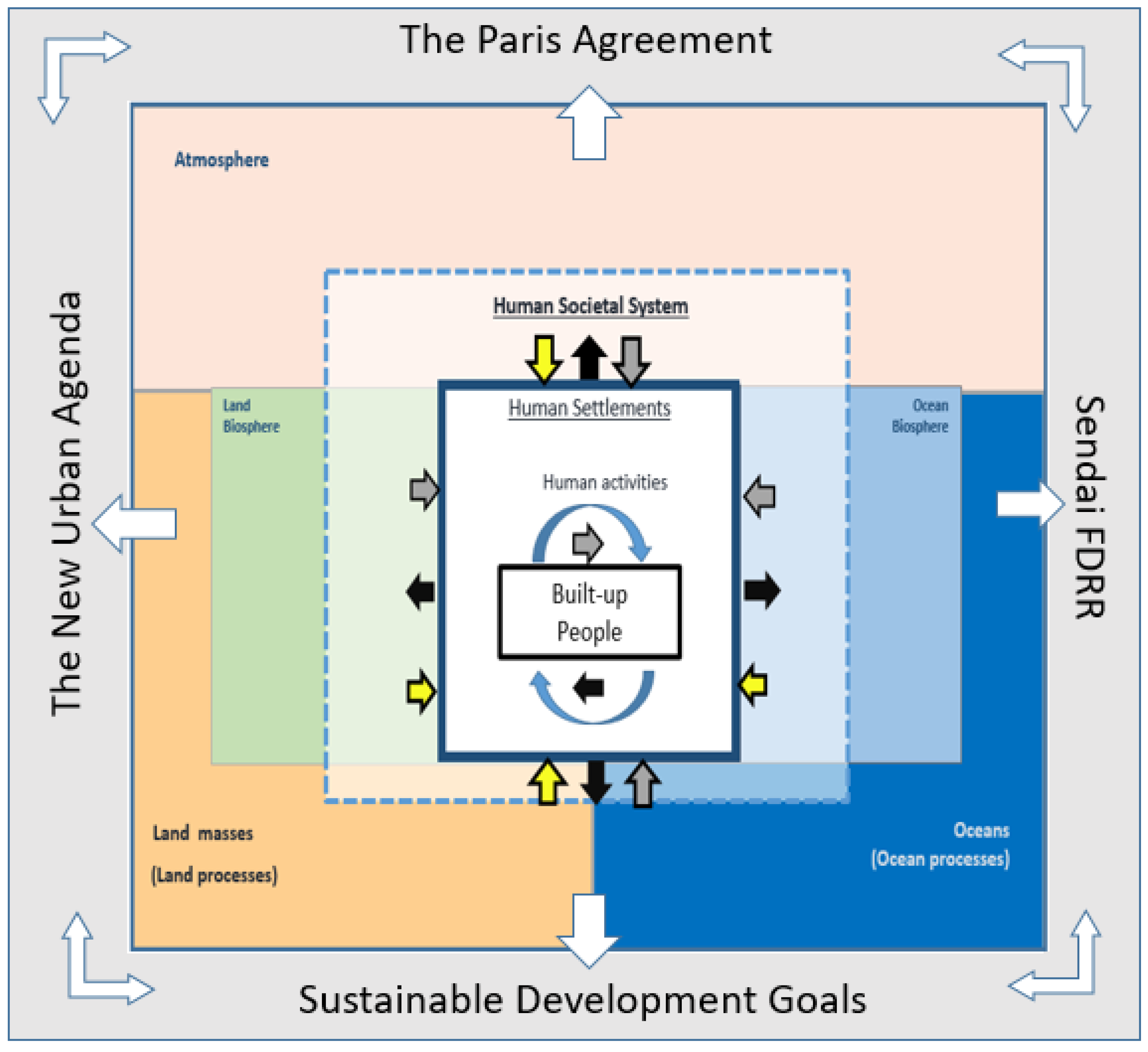
:1. Introduction
2. Background
3. Results
3.1. Human Presence
3.1.1. Sizing Cities and Settlements
3.1.2. Assessing Settlements within Their Perimeter
3.2. Settlement Spatial Growth and Impact
3.3. Settlement Societal Impact
3.4. Hazard Impact
3.5. Development and International Framework Indicators
4. Discussion
5. Conclusions
Supplementary Materials
Author Contributions
Funding
Acknowledgments
Conflicts of Interest
References
- Folke, C.; Polasky, S.; Rockström, J.; Galaz, V.; Westley, F.; Lamont, M.; Scheffer, M.; Österblom, H.; Carpenter, S.R.; Chapin, F.S.; et al. Our future in the Anthropocene biosphere. Ambio 2021, 50, 834–869. [Google Scholar] [CrossRef]
- Steffen, W.; Crutzen, P.; McNeill, J. The Anthropocene: Are Humans Now Overwhelming the Great Forces of Nature? AMBIO 2007, 36, 614–621. [Google Scholar] [CrossRef]
- Morelli, J. Environmental Sustainability: A Definition for Environmental Professionals. J. Environ. Sustain. 2011, 1, 1–10. [Google Scholar] [CrossRef] [Green Version]
- Griggs, D.; Stafford-Smith, M.; Gaffney, O.; Rockström, J.; Öhman, M.C.; Shyamsundar, P.; Steffen, W.; Glaser, G.; Kanie, N.; Noble, I. Sustainable development goals for people and planet. Nature 2013, 495, 305–307. [Google Scholar] [CrossRef]
- Grimm, N.B.; Faeth, S.H.; Golubiewski, N.E.; Redman, C.L.; Wu, J.; Bai, X.; Briggs, J.M. Global Change and the Ecology of Cities. Science 2008, 319, 756–760. [Google Scholar] [CrossRef] [PubMed] [Green Version]
- Güneralp, B.; Seto, K.C. Can gains in efficiency offset the resource demands and CO2 emissions from constructing and operating the built environment? Appl. Geogr. 2012, 32, 40–50. [Google Scholar] [CrossRef]
- Seto, K.C.; Golden, J.S.; Alberti, M.; Turner, B.L. Sustainability in an urbanizing planet. Proc. Natl. Acad. Sci. USA 2017, 114, 8935–8938. [Google Scholar] [CrossRef] [PubMed] [Green Version]
- Zhang, Q.; Seto, K.C. Mapping urbanization dynamics at regional and global scales using multi-temporal DMSP/OLS nighttime light data. Remote Sens. Environ. 2011, 115, 2320–2329. [Google Scholar] [CrossRef]
- Seto, K.C.; Satterthwaite, D. Interactions between urbanization and global environmental change. Curr. Opin. Environ. Sustain. 2010, 2, 127–128. [Google Scholar] [CrossRef]
- Melchiorri, M.; Florczyk, A.; Freire, S.; Schiavina, M.; Pesaresi, M.; Kemper, T. Unveiling 25 Years of Planetary Urbanization with Remote Sensing: Perspectives from the Global Human Settlement Layer. Remote Sens. 2018, 10, 768. [Google Scholar] [CrossRef] [Green Version]
- Haberl, H.; Wiedenhofer, D.; Karl-Heinz, E.; Christoph, G.; Fridolin, K. The Material Stock–Flow–Service Nexus: A New Approach for Tackling the Decoupling Conundrum. Sustainability 2017, 9, 1049. [Google Scholar] [CrossRef] [Green Version]
- Committee on Pathways to Urban Sustainability: Challenges and Opportunities; Science and Technology for Sustainability Program; Policy and Global Affairs; National Academies of Sciences, Engineering, and Medicine. Pathways to Urban Sustainability: Challenges and Opportunities for the United States; National Academies Press: Washington, DC, USA, 2016; p. 23551. [Google Scholar] [CrossRef] [Green Version]
- World Energy Outlook. 2017. Available online: https://www.iea.org/reports/world-energy-outlook-2017 (accessed on 12 July 2021).
- Fischer-Kowalski, M.; Haberl, H. Sustainable development: Socio-economic metabolism and colonization of nature. Int. Soc. Sci. J. 1998, 50, 573–587. [Google Scholar] [CrossRef]
- Pesaresi, M.; Ehrlich, D.; Caravaggi, I.; Kauffmann, M.; Louvrier, C. Toward Global Automatic Built-Up Area Recognition Using Optical VHR Imagery. IEEE J. Sel. Top. Appl. Earth Obs. Remote Sens. 2011, 4, 923–934. [Google Scholar] [CrossRef]
- Corbane, C.; Pesaresi, M.; Kemper, T.; Politis, P.; Florczyk, A.J.; Syrris, V.; Melchiorri, M.; Sabo, F.; Soille, P. Automated global delineation of human settlements from 40 years of Landsat satellite data archives. Big Earth Data 2019, 3, 140–169. [Google Scholar] [CrossRef]
- Corbane, C.; Pesaresi, M.; Politis, P.; Syrris, V.; Florczyk, A.J.; Soille, P.; Maffenini, L.; Burger, A.; Vasilev, V.; Rodriguez, D.; et al. Big earth data analytics on Sentinel-1 and Landsat imagery in support to global human settlements mapping. Big Earth Data 2017, 1, 118–144. [Google Scholar] [CrossRef] [Green Version]
- Corbane, C.; Sabo, F.; Syrris, V.; Kemper, T.; Politis, P.; Pesaresi, M.; Soille, P.; Ose, K. Application of the Symbolic Machine Learning to Copernicus VHR Imagery: The European Settlement Map. IEEE Geosci. Remote Sens. Lett. 2020, 17, 1153–1157. [Google Scholar] [CrossRef]
- Freire, S.; Schiavina, M.; Florczyk, A.J.; MacManus, K.; Pesaresi, M.; Corbane, C.; Borkovska, O.; Mills, J.; Pistolesi, L.; Squires, J.; et al. Enhanced data and methods for improving open and free global population grids: Putting ‘leaving no one behind’ into practice. Int. J. Digit. Earth 2018, 1–17. [Google Scholar] [CrossRef] [Green Version]
- Dijkstra, L.; Florczyk, A.J.; Freire, S.; Kemper, T.; Melchiorri, M.; Pesaresi, M.; Schiavina, M. Applying the Degree of Urbanisation to the globe: A new harmonised definition reveals a different picture of global urbanisation. J. Urban Econ. 2020, 103312. [Google Scholar] [CrossRef]
- UN Statistical Commission. A Recommendation on the Method to Delineate Cities, Urban and Rural Areas for International Statistical Comparison. United Nations, New York, March 2020. Available online: https://unstats.un.org/unsd/statcom/51st-session/documents/BG-Item3j-Recommendation-E.pdf (accessed on 11 September 2020).
- GHSL Data Package 2019: Public Release GHS P2019. Available online: https://op.europa.eu/publication/manifestation_identifier/PUB_KJ1A29788ENN (accessed on 11 September 2020).
- Florczyk, A.J.; Melchiorri, M.; Zeidler, J.; Corbane, C.; Schiavina, M.; Freire, S.; Sabo, F.; Politis, P.; Esch, T.; Pesaresi, M. The Generalised Settlement Area: Mapping the Earth surface in the vicinity of built-up areas. Int. J. Digit. Earth 2019, 1–16. [Google Scholar] [CrossRef]
- Esch, T.; Üreyen, S.; Zeidler, J.; Metz–Marconcini, A.; Hirner, A.; Asamer, H.; Tum, M.; Böttcher, M.; Kuchar, S.; Svaton, V.; et al. Exploiting big earth data from space—First experiences with the timescan processing chain. Big Earth Data 2018, 1–20. [Google Scholar] [CrossRef] [Green Version]
- Marconcini, M.; Metz-Marconcini, A.; Üreyen, S.; Palacios-Lopez, D.; Hanke, W.; Bachofer, F.; Zeidler, J.; Esch, T.; Gorelick, N.; Kakarla, A.; et al. Outlining where humans live, the World Settlement Footprint 2015. Sci. Data 2020, 7, 242. [Google Scholar] [CrossRef]
- Chen, J.; Chen, J.; Liao, A.; Cao, X.; Chen, L.; Chen, X.; He, C.; Han, G.; Peng, S.; Lu, M.; et al. Global land cover mapping at 30m resolution: A POK-based operational approach. ISPRS J. Photogramm. Remote Sens. 2015, 103, 7–27. [Google Scholar] [CrossRef] [Green Version]
- Zhang, X.; Liu, L.; Wu, C.; Chen, X.; Gao, Y.; Xie, S.; Zhang, B. Development of a global 30 m impervious surface map using multisource and multitemporal remote sensing datasets with the Google Earth Engine platform. Earth Syst. Sci. Data 2020, 12, 1625–1648. [Google Scholar] [CrossRef]
- Leyk, S.; Gaughan, A.E.; Adamo, S.B.; de Sherbinin, A.; Balk, D.; Freire, S.; Rose, A.; Stevens, F.R.; Blankespoor, B.; Frye, C.; et al. The spatial allocation of population: A review of large-scale gridded population data products and their fitness for use. Earth Syst. Sci. Data 2019, 11, 1385–1409. [Google Scholar] [CrossRef] [Green Version]
- Bhaduri, B.; Bright, E.; Coleman, P.; Dobson, J. LandScan. Geoinformatics 2002, 5, 34–37. [Google Scholar]
- European Commission. Joint Research Centre. Atlas of the Human Planet 2020: Open Geoinformation for Research, Policy, and Action; EU Publications Office: Luxembourg, 2021. Available online: https://data.europa.eu/doi/10.2760/16432 (accessed on 26 April 2021).
- Fischer-Kowalski, M.; Haberl, H. Metabolism and colonization. Modes of production and the physical exchange between societies and nature. Innov. Eur. J. Soc. Sci. Res. 1993, 6, 415–442. [Google Scholar] [CrossRef]
- Ehrlich, D.; Balk, D.; Sliuzas, R. Measuring and understanding global human settlements patterns and processes: Innovation, progress and application. Int. J. Digit. Earth 2020, 13, 2–8. [Google Scholar] [CrossRef] [Green Version]
- Kennedy, C.; Hoornweg, D. Mainstreaming Urban Metabolism: Mainstreaming Urban Metabolism. J. Ind. Ecol. 2012, 16, 780–782. [Google Scholar] [CrossRef]
- Kennedy, C.A.; Stewart, I.; Facchini, A.; Cersosimo, I.; Mele, R.; Chen, B.; Uda, M.; Kansal, A.; Chiu, A.; Kim, K.; et al. Energy and material flows of megacities. Proc. Natl. Acad. Sci. USA 2015, 112, 5985–5990. [Google Scholar] [CrossRef] [PubMed] [Green Version]
- Pelorosso, R.; Gobattoni, F.; Leone, A. The low-entropy city: A thermodynamic approach to reconnect urban systems with nature. Landsc. Urban Plan. 2017, 168, 22–30. [Google Scholar] [CrossRef]
- Seto, K.C.; Ramankutty, N. Hidden linkages between urbanization and food systems. Science 2016, 352, 943–945. [Google Scholar] [CrossRef]
- Seto, K.C.; Guneralp, B.; Hutyra, L.R. Global forecasts of urban expansion to 2030 and direct impacts on biodiversity and carbon pools. Proc. Natl. Acad. Sci. USA 2012, 109, 16083–16088. [Google Scholar] [CrossRef] [PubMed] [Green Version]
- Marques, A.; Martins, I.S.; Kastner, T.; Plutzar, C.; Theurl, M.C.; Eisenmenger, N.; Huijbregts, M.A.J.; Wood, R.; Stadler, K.; Bruckner, M.; et al. Increasing impacts of land use on biodiversity and carbon sequestration driven by population and economic growth. Nat. Ecol. Evol. 2019, 3, 628–637. [Google Scholar] [CrossRef]
- Baccini, P.; Brunner, P.H. Metabolism of the Anthroposphere: Analysis, Evaluation, Design, 2nd ed.; MIT Press: Cambridge, MA, USA, 2012. [Google Scholar]
- Ehrlich, D.; Pesaresi, M.; Kemper, T.; Corbane, C. Built-up and population densities: Two Essential Societal Variables to address climate hazard impact. Environ. Sci. Policy 2018, 90, 73–82. [Google Scholar] [CrossRef] [PubMed]
- Kennedy, C.; Pincetl, S.; Bunje, P. The study of urban metabolism and its applications to urban planning and design. Environ. Pollut. 2011, 159, 1965–1973. [Google Scholar] [CrossRef] [PubMed]
- de Haan, F.J.; Ferguson, B.C.; Adamowicz, R.C.; Johnstone, P.; Brown, R.R.; Wong, T.H.F. The needs of society: A new understanding of transitions, sustainability and liveability. Technol. Forecast. Soc. Chang. 2014, 85, 121–132. [Google Scholar] [CrossRef]
- Ellis, E.C.; Ramankutty, N. Putting people in the map: Anthropogenic biomes of the world. Front. Ecol. Environ. 2008, 6, 439–447. [Google Scholar] [CrossRef] [Green Version]
- United Nations General Assembly. Transforming our World: The 2030 Agenda for Sustainable Development; General Assembley Resolution A/RES/70/1; United Nations: New York, NY, USA, 2015. [Google Scholar]
- Steffen, W.; Richardson, K.; Rockstrom, J.; Cornell, S.E.; Fetzer, I.; Bennett, E.M.; Biggs, R.; Carpenter, S.R.; de Vries, W.; de Wit, C.A.; et al. Planetary boundaries: Guiding human development on a changing planet. Science 2015, 347, 1259855. [Google Scholar] [CrossRef] [Green Version]
- European Commission. The European Green Deal; EC: Brussels, Belgium, 2019; Volume COM(2019) 640 Final. [Google Scholar]
- United Nations. Habitat III New Urban Agenda. 2016. Available online: https://www2.habitat3.org/bitcache/97ced11dcecef85d41f74043195e5472836f6291?vid=588897&disposition=inline&op=view (accessed on 11 September 2020).
- UNFCCC. Adoption of the Paris Agreements. December 2015. Available online: http://unfccc.int/files/essential_background/convention/application/pdf/english_paris_agreement.pdf (accessed on 11 September 2020).
- United Nations, “Convention to Combat Desertification”. 1994. Available online: https://treaties.un.org/Pages/ViewDetails.aspx?src=TREATY&mtdsg_no=XXVII-10&chapter=27&clang=_en (accessed on 11 September 2020).
- UNISDR. Sendai Framework for Disaster Risk Reduction 2015–2030. United Nations International Strategy for Disaster Risk Reduction. 2015. Available online: http://www.unisdr.org/files/43291_sendaiframeworkfordrren.pdf (accessed on 11 September 2020).
- OECD; European Commission. Cities in the World: A New Perspective on Urbanisation; OECD: Paris, France, 2020. [Google Scholar] [CrossRef]
- European Commission. Stepping up Europe’s 2030 Climate Ambition. Investing Ina Climate-Neutral Future for the Benefit of Our People; EC: Brussels, Belgium, 2020; Volume SEC(2020)301 final. [Google Scholar]
- Balk, D.; Leyk, S.; Jones, B.; Montgomery, M.R.; Clark, A. Understanding urbanization: A study of census and satellite-derived urban classes in the United States, 1990–2010. PLoS ONE 2018, 13, e0208487. [Google Scholar] [CrossRef]
- Galdo, V.; Li, Y.; Rama, M. Identifying Urban Areas by Combining Data from the Ground and from Outer Space. Washington, DC, USA, 2018. Available online: http://documents.worldbank.org/curated/en/892371540833795715/pdf/WPS8628.pdf (accessed on 11 September 2020).
- Balk, D.; Montgomery, M.; Engin, H.; Lin, N.; Major, E.; Jones, B. Urbanization in India: Population and Urban Classification Grids for 2011. Data 2019, 4, 35. [Google Scholar] [CrossRef] [Green Version]
- Baragwanath, K.; Goldblatt, R.; Hanson, G.; Khandelwal, A.K. Detecting urban markets with satellite imagery: An application to India. J. Urban Econ. 2019, 103173. [Google Scholar] [CrossRef] [Green Version]
- Moreno-Monroy, A.I.; Schiavina, M.; Veneri, P. Metropolitan areas in the world. Delineation and population trends. J. Urban Econ. 2020, 103242. [Google Scholar] [CrossRef]
- Corbane, C.; Martino, P.; Panagiotis, P.; Aneta, F.J.; Michele, M.; Sergio, F.; Marcello, S.; Daniele, E.; Gustavo, N.; Thomas, K. The grey-green divide: Multi-temporal analysis of greenness across 10,000 urban centres derived from the Global Human Settlement Layer (GHSL). Int. J. Digit. Earth 2018, 1–18. [Google Scholar] [CrossRef]
- Stokes, E.C.; Seto, K.C. Characterizing and measuring urban landscapes for sustainability. Environ. Res. Lett. 2019, 14, 045002. [Google Scholar] [CrossRef]
- IOM. Internal Displacement in Urban and Rural Areas; International Office for Migration: Geneva, Switzerland, 2019. [Google Scholar]
- Hoole, C.; Hincks, S.; Rae, A. The contours of a new urban world? Megacity population growth and density since 1975. Town Plan. Rev. 2019, 90, 653–678. [Google Scholar] [CrossRef]
- Spatio-Temporal Dynamics of Urban Growth in Latin American Cities. Available online: http://hdl.handle.net/10986/31170 (accessed on 11 December 2020).
- Fan, P.; Chen, J.; Ouyang, Z.; Groisman, P.; Loboda, T.; Gutman, G.; Prishchepov, A.V.; Kvashnina, A.; Messina, J.; Moore, N.; et al. Urbanization and sustainability under transitional economies: A synthesis for Asian Russia. Environ. Res. Lett. 2018, 13, 095007. [Google Scholar] [CrossRef]
- Bhanjee, S.; Zhang, C.H. Mapping Latest Patterns of Urban Sprawl in Dar es Salaam, Tanzania. Pap. Appl. Geogr. 2018, 4, 292–304. [Google Scholar] [CrossRef]
- Balk, D.L.; Nghiem, S.V.; Jones, B.R.; Liu, Z.; Dunn, G. Up and out: A multifaceted approach to characterizing urbanization in Greater Saigon, 2000–2009. Landsc. Urban Plan. 2019, 187, 199–209. [Google Scholar] [CrossRef]
- Nautiyal, G.; Maithani, S.; Sharma, A. Study of Urban Growth Dynamics Using Global Human Settlement Layer Data Set: Uttarakhand, India. J. Indian Soc. Remote Sens. 2020. [Google Scholar] [CrossRef]
- Randolph, G.F.; Deuskar, C. Urbanization beyond the Metropolis: Planning for a Large Number of Small Places in the Global South. J. Plan. Educ. Res. 2020. [Google Scholar] [CrossRef]
- Liu, X.; Huang, Y.; Xu, X.; Li, X.; Li, X.; Ciais, P.; Lin, P.; Gong, K.; Ziegler, A.D.; Chen, A.; et al. High-spatiotemporal-resolution mapping of global urban change from 1985 to 2015. Nat. Sustain. 2020. [Google Scholar] [CrossRef]
- Wang, Y.; van Vliet, J.; Pu, L.; Verburg, P.H. Modeling different urban change trajectories and their trade-offs with food production in Jiangsu Province, China. Comput. Environ. Urban Syst. 2019, 77, 101355. [Google Scholar] [CrossRef]
- Luo, J.; Xing, X.; Wu, Y.; Zhang, W.; Chen, R.S. Spatio-temporal analysis on built-up land expansion and population growth in the Yangtze River Delta Region, China: From a coordination perspective. Appl. Geogr. 2018, 96, 98–108. [Google Scholar] [CrossRef]
- Kennedy, C.M.; Oakleaf, J.R.; Theobald, D.M.; Baruch-Mordo, S.; Kiesecker, J. Managing the middle: A shift in conservation priorities based on the global human modification gradient. Glob. Chang. Biol. 2019. [Google Scholar] [CrossRef] [PubMed]
- Hojas-Gascon, L.; Eva, H.D.; Ehrlich, D.; Pesaresi, M.; Achard, F.; Garcia, J. Urbanization and forest degradation in east Africa—A case study around Dar es Salaam, Tanzania. In Proceedings of the 2016 IEEE International Geoscience and Remote Sensing Symposium (IGARSS), Beijing, China, 10–15 July 2016; pp. 7293–7295. [Google Scholar] [CrossRef]
- de la Fuente, B.; Bertzky, B.; Delli, G.; Mandrici, A.; Conti, M.; Florczyk, A.J.; Freire, S.; Schiavina, M.; Bastin, L.; Dubois, G. Built-up areas within and around protected areas: Global patterns and 40-year trends. Glob. Ecol. Conserv. 2020, 24, e01291. [Google Scholar] [CrossRef]
- Bechtel, B.; Alexander, P.J.; Beck, C.; Böhner, J.; Brousse, O.; Ching, J.; Demuzere, M.; Fonte, C.; Gál, T.; Hidalgo, J.; et al. Generating WUDAPT Level 0 data—Current status of production and evaluation. Urban Clim. 2019, 27, 24–45. [Google Scholar] [CrossRef] [Green Version]
- Demuzere, M.; Bechtel, B.; Middel, A.; Mills, G. Mapping Europe into local climate zones. PLoS ONE 2019, 14, e0214474. [Google Scholar] [CrossRef] [Green Version]
- Watts, N.; Amann, M.; Arnell, N.; Ayeb-Karlsson, S.; Beagley, J.; Belesova, K.; Boykoff, M.; Byass, P.; Cai, W.; Campbell-Lendrum, D.; et al. The 2020 report of The Lancet Countdown on health and climate change: Responding to converging crises. Lancet 2020. [Google Scholar] [CrossRef]
- Moran, D.; Kanemoto, K.; Jiborn, M.; Wood, R.; Többen, J.; Seto, K.C. Carbon footprints of 13,000 cities. Environ. Res. Lett. 2018, 13, 064041. [Google Scholar] [CrossRef]
- Chowdhury, S.; Haines, A.; Klingmueller, K.; Kumar, V.; Pozzer, A.; Venkataraman, C.; Witt, C.; Lelieveld, J. Global and national assessment of the incidence of asthma in children and adolescents from major sources of ambient NO2. Environ. Res. Lett. 2021. [Google Scholar] [CrossRef]
- Anenberg, S.C.; Achakulwisut, P.; Brauer, M.; Moran, D.; Apte, J.S.; Henze, D.K. Particulate matter-attributable mortality and relationships with carbon dioxide in 250 urban areas worldwide. Sci. Rep. 2019, 9, 11552. [Google Scholar] [CrossRef] [PubMed]
- Guttikunda, S.K.; Nishadh, K.A.; Jawahar, P. Air pollution knowledge assessments (APnA) for 20 Indian cities. Urban Clim. 2019, 27, 124–141. [Google Scholar] [CrossRef]
- Qiang, W.; Lee, H.F.; Lin, Z.; Wong, D.W.H. Revisiting the impact of vehicle emissions and other contributors to air pollution in urban built-up areas: A dynamic spatial econometric analysis. Sci. Total Environ. 2020, 740, 140098. [Google Scholar] [CrossRef] [PubMed]
- Detecting Spatial Patterns of Inequalities from Remote Sensing—Towards Mapping of Deprived Communities and Poverty; Publications Office of the European Union. Available online: https://publications.jrc.ec.europa.eu/repository/bitstream/JRC113941/inequality_report_final.pdf (accessed on 11 December 2020).
- Tröndle, T.; Pfenninger, S.; Lilliestam, J. Home-made or imported: On the possibility for renewable electricity autarky on all scales in Europe. Energy Strategy Rev. 2019, 26, 100388. [Google Scholar] [CrossRef]
- Bódis, K.; Kougias, I.; Jäger-Waldau, A.; Taylor, N.; Szabó, S. A high-resolution geospatial assessment of the rooftop solar photovoltaic potential in the European Union. Renew. Sustain. Energy Rev. 2019, 114, 109309. [Google Scholar] [CrossRef]
- Kummu, M.; Taka, M.; Guillaume, J.H.A. Gridded global datasets for Gross Domestic Product and Human Development Index over 1990–2015. Sci. Data 2018, 5, 180004. [Google Scholar] [CrossRef] [Green Version]
- Wang, X.; Sutton, P.C.; Qi, B. Global Mapping of GDP at 1 km2 Using VIIRS Nighttime Satellite Imagery. ISPRS Int. J. Geo-Inf. 2019, 8, 580. [Google Scholar] [CrossRef] [Green Version]
- Weiss, D.J.; Nelson, A.; Gibson, H.S.; Temperley, W.; Peedell, S.; Lieber, A.; Hancher, M.; Poyart, E.; Belchior, S.; Fullman, N.; et al. A global map of travel time to cities to assess inequalities in accessibility in 2015. Nature 2018. [Google Scholar] [CrossRef]
- Nelson, A.; Weiss, D.; Etten, J.V.; Cattaneo, A.; McMenomy, T.; Jawoo, K. Metadata record for: A suite of global accessibility indicators. Figshare 2020, 3814 Bytes. [Google Scholar] [CrossRef]
- Cattaneo, A.; Nelson, A.; McMenomy, T. Global mapping of urban–rural catchment areas reveals unequal access to services. Proc. Natl. Acad. Sci. USA 2021, 118, e2011990118. [Google Scholar] [CrossRef]
- Verbavatz, V.; Barthelemy, M. Access to mass rapid transit in OECD urban areas. Sci. Data 2020, 7, 301. [Google Scholar] [CrossRef]
- Bono, A.D.; Chatenoux, B. A Global Exposure Model for GAR 2015; UNDRR: Geneva, Switzerland, 2015. [Google Scholar] [CrossRef]
- Ehrlich, D.; Melchiorri, M.; Florczyk, A.; Pesaresi, M.; Kemper, T.; Corbane, C.; Freire, S.; Schiavina, M.; Siragusa, A. Remote Sensing Derived Built-Up Area and Population Density to Quantify Global Exposure to Five Natural Hazards over Time. Remote Sens. 2018, 10, 1378. [Google Scholar] [CrossRef] [Green Version]
- Freire, S.; Florczyk, A.; Pesaresi, M.; Sliuzas, R. An Improved Global Analysis of Population Distribution in Proximity to Active Volcanoes, 1975–2015. ISPRS Int. J. Geo-Inf. 2019, 8, 341. [Google Scholar] [CrossRef] [Green Version]
- Alfieri, L.; Bisselink, B.; Dottori, F.; Naumann, G.; de Roo, A.; Salamon, P.; Wyser, K.; Feyen, L. Global projections of river flood risk in a warmer world. Earths Future 2017, 171–182. [Google Scholar] [CrossRef]
- Ceccherini, G.; Russo, S.; Ameztoy, I.; Marchese, A.F.; Carmona-Moreno, C. Heat waves in Africa 1981–2015, observations and reanalysis. Nat. Hazards Earth Syst. Sci. 2017, 17, 115–125. [Google Scholar] [CrossRef] [Green Version]
- Melchiorri, M.; Pesaresi, M.; Florczyk, A.; Corbane, C.; Kemper, T. Principles and Applications of the Global Human Settlement Layer as Baseline for the Land Use Efficiency Indicator—SDG 11.3.1. ISPRS Int. J. Geo-Inf. 2019, 8, 96. [Google Scholar] [CrossRef] [Green Version]
- Schiavina, M.; Melchiorri, M.; Corbane, C.; Florczyk, A.J.; Freire, S.; Pesaresi, M.; Kemper, T. Multi-Scale Estimation of Land Use Efficiency (SDG 11.3.1) across 25 Years Using Global Open and Free Data. Sustainability 2019, 11, 5674. [Google Scholar] [CrossRef] [Green Version]
- Siragusa, A.; Vizcaino, P.; Proietti, P.; Lavalle, C. European Handbook for SDG Voluntary Local Reviews; European Union, Publications Office of the European Union: Luxembourg, 2020; EUR 30067 EN.
- OECD. Green Growth Indicators 2017; OECD: Paris, France, 2017. [Google Scholar] [CrossRef]
- Government of India. Economic Survey 2016–2017. Available online: https://www.indiabudget.gov.in/budget2017-2018/es2016-17/echapter_vol2.pdf (accessed on 11 December 2020).
- European Commission and, I. Joint Commission Resources. The Future of Cities: Opportunities, Challenges and the Way Forward; Publications Office of the European Union: Luxembourg, 2019. Available online: https://data.europa.eu/doi/10.2760/375209 (accessed on 10 July 2020).
- Global Commission on Adaptation. Adapt Now: A Global Call for Leadership on Climate Resilience. Available online: https://cdn.gca.org/assets/2019-09/GlobalCommission_Report_FINAL.pdf (accessed on 10 July 2020).
- Vancutsem, C.; Achard, F.; Pekel, J.-F.; Vieilledent, G.; Carboni, S.; Simonetti, D.; Gallego, J.; Aragão, L.E.O.C.; Nasi, R. Long-term (1990–2019) monitoring of forest cover changes in the humid tropics. Sci. Adv. 2021, 7, eabe1603. [Google Scholar] [CrossRef]
- Summary for Policymakers of the Global Assessment Report on Biodiversity and Ecosystem Services. Available online: https://zenodo.org/record/3553579#.YO1VedwRVPY (accessed on 11 December 2020).
- Rockström, J.; Steffen, W.; Noone, K.; Persson, Å.; Chapin, F.S.; Lambin, E.F.; Lenton, T.M.; Scheffer, M.; Folke, C.; Schellnhuber, H.J.; et al. A safe operating space for humanity. Nature 2009, 461, 472–475. [Google Scholar] [CrossRef]
- Shi, L.; Taubenböck, H.; Zhang, Z.; Liu, F.; Wurm, M. Urbanization in China from the end of 1980s until 2010—Spatial dynamics and patterns of growth using EO-data. Int. J. Digit. Earth 2017, 1–17. [Google Scholar] [CrossRef]
- Florczyk, A.J.; Ferri, S.; Syrris, V.; Kemper, T.; Halkia, M.; Soille, P.; Pesaresi, M. A New European Settlement Map From Optical Remotely Sensed Data. IEEE J. Sel. Top. Appl. Earth Obs. Remote Sens. 2016, 9, 1978–1992. [Google Scholar] [CrossRef]
- UNISDR. Global Assessment Report 2015; United Nations: Geneva, Switzerland, 2015; Available online: http://www.preventionweb.net/english/hyogo/gar/2015/en/gar-pdf/GAR2015_EN.pdf (accessed on 10 July 2020).
- Cash, D.W.; Adger, W.N.; Berkes, F.; Garden, P.; Lebel, L.; Olsson, P.; Pitchard, L.; Young, O. Scale and Cross-Scale Dynamics: Governance and Informaitn ina Multilevel World. Ecol. Soc. 2006, 11, 8. [Google Scholar] [CrossRef] [Green Version]
- Lambin, E.F.; Geist, H. (Eds.) Land-Use and Land-Cover Change: Local Processes and Global Impacts; Springer: New York, NY, USA, 2006. [Google Scholar]
- Corbane, C.; Syrris, V.; Sabo, F.; Politis, P.; Melchiorri, M.; Pesaresi, M.; Soille, P.; Kemper, T. Convolutional Neural Networks for Global Human Settlements Mapping from Sentinel-2 Satellite Imagery. Neural Comput. Appl. 2020. Available online: https://arxiv.org/abs/2006.03267 (accessed on 10 July 2020).
- Liu, J.; Hull, V.; Godfray, H.C.J.; Tilman, D.; Gleick, P.; Hoff, H.; Pahl-Wostl, C.; Xu, Z.; Chung, M.G.; Sun, J.; et al. Nexus approaches to global sustainable development. Nat. Sustain. 2018, 1, 466–476. [Google Scholar] [CrossRef]
- Wu, H.; Li, Z.-L. Scale Issues in Remote Sensing: A Review on Analysis, Processing and Modeling. Sensors 2009, 9, 1768–1793. [Google Scholar] [CrossRef] [PubMed]
- European Commission. Forging a Climte-Resilient Europe—The New EU Strategy on Adaptation to Climate Change; Volume COM(2021) 82 Final; 2021; Available online: https://ec.europa.eu/commission/presscorner/detail/en/ip_21_663 (accessed on 10 July 2020).

| Thematic Area | Sequential | Short Title | Use of GHS Spatial Grids | Geographical Scope | GHS Layer | References |
|---|---|---|---|---|---|---|
| A.1 Settlement delineation | 1 | Urbanisation in USA | Outlining settlements | Conterminous United States | GHS-BUILT | [53] |
| 2 | Urban spatial extent of Indian cities | Outlining settlements | Indian cities | GHS-BUILT (Nightlights) | [54] | |
| 3 | Urbanisation in India | Comparing urbanisation | Indian cities | GHS-POP | [55] | |
| 4 | Detecting urban markets with satellite imagery | Partition metropolitan areas into subsections | Indian cities | GHS-BUILT | [56] | |
| 5 | Delineation and population trends in metropolitan areas of the world | Outlining worlds metropolitan areas | Global | GHS-SMOD (HDC) FUAs | [57] | |
| A.2 Built-up patterns within settlements | 6 | Green in urban areas of the world | Green in urban areas | Global | GHS-SMOD; GHS-BUILT | [58] |
| 7 | Characterising urban infrastructural transitions | Characterising the changes in built-up population and infrastructure | India | GHS-BUILT Marble Nightlights | [59] | |
| 8 | Internal displacement in urban and rural areas | Internally displaced in settlement classes | Nigeria, Ethiopia | GHS-SMOD | [60] |
| Thematic Area | Sequential | Short Title | Use of GHS Spatial Grids | Geographical Scope | GHS Layer | References |
|---|---|---|---|---|---|---|
| A.3 Built-up spatial growth | 9 | Global urbanisation | Spatial settlement growth | Global | GHS-BUILT | [10] |
| 10 | Megacities population growth and density | Megacities population growth | 30 Megacities of the world | GHS-BUILT; GHS-POP; GHS-SMOD | [61] | |
| 11 | Spatial growth in Latin American cities | Spatial settlement growth | Latin American Cities | GHS-POP | [62] | |
| 12 | Urbanisation and sustainability in Asian Russian cities | Urbanisation in Six Siberian cities | Six Asian Russian cities | GHS-BUILT | [63] | |
| 13 | Urban sprawl in Dar Es Salaam | Spatial Settlement Growth | Dar Es Salaam | GHS-BUILT; GHS POP | [64] | |
| 14 | Characterising urbanisation in greater Saigon 2000–2009 | Spatial settlement Growth | Greater Saigon | GHS-BUILT | [65] | |
| 15 | Urbanisation in Uttarkhand (India) | Built-up growth in Himalayas | Uttarkhand (India) | GHS-BUILT; GHS-POP; GHS-SMOD | [66] | |
| 16 | Urban growth in settlement of different sizes | Population growth in settlements over time | Global | GHS-POP; GHS-SMOD | [67] |
| Thematic Area | Sequential | Short Title | Use of GHS Spatial Grids | Geographical Scope | GHS Layer | References |
|---|---|---|---|---|---|---|
| B.4 Encroaching on other land covers | 17 | Urban change 1985–2015 and impact on other land cover | Consumption of agricultu ral land | Global | GHS-BUILT | [68] |
| 18 | Urban change trajectories and impact on food production | Settlement growth and loss of crop yields | Jangsu province (China) | GHS-POP | [69] | |
| 19 | Spatio-temporal analysis of urbanisation | Loss of agricultural land | Yangtze River (China) | GHS-BUILT; GHS-POP | [70] | |
| B.5 Impact on other natural and/or societal assets | 20 | Settling conservation priorities based on the Global Human Modification Gradient | Global Human Modification Gradient | Global | GHS-POP | [71] |
| 21 | Forest degradation around Dar Es Salaam | Impact of urbanisation on deforestation | Dar Es Salaam (Tanzania) | GHS-POP | [72] | |
| 22 | Built-up within and around protected areas | Built-up impact on protected areas | Global | GHS-BUILT | [73] |
| Thematic Area | Sequential | Short Title | Use of GHS Spatial Grids | Geographical Scope | GHS Layer | References |
|---|---|---|---|---|---|---|
| C.6 Urban climate | 23 | World Urban Data and Web portal for Local Climate Zones | Characterising urban patterns to assess urban climate | Framework for global analysis | GHS-BUILT | [74] |
| 24 | Mapping Europe in Local Urban Zones | Characterising urban patterns to assess urban climate | European Cities | GHS-BUILT | [75] | |
| 25 | Greenness in 486 urban Centres with more than 1 million people | Greenness as an indicator to reduce heat in Cities | Globe | GHS-SMOD (Urban Centres) | [76] | |
| C.7 Emissions | 26 | Emissions from cities | Emissions | 130,000 cities worldwide | GHS-SMOD | [77] |
| 27 | Global assessment of Asthma incidence due to NO2 | Spatially disaggregate NO2 emission in settlements | Global | GHS-SMOD | [78] | |
| 28 | Emissions and air pollution | Air pollution/Emissions | 250 cities world wide | GHS-SMOD | [79] | |
| 29 | Air pollution for 20 Indian cities | Air pollution | 20 Indian Cities | GHS-BUILT | [80] | |
| 30 | Vehicle emissions and air pollution in urban areas | Modelling Air pollution/Emissions based on GHS-BU | China | GHS-BUILT | [81] | |
| C.8 Energy use and demands | 31 | Spatial patterns of energy use | Uneven energy access across the globe | Globe | GHS-POP; GHS-BUILT | [82] |
| 32 | Assessment of the rooftop solar photovoltaic, potential in the European Union geospatial | Rooftop to estimate electricity production potential from solar panels | European Union | GHS-BUILT GHS-ESM | [83] | |
| 33 | Electricity autarchy in Europe | Energy sufficiency | European Union | GHS-POP; GHS ESM | [84] | |
| C.9 Economic variables | 34 | Global grids of GDP | Gridded GDP | Global | GHS-POP | [85] |
| 35 | Mapping GDP using 1 km VIIRS data | Night-time lights as proxy for GDP in urban clusters | Global | GHS-SMOD; GHS-POP | [86] | |
| C.10 Access indicators | 36 | Global time access indicators | Travel access time to cities (HDC) | Global | GHS-SMOD;(HDC) | [87] |
| 37 | Global time access indicator | Travel time to settlements | Global | GHS-SMOD | [88] | |
| 38 | Urban rural catchment and access to services | Urban rural catchments | Global | GHS-POP;GHS-SMOD | [89] | |
| 39 | Access to mass rapid transit in OECD urban areas | Access to mass transit based on Functional Urban Areas | OECD urban areas | GHS-POP | [90] |
| Thematic Area | Sequential | Short Title | Use of GHS Spatial Grids | Geographical Scope | GHS Layer | References |
|---|---|---|---|---|---|---|
| D. 11 Exposure to hazards | 40 | Global Exposure Model for the Global Assessment Report 2015 | Contribution to computation of exposure in GAR 2015 | Global Exposure to measure risk | GHS-BUILT_Ref. (precursor of GHS-BUILT) | [91] |
| 41 | Changes in global built-up and population exposure | Increase in global exposure for 5 hazards | Global (Country aggregates) | GHS-BUILT; GHS-POP | [92] | |
| 42 | Population distribution in the proximity of active volcanoes | Exposure to volcano hazards | Global with focus on Asia and Central America | GHS-POP | [93] | |
| 43 | Global projections of flood risks in a warmer climate | Population flood impact | Global | GHS-POP | [94] | |
| 44 | Heat waves in Africa 1981–2015 | Population impacted by Heat waves | Africa | GHS-POP | [95] |
| Thematic Area | Sequential | Short Title | Use of GHS Spatial Grids | Geographical Scope | GHS Layer | References |
|---|---|---|---|---|---|---|
| E.12 SDGs Indicators | 45 | Principle and applications. The SDG 11.3.1 | SDGs indicators | Global (per city) | GHS-BUILT; GHS-POP; GHS-SMOD | [96] |
| 46 | Multi-scale estimation of land use efficiency | SDGs indicators | Global (per city) | GHS-BUILT; GHS-POP; GHS-SMOD | [97] | |
| 47 | SDG Voluntary Local Reviews: Using GHSL layers | SDG indicator reviews for European cities | European (per city) | GHS-BUILT; GHS-POP; GHS-SMOD; ESM | [98] | |
| E.13 Policy indicators | 48 | Green growth indicators | Natural capital indicators | Global (per country) | GHS-BUILT | [99] |
| 49 | Economic surveys in India | Urbanisation in India | India | GHS-SMOD; GHS-BUILT | [100] | |
| 50 | The future of cities | Socio-economic trends in cities | European/Global | GHS-SMOD; GHS-POP; GHS-UCDB | [101] | |
| 51 | Adapt now: A global call for leadership on adaptation | Population in low elevated coastal zones | Global | GHS-SMOD | [102] |
Publisher’s Note: MDPI stays neutral with regard to jurisdictional claims in published maps and institutional affiliations. |
© 2021 by the authors. Licensee MDPI, Basel, Switzerland. This article is an open access article distributed under the terms and conditions of the Creative Commons Attribution (CC BY) license (https://creativecommons.org/licenses/by/4.0/).
Share and Cite
Ehrlich, D.; Freire, S.; Melchiorri, M.; Kemper, T. Open and Consistent Geospatial Data on Population Density, Built-Up and Settlements to Analyse Human Presence, Societal Impact and Sustainability: A Review of GHSL Applications. Sustainability 2021, 13, 7851. https://doi.org/10.3390/su13147851
Ehrlich D, Freire S, Melchiorri M, Kemper T. Open and Consistent Geospatial Data on Population Density, Built-Up and Settlements to Analyse Human Presence, Societal Impact and Sustainability: A Review of GHSL Applications. Sustainability. 2021; 13(14):7851. https://doi.org/10.3390/su13147851
Chicago/Turabian StyleEhrlich, Daniele, Sergio Freire, Michele Melchiorri, and Thomas Kemper. 2021. "Open and Consistent Geospatial Data on Population Density, Built-Up and Settlements to Analyse Human Presence, Societal Impact and Sustainability: A Review of GHSL Applications" Sustainability 13, no. 14: 7851. https://doi.org/10.3390/su13147851
APA StyleEhrlich, D., Freire, S., Melchiorri, M., & Kemper, T. (2021). Open and Consistent Geospatial Data on Population Density, Built-Up and Settlements to Analyse Human Presence, Societal Impact and Sustainability: A Review of GHSL Applications. Sustainability, 13(14), 7851. https://doi.org/10.3390/su13147851