
Monitoring Sand Drift Potential and Sand Dune Mobility over the Last Three Decades (Khartouran Erg, Sabzevar, NE Iran)


Abstract
:1. Introduction
2. Materials and Methods
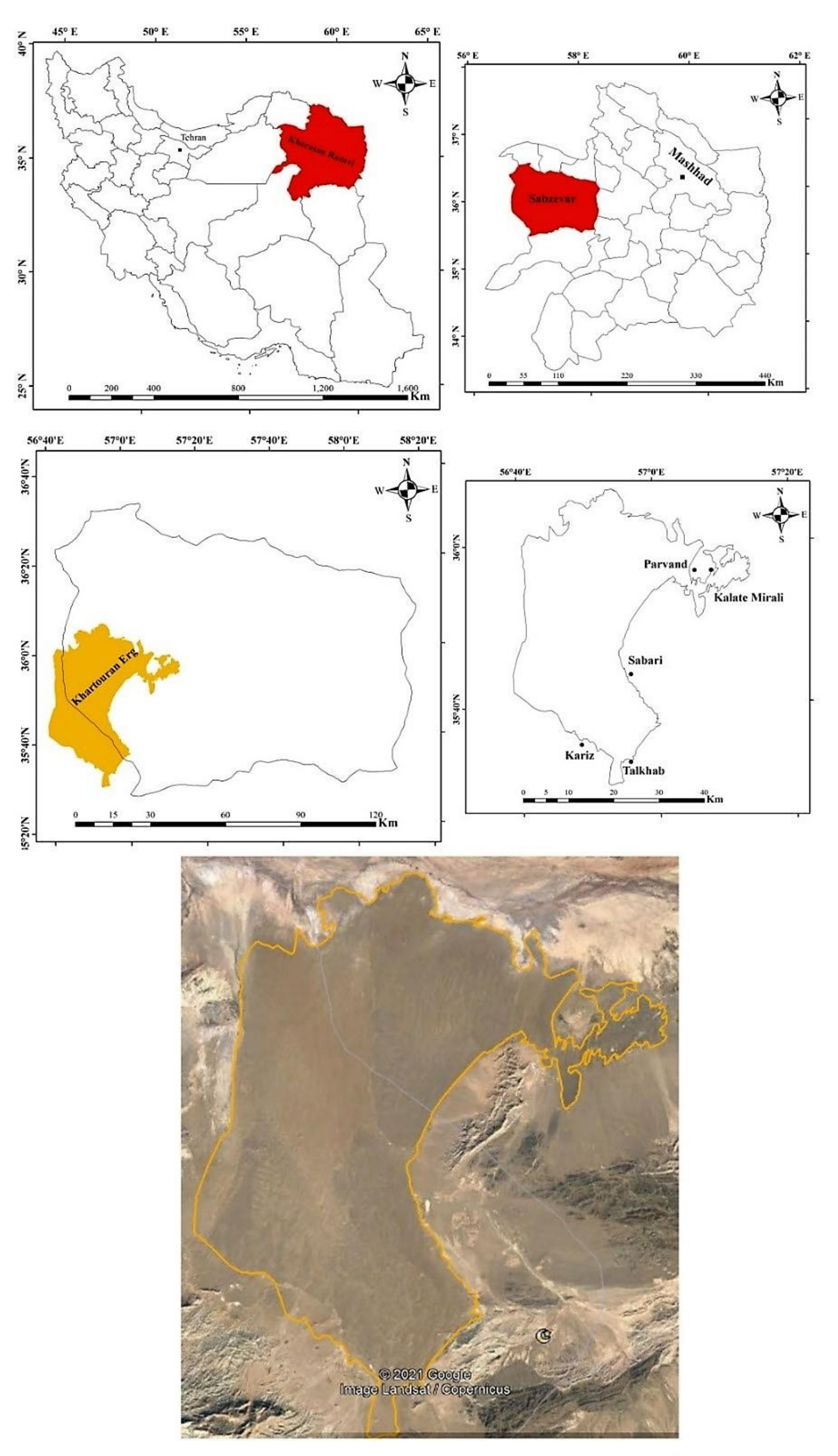
2.1. Study Area
2.2. Methodology
2.2.1. Data Sources
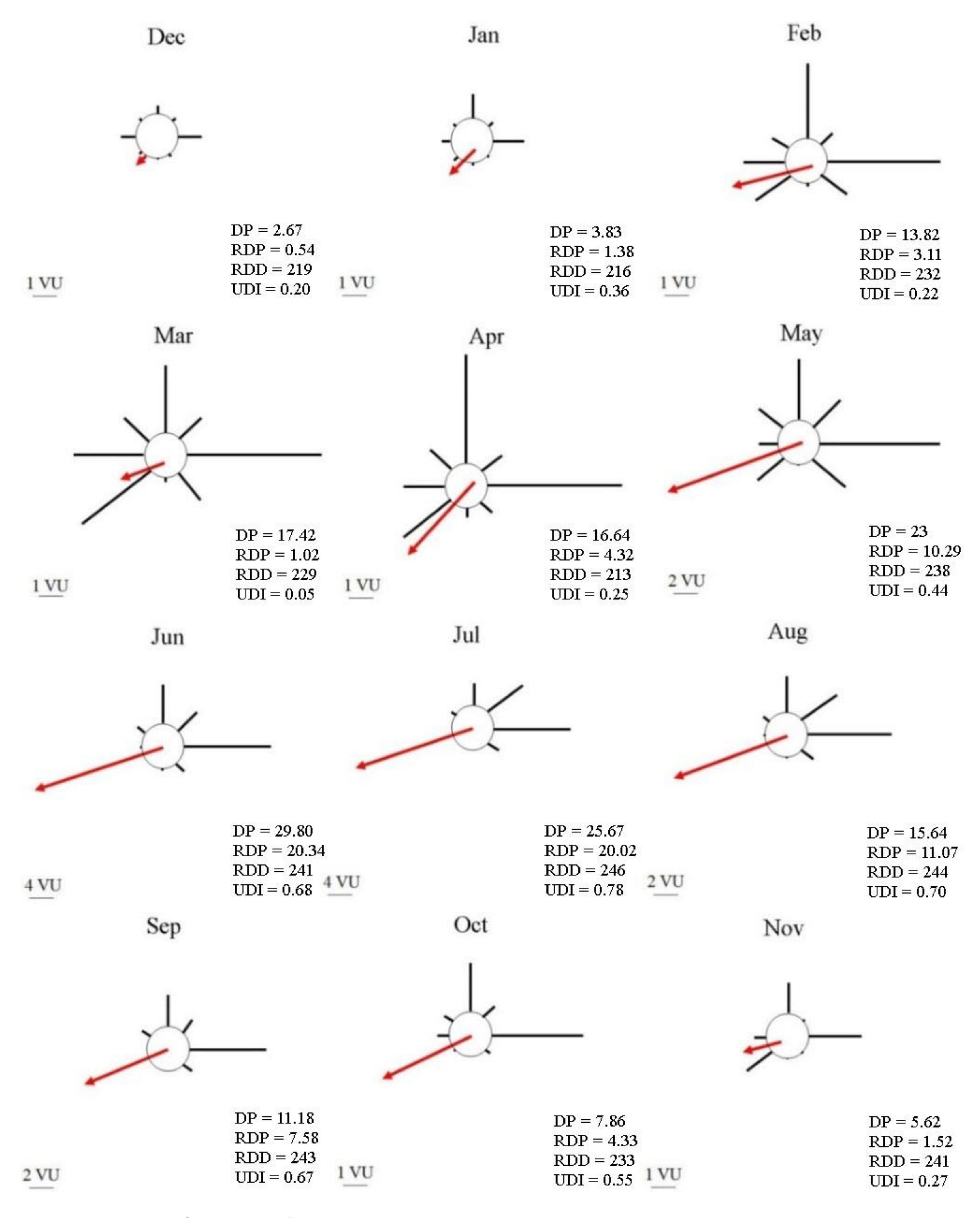
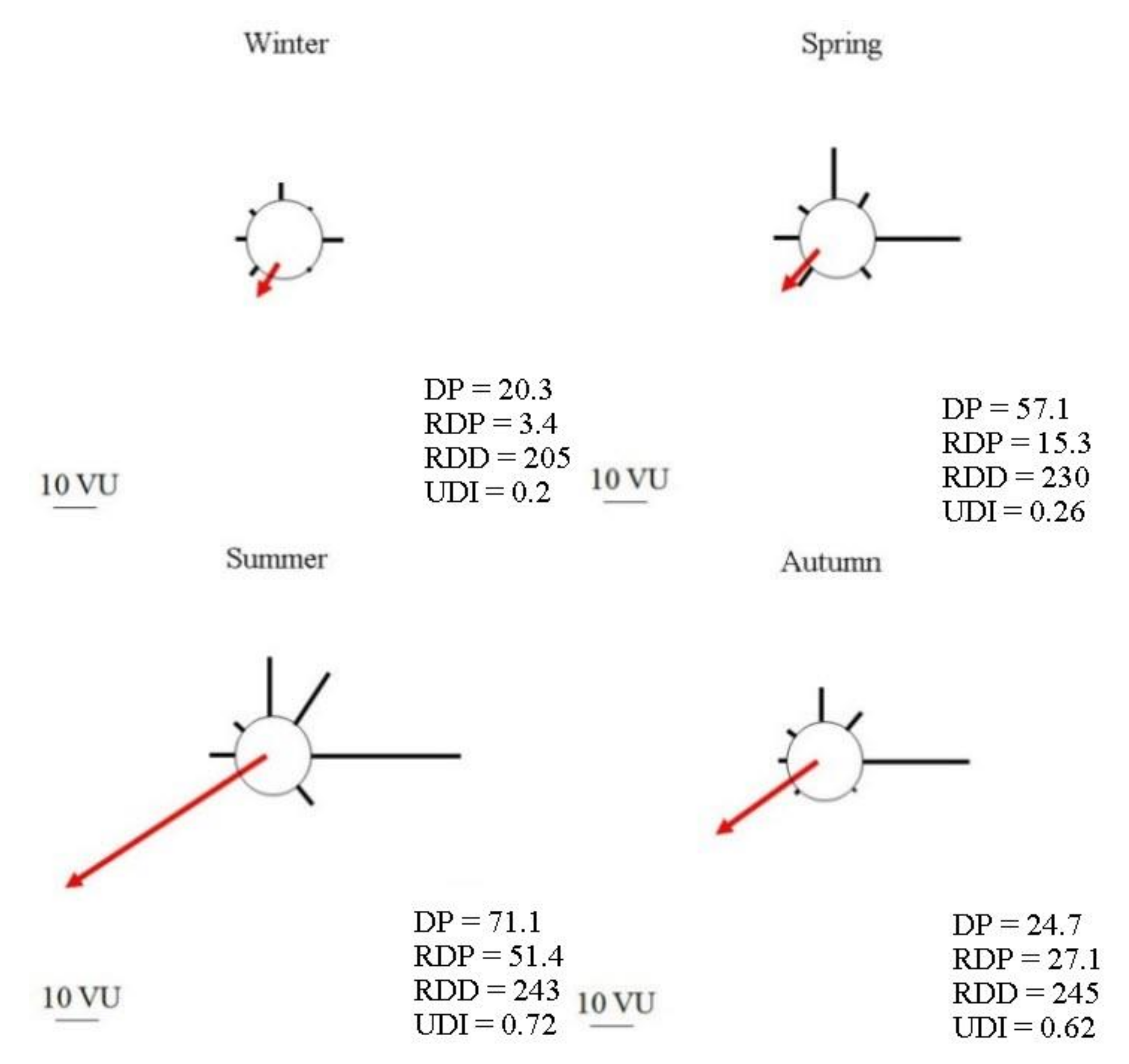
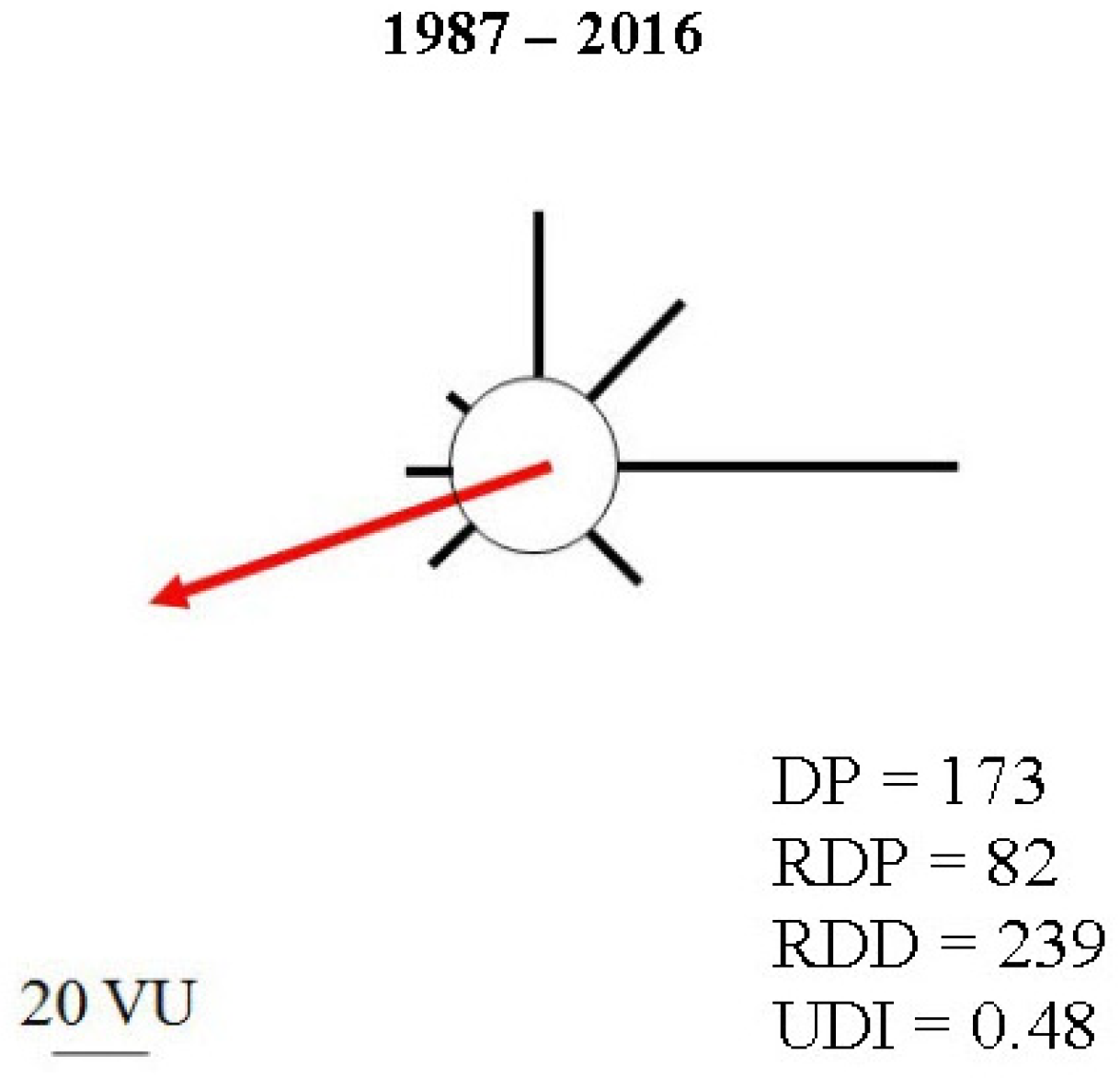
2.2.2. Wind Analysis, Sand Drift Potential, and Sand Mobility
3. Results
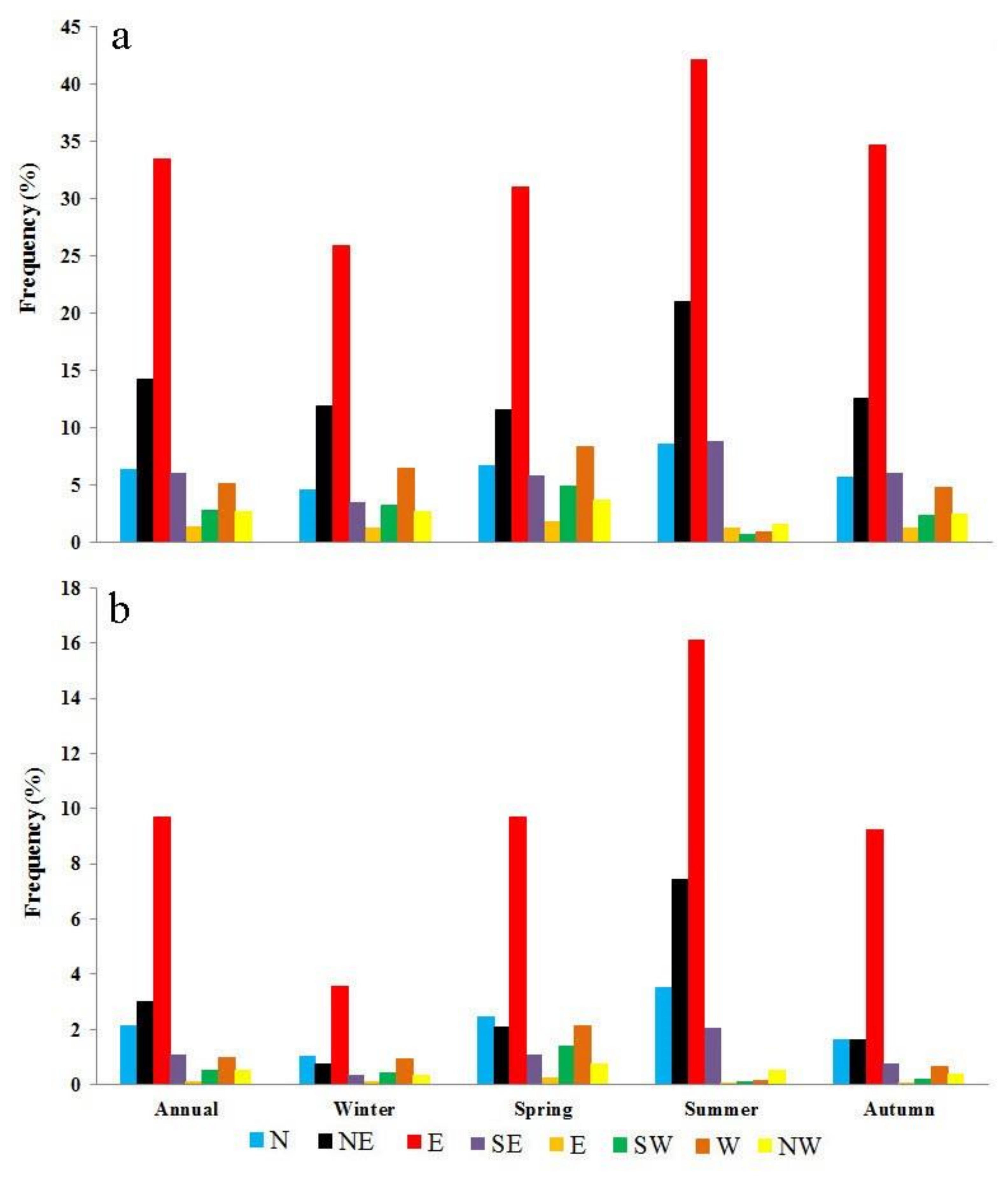
3.1. Wind Analysis
3.2. Sand Drift Potential and Mobility
4. Discussion
4.1. Wind Analysis
4.2. Sand Drift Potential and Mobility
4.3. Evolution of Sand Dunes in Khartouran Erg
5. Conclusions
Author Contributions
Funding
Institutional Review Board Statement
Informed Consent Statement
Data Availability Statement
Acknowledgments
Conflicts of Interest
References
- Rundel, P.; Villagra, P.E.; Dillon, M.O.; Roig-Juñent, S.; Debandi, G. Arid and semi-arid ecosystems. In The Physical Geography of South America; Veblin, T., Young, K., Orme, A., Eds.; Oxford University Press: Oxford, UK, 2007; pp. 158–183. [Google Scholar] [CrossRef]
- Yu, L.; Wu, Z.; Du, Z.; Zhang, H.; Liu, Y. Insights on the roles of climate and human activities to vegetation degradation and restoration in Beijing-Tianjin sandstorm source region. Ecol. Eng. 2021, 159, 106105. [Google Scholar] [CrossRef]
- Su, Y.Z.; Zhao, W.Z.; Su, P.X.; Zhang, Z.H.; Wang, T.; Ram, R. Ecological effects of desertification control and desertified land reclamation in an oasisdesert ecotone in an arid region: A case study in Hexi Corridor, northwest China. Ecol. Eng. 2007, 29, 117–124. [Google Scholar] [CrossRef]
- Yao, Z.; Xiao, J.; Ma, X. The impact of large-scale afforestation on ecological environment in the Gobi region. Sci. Rep. 2021, 11, 14383. [Google Scholar] [CrossRef]
- Heymans, A.; Breadsell, J.; Morrison, G.M.; Byrne, J.J.; Eon, C. Ecological urban planning and design: A systematic literature review. Sustainability 2019, 11, 3723. [Google Scholar] [CrossRef] [Green Version]
- Glavič, P.; Lukman, R. Review of sustainability terms and their definitions. J. Clean. Prod. 2007, 15, 1875–1885. [Google Scholar] [CrossRef]
- Keesstra, S.; Mol, G.; De Leeuw, J.; Okx, J.; De Cleen, M.; Visser, S. Soil-related sustainable development goals: Four concepts to make land degradation neutrality and restoration work. Land 2018, 7, 133. [Google Scholar] [CrossRef] [Green Version]
- Cowling, R.M.; Pressey, R.L.; Lombard, A.T.; Desmet, P.G.; Ellis, A.G. From representation to persistence: Requirements for a sustainable system of conservation areas in the species-rich Mediterranean climate desert of southern Africa. Divers. Distrib. 1999, 5, 51–71. [Google Scholar] [CrossRef]
- Nazari Samani, A.A.; Rahdari, M.R.; Rahi, G. Assessment of Spatial variabilities of Soil Erodibility by Wind on Margial lands of the Lake Urmia. Desert Manag. 2020, 8, 53–72. (In Persian) [Google Scholar]
- Abassi, H.R.; Kashki, M.T.; Rahdari, M.R.; Gohardoust, A.; Lotfi Nasab Asl, S. The Features of Wind’s Regime and Sand Transport Potential in Sarakhs Erg. Iran. J. Range Desert Res. 2020, 27, 371–384. (In Persian) [Google Scholar] [CrossRef]
- Nordstrom, K.F.; Hotta, S. Wind erosion from cropland in the USA: A review of problems, solutions and prospects. Geoderma 2004, 121, 157–167. [Google Scholar] [CrossRef]
- Chi, W.; Zhao, Y.; Kuang, W.; He, H. Impacts of anthropogenic land use/cover changes on soil wind erosion in China. Sci. Total Environ. 2019, 668, 204–215. [Google Scholar] [CrossRef] [PubMed]
- Liu, B.; Wagner, L.E.; Ning, D.; Qu, J. Estimation of wind erosion from construction of a railway in arid Northwest China. Int. Soil Water Conserv. Res. 2017, 5, 102–108. [Google Scholar] [CrossRef]
- Li, J.; Ma, X.; Zhang, C. Predicting the spatiotemporal variation in soil wind erosion across Central Asia in response to climate change in the 21st century. Sci. Total Environ. 2020, 709, 136060. [Google Scholar] [CrossRef]
- Saadoud, D.; Hassani, M.; Peinado, F.J.M.; Guettouche, M.S. Application of fuzzy logic approach for wind erosion hazard mapping in Laghouat region (Algeria) using remote sensing and GIS. Aeolian Res. 2018, 32, 24–34. [Google Scholar] [CrossRef]
- Teng, Y.; Zhan, J.; Liu, W.; Sun, Y.; Agyemang, F.B.; Liang, L.; Li, Z. Spatiotemporal dynamics and drivers of wind erosion on the Qinghai-Tibet Plateau, China. Ecol. Indic. 2021, 123, 107340. [Google Scholar] [CrossRef]
- Valentin, C.; Rajot, J.L.; Mitja, D. Responses of soil crusting, runoff and erosion to fallowing in the sub-humid and semi-arid regions of West Africa. Agric. Ecosyst. Environ. 2004, 104, 287–302. [Google Scholar] [CrossRef]
- Fattahi, S.M.; Soroush, A.; Huang, N.; Zhang, J.; Abbasi, S.J.; Yu, Y. Laboratory study on biophysicochemical improvement of desert sand. Catena 2020, 190, 104531. [Google Scholar] [CrossRef]
- Katra, I. Soil erosion by wind and dust emission in semi-arid soils due to agricultural activities. Agronomy 2020, 10, 89. [Google Scholar] [CrossRef] [Green Version]
- Lyu, X.; Li, X.; Wang, H.; Gong, J.; Li, S.; Dou, H.; Dang, D. Soil wind erosion evaluation and sustainable management of typical steppe in Inner Mongolia, China. J. Environ. Manag. 2021, 277, 111488. [Google Scholar] [CrossRef]
- Solazzo, D.; Sankey, J.B.; Sankey, T.T.; Munson, S.M. Mapping and measuring aeolian sand dunes with photogrammetry and LiDAR from unmanned aerial vehicles (UAV) and multispectral satellite imagery on the Paria Plateau, AZ, USA. Geomorphology 2018, 319, 174–185. [Google Scholar] [CrossRef]
- Mohammadpoor, M.; Eshghizadeh, M. Introducing an intelligent algorithm for extraction of sand dunes from Landsat satellite imagery in terrestrial and coastal environments. J. Coast. Conserv. 2021, 25, 3. [Google Scholar] [CrossRef]
- El-Hadidy, S.M. Monitoring shoreline changes and aeolian sand encroachment, Nasser Lake, Egypt, using remote sensing and GIS techniques. Arab. J. Geosci. 2020, 13, 1285. [Google Scholar] [CrossRef]
- Shao, Y. Physics and Modelling of Wind Erosion; Springer Science & Business Media: Dordrecht, The Netherlands, 2008. [Google Scholar] [CrossRef]
- Webb, N.P.; McCord, S.E.; Edwards, B.L.; Herrick, J.E.; Kachergis, E.; Okin, G.S.; Van Zee, J.W. Vegetation Canopy Gap Size and Height: Critical Indicators for Wind Erosion Monitoring and Management. Rangel. Ecol. Manag. 2021, 76, 78–83. [Google Scholar] [CrossRef]
- Goudie, A.S. Arid and Semi-Arid Geomorphology; Cambridge University Press: Cambridge, UK, 2013. [Google Scholar] [CrossRef]
- Fryberger, S.G. Dune forms and wind regime. In A Study of Global Sand Seas; McKee, E.D., Ed.; US Government Printing Office: Washington, DC, USA, 1979; Volume 1052, pp. 137–169. [Google Scholar] [CrossRef]
- Pye, K.; Tsoar, H. Aeolian Sand and Sand Dunes; Springer Science & Business Media: Berlin/Heidelberg, Germany, 2008. [Google Scholar] [CrossRef]
- Ahmadi, H. Applied Geomorphology (Desert-Wind Erosion); University Of Tehran Press: Tehran, Iran, 2008. (In Persian) [Google Scholar]
- Ahmadi, H. Report of Sand Seas National Project in Iran; University of Tehran: Tehran, Iran, 2004. (In Persian) [Google Scholar]
- Jewell, P.W.; Nicoll, K. Wind regimes and aeolian transport in the Great Basin, USA. Geomorphology 2011, 129, 1–13. [Google Scholar] [CrossRef]
- Tsoar, H.; Blumberg, D.G.; Stoler, Y. Elongation and migration of sand dunes. Geomorphology 2004, 57, 293–302. [Google Scholar] [CrossRef]
- Zhang, Z.; Dong, Z.; Li, C. Wind regime and sand transport in China’s Badain Jaran Desert. Aeolian Res. 2015, 17, 1–13. [Google Scholar] [CrossRef]
- Skidmore, E.L. Wind erosion climatic erosivity. Clim. Chang. 1986, 9, 195–208. [Google Scholar] [CrossRef]
- Shen, Y.; Zhang, C.; Wang, X.; Zou, X.; Kang, L. Statistical characteristics of wind erosion events in the erosion area of Northern China. Catena 2018, 167, 399–410. [Google Scholar] [CrossRef]
- Chang, X.; Sun, L.; Yu, X.; Liu, Z.; Jia, G.; Wang, Y.; Zhu, X. Windbreak efficiency in controlling wind erosion and particulate matter concentrations from farmlands. Agric. Ecosyst. Environ. 2021, 308, 107269. [Google Scholar] [CrossRef]
- Pearce, K.I.; Walker, I.J. Frequency and magnitude biases in the ‘Fryberger’model, with implications for characterizing geomorphically effective winds. Geomorphology 2005, 68, 39–55. [Google Scholar] [CrossRef]
- Lee, J.A.; Gill, T.E. Multiple causes of wind erosion in the Dust Bowl. Aeolian Res. 2015, 19, 15–36. [Google Scholar] [CrossRef]
- Ebrahimi Khusfi, Z.; Khosroshahi, M.; Roustaei, F.; Mirakbari, M. Spatial and seasonal variations of sand-dust events and their relation to atmospheric conditions and vegetation cover in semi-arid regions of central Iran. Geoderma 2020, 365, 114225. [Google Scholar] [CrossRef]
- Nazari Samani, A.A.; Khosravi, H.; Mesbahzadeh, T.; Azarakhshi, M.; Rahdari, M.R. Determination of sand dune characteristics through geomorphometry and wind data analysis in central Iran (Kashan Erg). Arab. J. Geosci. 2016, 9, 716. [Google Scholar] [CrossRef]
- Hereher, M.; Al-Buloshi, A.; Sherief, Y.; Al-Awadhi, T.; Al-Hatrushi, S.; Charabi, Y.; Assal, E. Formation of the Wahiba Sand Sea in the Sultanate of Oman: Implications of change in wind energy. Arab. J. Geosci. 2020, 13, 1183. [Google Scholar] [CrossRef]
- Rahdari, M.R.; Gyasi-Agyei, Y.; Rodrigo-Comino, J. Sand drift potential impacts within desert railway corridors: A case study of the Sarakhs-Mashhad railway line. Arab. J. Geosci. 2021, 14, 810. [Google Scholar] [CrossRef]
- Cheng, J.J.; Jiang, F.Q.; Xue, C.X.; Xin, G.W.; Li, K.C.; Yang, Y.H. Characteristics of the disastrous wind-sand environment along railways in the Gobi area of Xinjiang, China. Atmos. Environ. 2015, 102, 344–354. [Google Scholar] [CrossRef]
- Xie, S.; Qu, J.; Pang, Y. Dynamic wind differences in the formation of sand hazards at high-and low-altitude railway sections. J. Wind. Eng. Ind. Aerodyn. 2017, 169, 39–46. [Google Scholar] [CrossRef]
- Abbasi, H.R.; Opp, C.; Groll, M.; Gohardoust, A. Wind regime and sand transport in the Sistan and Registan regions (Iran/Afghanistan). Z. Geomorphol. 2019, 62, 41–57. [Google Scholar] [CrossRef]
- Xie, S.; Qu, J.; Han, Q.; Pang, Y. Wind dynamic environment and wind tunnel simulation experiment of bridge sand damage in Xierong section of Lhasa–Linzhi Railway. Sustainability 2020, 12, 5689. [Google Scholar] [CrossRef]
- Xie, S.; Qu, J.; Zhang, K.; Han, Q.; Pang, Y. The mechanism of sand damage at the Fushaliang section of the Liuyuan–Golmud expressway. Aeolian Res. 2021, 48, 100648. [Google Scholar] [CrossRef]
- Chepil, W.S.; Siddoway, F.H.; Armbrust, D.V. Climatic factor for estimating wind erodibility of farm fields. J. Soil Water Conserv. 1962, 17, 162. [Google Scholar]
- Wasson, R.J.; Smith, G.I.; Agrawal, D.P. Late Quaternary sediments, minerals, and inferred geochemical history of Didwana Lake, Thar desert, India. Palaeogeogr. Palaeoclimatol. Palaeoecol. 1984, 46, 345–372. [Google Scholar] [CrossRef]
- Lancaster, N. Development of linear dunes in the southwestern Kalahari, southern Africa. J. Arid Environ. 1988, 14, 233–244. [Google Scholar]
- Tsoar, H. Sand dunes mobility and stability in relation to climate. Physica A 2005, 357, 50–56. [Google Scholar] [CrossRef]
- Sterk, G. Causes, consequences and control of wind erosion in Sahelian Africa: A review. Land Degrad Dev. 2003, 14, 95–108. [Google Scholar] [CrossRef]
- Uzun, O.; Kaplan, S.; Ince, K.; Basaran, M.; Erpul, G. Spatially and temporally assessing event-based wind erosion in adjacent plots of fallow and wheat cultivation in the Central Anatolia, Turkey. Arch. Agron. Soil Sci. 2020, in press. [Google Scholar] [CrossRef]
- Wu, Y.K.; Hong, J.S. A literature review of wind forecasting technology in the world. IEEE Lausanne Power Tech. 2007, 246, 504–509. [Google Scholar] [CrossRef]
- Soman, S.S.; Zareipour, H.; Malik, O.; Mandal, P. A review of wind power and wind speed forecasting methods with different time horizons. In Proceedings of the IEEE North American Power Symposium 2010, Arlington, TX, USA, 26–28 September 2010; pp. 1–8. [Google Scholar] [CrossRef]
- Chen, N.; Qian, Z.; Nabney, I.T.; Meng, X. Wind power forecasts using Gaussian processes and numerical weather prediction. IEEE Trans. Power Syst. 2014, 29, 656–665. [Google Scholar] [CrossRef] [Green Version]
- Yizhaq, H.; Ashkenazy, Y.; Tsoar, H. Sand dune dynamics and climate change: A modeling approach. J. Geophys. Res. Earth Surf. 2009, 114, F01023. [Google Scholar] [CrossRef] [Green Version]
- Wu, L.; Cheng, W.; Zhu, Z. Fractional-Order Elastoplastic Modeling of Sands Considering Cyclic Mobility. J. Mar. Sci. Eng. 2021, 9, 354. [Google Scholar] [CrossRef]
- Rahdari, M.R. Potential Modeling of Sand Deposition on Railways. Ph.D. Thesis, Faculty of Natural Resources, University of Tehran, Tehran, Iran, 2018. (In Persian). [Google Scholar]
- Mesbah Zadeh, T.; Ahmadi, H. The role of wind regime in discharge rate and the transfer of sediments in sand dunes (Case study: Sabzevar). Geogr. Res. 2011, 99, 101–114. (In Persian) [Google Scholar]
- Jahanbakhsh Asl, S.; Asadi, M.; Akbari, E. The potential of the power in Sabzevar. Geogr. Plan. 2016, 20, 55–72. (In Persian) [Google Scholar]
- Mehrshahi, D.; Nekounam, Z. Statistical analysis of dust and dust wind patterns in Sabzevar city. J. Geogr. 2009, 7, 83–104. (In Persian) [Google Scholar]
- Omidvar, K.; Nekounam, Z. Application of wind rose and dust rose in the analysis of dust phenomenon. Phys. Geogr. Res. 2011, 76, 85–104. Available online: https://jphgr.ut.ac.ir/article_23072_0.html?lang=en (accessed on 30 April 2011).
- Mashhadi, N.; Feiznia, S. The study of removal (detachment) and transitional regions of wind erosion upon ground indicator (Case study: Khartouran Erg). Desert 2008, 13, 75–87. [Google Scholar] [CrossRef]
- Khodajou, M.A.; Ahmadi, H. Identification of detachment facies in Khartouran ERG. For. Rangel. 2011, 89, 74–78. (In Persian) [Google Scholar]
- Mahmoodi, F.A. Report of Sand Seas Research Project in Iran; University of Tehran: Tehran, Iran, 1991. (In Persian) [Google Scholar]
- Abbasi, H.R. Classification of Iran’s Sand Dune Systems: Morphology and Physiochemical Properties; Technical Final Report; Research Institute of Forests and Ranglands Iran: Tehran, Iran, 2012. (In Persian) [Google Scholar]
- IRIMO. Islamic Republic of Iran Meteorological Organization. 2017. Available online: http://www.irimo.ir (accessed on 30 April 2017).
- Delbari, M.; Delbari, Z.; Sheikh, V.; Biroodian, N.; Filecesh, I. Floristic study And Ecological characteristics of rangelands in the Sandy land of Sabzevar of Sabzevar plain. PEC 2017, 5, 75–86. Available online: http://pec.gonbad.ac.ir/article-1-180-en.html (accessed on 30 April 2017). (In Persian).
- Hereher, M.E. Geomorphology and drift potential of major aeolian sand deposits in Egypt. Geomorphology 2018, 304, 113–120. [Google Scholar] [CrossRef]
- Louassa, S.; Merzouk, M.; Merzouk, N.K. Sand drift potential in western Algerian Hautes Plaines. Aeolian Res. 2018, 34, 27–34. [Google Scholar] [CrossRef]
- Thomas, D.S.; Knight, M.; Wiggs, G.F. Remobilization of southern African desert dune systems by twenty-first century global warming. Nature 2005, 435, 1218–1221. [Google Scholar] [CrossRef]
- Tsoar, H. The ecological background, deterioration and reclamation of desert dune sand. Agric. Ecosyst. Environ. 1990, 33, 147–170. [Google Scholar] [CrossRef]
- Sirjani, E.; Sameni, A.; Moosavi, A.A.; Mahmoodabadi, M.; Laurent, B. Portable wind tunnel experiments to study soil erosion by wind and its link to soil properties in the Fars province, Iran. Geoderma 2019, 333, 69–80. [Google Scholar] [CrossRef]
- Gautam, D.; Adhikari, R.; Jha, P.; Rupakhety, R.; Yadav, M. Windstorm vulnerability of residential buildings and infrastructures in south-central Nepal. J. Wind. Eng. Ind. Aerodyn. 2020, 198, 104113. [Google Scholar] [CrossRef]
- Changnon, S.A. Temporal and spatial distributions of wind storm damages in the United States. Clim. Chang. 2009, 94, 473–482. [Google Scholar] [CrossRef]
- Katra, I.; Gross, A.; Swet, N.; Tanner, S.; Krasnov, H.; Angert, A. Substantial dust loss of bioavailable phosphorus from agricultural soils. Sci. Rep. 2016, 6, 24736. [Google Scholar] [CrossRef] [Green Version]
- Yizhaq, H.; Xu, Z.; Ashkenazy, Y. The effect of wind speed averaging time on the calculation of sand drift potential: New scaling laws. Earth Planet. Sci. Lett. 2020, 544, 116373. [Google Scholar] [CrossRef]
- Ziyaee, A.; Karimi, A.; Hirmas, D.R.; Kehl, M.; Lakzian, A.; Khademi, H.; Mechem, D.B. Spatial and temporal variations of airborne dust fallout in Khorasan Razavi Province, Northeastern Iran. Geoderma 2018, 326, 42–55. [Google Scholar] [CrossRef]
- Ziyaee, A.; Hirmas, D.R.; Karimi, A.; Kehl, M.; Macpherson, G.L.; Lakzian, A.; Roshanizarmehri, M. Geogenic and anthropogenic sources of potentially toxic elements in airborne dust in northeastern Iran. Aeolian Res. 2019, 41, 100540. [Google Scholar] [CrossRef]
- Cao, H.; Liu, J.; Wang, G.; Yang, G.; Luo, L. Identification of sand and dust storm source areas in Iran. J. Arid Land 2015, 7, 567–578. [Google Scholar] [CrossRef]
- Yarmoradi, Z.; Nasiri, B.; Mohammadi, G.H.; Karampour, M. Long-term characteristics of the observed dusty days and its relationship with climatic parameters in East Iran. Arab. J. Geosci. 2020, 13, 242. [Google Scholar] [CrossRef]
- Mostafaeipour, A.; Sedaghat, A.; Ghalishooyan, M.; Dinpashoh, Y.; Mirhosseini, M.; Sefid, M.; Pour-Rezaei, M. Evaluation of wind energy potential as a power generation source for electricity production in Binalood, Iran. Renew. Energy 2013, 52, 222–229. [Google Scholar] [CrossRef]
- Alamdari, P.; Nematollahi, O.; Mirhosseini, M. Assessment of wind energy in Iran: A review. Renew. Sustain. Energy Rev. 2012, 16, 836–860. [Google Scholar] [CrossRef]
- Kharazmi, R.; Tavili, A.; Rahdari, M.R.; Chaban, L.; Panidi, E.; Rodrigo-Comino, J. Monitoring and assessment of seasonal land cover changes using remote sensing: A 30-year (1987–2016) case study of Hamoun Wetland, Iran. Environ. Monit. Assess. 2018, 190, 356. [Google Scholar] [CrossRef] [PubMed]
- Modarres, R.; da Silva, V.D.P.R. Rainfall trends in arid and semi-arid regions of Iran. J. Arid Environ. 2007, 70, 344–355. [Google Scholar] [CrossRef]
- Abbasi, H.R.; Opp, C.; Groll, M.; Rohipour, H.; Gohardoust, A. Assessment of the distribution and activity of dunes in Iran based on mobility indices and ground data. Aeolian Res. 2019, 41, 100539. [Google Scholar] [CrossRef]
- Mashhadi, N.; Feiznia, S.; Abdi, S. Dynamic and genetic analysis of wind sediments to determine the origin and source of sand. Phys. Geogr. Res. 2019, 51, 389–402. (In Persian) [Google Scholar] [CrossRef]
- Malamiri, N.; Hossenzadeh, S.R.; Khosroshahabadi, R. Assessing the theory of spatial stability of Ergs in Iran, using remote sensing data. J. Arid. Geo. Std. 2017, 7, 23–35. Available online: http://journals.hsu.ac.ir/jarhs/article-1-1198-en.html (accessed on 30 April 2017). (In Persian).
- Silakhoori, E.; Vahab zadeh, D.; Parisay, Z. Assessment of the Risk for Water and Wind Erosion and Comparison of Their Sedimentation Potential in Hares-Abad Region in Sabzevar. Geogr. Terr. Spat. Arrang. 2017, 7, 85–98. (In Persian) [Google Scholar] [CrossRef]
- Poorjavad, H.; Rashki, A.R.; Hoseinalizadeh, M. Assessing the influence of plant species on wind erosion in arid regions: A case study of the Sebri region of Sabzevar, Iran. Desert Ecosyst. Eng. J. 2017, 6, 21–32. (In Persian) [Google Scholar]
- Entezari, A.R.; Amir Ahmadi, A.; Erfani, A.; Bourzouei, A. Evaluation of wind energy potential and feasibility of construction of wind power plant in Sabzevar. J. Arid. Geo. Std. 2013, 3, 33–46. (In Persian) [Google Scholar]
- Games, K.P.; Gordon, D.I. Study of sand wave migration over five years as observed in two windfarm development areas, and the implications for building on moving substrates in the North Sea. Earth Environ. Sci. Trans. R. Soc. Edinb. 2014, 105, 241–249. [Google Scholar] [CrossRef]
- Maldonado, S. The Importance of New “Sand-to-Silicon” Processes for the Rapid Future Increase of Photovoltaics. ACS Energy Lett. 2020, 5, 3628–3632. [Google Scholar] [CrossRef]
- Hancock, M.H.; Klein, D.; Andersen, R.; Cowie, N.R. Vegetation response to restoration management of a blanket bog damaged by drainage and afforestation. Appl. Veg. Sci. 2018, 21, 167–178. [Google Scholar] [CrossRef]
- Khorchani, M.; Nadal-Romero, E.; Tague, C.; Lasanta, T.; Zabalza, J.; Lana-Renault, N.; Dominguez-Castro, F.; Choate, J. Effects of active and passive land use management after cropland abandonment on water and vegetation dynamics in the Central Spanish Pyrenees. Sci. Total Environ. 2020, 717, 137160. [Google Scholar] [CrossRef]
- Al-Dousari, A.; Ramadan, A.; Al-Qattan, A.; Al-Ateeqi, S.; Dashti, H.; Ahmed, M.; Al-Dousari, N.; Al-Hashash, N.; Othman, A. Cost and effect of native vegetation change on aeolian sand, dust, microclimate and sustainable energy in Kuwait. J. Taibah Univ. 2020, 14, 628–639. [Google Scholar] [CrossRef]


| Month | N | NE | E | SE | S | SW | W | NW | Calm Winds |
|---|---|---|---|---|---|---|---|---|---|
| January | 3.56 | 12.54 | 26.22 | 3.33 | 1.35 | 2.9 | 5.90 | 2.59 | 41.61 |
| February | 6.14 | 11.92 | 26.54 | 4.05 | 1.59 | 3.9 | 7.84 | 3.36 | 34.66 |
| March | 5.96 | 12.02 | 27.50 | 4.66 | 1.65 | 5.32 | 9.47 | 3.8 | 29.62 |
| April | 5.76 | 10.77 | 30.48 | 5.13 | 2.12 | 5.75 | 9.25 | 3.91 | 26.83 |
| May | 8.17 | 11.89 | 35.16 | 7.71 | 1.77 | 3.61 | 6.29 | 3.38 | 22.02 |
| June | 9.15 | 18.63 | 42.36 | 7.73 | 1.50 | 1.36 | 1.95 | 2.30 | 15.02 |
| July | 7.88 | 24.26 | 42.59 | 8.83 | 1.15 | 0.44 | 0.28 | 1.29 | 13.28 |
| August | 8.57 | 19.93 | 41.55 | 9.87 | 1.23 | 0.37 | 0.37 | 1.23 | 16.88 |
| September | 6.01 | 12.93 | 43.20 | 9.08 | 1.25 | 1.59 | 2.62 | 2.01 | 21.31 |
| October | 6.07 | 12.43 | 33.50 | 5.60 | 1.26 | 2.21 | 5.87 | 2.86 | 30.20 |
| November | 5.06 | 12.48 | 27.37 | 3.45 | 1.29 | 3.36 | 5.91 | 2.66 | 38.42 |
| December | 4.08 | 11.29 | 24.89 | 3.19 | 1.06 | 2.95 | 5.68 | 2.31 | 44.55 |
| Min | 3.56 | 10.77 | 24.89 | 3.19 | 1.06 | 0.37 | 0.28 | 1.23 | 13.28 |
| Max | 9.15 | 24.26 | 43.20 | 9.87 | 2.12 | 5.75 | 9.47 | 3.91 | 44.55 |
| Average | 6.37 | 14.26 | 33.45 | 6.05 | 1.44 | 2.81 | 5.12 | 2.64 | 26.74 |
| Standard deviation | 1.68 | 4.08 | 6.96 | 2.35 | 0.29 | 1.65 | 3.02 | 0.84 | 10.04 |
| Month | N | NE | E | SE | S | SW | W | NW |
|---|---|---|---|---|---|---|---|---|
| January | 27.63 | 9.51 | 33.92 | 1.37 | 3.23 | 8.34 | 9.27 | 6.94 |
| February | 22.70 | 4.24 | 34.11 | 7.71 | 1.09 | 13.00 | 11.70 | 5.49 |
| March | 16.13 | 4.11 | 32.47 | 4.68 | 1.11 | 20.07 | 16.60 | 4.84 |
| April | 26.93 | 3.56 | 33.96 | 2.83 | 2.08 | 13.19 | 10.02 | 7.49 |
| May | 22.12 | 9.44 | 41.63 | 7.44 | 0.44 | 5.31 | 7.67 | 5.97 |
| June | 22.57 | 16.65 | 49.34 | 5.08 | 0.14 | 0.88 | 1.38 | 3.97 |
| July | 14.18 | 28.24 | 49.07 | 5.81 | 0.08 | 0.04 | 0.04 | 2.56 |
| August | 19.48 | 21.35 | 45.59 | 8.76 | 0.79 | 0.02 | 0.06 | 4.00 |
| September | 23.31 | 10.60 | 55.20 | 4.10 | 0.06 | 0.96 | 0.84 | 5.02 |
| October | 26.63 | 7.46 | 48.60 | 3.29 | 0.08 | 1.52 | 6.48 | 6.00 |
| November | 22.33 | 7.71 | 39.58 | 1.55 | 0.73 | 19.05 | 8.19 | 0.93 |
| December | 13.26 | 5.97 | 37.21 | 5.94 | 0.23 | 6.02 | 21.56 | 9.82 |
| Min | 13.26 | 3.56 | 32.47 | 1.37 | 0.06 | 0.02 | 0.04 | 0.93 |
| Max | 27.63 | 28.24 | 55.20 | 8.76 | 3.23 | 20.07 | 21.56 | 9.82 |
| Average | 21.44 | 10.74 | 41.72 | 4.88 | 0.84 | 7.37 | 7.82 | 5.25 |
| Standard deviation | 4.61 | 7.29 | 7.33 | 2.28 | 0.92 | 7.04 | 6.46 | 2.22 |
| Year | DP (VU) | RDP (VU) | UDI | Mobility |
|---|---|---|---|---|
| 1987 | 61 | 18 | 0.29 | 0.08 |
| 1988 | 135 | 63 | 0.46 | 0.21 |
| 1989 | 114 | 59 | 0.51 | 0.19 |
| 1990 | 145 | 85 | 0.59 | 0.26 |
| 1991 | 95 | 51 | 0.54 | 0.16 |
| 1992 | 97 | 34 | 0.34 | 0.13 |
| 1993 | 102 | 41 | 0.4 | 0.15 |
| 1994 | 192 | 108 | 0.55 | 0.33 |
| 1995 | 134 | 55 | 0.41 | 0.19 |
| 1996 | 93 | 59 | 0.63 | 0.18 |
| 1997 | 103 | 29 | 0.28 | 0.13 |
| 1998 | 139 | 57 | 0.41 | 0.20 |
| 1999 | 101 | 44 | 0.44 | 0.15 |
| 2000 | 89 | 39 | 0.49 | 0.13 |
| 2001 | 64 | 29 | 0.45 | 0.10 |
| 2002 | 134 | 50 | 0.37 | 0.19 |
| 2003 | 65 | 26 | 0.39 | 0.09 |
| 2004 | 125 | 48 | 0.38 | 0.18 |
| 2005 | 176 | 94 | 0.53 | 0.29 |
| 2006 | 400 | 209 | 0.52 | 0.66 |
| 2007 | 362 | 173 | 0.47 | 0.56 |
| 2008 | 539 | 289 | 0.53 | 0.90 |
| 2009 | 300 | 176 | 0.58 | 0.54 |
| 2010 | 225 | 133 | 0.59 | 0.40 |
| 2011 | 199 | 125 | 0.62 | 0.38 |
| 2012 | 220 | 113 | 0.51 | 0.36 |
| 2013 | 151 | 85 | 0.56 | 0.26 |
| 2014 | 147 | 67 | 0.47 | 0.22 |
| 2015 | 165 | 103 | 0.62 | 0.31 |
| 2016 | 132 | 68 | 0.51 | 0.22 |
| Min | 61 | 18 | 0.28 | 0.08 |
| Max | 539 | 289 | 0.63 | 0.90 |
| Average | 166.8 | 84.33 | 0.48 | 0.27 |
| Standard deviation | 105.48 | 60.3 | 0.09 | 0.18 |
Publisher’s Note: MDPI stays neutral with regard to jurisdictional claims in published maps and institutional affiliations. |
© 2021 by the authors. Licensee MDPI, Basel, Switzerland. This article is an open access article distributed under the terms and conditions of the Creative Commons Attribution (CC BY) license (https://creativecommons.org/licenses/by/4.0/).
Share and Cite
Rahdari, M.R.; Rodríguez-Seijo, A. Monitoring Sand Drift Potential and Sand Dune Mobility over the Last Three Decades (Khartouran Erg, Sabzevar, NE Iran). Sustainability 2021, 13, 9050. https://doi.org/10.3390/su13169050
Rahdari MR, Rodríguez-Seijo A. Monitoring Sand Drift Potential and Sand Dune Mobility over the Last Three Decades (Khartouran Erg, Sabzevar, NE Iran). Sustainability. 2021; 13(16):9050. https://doi.org/10.3390/su13169050
Chicago/Turabian StyleRahdari, Mohammad Reza, and Andrés Rodríguez-Seijo. 2021. "Monitoring Sand Drift Potential and Sand Dune Mobility over the Last Three Decades (Khartouran Erg, Sabzevar, NE Iran)" Sustainability 13, no. 16: 9050. https://doi.org/10.3390/su13169050