Article

An Integrated Information System of Climate-Water-Migrations-Conflicts Nexus in the Congo Basin

by
Raphael M. Tshimanga
1,*,
Génie-Spirou K. Lutonadio
1,
Nana K. Kabujenda
1,
Christian M. Sondi
1,
Emmanuel-Tsadok N. Mihaha
1,
Jean-Felly K. Ngandu
1,
Landry N. Nkaba
1,
Gerard M. Sankiana
1,
Jules T. Beya
1,
Anaclet M. Kombayi
1,
Lisette M. Bonso
1,
Augustin L. Likenge
1,
Nicole M. Nsambi
1,
Prisca Z. Sumbu
1,
Yuma Bin Yuma
1,
Michel K. Bisa
2 and
Bernard M. Lututala
3
1
Congo Basin Water Resources Research Center-CRREBaC, Department of Natural Resources Management, Faculty of Agricultural Engineering, University of Kinshasa, DRC, Kin XI, Kinshasa P.O. Box 117, Democratic Republic of the Congo
2
Faculty of Social, Administrative and Political Sciences, University of Kinshasa, Kinshasa P.O. Box 117, Democratic Republic of the Congo
3
Department of Population and Development Studies, Faculty of Economics and Management, University of Kinshasa, Kinshasa P.O. Box 117, Democratic Republic of the Congo
*
Author to whom correspondence should be addressed.
Sustainability 2021, 13(16), 9323; https://doi.org/10.3390/su13169323
Submission received: 31 May 2021 / Revised: 13 July 2021 / Accepted: 30 July 2021 / Published: 19 August 2021
(This article belongs to the Special Issue Modelling and Simulation of Human-Environment Interactions)

Abstract

:
We present an integrated information system needed to address the climate-water-migration-conflict nexus in the Congo Basin. It is based on a rigorous and multidisciplinary methodological approach that consists of designing appropriate tools for field surveys and data collection campaigns, data analysis, creating a statistical database and creating a web interface with the aim to make this information system publicly available for users and stakeholders. The information system developed is a structured and organized set of quantitative and qualitative data on the climate-water-migration-conflict nexus and gender, consisting of primary data collected during field surveys. It contains 250 aggregated variables or 575 disaggregated variables, all grouped into 15 thematic areas, including identification; socio-demographic characteristics; access to resources; perception of climate change; perception of migration; financial inclusion (savings, access to credit and circulation of money); domination and control on water resources, land ownership and property rights, conflict resolution and community resilience; water uses; vulnerability to climate change; housing, household assets and household expenditure; food security; health, hygiene and sanitation; environmental risk management; women’s economic autonomy; and water transfer from the Congo Basin to Lake Chad. The information system can be used to model and understand the interface of human-environment interactions, and develop scenarios necessary to address the challenges of climate change and resilient development, while supporting key policy areas and strategies to foster effective stakeholder participation to ensure management and governance of climate and natural resources in the Congo Basin.

1. Introduction

Climate and water are the linchpins of life on the planet Earth, including the distribution of biodiversity, socio-economic development and the maintenance of ecosystems. Ecological and socio-economic productivity are therefore a function of the spatial and temporal distribution of climate and water. Land use and climate change include a complex component of human-environment interactions. Impacts can be environmental, social or economic, thus contributing to the vulnerability of riparian communities. Vulnerability to change varies between social groups, depending on their geographical location, social and economic status, level of exposure to change and ability to cope or adapt to change. Human vulnerability and the ability to cope or adapt depends on access to social and economic goods and services and the degree of exposure to economic and social stress. Modelling the complex interaction of human-environment interface is of paramount importance to effectively address the issues of resilient development. Unfortunately, there is always a lack of appropriate data at the required scales of decision making.
In the region of the Congo Basin, human factors as well as hydro-climatic and environmental dimensions are multifaceted, complex and difficult to integrate, particularly in situations of data scarcity and non-stationary resources availability at different scales. These challenges are accentuated in the context where social, economic and political conditions have not recognized the need for up-to-date hydro-climatic, environmental or their associated socio-economic data, or where the resources to collect and interpret these data are not available.
Trigg and Tshimanga [1] mention that the Congo Basin is an especially important ecosystem not only because it is very large but also because we are only now beginning to understand its uniqueness. It is the second-largest river system in the world and supports millions of livelihoods through agriculture, transport, fishing and timber, and yet we know relatively little about how it functions. Emerging evidence suggests that change in the pattern of land use (human factors) and climate change (environmental factors) pose substantial threats to water resource availability in the Congo Basin [2]. Activities such as deforestation, uncontrolled mining and settlements exert unprecedented pressure on the available natural resources across the basin scales as well as their natural variability and heterogeneity. The direct impacts of climate change, in the basin—such as changes in seasonal rainfall and temperature distribution, land use, hydrological regimes and water-use patterns—are predictable [3]. These effects amplify the vulnerability of about 120 million people across the Congo Basin, who depend on rain-fed agriculture and basin resources for their livelihoods and socio-economic well-being. They all have a negative influence on the subsistence economy for local communities through their impact on agricultural production and food security. Predictably, the groups living in the most vulnerable situations, including women and girls, are the most adversely affected [4,5].
In addition to the above-mentioned drivers of change, there is a new trend of human pressure that results from migration of Mbororo pastoralist communities from Lake Chad region to the Congo Basin, particularly in the north-eastern part of the Democratic Republic of Congo. Kabamba [6], explains that for many African countries, seasonal migration of pastoralist communities is a cultural practice and a traditional approach to adapting to environmental changes. However, the increasing intensification and unpredictability of climate change is hampering the ability of these communities to use migration as an effective response to seasonal variations. The climatic variability observed in the Sahel region surrounding the Lake Chad Basin, combined with the rapid increase in population growth and along with inefficient practices of managing available water, particularly in the Lake Chad Basin [7] is of particular concern while assessing newer patterns of migration and associated conflicts currently observed in the Congo Basin. The mass movements of Mbororo pastoralist communities or herders from the Lake Chad region to the Congo Basin has been recently identified as an important migration route in the region [6,8]. These communities have entered the northern countries of the Congo Basin—the DRC, Central African Republic (CAR), Cameroon and South Sudan—and multiple episodes of land and water conflicts have been recorded [9]. These migratory movements have increased over the past two decades due to several direct and indirect factors, most often related to climate variability, land occupation, natural resources’ degradation and armed conflicts [10]. This has led to the replacement of traditional trends in human mobility with new migration patterns driven by the needs of communities to access natural resources, including water, land and pasture. The result is the emergence of newer types of conflicts. This trend weakens the balance and cultural exchanges between migrants and resident communities. In this north-eastern part of the DRC, local communities have already been paying a heavy price over the past three decades of armed conflicts and civil wars, internal displacement of populations, illegal exploitation and degradation of natural resources, lack of basic socio-economic structures, and acute poverty. Moreover, the issue of inter-basin water transfer from the Congo to maintain and revitalize the water level of Lake Chad is a regional agenda of the major political, socio-economic and scientific concerns, and is at the heart of intense debates that sometimes involve the theory of “water war” or socio-political conflicts triggered by water [11]. The context of the “Water War” as evoked by Mutinga [12], and in some public debates (Economic and Social Council- DRC, 2019; National Assembly-DRC, March 2020 Session), identifies water-related conflicts as the main threat to biological and cultural diversity in the Congo Basin.
In this context, a thorough understanding of the interactions between climate, water, migration and conflict at the regional level is becoming relevant. This has been the focus of a research and capacity building initiative: “Addressing climate- and water-driven migration and conflict interlinkages to build community resilience in the Congo Basin (Available online: https://www.crrebac.org/en_GB/projet-climat-eau-migration-conflit (accessed on 1 April 2021))”, implemented by the Congo Basin Water Resources Research Center -CRREBaC in collaboration with the United Nations University—Institute for Water, Health and Environment, under the financial support of the International Development Research Centre (IDRC). The emerging new migration pathways induced by various direct and indirect factors require a comprehensive understanding of regional and sub-regional dimensions to define a practical approach and appropriate strategies to ensure security, peace and socio-economic well-being. Measures to develop such strategies for adaptation to these changes should be at the center not only of public policies, but also of technical assistance and capacity development agendas toward sustainable solutions for human development, environmental sustainability and community resilience.
All this together means that an adequate integrated information system is required in support of a holistic and multidisciplinary approach to address the complexity of human-environment interaction issues for resilient development in the Congo Basin. The aim of this paper is therefore to present an integrated information system needed to address the climate-water-migration-conflict nexus in the Congo Basin, as well as the methodological approaches used for data production, building the database and setting up an open access infrastructure of this information system.
The information system presented in this paper is intended to address the challenges of climate change and resilient development, while supporting key policy areas and strategies to foster effective stakeholder participation to ensure the management and governance of climate and natural resources, and gender consideration in all aspects, both at national, basin and regional levels. It aligns with the development plans of countries in the Congo Basin region, fits well in support of the implementation of Sustainable Development Goals (SGDs), can help strengthen the capacity of local communities, and empowers women and benefits youth through insights for income and livelihood diversification activities. It also integrates an applied research dimension towards providing practical knowledge for decision makers and other stakeholders, along with enhanced understanding of the vulnerabilities, exposure and risk and to participatory design of long-term investment and development strategies.

2. Study Region

The climate-water-migrations-conflicts nexus investigated in the study is complex and multi-faceted and involves several countries in North Africa, West Africa, Central Africa and East Africa, including Libya, Niger, Sudan, Nigeria, Cameroon, Chad, the Central African Republic (CAR), the Republic of Congo, the DRC, South Sudan and Uganda. Climate variability and change is of particular concern in this region, with implications for the availability of water and natural resources for communities, especially nomadic pastoralists. The resulting effects of these implications relate to the current migration trends, which trigger communities’ conflicts in the northern part of the DRC, and also influence transboundary water governance across the Congo Basin. Therefore, this study considers these countries as a region of interaction or influence of the climate-water-migration-conflicts nexus in order to establish the factors that trigger migration in countries of origin and the factors of vulnerability in the countries receiving migrants. Figure 1 presents the entire region of influence of this study, which is subdivided into three zones, including the migrant reception zone (Zone I), the migrant area of origin (Zone II), and the Congo Basin as a whole (Zone III).
Zone I is considered as the area of reception of migrants, and is the priority area for field survey in this study. It represents a sensitive point for a range of critical issues, including conflicts that result from new patterns of migrations and settlements, political-military activities, a critical rate of deforestation and degradation of natural resources, epidemics such as cholera and Ebola virus disease, and ambitious proposals to transfer water from the Congo Basin to Lake Chad-the Transaqua Project [6,7,8,9,10,11].
Together, these factors are expected to have long-term negative effects on people and communities living in vulnerable situations. In this multi-faceted, complex and difficult decision-making setting, appropriate efforts are required to advance analytical approaches to obtain adequate and up-to-date hydro-climatic and socio-economic information to analyze the interactions between migration and water-related security, and their implications for people living in the basin, to propose adaptation measures to strengthen the resilience of local communities. The study conducted in Zone I will furthermore be used to support regional policies and strategies to combat impacts of climate change on migration patterns and trends and the resulting conflicts.
This area (Zone I) of investigation is located in the north-eastern part of the DRC within geographical coordinates 0.5 to 4.75 degrees North and 23 to 30 degrees East, which combine three administrative provincial states within the DRC, namely Bas-Uélé (148,331 km2, home to 1,263,826 inhabitants), Haut-Uélé (89,683 km2; 1,826,974 inhabitants) and Ituri (65,658 km2; 5,611,925 inhabitants). Zone I marks the administrative limits of the DRC with CAR, south Soudan and Uganda, which are identified in this study as a region of interaction with regard to the flow of migrants in the Congo Basin. Three main watersheds identified in this area include the Aruwimi River watershed (area 120,406 km2), the Itimbiri River watershed (52,854 km2) and the Uele River watershed (139,124 km2) [5,13]. The Itimbiri and Aruwimi Rivers are directly connected to the main stem of the Congo River, while the Uele passes through the Oubangui River. They are all the major rivers of the right bank that provide consistent streamflow contribution to the Congo River. Ambitious inter-basin water transfer plans consider diverting up to 3000 m3/s from rivers in this area to sustain Lake Chad’s water level. As mentioned above, these development plans are at the heart of intense debates that involve the theory of “water war”.
From natural resources availability point of view, this area has been identified since the colonial era as a breadbasket of the DRC [14,15], where road, rail and river navigation routes were maintained to facilitate export of a large number of resources including minerals and agricultural products such as peanuts, bananas, beans, maize, cassava, sweet potato, rice, coffee, rubber, cotton, palm oil, etc. Since 1990’s, the region has been characterized by the influx of the Mbororo pastoralist migrants, armed conflicts and a series of epidemics including Ebola, cholera, etc.
The second area of this study (Zone II) involves the Sahel region where the Lake Chad Basin constitutes a key physiographic feature with regard to climate change impacts and human pressure on water resource availability and other natural resources used by local communities. For nearly four decades, Sahelian countries have been experiencing an increased influence of climate variability with significant effects on the intensity, frequency and duration of climatic variables such as rainfall, temperature and evapotranspiration [16]. In particular, recurrent droughts have had significant effects on water availability and the drying out of pastures. In addition to the inherent hydrological factors such as evaporation, infiltration and declining rainfall, other anthropogenic factors have contributed to increased water stress in the Lake Chad Basin. These include the galloping population growth (8 million in 1970 and more than 30 million today), construction of numerous water retention or storage structures, irrational river diversions, excessive irrigation and irrational agricultural practices. The dynamics of land use in the Lake Chad Basin are explained in Kiari [17], Réounodji [18], Magrin [7,19], Sarch and Birkett [20], . Water withdrawals for irrigation have gone from 2 to 3 billion m3/year, compared to the average inflow of 25 to 30 billion m3/year in recent years.
The third area (Zone III) is the whole Congo Basin that encompass nine riparian countries, namely: The Republic of Congo, Cameroon, CAR, Rwanda, Burundi, Tanzania, Zambia, Angola, and the DRC. Overall, the Congo Basin offers opportunities that are seen as alternative solutions to develop strategies for adaption to the impacts of climate change in the region [13]. These opportunities include hydro-power, water supply, fisheries, agriculture, transportation, and maintenance of aquatic ecosystems. However, a critical gap remains in understanding the hydro-climate processes in this region. Trigg and Tshimanga [1] stress that, due to increasing human pressures on the basin natural resources, we are in danger of losing this ecosystem before we have really begun to understand it.

3. Methodological Approach

3.1. Conceptual Framework

There is a critical lack of data necessary to establish an adequate understanding of the dynamic interaction of human-environment system in the study region. Meanwhile, the complexity of issues related to sustainable management of natural resources and resilient development in the region means that a holistic and multidisciplinary approach is required in the case of this study. Figure 2 provides a conceptual methodological framework for the study of climate-water-migration-conflicts nexus in the Congo Basin. The conceptual framework addresses four main focal areas, including climate, water and vulnerability; migrations; and conflicts; with gender being the cross-cutting subject area.
The first focal area aims to map spatial and temporal patterns of hydro-climatic variability and associated vulnerability in view of establishing evidence of the environmental and climatic footprint for human movement paths (temporary, seasonal or permanent). It includes traditional and emerging situations, in order to profile existing and developing water-related conflicts and water-related migration scenarios. In this regard, the analysis looks at hydro-climatic characteristics, natural environment and land use characteristics, and socio-economic characteristics (migration, conflict, gender, access to resources and uses) in order to establish vulnerability and guide the economy of adaptation to build community resilience.
It is established that population movements, particularly migration, are central to the interactions between climate, water and conflicts, and the process towards resilience. They can be viewed both (two levels) as a consequence of climate change and a contributing factor to climate change. In this regard, the second subject area focuses on the links between climate change and migration. It seeks to elucidate the impact of climate change on migration, as well as the impact of migration on climate change. At the first level, the intensity of migration risk is first determined by climate change indices: hydrological and climatic indices (drought, flooding, seasonal variability, etc.). The aim here is not really to measure the impact of the environment on migration, but to identify areas at risk where climatic migration would have taken place. The hypothesis here is that the more extreme these indices are, the more climate change is hitting the area, making it a potentially repulsive environment, and thus more climate-related migration will take place.
Migration movements have increased over the last two decades due to several direct and indirect factors, and more often are related to climate variability, land use and natural resources degradation. This has led to the replacement of traditional patterns of human mobility with new migration patterns driven by communities’ needs to access land and water resources. As a result, new types of conflicts are emerging. This trend weakens the established cultural balance and exchange between migrant and resident communities. It has an impact on traditional mediation mechanisms, favouring violent conflicts between farmers and herders. In order to establish the Climate-Water-Migration-Conflict causal complex, the third focal area targets analytical parameters such as identification of the parties to the conflicts, the causes of the conflicts and the management of the conflicts.
The study integrates a socio-economic gender approach to ensure that the needs and priorities of both men and women are taken into account. This inclusive approach to finding solutions for sustainable water resources management policies in the Congo Basin aims to identify strategies for adapting to climate change and resolving emerging conflicts, as well as community resilience alternatives that involve men and women, making them part of the climate action and benefiting equitably from the related benefits. This cross-sectoral analysis aims to identify gender disparities and opportunities for climate change resilience in the socio-economic sectors in the study area and identify the most effective community-based and innovative initiatives in the target communities that contribute to strengthening social equity within the community and reducing climate risks.

3.2. Desing of Data Collection Tools

In view of the objectives of the production of the study data, nine data collection tools were designed and made available to researchers for fieldwork. These are the following tools:
  • Investigator’s guide;
  • Household count sheet;
  • Model sheet for sample selection;
  • Sample draw sheet;
  • Migrant routes sheet;
  • A guide to focus-groups and group discussions;
  • A guide to semi-direct interviews;
  • A survey guide for management of protected areas;
  • Household survey questionnaire.

3.3. Field Survey and Sampling

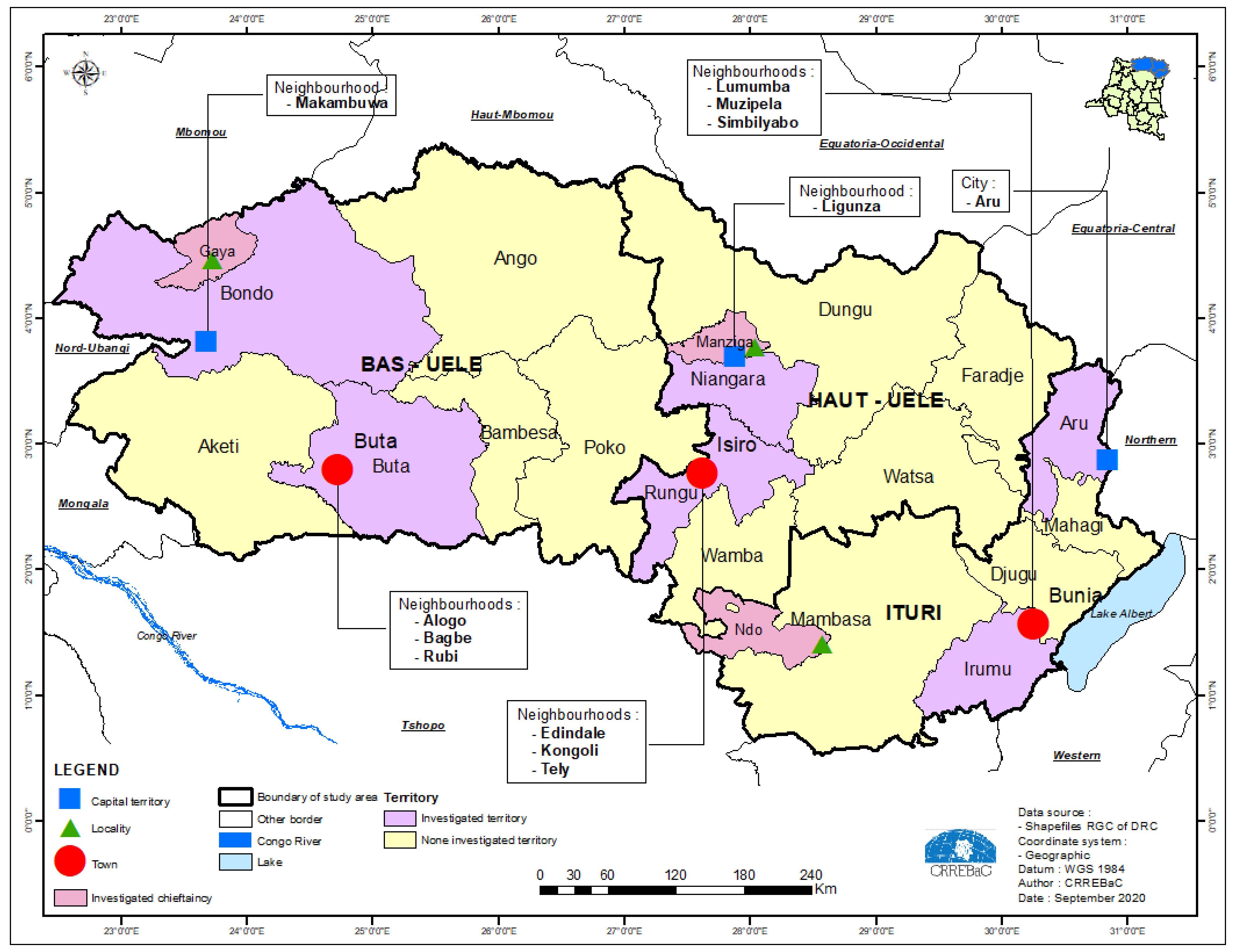
Due to limitations in time and technical resources, fieldwork and data collection campaigns focused on the first region of the study area (Zone I, Figure 1), in the northern part of the DRC. The data collection campaign was therefore a pivotal activity of this study, making it a full-fledged objective of data production. The three provinces identified in this study were subject to field investigations for the collection of data that was used for four levels of comparison (Figure 3, Table 1):
  • The first level of comparison relates to the three different provinces in the northeastern part of the DRC;
  • The second level of comparison involves urban, peri-urban and rural (cluster) environments in each of three provinces;
  • The third level of comparison concerns migration status;
  • The fourth level of comparison is gender-related.
Fieldwork campaigns took place from July to September 2019 and targeted collection of primary and secondary data on socio-economic and environmental impacts of migrations, impacts of climate change on water resources, different water uses and land use. On the ground we worked with a cultural mosaic with five major sociolinguistic groups: the Peuls (transhumants), the autochthonous peoples, Bantu, Sudanese and nilotics of various origins who have settled in the regions under the study, some for centuries, through trade, wars, colonization; and for others, recently, through migratory routes and population movements, in search of pastures, water resources related to climate change and safe land. The quantitative sample was drawn using the following six steps:
  • Visiting the cluster and numbering all households counted, using a count sheet, 1 to N (number of households);
  • Computing “R” for random sample, R = N/30 and we rounded to double digits after the comma;
  • Selecting a random number. To do this, a random number table at n digits (n being the number of values that constitute the entire part of R) is considered. The random number (T1 drawn indicates the ID number, sample number) in the survey base is the first sample unit (first household);
  • Selecting the other sample units on the basis of the “R” draw step by creating an arithmetic progression based on T1 and for R = N/30;
  • Setting survey numbers. This involves assigning a sequential number of 1 to n to all units held in the household;
  • Identifying units of the sample: for each unit we searched for the identifiers of the actors.
The research questions under investigation in this study have been the focus of several debates at regional and international levels for several decades, with the aim of developing appropriate strategies to strengthen communities’ resilience to the threats of climate change, migration and the various resulting conflicts (community conflicts and the environment). As a result, the data collection campaign noted active participation of stakeholders involved in climate change, water, migration and conflicts issues. We noted the involvement of communities’ elders, local elected members of the national assembly, the senate and the provincial assemblies, political-administrative authorities at the provincial and territorial capitals, customary authorities, religious and opinion leaders, members of women’s associations, representatives of vulnerable groups, representatives of migrants, members of civil society, groups of local leaders such as heads of streets, localities, groups, sectors, state service agents and households.
Overall, 1008 individuals participated in the investigation as shown in Table 1. Sampling and data collection indicate that 450 individuals responded to the quantitative questionnaire of our surveys. In addition, 248 people participated in the 51 focus groups and group discussions organized for this study with 6 to 12 people per group. Some 310 individuals, including 198 men and 112 women, were interviewed in semi-direct individual interviews.
For the qualitative part of the survey, organized mainly in focus groups, group discussions and semi-direct discussions, we addressed a selected audience according to specific criteria in order to record the opinions of key players on all the themes of the survey. During the investigations, the aim was to direct the selection of respondents according to the actors cited by first interviewees as resource persons. In each targeted province, respondents/households were divided into three clusters: urban, peri-urban and rural. For the quantitative part of the survey, the statistical unit was the household. Thus, the sample was drawn on three levels. In urban and suburban areas, municipalities were selected from which we randomly draw neighborhoods (quartiers) in the first degree and streets in the second-degree. In the third degree, 30 households per cluster were drawn from a systematic household count using a household count sheet. Here, the household refers to a group of persons, related or not, living in the same dwelling unit (or under the same roof), most often taking their meals together, supporting together their basic needs and generally recognizing within it the authority of a single person who acts as the head of the household. According to the study’s baseline terms, household observation units are all persons with a minimum age of at least 10 years old.
In rural areas, in the first degree, the territories were considered. In the second degree, we considered chiefdoms in each territory. In the third degree, villages were drawn from the chiefdoms. A systematic counting of the number of households in the village was more than 30. Otherwise, when households in a village were less than 30, we used the population census as a whole.
The sample for the collection of quantitative data at the household level in each province was carried out in three locations. For the province of Bas-Uélé, it was in the city of Buta, the capital of the province (urban); the city of Bondo, the capital of the territory (Periurban) and the village Baye, the capital of the Diadia grouping of the Gaya chiefdom (village). At the level of the province of Haut-Uélé, the investigation took place in the city of Isiro, the provincial capital; the city of Niangara, the capital of the Niangara Territory and the chiefdom of Manziga-Nambia. As for the province of Ituri, outside the city of Bunia, the provincial capital, data collection activities were organized in two territories: Mambasa and Aru. For the territory of Mambasa, at the level of the city of Mambasa, capital of the Territory and at the level of the chiefdom of Epulu. For the territory of Aru, the data collection focused on the villages Ndango and Ngabo of the Ndo Chiefdom of the Biringi Group.

3.4. Data Screening and Processing

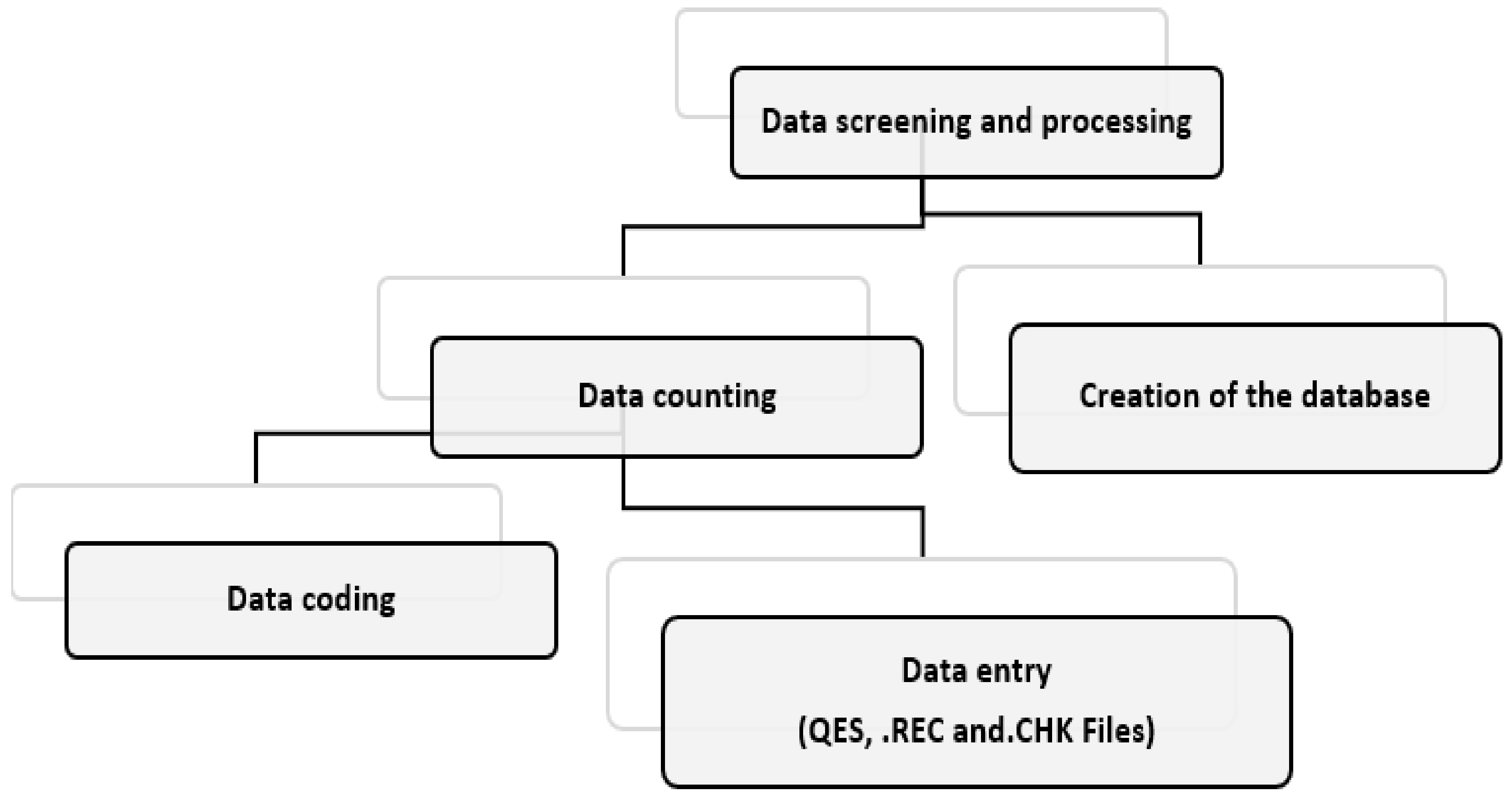
Figure 4 shows the steps used for data processing and analysis, which all led to building a dataset of the nexus on climate, water, migrations and conflicts in the Congo Basin. This database is further used to build an interactive interface to facilitate access to the information contained in the database.

3.4.1. Data Coding

Data coding consisted of transforming the data into a suitable format for computer aided analysis. It involved both quantitative and qualitative data, which were grouped into 15 thematic areas by assigning them an identification number.

3.4.2. Data Entry

From the coded data, three files were successively created using the EpiData entry function in EpiData 4.2, which is a software package created by epidemiologists [21,22]. These files include the questionnaire file, data file, and control file and recording file.
The questionnaire file is used to create the database questionnaire file that integrates the three important characteristics of each variable, namely the name of the variable, the label of the variable and the format of the variable. The questionnaire file created is known as .QES in the database. The data file is created automatically and by default has the same name as the questionnaire file (QES), but with the extension .REC, which means record. After naming the data file, a short description of the file is made; this is the data file label. This is useful in the documentation functions of the file and allows a brief description of the database.
The control file contains automatic control commands or restrictions needed in the data file. It has the extension .CHK, which means check. Some restrictions used to facilitate the use of this database are presented below:
  • Limiting the input of numbers to a given range or to a number of predefined values;
  • Make the entry of a variable mandatory;
  • Copy the contents of a variable from the previous record into the new record to be entered;
  • Create transition to other variables based on the content of the data entered;
  • Facilitate computation of variables based on the value of other variables;
  • Facilitate computation of complexes operations.
The recording file allows the data to be entered into the .REC file, precisely in the input fields corresponding to the variables or questions under consideration. The data were recorded in the .REC file continuously until the maximum number of records or observations was reached, i.e., 450 records. Data export can be done using dBase, Excel, Stata or SPSS formats.

3.4.3. Building the Database

The database on the Climate-Water-Migration-Conflict nexus (CEMiC) was created on the EpiData software when the data is exported in the Sav. format of the SPSS software (Statiscal Package Social Science). After the creation of this database, a thorough cleaning was carried out in each observation with the aim of correcting and recoding the outliers. The database is built using the SPSS software package, which helps to clean the database from errors and also ensures data display.

3.4.4. Transformation of the Database from SPSS into an Interactive Data Visualisation Interface

A combination of previous steps has led to establish an integrated information system. This process of setting up the information system was carried out in several stages, including construction of a structure that consists of the hierarchical organization of the research themes, variables and response modes, and creation of the variable description form that provides a summary description about the variable. An example case of the form is given in Figure 5.

4. Database Architecture and Information System on Climate-Water-Migrations-Conflicts (CEMiC)

The field investigation and data processing carried out in this study have led to building the database and information system that are presented in the following sections.

4.1. Data Types, Variables and Thematic Areas

The types of data contained in the CEMiC database covers the following information:
  • Migration statistics;
  • Vital statistics in relation to the different segments of the populations constituting each “local community”;
  • The actors, stakes and capacities of influence (powers: formal, informal and spiritual) upon each other;
  • Strategies (mobilized social intelligence);
  • The norms involved (cultural factors, customs and traditions, state laws, social practices put in place by actors, etc.);
  • Statistics of human groups, livestock and land tenure;
  • Local evidence of climate variability (images, units of measurements, local concepts, actors, durations of climatic seasons, flood levels, and regularity or irregularity of precipitation) and the links between climatic factors-migratory pressures-the availability or unavailability of water resources, the nature and types of violence and conflicts associated with them, and the mechanisms of resilience of communities;
  • The perception of population, involving men, women and children on migrants and climate change;
  • The experience of migrants themselves in transhumance, migration routes, cultural and natural realities encountered in transit and reception places;
  • Differences constructed in the socio-cultural context of the Congolese, particularly in the provinces under study, including how conceptions and forms of masculinity/femininity facilitate or hinder gender equity in various areas of the country’s development;
  • Shared views, different points of view.
  • Two criteria are used for the classification of the data types, including aggregation and the scale of measurement. Aggregation of variables consisted of compiling information contained in the database with the aim to constitute ensembles of data for data analysis [23]. The individual variables, also called disaggregated variables, contain the statistical characteristics of these ensembles. From a scale of measurement point of view, the variables are either qualitative or quantitative. Therefore, the disaggregated variables refer to the statistical nature of the variables which are quantitative or qualitative; nominal, ordinal, discrete or continuous.
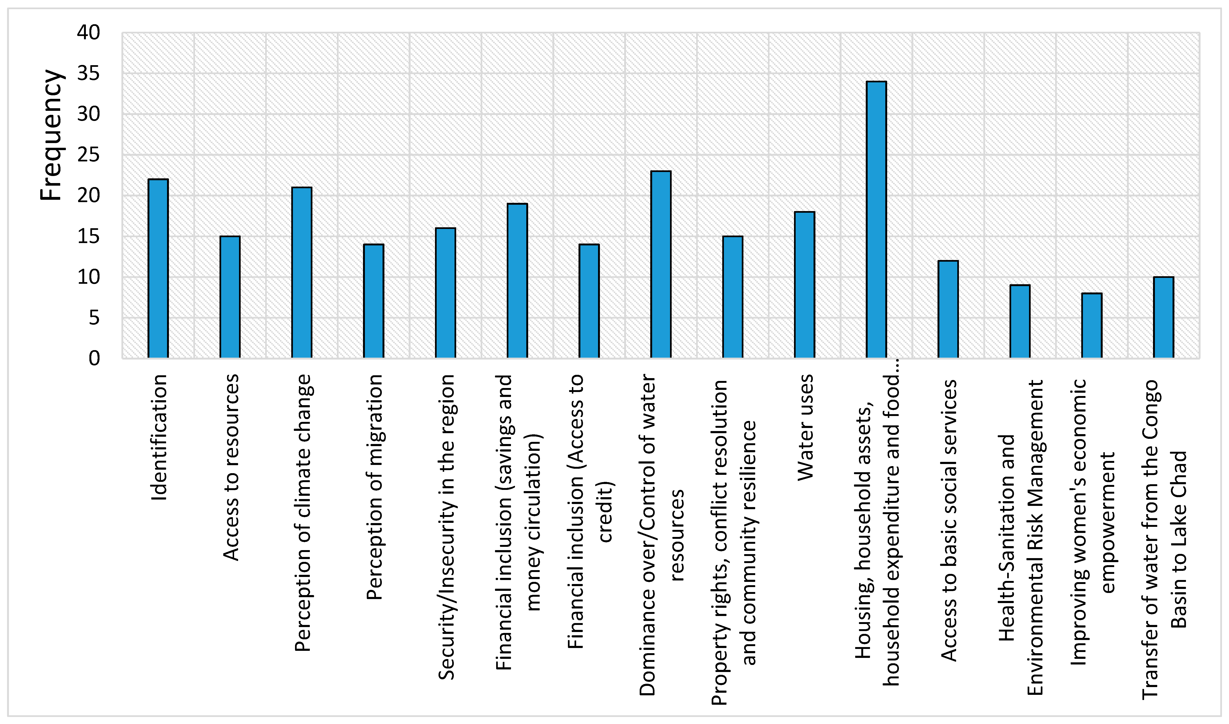
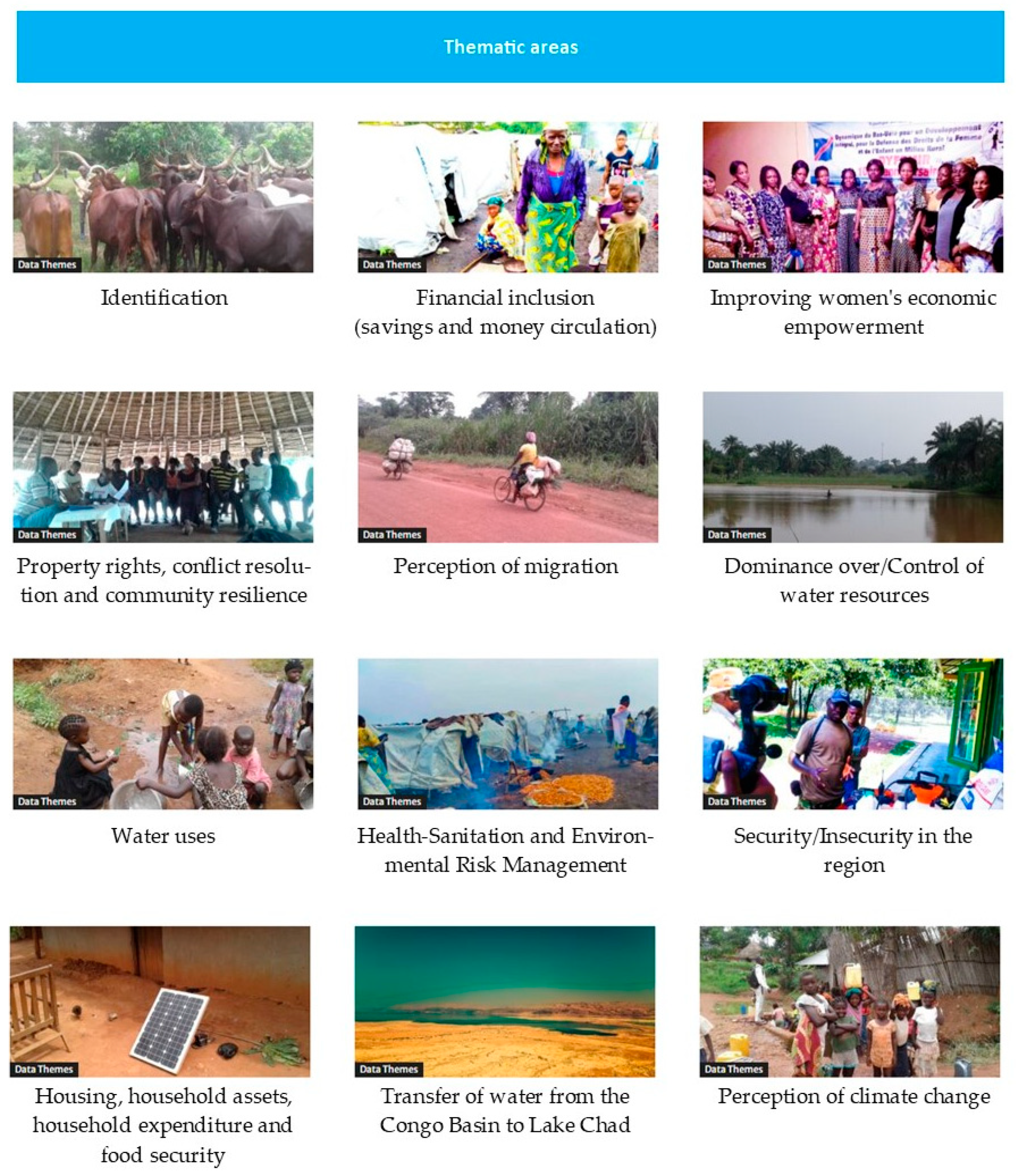
Overall, 250 aggregated variables including 575 individual variables (disaggregated) have been grouped around 15 thematic areas, which are used to build the database of Climate-Water-Migration-Conflict nexus in the Congo Basin. These 15 thematic areas constitute the main core of the CEMiC database, they are presented and briefly discussed below. Figure 6 presents the 15 thematic areas and 18 aggregated variables that illustrate the content of the water use theme. The frequency of variables per category of thematic area is presented in Figure 7.
Identification elements: The focus of this thematic area is the identification data or social characteristics for people or communities under investigation. Information contained in this thematic area includes the profile of the respondents that was determined by age, gender of the head of household and of the respondent, marital status, place of birth, residence time of people in the community, level of education, religious affiliation, ethnicity, household size and occupation. For instance, most of the households surveyed (69%) are headed by a man, with an average household size of seven persons. The population of the provinces surveyed is predominantly young, with 73.3% under the age of 50. Age is a very important variable in the migration process and subsistence activities. Life cycle theory indicates that people do not migrate at all ages; on the contrary, there are ages at which the propensity to migrate is very high, notably the ages of access to school, employment and marriage, and others at which it is very low. Agriculture is the main activity of 90% of the heads of households surveyed.
Access to resources: Agro-pastoral production is one of several key activities in several tropical regions. Its profitability is highly dependent on the possibility of accessing other resources such as land and water as well as other technical resources including credit facilities, training, information and technical input such as seeds, tools, fertilizers, pesticides, etc. Access to these resources is therefore essential for the population as they significantly contribute to satisfying multiple needs [24]. The thematic area on access to resources provides information that highlight the state of socio-economic factors that determine the vulnerability of the population living in the study area [9]. For instance, it is established that two-thirds of households in the study area obtain their water from undeveloped springs, streams or unprotected wells. The inadequacy of water and sanitation infrastructures encourages the spread of infectious diseases, especially diarrheal diseases, which are one of the major causes of malnutrition. The same is true for the level of access to electricity which is a necessary criterion for assessing the level of development in an area. In the north-eastern region of the DRC, access to electricity is not secured for the vast majority of the population.
This thematic area also provides information on pressure and threats from anthropogenic activities on biodiversity, including armed groups, mining, poaching, slash-and-burn agriculture, illegal farms and camps, less sustainable fishing, and transhumance by Mbororo herders.
Perception of migration: The recent surge in cross-border migration in the north-eastern region of the DRC is of great concern to the local and national governments of the country as well as to the local communities—noting the negative impacts on social stability, as well as on the security situation, as local and sub-regional conflicts become more widespread [6,9]. It is necessary to have the perception of the populations affected by these emerging new trends of migrations in the region. The type of information provided under this thematic area highlights the insertion of migrants in the local communities and the reasons for migration that help identify different groups of migrants.
Vulnerability to climate change: Risk assessment is necessary to identify exposures and vulnerabilities to climate shocks in a given region, so it is necessary to assess the factors and possible changes that affect communities, their livelihoods and assets. It is also about understanding the existing resilience capacities, in other words, the factors that enable communities to cope effectively with climate risks. In Uganda for instance, the use of locally relevant information on climate change adaptation resulted in a 67% reduction ($226 to $325 per household per year) in crop losses and damage in the intervention districts compared to the control district. Climate information contributes to decision making and sharing of good agricultural practices. It also enables the dissemination of resilience actions to cope with climate shocks [25]. The CEMiC database highlights the state of access to information and resilient strategies to climate change, thus providing diversification measures that are necessary to strengthen community resilience to climate change [26,27,28,29].
Property rights, conflict resolution and community resilience: Multiple conflicts have emerged in the north-eastern part of the Congo Basin, the most recurrent of which are those related to conflicts between displaced peoples and the residents, and conflicts between farmers and pastoralists [30,31]. In the first case, land is sometimes inappropriately occupied without taking into account the rights of the displaced or residents [10]. In the second case, areas of land that used to be occupied by farmers have become preferred areas for the development of pastoralism. This situation prevents both sides from benefiting from these areas and also creates conflicts. Resolving these land conflicts is clearly a major task [32]. This requires special attention to find appropriate solutions based on local, provincial and national strategies to strengthen the resilience of local communities, which are already facing armed conflicts. The implementation of alternative conflict management mechanisms linked to pastoral resources (mediation prior to formal justice) could prove to be very relevant.
Perception of climate change: The local climate conditions affect the basic socio-economic way of life of the populations who live essentially from natural resources and whose mode of exploitation is based on the seasonal distribution of climatic variables. Several studies [33,34,35] highlight that small-scale producers and poor rural populations in developing countries are particularly vulnerable to the impacts of climate variability and change, mainly due to non-resilient and insufficiently diversified production systems, which also complicate the adoption of practices that are supposed to go hand in hand with effective climate change adaptation and mitigation measures.
The history of the ethnic groups settled in the North-East of the DRC reveals a subsistence mode based on rain-fed agriculture, hunting, gathering and fishing. The relationship between these human subsistence activities and rainfall is a matter of adequate know-how to cope with rainy conditions in the rainforest, a legacy that has been passed down through many generations. It is therefore relevant to analyse the perceptions of this population in order to bring out the tangible evidence of climate change on the activities of the population, including their endogenous knowledge, which can lead to an adapted action plan that integrates the evidence based on the perceptions of this population.
In this regard, the CEMiC database provides information on the disruption of seasonality, particularly irregular and very intense rains, which have repercussions on socio-economic life, with the agricultural sector being the most affected. The late start and poor distribution of the rains alter the agricultural calendar, and farmers no longer know how to orientate sowing and harvesting. Low agricultural production is the greatest manifestation of climate change in women’s activities in the study area. Climate change jeopardises the achievement of women’s goals in terms of their annual production and the perceived impact on their socio-economic empowerment.
Financial inclusion (savings, access to credit and circulation of money): Climate change and insecurity have been identified as the main cause of migration within the region, thus leading the mass movement of the Mbororo pastoralist communities to the north-eastern region of the DRC [36,37]. It should be noted that there are many other financial activities at stake that are linked to the current trend of the Mbororo phenomenon which involve several groups of stakeholders in the informal economy. This informal economy encompasses the use of natural resources such as minerals, wildlife products and flora, all of which are centered around the cover of “cow species”. In addition, there is a transhumance economy based on the trade in transhumant animals [33]. One of the interesting avenues of research opened up by this study is the identification and understanding of the chains of money movement from this informal economy.
One of the interesting avenues of research opened up by the study on the Climate-Water-Migration-Conflict nexus remains the identification and understanding of the circuits of circulation of money from this unformal economy. The presence of Mbororo herders in the north-eastern part of the DRC is justified on the one hand by the presence of a large hydrographic network that irrigates the forest and savannah ecosystems of the Bili-Uéré Hunting Estate and Bomu Wildlife Reserve [38] and on the other hand, by the security and climatic challenges faced by the countries of origin of the Mbororo [36,37,39,40]. However, the existence in the DRC of an important market for the sale of transhumance animals is seen as one of the major motivations for the presence of the Mbororo in the DRC, which is currently considered to be an emerging destination for the transhumance economy of the Mbororo in the Congo Basin. The authors of [41] raised several questions about the dynamics of beef marketing in Mali during the closure of the Senegalese and Ivorian borders at the time of political events. Similarly, multiple attacks by negative forces in the Lake Chad region have exacerbated the vulnerability of livestock market behaviour and encouraged Mbororo herders to explore the Congo Basin. The analysis of the modus operandi of transhumance as described during interviews with state services and civil society in the study area present the availability of the cattle market as the main reason for Mbororo transhumance in the north-eastern part of the DRC. In analysing the realities and prospects of the livestock trade in Central Africa, [42] states that: “The savannahs of Central Africa have long been considered as exclusively cotton-growing areas, particularly in Chad and the Central African Republic”. However, over the past 30 years, pastoral livestock farming has emerged in southern Chad and northern CAR. The savannahs have become regions producing cattle for export. In addition to the traditional flows to Bangui, Congo and southern Cameroon, a new export circuit has emerged linking southern Chad to Nigeria. It is controlled by networks of Arab and Fulani traders. This new export circuit drains about 170,000 head per year from livestock markets located mostly in the Moyen-Chari (Chad). To date, live cattle have become Chad’s most important export product, accounting for 51% of the total value of exports. The efficiency of the trading networks is explained by a complex traditional organisation in which commercial functions are divided between several complementary actors: traders, associates, guarantors, brokers, forwarders, etc.
Water uses: Despite its abundant freshwater resources, the DRC faces the challenge of managing these resources to meet competing needs for economic and social development. It should be noted that only 4% of this potential is currently mobilized for multiple uses including agriculture, pastoralism, domestic use, etc. The assessment of current and future water uses under climate change context and competing interests in the region is of paramount importance. The need to address the challenges associated with the implementation of IWRM (Integrated Water Resources Management) is also a priority [43]. The CEMiC databse provides information on water use that should contribute to water security in the region. Sadoff and Muller [44] note that water security is central to climate change adaptation.
Housing, household assets and household expenditure: The migration observed in the north-eastern part of the DRC is not without consequences, as it contributes to the deterioration of socio-economic factors in this region. It was therefore useful in the context of this study to better understand the links between livelihood assets and the mechanisms put in place to deal with the deterioration of living conditions.
The database provides information on three levels of assessment of housing, namely: precarious housing, acceptable housing and comfortable housing, which reflects the state of poverty in the study area.
Food security: Households are food secure when they are able to obtain the necessary amount of safe, diverse and year-round food for their family members to lead a healthy and active life. Food security is defined as the ability to obtain enough food to meet the dietary needs of all family members, either from individual production or through purchases. The food security vulnerability cell [45] highlighted the fact that of the 22 countries in the world considered to be in acute food crisis, 17 are in Africa. Of these countries, Chad, Côte d’Ivoire, the Democratic Republic of Congo (DRC), Ethiopia and Zimbabwe were identified as highly vulnerable areas, accounting for almost 64% of the total undernourished population in African countries. It was therefore important for this study to take stock of the population’s vulnerability to food insecurity, as food security is a key indicator in assessing the adaptive capacity of populations.
The database highlights information on food consumption scores, calculated according to the World Food Programme method and based on dietary diversity, frequency of consumption and relative nutrient intake of different food groups. The information contained in the database can be used to lead multi-sectoral interventions to reduce the prevalence of food insecurity [46].
Water-Hygiene-Sanitation: A diagnostic analysis of the water, hygiene and sanitation sector reveals that water security in the DRC is a challenge and there is low access of population to improved water and sanitation services. This situation increases the vulnerability of the population.
Dominance and control over water resources: Water resources are never simply there; they are produced by social and political systems. Water resources are the product of history; water systems are not only shaped by, but also shape social and political relations [9]. Diverse ranges of social and political institutions and formal and informal institutions govern the use, access and control of water at a range of different scales. Cultural systems and traditions that contribute to conservation of water and related resources are rooted in customs, beliefs and values of local people. They have played and will continue to play a prominent role in protecting water resources. Conflicts over water are not new around the world, but in the last two decades they have had a sharp rise. In the Congo Basin, the theory of water war is the focus of many debates [12]. Water resources are therefore a determining factor as the availability and accessibility of water resources is a limiting factor for development.
Environmental risk management: Large-scale intervention mechanisms, including participatory approaches to awareness raising, security and biodiversity protection are the local initiatives that are considered affordable and effective in managing environmental risks related to migratory movements in the study area. This theme has therefore been prepared to highlight initiatives that are resilient to the climate-water-migration-conflict causal complex.
Large-scale intervention mechanisms, including participatory approaches to awareness raising, security and biodiversity protection, are the local initiatives deemed affordable and effective in managing environmental risks related to migratory movements in the study area. This theme provides information that point to initiatives that are resilient to the Climate-Water-Migration-Conflict causal complex.
Anthropogenic activities can be intentional targets of environmental change and can be subject to feedback in terms of environmental change; they can be intentional or “by-products” of other human activities. The CEMiC database points to evidence of anthropogenic activities including poaching, illegal exploitation of natural resources and water pollution that constitute major environmental risks (potential and actual impacts) caused by the transhumance of Mbororo herders in the north-eastern part of the DRC. Protected area managers claim that these impacts are becoming increasingly important in the study area.
The massive presence of Mbororo zebu herds in the protected areas exerts a significant pressure on biodiversity, ranging from encroachment to pollution of watercourses. The various threats and pressures experienced by the protected areas in the study area also stem from the illegal exploitation of natural resources, the weakness of the regulatory, institutional and operational framework (governance) and the limited number of partners. In addition, the installation of Mbororo herders in the protected areas and the territorial administration at the local level causes repercussions on the biological diversity of both plants and animals in the region, which does not spare the ecosystem services that would be closely linked to biodiversity, and influences the ecological integrity of the protected areas by breaking the balance between the elements of nature.
In addition, the human, logistical and financial means to ensure the efficient management of biodiversity in these protected areas, which are supposed to be little disturbed, are limited. This justifies the presence of several militias in the protected areas, including transhumant Mbororo herders, who justify the use of firearms for the security of their herds, sometimes eliminating certain emblematic species (lion, leopard, elephant, Sitatunga, etc.).
To manage these environmental risks, the information highlighted in the CEMiC database relates to local (based on indigenous knowledge), national and even regional initiatives and strategies that provide opportunities to improve human well-being and reduce human and environmental vulnerability [47]. This information is effective when undertaken in a forward-looking manner and focuses holistically on four priority dimensions: legal and institutional; social based on infrastructure development; technical and operational; and research and development. National policies based on indigenous knowledge and supported by international agreements and conventions on biodiversity management as well as management capacity building provide opportunities to enhance and protect biodiversity and ecosystem services provided by protected areas [48,49,50,51].
Enhancing women’s economic empowerment: In general, women face serious difficulties of access to available resources, including restricted rights and reduced mobility and participation in decision-making, which make them vulnerable to climate change, exacerbating the already existing inequalities [32]. Gender equality and women’s empowerment are important aspects for reducing inequalities within communities [52].
The CEMiC database highlights information related to the dependence of women on natural resources and rainfed agriculture. The relevance of this type of information has been demonstrated in scientific literature, notably the National Network of Rural Women of Senegal [53] which stated that ‘rural women are closely dependent on natural resources for the survival of their households’.
Although endowed with exceptionally abundant natural resources, the DRC has not been able to transform this potential into wealth. Its population, particularly the female, lives in poverty. This paradox was demonstrated in the study of Climate-Water-Migration-Conflict nexus in the Congo Basin, which shows that hydro-climatic dynamics combined with migratory pressures on resources accentuate social precariousness, particularly that of women [32].
In addition, the database points to inequalities between women and men that affect all sectors of life, particularly from access to resources to decision-making. These inequalities are a major socio-economic determinant for the development of the local communities [54,55] emphasize the need for information and actions to improve women’s representation in decision-making and to increase their financial and physical assets in order to enable them not only to be financially self-sufficient, but more importantly to provide them with better access to decent employment, higher wages, better career opportunities and to compete.
Water transferfrom the Congo Basin to Lake Chad: The ambitious proposal to transfer water from the Congo Basin to Lake Chad has allowed the theory of water war to build up [56]. It is true that in principle, the Congo Basin countries as a whole have a high-water resource potential compared to other African countries, which could support regional cooperation in the management of shared water systems, but there is a very low level of access to water services such as drinking water, sanitation and food security in these countries, particularly in the DRC. This is largely due to lack of infrastructure, weak technical and human capacities and poor governance, which result in little or no social resilience to cope with the unforeseen effects of climate change and its socio-economic and ecological consequences.
The dynamics of hydro-climatic variability in Lake Chad is a historical phenomenon that has been fluctuating for centuries and continues to do so. This phenomenon has unfortunately been amplified by demographic pressure and irrational management of the natural resources available in the Lake Chad Basin. From this, analysists observe that the inter-basin water transfer initiative should not be directly linked to the dynamics of climate variability and change in the region [7,8,16]. Margin points to a deliberate intention to use scientists to support an alarmist trend of the disappearance of Lake Chad. Scientists, analysts and political actors in the DRC and Congo Basin countries oppose this initiative of the inter-basin water transfer on the basis of territorial sovereignty, the large-scale impacts it would have in terms of loss of forest ecosystems and biodiversity, protected and existing World Heritage areas, displacement of human populations, destabilization of the Congo River flow and river sedimentation, proliferation of invasive species between Lake Chad and the Congo Basin, impacts on the future of the Inga hydro-electric sites, etc. Congolese analysts also argue that solving the problem in Lake Chad only possibly creates another problem in the Congo Basin. They stress that that the migrations currently observed in the north-eastern part of the DRC and the ambitious proposals to transfer water from the Congo Basin to the Lake Chad Basin are likely to amplify the vulnerability of communities already living with the effects of climate change exacerbated by decades of armed conflicts.
The CEMiC database provides opinions of stakeholders on the opportunities and threats that would result from the inter-basin water transfer initiative.
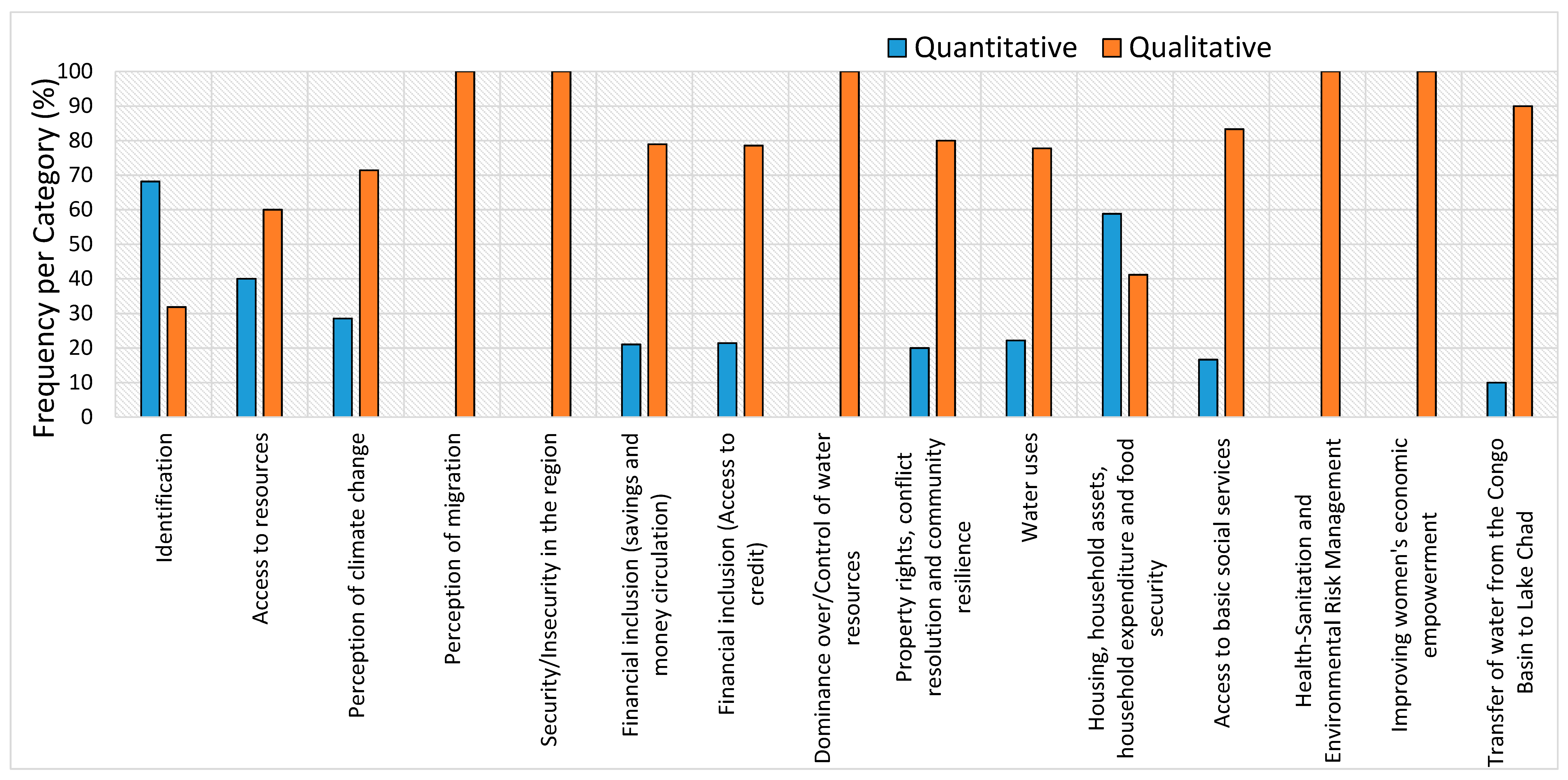
Figure 8 presents the types of disaggregated variables for the thematic area on access to water resources. The relative frequency per category of quantitative and qualitative variables (Figure 9) and nominal, ordinal, discrete and continuous (Figure 10) are also presented. Overall, it comes out that the distribution of the statistical characteristics of the database is dominated by the qualitative and nominal variables that represent 77.6% and 73.6% respectively, whereas the range of the other statistical characteristics includes 22.4% of quantitative variables, 4% of ordinal variables, 16.4% of discrete variables and 6% of continuous variables. The spread of these statistical characteristics also shows the variability of the information content in the database.

4.2. Open Access Integrated Information System and Functionalities

An operational and publicly accessible web interface of the Climate-Water-Migration-Conflict nexus information system is of paramount importance as it fosters enhanced collaboration, and improves knowledge sharing between researchers, policy makers and communities in the Congo Basin on human-environment interactions. The need for such an information system has already been stressed in the many studies that tended to address the interlinkages between climate-water-migration-conflicts in the region of central Africa [43].
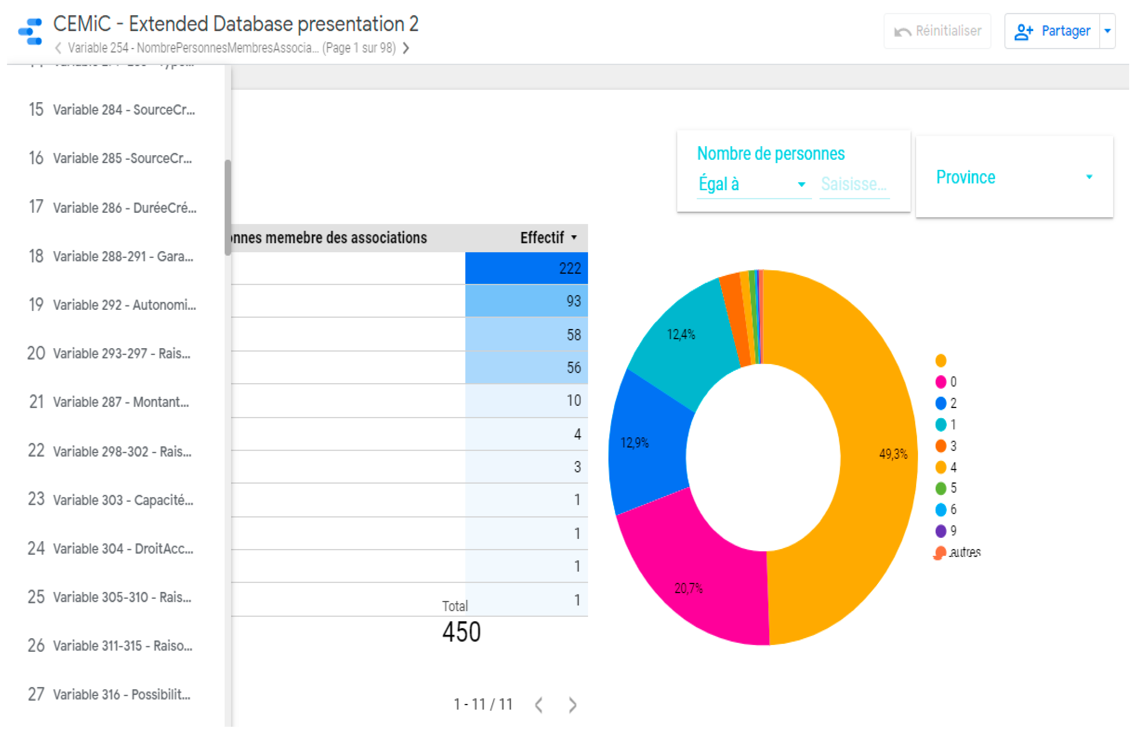
The database Climate-Water-Migration-Conflict nexus of 15 thematic areas and 250 variables is used to develop this knowledge-based interface that allows stakeholders to easily access information (Figure 11), with 450 samples for the three provinces investigated, 150 each. The interface is built with the aim of providing users with an intuitive navigation of information. It has two functions, notably to present information in a simple way; and to promote the value of the information for users, facilitate information update, inform about the flow statistics of users and their needs and facilitate dialogue and feedback between the users and the investigators. The tools used to build the database include:
  • An online spreadsheet (Google Sheet) that allows data storage and correction of possible encoding during processing.
  • An online tool for converting data into customizable informative reports and tables (Data Studio), which is used to produce the tables, graphs and filtering tools.
  • A content Management System (Wordpress), known as one of the most effective tools for search engine optimization. It is used for the design and dynamic updating of websites or multimedia applications. A website dedicated to the presentation of data has been set up with the Wordpress tool connected to Data Studio.
The operational and publicly accessible web interface of the Climate-Water-Migration-Conflict nexus information system has three levels of navigation, namely a home page, a theme display and a variable display. The different functionalities are summarized below.
  • Home page: The home page is the link between the information system and visitors or users. Its purpose is to provide visitors or users with intuitive navigation of the platform’s data. It therefore has two essential functions, namely to clearly present and enhance the platform through various data updates and to direct the flow of visitors. It displays the list of themes in a structured way.
  • Display of themes: The themes are organized in the second place, and each contains a list of variables. Each theme is described in a summarised way to allow visitors or users to get a feel for the content. Fifteen themes have been structured in this platform, each containing variables.
  • Display of variables: The variable is the last unit of presentation in the information system and is presented in two ways, namely tabular and graphical. In the presentation of the variable, two navigation possibilities are made available to the user, namely navigation by province and navigation by locality. Two key pieces of information are also highlighted for each variable, namely the response modalities and the numbers (for the table) or percentages (for the graph). For every variable, a table and a graphic can be displayed, and the filter tools are used to facilitate navigation based on the three administrative boundaries, the territories or localities (Figure 12). The user will also find two filters next to the variable for downloading data in CSV format and for redirecting to appendix data (focus group and semi-structured interview transcript sheets) to the variable in word or pdf format.

5. Conclusions and Way Forwards

Human-environment interaction constitutes a critical issue under the current context of climate change, but there is always a lack of information at the appropriate scale of decision making to effectively address the issue. The lack of information on the current state of the climate and natural resources at different scales in the Congo Basin, and on how their dynamics will change in the future in response to changing environmental conditions (climate change and land use), represents a bottleneck for sustainable planning. A critical lack of technical resources and the institutional challenges undermine the ability to implement strategies to ensure resilient development. This study carried out in the Congo Basin to address climate- and water-driven migration and conflict interlinkages to build community resilience enabled the development of an information system that results from the application of a rigorous and multidisciplinary methodological approach. This approach consisted of designing appropriate tools for field survey and data production, creating a statistical database and creating a web interface with the aim to make this information system publicly available for users and stakeholders.
The information system developed is a structured and organized set of quantitative and qualitative data on the climate-water-migration-conflict and gender nexus, consisting of primary data collected during field surveys. It contains 250 aggregated variables or 575 disaggregated variables, all grouped into 15 thematic areas, including identification; socio-demographic characteristics; access to resources; perception of climate change; perception of migration; financial inclusion (savings, access to credit and circulation of money); domination and control of water resources, land ownership and property rights, conflict resolution and community resilience; water use; vulnerability to climate change; housing, household assets, household expenditure; food security; health, hygiene and sanitation; environmental risk management; women’s economic autonomy; and water transfer from the Congo Basin to Lake Chad.
The use of this this information system will help achieve the following goals:
  • Provide practical knowledge for decision makers and other stakeholders, along with enhanced understanding of the vulnerabilities, exposures and risks as well as participatory design of long-term investment and development strategies;
  • Strengthen collaboration and experience sharing in the Congo Basin through interactions between researchers, policy makers, communities and other stakeholders;
  • Contribute to the capacity building of stakeholders on emerging issues addressed by climate-water-migration-conflict nexus in the Congo Basin;
  • Support policy and decision makers in the formulation and implementation of smart solutions to the impacts of climate change and the water crisis in the Congo Basin, with particular attention to the impacts of migration and conflict;
  • Support key policy areas and strategies to foster effective stakeholder participation to ensure the management and governance of climate and natural resources, and gender consideration in all aspects, both at national, basin and regional levels;
  • Strengthen political commitment to support climate resilient development in the Congo Basin;
  • Support of the implementation of Sustainable Development Goals (SGDs), and help strengthen the capacity of local communities, empower women and benefit youth through insights for income and livelihood diversification activities.
It should be noted that the work carried out in this study singled out a hotspot area of climate- and water-driven migration and conflicts in the Congo Basin, but it is not sufficient to represent the all geographical, physiographical and sociological domains in the Congo Basin. Undertaking such a study in the other areas of the Congo Basin region that represent different conditions will enrich the information system and benefit the purpose of cross-fertilisation of knowledge. The current work has also enabled the development of the first phase of the infrastructure of the information system, which will require feedback from users for future improvement to meet their needs.

Author Contributions

Conceptualization, R.M.T. and G.-S.K.L.; methodology, R.M.T., M.K.B., E.-T.N.M., J.-F.K.N., G.M.S., J.T.B. and A.L.L.; software, N.K.K., C.M.S., L.N.N., G.M.S. and N.M.N.; validation, M.K.B. and B.M.L.; formal analysis, R.M.T., G.-S.K.L., E.-T.N.M., J.-F.K.N., L.N.N. and G.M.S.; investigation, R.M.T., G.-S.K.L., E.-T.N.M., J.-F.K.N., L.N.N., G.M.S., J.T.B., A.M.K., L.M.B., A.L.L., N.M.N. and Y.B.Y.; data curation, C.M.S., G.M.S., A.M.K., L.M.B., A.L.L., P.Z.S. and Y.B.Y.; writing—original draft preparation, R.M.T. and G.-S.K.L.; writing—review and editing, R.M.T. and N.K.K.; visualization, N.K.K., C.M.S. and L.N.N.; supervision, B.M.L.; project administration, E.-T.N.M., J.-F.K.N. and L.M.B.; funding acquisition, R.M.T. All authors have read and agreed to the published version of the manuscript.

Funding

This Study was funded by the International Development Research Centre -IDRC, Canada. Grant No 108976-001. The views expressed do not necessarily represent those of IDRC or its Board of Governors.

Institutional Review Board Statement

Not applicable.

Informed Consent Statement

Not applicable.

Data Availability Statement

The open access infrastructure is under development. Data can be accessed through a temporary link on CRREBaC website: https://www.crrebac.org/projet-climat-eau-migration-conflit or on request at [email protected]; accessed on 1 April 2021.

Acknowledgments

This study was carried out by the Congo Basin Water Resources Research Center—CRREBaC in collaboration with the United Nations University-Institute for Water Environment and Health (UNU-INWEH), with financial support from the International Development Research Centre—IDRC of Canada for the project entitled: “Addressing climate- and water-driven migration and conflict interlinkages to build Community Resilience in the Congo Basin”.

Conflicts of Interest

The authors declare no conflict of interest.

References

  1. Trigg, M.A.; Tshimanga, R.M. Capacity Building in the Congo Basin: Rich Resources Requiring Sustainable Development. One Earth 2020, 2, 207–210. [Google Scholar] [CrossRef]
  2. Tshimanga, R.; Alsdorf, D.; Laraque, A.; Hughes, D.; Gulemvuga, G.; Mahe, G. Hydrology of Large Rivers: The Congo River Basin. In Handbook of Applied Hydrology; Singh, V., Ed.; McGraw-Hill Education: New York, NY, USA, 2016; ISBN 9780071835091. [Google Scholar]
  3. Tshimanga, R.M.; Hughes, D. Climate change and impacts on the hydrology of the Congo Basin: The case of the northern sub-basins of the Oubangui and Sangha Rivers. Phys. Chem. Earth 2012, 50–52, 72–83. [Google Scholar] [CrossRef]
  4. Molua, E.L. Reappraisal of the Climate Change Challenge in the Congo Basin and Implications for the Cost of Adaptation. Environ. Nat. Resour. Res. 2015, 5, 80. [Google Scholar] [CrossRef] [Green Version]
  5. OCHA (Office for the Coordination of Humanitarian Affairs). RD Congo: Plan de Remponse Humanitaire en Chiffres. 2020. Available online: https://www.unocha.org/drc (accessed on 1 April 2021).
  6. Kabamba, M. Les Migrants Climatiques En Quête D’adaptation: Les Éleveurs Mbororo Émmigrent en RD Congo. In Inégalité et Changement Climatique, Perspectives du Sud; Delgado-Ramos, G.C., Ed.; CODESRIA: Dakar, Sénégal, 2015. [Google Scholar]
  7. Magrin, G. The disappearance of Lake Chad: History of a Mythe. J. Political Ecol. 2016, 23, 204–222. [Google Scholar] [CrossRef] [Green Version]
  8. Lemoalle, J. Les Différents États du Lac Tchad, un Perpétuel Changement. In Atlas du lac Tchad; Magrin, G., Lemoalle, J., Pourtier, R., Eds.; Passages, Numero Spécial 183; IRD: Montpellier, France, 2015; pp. 23–27. [Google Scholar]
  9. UNEP. Water Issues in the Democratic Republic of the Congo: Challenges and Opportunities; United Nations Environment Programme: Nairobi, Kenya, 2011; Available online: https://wedocs.unep.org/20.500.11822/22067 (accessed on 1 April 2021).
  10. Africaine Union. Report on the Migrations of Mbororo Nomadic Pastoralists by the Fact-Finding Mission Dispatched to the Democratic Republic of Congo, the Central African Republic and Cameroon, Pursuant to Decision PSC/PR/COMM (XCVII). In Proceedings of the 97th Meeting of the Peace and Security, Addis Ababa, Ethiopia, 25 October 2007. [Google Scholar]
  11. Sayan, R.C.; Nagabhatla, N.; Ekwuribe, M. Soft power, discourse coalitions, and the proposed interbasin. Water Altern. 2020, 13, 752–778. [Google Scholar]
  12. Mutinga, M. La Guerre de l’eau aux Portes de la RDC. In Le Fleuve Congo et ses Affluents: Un Château d’eau Convoité; Le Potentiel: Kinshasa, Congo, 2014. [Google Scholar]
  13. Tshimanga, R.M.; Trigg, M.A.; Neal, J.; Ndomba, P.; Hughes, D.A.; Carr, A.B.; Kabuya, P.M.; Bola, G.B.; Mushi, C.A.; Beya, J.T.; et al. New Measurements of Water Dynamics and Sediment Transport Along the Middle Reach of the Congo River and the Kasai Tributary. In Congo Basin Hydrology, Climate, and Biogeochemistry: A Foundation for the Future, 1st ed.; Geophysical Monograph 269; John Wiley & Sons, Inc.: Washington, DC, USA, 2021; ISBN 9781119656975. [Google Scholar]
  14. Tshimanga, R.; Bola, G.; Kabuya, P.; Nkaba, L.; Neal, J.; Hawker, L.; Trigg, A.M.; Bates, P.; Hughes, A.; Laraque, A.; et al. Towards a Framework of Catchment Classification for Hydrologic Predictions and Water Resources Management in the Ungauged Basin of the Congo River: An a Priori Approach. In Congo Basin Hydrology, Climate, and Biogeochemistry: A Foundation for the Future, 1st ed.; Geophysical Monograph 269; John Wiley & Sons, Inc.: Washington, DC, USA, 2021; ISBN 9781119656975. [Google Scholar]
  15. Omasombo, T. Haut-Uélé: Trésor Touristique. In Monographies des Provinces de la République Démocratique du Congo; Le Cri-MRAC: Bruxelles-Tervuren, Belgium, 2011; Volume 2, p. 440. [Google Scholar]
  16. Omasombo, T. Bas-Uélé. In Pouvoirs Locaux et Économie Agricole: Héritages d’un Passé Brouillé; Le Cri-MRAC: Bruxelles-Tervuren, Belgium, 2014. [Google Scholar]
  17. Kiari, F.H. Impacts des Variations du Niveau du lac Tchad sur Les Activités Socio-Économiques des Pêcheurs de la Partie Nigérienne. Ph.D. Thesis, Université Abdou Moumouni de Niamey, Niamey, Niger, 2014. [Google Scholar]
  18. Réounodji, F. Conséquences de la Sécheresse sur les Activités Humaines: Les Exemples de Karal et de Guitté au sud du lac Tchad. Rev. Sci. Tchad. 1995, IV, 59–69. [Google Scholar]
  19. Magrin, G. Crise climatique et mutations de l’agriculture: L’émergence d’un grenier céréalier entre Tchad et Chari. Ann. Geogr. 1996, 592, 620–644. [Google Scholar] [CrossRef]
  20. Sarch, M.T.; Birkett, C. Fishing and farming at Lake Chad: Responses to lake-level fluctuations. Geogr. J. 2000, 166, 156–172. [Google Scholar] [CrossRef]
  21. Lemoalle, J.; Bader, J.-C.; Leblanc, M.; Sedick, A. Recent changes in Lake Chad: Observations, simulations and management options (1973–2011). Glob. Planet. Chang. 2012, 80–81, 247–254. [Google Scholar] [CrossRef]
  22. Lauritsen, J.M.; Bruus, M. A Comprehensive Tool for Validated Entry and Documentation of Data, EpiData Entry (Version) ed.; The EpiData Association: Odense, Denmark, 2003. [Google Scholar]
  23. Christiansen, T.; Lauritsen, J. EpiData—Comprehensive Data Management and Basic Statistical Analysis System; EpiData Association: Odense, Denmark, 2010. [Google Scholar]
  24. Pierce, D.; Ackerman, L. Data Aggregators: A Study of Data Quality and Responsiveness. Available online: https://Privacyactivism.org (accessed on 1 April 2021).
  25. Hiwasaki, L. Promoting linkages between Water and Culture: An Initiative of the Unesco-IHP. In Proceedings of the 10th International River Symposium and Environmental Flows Conference, Brisbane, QLD, Australia, 3–6 September 2007. [Google Scholar]
  26. Gebru, B.; Mworozi, E. L’amélioration de L’accès à L’information Climatique Permet de Réduire Les Pertes et Les Dommages Causés aux Récoltes en Ouganda. In Programme Changements Climatiques et Eau du Centre de Recherches Pour le Développement International; WRENmedia: Eye, UK, 2015. [Google Scholar]
  27. Firmian, I.; Mwanundu, S. Développement Agricole Résilient au Changement Climatique: Note sur La Transposition à Plus Grande Échelle; FIDA: Rome, Italy, 2016; p. 12. [Google Scholar]
  28. FIDA. Programme D’Adaptation de L’Agriculture Paysanne–ASAP; FIDA: Rome, Italy, 2012. [Google Scholar]
  29. FAO. L’action de la FAO Face au Changement Climatique. In Proceedings of the Conférence des Nations Unies sur Les Changements Climatiques, Katowice, Poland, 2–15 December 2018. [Google Scholar]
  30. FAO. Renforcer la Résilience aux Changements Climatiques: La Voie à Suivre Pour Répondre aux Effets des Évènements Climatiques Extrêmes sur L’agriculture. In Proceedings of the Conférence des Nations Unies sur les Changements Climatiques, Rome, Italy, 4–8 November 2019. [Google Scholar]
  31. Elela, D.N. Les migrations transfrontalières des Mbororo au Nord-Est de la RDC. In Etude de Cas au Haut-Uélé et au Bas-Uélé; IKV Pax Christi: Brussels, Belgium, 2007. [Google Scholar]
  32. Search for Common Ground. Implantation des Mbororo et Analyse de Conflit Dans la Zone Haut et Bas-Uélé de la Province Orientale en RDC; Search for Common Ground: Province Orientale, Congo, 2014; Available online: https://docplayer.fr/32722987-Zone-haut-et-bas-uele.html (accessed on 1 April 2021).
  33. CRREBaC. Climate-Water-Migration-Conflict Nexus in the Congo Basin: Analysing Interactions to Build Community Resilience; 2021; in press. [Google Scholar]
  34. GIEC. Bilan 2007 des Changements Climatiques. In Contribution des Groupes de Travail I, II et III au Quatrième Rapport D’Évaluation du Groupe D’Experts Intergouvernemental sur L’Évolution du Climat; GIEC: Geneva, Switzerland, 2007; p. 103. [Google Scholar]
  35. GIZ. Guide de Référence sur la Vulnérabilité: Concept et Lignes Directrices Pour la Conduite D’analyses de Vulnérabilité Standardisées. In Risk Supplement: How to Apply the Approach with the IPCC AR5 Risk Concept; GIZ: Bonn, Germany, 2017; p. 180. [Google Scholar]
  36. FAO. Stratégie de la FAO Relative au Changement Climatique; FAO: Rome, Italy, 2017; pp. 11–52. [Google Scholar]
  37. CEDEAO. Un Cadre Juridique Adapté et Harmonisé Pour Une Transhumance Transfrontalière Durable Dans L’Espace CEDEAO, Note Pour Décideurs. 2015. Available online: http://www.fao.org/documents/card/fr/c/cc2d3231-b894-434c-8e37-fad053c829ea/ (accessed on 1 April 2021).
  38. CEDEAO. Rencontre Régionale de Haut Niveau Pour Une Transhumance Transfrontalière Apaisée et Pour L’Adoption des Modalités Financières du Programme D’Investissement Pour le Développement de L’Élevage et du Pastoralisme en Afrique de l’Ouest, Rapport de la Réunion des Experts. 2017. Available online: https://unsdg.un.org/sites/default/files/cf-documents/ef1238c0-d18e-48ea-8897-c4ed398e1523_Mauritania_CPDD_2018-2022_sign%C3%A9.pdf (accessed on 1 April 2021).
  39. De Wasseige, C.; de Marcken, P.; Hiol-Hiol, F.; Mayaux, P.; Desclee, B.; Nasi, R.; Billand, A.; Defourny, P.; Eba’a Atyi, R. Les Forêts du Bassin du Congo–État des Forêts 2010. 2012. Available online: https://ecdpm.org/events/rencontre-regionale-de-haut-niveau-pour-une-transhumance-transfrontaliere/ (accessed on 1 April 2021).
  40. Bourgeois, R.; Brunelle, T.; Losch, B.; Prati, G. Le Changement Climatique: Un Facteur Complexe de la Migration Rurale. In Une Afrique Rurale en Mouvement: Dynamiques et Facteurs des Migrations au Sud du Sahara; CIRAD: Montpellier, France, 2018; pp. 44–47. [Google Scholar]
  41. CEDEAO. Aménagements Pastoraux et Organisation de la Transhumance Transfrontalière, Note Technique du Programme. 2009. Available online: https://www.oecd.org/fr/csao/publications/Volume2_Annexe_Transhumance_Final1.pdf (accessed on 1 April 2021).
  42. Gautier, D.; Corniaux, C.; Alary, V. De la Côte à la Côte: Itinéraire du Bétail des Territoires Naisseurs Maliens aux Métropoles Régionales Côtières et Proactivité des Stratégies D’acteurs le Long de Cette Chaine; CIRAD: Montpellier, France, 2009; p. 13. [Google Scholar]
  43. Duteurtre, G.; Koussou, M.-O.; Essang, T.; Kadekoy-Tiguague, D. Le Commerce de Bétail Dans les Savanes d’Afrique Centrale: Réalités et Perspectives; CIRAD: Montpellier, France, 2015; p. 8. [Google Scholar]
  44. Nagabhatla, N.; Fioret, C. The Water-Migration Nexus: An Analysis of Causalities and Response Mechanisms with a Focus on the Global South. In Regional Integration and Migration Governance in the Global South; Rayp, G., Ruyssen, I., Marchand, K., Eds.; Springer: Cham, Switzerland, 2020; Volume 20. [Google Scholar]
  45. Dudley, N. Lignes Directrices Pour l’Application des Catégories de Gestion aux Aires Protégées; UICN: Gland, Switzerland, 2008; p. 96. [Google Scholar]
  46. Crawford, A.; Brown, O. Climate Change and Security in Africa; International Institute for Sustainable Development: Winnipeg, MO, Canada, 2009. [Google Scholar]
  47. FSIN. Rapport Mondial Sur les Crises Alimentaires 2017: Résumé Exécutif; Food Security Information Network. 2017. Available online: http://www.fao.org/resilience/resources/ressources-detail/fr/c/877609/ (accessed on 1 April 2021).
  48. Burkhard, B.; Müller, F. Driving, Pressure, Impact, State Response; Elsevier: Amsterdam, The Netherlands, 2007. [Google Scholar]
  49. LeDanff, J.-P. La Convention sur la Diversité Biologique: Tentative de Bilan Depuis le Sommet de Rio de Janeiro. VertigO la Revue Électronique en Sciences de L’Environnement 2002, 3. [Google Scholar] [CrossRef]
  50. ICCN. Stratégie Nationale de Conservation de la Biodiversité Dans les Aires Protégées en République Démocratique du Congo; ICCN: Valencia, Spain, 2012; p. 18. [Google Scholar]
  51. Billand, A. Biodiversité Dans les Forêts d’Afrique Centrale: Panorama des Connaissances, Principaux Enjeux et Mesures de Conservation in Etat des Forêts du Bassin du Congo; CIRAD: Montpellier, France, 2012; p. 32. [Google Scholar]
  52. IPBES. Évaluation Mondiale de la Biodiversité et des Services Écosystémiques, Rapport sur les Principaux Messages de l’Évaluation IPBES aux Décideurs, Agence Française Pour la Biodiversité (AFB); IPBES: Bonn, Germany, 2012. [Google Scholar]
  53. PNUD. Rapport Sur Le Développement Humain 2019 Portant Sur Les Inégalités De Développement Humain Au Xxie Siècle. 2019. Available online: https://www.fondationbiodiversite.fr/wp-content/uploads/2019/11/IPBES-Depliant-Rapport-2019.pdf (accessed on 1 April 2021).
  54. Réseau National des Femmes Rurales du Sénégal. Atelier International Femmes Rurales et Foncier. In Proceedings of the Projet FAO-Dimitra et d’ENDA PRONAT Centre Forestier de Recyclage, Thiès, Sénégal, 25–27 February 2003. [Google Scholar]
  55. ONU-Femme. Rapport Annuel 2015–2016; ONU-Femme: New York, NY, USA, 2021. [Google Scholar]
  56. des Peuples, D. La Première Guerre de L’eau Aura-t-elle Lieu en Afrique Centrale? Available online: https://www.cairn.info/revue-herodote-2003-4-page-11.htm (accessed on 1 April 2021).
Figure 1. Climate-Water-Migration-Conflict nexus study in the Congo Basin.
Sustainability 13 09323 g001
Figure 2. Conceptual framework of the climate-water-migrations-conflicts nexus in the Congo Basin.
Sustainability 13 09323 g002
Figure 3. Field survey and sampling sites.
Sustainability 13 09323 g003
Figure 4. Data screening and processing.
Sustainability 13 09323 g004
Figure 5. Type of variable description form.
Sustainability 13 09323 g005
Figure 6. Thematic areas and 18 aggregated variables that illustrate the content of the water use theme.
Sustainability 13 09323 g006
Figure 7. The frequency of variables per category of thematic area.
Sustainability 13 09323 g007
Figure 8. Disaggregated variables type on access to water resources.
Sustainability 13 09323 g008
Figure 9. Relative frequency per category of quantitative and qualitative variables.
Sustainability 13 09323 g009
Figure 10. Relative frequency per category of nominal, ordinal, discrete and continuous variables.
Sustainability 13 09323 g010
Figure 11. Screenshot of the web interface displaying thematic areas of the information system on climate-water-migration-conflicts’ nexus in the Congo Basin.
Sustainability 13 09323 g011
Figure 12. Screen shot of the type of variable display and functionalities.
Sustainability 13 09323 g012
Table 1. Sampling strategy and data collection.
ProvinceClusterCluster NameNumber HouseholdSample SizeNo PollFocus Group Discussion
Group
Individual InterviewRoute Sheet
Bas UéléUrban (City of Buta)Ruby32030102153
Bagbe32030102153
Alongo32030102196
Peri-urban (City of Bondo)Makambuwa32030102164
Rural (Gaya Chefferie)Localité Baye32030103273
Top UéléUrban (City Isiro)Tely32830103232
Kongoli32430103132
Edindale32230103161
Peri-urban (City of Niangara)Ligunza30030103143
Rural (Chefferie Manziga)Nambia300301031212
IturiUrban (City of Bunia)Simbilyabo36030122155
Muzipela36030121155
Lumumba36030121155
Peri-urban (City ofAru)City ofAru30030102134
Rural (NdoSector)Epulu location30030102164
Publisher’s Note: MDPI stays neutral with regard to jurisdictional claims in published maps and institutional affiliations.