
Spatial Pattern Simulation of Land Use Based on FLUS Model under Ecological Protection: A Case Study of Hengyang City


Abstract
:1. Introduction
2. Materials and Methods
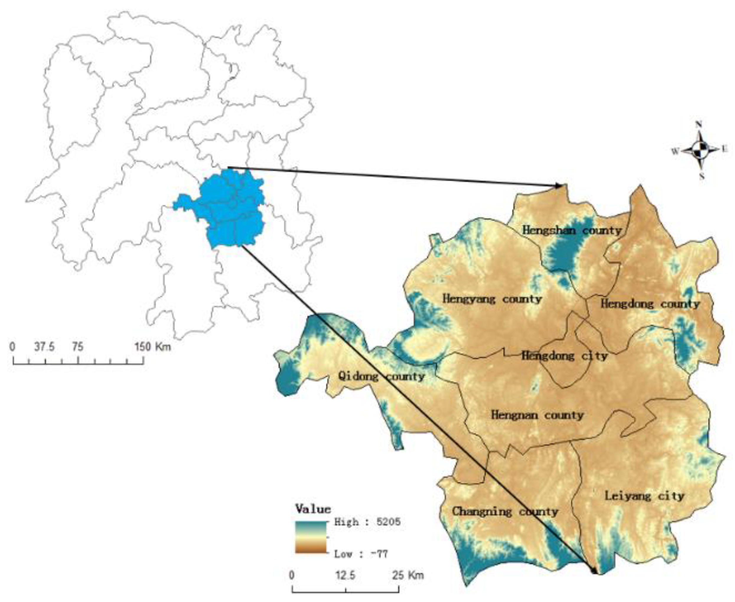
2.1. Study Area
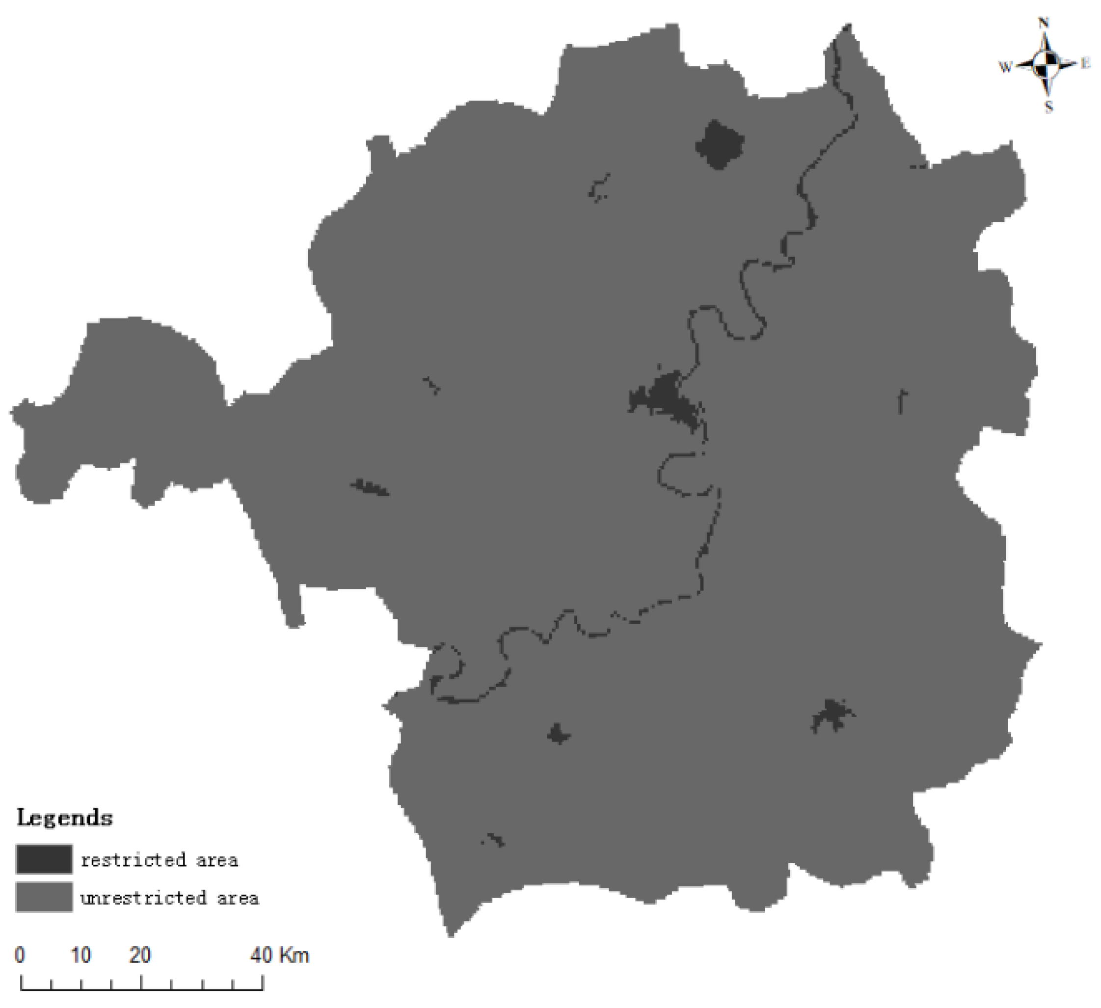
2.2. Data Source and Processing
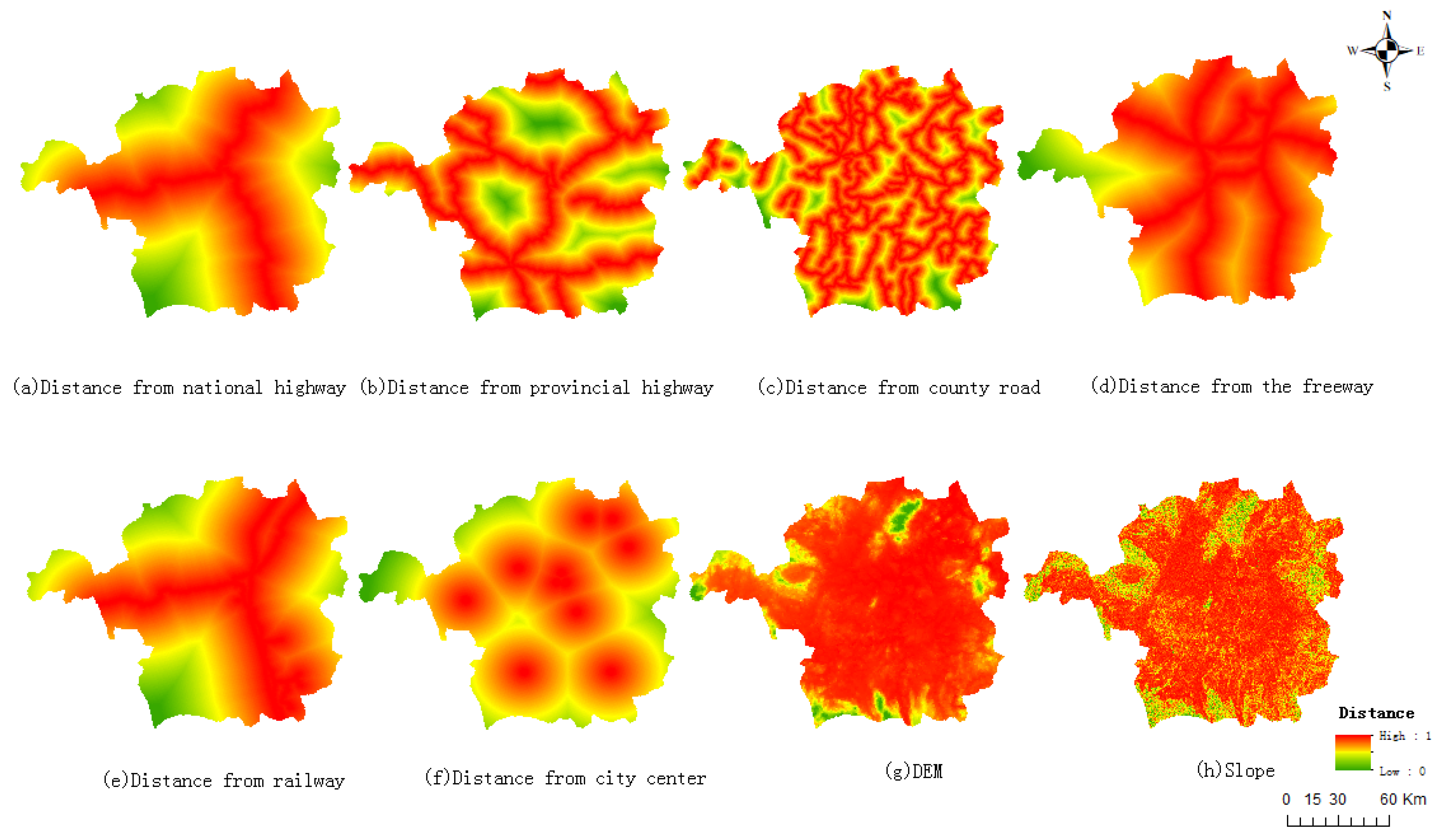
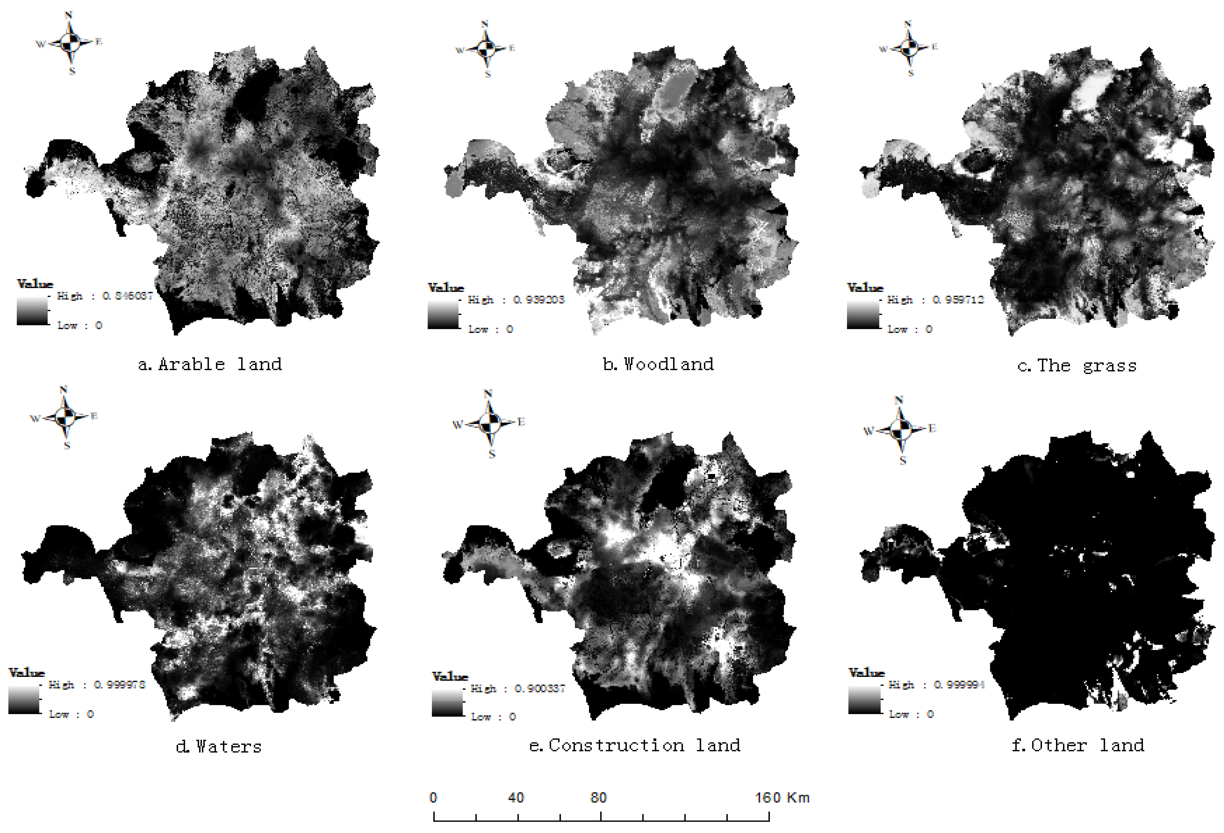
2.3. Analysis of Driving Factors
2.4. FLUS Model
- (1)
- Suitability Probability
- (2)
- Self-adaptive inertia coefficient
- (3)
- Combined probability and neighborhood effects
2.5. Accuracy Verification
3. Results
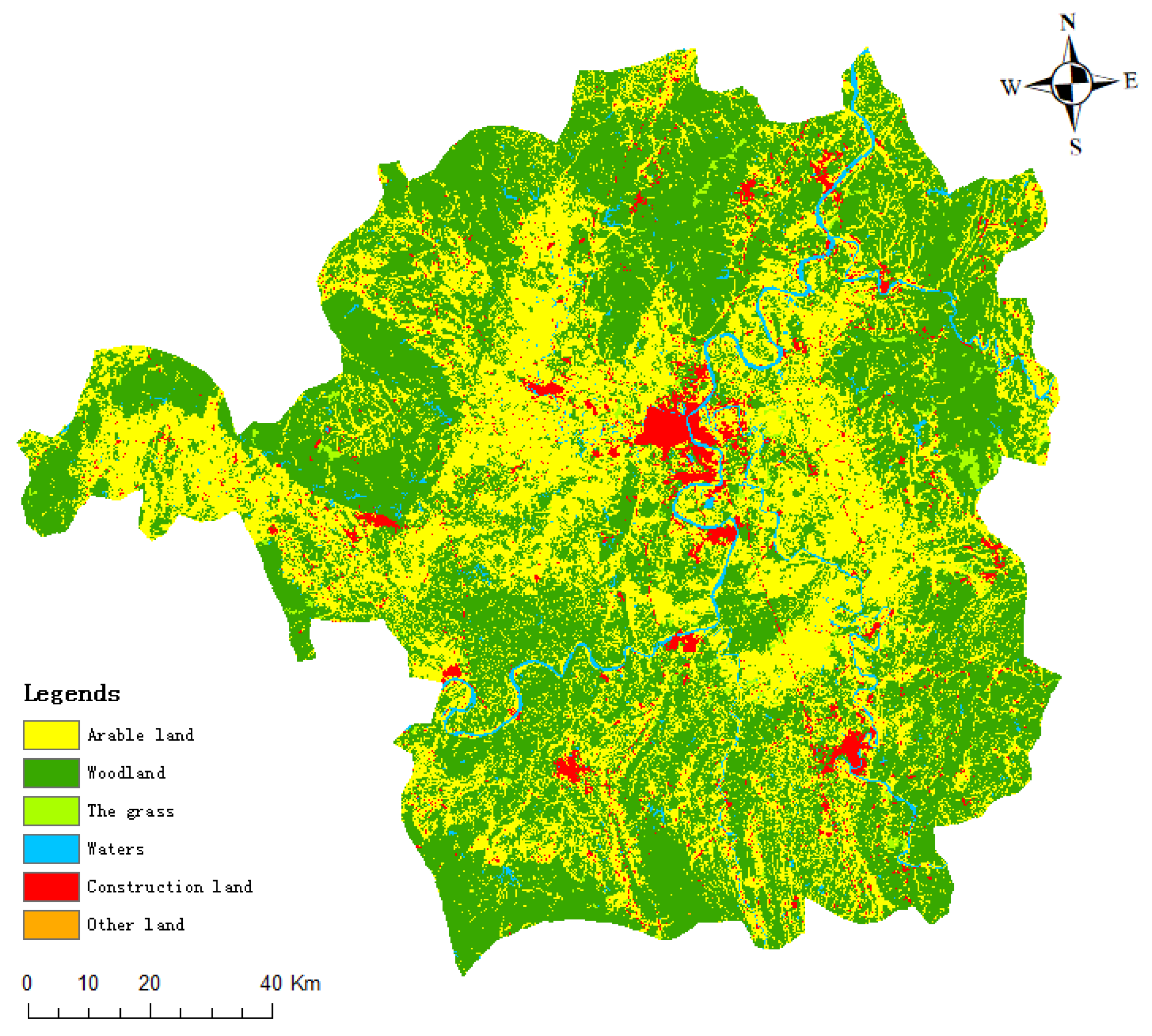
3.1. Land Use Change Matrix
3.2. Simulation Results
3.3. Forecast Results
4. Discussion
5. Conclusions
- (1)
- According to the analysis of the land use transfer matrix, in the past 8 years there has been a general trend in conversion of various land-use types to ecological land (woodland/grassland/water). Compared with the period from 2010 to 2015, the conversion rate of various land-use types to ecological land in Hengyang City from 2015 to 2018 is higher.
- (2)
- Driving factors and limiting factors with good explanatory power were selected, and the suitability probability of each land use type calculated by using a uniform sampling method and ANN model, and the spatial distribution pattern of land use under ecological constraints analyzed, consistent with the social and natural conditions of Hengyang. The results are convincing.
- (3)
- The accuracy of the FLUS model is verified by two indicators of the OA index, Kappa coefficient: the overall accuracy in 2015 and 2018 is higher than 0.95, and the Kappa coefficient is higher than 0.7, which proved that the simulation accuracy of the model is high.
- (4)
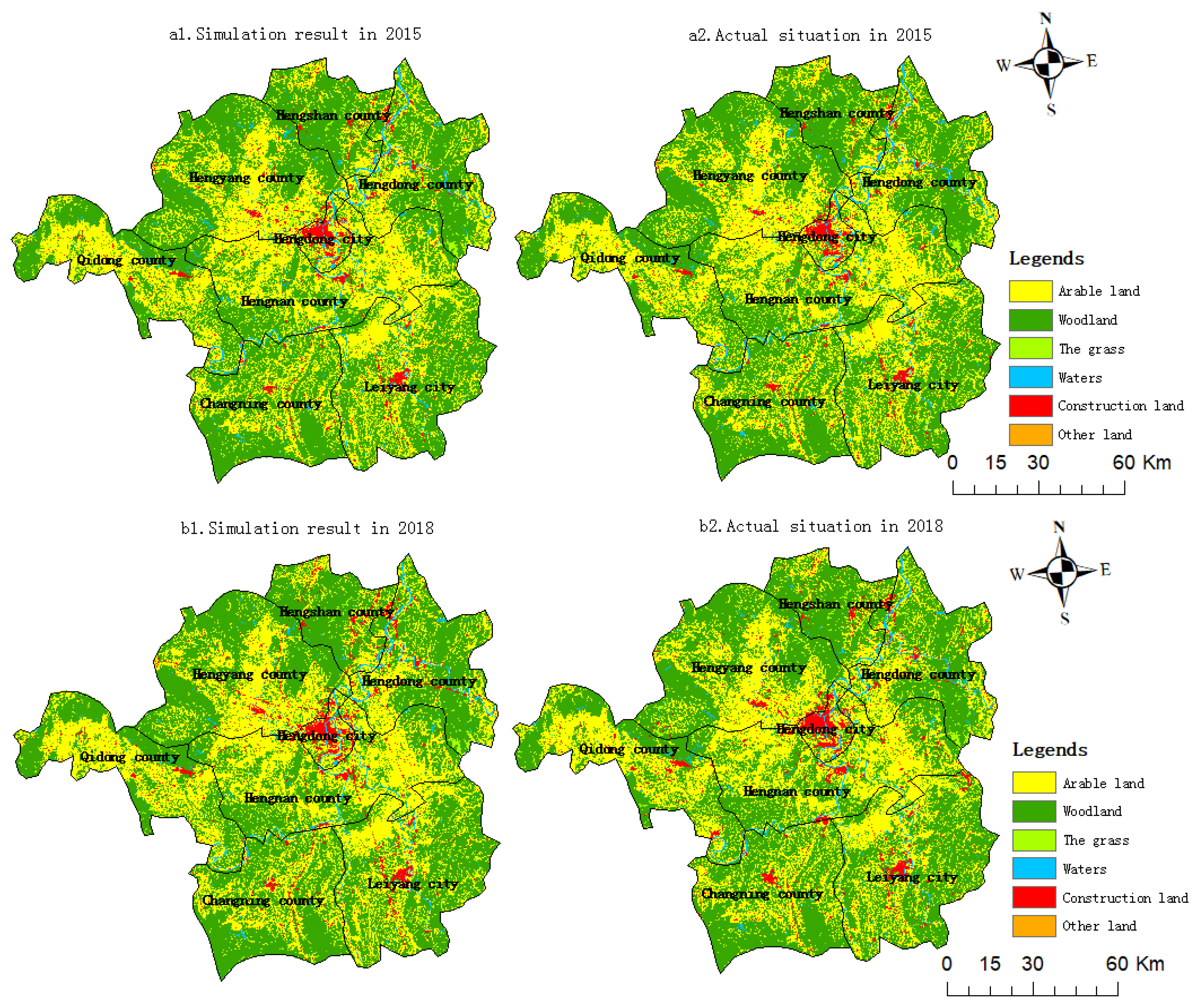
- The change of ecological land in Hengyang is mainly distributed in the surrounding and marginal areas. The main reason for this phenomenon is the topography of Hengyang City. According to the comparison diagram of the land-use status and simulation results in Hengyang City in 2015 and 2018 (Figure 5), it can be seen that the changes of various land types in 2015 are subtle and difficult to observe. However, in 2018, the transformation of non-ecological land to ecological land is obvious in Hengyang City, and the distribution area of ecological land has expanded significantly.
- (5)
- The Markov chain can be used to predict the quantity of land use of different types in Hengyang in 2025, and to simulate the spatial layout of land use in the perspective of environment protection priority. The results show that there is more ecological land in the surrounding areas of Hengyang city, with forest land as the mainland type, and more construction land at the bottom of the basin.
Author Contributions
Funding
Institutional Review Board Statement
Informed Consent Statement
Data Availability Statement
Acknowledgments
Conflicts of Interest
References
- Cao, L.D.; Li, J.L.; Ye, M.Y.; Pu, R.L.; Liu, Y.C.; Guo, Q.D.; Feng, B.X.; Song, X.Y. Changes of ecosystem service value in a coastal zone of Zhejiang province, China, during rapid urbanization. Int. J. Environ. Res. Public Health 2018, 15, 1301. [Google Scholar] [CrossRef] [PubMed] [Green Version]
- Costanza, R.; de Groot, R.; Sutton, P.; der Ploeg, S.; Anderson, S.J.; Kubiszewski, I.; Farber, S.; Turner, R.K. Changes in the global value of ecosystem services. Glob. Environ. Chang. 2014, 26, 152–158. [Google Scholar] [CrossRef]
- Grimm, N.B.; Faeth, S.H.; Golubiewski, N.E.; Redman, C.L.; Wu, J.G.; Bai, X.M.; Briggs, J.M. Global change and the ecology of cities. Science 2008, 319, 756–760. [Google Scholar] [CrossRef] [Green Version]
- Folke, C.; Jansson, A.; Larsson, J.; Costanza, R. Ecosystem by cities appropriation. Ambio 1997, 26, 167–172. [Google Scholar]
- Hu, S.; Chen, L.Q.; Li, L.; Wang, B.Y.; Yuan, L.N.; Cheng, L.; Yu, Z.Q.; Zhang, T. Spatiotemporal dynamics of ecosystem service value determined by land-use changes in the urbanization of Anhui province, China. Int. J. Environ. Res. Public Health 2019, 16, 5104. [Google Scholar] [CrossRef] [PubMed] [Green Version]
- Yuan, J.; Bian, Z.; Yan, Q.; Pan, Y. Spatio-temporal distributions of the land use efficiency coupling coordination degree in mining cities of western China. Sustainability 2019, 11, 5288. [Google Scholar] [CrossRef] [Green Version]
- Ji, X.M.; Wang, K.; Ji, T.; Zhang, Y.H.; Wang, K. Coupling analysis of urban land use benefits: A case study of Xiamen city. Land 2020, 9, 155. [Google Scholar] [CrossRef]
- Yu, J.; Zhou, K.; Yang, S. Land use efficiency and influencing factors of urban agglomerations in China. Land Use Policy 2019, 88, 104143. [Google Scholar] [CrossRef]
- Gao, P.; Niu, X.; Wang, B. Land use changes and its driving forces in hilly ecological restoration area based on gis and rs of northern china. Sci. Rep. 2015, 5, 11038. [Google Scholar] [CrossRef] [Green Version]
- Su, S.L.; Xiao, R.; Jiang, Z.L.; Zhang, Y. Characterizing landscape pattern and ecosystem service value changes for urbanization impacts at an eco-regional scale. Appl. Geogr. 2012, 34, 295–305. [Google Scholar] [CrossRef]
- Yang, L.; Xie, Y.W.; Zong, L.L.; Qiu, T.; Jiao, J.Z. Land use optimization configuration based on multi- objective genetic algorithm and FLUS model of agro-pastoral ecotone in Northwest China. J. Geo-Inf. Sci. 2020, 22, 568–579. [Google Scholar]
- Deng, J.L. Grey dynamic model (GM) and its application in long-term grain forecasting. Nat. Explor. 1984, 3, 37–43. [Google Scholar]
- Deng, J.L. Grey System Forecast and Decision; Huazhong University of Science and Technology Press: Wuhan, China, 1986; pp. 45–109. [Google Scholar]
- Wang, Q.F. System Dynamics, 2nd ed.; Tsinghua University Press: Beijing, China, 1994; pp. 26–90. [Google Scholar]
- Forrester, J.W. Industrial dynamics: A major breakthrough for decision makers. Harv. Bus. Rev. 1958, 36, 37–66. [Google Scholar]
- Atkinson, R.C. A markov model for discrimination learning. Psychometrika 1958, 23, 4. [Google Scholar] [CrossRef]
- Chuvieco, E. Integration of linear programming and GIS for land-use modelling. Int. J. Geogr. Inf. Sci. 1993, 7, 1. [Google Scholar] [CrossRef]
- Zhang, H.H.; Zeng, Y.N.; Jin, X.B.; Shu, B.Y.; Zhou, Y.K.; Yang, X.H. Simulating multiobjective land use optimization allocation using Multiagent system: A case study in Changsha, China. Ecol. Model. 2016, 320, 334–347. [Google Scholar] [CrossRef]
- Li, X.; Ye, J.A. Cellular automata based on neural network and simulation of complex land use system. Geogr. Res. 2005, 1, 19–27. [Google Scholar]
- Zhang, Y.X.; Wei, H.; Na, J.M.; Ou, W.X.; Lan, J.; Lu, X. Construction of urban ecological security pattern based on MCR model: A case study of Pingliang, Gansu Province. J. Nanjing Norm. Univ. Nat. Sci. Ed. 2021, 624, 1–13. [Google Scholar]
- Yang, K.; Cao, Y.G.; Feng, Z.; Geng, B.J.; Feng, Y.; Wang, S.F. Research progress of ecological security pattern construction based on minimum cumulative resistance model. J. Ecol. Rural. Environ. 2021, 3705, 555–565. [Google Scholar]
- Yu, C.L.; Liu, D.; Feng, R.; Tang, Q.; Guo, C.L. Construction of ecological security pattern in Northeast China based on MCR model. Acta Ecol. Sin. 2021, 4101, 290–301. [Google Scholar]
- Chen, B.F.; Zhang, Y.M.; Jiang, D. Research on urban land expansion in fuzhou based on ca-abm model. Prog. Geogr. 2017, 3605, 626–634. [Google Scholar]
- Li, X.; Ma, X.D.; Xiao, C.J.; Ou, M.H. The Regional Land Use Layout Optimization Based on CLUE-S Model. Econ. Geogr. 2015, 3501, 162–167. [Google Scholar]
- Liu, X.; Zhao, Y.X.; Feng, X.M.; Wu, A.B.; Li, R.H. Simulation and Optimization of Multi-objective Land Use on CLUE-S model: A case study of the Three Northern Counties of Langfang in Hebei Province. Geogr. Geo-Inf. Sci. 2018, 3405, 92–98. [Google Scholar]
- Lin, P.F.; Zheng, R.B.; Hong, X.; Zheng, X.; Zheng, W.L. Simulation of land use spatial layout based on FLUS model A case study of Huadu District, Guangzhou. Land Nat. Resour. Res. 2019, 2, 7–13. [Google Scholar]
- Zhang, Z.M.; Liu, P.H.; Zhu, S.H. Delimitation of Urban Land Growth Boundary Based on FLUS Model: A Case Study of Linchuan District. Acta Agric. Jiangxi 2018, 3005, 117–123. [Google Scholar]
- Liu, X.P.; Liang, X.; Li, X.; Xu, X.C.; Ou, J.P.; Chen, Y.M.; Li, S.Y.; Wang, S.J.; Pei, F.S. A future land use simulation model (FLUS) for simulating multiple land use scenarios by coupling human and natural effects. Landsc. Urban Plan. 2017, 168, 96–116. [Google Scholar] [CrossRef]
- Zhao, L.F.; Liu, X.P.; Liu, P.H.; Chen, G.Z.; He, J.L. Urban Expansion Simulation and Early Warning based on Geospatial Partition and FLUS Model. J. Geo-Inf. Sci. 2020, 2203, 517–530. [Google Scholar]
- Huang, K.; Dai, W.Y.; Huang, W.L.; Ou, H. Study on the Delimitation of Urban Growth Boundary based on FLUS Model and kinetic energy theorem. J. Geo-Inf. Sci. 2020, 2203, 557–567. [Google Scholar]
- Wang, B.S.; Liao, J.F.; Zhu, W.; Qiu, Q.Y.; Wang, L.; Tang, L.N. The weight of neighborhood setting of the FLUS model based on a historical scenario: A case study of land use simulation of urban agglomeration of the Golden Trangle of Southern Fujian in 2030. Acta Ecol. Sin. 2019, 3912, 4284–4298. [Google Scholar]
- Zhang, J.D.; Mei, Z.X.; Lu, J.H.; Chen, J.Z. Simulating Multiple Land Use Scenarios based on the FLUS Model Considering Spatial Autocorrelation. J. Geo-Inf. Sci. 2020, 2203, 531–542. [Google Scholar] [CrossRef]
- Lin, W.B.; Sun, Y.M.; Nijhuis, S.; Wang, Z.L. Scenario-based flood risk assessment for urbanizing deltas using future land-use simulation (FLUS): Guangzhou Metropolitan Area as a case study. Sci. Total Environ. 2020, 739, 139899. [Google Scholar] [CrossRef] [PubMed]
- Zhu, S.H.; Shu, B.R.; Ma, X.D.; Liang, X.; Yao, Q. The Delineation of Urban Growth Boundary Based on the Idea of “Anti-planning” and FLUS Model: A Case Study of Jiawang District, Xuzhou City. Geogr. Geo-Inf. Sci. 2017, 3305, 80–86. [Google Scholar]
- Zhang, S.Y.; Liu, X.P.; Yan, S.Z.; Zhan, Q.; Liu, T.Q. Delineation of Urban Development Boundaries Using Two Basic Evaluations and FLUS-UGB: A Case Study of Changchun. Trop. Geogr. 2019, 3903, 377–386. [Google Scholar]
- Su, Y.Q.; Liu, G.; Zhao, J.B.; Niu, J.J.; Zhang, E.Y.; Guo, L.G.; Lin, F. Multi-scenario simulation prediction of ecological space in the Fenhe River Basin using the FLUS model. Arid Zone Res. 2021, 3804, 1152–1161. [Google Scholar]
- He, D.; Jin, F.J.; Zhou, J. The Changes of Land Use and Landscape Pattern Based on Logistic-CA-Markov Model—A Case study of Beijing-Tianjin-Hebei Metropolitan Region. Sci. Geogr. Sin. 2011, 3108, 903–910. [Google Scholar]
- Yue, D.X.; Yang, C.; Jiang, B.H.; Guo, J.J.; Xu, X.F. Spatial-temporal Prediction of the biocapacity in the Shiyang River on the basis of the CA-Markov model. Acta Ecol. Sin. 2019, 3906, 1993–2003. [Google Scholar]
- Sun, D.Z.; Liang, Y.J. Multi-scenario simulation of land use in the Loess Plateau based on improved Markov-CA model. J. Geo-Inf. Sci. 2021, 2305, 825–836. [Google Scholar]
- Lauf, S.; Haase, D.; Hostert, P.; Lakes, T.; Kleinschmit, B. Uncovering land-use dynamics driven by human decision-making-combined model approach using cellular automata and system dynamics. Environ. Model. Softw. 2012, 27–28, 71–82. [Google Scholar] [CrossRef]
- Xu, X.M.; Du, Z.Q.; Zhang, H. Integrating the system dynamic and cellular automata models to predict land useand land cover change. Int. J. Appl. Earth Obs. Geoinf. 2016, 52, 568–579. [Google Scholar] [CrossRef]
- Wang, L.P.; Jin, X.B.; Du, X.D.; Zhou, Y.K. Land use scenario simulation of Foshan City based on grey model and cellular automata model. Trans. Chin. Soc. Agric. Eng. 2012, 2803, 237–242. [Google Scholar]
- Wang, H.; Liu, Y. Optimal Allocation of Land Resources Based on MOP-CA. Geomat. Inf. Sci. Wuhan Univ. 2009, 3402, 174–177. [Google Scholar]
- Wu, M.; Ren, X.Y.; Che, Y.; Yang, K. A coupled SD and CLUE-S model for exploring the impact of land use change on eco-system service value: A case study in Baoshan district, Shanghai, China. Environ. Manag. 2015, 5602, 402–419. [Google Scholar] [CrossRef] [PubMed]
- Wei, W. Land use optimal allocation based on CLUE-S and MCR model in Shiyang River Basin. Ph.D. Thesis, Lanzhou University, Lanzhou, China, 6 June 2018. [Google Scholar]
- Zhu, C.J.; Tian, B.; Zhou, Y.X.; Fan, Z.Q. Wetland Change Analysis and Forecasting in Pudong New Area Using Markov and CLUE-S Model. J. Fudan Univ. Nat. Sci. 2015, 5404, 431–438. [Google Scholar]
- Lin, Y.L.; Zhao, J.S.; Chen, G.P.; Zhang, M. Optimization of regional Territory Space pattern Based on MCR-FLUS-Markov Model. Trans. Chin. Soc. Agric. Mach. 2021, 5204, 159–170. [Google Scholar]
- Zhang, X.R.; Li, A.N.; Wang, C.B.; Lei, G.B. Multi-scenario Simulation of Land Use Change Along China-Pakistan Economic Corridor through Coupling FLUS Model with SD Model. J. Geo-Inf. Sci. 2020, 2212, 2393–2409. [Google Scholar]
- Pan, J.H.; Shi, P.J.; Zhao, R.F. Research on Optimal Allocation Model of Land Use Structure Based on LP-MCDM-CA model: The Case of Tianshui. J. Mt. Sci. 2010, 2804, 407–414. [Google Scholar]
- Zhang, M.M.; Zhang, R.Q.; Hao, J.M.; Ai, D. The Scenarios Simulation Analysis of Driving Forces of Wetland Landscape Evolution Using ANN-CA in Yinchuan Plain. J. Geo-Inf. Sci. 2014, 1603, 418–425. [Google Scholar]
- Yan, Y.H.; Guo, Z.J.; Wang, W.Y.; Xu, Y.Z. Research on Landscape Pattern Changes and Prediction in port City Based on ANN-CA Model: A Case Study of the West Coast of Jiaozhou Bay. Resour. Environ. Yangtze Basin 2020, 2907, 1507–1514. [Google Scholar]
- Lu, J.H.; Mei, Z.X.; Zhao, S.F.; Xiao, Y.Y. Land Use Optimization Allocation Based on Chaos Ant Colony Algorithm. J. Geo-Inf. Sci. 2017, 1908, 1026–1035. [Google Scholar]
- Liu, X.P.; Li, X.; Shi, X.; Huang, K.N.; Liu, Y.L. A multi-type ant colony optimization (MACO) method for optimal land use allocation in large areas. Int. J. Geogr. Inf. Sci. 2012, 2607, 1325–1343. [Google Scholar] [CrossRef]
- Stewart, T.J.; Janssen, R.; Van Herwijnen, M. A genetic algorithm approach to multiobjective land use planning. Comput. Oper. Res. 2004, 3114, 2293–2313. [Google Scholar] [CrossRef]
- Liu, Y.; Yuan, M.; He, J.H.; Yuan, F.L. Regional land-use allocation with a spatially explicit genetic algorithm. Landsc. Ecol. Eng. 2015, 1101, 209–219. [Google Scholar] [CrossRef]
- Cao, K.; Huang, B.; Wang, S.W.; Hui, L. Sustainable land use optimization using Boundary-based Fast Genetic Algorithm. Comput. Environ. Urban. Syst. 2012, 3603, 257–269. [Google Scholar] [CrossRef]
- Liu, Y.L.; Xia, Y.; Liu, D.F.; Hong, X.F. Optimization of Land Use Zoning based on Programming and Simulated Annealing. Geomat. Inf. Sci. Wuhan Univ. 2012, 3707, 762–765. [Google Scholar]
- Wang, D.W.; Li, F.X.; Chen, D. Eesearch on Optimal Land Use Allocation Based on Pareto optimal and Multi-particle Swarm Algorithm. Resour. Environ. Yangtze Basin 2019, 2809, 2019–2029. [Google Scholar]
- Ul Din, S.; Mak, H.W.L. Retrieval of Land-Use/Land Cover Change (LUCC) Maps and Urban Expansion Dynamics of Hyderabad, Pakistan via Landsat Datasets and Support Vector Machine Framework. Remote Sens. 2021, 13, 3337. [Google Scholar] [CrossRef]
- Zhang, D.C.; Liu, X.P.; Yao, Y.; Zhang, J. Simulation Spatiotemporal Change of Multiple Land Use Types in Dongguan City by using Random Forest Based on Cellular Automata. Geogr. Geo-Inf. Sci. 2016, 3205, 29–36. [Google Scholar]
- Ma, B.Y.; Huang, J.; Li, S.C. Optimal allocation of land use types in the Beijing-Tianjin-Hebei urban agglomeration based on ecological and economic benefits trade-offs. Prog. Geogr. 2019, 3801, 26–37, (In Chinese with English abstract). [Google Scholar]
- Zhao, X.; Peng, J.D.; Fan, Z.Y.; Yang, C.; Yang, H. Land Use Simulation and Urban Growth Boundaries Delineation in Wuhan Metropolitan Area based on FLUS model and “Dual Environment Evaluation”. J. Geo-Inf. Sci. 2020, 2211, 2212–2226. [Google Scholar]
- Wang, X.; Ma, B.; Li, D.; Chen, K.; Yao, H.S. Multi-scenario simulation and prediction of ecological space in Hubei Province based on FLUS model. J. Nat. Resour. 2020, 3501, 230–242. [Google Scholar]
- Luo, S. Study on Optimization for the Land Use Structure in the Process of Urbanization in Hengyang City. Master’s Thesis, Hunan Agricultural University, Changsha, China, 7 June 2011. [Google Scholar]
- Yu, M. Study on Cropland Spatio-temporal Dynamics Change Detection in Hengyang Basin on Remote Sensing Time Series Analysis. Master’s Thesis, China University of Geosciences, Beijing, China, 2 June 2020. [Google Scholar]
- Wang, K.; Cai, Z.H.; Qi, Z.X.; Chen, J.; Li, H.; Li, T.; Feng, Q. The impact of land use pattern change on ecosystem services in Hengyang City in 2000 and 2013. Chin. J. Eco-Agric. 2017, 2507, 1060–1070. [Google Scholar]
- Shi, L.; He, Q.H.; Xiao, X. Study on the Eco-environmental Effect of Land Use Change in the Main Urban Area of Hengyang City. Anhui Agric. Sci. Bull. 2019, 25Z1, 119–124. (In Chinese) [Google Scholar]
- Bai, J.J.; Wang, Z.Y.; Qi, Z.X. Research on Grey Correlation Degree between Construction Land Structure and Economic Development in Hengyang City. Chin. Foreign Archit. 2020, 10, 113–116. [Google Scholar]
- Wang, P.; Kuang, F.M.; Deng, Y.W.; Tian, Y.P.; Ouyang, S.L. Assessment of Land Ecological Security in Red Soil Hilly Region of South Hunan: A Case Study of Hengyang City. Res. Soil Water Conserv. 2013, 2003, 243–248. [Google Scholar]
- Wang, P.; Xu, W.D.; Deng, Y.W.; Tian, Y.P. On Dynamic Evaluation of Land Ecological safety in the Process of Urbanization: A case study of Hengyang City. J. Hengyang Norm. Univ. 2016, 3703, 81–86. [Google Scholar]
- Zhang, C.C.; Wang, P.; Xiong, P.S.; Zhang, Y. Evaluation and Dynamic Analysis of Land Ecological Security Based on PSR Model—Taking Hengyang City as An Example. J. Hengyang Norm. Univ. 2020, 4103, 111–116. [Google Scholar]
- Huang, F.Q.; Wang, Z.Y.; Liu, H.; Qi, Z.X.; Wu, X.X. Delimitation of Urban Growth Boundaries Based on Ecosystem Service Value: A Case Study of Hengy- ang Central Area. J. Ecol. Rural. Environ. 2020, 3609, 1115–1125. [Google Scholar]
- Yiftachel, O.; Hedgcock, D. Urban social sustainability: The planning of an Australian city. Cities 1993, 10, 139–157. [Google Scholar] [CrossRef]
- Brelsford, C.; Lobo, J.; Hand, J.; Bettencourt, L.M. Heterogeneity and scale of sustainable development in cities. Proc. Natl. Acad. Sci. USA 2017, 114, 8963–8968. [Google Scholar] [CrossRef] [Green Version]
- Peng, L.; Chen, T.; Wang, Q.; Deng, W. Linking Ecosystem Services to Land Use Decisions: Policy Analyses, Multi-Scenarios, and Integrated Modelling. ISPRS Int. J. Geo-Inf. 2020, 9, 154. [Google Scholar] [CrossRef] [Green Version]
- Chang, B.; Chen, L. Land Economic Efficiency and Improvement of Environmental Pollution in the Process of Sustainable Urbanization: Case of Eastern China. Land 2021, 10, 845. [Google Scholar] [CrossRef]
- Ding, X.; Zheng, M.; Zheng, X. The Application of Genetic Algorithm in Land Use Optimization Research: A Review. Land 2021, 10, 526. [Google Scholar] [CrossRef]


| Attribute | Types | Data Sources |
|---|---|---|
| Raster data | Land use data | Resources and Environment Science and Data Center (www.resdc.cn (accessed on 26 March 2021)) |
| Vector data | The road data | National Catalogue Service For Geographic Information (www.webmap.cn (accessed on 26 March 2021)) |
| City point data | National Catalogue Service For Geographic Information (www.webmap.cn (accessed on 29 March 2021)) | |
| Administrative district data | National Platform for Common Geospatial Information Services (www.tianditu.cn (accessed on 29 March 2021)) | |
| Data on rivers and lakes | National Catalogue Service For Geographic Information (http://www.webmap.cn/ (accessed on 9 April 2021)) | |
| natural reserve data | Data on Hengyang National Nature Reserve |
| Types | Name | Types | Name |
|---|---|---|---|
| Arable Land | Paddy Field | Glacial Permanent Snow | |
| The Try Land | Tidal Marsh | ||
| Woodland | Forest Land | Beaches | |
| Shrub Land | Construction Land | Cities and Towns | |
| Open Forest Land | Rural Settlements | ||
| Other Woodlands | Construction Land for Industry and Transportation | ||
| The Grass | Grassland with High Coverage | Other Lands | The Sand |
| Moderate Grass Coverage | The Gobi | ||
| Low Coverage Grass | Saline-alkali Land | ||
| Waters | Graff | Marsh Land | |
| Lakes | Bare Land | ||
| Reservoir and Ponds | Bare Rock and Gravel Fields |
| Year | OA | Kappa |
|---|---|---|
| 2015 | 0.964 | 0.76 |
| 2018 | 0.95 | 0.72 |
| Types (ha) | 2010 | 2015 | 2018 | |||
|---|---|---|---|---|---|---|
| Area | Percentage | Area | Percentage | Area | Percentage | |
| Arable Land | 590,321.4 | 38.29% | 589,971.9 | 38.28% | 580,106.7 | 37.64% |
| Woodland | 865,887.6 | 56.17% | 861,770.7 | 55.91% | 856,449.6 | 55.56% |
| The Grass | 14,564.8 | 0.94% | 14,293.0 | 0.93% | 13,982.2 | 0.91% |
| Waters | 30,566.7 | 1.98% | 30,760.9 | 2.00% | 31,304.6 | 2.03% |
| Construction Land | 39,927.0 | 2.59% | 44,315.9 | 2.88% | 59,307.9 | 3.85% |
| Other Lands | 271.9 | 0.02% | 271.9 | 0.02% | 233.0 | 0.02% |
| To 2015 | Total | ||||||
|---|---|---|---|---|---|---|---|
| Arable Land | Woodland | The Grass | Waters | Construction Land | Other Lands | ||
| From 2010 | |||||||
| Arable Land | 581,427.2 | 6408.5 | 38.8 | 233.0 | 2213.9 | 0.0 | 590,380.5 |
| Woodland | 7573.7 | 854,663.0 | 116.5 | 388.4 | 3146.0 | 0.0 | 865,974.2 |
| The Grass | 271.9 | 155.4 | 14,137.6 | 0.0 | 0.0 | 0.0 | 14,566.3 |
| Waters | 233.0 | 155.4 | 0.0 | 30,139.4 | 38.8 | 0.0 | 30,569.7 |
| Construction Land | 621.4 | 388.4 | 0.0 | 0.0 | 38,917.2 | 0.0 | 39,931.0 |
| Other Lands | 0.0 | 0.0 | 0.0 | 0.0 | 0.0 | 271.9 | 271.9 |
| Total | 590,127.2 | 861,770.7 | 14,292.9 | 30,760.9 | 44,315.9 | 271.9 | 1,541,539.4 |
| To 2018 | Total | ||||||
|---|---|---|---|---|---|---|---|
| Arable Land | Woodland | The Grass | Waters | Construction Land | Other Lands | ||
| From 2015 | |||||||
| Arable Land | 553,773.5 | 24,313.5 | 388.4 | 1514.7 | 9981.7 | 0.0 | 590,030.9 |
| Woodland | 22,138.5 | 82,8601.7 | 349.6 | 1281.7 | 9399.2 | 0.0 | 861,856.8 |
| The Grass | 466.1 | 427.2 | 13,244.3 | 0.0 | 155.4 | 0.0 | 14,294.4 |
| Waters | 1126.3 | 893.3 | 0.0 | 28,352.8 | 388.4 | 0.0 | 30764.0 |
| Construction Land | 2563.4 | 2213.9 | 0.0 | 155.4 | 39,383.2 | 0.0 | 44,320.3 |
| Other Lands | 38.8 | 0.0 | 0.0 | 0.0 | 0.0 | 233.0 | 271.8 |
| Total | 580,106.7 | 856,449.6 | 13,982.2 | 31,304.6 | 59,307.9 | 233.0 | 1,541,384.1 |
| Conversion Types (ha) | 2010–2015 | 2015–2018 | ||
|---|---|---|---|---|
| Area | Percentage | Area | Percentage | |
| No conversion of ecological land | 898,940 | 58.31% | 865,198.8 | 56.13% |
| Ecological land conversion | 815.7 | 0.05% | 2951.8 | 0.19% |
| Conversion of arable land to ecological land | 6680.3 | 0.43% | 26,216.6 | 1.7% |
| Conversion of construction land to ecological land | 388.4 | 0.03% | 2369.3 | 0.15% |
| Conversion of other lands to ecological land | 0 | 0% | 0 | 0% |
| Other conversion conditions | 599,352.4 | 38.88% | 670,952.2 | 41.49% |
| Year | Cultivated Land | Woodland | The Grass | Waters | Construction Land | Other Lands |
|---|---|---|---|---|---|---|
| Actual quantity in 2015 | 6,554,620 | 9,554,202 | 164,375 | 493,918 | 348,305 | 2973 |
| Forecast quantity in 2015 | 6,554,620 | 9,554,202 | 164,375 | 493,918 | 348,305 | 2973 |
| Actual quantity in 2018 | 6,457,814 | 9,499,920 | 161,201 | 653,065 | 348,314 | 2276 |
| Forecast quantity in 2018 | 6,454,997 | 9,497,766 | 161,152 | 652,991 | 349,211 | 2276 |
| Error between predicted and actual quantities in 2018 (%) | −0.04% | −0.02% | −0.03% | −0.01% | 0.26% | 0% |
| Year | Arable Land | Woodland | The Grass | Waters | Construction Land | Other Lands |
|---|---|---|---|---|---|---|
| 2018 | 6,454,985 | 9,497,788 | 161,147 | 349,214 | 652,983 | 2276 |
| 2025 | 6,454,997 | 9,497,766 | 161,152 | 349,211 | 652,991 | 2267 |
Publisher’s Note: MDPI stays neutral with regard to jurisdictional claims in published maps and institutional affiliations. |
© 2021 by the authors. Licensee MDPI, Basel, Switzerland. This article is an open access article distributed under the terms and conditions of the Creative Commons Attribution (CC BY) license (https://creativecommons.org/licenses/by/4.0/).
Share and Cite
Zhang, C.; Wang, P.; Xiong, P.; Li, C.; Quan, B. Spatial Pattern Simulation of Land Use Based on FLUS Model under Ecological Protection: A Case Study of Hengyang City. Sustainability 2021, 13, 10458. https://doi.org/10.3390/su131810458
Zhang C, Wang P, Xiong P, Li C, Quan B. Spatial Pattern Simulation of Land Use Based on FLUS Model under Ecological Protection: A Case Study of Hengyang City. Sustainability. 2021; 13(18):10458. https://doi.org/10.3390/su131810458
Chicago/Turabian StyleZhang, Chuchu, Peng Wang, Pingsheng Xiong, Chunhong Li, and Bin Quan. 2021. "Spatial Pattern Simulation of Land Use Based on FLUS Model under Ecological Protection: A Case Study of Hengyang City" Sustainability 13, no. 18: 10458. https://doi.org/10.3390/su131810458
APA StyleZhang, C., Wang, P., Xiong, P., Li, C., & Quan, B. (2021). Spatial Pattern Simulation of Land Use Based on FLUS Model under Ecological Protection: A Case Study of Hengyang City. Sustainability, 13(18), 10458. https://doi.org/10.3390/su131810458