New Approach to Assess Multi-Scale Coastal Landscape Vulnerability to Erosion in Tropical Storms in Vietnam

 , ,
, ,
Abstract
:1. Introduction
- Is it feasible to use coastal landscape classification systems for CVI assessments at national and regional scales?
- How is the selection of CVI assessment criteria at national and regional scales different?
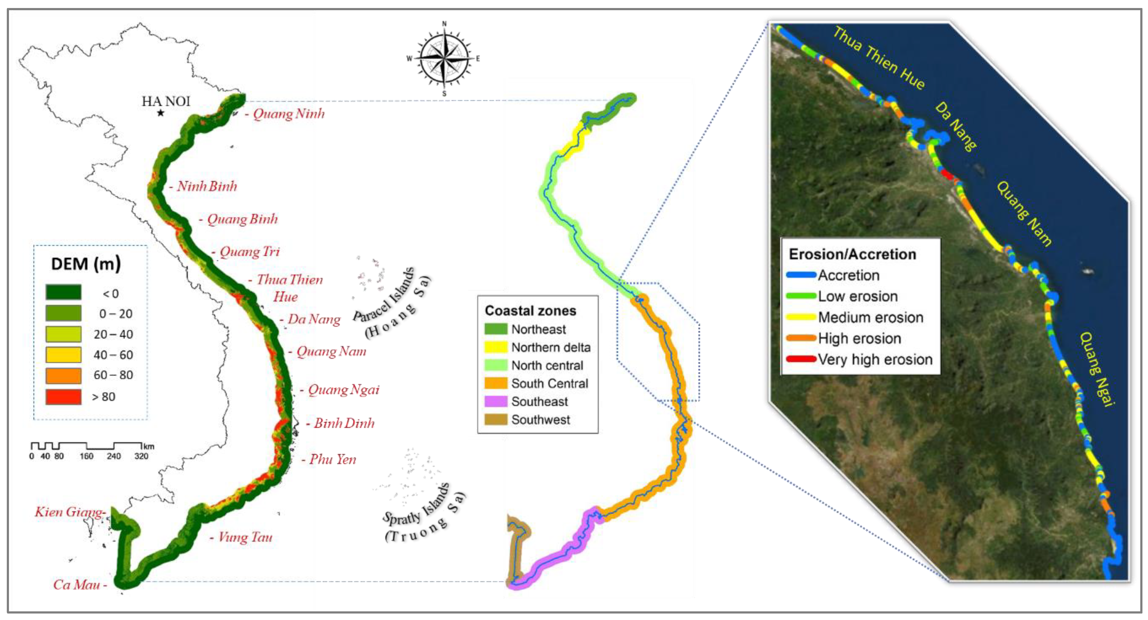
- How vulnerable are the coasts in Vietnam and Central Vietnam to erosion in storms?
2. Materials and Methods
2.1. Case Study
2.2. Multi-Scale Coastal Landscape Classification
2.2.1. Coastal Landscape Classification at National Scale
2.2.2. Coastal Landscape Classification at a Regional Scale
2.3. Coastal Vulnerability Assessment Criterion
2.3.1. Assessment Index System
- The natural aspect includes coastal characteristics and forcing. Coastal characteristics’ indicators include coastal geology-geomorphology, coastal elevation, coastal slope, shoreline change rate, and coastal natural habitat [32]. The index of coastal characteristics is related to the resilience and erosion vulnerability of the coast. The coastal forcing index includes the rate of sea-level change, mean tidal amplitude, wave heights, and storms. In other words, the coastal forcing index describes the factors that cause erosion due to tides, waves, and storms.
- The socio-economic aspect was divided into two parts, including coastal infrastructure and natural hazards mitigation based on the potential damage or the resilience of coastal features in the face of erosion [10]. Coastal infrastructure indicators include the value of roads, the value of buildings, and the activities of the population. Disaster reduction index can be included in financial revenue, coastal dykes, and embankments. While the coastal infrastructure index is an indicator for assessing potential risks, the disaster mitigation index evaluates the prevention level to mitigate natural hazards, especially coastal erosion.
2.3.2. Criteria Selection
2.4. Assessment Model Development
3. Results
3.1. Statistical Analysis of Interdependencies
3.2. Multi-Scale CVI Assessments
3.2.1. CVI Due to Erosion in Vietnam
3.2.2. CVI Due to Erosion in the Central Vietnam
3.3. CVI Index in Landscape Types
4. Discussion
4.1. Comparison with Formal CVI Assessments
4.2. Vulnerability Assessment in Central Vietnam
5. Conclusions
Author Contributions
Funding
Institutional Review Board Statement
Informed Consent Statement
Data Availability Statement
Acknowledgments
Conflicts of Interest
Appendix A

| No. | Criterion | Unit | Coastal Vulnerability Level | ||||
|---|---|---|---|---|---|---|---|
| No | Low | Medium | High | Very High | |||
| 1 | 2 | 3 | 4 | 5 | |||
| A | Coastal characteristics | ||||||
| 1 | Geological structure and materials | - | Magma acids (e.g., granite and riolites) | Metamorphic rocks, magma, and sandstone | Fine-fine grained sedimentary rock | Poor cohesive coarse grain sediment | Homogeneous, fine-grained sediment |
| 2 | Highest slope in 1000 m radius | - | >12 | 9–12 | 6–9 | 3–6 | <3 |
| 3 | Average slope in 1000 m radius | % | >12 | 9–12 | 6–9 | 3–6 | <3 |
| 4 | Width of sandy beaches | m | >300 | 150–300 | 75–150 | 25–75 | <25 |
| 5 | Geomorphological characteristics | - | Coastal steep cliffs | Coastal gentle cliffs | Heterogeneous coastal cliffs, stable estuaries | Sandy bars, pebbles/gravel shore, lagoon | Eroded estuaries delta areas |
| 6 | Coastal protection level from annual prevailing-waves | - | Opposite sides of coming wind/wave | Opposite sides of coming wind/wave in unstable cliffs | Partly opposite sides of coming wind/wave | Direct exposure to waves, but energy is slightly refracted from offshore | Direct exposure to the impact of storm waves without defense |
| B | Coastal forcing factors | ||||||
| 7 | Average wave energy | TW/ month | <1.5 | 1.5–4.2 | 4.2–6.5 | 6.5–9 | >9 |
| 8 | Highest tidal range | cm | <90 | 90–130 | 130–170 | 170–200 | >200 |
| 9 | Average change in sea level (1960s–2014) | m | <−4.0 | −4.5–0.5 | −0.5–3 | 3–5.5 | >5.5 |
| 10 | Total water level during storm | m | <40 | 40–60 | 60–80 | 80–100 | >100 |
| 11 | Storm frequency | Event/year | <0.9 | 0.9–1.3 | 1.3–1.7 | 1.7–2.1 | >2.1 |
| 12 | Maximum rainfall (during the day) | mm | <300 | 300–500 | 500–700 | 700–900 | >900 |
| 13 | Rate of shoreline variation (erosion/accretion) | m/ year | >0 (accretion) | −1 to 0 | −3 to −1 | −5 to −3 | <−5 |
| C | Socio-Economic factors | ||||||
| 14 | Population density | Person/km2 | <100 | 100–200 | 200–400 | 400–600 | >600 |
| 15 | Distance from coastline to buildings | m | >600 | 200–600 | 100–200 | 50–100 | <50 |
| 16 | Land cover type behind beaches | - | Protection forest (including mangrove) | Sparse vegetation and agriculture | Rural with vegetation | Urbanized areas with sparse vegetation | Urban, industrials, ports, and tourism areas |
| 17 | Coastal protection constructions (dykes/embankments/sea walls) | - | Very solid sea-walls | Solid construction | Semi-solid construction | Temporary dyke/embankment | No construction |
References
- Liquete, C.; Zulian, G.; Delgado, I.; Stips, A.; Maes, J. Assessment of coastal protection as an ecosystem service in Europe. Ecol. Indic. 2013, 30, 205–217. [Google Scholar] [CrossRef] [Green Version]
- Theodoro, G.; Pereira, N.; Lima, D.; Cristina, V.; Sanches, L.; Ferreira, R. Identifying driving forces of landscape changes: Historical relationships and the availability of ecosystem services in the Atlantic forest. Ecosyst. Serv. 2016, 22, 11–17. [Google Scholar] [CrossRef]
- Van der Biest, K.; De Nocker, L.; Provoost, S.; Boerema, A.; Staes, J.; Meire, P. Dune dynamics safeguard ecosystem services. Ocean Coast. Manag. 2017, 149, 148–158. [Google Scholar] [CrossRef]
- Aparna, P.; Nigee, K.; Shimna, P.; Drissia, T.K. Quantitative Analysis of Geomorphology and Flow Pattern Analysis of Muvattupuzha River Basin Using Geographic Information System. Aquat. Procedia 2015, 4, 609–616. [Google Scholar] [CrossRef]
- Pye, K.; Blott, S.J. The geomorphology of UK estuaries: The role of geological controls, antecedent conditions and human activities. Estuar. Coast. Shelf Sci. 2014, 150, 196–214. [Google Scholar] [CrossRef]
- Boak, E.H.; Turner, I.L. Shoreline Definition and Detection: A Review. J. Coast. Res. 2005, 214, 688–703. [Google Scholar] [CrossRef] [Green Version]
- Cooper, J.A.G.; O’Connor, M.C.; McIvor, S. Coastal defences versus coastal ecosystems: A regional appraisal. Mar. Policy 2016, 111, 102332. [Google Scholar] [CrossRef]
- Alongi, D.M. Present state and future of the world’s mangrove forests. Environ. Conserv. 2002, 29, 331–349. [Google Scholar] [CrossRef] [Green Version]
- Hapke, C.; Plant, N. Predicting coastal cliff erosion using a Bayesian probabilistic model. Mar. Geol. 2010, 278, 140–149. [Google Scholar] [CrossRef] [Green Version]
- Zhu, Z.T.; Cai, F.; Chen, S.L.; Gu, D.Q.; Feng, A.P.; Cao, C.; Qi, H.S.; Lei, G. Coastal vulnerability to erosion using a multi-criteria index: A case study of the Xiamen coast. Sustainability 2018, 11, 93. [Google Scholar] [CrossRef] [Green Version]
- Van Cong, L.; Van Cu, N.; Shibayama, T. Assessment of Vietnam Coastal Erosion and Relevant Laws and Policies; Elsevier: Amsterdam, The Netherlands, 2014; ISBN 9780128004791. [Google Scholar]
- Vu, V.P. Studying and Assessing Coastal Changes in Southern Provinces (Vietnam) under the Impact of Climate Change and Sea Level Rise; Vietnam National University Press: Hanoi, Vietnam, 2013. (In Vietnamese) [Google Scholar]
- Noy, I.; Vu, T.B. The economics of natural disasters in a developing country: The case of Vietnam. J. Asian Econ. 2010, 21, 345–354. [Google Scholar] [CrossRef] [Green Version]
- Takagi, H.; Thao, N.D.; Esteban, M.; Mikami, T.; Van Cong, L.; Ca, V.T. Coastal Disasters in Vietnam; Elsevier: Amsterdam, The Netherlands, 2015; ISBN 9780128012703. [Google Scholar]
- Takagi, H.; Esteban, M.; Thao, N.D. Introduction: Coastal Disasters and Climate Change in Vietnam; Elsevier: Amsterdam, The Netherlands, 2014; ISBN 9780128004791. [Google Scholar]
- Trinh, T.-A.; Feeny, S.; Posso, A. The Impact of Natural Disasters and Climate Change on Agriculture: Findings from Vietnam. In Economic Effects of Natural Disasters; Academic Press: Cambridge, MA, USA, 2021; pp. 261–280. ISBN 9780128174654. [Google Scholar]
- Nguyen, V.N.; Ginige, K.; Greenwood, D. Challenges in integrating disaster risk reduction into the built environment-The Vietnam context. Procedia Eng. 2018, 212, 316–323. [Google Scholar] [CrossRef]
- Nguyen, X.H.; Le, B.T. Coastal Geomorphology in Vietnam; Science and Technology Publishing House: Hanoi, Vietnam, 2007. [Google Scholar]
- Ngo, V.L.; Dang, V.B.; Dang, K.B.; Ngo, C.C.; Pham, T.P.N.; Benjamin, B.; Giap, T.K.C. Assessment of shoreline changes for setback zone establishment from Son Tra (Da Nang city) to Cua Dai (Hoi An city), Vietnam. Vietnam J. Earth Sci. 2020, 42, 363–383. [Google Scholar]
- Fitton, J.M.; Hansom, J.D.; Rennie, A.F. A national coastal erosion susceptibility model for scotland. Ocean Coast. Manag. 2016, 132, 80–89. [Google Scholar] [CrossRef] [Green Version]
- Coca-Domínguez, O.; Ricaurte-Villota, C. Validation of the hazard and vulnerability analysis of coastal erosion in the Caribbean and pacific coast of Colombia. J. Mar. Sci. Eng. 2019, 7, 260. [Google Scholar] [CrossRef] [Green Version]
- Ahmed, N.; Howlader, N.; Hoque, M.A.A.; Pradhan, B. Coastal erosion vulnerability assessment along the eastern coast of Bangladesh using geospatial techniques. Ocean Coast. Manag. 2021, 199, 105408. [Google Scholar] [CrossRef]
- Różyński, G. Parameterization of erosion vulnerability at coasts with multiple bars: A case study of Baltic Sea coastal segment in Poland. Coast. Eng. 2020, 159, 103723. [Google Scholar] [CrossRef]
- Rizzo, A.; Vandelli, V.; Buhagiar, G.; Micallef, A.S.; Soldati, M. Coastal vulnerability assessment along the north-eastern sector of Gozo Island (Malta, Mediterranean Sea). Water 2020, 12, 1405. [Google Scholar] [CrossRef]
- Torresan, S.; Gallina, V.; Gualdi, S.; Bellafiore, D.; Umgiesser, G.; Carniel, S.; Sclavo, M.; Benetazzo, A.; Giubilato, E.; Critto, A. Assessment of climate change impacts in the North Adriatic coastal area. Part I: A multi-model chain for the definition of climate change hazard scenarios. Water 2019, 11, 1157. [Google Scholar] [CrossRef] [Green Version]
- Gallina, V.; Torresan, S.; Zabeo, A.; Rizzi, J.; Carniel, S.; Sclavo, M.; Pizzol, L.; Marcomini, A.; Critto, A. Assessment of climate change impacts in the North Adriatic coastal area. Part II: Consequences for coastal erosion impacts at the regional scale. Water 2019, 11, 1300. [Google Scholar] [CrossRef] [Green Version]
- Cham, D.D.; Nguyen, H.S.; Nguyen, K.A. Coastal Vulnerability Assessments Due to Climate Change in Coastal Sand-bar in Quang Binh, Quang Tri, Thua Thien Hue to Propose Sustainable Likelihood; Science and Technics Publishing House: Hanoi, Vietnam, 2020. [Google Scholar]
- Hung, N.T.; Duc, D.M.; Quynh, D.T.; Cuong, V.D. Nearshore topographical changes and coastal stability in Nam Dinh Province, Vietnam. J. Mar. Sci. Eng. 2020, 8, 755. [Google Scholar] [CrossRef]
- Rangel-Buitrago, N.; Neal, W.J.; de Jonge, V.N. Risk assessment as tool for coastal erosion management. Ocean Coast. Manag. 2020, 186, 105099. [Google Scholar] [CrossRef]
- Koroglu, A.; Ranasinghe, R.; Jiménez, J.A.; Dastgheib, A. Comparison of Coastal Vulnerability Index applications for Barcelona Province. Ocean Coast. Manag. 2019, 178, 104799. [Google Scholar] [CrossRef]
- De Serio, F.; Armenio, E.; Mossa, M.; Petrillo, A.F. How to define priorities in coastal vulnerability assessment. Geosciences 2018, 8, 415. [Google Scholar] [CrossRef] [Green Version]
- Pantusa, D.; D’Alessandro, F.; Riefolo, L.; Principato, F.; Tomasicchio, G.R. Application of a coastal vulnerability index. A case study along the Apulian Coastline, Italy. Water 2018, 10, 1218. [Google Scholar] [CrossRef] [Green Version]
- Gornitz, V.M.; Daniels, R.C.; White, T.W.; Birdwell, K.R. The development of a coastal risk assessment database: Vulnerability to sea-level rise in the US Southeast. J. Coast. Res. 1994, 327–338. [Google Scholar]
- Alexandrakis, G.; Poulos, S.E. An holistic approach to beach erosion vulnerability assessment. Sci. Rep. 2014, 4, 6078. [Google Scholar] [CrossRef] [Green Version]
- Hamid, A.I.A.; Din, A.H.M.; Yusof, N.; Abdullah, N.M.; Omar, A.H.; Abdul Khanan, M.F. Coastal Vulnerability Index Development: A Review. ISPRS Arch. 2019, 42, 229–235. [Google Scholar] [CrossRef] [Green Version]
- IPCC. Assessment of the Vulnerability of Coastal Areas to Sea Level Rise—A Common Methodology; National Institute for Coastal and Marine Management: The Hague, The Netherlands, 1991.
- Özyurt, G.; Ergin, A. Improving coastal vulnerability assessments to sea-level rise: A new indicator-based methodology for decision makers. J. Coast. Res. 2010, 26, 265–273. [Google Scholar] [CrossRef]
- Kantamaneni, K.; Rani, N.N.V.S.; Rice, L.; Sur, K.; Thayaparan, M.; Kulatunga, U.; Rege, R.; Yenneti, K.; Campos, L.C. A systematic review of coastal vulnerability assessment studies along Andhra Pradesh, India: A critical evaluation of data gathering, risk levels and mitigation strategies. Water 2019, 11, 393. [Google Scholar] [CrossRef] [Green Version]
- Mai, T.N.; Tran, D.Q.; Nguyen, T.H.H.; Luu, V.D.; Hoang, V.T.; Bui, T.T.; Pham, M.Q.; Tran, T.L.; Nguyen, H.Q.; Le, T.N.; et al. Vulnerability assessment of environment and natural resources in Vietnam coastal zone for sustainable use of natural resources, environment protection and adaptation to climate change (case study the Red River Delta coastal zone). VNU J. Sci. Earth Sci. 2011, 27, 161–173. [Google Scholar]
- Boateng, I. GIS assessment of coastal vulnerability to climate change and coastal adaption planning in Vietnam. J. Coast. Conserv. 2012, 16, 25–36. [Google Scholar] [CrossRef]
- Takagi, H.; Esteban, M.; Tran, T.T. Coastal Vulnerabilities in a Vietnamese Fast-growing City. In Coastal Disasters and Climate Change in Vietnam: Engineering and Planning Perspectives; Elsevier: Amsterdam, The Netherlands, 2012. [Google Scholar]
- Bartlett, D.; Smith, J. GIS for Coastal Zone Management; CRC Press: Boca Raton, FL, USA, 2004. [Google Scholar]
- Wright, D.J.; Barlett, D.J. Marine and Coastal Geographical Information Systems; CRC Press: Boca Raton, FL, USA, 1999. [Google Scholar]
- Ruol, P.; Martinelli, L.; Favaretto, C. Vulnerability analysis of the Venetian littoral and adopted mitigation strategy. Water 2018, 10, 984. [Google Scholar] [CrossRef] [Green Version]
- Inma, D.L. Littoral Cells. In Encyclopedia of Coastal Science; Charles W. Finkl, Ed.; Springer: Cham, Switzerland, 2005; p. 327. [Google Scholar]
- Dang, K.B.; Dang, V.B.; Bui, Q.T.; Nguyen, V.V.; Pham, T.P.N.; Ngo, V.L. A Convolutional Neural Network for coast classification based on ALOS and NOAA satellite data. IEEE Access 2020, 8, 11824–11839. [Google Scholar] [CrossRef]
- Hong Nguyen, P.; Cong Bui, Q.; Ha Vu, P.; The Pham, T. Scenario-based tsunami hazard assessment for the coast of Vietnam from the Manila Trench source. Phys. Earth Planet. Inter. 2014, 236, 95–108. [Google Scholar] [CrossRef]
- Hanh, P.T.T.; Furukawa, M. Impact of sea level rise on coastal zone of Vietnam. Bull. Coll. os Cience Univ. tge Ryukyus 2007, 84, 45–59. [Google Scholar]
- Nguyen, T.A.; Vu, D.A.; Vu, V.P.; Nguyen, N.T.; Pham, M.T.; Nguyen, T.T.H.; Le, T.H.; Nguyen, T.V.; Hoang, L.K.; Vu, T.D.; et al. Human ecological effects of tropical storms in the coastal area of Ky Anh (Ha Tinh, Vietnam). Environ. Dev. Sustain. 2017, 19, 745–767. [Google Scholar] [CrossRef]
- Giuliani, S.; Bellucci, L.G.; Nhon, D.H. The Coast of Vietnam: Present Status and Future Challenges for Sustainable Development, 2nd ed.; Elsevier: Amsterdam, The Netherlands, 2019; ISBN 9780081008539. [Google Scholar]
- Duong, L.; Dong, T. East Sea—Natural Resources in Vietnam. Eur. J. Eng. Technol. Res. 2019, 4, 65–69. [Google Scholar] [CrossRef] [Green Version]
- Tran, H.D.; Ta, T.T.; Tran, T.T. Importance of Tien Yen Estuary (Northern Vietnam) for early-stage Nuchequula nuchalis (Temminck & Schlegel, 1845). Chiang Mai Univ. J. Nat. Sci. 2016, 15, 67–76. [Google Scholar] [CrossRef]
- Le Nguyen, H.T.; Vo Luong, H.P. Erosion and deposition processes from field experiments of hydrodynamics in the coastal mangrove area of Can Gio, Vietnam. Oceanologia 2019, 61, 252–264. [Google Scholar] [CrossRef]
- Djokic, D.; Ye, Z.; Dartiguenave, C. Arc Hydro Tools Overview; Version 2.0; Esri Water Resources Team: Redlands, CA, USA, 2011; p. 15. [Google Scholar]
- Zhang, H.; Yao, Z.; Yang, Q.; Li, S.; Baartman, J.E.M.; Gai, L.; Yao, M.; Yang, X.; Ritsema, C.J.; Geissen, V. An integrated algorithm to evaluate flow direction and flow accumulation in flat regions of hydrologically corrected DEMs. Catena 2017, 151, 174–181. [Google Scholar] [CrossRef]
- Lin, T.Y.; Goyal, P.; Girshick, R.; He, K.; Dollar, P. Focal Loss for Dense Object Detection. IEEE Trans. Pattern Anal. Mach. Intell. 2020, 42, 318–327. [Google Scholar] [CrossRef] [PubMed] [Green Version]
- Ngo, V.L.; Dang, V.B.; Kinh, B.D.; Cgo, C.C. Coastal classification based on geological and geomorphological features for establishing the setback zone in Vietnam. J. Geol. 2020, 373, 160–175. (In Vietnamese) [Google Scholar]
- Gulli, A.; Pal, S. Deep Learning with Keras—Implement neural networks with Keras on Theano and TensorFlow; Packt Publishing: Birmingham, UK, 2017; ISBN 9781787128422. [Google Scholar]
- Wagner, F.H.; Sanchez, A.; Tarabalka, Y.; Lotte, R.G.; Ferreira, M.P.; Aidar, M.P.M.; Gloor, E.; Phillips, O.L.; Aragão, L.E.O.C. Using the U-net convolutional network to map forest types and disturbance in the Atlantic rainforest with very high resolution images. Remote Sens. Ecol. Conserv. 2019, 5, 360–375. [Google Scholar] [CrossRef] [Green Version]
- Dang, K.B.; Dang, V.B.; Dang, T.T.H.; Ngo, C.C. Assessments of Sand Dune Ecosystem Service Potential from Son Tra (Da Nang) to Tam Ky (Quang Nam). VNU J. Sci. Earth Environ. Sci. 2020, 36, 81–92. [Google Scholar]
- Nguyen, T.T.; Ngo, H.H.; Guo, W.; Nguyen, H.Q.; Luu, C.; Dang, K.B.; Liu, Y.; Zhang, X. New approach of water quantity vulnerability assessment using satellite images and GIS-based model: An application to a case study in Vietnam. Sci. Total Environ. 2020, 737, 139784. [Google Scholar] [CrossRef]
- Fish, M.R.; Côté, I.M.; Horrocks, J.A.; Mulligan, B.; Watkinson, A.R.; Jones, A.P. Construction setback regulations and sea-level rise: Mitigating sea turtle nesting beach loss. Ocean Coast. Manag. 2008, 51, 330–341. [Google Scholar] [CrossRef]
- Rochette, J.; Puy-Montbrun, G.; Wemaëre, M.; Billé, R. Coastal setback zones in the Mediterranean: A study on Article 8-2 of the Mediterranean ICZM Protocol. Biochim. Biophys. Acta 2010, 413, 26. [Google Scholar]
- Blaschke, A.P.; Derx, J.; Zessner, M.; Kirnbauer, R.; Kavka, G.; Strelec, H.; Farnleitner, A.H.; Pang, L. Setback distances between small biological wastewater treatment systems and drinking water wells against virus contamination in alluvial aquifers. Sci. Total Environ. 2016, 573, 278–289. [Google Scholar] [CrossRef] [Green Version]
- Escudero-Castillo, M.; Felix-Delgado, A.; Silva, R.; Mariño-Tapia, I.; Mendoza, E. Beach erosion and loss of protection environmental services in Cancun, Mexico. Ocean Coast. Manag. 2018, 156, 183–197. [Google Scholar] [CrossRef]
- De Andrade, T.S.; Sousa, P.H.G.D.O.; Siegle, E. Vulnerability to beach erosion based on a coastal processes approach. Appl. Geogr. 2019, 102, 12–19. [Google Scholar] [CrossRef]
- Güneralp, B.; Güneralp, I.; Liu, Y. Changing global patterns of urban exposure to flood and drought hazards. Glob. Environ. Chang. 2015, 31, 217–225. [Google Scholar] [CrossRef]
- Titus, J.G.; Richman, C. Maps of lands vulnerble to sea level rise: Modeled elevations along the US Atlantic and Gulf coasts. Clim. Res. 2001, 18, 205–228. [Google Scholar] [CrossRef] [Green Version]
- O’Carroll, S. Coastal Erosion and Shoreline Classification in Stratford, Prince Edward Island; 2010; p. 96. Available online: http://www.gov.pe.ca/photos/original/erosionstrat.pdf (accessed on 17 January 2020).
- Hanley, M.E.; Hoggart, S.P.G.; Simmonds, D.J.; Bichot, A.; Colangelo, M.A.; Bozzeda, F.; Heurtefeux, H.; Ondiviela, B.; Ostrowski, R.; Recio, M.; et al. Shifting sands? Coastal protection by sand banks, beaches and dunes. Coast. Eng. 2014, 87, 136–146. [Google Scholar] [CrossRef]
- Wellman, E.; Sutton-Grier, A.; Imholt, M.; Domanski, A. Catching a wave? A case study on incorporating storm protection benefits into Habitat Equivalency Analysis. Mar. Policy 2017, 83, 118–125. [Google Scholar] [CrossRef]
- Giardino, A.; Diamantidou, E.; Pearson, S.; Santinelli, G. A Regional Application of Bayesian Modeling for Coastal Erosion and Sand Nourishment Management. Water 2019, 11, 61. [Google Scholar] [CrossRef] [Green Version]
- Plomaritis, T.A.; Costas, S.; Ferreira, Ó. Use of a Bayesian Network for coastal hazards, impact and disaster risk reduction assessment at a coastal barrier (Ria Formosa, Portugal). Coast. Eng. 2018, 134, 134–147. [Google Scholar] [CrossRef]
- Arreguín-Sánchez, F.; Ruiz-Barreiro, T.M. Approaching a functional measure of vulnerability in marine ecosystems. Ecol. Indic. 2014, 45, 130–138. [Google Scholar] [CrossRef]
- Jäger, W.S.; Christie, E.K.; Hanea, A.M.; den Heijer, C.; Spencer, T. A Bayesian network approach for coastal risk analysis and decision making. Coast. Eng. 2018, 134, 48–61. [Google Scholar] [CrossRef]
- Nagai, K.; Kono, S.; Quang, D.X. Wave characteristics on the central coast of Vietnam in the South China Sea. Coast. Eng. J. 1998, 40, 347–366. [Google Scholar] [CrossRef]
- Duc, D.M.; Tung, T.T.; McLaren, P.; Anh, T.N.; Thi Quynh, D. Sediment transport trends and cross-sectional stability of a lagoonal tidal inlet on the Central Coast of Vietnam. Int. J. Sediment Res. 2019, 34, 322–334. [Google Scholar] [CrossRef]
- Dat Tran, T.; Truong Dinh, D.; Tri Doan, Q.; Tien Tran, Q. Applications of Numerical Modelling for the Study on Storm Surge in Typhoon Xangsane in the Central Coast of Vietnam. Trop. Cyclone Res. Rev. 2018, 7, 179–192. [Google Scholar] [CrossRef]
- Barrett-Mold, C. The Influence of Morphological Evolution on Coastal Dune Plant Species Composition and Succession. Master’s Thesis, University College London, London, UK, 2007. [Google Scholar]
- Willis, A.; Harris, P.J.; Rodrigues, B.F.; Sparks, T.H. Primary sand-dune plant community and soil properties during the west-coast India monsoon. Eur. J. Ecol. 2016, 2, 60–71. [Google Scholar] [CrossRef] [Green Version]
- Barbier, E.; Hacker, S.; Kennedy, C.; Stier, A.; Silliman, B. The value of estuarine and coastal ecosystem services. Ecol. Monogr. 2011, 81, 169–193. [Google Scholar] [CrossRef]
- Barman, N.; Paul, A.; Chatterjee, S.; Bera, G.; Kamila, A. Coastal Sand Dune Systems: Location, Formation, Morphological Characteristics Analysis through Vegetation Processes Estimation. J. Geogr. Environ. Earth Sci. Int. 2016, 4, 1–8. [Google Scholar] [CrossRef]
- Barbier, E.B. Marine ecosystem services. Curr. Biol. 2017, 27, R507–R510. [Google Scholar] [CrossRef]
- Lithgow, D.; Martínez, M.L.; Gallego-Fernández, J.B.; Silva, R.; Ramírez-Vargas, D.L. Exploring the co-occurrence between coastal squeeze and coastal tourism in a changing climate and its consequences. Tour. Manag. 2019, 74, 43–54. [Google Scholar] [CrossRef]
- Trung Thanh, H.; Tschakert, P.; Hipsey, M.R. Moving up or going under? Differential livelihood trajectories in coastal communities in Vietnam. World Dev. 2021, 138, 105219. [Google Scholar] [CrossRef]


| Code | Coastal Landscape Type | |
|---|---|---|
| A. Natural Coastal Landscapes | ||
| A1. Sandy Landscapes | ||
| 1.1 | Coastal protection forest landscapes (Width of 150 m) | |
| 1.1.1 | Highly dense protection forest landscapes | |
| 1.1.2 | Medium protection forest landscapes (new planting) | |
| 1.1.3 | Low protection forest landscapes (shrubs, weeds) | |
| 1.2 | Coasts of aquacultural and other agricultural landscapes | |
| 1.2.1 | Coastal aquacultural landscapes behind <20 m width protection forest | |
| 1.2.2 | Coastal aquacultural landscapes behind >20 m width protection forest | |
| 1.2.3 | Coastal other agricultural landscapes | |
| 1.3 | Coastal residential landscapes | |
| 1.3.1 | Coastal urban landscapes close to sea (protection construction was built) | |
| 1.3.2 | Coastal rural landscapes close to sea | |
| 1.3.3 | Coastal rural landscapes behind <50 m width protection forest | |
| 1.3.4 | Coastal rural landscapes behind 50–100 m width protection forest | |
| 1.3.5 | Coastal rural landscapes behind >100 m width protection forest | |
| 1.4 | Coasts of construction and tourism landscapes close to sea | |
| 1.4.1 | Tourism coast landscapes with >2000 m long along sea | |
| 1.4.2 | Tourism coast landscapes with <2000 m long along sea | |
| 1.4.3 | Sandy coast landscapes of industrial, port and special-use purposes | |
| A2. Cliff Landscapes | ||
| 2.1 | Coasts of forest cliff landscapes | |
| 2.1.1 | Special-use forest cliff landscapes | |
| 2.1.2 | Protection forest cliff landscapes | |
| 2.1.3 | Production forest cliff landscapes | |
| 2.1.4 | Rocky/sparse-vegetated cliff landscapes | |
| 2.2 | Coastal cliffs of rural and agricultural landscapes | |
| 2.2.1 | Coastal cliffs of rural landscapes | |
| 2.2.2 | Coastal cliffs of aquacultural and agricultural landscapes | |
| 2.3 | Coastal cliffs of construction and tourism landscapes | |
| 2.3.1 | Coastal cliffs of construction and port | |
| 2.3.2 | Coastal cliffs of stable tourism landscapes (constructed) | |
| 2.3.3 | Coastal cliffs of tourism landscapes (under construction) | |
| 2.4 | Sandy landscapes between coastal cliffs | |
| 2.4.1 | Natural forest and sandy landscapes between coastal cliffs | |
| 2.4.2 | Sandy landscapes between coastal cliffs used for aquacultural and agricultural activities | |
| 2.4.3 | Sandy landscapes between coastal cliffs used for rural development | |
| 2.4.4 | Sandy landscapes between coastal cliffs used for tourism development | |
| A3. Estuary Landscapes | ||
| 3.1 | Unstable sand-bar and estuary landscapes | |
| 3.1.1 | Permanent estuary landscapes | |
| 3.1.2 | Embryo sand-bar landscapes (without vegetation) | |
| 3.1.3 | Foredune sand-bar landscapes (sparse vegetation) | |
| 3.1.4 | Unstable sand-bar landscapes used for aquacultural activities | |
| 3.2 | Stable estuarial sand-bar landscapes used for rural and agricultural development | |
| 3.2.1 | Rural landscapes in stable sand-bars, close to sea | |
| 3.2.2 | Rural landscapes in stable sand-bars, behind <50 m width protection forest | |
| 3.2.3 | Rural landscapes in stable sand-bars, behind 50–100 m width protection forest | |
| 3.2.4 | Rural landscapes in stable sand-bars, behind >100 m width protection forest | |
| 3.3 | Stable estuary sand-bar landscapes for tourism and other constructions | |
| 3.3.3 | Stable estuary sand-bar landscapes for tourism | |
| 3.3.4 | Stable estuary sand-bar landscapes for industrial, port and special-use purposes | |
| B. Anthropogenic Coastal Landscapes | ||
| B1. Anthropogenic Coastal Landscapes without a Beach | ||
| B1.1 | Anthropogenic coastal landscapes for urban development | |
| B1.2 | Anthropogenic coastal landscapes for industrial, port and special-use purposes | |
| B1.3 | Anthropogenic coastal landscapes for tourism development | |
| B2. Anthropogenic Coastal Landscapes with Beaches | ||
| No. | Criteria | Abreviation | Selected Input for CVI | Input Data Source | |
|---|---|---|---|---|---|
| Vietnam | Center Part | ||||
| A | Coastal characteristics | ||||
| 1 | Geological structure and materials | Geology | x | x | Geology map with scale of 1:50,000 |
| 2 | Highest slope in 1000 m radius | HSlope | x | Topographical maps, ALOS and NOAA data | |
| 3 | Average slope in 1000 m radius | ASlope | x | ||
| 4 | Width of sandy beaches | WBeach | x | Google earth data, land use/cover maps and field work | |
| 5 | Geomorphological characteristics | Geomop | x | Geomorphological map with scale of 1:50,000 | |
| 6 | Coastal protection level from annual prevailing-waves | ProAPW | x | x | Wave and wind data |
| B | Coastal forcing factors | ||||
| 7 | Average wave energy | AWat | x | x | Climate change scenarios, 2016 |
| 8 | Highest tidal range | HTidal | x | x | |
| 9 | Average change in sea level (1960s–2014) | ASLC | x | x | |
| 10 | Total water level during storm | TWL | x | x | |
| 11 | Storm frequency | Storm | x | x | |
| 12 | Maximum rainfall (during the day) | MRain | x | x | |
| 13 | Rate of shoreline variation (erosion/accretion) | Erosion | x | x | Google Earth data |
| C | Socio-economic factors | ||||
| 14 | Population density | PopDense | x | x | Statistical data in 2019 (district data at national level; community data at regional level) |
| 15 | Distance from coastline to buildings | DBuilding | x | Google earth data, land use/cover maps and field work | |
| 16 | Post-beach surface cover | Landcover | x | x | |
| 17 | Coastal defense constructions (dykes/embankments/sea walls) | Protection | x | x | |
Publisher’s Note: MDPI stays neutral with regard to jurisdictional claims in published maps and institutional affiliations. |
© 2021 by the authors. Licensee MDPI, Basel, Switzerland. This article is an open access article distributed under the terms and conditions of the Creative Commons Attribution (CC BY) license (http://creativecommons.org/licenses/by/4.0/).
Share and Cite
Nguyen, C.H.; Dang, K.B.; Ngo, V.L.; Dang, V.B.; Truong, Q.H.; Nguyen, D.H.; Giang, T.L.; Pham, T.P.N.; Ngo, C.C.; Hoang, T.T.; et al. New Approach to Assess Multi-Scale Coastal Landscape Vulnerability to Erosion in Tropical Storms in Vietnam. Sustainability 2021, 13, 1004. https://doi.org/10.3390/su13021004
Nguyen CH, Dang KB, Ngo VL, Dang VB, Truong QH, Nguyen DH, Giang TL, Pham TPN, Ngo CC, Hoang TT, et al. New Approach to Assess Multi-Scale Coastal Landscape Vulnerability to Erosion in Tropical Storms in Vietnam. Sustainability. 2021; 13(2):1004. https://doi.org/10.3390/su13021004
Chicago/Turabian StyleNguyen, Cao Huan, Kinh Bac Dang, Van Liem Ngo, Van Bao Dang, Quang Hai Truong, Dang Hoi Nguyen, Tuan Linh Giang, Thi Phuong Nga Pham, Chi Cuong Ngo, Thi Thuy Hoang, and et al. 2021. "New Approach to Assess Multi-Scale Coastal Landscape Vulnerability to Erosion in Tropical Storms in Vietnam" Sustainability 13, no. 2: 1004. https://doi.org/10.3390/su13021004