Article

15-Minute City: Decomposing the New Urban Planning Eutopia

by
Georgia Pozoukidou
* and
Zoi Chatziyiannaki
Faculty of Engineering, School of Spatial Planning and Development, Aristotle University Thessaloniki, GR-54124 Thessaloniki, Greece
*
Author to whom correspondence should be addressed.
Sustainability 2021, 13(2), 928; https://doi.org/10.3390/su13020928
Submission received: 2 December 2020 / Revised: 9 January 2021 / Accepted: 14 January 2021 / Published: 18 January 2021
(This article belongs to the Section Sustainable Urban and Rural Development)

Abstract

:
As cities are struggling to cope with the second wave of the global COVID-19 pandemic, the idea of 15-min cities seem to have sparked planners’ imagination and politicians’ willingness for providing us with a new urban planning eutopia. This paper explores the “15-min city” concept as a structural and functional element for redesigning contemporary cities. Methodologically, a study of three case cities that have adopted this new model of city vision, is carried out. The analysis focus on understanding how the idea of 15-min cities fits the legacies of different cities as described by traditional planning principles in the context of three evaluation pillars: inclusion, safety and health. The paper argues that the 15-min city approach is not a radical new idea since it utilizes long established planning principles. Nevertheless, it uses these principles to achieve the bottom-up promotion of wellbeing while it proposes an alternative way to think about optimal resource allocation in a citywide scale. Hence, application of 15-min city implies a shift in the emphasis of planning from the accessibility of neighborhood to urban functions to the proximity of urban functions within neighborhoods, along with large systemic changes in resource allocation patterns and governance schemes citywide.

1. Introduction

The neighborhood unit is one of the most critical elements for the spatial and functional organization of a city. Its importance has already been pointed out in the planning theories and practices of the last century [1,2]. Today the neighborhood seems to acquire a new dynamic mainly through the perspective of the well-being of its citizens emerging through bottom-up processes an2 practices. The approach of 15-min which in the literature is referred as 15- or 20-min city or 15- or 20-min neighborhood seems to be a fairly popular model for the spatial and functional organization of the neighborhood, but also the city at large. In fact, very recently due to the global pandemic crisis, this model has gained great momentum [3,4,5,6,7,8,9].
In the process of imaging the ideal city, the concept of neighborhood has been gradually transforming from being the spatial imprint of well-ordered urban amenities to a carrier of social data and values [10]. The use of the neighborhood as a structural unit for the development of cities was first introduced in the late 1920s by Clarence Perry. Perry implemented his idea as part of the drafting plan for the metropolitan development of New York, where he proposed a well-ordered hierarchical system of urban amenities starting from the neighborhood unit that formed larger subdivisions, which in turn formed the city. He proposed certain design principles for the functional and structural organization of the neighborhood such as cores of urban amenities (schools, retail, services, community center etc.), a hierarchical street network, green areas, public space and a residential area. Finally, he proposed a set of quantitative measures such as population and area size per unit, housing density, and an activity neighborhood radius of ¼ of a mile [11]. This initial attempt to systematically organize cities based on a spatial unit was highly criticized in the late 1940s till the early 1960s, as a model that promotes racial, ethnic and religious segregation. Other criticism focused more on the physical aspects and the rigorous design of the neighborhood unit that disregarded the inherited and organic spatial and functional structure of existing neighborhoods [12,13,14].
This criticism was furthered fueled by the predominant post-World War II perception that cities should be radically transformed or even better built from scratch, based on idealist and egalitarian principles represented by the modernist movement. Nevertheless, the spatial separation of urban functions, the car-oriented development, the degraded aesthetics of the landscape and the ever-growing socio-spatial divide of the modern city, emphasized the need to reconsider spatial planning practices and the role of the neighborhood in designing sustainable cities. To this end, Alexander in his work “The city is not a tree” painstakingly decomposed the basic design principles of the modernist movement and demonstrated how the natural, when unconstrained by artificial conceptions, shows itself to be a semilattice [15]. In a sense Alexander restored with his work the significance of the neighborhood unit, as a synthesis of several physical and social units that co-exist in a city. This alternative view of Alexander on city systems highlighted the great evolutionary and complex nature of cities while critical attributes such as process, evolution, connection and variety, set the basis for the contemporary science of cities in the new millennium [16].
In the quest for solutions to the low density, sprawled and anonymous urban development of the 1960s, the traditional concept of neighborhood as initially proposed by Perry was adjusted and widely used in promoting sustainable urban forms both in dense and sprawled urban environments. The “New Urbanism” movement focused on the physical aspects of spatial planning and bears many similarities to the views of those early visionaries and theorists such as Howard, Olmsted and Geddes, who sought to use spatial relations to create cohesive human communities [10]. In this approach the neighborhood as the basic unit of spatial organization has a limited physical size, clear demarcation and a specific center so that daily needs can be met with relative ease. Its application is recorded in several strategies for urban containment and compact development such as “Transit Villages”, “Urban Villages” and the “Traditional Neighborhood Design”, that perceive the neighborhood unit as a tool to achieve high density, mixed use, diverse, walkable and connected urban environments. Along with these strategies, the Transit Oriented Development (TOD) model became the most appealing way to contain urban sprawl or revitalize degraded urban centers. Although TOD did not focus on creating a neighborhood but more on reorganizing an area functionally around rapid transit options, elements such as enhanced mobility, pedestrian friendliness, public safety, public space amenities and alternative suburban living and working environments refer to traditional neighborhood qualities [17]. However, while New Urbanism denounces the anonymity of the suburbs and deterioration of urban centers by proposing a different form of development, it did not succeeded in overcoming the socio-spatial separation of metropolitan areas [10]. This is true even in the dense urban environments where postmodern urban revitalization strategies often created gentrification phenomena [18].
Historically speaking, the successes and failures in the process of creating ideal cities indicates that neighborhoods should be the spatial context in which residents meet their basic needs, interact and communicate with each other [19]. It is interesting to note that in the contemporary views of spatial planning where the focus is on the exploration of the dynamic behavior of the city as well as its complex and evolutionary nature, the neighborhood seems to acquire a critical role. In these approaches the cities are not considered as systems susceptible to mechanistic solutions and regulations from above but the result of a multitude, interconnected and semi-autonomous actors and processes [10]. As Alexander argues in his book “The nature of order” there is a fundamental law about the creation of complexity, which is that “All the well-ordered complex systems we know in the world, all those anyway that we view as highly successful, are GENERATED structures, not fabricated structures” [20]. In the case of the generated structures individual agents and actors are the major drivers of a self-organizing process of space and global patterns of community. According to Sanders what appears to be very complex emergent behavior arises from a set of fairly simple underlying dynamics or rules. Local, simple rules, motivations and goals create complex self-organizing global behavior [21]. Friedman and Massey point out that neighborhoods are the places where intricate social relations and interactions can be publicly acknowledged and transform our learning of places [22,23], redefining neighborhoods as carriers of social data, spaces of social production and reproduction, as well as a concept in constant change [24,25]. In this sense the significance of neighborhoods, as drivers of socio-spatial changes, is essential.
The present paper attempts to assess whether and how contemporary city strategies that contain the notion of 15- or 20-min city fits the legacies of different cities as described by traditional planning principles like urban density, transportation infrastructure and social differentiation. For this purpose, the paper performs an assessment of three planning strategies that have adopted this new model of city vision. In particular the planning strategies of Portland (Oregon, USA), Paris (France) and Melbourne (Australia) were used to perform a) an analysis of the concepts of the 15-min city using familiar urban planning principles and b) an assessment of how three contrasting plans deal with the issues the 15-min city aims to improve. Particular emphasis is given to the elements of inclusiveness and localization of urban functions that seem to redefine the typical concept of the neighborhood.

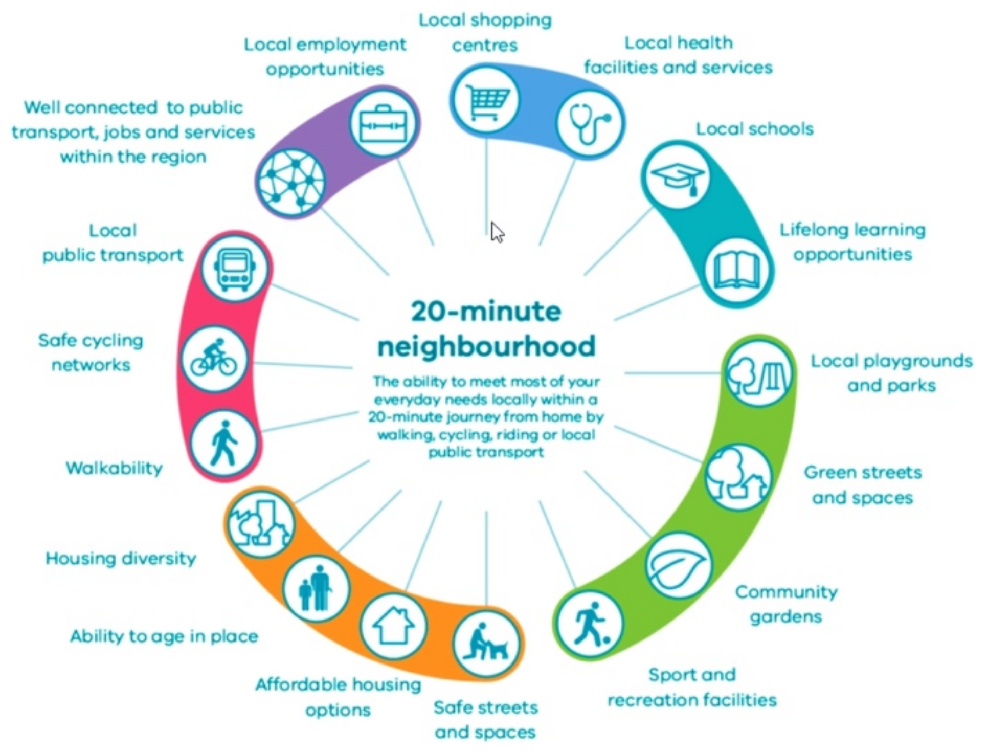
2. 15-Minute Cities: Concept and Key Attributes

The unprecedented health crisis of COVID-19 along with the climate breakdown exposed the fragility of urban environments and the need for response to manage these major global shocks. As cities are struggling to cope with the second wave of the global pandemic, perhaps the most striking realization was the time spend every day commuting to work [26,27,28] as well as the lack of amenities at local level. In the effort to imagine a post-pandemic world and living under COVID-19 restrictions from February 2020, the neighborhood came into focus as the only place to fulfil essential activities. To this end a growing number of city leaders around the world embraced the idea of 15-min city (FMC), whereby most residents can fulfill their daily needs and activities within 15 min of walking or cycling. Recommendations by C40 Cities, an international coalition of mayors focusing on climate change and sustainability, suggest that the idea of FMCs could help urban areas recover from the financial devastation of COVID-19. In fact, the newly released Mayors’ Agenda for a Green and Just Recovery specifically mentions the idea of FMC as a framework of rebounding and reaffirming the commitment of cities to the Global Green New Deal (the Global Green New Deal provides a set of principles in relation to protecting environment, strengthening economy, and building a more equitable future by (a) cutting emissions from the sectors most responsible for the climate crisis to keep global heating below the 1.5 °C goal of the Paris Agreement and (b) putting inclusive climate action at the heart of urban decision making. Source: C40 Cities: Mayors’ Agenda for a Green and Just Recovery. Available online: https://bit.ly/3l7r5yU (accessed on 5 January 2021).) [4].
In an FMC, all citizens are able to meet most or all of their needs within a short walk or bike ride from home. It is intended to function as a model of reconnecting people to their neighborhoods and localize city life. In terms of physical planning, FMCs are heavily based on attributes that have been used as design flagships in the past, namely accessibility, walkability, density, land use mix and design diversity. Perhaps the main difference in relation to other neighborhood centered approaches is that FMCs intend to bring activities to the neighborhoods and not people to the activities, restoring the urban planning concept of proximity. Proximity or even better geographic proximity, meaning the location of people, services, and activities near one another, is one of several principal ways for people to access spatially distributed opportunities in the urban environment [29]. Hence, proximity centered strategies, which are rather different from accessibility centered strategies, introduce people’s local access to a wide range of amenities important for quality of life as a core spatial planning principle. Such amenities include healthcare facilities, preschools and schools, social services, commercial services, leisure, cultural and entertainment amenities, parks and natural areas, this list being indicative rather than exhaustive [30]. Achieving proximity to all these amenities implies a great deal of decentralizing services and facilities locally, in order to equilibrate differences between districts citywide. This in turn assumes a hierarchical order of public services and appropriate transport network for efficient organization of the associated facilities, based on facilities’ market range and threshold populations [31].
In addition to the localization of a wide array of amenities, FMCs aspires to localize workplace. Localizing workplaces is equally vital as localizing any other urban function. As the trip from home to work comprises the main and most inelastic everyday trip, localizing workplaces appropriately is imperative in reducing emissions and diminishing transferability of COVID-19. The roots for the functional separation of workplaces from home lies back in the modernist era where urban activities are treated as typological categories that require rational management. The construction of functional cities was based on the separation of four basic functions residence, work, leisure and circulation creating urban forms that are still recognizable in a lot of contemporary cities. Hence, even before the health crisis, a key debate among city planners was how to create urban environments that would eliminate the home-workplace mismatch. If something positive can be attributed to the new order of things that COVID-19 enforced upon us is remote digital working. This implies a shift in traditional office function and rigid workplaces, to a range of different or hybrid work styles, based on what people like or need to do. In the neighborhood context, this could be manifested as new office space added locally, creating co-working hubs or repurposing existing office space serving the needs of local community [32].
Apart from the critical design principles, FMC aspires to engage an inclusive and egalitarian approach to planning such as to achieve socially sustainable urban environments. Sustainability of community is highlighted as an important feature that should be built through equal access to facilities and opportunities, local social interaction, participation in local community activities, community stability, pride of place, sense of belonging and feeling safe and secure. The notion of inclusiveness refers to basic urban services and amenities that include access to quality affordable housing, mobility infrastructure for all ages and abilities, affordable transportation options, equal opportunities to employment and education, and the right to lead a healthy life. Finally, FMCs are intended to be urban environments that would enhance opportunities for resident interaction in neighborhood public areas, such as sidewalks and open spaces, encouraging a sense of connection and familiarity. Participation in local collective processes and “bottom-up” dynamics developed through citizen participation as part of the spatial planning process itself, are also significant. Hence, engaging local communities in all stages of the planning process, from shaping the neighborhood vision, to selection and application of local projects is critical. The process is intended to be inclusive particularly to low-income and marginalized communities as well as to small and medium-sized local enterprises, to ensure that the plan is grounded in the neighborhood’s real issues as perceived and recorded by the users of space. This is in alignment with the bottom-up promotion of wellbeing and ensures that the plan has a broad base of support.

3. Methodology

The wider context and evaluation framework adopted by this paper includes three key concepts: inclusion, safety and health. The deliberate choice of these concepts composes an alternative evaluation context that goes beyond the platitude of the general framework of urban resilience and sustainability of cities and focuses on essential attributes that constitute and strengthen the concept of neighborhood as a “place”. At this point it is useful to clarify why we use the term of place instead of space. There is an essential differentiation between them. Space is an abstract condition. It is a simple, blank context and its values is based on its content. The abstract space by itself has no character nor special physiognomy. These two elements appear from the moment that the presence of man with his activities concretizes the space by filling it with humanizing forms, functions, dreams, expectations, emotions and personal meanings. Then the space turns into a place [33]. The use of the term place in this paper is an acknowledgement to the significance of the human factor in shaping the future of neighborhoods and cities. Hence, the proposed evaluation framework focus on the effectiveness of spatial planning not only as a design intervention to improve the quality of the built environment, but as a bottom-up process for creating safe and equitable societies as they are realized in space through co-planning practices.

3.1. The Three Evaluation Pilars

3.1.1. Inclusion

Critical urban issues such as economic instability, climate crisis, reproduction of social inequalities, socio-spatial segregation as well as the recent COVID-19 pandemic seem to require inclusive practices in achieving the wellbeing of all residents and users of space [34]. Hence, the quest for creating secure and egalitarian societies, where all citizens have equal rights, regardless of gender, age, cultural background or ability, including access to services, highlighted the concept of inclusion as an important quality feature in spatial planning.
This paper is concerned with the spatial manifestation of non-inclusiveness that is usually presented through gentrification, ghettoization and socio-spatial segregation phenomena. It adopts the World Bank’s multi-dimensional approach to inclusive planning that comprises spatial, social and economic aspects [35]. The social dimension concerns the crucial role of the social integration of individuals, especially those at risk of social exclusion. Inclusive societies provide employment and housing for everyone to ensure economic prosperity that will in turn contribute to the reduction of crime, violence, and poverty. In economic terms, inclusion concerns the issue of providing equal opportunities to employment, education, lifelong learning, financial resources etc., and to ensure a fair share in rising prosperity. The spatial dimension concerns accessibility to affordable housing, transportation options, urban services and amenities and to the regulation and control of available land and housing stock.
Finally, it is important to note that, above all, inclusion refers to the “right in the city” of the people where active participation even through insurgent practices, becomes part of the production of space, neighborhood and society. Co-planning practices and participation in decision-making is considered to be an essential part of the production of space in order for the cities to meet the multiple and complex environmental, social and economic problems. Inclusiveness is to be able to “hear” the voice of the residents through deliberation, co-design and cooperation in the decision-making process with local authorities and stakeholders. It also takes into account the opinion of all local groups and especially those who experience conditions of socio-spatial exclusion such as people with different cultural backgrounds, mobility difficulties, the elderly, young people and students, in order to reduce their vulnerability through empowerment programs.

3.1.2. Health

The second pillar is related to the assurance of healthy urban environments both spatially and socially. The World Health Organization’s definition of a healthy city refers to “the city that continuously creates and improves the natural and social environments and expands the social resources, which enable people to support each other in carrying out all the functions of life and to develop their potential to the maximum” [36].
It is undoubtable that the health of people living in urban areas is at risk due to air pollution and the effects of global warming. According to the European Environmental Agency, the increase in temperature is mainly due to the increase in atmospheric concentrations of greenhouse gases as a result of emissions from human activities [37]. Specifically, it states that in the absence of drastic measures, global temperature is expected to increase by 1.5 °C between the years 2030 and 2050 [38]. This finding in combination with other global challenges such as the rapid growth of global urban population, urban development at the expense of the rural or natural landscape, immigration as well as the increase in livestock, result in production of multiple problems and risks to human health. Finally, noise pollution is added to the pressures on cities, for which, if no action is taken it is expected to be the next public health risk by 2100 [37].
In particular, air pollution in cities is a major threat to public health, ecosystems and the climate, with direct consequences for the society and the economy [39,40]. It is estimated that indoor and external pollution causes 7 million premature deaths each year from diseases such as lung cancer and other cardiorespiratory problems [39], with lower income groups being the most vulnerable and at risk on a daily basis [40]. Therefore, policies to increase micro-mobility, reduce travel distances to meet basic needs, increase the use of mass transit, change consumption patterns to reduce industrial production and strengthen the circular economy are necessary to manage increased CO2 and carbon emissions and improve air quality [40].
Another underestimated issue in spatial planning that is directly related to citizens’ health is the lack of access to healthy and affordable food. In literature this is referred as “food deserts, indicating a geographic area that lacks sufficient access to grocery stores, especially in low-income communities [41]. A recent study in the USA indicated that racial and economic disparities in food access remain a considerable concern, with around “30 percent more non-white residents facing limited access to food retail than white residents” [42]. This percentage is higher when access to healthy affordable food is considered. The issue of sufficient access to healthy food has gained momentum both during the COVID-19 crisis and into the recovery phase of the pandemic. According to the World Food Program COVID-19 has increased vulnerable populations with restricted access to food, particularly among the newly unemployed, whose livelihoods have been disrupted, and those homebound due to quarantine. At the same time there were significant problems on the food distribution network at all levels of the food system and food supplies into the cities that had consequent effects on catering healthy products in stores [43]. It is of particular interest to note that during the quarantine, fresh and quality food was found in the local/neighborhood markets. Nevertheless, unavailability of such markets especially in low-income neighborhoods resulted in increased population vulnerability [43]. All of the above highlight the importance of eliminating the phenomenon of “food desserts” that in crisis such as the recent global health crisis, increases the vulnerability of specific groups and society in general. Spatial planning is perhaps the most appropriate tool for mitigating the phenomenon of “food desserts” by designing transport infrastructure for the distribution and supply of food at the neighborhood level, providing space for development of open-air markets and community gardens, as well as locating relevant land uses at the topical level.
Finally, a key component for ensuring healthy urban environments is the quantity, distribution and accessibility of public and green spaces [44]. It is widely accepted that green spaces promote physical activity through “walkability”, contribute to social and psychological well-being, improve air quality, and contribute to noise reduction [45]. In fact, physiological investigations of the Japanese “Shinrin-yoku” (taking in the atmosphere of the forest), highlight the therapeutic effects of nature by lowering significantly blood pressure, pulse rate and salivary cortisol concentration, bringing the body to “….a state of extreme relaxation and stress-relief” [46]. Furthermore, the social role of green spaces is very important as they contribute to the reduction of inequalities in health issues by providing access to infrastructure and benefits to all, regardless of social and age groups. Finally, a study by the World Health Organization in 2016 confirms the positive contribution of green spaces in reducing the rate of epidemic transmission [45]. In fact, in the midst of the COVID-19 green spaces have emerged as areas of vital importance for maintaining the physical and mental health of residents [47], as well as building community and neighborhood relationships. However, in order to reap their multiple benefits, a wider perspective that considers green and open spaces as part of a larger city-wide network, as well their possible multifunctionality qualities, is required [44]. Studies suggest that spatial planning can play a significant role in supporting the implementation of nature-based solutions and manage tradeoffs and conflicts [44,48]. To do this it is imperative to recognize cities as shared habitats and use multi species approach. Green and blue infrastructure are considered as fundamental tools for delivering ecosystem services in urban areas [49].

3.1.3. Safety

The third pillar is safety of urban environments. In the contemporary urban landscape and especially once COVID-19 reached pandemic proportions, the concept of safety refers to something more than the fight against crime or violence and concerns also mobility, public space, and socialization.
Safety in mobility, especially pedestrian and micro-mobility, is a key component in urban planning policies. Since the 1980s and as part of the gradual depreciation of the car-oriented planning culture, the concept of safety has acquired a significant role in the practices of New Urbanism and urban regeneration policies. Today, ensuring safety in mobility is achieved through design interventions in the transport infrastructure that includes the creation of a safe road network e.g., designation of speed belts, separation of traffic or provisions in regard to mass transit network and station areas [50,51]. Within the context of inclusiveness, travel safety focuses on the needs of all groups of citizens and especially the vulnerable ones such as children, women and people with disabilities. Such interventions may include restricting use of cars in certain areas while providing more space to pedestrians of all ages or banning the passage of cars outside school areas. In fact, in many cities, there are several policies promoting the combination of pedestrian networks with high quality mass transit as well as the removal of cars in an effort to reduce traffic congestion and road accidents [51].
In relation to transport infrastructure and travel safety it is important to mention the issues that have arisen due to the recent global health crisis. During the pandemic, walking, cycling and other micro and active mobility options proved to be critical in enabling more people to travel safely and efficiently around cities. In order to preserve this travel behavioral shift, it is necessary to prioritize walking and cycling over car-centered infrastructure by providing a safe environment for active mobility to flourish. Many cities have already started to physically separate micro mobility from road traffic and apply road sharing techniques [5,6,52]. The benefits of such approaches are manifold and include enhancement of active mobility, reduction of carbon emissions, as well as the development of the local economy [40].
Moreover, the recent pandemic has highlighted the inability of most cities to operate under the condition of “social distancing” which is directly related to the issue of safety in public spaces. During the pandemic the scarcity and inaccessibility of public and open spaces led to spontaneous and tactical place-sharing practices. These practices involved capturing road and pedestrian space to allocate urban activities such as leisure, entertainment, dining, walking, shopping etc. In a sense these practices maximized the value of the built environment by using space in the most efficient way to provide for the extra “distance” required during the pandemic. The flexible use of public space with allocation of temporal uses is not a new practice in urban planning. Tactical, insurgent, pop up and several other approaches of this kind have the qualities of temporality and flexibility of urban space in the core of their practices [53]. Under this notion, today more than ever in city planning history the notion of “fixed” land uses imposed by inflexible land use plans is under question.
Finally, providing public spaces where residents and visitors feel safe is a long-standing quest in urban planning. It is a multifactorial issue and several strategies and design interventions have been proposed to combat violence and crime phenomena. These included a mix of land uses that favors the continuous use of space at different times of the day, the increase of visibility during the night with the use of good lighting etc. In the present paper we emphasize how the orientation of the “city life” towards the street can achieve the sense of a safe urban environment. This is aligned with Jane Jacobs’ idea that “there must be eyes upon the street, eyes belonging to those we might call the natural proprietors of the street” [54]. Moreover, Mehaffy suggests that cities perform better when they offer some control of spatial structure to residents [55]. This is related to the varying degrees of public and private space over the day and span of our lives that needs to be in constant adjustment by the residents and visitors, in the context of a citizen-centered planning. In this approach engagement of citizens is crucial, so that they feel they have control over the space, where passive community surveillance becomes an active safety net.

3.2. Selection of Case Studies and Evaluation Attributes

In the present study a qualitative analysis of spatial strategies that included the concept of 15- or 20-min city was conducted. The strategies were chosen based on criteria that would facilitate the comparison and permit us to draw scientifically sound results. Initially a number of cities’ strategies from Europe, Australia, Asia and the United States were examined. These included Paris’s quarter-hour city, Barcelona’s superblocks, Britain’s high streets, Portland’s 20-min neighborhoods, Houston’s walkable places, Shanghai’s 20-min Town, Singapore’s 45-min city and Melbourne’s 20-min neighborhoods. From this pool of cities, the cases of Paris, Portland and Melbourne were selected. Selection criteria included: (i) the use of FMCs concept as a major spatial and functional organization element of the neighborhood unit, (ii) the adoption of the strategy as a planning doctrine, (iii) the citywide application of the concept of FMC and (iv) the implementation phase of the plan.
In order to gain a broader view of specific aspects of FMCs, a descriptive evaluation method with the characteristics of instrumental case study was employed [56]. Since the qualitative evaluation of the strategies aimed at highlighting key determinants based on the common characteristics of the case studies, the selected evaluation attributes are intended as clusters around which the discussion will be framed. For each pillar, namely inclusion, health and safety, elements related to spatial planning interventions from the physical point of view as well as the institutional, were evaluated. Specifically, the physical perspective included all the interventions aimed at (a) creating geographic proximity for people to access a variety of urban amenities, (b) enhancing active mobility options, (c) providing accessibility to transit, (d) increasing safety of urban environments and (e) improving connectivity and multifunctionality of green and open spaces. Institutional perspective included all the non-physical measures and actions that support community building, bottom-up initiatives, residents’ involvement in creating a sense of community as well as the planning process itself. Finally, an overall evaluation of the proximity attribute was attempted, based on the number and variety of key resources localized in the neighborhood scale. In particular, the study examined whether the attributes shown in Table 1 embodied in the strategies’ objectives, measures or actions (Table 1):
For all the above attributes a qualitative ranking scale was created corresponding to the number and type of implicit and explicit references of each component in the text of the city plan. References may relate to the general objectives of the strategy but mainly to measures and actions aiming at fulfilling each attribute. The quality scale adopted is as follows:
  • Weak: Implicit reference to the strategy’s general objectives and implicit reference to the implementation measures and actions
  • Medium: Explicit reference to the strategy’s general objectives and implicit reference to the implementation measures and actions
  • Strong: Explicit reference to the strategy’s general objectives and explicit reference to the implementation measures and actions

4. Analysis and Evaluation of the Strategies

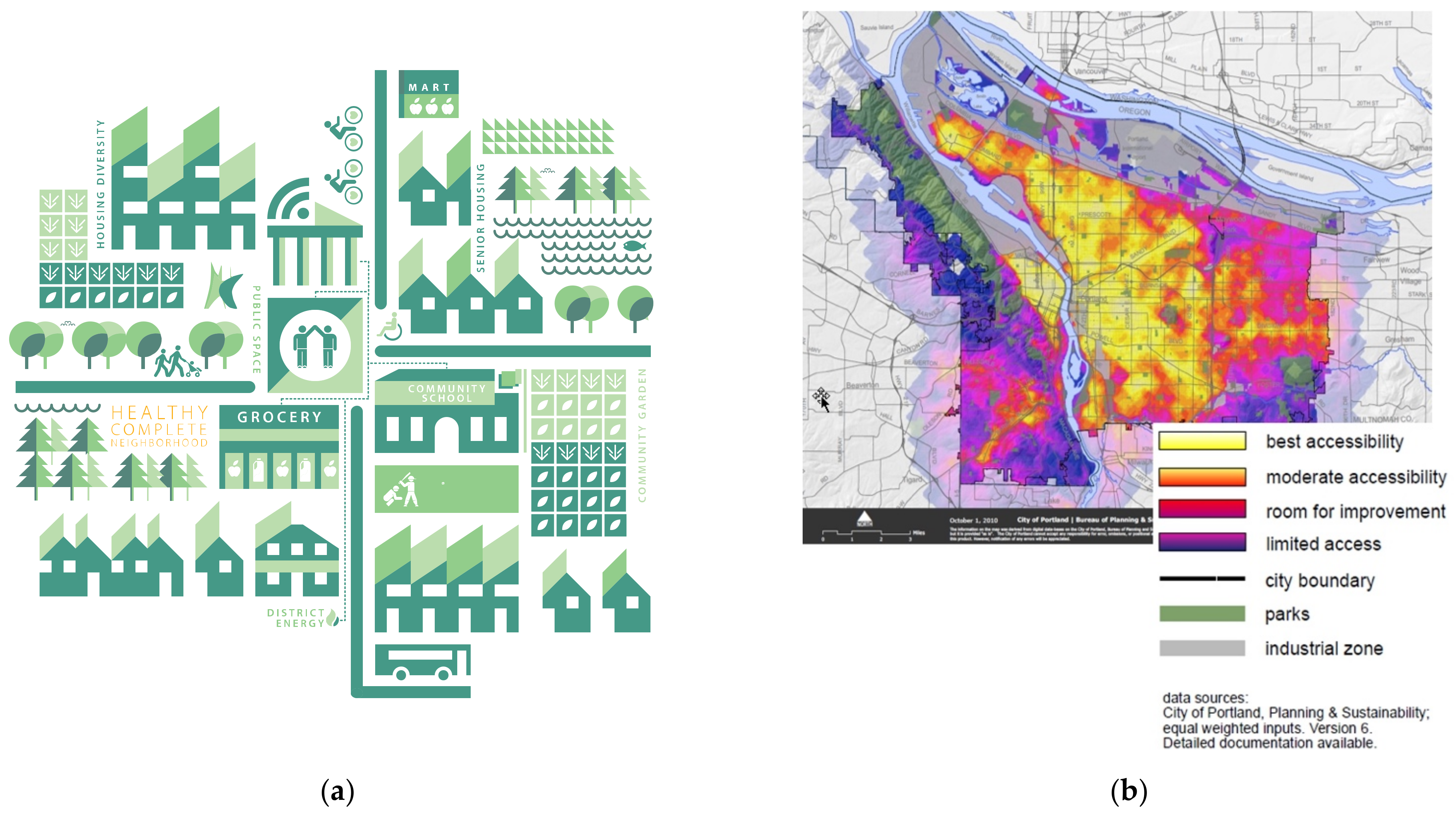
4.1. Portland: The Portland Plan

In 2012, Portland developed the Portland Plan, which was the product of a wide coalition of public and private actors and non-profit organizations. With a core set of priorities that includes prosperity, education, health and equity, the Portland Plan set long-term and short-term sub-strategies for the next 15 years. In the framework of equity, the Plan focuses on “identifying disparities to close the gaps, delivering equitable public services and engaging meaningfully with the community” [57]. The plan is articulated around three integrated strategies that include an overall goal and supporting objectives, guiding long-term policies and a five-year action plan (2012–17). The policies and actions in each strategy are grouped into strategy elements while actions and policies in each strategy element share common themes. The plan is implemented through the City’s Comprehensive Plan Update, revisions to the City’s budget, new operating practices, legislative advocacy and intergovernmental agreements. Since it was launched, the plan provided a structure for aligning budgets and projects across numerous public agencies and guiding policies up to the year 2035.
In short, the first strategy “Thriving Educated Youth” focuses on creating a culture of high expectations and achievement for all Portland youth, neighborhoods and communities that are supportive to youth, as well as facilities and programs that meet contemporary challenges and opportunities. The second strategy “Economic Prosperity and Affordability”, place emphasis on boosting urban innovation, job growth and employment opportunities, access to affordable housing and neighborhood business vitality. Finally, the “Healthy Connected Cities” strategy refers to the safety and health of citizens, the regeneration of neighborhood centers and the connection between people, places, water and wildlife [57].
The notion of the 20-min neighborhood is integrated in the “complete neighborhood” (CN) concept that falls under the goal of “Healthy Connected Cities”. Moreover, several features of the CN are interwoven into other strategies as a way to support youth success, provide access to affordable housing, promote community-driven neighborhood economic development and spur commercial activity in underserved neighborhoods. According to the plan, the term “complete neighborhood” refers to a neighborhood where one has “safe and convenient access to the goods and services needed in daily life. This includes a variety of housing options, grocery stores and other commercial services, quality public schools, public open spaces and recreational facilities, affordable active transportation options and civic amenities. An important element of a complete neighborhood is that it is built at a walkable and bikeable human scale and meets the needs of people of all ages and abilities (Figure 1).
For the application of the CN model a 20-min neighborhood index was developed in order to measure accessibility to a variety of amenities, products and services. If a neighborhood achieves a score of 70 or higher, on a scale of zero to 100, it is considered a relatively complete neighborhood (Figure 1). The goal of the strategy is that 90% of the residents to be able to walk or cycle and cover all their needs, except work, within 20 min [58]. In the calculation of the index topographical and geographical elements such as rivers and steep slopes, highways, crossroads and other natural obstacles for pedestrian movement are taken into account. It also records factors that improve the walking experience such as the presence of sidewalks, signage, diversity of routes and connections, access to high quality and frequent public transport, and proximity to core areas of services and activities [57].
CNs hold a central place in the plan as a way to promote urban environments that enhance economic vitality, inclusion, safety, health and emergency preparedness, through multiple objectives and actions. They provide a variety of urban services and public facilities in a relative dense urban environment with multiple active mobility options and in proximity to a transport node. The community centers located in each CN aim at supporting a wide range of daily basic services, at local scale.
As part of the Plan’s goal for economic development and financial resilience, CNs are intended to create a favorable environment for the development of “home” and neighborhood-based businesses that offer a variety of opportunities to enhance local employment, minority entrepreneurship, wage growth and household self-sufficiency [57]. Moreover, through the economic and prosperity strategy, CNs are key attributes for supplying affordable housing and creating equal opportunities in homeownership. CNs are also part of city’s network of hubs and connections and are considered as high opportunity areas, with improved physical accessibility and visitability, to best meet the needs for a growing and socio-economically diverse population. This includes supply of quality affordable housing of different unit types and prices, catered to low-income households, including seniors on fixed incomes and people with disabilities. The plan’s measures and actions prioritize the transformation of neglected and low-income neighborhoods and promote a housing policy that is sensitive to income inequalities. It also proposes measures to mitigate gentrification phenomena by increasing the ability of low-income households to access homeownership opportunities, promoting public investment in housing and designing housing in and around neighborhood centers and near transit—at a variety of sizes and cost ranges.
For transport there are provisions for multiple mobility options that enables affordable transportation to and from work, in and outside city limits. Multimodality is high priority, including all options that enhance active mobility. A hierarchical system of “civic corridors” and “neighborhood greenways” form the spine for a nexus for multiple urban-social functions. Civic corridors are transit corridors connecting CNs with each other, but also with the city center. Adequate access to key urban functions and proximity to major transport hubs is ensured through a network of “neighborhood greenways” that includes sidewalks, bicycle paths, greenway trails and bike-friendly green streets. It is worth noting that the strategy promotes the conversion of roads to more accessible and pedestrian-friendly activity corridors, with improved sidewalks, crossings and other pedestrian friendly facilities as a way to ensure safety. It also acknowledges that there is room for improvement for the bus system.
A strong aspect of the plan is the promotion of walking or cycling as a way to fight obesity, cardiorespiratory and chronic diseases. The plan envisages an accessible and multi-functional hierarchical system of parks, green corridors and open spaces that contributes to a healthy environment and a lifestyle that favors walking. The system of green areas is intended to cater all ages and abilities including the elderly and people with mobility issues. Side benefits include the enhancement of natural habitats and improvement of neighborhood microclimate. Moreover, provisions for alternative transport options that discourage the car usage contributes to the reduction of carbon dioxide emissions and thus respiratory diseases. Finally, amid the COVID-19 crisis more than 90 miles of busy roads have been turned into green corridors where dense tree plantation offers shade and traffic decongestion at local and citywide level [4]. This measure was intended to achieve social distancing by avoiding car usage and gathering of citizens indoors [4,59]. Moreover, implementation procedures for CM were speeded up so that 90% of citizens live in complete neighborhoods [4].
Rooted to the adopted 2009 Climate Action Plan, the network of habitat connections, greenways, parks and open space is also considered as the spine for the development of green infrastructure systems. Green and grey functions such as managing stormwater, improving water quality, reducing flooding risk and providing wildlife and pollinator habitat are realized through a green infrastructure system. It is worth noting that with the advent of the Coronavirus in 2020, the city set new priorities for long-term green infrastructure projects [4].
Access to healthy and affordable food holds a key role in the strategy, where residents of any nationality or color should have access to fresh food from small local businesses in their neighborhood. According to the Plan, in 2012 only 30% of citizens had access to a grocery store within half a mile. Hence, it proposes alternative methods for accessing fresh and culturally relevant food. Specifically, through the “Healthy Retail Initiative” there is an effort to retain and recruit a variety of healthy food sources, create community gardens and cooperatives of community agriculture.
Engaging community in the CN’s planning process and strengthening equity in decision-making is constant throughout the plan. Transparency, building capacity to participate, and providing resources for the early engagement of citizens is heavily promoted as a way to build a sense of community ownership and achieve plan’s acceptability and social legitimacy. Initiatives on building community, organizing community’s capacity and engaging people in shared governance are targeted mainly at the under-represented and underserved communities. Moreover, building relationships with public and private sector partners is considered necessary with key goals being mutual learning, exchange of knowledge and pursuit of complementary work to advance equity in decision-making.
As for the implementation of the Plan, the principles of the sub strategy “Healthy Connected City” are incorporated into the City’s Comprehensive Plan to coordinate policies, land use planning and investment decisions. Furthermore, Portland’s neighborhood centers and connections are part of the regional land use, transportation, growth management and open space system, which is coordinated by Portland’s Metro. Metro also plays a significant role in facilitating a regional strategy to promote reinvesting in existing communities.
Overall, the plan promotes neighborhood self-sufficiency, by localizing basic urban functions that include health, education, childcare, retail, recreation and fresh food production. Proximity to urban functions is supported by a hierarchical system of transport axes that includes “Civic corridors” and “Neighborhood greenways”. Nevertheless, application of the CN model implies a quite high degree of localization of activities that is not currently in place. It is not clear how the required market range and threshold populations for these activities will be ensured in a medium urban density environment. The Plan also strives for equitable access to jobs with local employment opportunities within CNs. To this end, “Complete Neighborhoods” are part of a larger network of neighborhood centers that are connected to the city center and other major employment centers. Table 2 summarizes the overall evaluation of the Portland Plan based on the three pillars.

4.2. Melbourne: Plan Melbourne 2017–2050

Plan Melbourne 2017–2050 is a long-term strategy that seeks to accommodate the challenges posed by an ever-growing population and employment. These include providing affordable and accessible housing, ensuring adequate number and diversity of jobs, containment of urban sprawl, accessibility and adequacy of transport, mitigation of green-house emissions, and adaptation to climate change [60]. The Plan is accompanied by a separate five-year implementation document, with particular focus on the short-term actions and the governance framework required for its successful implementation.
Plan Melbourne’s vision for a global city of “continuous opportunity and choice” is achieved through nine principles that include: (i) preserving the distinct character of the city, (ii) being an internationally networked and competitive city, (iii) being the focus of a network of clusters, centres, precincts and gateways, (iv) protecting biodiversity and natural assets, (v) promoting social mobility to enhance social cohesion, (vii) ensuring that neighborhoods and suburbs are diverse, inclusive, safe and heathy, (viii) building effective governance, strong leadership and collaborative partnerships and finally (vx) promoting local living in the form of 20 min neighborhoods. The strategy is articulated on 7 outcomes or strategies, 90 policies and 32 directions.
The notion of “20-min neighborhoods” is embedded in one of strategies that aims at a city of inclusive, vibrant and healthy neighborhoods. A 20-min neighborhood is defined as “giving people the ability to meet most of their everyday needs within a 20-min walk, cycle or local public transport trip of their home” and is intended to “help improve health and wellbeing, reduce travel costs and traffic congestion and reduce vehicle emissions” [60]. They are considered the means to build city wide social sustainability by promoting the well-being of its citizen through local living. According to the Plan they represent the most appropriate scale and structural element to meet basic citizen needs such as participation in activities and access to services and social infrastructure. They provide a wide array of urban and social services locally and intend to promote prosperity, health (mental and physical), social inclusion, sense of belonging, participation, choice, adaptability and employment opportunities.
In particular “20-min neighborhoods” include a series of 17 urban and social functions that should be accomplished within their jurisdictions. Figure 2 provides an overview of the proposed functions. A critical structural feature of the 20 min neighborhoods is the “neighborhood activity centre” (NAC), which is the focal point of the neighborhood (the Plan refers to them as high streets or specialized streets) and provide a variety of urban functions such as recreation, retail, services, education etc. NACs are also places of work and have the potential to be community hubs, creating an environment for social interaction and community participation. The Plan does not make specific references to the physical size of the neighborhood though it is implied that is defined by a 20-min journey of walking, cycling or using local public transport from home. According to Kagan, given the average walking time of a healthy adult and taking into account waiting at junctions and meandering routes, the distance that someone can cover in 20 min is about 800 m or half a mile [58]. Research in regard to NACs physical demarcation suggests that there are several evidence-based metrics required to inform such process, including the surrounding built environment features, placing emphasis on density features [61].
It is important to note that Melbourne’s urban development pattern was shaped by car-oriented policies. As such it consists of a low-density zonal type of development with separation of basic urban functions such as housing, working, entertainment, shopping etc. Hence, critical determinants in achieving cohesive NACs are high density development and diversity of uses in order to be able to support a variety of urban functions and optimize the value of infrastructure. Despite the fact that the issue of density is not explicitly mentioned in the principles of “20-min neighborhoods”, it is a major concern throughout the plan. The Plan emphasizes the importance of residential density and proposes raising the standards of higher-density housing. This applies to the central city, the inner and outer suburbs. Moreover, it recognizes infill and densification opportunities through renewal strategies in residential areas, activity centers, employment and innovation clusters and railway stations located on the principal public transport network. Finally, the Plan promotes the development of a diverse mix of uses locally (in NACs), that includes shops, education facilities, places of entertainment, sports and other recreational and social activities.
Diversity is also promoted for mobility choices which include active mobility options like walking or cycling in combination with public transport. According to the Plan NACs are perceived as highly walkable areas. Walking or cycling in these areas is encouraged using appropriate design principles and infrastructure, mainly for local routes. Travel safety is also addressed by proposing several measures that ensure pedestrians’ and bikers’ safety i.e., bicycle lanes, school drop-off zones etc. Moreover, combing micro mobility choices with public transport aims to provide access to other activity and employment centers citywide. The Plan proposes a Principal Public Transport Network (PPTN) where high-quality public transport services are or will be provided. Hence, it is crucial to channel development of high diversity and density on and around the PPTN. Nevertheless, NACs are not explicitly linked to PPTN due to Melbourne’s low-density urban environments. In addition, given Melbourne’s sprawled type of development, public transit can be viable only in certain areas [61]. Studies for the city of Melbourne advocate that providing local public transport service in support of the NACs is quite tricky for the inner and especially for the outer suburban parts where the greatest need exists with respect to achieving a 20-min city. The use of demand responsive and flexible transit service is suggested as a viable solution, especially for the outer suburbs [62]. Therefore, local public bus service is considered as the primary mass transit option since it could offer adequate service level that can be economically justified.
Managing and supplying new housing in the right locations to meet population growth and create a sustainable city, is another major challenge for Melbourne. NACs and its surroundings are designated as places where an increased percentage of new housing is channeled. Not all NACs are appropriate, therefore there is a priority plan depending on the proximity to existing services, jobs and public transport. As built environment features surrounding NACs must reach certain density levels, a minimum of 25 dwellings per hectare is suggested [63,64]. Regarding the issue of affordable housing, the Plan pursues equal accessibility opportunities to all income and social groups, seeking to reduce inequalities within the city [3,59,63].
Promoting healthy lifestyles is achieved through increased physical activity opportunities and development of a network of green spaces. In fact, the plan aspires to increase walkability options with the full pedestrianization of NACs and the use of pedestrian-friendly infrastructure with access for all ages and people with disabilities [58,65]. In addition, green areas provide more places for rest and recreation, as well as space for social interaction and connection with the natural environment. In this network of accessible and high quality local open spaces, other types of spaces, such as schoolyards, can be included to offer space for other activities i.e., sports and vice versa. Community landscaping, revegetation and gardening is part of the Plan’s intention to provide opportunities for sharing skills and knowledge, increasing social interaction and community partnerships and producing local food for personal consumption or for sale at local markets. Citizen’s involvement in such activities is a prerequisite to increase awareness of the value of open public space. Amid COVID-19 crisis it was decided that a large amount of plant species (approximately 150,000) would be planted, and new habitats were proposed as a way to stimulate biodiversity and create new low skilled jobs [4].
Special emphasis is given to the provision of social infrastructure locally, as a way to combat car-dependent travel patterns, contributing the most to the realization of the 20-min neighborhood model. Proximity to basic social infrastructure includes schools, kindergartens, early years centres, parks and playgrounds. For the accommodation of a variety of social needs the Plan proposes the use of spaces in a temporal, flexible and adaptive fashion as well as co-location of complementary activities, in order to maximize localization of educational, health and recreational urban functions.
As for the implementation of the plan, Plan Melbourne is a quite mature strategy and has gone through pilot implementation projects in three neighborhoods involving local government, stakeholders and the Resilient Melbourne office. Results highlighted the significance of “bottom-up” approaches and co-planning practices as a way to acknowledge the real local problems and acquire long-term commitment of local communities to the plan.
Overall, 20-min neighborhood is promoted as a new urban development model in order to contain sprawl and create diverse urban environments and housing opportunities. The plan proposes a network of neighborhoods with a certain degree of self-sufficiency, by localizing basic urban functions that mainly include education, childcare, retail, recreation and fresh food production. Application of the 20-min city model implies a moderate localization of basic public functions and their assorted facilities that is not currently in place. However, due to the sprawled urban development patterns and the lack of appropriate transit options, NACs could present different proximity opportunities and realization possibilities. Densifying urban environments in the inner and especially the outer suburbs is probably the greatest challenge for the implementation of the NAC scheme. Moreover, it is quite clear that not all NACs have direct access to quality public transport, therefore it is imperative to facilitate such access as a way to connect people to jobs and higher order services. Otherwise, there is a high possibility that NACs would function more as “pedestrianized islands” in an urban sprawl ocean, rather than proximity cores to urban functions.
Methodologically speaking the Plan does not specify how to measure or define the 20 min radius probably due to the variety of existing housing and activity densities citywide. This implies the need for a methodology that would take into account the different types of development, especially in the inner and outer suburbs. Finally, the Plan does not identify the standard urban functions and associated infrastructure facilities that are localized in each neighborhood. This presents a weakness in terms of evaluating the state of existing neighborhood centers that can function as NACs and the associated improvements. Table 3 summarizes the overall evaluation of the Melbourne Plan based on the three pillars.

4.3. Paris: Paris en Commun

The Paris En Commun strategy visions a great Paris without borders and increased community involvement. It is rooted in the Paris Climate action plan, the flagship of Mayor Hidalgo’s re-election campaign in 2020, addressing climate change challenges with the revival of Paris’s neighborhoods. In the context of the implementation of the plan, various policies have been adopted with emphasis on reducing car dominance, regaining space from cars, increasing tree canopy and enhancing pedestrian mobility [7,66]. One of the notable elements of this strategy is the importance it gives to the participation of citizens in visioning and implementing the plan, as evidenced by the funds that have been allocated for conducting participatory planning processes. Finally, the strategy most recently acquired new attention as a post COVID-19 recovery strategy, reintroducing the concept of the quarter-hour city [4,66].
The vision of Paris En Commun strives for a carbon-free economy and a healthy life for its citizens [67]. It concerns the area of Paris that is confined within the ring road, aka peripherique. The four axes of the strategy include the implementation of ecological measures, solidarity-centered ecological transformation, hyper-proximity and the commitment of citizens to the strategy [68]. The 15-min concept falls under the hyper proximity axis, as an attempt to create a neighborhood centered city where all inhabitants can cover most of their needs with 15 min, walking or biking, from their place of residence [7,68]. The philosophy of quarter-hour city is based on 4 principles: proximity, diversity, density and ubiquity, where neighborhood development must cover six primary social functions: housing, employment, shopping, health care, education and entertainment (Figure 3a) [69].
The strategy mentions that the quarter-hour city aims at providing hyper-local self-sufficient arrondissements that will ensure “….dwelling in dignity, working in proper conditions, [being able to gain] provisions, well-being, education and leisure” [58]. Since high building density is already a given for Paris, the strategy focuses on the mix of uses including housing with shops, entertainment with medical centers and offices with educational buildings [7,58]. Moreover, the quarter-hour city envisages transformative public and semi-public spaces having multiple properties such as schoolyards being able to be converted into sports venues or simply cool places where residents can use during summer nights, weekends or during school holidays. A network of “citizen kiosks” staffed by city employees operate as central multifunctional nodes of communication, exchange of information and service of neighborhood residents. Functions may include simple things like drop off and pick-up keys, join a local club, exchange and reuse of products in application of the circular economy practices, as well as the development of voluntary actions such as supporting sensitive community groups.
The notion of localizing services and functions is evident throughout the plan. Initiatives such as “eat and buy local” promote the consumption of products that have been produced in the “basin” of Paris. In fact, the strategy proposes the creation of cooperatives like the “Agri-Paris” which acquires fresh food and other products from local producers and distributes them quickly and directly to the residents and neighborhood markets of Paris. In addition, small businesses “made in Paris” are also encouraged to enhance development of local entrepreneurship [7,68,69]. Self-sufficiency of households and the neighborhood is also promoted through special programs for improving literacy and unemployment rates. Specific training programs, second chance schools and flexible facilities such as babysitting, aim at helping low-income residents to prepare for local jobs i.e., in circular economy, reuse and item repair, accounting etc.
The quarter-hour city is intended to be a favorable environment for localizing job opportunities and enhance local employment. In fact, in the C40 Mayors’ agenda for the green and fair recovery of the planet by COVID-19, there are several references to enhance remote working and promote the co-location of companies and “relocation” of workplace within the neighborhoods [4]. This of course implies a great flexibility in terms of opening hours of several local services as well as flexibility in the usage of space itself.
Given that the city of Paris has a well-developed transit system and adequate urban density for a highly walkable environment, the strategy focused on bringing activities to the neighborhoods. Thus, it prioritizes the pedestrianization of large parts of the city along with alternative active mobility options. Neighborhoods in and around the centre of Paris are suggested to be inaccessible to the car, with the exception for the disabled, residents, shopkeepers, taxis, electric buses and emergency vehicles. It also intends to create “children’s roads” next to school units where traffic is banned during the school opening and closing hours [54]. An additional plan of 300 million euros already in working progress proposes an integrated network of bike lanes, pedestrian and bike friendly roads and green routes (Figure 3b). The plan aims to serve most of the mobility needs within the peripherique and change mobility habits in the long run. Specifically, the plan aims to increase, by 2024, the network of bike lanes by removing 60,000 parking spots while each road will have a bike lane. Other measures for changing city’s mobility culture include co-boarding, common means of transport (“transports en commun”), electric buses, skates, and extension of operating hours of public transportation (bus and metro). Part of this network are the recently pedestrianized highways that run through the centre at either side of the River Seine. Finally, amid COVID-19 the city installed a regime of “corona cycleways” to alleviate transit crowding and discourage the use of car for commuting purposes. Recent images from the city show an almost Copenhagen-like renaissance of urban bicycling [58].
Providing inclusive and diverse housing is probably the greatest challenge for the quarter hour city. In particular the Resilient Plan for Paris mentions that over the next 30 years, the city will continue to accommodate new residents, with an additional 200,000 Parisians expected between now (2018) and 2050. On the other hand, there has been a decline in housing accessibility and affordability due to gentrification and real estate speculation. To cope with the housing shortage the strategy aspires to increase its housing supply by having 30% of its housing stock in the public domain until 2030, and ideally to increase the share in high end districts. Furthermore, tax incentives related to vacant dwellings and second homes intend to put dwellings back on the market. Transformation of office space into housing is also considered while co living is promoted as a way to reduce housing costs and create social links between generations [70].
In the context of mitigating the effects of climate change and reducing air pollution the strategy aims at a greener city. Greening is also related to the preservation of biodiversity within the city in an effort to enhance local habitats and biodiversity. Thus, a network of green corridors, new urban forests, short walking routes, large artificial plantation vessels and new parks are proposed. As for the building stock, there are a variety of measures concerning reduction of energy consumption, which include installing solar panels, planted roofs, rainwater harvesting facilities etc. Composting, recycling and waste separation at local level, as well as zero garbage production are parts of the strategy’s intention to build a collective ecological consciousness [68]. In terms of green infrastructure there is no explicit reference to them, but the strategy is related to the respective Resilience Strategy that foresees the creation, conservation and enhancement of a quite wide range of green infrastructure assets, though without any provisions of connectivity amongst them [71].
Paris En Commun involves citizens at various stages of the planning and implementation of the quarter-hour city. It is worth noting that 5% of the total budget of the strategy has been provided to enhance citizens’ participation in both decision-making and co-planning of their neighborhoods. Indicatively, since 2014, 2428 projects have been implemented from the “participatory budget” (Budget participatif de la ville de Paris), while the “municipal kiosk” has also a role in receiving and promoting residents’ proposals for funding through the participatory budget [68].
Overall, the strategy of Paris en Commun uses the notion of “Hyper Proximity” to reconstruct the city as a patch of socially and culturally reach neighborhoods. Since the densely developed urban core provides for the most needed building density, the strategy focusses on improving the diversity of uses and creating an integrated mixed used urban fabric. Balancing the distribution of facilities amongst the 20 districts is a primary goal. By providing basic services at the local level, it is expected that all neighborhoods will have a variety of shops, homes, primary health and education services, offices and recreation opportunities, achieving the localization of important urban functions, strengthening each neighborhood as an entity. In general, locality and inclusion are evident in the proposed mix of land uses, with which residents group their activities around areas that once had only one use, while mixing of public and semi-public functions produce flexible public spaces and facilities.
Nevertheless, Paris has to counterbalance the risk of creating a socially polarized city. Paris en Commun is a plan concerning the inner ring area, only a part of the Greater Paris Metropolis, inhabited mainly by affluent Parisians and with property prices that rose even during the pandemic [72]. Greening and pedestrianizing large parts of Paris may impose great challenges in providing inclusive and diverse housing and make the city of Paris inaccessible to lower-income suburban commuters [72]. Table 4 summarizes the overall evaluation of the “Paris en Commun” plan based on the three pillars.

5. Discussion

The idea of 15-min cities seems to have stirred up planners’ imagination and politicians’ willingness for providing us with a new planning eutopia. Amid COVID-19 crisis when the need for imagining the post-pandemic city emerged, 15-min cities came into focus as an urban development model for the economic rebound of cities through an egalitarian perspective [4]. In this model, the neighborhood holds a critical role as the spatial context in which residents meet their basic needs, interact and communicate with each other. Since the neighborhood has been historically regarded as a vital element for the spatial and functional organization of cities, the question posed here is, what is new in the FMCs approach? Careful examination of the application of the idea of FMC in three prominent case studies, highlighted the novelty elements, the prerequisites and the possible pitfalls of the proposed model.
FMCs seems to have common grounds with other neighborhood centered approaches, which can be condensed in their general scope as “being places able to reconnect people to local areas and localize city life”. In terms of physical planning FMCs are heavily based on attributes that have been repeatedly used as design flagships in the past, namely accessibility, walkability, density, land use mix and design diversity. The novel element is that FMCs are putting the notion of proximity to resources, instead of accessibility to resources, into the core of their land use and transport planning policies. A closer look to the idea of FMC suggests that it presents an opportunity to rethink about resource allocation in a citywide scale. Optimal resource allocation in the context of a neighborhood environment applied citywide or even regionally is not a new idea. It roots back to the basic concept of proximity to uses which entails a great scale of localization of primary urban functions. This assumes a hierarchical order of public services that presumes the “Christallerization” (from Walter Christaller and his Central Place Theory) of urban space, where neighborhoods are part of a system rather than simple hierarchies or single entities. The notion of proximity does not necessarily clash with accessibility but brings into focus the concept of self-sufficiency of an area, meaning providing a wide array of services locally rather than providing efficient means of public transit for accessing these amenities elsewhere in the city. Nevertheless, application of proximity as a primary organizing principle of urban space includes the trivial task of redistributing functions based on several geographical, economic and social principles like threshold population, market range etc. Moreover, it requires transferring power to the lower governmental system, as well as citywide policies for hierarchization and relocation of public functions.
Technical issues in regard to how we define and measure proximity to key urban amenities are critical, since they define the core and range of influence of the neighborhood unit. For key urban functions and localized amenities, it is imperative to audit and classify critical community infrastructure and their different catchment areas as well as other proximity related factors [30]. This includes primary community infrastructure serving the social needs as well as infrastructure for accommodating newly appeared community needs. In regard to the three case studies, it is quite safe to state that they adopt a mentality that is closer to the notion of accessibility rather than proximity. Portland and Paris identify the standard urban functions to be decentralized in each neighborhood, while Melbourne fails to do that systematically due to the sprawled urban development patterns. Furthermore, Portland presents a quantitative methodology for assessing accessibility, and not proximity, to these functions, while Paris seems to embrace the notion of proximity to uses, but without any reference to the quantitative prerequisites. Finally, all three case studies perceive neighborhoods as part of a larger network of neighborhoods centers but with no reference to the hierarchical order of the attempted resource allocation citywide.
Perhaps in the most optimistic aspirations of the FMC model, someone would include its ambition to address a long standing fundamental spatial planning issue; this of the mismatch between the location of jobs and housing, especially affordable housing for low-income workers. Recently, in the C40 Mayors’ agenda for the green and fair recovery of the planet from COVID-19, the localization of employment opportunities was introduced as a means to rebuild areas economically hard-hit by the pandemic [4,73]. In this context, FMCs are seen as places for creating employment opportunities locally, as well as remote working. The city strategies examined in this paper recognize the importance of creating local employment opportunities but not always propose the necessary measures and actions to achieve it. Portland Plan has a specific strategy for the development of employment districts as places of work that include central city, industrial districts, harbor, hospitals, universities, and other commercial centers. Hence, the plan mostly focuses on providing equitable access to jobs by linking neighborhoods to employment centers with multimodal transit options. Melbourne plans to facilitate investment and create job clusters in the outer city areas as a way to increase local access to employment and ensure that employment growth occurs in designated locations outside the central city. At the same time new housing is channeled to existing job clusters that are located in the outer suburbs contributing to the goal of reducing commuting times to employment. However, due to the low dense urban environment, many people will eventually have to travel outside of the NACs for their jobs. Finally, Paris is taking advantage of being in the center of a metropolitan conurbation and examines the potential to apply more flexible working schemes. The application of remote working and coworking schemes implies practices of co-location of companies and “relocation” of workplace within the neighborhoods. In order for this to succeed it requires great flexibility in the operating hours of several local services as well as flexibility in the usage of space itself [3]. More importantly, such fundamental changes presuppose new employment allocation models that cannot be accomplished without coordinated efforts and dialogue with the corporations and companies, so as to encourage them to downsize their central offices, transform their work style to more hybrid modes and reduce the right of presence of employees in physical workspaces.
Finally, high accessibility to certain areas and the creation of hyper proximity cores are usually accompanied by rising property values, causing either gentrification phenomena or the confinement of lower income households to periphery [8,74]. Hence provisions in regard to affordable and rental housing, available to diverse individuals and households, are critical and should be an integral part of FMCs policies. The three case cities, though each in different context, acknowledge the critical issue of providing equal opportunities in homeownership. Portland presents a concrete and mature plan of measures and actions to mitigate gentrification phenomena and provide affordable housing. The city of Melbourne is also concerned with the issue of providing equal opportunities to affordable housing but mainly strives to ensure the minimum urban density requirements in the new housing developments. Finally, Paris is probably facing the greatest challenge in providing inclusive and diverse housing. The proposed housing policies are oriented towards less traditional practices that include flexible use of space, co living and tax incentives strategies.
When it comes to the spatial planning process itself, FMC aspires to engage collective processes and “bottom-up” dynamics developed through inclusive and meaningful citizen participation. In the three case studies, development of FMCs is perceived as a community project, therefore building capacity to participate and providing resources for the early engagement of citizens were a primary concern. Furthermore, acknowledgement of the real local problems through community engagement was used as a way to achieve transparency and build a sense of community ownership and legitimacy of the plan. Finally, the importance of this aspect is reflected in all three plans with the extensive budget allocation committed to the coordination of planning through community partnership approaches.

6. Conclusions

FMCs is neither a radical nor a -fit for all- idea. It requires a mix of physical and non-physical attributes based on the unique urban and social form, legislative provisions and governance structure of each city. It uses long established urban planning principles to achieve a bottom-up promotion of wellbeing, acknowledging the significance of neighborhoods as “intimate places” rather than “unfamiliar spaces”, comprising complex social interactions. In this context it proposes an alternative way to think about optimal resource allocation in a citywide scale, where bringing activities to the neighborhoods rather than people to activities becomes the main objective. This implies a shift in the emphasis of planning from the accessibility of neighborhood to urban functions to the proximity of urban functions within neighborhoods, along with large systemic changes in resource allocation patterns and governance schemes in city- and metro-wide scale.

Author Contributions

Conceptualization, G.P.; methodology, G.P. and Z.C.; investigation, G.P. and Z.C.; writing—original draft preparation, G.P.; writing—review and editing, G.P. All authors have read and agreed to the published version of the manuscript.

Funding

This research received no external funding.

Conflicts of Interest

The authors declare no conflict of interest.

References

  1. Patricios, N.N. Urban design principles of the original neighbourhood concepts. Urban Morphol. 2002, 6, 21–36. [Google Scholar]
  2. Duany, A.; Zyberk, E.P. The Traditional Neighborhood and Urban Sprawl. In New Urbanism and Beyond. Designing Cities for the Future; Haas, T., Ed.; Rizoli International Publications: New York, NY, USA, 2009; pp. 64–66. [Google Scholar]
  3. Boucher, L. The Urban Developer. Local Living, Rise of 20 Minute Cities Post-Covid. Available online: https://theurbandeveloper.com/articles/local-living-rise-of-20-minute-cities-post-covid (accessed on 27 November 2020).
  4. C40 Cities: Mayors’ Agenda for a Green and Just Recovery. Available online: https://bit.ly/3l7r5yU (accessed on 20 September 2020).
  5. C40 Cities: How to Build Back Better with a 15-Minute City. Available online: https://rb.gy/kmtpmg (accessed on 18 September 2020).
  6. CityLab Daily: Is the ‘15-Minute City’ Key to Covid Recovery? Available online: https://www.bloomberg.com/news/newsletters/2020-07-16/citylab-daily-is-the-15-minute-city-key-to-covid-recovery (accessed on 19 September 2020).
  7. O’Sullivan Paris Mayor: It’s Time for a ‘15-Minute City’. Available online: https://www.bloomberg.com/news/articles/2020-02-18/paris-mayor-pledges-a-greener-15-minute-city (accessed on 12 September 2020).
  8. Weng, M.; Ding, N.; Li, J.; Jin, X.; Xiao, H.; He, Z.; Su, S. The 15-minute walkable neighborhoods: Measurement, social inequalities and implications for building healthy communities in urban China. J. Transp. Health 2019, 13, 259–273. [Google Scholar] [CrossRef]
  9. Li, Z.; Zheng, J.; Zhang, Y. Study on the Layout of 15-Minute Community-Life Circle in Third-Tier Cities Based on POI: Baoding City of Hebei Province. Engineering 2009, 11, 592–603. [Google Scholar] [CrossRef] [Green Version]
  10. Kafkalas, G.; Vitopoulou, A.; Gemenetzi, G.; Yiannakou, A.; Tasopoulou, A. The City as an evolutionary process. In Sustainable Cities: Adaptation and Resilience in Times of Crisis; Hellenic Academic Ebooks: Athens, Greece, 2015; Available online: http://repository.kallipos.gr/handle/11419/2227 (accessed on 12 September 2020).
  11. Perry, C.A. The neighborhood unit: A scheme of arrangement for the family-life community. Neighborhood Community Plan. Comm. Reg. Plan N. Y. Its Environ. 1929, 7, 2–140. [Google Scholar]
  12. Isaac, R. The Neighborhood Theory: An Analysis of its Adequacy. J. Am. Inst. Plan. 1948, 14, 15–23. [Google Scholar] [CrossRef]
  13. Bauer, C. Good Neighborhoods. Ann. Am. Acad. Political Soc. Sci. 1945, 242, 104–115. [Google Scholar] [CrossRef]
  14. Dyckman, J. Comment on Glazer’s School Proposals. J. Am. Plan. Assoc. 1959, 25, 191–196. [Google Scholar] [CrossRef]
  15. Alexander, C. The city is not a tree. Des. J. 1966, 206, 46–55. [Google Scholar]
  16. Batty, M. Building a science of cities. Cities 2012, 29, S9–S16. [Google Scholar] [CrossRef] [Green Version]
  17. Bernick, M.; Cervero, R. Transit Villages in the 21st Century; McGraw-Hill Companies Inc.: New York, NY, USA, 1997. [Google Scholar]
  18. Prouse, V.; Grant, J.L.; Ramos, H.; Radice, M. Assessing Neighbourhood Change: Gentrification and Suburban Decline in a Mid-sized City. Working Paper. Available online: https://bit.ly/3l9yCx6 (accessed on 12 September 2020).
  19. Smith, M.K. Neighborhoods and regeneration: Theory, practice, issues. In The Encyclopaedia of Informal Education; INFED: London, UK, 2011; Available online: https://infed.org/mobi/neighborhoods-and-regeneration-theory-practice-issues/ (accessed on 12 September 2020).
  20. Alexander, C. The Nature of Order; Taylor & Francis: Berkeley, CA, USA, 2004. [Google Scholar]
  21. Sanders, I. Complex System thinking and New Urbanism. In New Urbanism and Beyond. Designing Cities for the Future; Haas, T., Ed.; Rizoli International Publications: New York, NY, USA, 2009; pp. 275–279. [Google Scholar]
  22. Friedmann, J. The uses of planning theory: A bibliographic essay. J. Plan. Educ. Res. 2008, 28, 247–257. [Google Scholar] [CrossRef]
  23. Massey, D. For Space; Sage Publications Inc.: Thousand Oaks, CA, USA, 2005. [Google Scholar]
  24. Istoriou, T.; Pozoukidou, G. Public Space 20. In Proceedings of the Public Space +, Thessaloniki, Greece, 28–30 March 2019; IANOS Publications: Thessaloniki, Greece, 2019; Volume B1, pp. 169–172. [Google Scholar]
  25. Batty, M.; Marshall, S. Thinking organic, acting civic: The paradox of planning for Cities in Evolution. Landsc. Urban Plan. 2017, 166, 4–14. [Google Scholar] [CrossRef]
  26. Dudley, D. 2020 Requiem for the Super Commuter. Available online: https://www.bloomberg.com/news/articles/2020-12-31/the-pandemic-killed-my-commute-is-that-good (accessed on 3 January 2021).
  27. Kun, A.; Sadun, R.; Shaer, O.; Teodorovicz, T. 2020 Where Did the Commute Time Go? Harvard Business Review. Available online: https://hbr.org/2020/12/where-did-the-commute-time-go (accessed on 3 January 2021).
  28. Bartik, A.; Cullen, Z.; Glaeser, E.; Luca, M.; Stanton, C. 2020 How the COVID-19 Crisis Is Reshaping Remote Working. Available online: https://bit.ly/3o9fxg (accessed on 3 January 2021).
  29. Church, A.; Frost, M.; Sullivan, K. Transport and social exclusion in London. Transp. Policy 2000, 7, 195–205. [Google Scholar] [CrossRef]
  30. Solá, A.G.; Vilhelmson, B. Negotiating proximity in sustainable urban planning: A Swedish case. Sustainability 2019, 11, 31. [Google Scholar] [CrossRef] [Green Version]
  31. Rodrigue, J.P. The Geography of Transport System, 5th ed.; Routledge: New York, NY, USA, 2020; Available online: https://transportgeography.org/?page_id=97 (accessed on 23 September 2020).
  32. Everett, C. 2020 How the “15-Minute City” Will Transform Work. Available online: https://www.raconteur.net/workplace/15-minute-city/ (accessed on 30 September 2020).
  33. Stefanou, I. The Physiognomy of Place. The Character of the Greek City in the 21st Century; National Technical University of Athens: Athens, Greece, 2001. [Google Scholar]
  34. Syed, Z.S. Inclusive Planning for Social Integration: A Short Note. Available online: https://www.un.org/esa/socdev/egms/docs/2009/Ghana/inclusive-planning.pdf (accessed on 10 September 2020).
  35. World Bank. Report on Inclusive Cities Approach. Report No: AUS8539; 2015; Available online: http://documents.worldbank.org/curated/pt/402451468169453117/pdf/AUS8539-REVISED-WP-P148654-PUBLIC-Box393236B-Inclusive-Cities-Approach-Paper-w-Annexes-final.pdf (accessed on 21 September 2020).
  36. WHO. The Health Promotion Glossary. Report No: WHO/HPR/HEP/98; 1998; Available online: https://www.who.int/healthpromotion/about/HPR%20Glossary%201998.pdf?ua=1 (accessed on 7 October 2020).
  37. European Commission. Secretariat-General. The Eur. Green Deal 2019. Available online: https://eur-lex.europa.eu/legal-content/EN/TXT/?qid=1596443911913&uri=CELEX:52019DC0640#document2 (accessed on 12 September 2020).
  38. IPCC. Summary for Policymakers. In Global Warming of 1.5°C: An IPCC Special Report on the Impacts of Global Warming of 1.5°C Above Pre-Industrial Levels and Related Global Greenhouse Gas Emission Pathways, in the Context of Strengthening the Global Response to the Threat of Climate Change, Sustainable Development, and Efforts to Eradicate Poverty; In Press. Available online: https://www.ipcc.ch/sr15/ (accessed on 10 May 2020).
  39. WHO. Air Pollution. Available online: https://www.who.int/health-topics/air-pollution#tab=tab_1 (accessed on 3 October 2020).
  40. C40 Knowledge Hub. Why Clean Air Is Vital for Your City’s Health and Prosperity. Policy Briefs 2019. Available online: https://www.c40knowledgehub.org/s/article/Why-clean-air-is-vital-for-your-city-s-health-and-prosperity?language=en_US (accessed on 7 October 2020).
  41. Shaw, H.J. Food deserts: Towards the development of a classification. Geogr. Ann. Series B Hum. Geogr. 2006, 88, 231–247. [Google Scholar] [CrossRef]
  42. Karpyn, A.; Riser, D.; Tracy, T.; Wang, R.; Shen, Y. The changing landscape of food deserts. UNSCN Nutr. 2019, 44, 46–53. [Google Scholar]
  43. C40 Knowledge Hub. Food and COVID-19: How Cities Are Feeding Residents Today and Building a Better Tomorrow. Implementation Guides. 2020. Available online: https://www.c40knowledgehub.org/s/article/Food-and-COVID-19-How-cities-are-feeding-residents-today-and-building-a-better-tomorrow?language=en_US (accessed on 8 September 2020).
  44. Pozoukidou, G. Designing a green infrastructure network for metropolitan areas: A spatial planning approach. Euro-Mediterr. J. Environ. Integr. 2020, 5, 1–5. [Google Scholar] [CrossRef]
  45. Egorov, A.I.; Mudu, P.; Braubach, M.; Martuzzi, M. Urban Green Spaces and Health; WHO Regional Office for Europe: Copenhagen, Denmark, 2016; Available online: http://www.eddyppy.gr/sites/default/files/urban-green-spaces-and-health-review-evidence.pdf (accessed on 7 October 2020).
  46. Tsunetsugu, Y.; Park, B.J.; Ishii, H.; Hirano, H.; Kagawa, T.; Miyazaki, Y. Physiological effects of Shinrin-yoku (taking in the atmosphere of the forest) in an old-growth broadleaf forest in Yamagata Prefecture, Japan. J. Physiol. Anthropol. 2007, 26, 135–142. [Google Scholar] [CrossRef] [Green Version]
  47. Mental Health Weekly. COVID-19 Leads to Jump in People Seeking MH Help in NYC. Ment. Health Wkly. 2020, 30, 7. Available online: https://doi.org/10.1002/mhw.32328 (accessed on 4 January 2021).
  48. Bush, J.; Doyon, A. Building urban resilience with nature-based solutions: How can urban planning contribute? Cities 2019, 95, 102483. [Google Scholar] [CrossRef]
  49. Heymans, A.; Breadsell, J.; Morrison, G.M.; Byrne, J.J.; Eon, C. Ecological urban planning and design: A systematic literature review. Sustainability 2019, 11, 3723. [Google Scholar] [CrossRef] [Green Version]
  50. European Commission. EU Security Union Strategy. COM(2020) 605 Final. 2020. Available online: https://ec.europa.eu/futurium/en/system/files/ged/communication-eu-security-union-strategy.pdf (accessed on 4 August 2020).
  51. European Commission. Action Plan to Support the Protection of Public Spaces. COM(2017) 612 Final. 2017. Available online: https://eur-lex.europa.eu/legal-content/EN/TXT/?uri=CELEX%3A52017DC0612 (accessed on 4 August 2020).
  52. CityLab Daily: How the ‘15-Minute City’ Could Help Post- Pandemic Recovery. Available online: https://bloom.bg/33pQCgK (accessed on 12 September 2020).
  53. Istoriou, T.; Pozoukidou, G. Towards Participatory Futures. The emerging ecosystems of citizens’ initiatives in the city of Thessaloniki. In City under Construction: Plans, Practices, Processes for the City of Thessaloniki, Thessaloniki, Greece, 12–13 October 2018; Univerity Studio Press: Thessaloniki, Greece, 2018; pp. 455–465. [Google Scholar]
  54. Jacobs, J. The Death and Life of Great American Cities; Random House: New York, NY, USA, 1961. [Google Scholar]
  55. MehaffyΜ, M. 5 Key Themes Emerging from the «New Science of Cities». 2014. Available online: https://www.bloomberg.com/news/articles/2014-09-19/5-key-themes-emerging-from-the-new-science-of-cities (accessed on 30 August 2020).
  56. Bassey, M. Case Study Research in Educational Settings; McGraw-Hill Education: London, UK, 1999. [Google Scholar]
  57. City of Portland Bureau of Planning and Sustainability. The Portland Plan; City of Portland Bureau of Planning and Sustainability: Portland, Oregon, 2012. [Google Scholar]
  58. Kagan, C. The Future Is 20 Minutes Away? 20-Minute Neighborhoods. Steady State Manchester Team. 2019. Available online: https://steadystatemanchester.net/2019/11/20/the-future-is-20-minutes-away-20-minute-neighbourhoods/ (accessed on 5 September 2020).
  59. Sisson, P. How the ‘15-Minute City’ Could Help Post-Pandemic Recovery. Available online: https://www.bloomberg.com/news/articles/2020-07-15/mayors-tout-the-15-minute-city-as-covid-recovery (accessed on 30 August 2020).
  60. Plan Melbourne. Metropolitan Planning Strategy; 2017. Available online: https://www.planmelbourne.vic.gov.au/the-plan (accessed on 12 July 2020).
  61. Gunn, L.D.; Mavoa, S.; Boulangé, C.; Hooper, P.; Kavanagh, A.; Giles-Corti, B. Designing healthy communities: Creating evidence on metrics for built environment features associated with walkable neighbourhood activity centres. Int. J. Behav. Nutr. Phys. Act. 2017, 14, 164. [Google Scholar] [CrossRef] [PubMed] [Green Version]
  62. Stanley, J.; Hansen, R. People Love the Idea of 20-Minute Neighbourhoods. So Why Isn’t It Top of the Agenda? Available online: https://theconversation.com/people-love-the-idea-of-20-minute-neighbourhoods-so-why-isnt-it-top-of-the-agenda-131193 (accessed on 10 June 2020).
  63. Stanley, J.; Stanley, J.R.; Davis, S. Connecting neighbourhoods: The 20-minute city; Bus Coach Ind. Policy Paper 4; Technical Rep.; Bus Industry Confederation Inc.: Barton, Australia, 2015. [Google Scholar] [CrossRef]
  64. Stanley, J.; Stanley, J. Achieving the 20-minute city for Melbourne: Turning our city upside down. Paper prepared for Bus Association Victoria. 2014. Available online: https://www.busvic.asn.au/sites/default/files/uploaded-content/website-content/Resources/Reports_Articles/2014_20_achieving_the_20_minute_city_for_melbourne_-_turning_our_city_upside_down_13aug2014.pdf (accessed on 15 October 2020).
  65. Badland, H.; Whitzman, C.; Lowe, M.; Davern, M.; Aye, L.; Butterworth, I.; Hes, D.; Giles-Corti, B. Urban liveability: Emerging lessons from Australia for exploring the potential for indicators to measure the social determinants of health. Soc. Sci. Med. 2014, 111, 64–73. [Google Scholar] [CrossRef] [PubMed]
  66. Pisano, C. Strategies for Post-COVID Cities: An Insight to Paris En Commun and Milano 2020. Sustainability 2020, 12, 5883. [Google Scholar] [CrossRef]
  67. Euklidiadas, Μ. Paris Wants to Become a “15-Minute City”. Available online: https://www.smartcitylab.com/blog/governance-finance/paris-15-minute-city/ (accessed on 25 August 2020).
  68. Paris En Commun. Available online: https://annehidalgo2020.com/ (accessed on 25 August 2020).
  69. Willsher, Κ. Paris Mayor Unveils ‘15-Minute City’ Plan in Re-Election Campaign. Available online: https://www.theguardian.com/world/2020/feb/07/paris-mayor-unveils-15-minute-city-plan-in-re-election-campaign (accessed on 20 August 2020).
  70. Paris Climate Action Plan, City of Paris, Green Parks and Environment Urban Ecology Agency. 2018. Available online: https://cdn.paris.fr/paris/2019/07/24/1a706797eac9982aec6b767c56449240.pdf (accessed on 22 August 2020).
  71. Yiannakou, A.; Salata, K.D. Adaptation to climate change through spatial planning in compact urban areas: A case study in the city of Thessaloniki. Sustainability 2017, 9, 271. [Google Scholar] [CrossRef] [Green Version]
  72. O’Sullivan, F.; Bliss, L. The 15-Minute City— No Cars Required—Is Urban Planning’s New Utopia. Available online: https://www.bloomberg.com/news/features/2020-11-12/paris-s-15-minute-city-could-be-coming-to-an-urban-area-near-you#:~:text=The%2015%2DMinute%20City%E2%80%94No,minutes%20of%20their%20front%20doors (accessed on 28 October 2020).
  73. Zadikian, M. How Remote Work and COVID-19 will Impact City Planning: Jennifer Keesmaat. Available online: https://www.bnnbloomberg.ca/how-remote-work-and-covid-19-will-impact-city-planning-jennifer-keesmaat-q-a-1.1441273 (accessed on 3 October 2020).
  74. Yang, L.; Wang, B.; Zhou, J.; Wang, X. Walking accessibility and property prices. Transport. Res. Transp. Environ. 2018, 62, 551–562. [Google Scholar]
Figure 1. (a) The Portland’s Plan complete neighborhood concept (b) The 20-min neighborhood index [57].
Sustainability 13 00928 g001
Figure 2. The 17 urban and social functions that should be accomplished within the jurisdiction of a 20-min neighborhood [60].
Sustainability 13 00928 g002
Figure 3. (a) The quarter-hour city and social functions covered (b) The integrated bicycle and pedestrian network [68].
Sustainability 13 00928 g003
Table 1. Pillars and evaluation attributes.
PillarsSpatial PlanningEvaluation Attributes
InclusionPhysical PlanningHousing: Variety and affordability of housing options
Proximity to services: variety of services at place of residence
Proximity to workplace: average time consumed to commute to work or distance to work from home
Building density: average building density
Land use mix: variety of land uses, including housing
Accessibility: Access to rapid transit systems (rail, metro, tram)
Multimodality: Alternative modes of transportation and their interconnections
Community Building & Planning Process Co-design processes for the production of space
Bottom-up initiatives for the improvement of quality of life
HealthPhysical PlanningProximity to healthy and affordable food through fresh food markets and community urban gardens
Proximity to basic health care
Connectivity and multifunctionality of green and open spaces
Active mobility (walking, biking, scootering etc.)
Proximity to Cultural and Recreational opportunities
Community Building & Planning ProcessCooperation of stakeholders and community for the interest of special groups (children, old people, people with disabilities etc.)
Interaction between citizens in creating cultural, and recreational activities (urban gardening, walking teams etc.)
SafetyPhysical PlanningUrban features that enhance the feeling of security
Safe sharing of public space (including road space) for cultural and recreational activities
Social distancing provisions due to COVID-19 restrictions
Enhancement of safe mobility options due to COVID-19 i.e., road sharing practices
Community Building & Planning Process Lively neighborhoods in terms of the variety of activities in public space
Participatory practices that include people of all age and abilities to combat physical and social isolation
Overall Proximity of Urban AmenitiesKey resources localized in the neighborhood scale, including workplaces.
Table 2. Evaluation of the “Portland Plan”.
PillarsSpatial PlanningEvaluation AttributesWeakMediumStrong
InclusionPhysical Planning Housing +
Proximity to services +
Proximity to workplace+
Building density +
Land use mix +
Accessibility +
Multimodality +
Community Building & Planning Process Co-design processes +
Bottom-up initiatives for the improvement of quality of life+
HealthPhysical PlanningProximity to healthy and affordable fresh food +
Proximity to basic health care +
Connectivity and multifunctionality of green and open spaces +
Active mobility +
Proximity to cultural and recreational opportunities +
Community Building & Planning ProcessCooperation of stakeholders and community +
Interaction between citizens +
SafetyPhysical PlanningUrban features that enhance the feeling of security +
Safe sharing of public space +
Social distancing (COVID-19) +
Safe mobility (COVID-19) +
Community Building & Planning Process Lively neighborhoods +
Participatory practices +
Overall Proximity of Urban Amenities +
Table 3. Evaluation of the “Melbourne Plan”.
PillarsSpatial PlanningEvaluation AttributesWeakMediumStrong
InclusionPhysical Planning Housing +
Proximity to services +
Proximity to workplace+
Building density+
Land use mix +
Accessibility+
Multimodality +
Community Building & Planning Process Co-design processes +
Bottom-up initiatives for the improvement of quality of life +
HealthPhysical PlanningProximity to healthy and affordable fresh food +
Proximity to basic health care +
Connectivity and multifunctionality of green and open spaces +
Active mobility +
Proximity to cultural and recreational opportunities +
Community Building & Planning ProcessCooperation of stakeholders and community +
Interaction between citizens +
SafetyPhysical PlanningUrban features that enhance the feeling of security +
Safe sharing of public space +
Social distancing (COVID-19) +
Safe mobility (COVID-19) +
Community Building & Planning Process Lively neighborhoods +
Participatory practices +
Overall Proximity of Urban Amenities+
Table 4. Evaluation of the “Paris en Commun” plan.
PillarsSpatial PlanningEvaluation AttributesWeakMediumStrong
InclusionPhysical Planning Housing +
Proximity to services +
Proximity to workplace +
Building density +
Land use mix +
Accessibility Non-Applicable
Multimodality +
Community Building & Planning Process Co-design processes +
Bottom-up initiatives for the improvement of quality of life +
HealthPhysical PlanningProximity to healthy and affordable fresh food +
Proximity to basic health care +
Connectivity and multifunctionality of green and open spaces +
Active mobility +
Proximity to cultural and recreational opportunities +
Community Building & Planning ProcessCooperation of stakeholders and community +
Interaction between citizens +
SafetyPhysical PlanningUrban features that enhance the feeling of security +
Safe sharing of public space +
Social distancing (COVID-19) +
Safe mobility (COVID-19) +
Community Building & Planning Process Lively neighborhoods +
Participatory practices +
Overall Proximity of Urban Amenities +
Publisher’s Note: MDPI stays neutral with regard to jurisdictional claims in published maps and institutional affiliations.

