Article

Spatio-Temporal Clustering of Sarawak Malaysia Total Protected Area Visitors

by
Abang Zainoren Abang Abdurahman
1,
Syerina Azlin Md Nasir
2,*,
Wan Fairos Wan Yaacob
2,
Serah Jaya
1 and
Suhaili Mokhtar
3
1
Faculty of Business Management, Universiti Teknologi MARA Cawangan Sarawak, Shah Alam 94300, Malaysia
2
Faculty of Mathematical and Computer Sciences, Universiti Teknologi MARA Cawangan Kelantan, Kota Bharu 18500, Malaysia
3
Sarawak Forestry Corporation, Jalan Sungai Tapang, Kota Sentosa, Kuching 93250, Malaysia
*
Author to whom correspondence should be addressed.
Sustainability 2021, 13(21), 11618; https://doi.org/10.3390/su132111618
Submission received: 16 September 2021 / Revised: 10 October 2021 / Accepted: 11 October 2021 / Published: 21 October 2021

Abstract

:
Based on data of visitors to national parks, nature reserves and wildlife sanctuaries in Sarawak, this study’s objective is to use the spatial and temporal analysis to describe the underlying trend and temporal pattern of local and foreign visitors and ultimately infer the temporal distribution of visitors to 18 different TPAs. The second aim of the study is to cluster the visitors according to the location of TPAs using Wards hierarchical clustering method. By comparing average monthly visitors’ count, we observed that the average number of monthly visitors significantly reflects the distribution concentration of visitors based on the spatial map. Findings indicate that the monthly distributions of local and foreign visitors differ according to different TPAs. The spatial and temporal analysis found that local visitors’ arrival is high at the end of the year while foreign visitors showed significant arrival during the months of July, August and September. The Wards minimum variance method was able to cluster TPAs local and foreign visitors into very high, high, medium and low visitor area. This study provides additional information that could contribute to identifying the periods of highest visitor pressure, design measures to manage the concentration of visitors and improve the overall visitors’ experience. The findings of the study are also important to respective local authorities in providing information for planning and monitoring tourism in TPAs. Consecutively, this will ensure sustainability of TPAs resources while protecting their biodiversity.

1. Introduction

Natural areas such as national parks, nature reserves and wildlife sanctuaries have gained great attention recently. These areas represent the ecosystem for each country and are amongst the chosen destinations for nature-based tourism. The economic benefits generated from ecotourism are significant for low-income families. Ecotourism also offers plenty of opportunities for recreation, education, and connection with nature. Some other benefits obtained from ecotourism are forest protection, preservation of wildlife, maintenance of cultural traditions, gender equality, and social cohesion [1,2]. Forests play an important role in ecotourism throughout the world, especially in developing countries. To date, the use of forest land for ecotourism has been well received because of its ability to provide income to locals and to conserve forests [2,3]. Preparing forests with infrastructure to attract and educate visitors has been reported of importance. Tourism attractiveness can be segmented into primary and secondary attributes. Primary attributes refer to characteristics related to parks’ natural beauty and heritage. On the other hand, secondary attributes are related to tourist infrastructure. Studies show that both internal park attributes and external setting characteristics are considered by visitors [4]. Building infrastructure and investing in tourism influence the decision of the visitors when choosing their destination. Based on the research by Stemberk [5], the higher the budget, the more visitors are likely to come to the national park. National parks with higher budget allocation are seen to be more attractive as visitors perceive that greater allocations for better facilities have been made. Popularity of a park is also related to its age [4]. Older parks are visited more frequently as spectacular destinations are generally protected first. As they are older, their services are also assumed to be better developed thus making it a more popular choice amongst tourists.
This paper aims to describe the spatial and temporal trend of visitors to national parks, nature reserves and wildlife sanctuaries. The statistics of monthly visitor counts provided by Sarawak Forest Corporation (SFC) were assessed from 18 national parks, nature reserves and wildlife sanctuaries. Monthly temporal patterns of the visits were identified for both local and foreign visitors through spatial and temporal analysis. The second aim is to identify the natural groups (clusters) of visitors to national parks, nature reserves and wildlife sanctuaries in Sarawak using Wards hierarchical clustering analysis. This method will measure the concentration of visitors’ preference of a park. It is able to give a better understanding in assessing the flagship national park and cluster it into a high, medium and low visitors park cluster for both local and foreign visitors. Findings from this study can be used as a guidance to relevant parties for a range of planning tasks.

2. Literature Review

Sarawak is the largest state in Malaysia where its interior landscape is known for its rugged thick green rainforest. Much of it are total protected areas (TPAs) that encompass national parks, wildlife sanctuaries and rehabilitation including nature reserves. These cover 8% of the state, which is about 1 million hectares and has been designated for socio economy and environmental sustainability. Total protected areas are areas where people are prohibited from hunting, fishing and taking any form of forest produce. These forest lands are classified as national parks, wildlife sanctuaries, wildlife rehabilitation centres, nature reserves and marine parks [6]. According to the Statistic Department of Malaysia, in 2018, Sarawak generated a Gross Value-Added Tourism Industry (GVATI) income of RM11.0 billion, which accounted for 7.5% of Sarawak’s GDP. The GVATI income constitutes retail trade and accommodation, the largest contributors to tourism industry in Sarawak, contributing 31.5% (RM3.5 billion) and food and beverages at 31.3% (RM3.4 billion). Other evidence that has shown tourism as one of the key contributors to Sarawak’s economy are the employment opportunities created for the population. In 2018, the tourism industry alone had engaged 240,000 people in Sarawak, which accounted 19.1% of the 1.3 million employment in the state [7].
Data on visitors to national parks, nature reserves and wildlife sanctuaries are important for decision-making, planning for policy formulation and monitoring management of the protected areas. Information from the data can help management to characterize visitors for a range of planning tasks, which include identifying the trends in demand, predicting the number of local and foreign visitors, allocating infrastructure and services to be offered within a park, proper scheduling of maintenance, allocating optimum staff and the provision of resources. This data will also assist in the marketing and promotion of national parks. According to Dzhandzhugazova [8], the quality and attractiveness of specialised tourism content is a relatively essential component, requiring constant improvement, according to an analysis of elements impacting the appeal of national park locations. Recreational and tourism activities, particularly in national parks, can have ecological, social, and economic consequences. Therefore, managing data of visitors to national parks, nature reserves and wildlife sanctuaries is critical to ensure long-term viability [9]. Temporal data on park visitation can be used to characterize visitors’ influx and identify the influencing factors that determine the concentration of visitors to specific parks. Leveraging on big data technology, machine learning techniques such as clustering algorithm can also be used to identify and cluster the park according to visitors’ concentration. According to Lacher and Brownlee, [10] mentioned that assessing the level of dispersion across sites and across years becomes important, especially in the current era of stagnation in total park visitation in order to understand visitation behavior at the macrolevel. Several studies have explored visitors’ satisfaction for successful destination marketing as it influences the selection of the destination, the consumption of products and services, publicity word of mouth (WOM), and the decision to return [11]. A study by Botha et al. [12] revealed four clusters of the Kruger National Park’s visitors based on their expected and experienced interpretation services, as well as their motivational aspects. The findings of the cluster analysis performed in the study suggest that the identified markets can be replicated to manage the destination sustainably. On the other hand, D’Urso et al. [13] reviewed the evolution of market segmentation with cluster analysis adoption. The study highlighted the importance of performing a cluster analysis using mixed data as segmentation variables to discover groups of homogeneous units. The study also suggests the inclusion of distance in clustering algorithm, discouraging the use of factor-cluster analysis to reduce the number of segmentation variables, paying attention to both factor analysis and Euclidean distance in cluster algorithms for better results.
Cluster analysis is a technique used to split a group of cases into smaller subgroups based on a predefined criterion (e.g., minimal variance within each resulting cluster). This is to reflect the similarities of individuals in subgroups and the differences between them [14]. Cluster analysis has been widely used for visitors’ segmentation. For instance, clustering visitors according to preference attributes to determine their preference. D’Urso et al. [13] reported that a non-overlapping clustering algorithm (mainly using Ward’s method) has been adopted in many tourisms related research [15,16] to determine the number of clusters. It has been demonstrated that the result of Ward’s clustering for the k-mean cluster analysis in tourism works well only when the true number of clusters is known [15]. Ernst and Dolnicar [16] adopted Euclidean distance and Ward’s agglomerative linkage method to portend the emergence of an independent young travel market from China. The created four clusters offer a more holistic perspective of travelers and reflects more accurately an inherent structure in a population. Barić et al. [17] indicates that segment differences in almost all aspects related to visitors ’ travel behavior proved that these descriptors have considerable capacity to differentiate distinct types of visitors to Paklenica National Park. Although Ward’s hierarchical clustering procedure suggested four clusters, the study also considered additional clusters of two activity-based segments, which are useful to Park authorities in the process of future management. Alternatively, the same method is applied to place image as a segmentation base to identify homogenous segments comprising local residents of a tourist destination [18]. New intrinsic variables were identified, including levels of attachment to their place, support for tourism and intention to recommend it to others, which contributes to the advancement of sustainable tourism. Meanwhile, Veisten et al. [19] utilized Ward’s hierarchical method in a market segmentation study through the two stage clustering approach by applying the partitioning k-mean method to form the cluster. The Ward’s method was also used by Roman et al. [20] to facilitate cluster analysis for rural communities and municipal affiliation with rural communities in five provinces in Eastern Poland. The analysis performed was able to estimate the competitiveness based on tourist-related and economic-enterprises-related indicators for tourism development purposes. In another study, Roman et al. [21] investigates spatial diversity of tourism in the countries of the EU. The adopted Ward’s method was able to better ascertain the optimal classification. It presents spatial diversity of countries that are most similar in terms of accommodation base infrastructure, tourism traffic and tourism expenditures and revenues. In sum, Ward’s method approach does well in separating clusters, especially when dealing with noise between clusters. These findings further confirm that the approach has a great impact on tourism development in a given country.

3. Materials and Methods

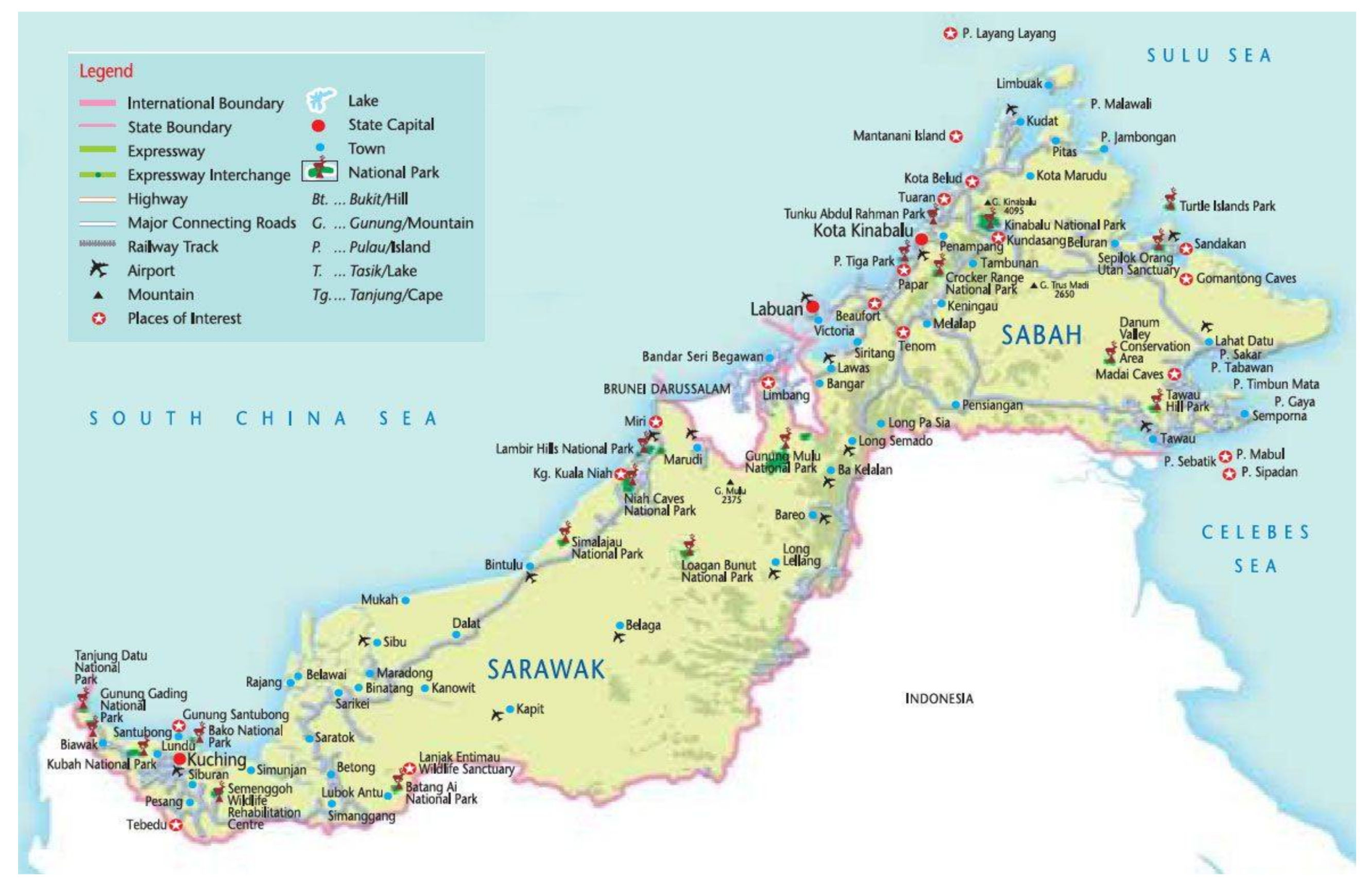
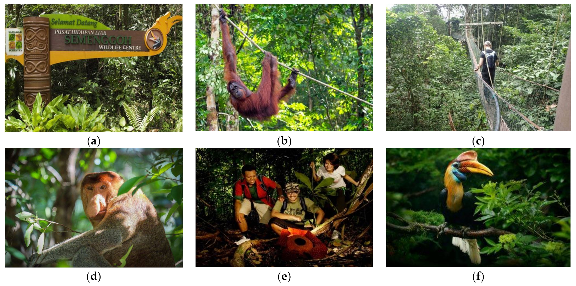
3.1. Study Area and Description

Sarawak is well known as the most committed state for nature protection in Malaysia. Sarawak’s TPAs are forest lands designated and established under the provisions of the National Parks Ordinance, 1998 and Wildlife Protection Ordinance, 1998 by the Sarawak government. It covers 8% of the state, which is about 1 million hectares, and are classified as national parks, wildlife sanctuaries, wildlife rehabilitation centres, nature reserves and marine parks (Forest Department Sarawak, 2020). People are prohibited from hunting, fishing and taking any form of forest produce in these designated TPAs. Sarawak has three types of TPAs which are (i) National Parks, (ii) Wildlife Sanctuaries and (iii) Nature Reserves as shown in Figure 1 below.
Figure 2 shows the location of eighteen (18) TPAs which covers a total area of approximately 2270 km2 (accounts for only 1.82% of the country’s entire territory). The newest addition to these TPAs is Fairy Cave nature reserve. Located near to the city of Kuching, this TPA was established in 2013. However, this TPA was closed to the public in early 2019 for site renovation. The size of national parks ranges from 0.06 km2 to 857 km2 (Table 1). Gunung Mulu national park is the largest park, covering 857.71 km2, followed by Maludam national park. At the opposite end of the scale is Wind Cave nature reserve with total area of only 0.0616 km2. It is followed by Sama Jaya nature reserve, which covers 0.379 km2 and Fairy Cave nature reserve at 0.56 km2. Figure 3a until Figure 3f shows some of the selected national parks, nature reserves and wildlife sanctuaries in Sarawak. These TPAs offer long term conservation of nature with associated ecosystem services and cultural values that indirectly attract many local and even foreign visitors to explore them. This includes endless plants and animals, including several species of primates, birds and mammals; on-site accommodation ranging from hostel beds to chalets; and daily activities including jungle trekking, wildlife spotting, night safaris and canopy walks.
The responsibility of managing these TPAs is shared mutually between Sarawak Forest Corporation (SFC) and Forest Department Sarawak. The number of visitors to Sarawak’s TPAs varies. From 2010 to 2019, the annual number of visits to TPAs slightly increased from 421,937 to 447,014. Based on descriptive statistics of visitors in 2019 (refer Table 1), the most visited park by local visitors is Sama Jaya nature reserve while by foreign visitors is Semenggoh Nature Reserve. Both of these parks are located in Kuching. In contrast, Maludam national park was the least visited park by both local and foreign visitors, with less or equal to 20 visitors for the same year. Visitors’ pressure is also highly variable. In general, Wind Cave nature reserve have the greatest pressure with visitors’ densities per km2 at 189,772.7 for locals and 67,402.60 for foreigners. Meanwhile, TPAs with least local and foreign visitors’ pressure is Maludam nature reserve with visitor densities per km2 at 0.04 and 0.01 respectively.
Table 2 explains the variables used in the study. This study used monthly data which comprised data from January 2015 to December 2019. Monthly visitors refer to the number of visitors visiting a specific park area inclusive national parks, nature reserves or wildlife sanctuaries. The data was collected from Sarawak Forestry Corporation (SFC) with approval and part of the work as stated in Memorandum of Agreement between SFC and the university.

3.2. Spatial and Temporal Analysis

In this study, a spatial and temporal analysis was used to analyse the national parks, nature reserves and wildlife sanctuaries in Sarawak. For this analysis, a temporal trend was plotted to observe the monthly visitors to the TPAs. Temporal analysis is beneficial as it provides the timeline analysis on the visitor’s concentration which affects visitor’s trend, behaviour and underlying pattern and characteristics of visitors that could potentially lead to other sources of evidence over time. The average monthly temporal analysis of visitors was plotted for the whole of Sarawak to observe the trend of visitors in Sarawak over time. The monthly temporal analysis was also plotted for each park in Sarawak to observe the trend of visitors at each area over time. In addition to this, the monthly temporal analysis on average monthly visitors were also analysed and presented to capture the monthly temporal trend behaviour. This study also produced the spatial map of average monthly visitors to describe the visitors’ concentration areas in Sarawak. Visitors’ concentration area is determined by the number of average monthly visitors. The higher the average monthly visitors would indicate the higher the visitors’ concentration. This study also produced the spatial map of average monthly visitors to indicate the visitors’ concentration areas in Sarawak. The spatial map produced in the study was analysed using spatial, map and tmap packages in R software version 3.5.2. Twelve spatial maps plotted were based on TPAs longitude and latitude coordinate were produced for each of the month (January–December) in a variation of red colour with the lightest red representing the lowest visitors’ concentration, while the darkest red represents the highest visitors’ concentration in a specific park area. The lightest red indicates a range of visitors count between 0 to 200 visitors in a particular month, while the darkest red indicates an average of between 5000 to 7000 visitors in a particular month.

3.3. Euclidean Distance

There are many types of distance measurements. Based on Johnson and Wichern [22], statistical distance can be measured by squared Euclidean distance, Minkowski metric, Canberra metric and Czekanowski coefficient. Among all of these measures, Euclidean distance is the most used distance measurement and widely used in computing distances between objects [23]. Euclidean distance measures distance of straight line between two points. The computational formula for Euclidean distance is as follows:
D a , b = a 1 b 1 2 + a 2 b 2 2
where; a and b represent the vectors, a 1 , a 2 , b 1 and b 2 represent the element of observation of vector a and b , respectively.
It can be seen that Equation (1) is equivalent to Pythagoras theorem, where if the vectors contain n dimensions, the Euclidean distance can be calculated as follows:
D a , b = a 1 b 1 2 + + a i b i 2 + a n b n 2 = i = 1 n a i b i 2
where i denotes the points of coordinates.
Thus, from Equation (2), the squared Euclidean distance can be obtained by using the following formula:
D 2 a , b = i = 1 n a i b i 2
Squared Euclidean distance is often preferred for clustering compared to other methods due to the reason that these sample quantities cannot be computed without prior knowledge of the distinct groups [22].

3.4. Ward Hierarchical Linkage Clustering

The Ward’s hierarchical algorithm is one of the agglomerative hierarchical clustering that used Euclidean distance. The aim of Wards procedure is to cluster groups where variance within is minimum and produce possible homogeneous clusters. To simplify, Ward’s method joins the two clusters whose merger leads to the smallest error sum of squares whereby at each step the pair of clusters with minimum between-cluster distance are merged [23,24]. This method is also known as Wards minimum variance method. To illustrate further, the Ward’s minimum variance method joins the two clusters A and B, which minimize the increase in the sum of squared errors (SSE).
I A B = S S E A B S S E A + S S E B
where we defined the SSE within and between cluster as follows:
S S E A = i = 1 n A a i a ¯ a i a ¯
S S E B = i = 1 n B b i b ¯ b i b ¯
S S E A B = i = 1 n A B ( y i y ¯ A B ) ( y i y ¯ A B )
where; a i is the i t h observation vector in cluster A and a ¯ is the centroid of Cluster A, b i is the i t h observation vector in cluster B and b ¯ is the centroid of Cluster B, y i is the i t h observation vector in cluster AB and y ¯ A B is the centroid of newly formed Cluster AB.
Specifically using Euclidean distance, Ward’s minimum variance method calculates the distance between cluster members and the centroid. The centroid of a cluster is defined as the point at which the sum of squared Euclidean distances between the point itself and each other point in the cluster is minimized. This can also refer to the centroids of the clusters as their mean vectors. For example, the centroid of cluster A is defined as the sum of all points in cluster A divided by the number of points in cluster A. The first cluster is formed when the smallest sum of square from the pair of sample unit is computed. The objective function of Wards clustering is to minimize variance. Thus Ward’s minimum variance method can also be written as [25]:
I A B = n A n B n A + n B a ¯ b ¯ a ¯ b ¯
where; a ¯ and b ¯ present the centroids Cluster A and Cluster B respectively. n A and n B present the size of Cluster A and Cluster B respectively.
In this study, the Ward hierarchical linkage clustering was performed using stats package in R software. The clustering method employed in this study was analyzed using hclust() function with method= “ward.D2”. The results obtained from the clustering procedure is then visualized using a dendrogram. A dendrogram is a two-dimensional graphical representation diagram used to display the results of the clustering procedure. It illustrates the information in the amalgamation table in the form of a tree diagram. The branches in the tree represent clusters. The branches come together (merge) at nodes whose positions along a distance (or similarity) axis indicate the level in which the fusions occur. Dendrogram is more useful as there are smaller numbers of cases.

4. Results

4.1. Descriptive Analysis

Typically, national parks in Sarawak are open to the public with certain entrance fee for recreation, trailing, camping, sightseeing and educational activities. On the contrary, wildlife sanctuaries have limited public access and are strictly for conservation and research both for foreign and domestic researchers. Nature reserves have the same purpose as national parks except that they are smaller in size which are less than 1000 ha (Forest Department Sarawak, 2020). According to Sarawak Forest Corporation, there were 447,014; 541,631 and 421,937 TPAs visitors in 2019, 2018 and 2015, respectively. In 2018, 142,996 were foreigners and 398,635 were domestic visitors. Generally, the number of visitors endured a decline where foreign visitors declined by 2.40%, while domestic visitors decreased by 15.00%. However, some TPAs experienced an increasing number of foreign visitors from 2018 to 2019. These TPAs were Bako National Park (0.06%), Lambir Hills (9.35%), Kubah (5.54%), Batang Ai (51.52%), Matang Wildlife Centre (10.71%), Semenggoh Nature Reserve (14.88), Logan Bunut National Park (11.90%), Tanjung Datu National Park (32.72%) and Talang Satang National Park (30.16%). TPAs that received a very high number of foreign visitors, with a more than 50% increase over a period of 5 years were Batang Ai National Park (108.33%), Gunung Gading National Park (51.97%), Kubah National Park (62.6%), Santubong National Park (87.85%), Semenggoh Nature Reserve (63.81%) and Tanjung Datu National Park (66.67%). Table 3 below shows data on the total growth of foreign visitors to the 18 TPAs.
On the other hand, most domestic visitors were inclined to visit certain TPAs. A significant increase in the number of visitors was observed comparatively from 2015, 2018 to 2019 (refer to Table 4). Over a period of one year, (2018–2019), Mulu National Park (2.77%), Lambir Hills (11.96%), Simalajau National Park (31.95%), Batang Ai (67.74%), Semenggoh Nature Reserve (0.70%), and Logan Bunut National Park (20.94%) received positive acceptance from local visitors. Meanwhile, TPAs that received very high number of local visitors for 5 years’ growth, with a more than 50% increase were Santubong National Park (92.07%) and Tanjung Datu National Park (72.01%).

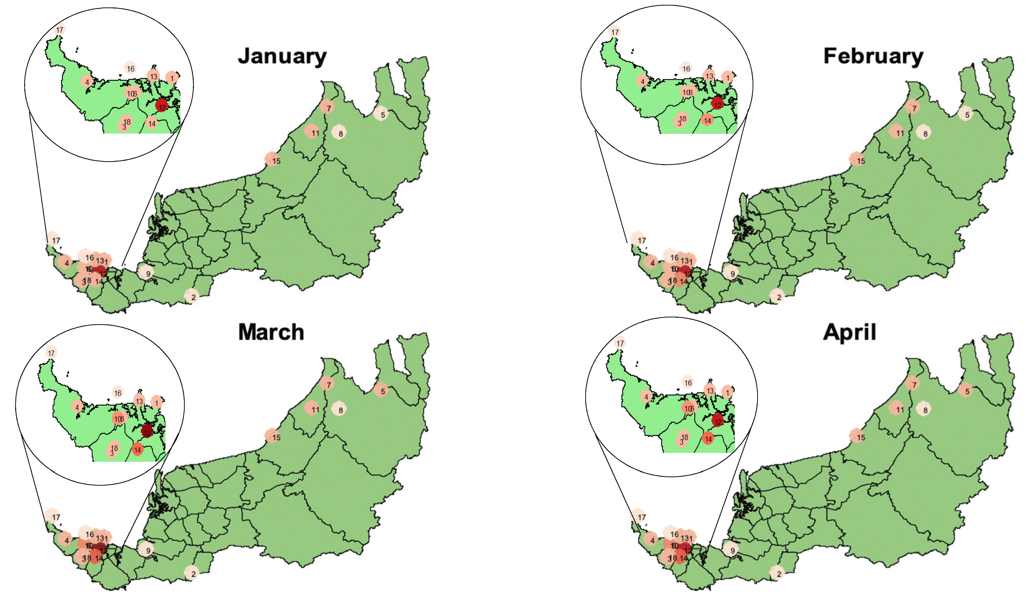
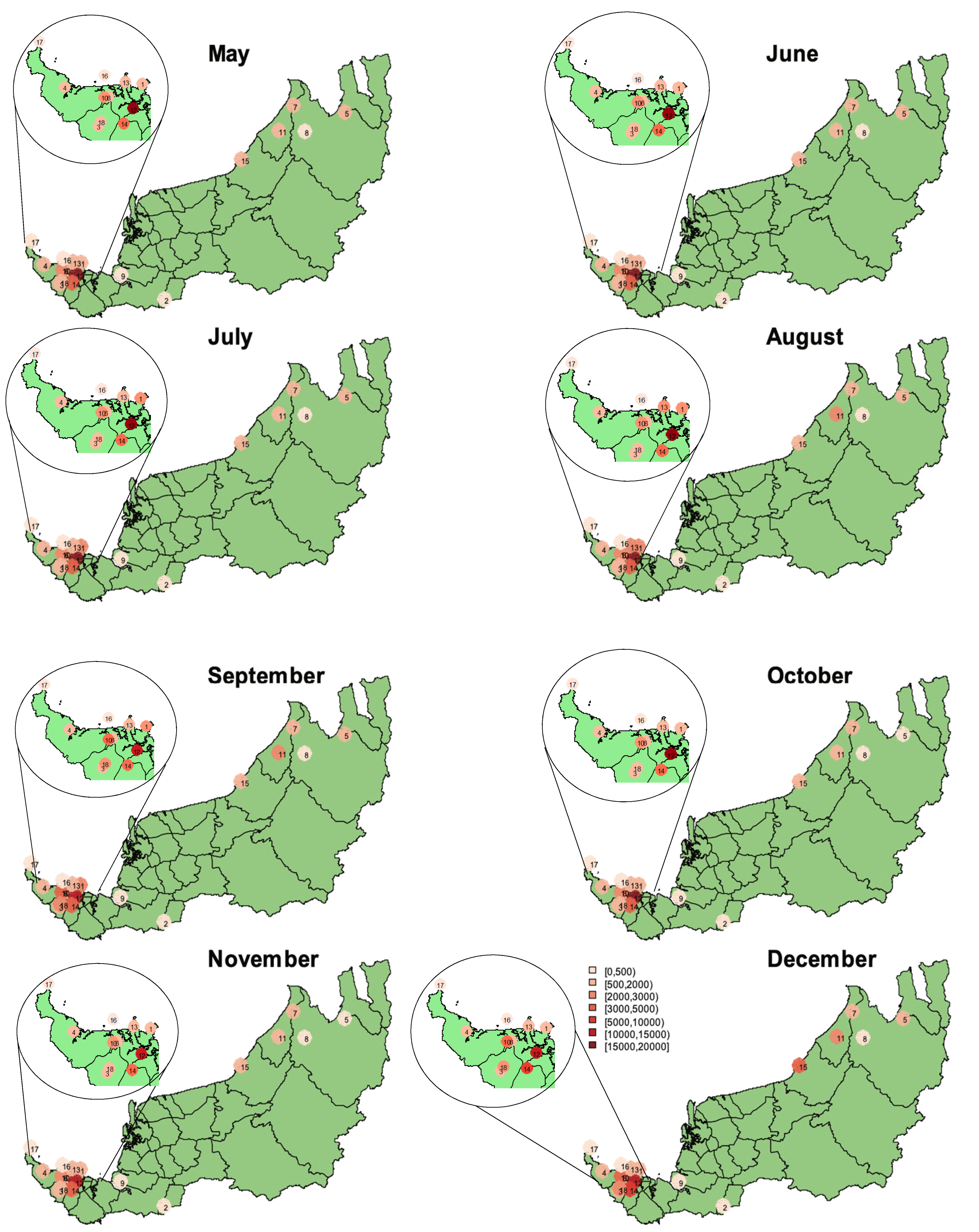
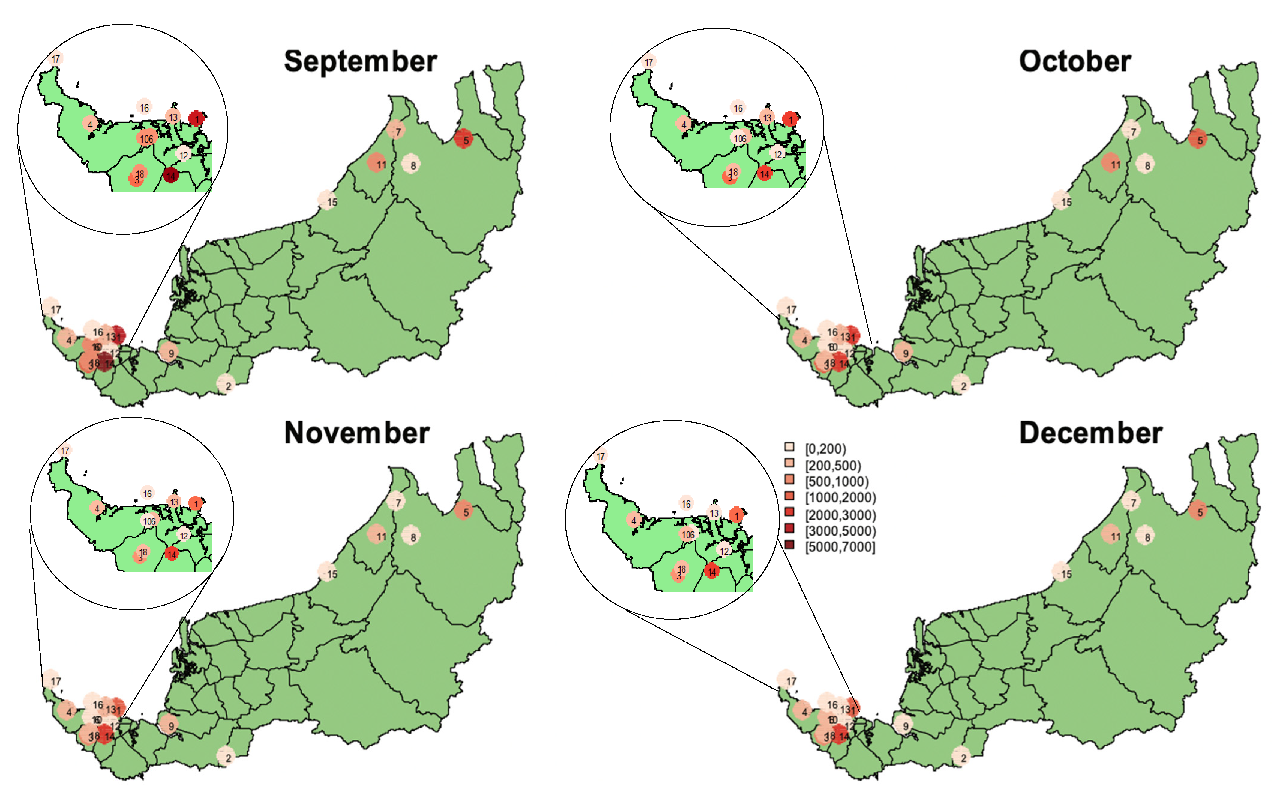
4.2. Spatial and Temporal Analysis of Local and Foreign Visitors by Park in Sarawak

This study analysed the monthly trend of visitors to investigate hidden patterns and information on the monthly trend and behaviour of visitor’s arrival in a specific park, as shown in Figure 4 and Figure 5. These findings can help local authorities to identify the visitors’ preference and trend among the chosen parks. The spatial and temporal analysis of the monthly average trend for visitors’ arrival at national parks, national reserves and wildlife sanctuaries were analyzed. The average monthly trend of local visitors’ arrival was plotted on a spatial map in Figure 4 for each park across 5 years (2015–2019). Based on the plot, it clearly showed that the trend of visitors’ arrival in Sarawak was in August, September and end of the year in the month of December. Most of the dark red points significantly appear in these months throughout the year. Throughout 2015 to 2019, school holidays and various public holidays fall in the months of August, September and December. Accordingly, trips or visits to TPAs would be planned during these months contributing to the red points on the spatial map in Figure 4 above.
The spatial maps in Figure 4 and Figure 5 show local visitors’ arrival distribution and foreign visitors’ arrival distribution, respectively, among the 18 TPAs in Sarawak. Each TPA is denoted by a code number (refer hereinafter as cn) and is given different shades of red to show visitors’ concentration. The darker the shade, the higher the visitors‘concentration. Accordingly, TPAs with high visitors’ concentration were shaded dark red, while medium red color indicates medium visitors’ concentration. For the least visitors ‘concentration, the TPAs is shaded lightest red. Analysis on the data made available determined high local visitors’ concentration were at Sama Jaya Nature Reserve (cn 12) and Semenggoh Nature Reserve (cn 14). Figure 4 shows these TPAs were shaded dark red for almost every month of the year. With a monthly average range of visitors between 10,000 to 20,000 visitors, Sama Jaya Nature Reserve and Semenggoh Nature Reserve are recognized as the flagship parks in Sarawak. These flagship TPAs were further confirmed to be the most attractive TPAs by local visitors. Sama Jaya Nature Reserve is a beautiful jungle in the city that covers approximately 38 hectares of Karangas Forest. Located just a 10 min. drive from Kuching’s city centre, this urban forest park not only provides an authentic urban wilderness but also serves as an important research centre. All its facilities and activities blend with the natural forest environment and is popular with strollers and wildlife enthusiasts. The more active visitors would appreciate the fitness trail and jogging tracks through the trees. Reputed to be amongst the most popular in Kuching, Sama Jaya’s two jogging tracks are 870 m and 1600 m, respectively. These tracks weave through striking forest scenery thus promoting a sense of oneness with nature. The park is also equipped with facilities and infrastructure to enhance social and educational activities, such as activity centre, conference room, timber and bamboo museum, forest biology museum, baruk shelter and a viewing tower. Besides housing an ethnobotanical garden with more than 80 species of plants and herbs from throughout Sarawak, a wide variety of small mammals, reptiles and amphibians could also be found in Sama Jaya Nature Reserve. This park is open daily from 7 am until 6 pm and admission is free. Semenggoh Nature Reserve is located 20 km south of Kuching. It is easily accessible and an ideal place for nature lovers. Driving to Semenggoh takes about 30 min from Kuching. Visitors can drive their own car or take a taxi from Kuching. There are also guided tours to Semenggoh provided by the local travel agents. The Reserve is open daily from 8 am to 4 pm, with admission fees ranging from RM2 to RM5 for local visitors, while for foreign visitor’s admission fees range from RM5 to RM10. Semenggoh Nature Reserve is home to a colony of semi-wild orangutans, who are trained and are used to human encounters, and it has been declared as a TPA to protect this habitat. In addition to orangutans, Semenggoh Nature Reserve is also an abode for rare flora and fauna, as well has giant squirrels, pigmy squirrels, gibbons and variety of birds. In addition to these attractions, visitors to Semenggoh Nature Reserve can also learn about the ape in the Orangutan Gallery and visit the Interpretation Area or the Botanical Research Center.
The second group of TPAs preferred by the local visitors shown by medium red colour in the spatial map were spotted in Fairy Cave (cn 3), Matang (cn 10), Gunung Gading (cn 4), Lambir (cn 7), Niah (cn 11), Similajau (cn 15), Santubong (cn 13), Kubah (cn 6), Wind Cave (cn 18) and Bako (cn 1). Among these TPAs, the majority of them are categorised as national parks. While Fairy Cave and Wind Cave are nature reserves, Matang is the only wildlife sanctuary that falls in this group of preference. These three TPAS have their own uniqueness to be offered to visitors. Fairy Cave and Wind Cave are well-known for their natural stalactites and stalagmites formed over the years, while Matang Wildlife Centre’s main attraction is the Orang Utan adoption programme.
On the other hand, the lightest red colour in the spatial plot observed every month throughout the year indicates the least visitors’ concentration by the local visitors. The least preferred TPAs by the local visitors were Loagan Bunut (cn 8), Maludam (cn 9), Batang Ai (cn 2), Gunung Mulu (cn 5), Talang Satang (cn 16) and Tanjung Datu (cn 17) with an average of less than 2000 visitors per month. These TPAs that have been identified need to be frequently and extensively monitored by the local authorities to ensure their sustainability.
Spatial and temporal analysis of monthly average trend for foreign visitor’s arrival at TPAs in Sarawak were analyzed to determine monthly trend and behaviour of foreign visitors. The monthly spatial trend of foreign visitors across 5 years (2015–2019) is shown in Figure 5. Based on the plot, it clearly showed that the trend of foreign visitors’ arrival at TPAs in Sarawak were in May, July, August and September which was in contrast with the trend for local visitors where the concentration of visitors’ arrival were mostly at the end of the year. The high concentration of foreign visitors’ arrival during these period of time was because this is the time of year where foreigners travel for their summer vacation.
Results on the spatial mapping of the foreign visitors’ concentration in Figure 5 shows a slight variation in the visitors’ arrival distribution among the TPAs compared to local visitors’ preference. The most preferred TPAs visited by foreign visitors were Bako National Park (cn 1) and Semenggoh Nature Reserve (cn 14) with the darkest red point concentrated at these TPAs in almost every month. Bako National Park and Semenggoh Nature Reserve can be recognized as the flagship parks in Sarawak for foreign visitors. They displayed high foreign visitors’ concentration of preference with an average monthly range between 5000 to 7000 visitors per month. These flagship TPAs areas were considered the most attractive TPAs with its own uniqueness. Bako National Park is the oldest national park in Sarawak. The park covers the northern tip of the Muara Tebas peninsula, an area of 27.27 square km. Bako contains almost every type of vegetation found in Borneo, as well as a rich variety of wildlife and a coastline covered with small bays, coves and beaches. Bako is also home to approximately 275 rare proboscis monkeys, found only in Borneo. An encounter with these monkeys would likely be the highlight of a visitor’s trip to Bako. To get to Bako, a visitor needs to obtain a ride from Kuching to Bako Market, which takes about 45–60 min. At the Bako Market, they then need to register, and purchase an entrance ticket and boat ticket. A 20 min. boat ride will lead to the Bako National Park Headquarters. For a local visitor, the entrance fee is RM10, while a boat ticket is RM30. For a foreign visitor, the entrance fee and boat ticket is RM20 and RM40, respectively.
Meanwhile, the second group of TPAs preferred by foreign visitors, illustrated in medium red colour in the spatial map, are Fairy Cave (cn 3), Niah (cn 11), Matang (cn 10), Wind Cave (cn 18), followed by Lambir Hills (cn 7), Sama Jaya (cn 12), Gunung Gading (cn 4), Kubah (cn 6) and Santubong (cn 13). These TPAs are located not very far from towns or cities and are easily accessible by public transport. The least concentration of visitors’ preference by foreign visitors are indicated by the lightest red colour in the spatial plot observed every month throughout the year. These TPAs were Loagan Bunut (cn 8), Maludam (cn 9), Batang Ai (cn 2), Talang Satang (cn 16) and Tanjung Datu (cn 17) with an average of less than 500 visitors per month. the least preferred TPAs areas among foreign visitors can be further monitored by the authorities for improvement and planning.
Overall, it is clearly revealed that the spatial map of monthly average local and foreign visitors to TPAs were able to supply preliminary information in determining the flagship areas of TPAs in Sarawak. The changes in visitors’ distribution in a specific area from time to time is driven by many factors including school holidays and summer break. The hot spot concentration areas of visitors that have been identified and any areas that have the tendency to be the least preferred area need to be frequently and extensively monitored by the local authorities.

4.3. Clustering Analysis of Local and Foreign Visitors of TPAS in Sarawak

Cluster analysis is utilized to group monthly local and foreign visitors to TPAs in Sarawak. The goal of cluster analysis is to find the optimal grouping variables so that all variables, TPAs with an according visitors’ number, within the same cluster are similar, while the variables, TPAs with an according visitors’ number, from different clusters differ between clusters. A Ward’s hierarchical cluster analysis with Euclidean distance was performed. The application of Ward’s Hierarchical Clustering method creates groups which reduce dissimilarity and minimize the total sums of squares within groups known as the sum of square deviations (SSD). The groups are created in such a way during each stage of the procedure that leads to the resultant solution that has the lowest SSD within groups. By considering the joints for all possible group pairs of these stages, it results into a smaller increase of clustered SSD in which all groups form a single gathered individual. Therefore, the dendrogram obtained is able to determine the flagship of TPAs local visitors’ preference in Sarawak as shown in Figure 6.
It can be concluded that all TPAs are classified into four different clusters namely Cluster 1 (very high visitors), Cluster 2 (high visitors), Cluster 3 (medium visitors) and Cluster 4 (low visitors). The first cluster is Samajaya, the flagship of the National Park, was clustered as very high visitors in Sarawak. Semenggoh was classified in the second cluster which was high visitors. While Gunung Mulu, Talang Satang, Batang Ai, Maludam, Loagan Datu were clustered in the last cluster, which implied the regions with low visitors. Affiliation of each TPA to a particular cluster is evident from Table 5.
The same finding of the cluster groups was found for foreign visitors, as shown in the dendrogram (see Figure 7). However, there is a slight difference of TPAs clustered in each group. The first cluster for foreign visitors were Bako and Semenggoh. These are the flagship of TPAs with very high foreign visitors’ preference in Sarawak. The second cluster of TPAs, namely high foreign visitors was Gunung Mulu. At 55,000 hectares, Mulu is the biggest National Park in Sarawak. It qualifies for all four of the World Heritage criteria and was declared an iconic UNESCO World Heritage Area. Meanwhile, TPAs with medium cluster visitors consisted of Similajau, Lambir Hills, Sama Jaya, Gunung Gading, Kubah, Santubong, Fairy Cave, Niah, Matang and Wind Cave. While Loagan Bunut, Batang Ai, Maludam, Talang Satang and Tanjung Datu were clustered in the last cluster, which implied TPAs with low visitors. The list of TPAs according to clusters obtained is evident in Table 6.

5. Discussion

Entry to some of the TPAs are restricted to the public. Talang Satang is a marine protected area to enhance marine turtle conservation in Sarawak. Though open for nature tourism, visits to these islands are restricted due to the sensitive nature of marine turtles and the small area of its four islands. Visitors are only allowed to visit Satang Island for day trips where land and water recreation activities are permitted in designated areas only. Tanjung Datu, the smallest national parks, is one of Sarawak’s most beautiful national parks. Previously, accessibility to Tanjung Datu was limited and received very few visitors. Nevertheless, the park is now more accessible with the opening of a new road from Sematan to Telok Melano in January 2019. To ensure the sustainability of such TPAs, the relevant agency should collaborate with universities to set up research centres. Typically, local universities are affiliated with universities abroad. This would encourage sharing of knowledge and skills, promoting new ideas and discoveries that would surely benefit future generations. This will not only generate income for the agency but assist in the agency’s works on conservation and the preservation of nature.
Communities are key to sustainable tourism development. Getting communities involved in the agency’s tourism activities bring benefits to both parties. Local communities could be employed as tour guides to visitors. Foreign visitors in particular would enjoy meeting local people and seeing what these TPAs have to offer through their eyes as a unique experience. To the local people, this is an opportunity to show visitors their neighbourhoods. In addition, local communities can usually spot overcrowding which can assist the agency to ensure the TPAs’ carrying capacity would not be compromised. They can raise warning flags before the problem becomes entrenched. Local communities can support the agency’s conservation efforts by becoming protectors of the environment. As they start to see the income generated for their community through tourism, they see the importance of protecting the fragile eco-systems and cultural treasures that tourists are coming to experience.
Generally, facilities such as accommodation, canteens, and various public amenities are available at these TPAs. Provision of these facilities could be outsourced to the local community. This will assist the relevant agency in ensuring maximum services are provided while allowing staffing flexibility. In addition, infrastructures that are lacking in some TPAs could be further developed. For example, roads for easy access to the TPAs. This is to ensure that these TPAs would not be left idle preventing illegal activities (hunting, logging, farming). Consequently, local communities would also benefit from provision of these infrastructures. Community engagement such as this would benefit the community economically and socially.

6. Conclusions

This study aimed to use spatial and temporal analysis to describe the underlying trend and temporal pattern of local and foreign visitors. The temporal distribution of visitors to 18 different TPAs are then deduced. For local visitors, the analysis showed that the trend for local visitors’ arrival in Sarawak was in August, September and end of the year in the month of December. Meanwhile, the trend for foreign visitors’ arrival in TPAs Sarawak were in May, July, August and September. In terms of visitors’ preference concentration, the study showed that TPAs with high local visitors’ preference concentration were Sama Jaya Nature Reserve and Semenggoh Nature Reserve with a monthly average range of visitors between 10,000 to 20,000 visitors. The second TPAs preferred were Fairy Cave, Matang, Gunung Gading, Lambir, Niah, Similajau, Santubong, Kubah, Wind Cave and Bako. With an average of less than 2000 visitors per month, the least preferred TPAs by the local visitors were Loagan Bunut, Maludam, Batang Ai, Gunung Mulu, Talang Satang and Tanjung Datu.
The most preferred TPAs visited by foreign visitors, with an average monthly range between 5000 to 7000 visitors per month were Bako National Park and Semenggoh Nature Reserve, where they are recognised as the flagship parks in Sarawak for foreign visitors. The second TPAs preferred by foreign visitors were Fairy Cave, Niah, Matang, Wind Cave, Lambir Hills, Sama Jaya, Gunung Gading, Kubah and Santubong. The study concluded that the least concentration of visitors’ preference by foreign visitors were Loagan Bunut, Maludam, Batang Ai, Talang Satang and Tanjung Datu with an average of less than 500 visitors per month.
The second aim of the study is to cluster the visitors according to the location of TPAs using Wards hierarchical clustering method. For local visitors, the study ascertained that Samajaya was clustered in the first cluster as very high visitors, followed by Semenggoh in the second cluster with high visitors. Meanwhile, Gunung Mulu, Talang Satang, Batang Ai, Maludam, Loagan Datu were clustered in the last cluster which implied regions with low visitors. For foreign visitors, TPAs in the first cluster with very high foreign visitors’ preference were Bako and Semenggoh. The second cluster with high foreign visitors was Gunung Mulu. Similajau, Lambir Hills, Sama Jaya, Gunung Gading, Kubah, Santubong, Fairy Cave, Niah, Matang and Wind Cave. TPAs with low visitors consisted of Loagan Bunut, Batang Ai, Maludam, Talang Satang and Tanjung Datu. These findings give an insight into tourists’ arrival in Sarawak and uncovers hidden patterns of each TPAs, which can be used for strategic decision making in planning and monitoring tourism in TPAs.

Author Contributions

Conceptualization, A.Z.A.A. and S.A.M.N.; Data curation, S.A.M.N. and W.F.W.Y.; Formal analysis, S.A.M.N. and W.F.W.Y.; Funding acquisition, A.Z.A.A. and S.J.; Methodology, W.F.W.Y.; Resources, S.M.; Visualization, A.Z.A.A., S.A.M.N. and W.F.W.Y.; Writing—original draft, S.A.M.N., W.F.W.Y. and S.J.; Writing—review & editing, A.Z.A.A. and S.J. All authors have read and agreed to the published version of the manuscript.

Funding

The authors would like to thank Sarawak Forestry Corporation for the funding of this research (SFC.100-3/1/52-ECO (1)).

Data Availability Statement

Not applicable.

Acknowledgments

Authors would like to thank reviewers for their helpful and constructive comments and suggestions that greatly contributed to improving the final version of this paper.

Conflicts of Interest

The authors declare no conflict of interest.

References

  1. De Urioste-Stone, S.M.; Scaccia, M.D.; Howe-Poteet, D. Exploring visitor perceptions of the influence of climate change on tourism at Acadia National Park, Maine. J. Outdoor Recreat. Tour. 2015, 11, 34–43. [Google Scholar] [CrossRef]
  2. Rodríguez-Piñeros, S.; Mayett-Moreno, Y. Forest owners’ perceptions of ecotourism: Integrating community values and forest conservation. Ambio 2015, 44, 99–109. [Google Scholar] [CrossRef] [PubMed] [Green Version]
  3. Jaafar, M.; Kayat, K.; Tangit, T.M.; Yacob, M.F. Nature-based rural tourism and its economic benefits: A case study of Kinabalu National Park. Worldw. Hosp. Tour. Themes 2013, 5, 342–352. [Google Scholar] [CrossRef]
  4. de Castro, E.V.; Souza, T.B.; Thapa, B. Determinants of tourism attractiveness in the national parks of Brazil. Parks 2015, 21, 51–62. [Google Scholar]
  5. Stemberk, J. Factors Affecting the Number of Visitors in National Parks in the Czech Republic, Germany and Austria. Int. J. Geo-Inf. 2018, 7, 124. [Google Scholar] [CrossRef] [Green Version]
  6. Forest Department Sarawak. Totally Protected Area (TPAS). Available online: https://forestry.sarawak.gov.my/modules/web/pages.php?mod=webpage&sub=page&id=661# (accessed on 4 May 2020).
  7. Department of Statistic Malaysia. Regional Tourism Satellite Account Sarawak. Available online: https://www.dosm.gov.my/v1/index.php?r=column/pdfPrev&id=Qlc3cW5WRkE5cEtKYStkaUs1UzNJdz09 (accessed on 10 December 2019).
  8. Dzhandzhugazova, E.A. New forms and possibilities for promotion of Russian national parks in the internet environment. Middle-East J. Sci. Res. 2013, 16, 1238–1244. [Google Scholar] [CrossRef]
  9. Duzgunes, E.; Demirel, O. Importance of Visitor Management in National Park Planning. J. Environ. Prot. Ecol. 2016, 17, 675–680. [Google Scholar]
  10. Lacher, R.G.; Brownlee, M.T. Determinates of clustering across America’s national parks: An application of the Gini coefficients. In Fisher, Cherie LeBlanc; Watts, C.E., Jr., Ed.; Department of Agriculture, Forest Service, Northern Research Station: Newtown Square, PA, USA, 2012; pp. 183–188. [Google Scholar]
  11. Fanelli, R.M.; Romagnoli, L. Customer satisfaction with farmhouse facilities and its implications for the promotion of agritourism resources in Italian municipalities. Sustainability 2020, 12, 1749. [Google Scholar] [CrossRef] [Green Version]
  12. Botha, E.; Saayman, M.; Kruger, M. Clustering Kruger National Park visitors based on interpretation. S. Afr. J. Bus. Manag. 2016, 47, 75–88. [Google Scholar] [CrossRef]
  13. D’Urso, P.; De Giovanni, L.; Disegna, M.; Massari, R.; Vitale, V. A Tourist Segmentation Based on Motivation, Satisfaction and Prior Knowledge with a Socio-Economic Profiling: A Clustering Approach with Mixed Information. Soc. Indic. Res. 2021, 154, 335–360. [Google Scholar] [CrossRef]
  14. Dolnicar, S. A review of data-driven market segmentation in tourism. J. Travel Tour. Mark. 2002, 12, 1–22. [Google Scholar] [CrossRef]
  15. Prayag, G.; Disegna, M.; Cohen, S.A.; Yan, H. Segmenting markets by bagged clustering: Young Chinese travelers to Western Europe. J. Travel Res. 2015, 54, 234–250. [Google Scholar] [CrossRef] [Green Version]
  16. Ernst, D.; Dolnicar, S. How to avoid random market segmentation solutions. J. Travel Res. 2018, 57, 69–82. [Google Scholar] [CrossRef] [Green Version]
  17. Barić, D.; Anić, P.; Bedoya, A. Segmenting protected area visitors by activities: A case study in Paklenica National Park, Croatia. Eur. J. Tour. Res. 2016, 13, 103–121. [Google Scholar]
  18. Stylidis, D. Residents’ place image: A cluster analysis and its links to place attachment and support for tourism. J. Sustain. Tour. 2018, 26, 1007–1026. [Google Scholar] [CrossRef]
  19. Veisten, K.; Grue, B.; Haukeland, J.V.; Degnes-Ødemark, H.; Baardsen, S. Tourist segments for new facilities in an alpine national park area: Profiling tourists in Norway based on psychographics and demographics. In Proceedings of the 5th Symposium for Research in Protected Areas, Osttirol, Austria, 10–12 June 2013; pp. 773–782. [Google Scholar]
  20. Roman, M.; Roman, M.; Prus, P.; Szczepanek, M. Tourism Competitiveness of Rural Areas: Evidence from a Region in Poland. Agriculture 2020, 10, 569. [Google Scholar]
  21. Roman, M.; Roman, M.; Niedziółka, A. Spatial Diversity of Tourism in the Countries of the European Union. Sustainability 2020, 12, 2713. [Google Scholar]
  22. Johnson, R.A.; Wichern, D.W. Applied Multivariate Statistical Analysis, 6th ed.; Pearson New International Edition: Upper Saddle River, NJ, USA, 2014. [Google Scholar]
  23. Murtagh, F.; Legendre, P. Ward’s hierarchical agglomerative clustering method: Which algorithms implement Ward’s criterion? J. Classif. 2014, 31, 274–295. [Google Scholar] [CrossRef] [Green Version]
  24. Lattin, J.; Carroll, J.D.; Green, P.E. Analyzing Multivariate Data; Thomson Learning. Inc.: Toronto, ON, Canada, 2003. [Google Scholar]
  25. Strauss, T.; von Maltitz, M.J. Generalising Ward’s method for use with Manhattan distances. PLoS ONE 2017, 12, e0168288. [Google Scholar] [CrossRef] [Green Version]
Figure 1. Map of Sarawak. (source: https://www.adventurealternative.com/travel-in-borneo/, accessed on 16 September 2021) (2018).
Sustainability 13 11618 g001
Figure 2. Location of national parks, nature reserves and wildlife sanctuaries in Sarawak.
Sustainability 13 11618 g002
Figure 3. Selected national parks, nature reserves and wildlife sanctuaries in Sarawak. (a) source: kuchingborneo.info (2018); (b) source: viator.com (2019); (c) source: tripadvisor.com.my (2017); (d) source: wanderlust.co.uk (2013); (e) source: tripsavvy.com (2020); (f) source: birdlife.org (2019).
Sustainability 13 11618 g003
Figure 4. Spatial and temporal map for average monthly local visitors to national parks, nature reserves and wildlife sanctuaries in Sarawak.
Sustainability 13 11618 g004aSustainability 13 11618 g004b
Figure 5. Spatial and temporal map for average monthly foreign visitors to national parks, nature reserves and wildlife sanctuaries in Sarawak.
Sustainability 13 11618 g005aSustainability 13 11618 g005b
Figure 6. Dendrogram of local visitors to TPAs in Sarawak.
Sustainability 13 11618 g006
Figure 7. Dendrogram of Foreign Visitors to National Parks, Nature Reserves and Wildlife Sanctuaries in Sarawak.
Sustainability 13 11618 g007
Table 1. Characteristics of national parks, nature reserves and wildlife sanctuaries.
NoTotally Protected Area (TPAS)Size (km2)Distance (km) to Nearest CityYear of GazettedLocal Visitors 2019Local Visitors/km2Foreign Visitors 2019Foreign Visitors/km2Latitude
‘N
Longitude
‘E
1.Bako National Park27.2723.2195719,941731.2440,4061481.701.7167110.4667
2.Batang Ai National Park240.4054.01991310.13500.211.1472111.8743
3.Fairy Cave Nature Reserve0.5642.32013----1.3818110.1172
4.Gunung Gading National Park54.3085.219839755179.65416476.691.6906109.8458
5.Gunung Mulu National Park857.71106.0197459766.9715,04617.544.0921114.8958
6..Kubah National Park22.3023.3198910,833485.785143230.631.6128110.1969
7.Lambir Hills National Park69.4932.3197510,479150.80267938.554.1984114.0429
8.Loagan Bunut National Park107.36117.019914624.30470.443.7775114.2272
9.Maludam National Park535.6848.002000200.0480.011.5271111.1414
10.Matang Wildlife Centre1.8033.2199725,46314,146.1149092727.221.6094110.1602
11.Niah National Park31.3890.0197519,319615.655188165.333.8014113.7841
12.Sama Jaya Nature Reserve0.3798.42000118,434312,490.7721765741.421.5197110.3890
13.Santubong National Park16.4135.3200715,508945.033789230.901.7333110.3333
14.Semenggoh Nature Reserve6.5322.0200046,3057091.1249,6917609.651.4017110.3145
15.Similajau National Park89.9628.8197812,376137.57114112.683.3483113.1564
16.Talang Satang National Park194.1433.61999870.456693.451.7843110.1643
17.Tanjung Datu National Park13.79140.0199492266.8679557.652.0554109.6422
18.Wind Cave Nature Reserve0.061637.6199911,690189,772.73415267,402.6043.6046103.4213
Table 2. List of Variables.
VariablesMeasurement UnitVariables
Name of the ParkNameName of the Park
Number of visitorsCountNumber of visitors
Latitude°NLatitude
Longitude°ELongitude
Table 3. Total Growth of Foreign Visitors.
NoNational Park 12015 12018 12019 11 Year Growth (%)
(2018–2019)
5 Years Growth (%) (2015–2019)
1.Bako National Park28,21140,38240,4060.0643.23
2.Batang Ai National Park24335051.52108.33
3.Fairy Cave Nature Reserves50817118Under renovation--
4.Gunung Gading National Park208234913164−9.3751.97
5.Gunung Mulu National Park12,84315,85015,046−5.0717.15
6.Kubah National Park3163487351435.5462.60
7.Lambir Hills National Park3401245026799.35−21.23
8.Loagan Bunut National Park51424711.90−7.84
9.Maludam National Park62830033.33
10.Matang Wildlife Centre36904434490910.7133.04
11.Niah National Park518962105188−16.46−0.02
12.Sama Jaya Nature Reserves394124922176−12.68−44.79
13.Santubong National Park201738283789−1.0287.85
14.Semenggoh Nature Reserve30,33543,25549,69114.8863.81
15.Similajau National Park267618231141−37.41−57.36
16.Talang Satang National Park96351466930.16−30.53
17.Tanjung Datu National Park47759979532.7266.67
18.Wind Cave Nature Reserves376151504152−19.3810.40
Total107,911142,996139,053
1 Forest Department Sarawak, 2019.
Table 4. Total Growth of Local Visitors.
NoNational Park 12015 12018 12019 11 Year Growth (%) (2018–2019)5 Years Growth (%) (2015–2019)
1.Bako National Park17,89622,96419,941−13.1611.43
2.Batang Ai National Park50103167.74−38.00
3.Fairy Cave Nature Reserves20,14617,729---
4.Gunung Gading National Park16,18515,7079755−37.89−39.73
5.Gunung Mulu National Park5780581559762.773.39
6..Kubah National Park11,72714,01110,833−22.68−7.62
7.Lambir Hills National Park12,902936010,47911.96−18.78
8.Loagan Bunut National Park104838246220.94−55.92
9.Maludam National Park-5020−60.00-
10.Matang Wildlife Centre33,16232,43825,463−21.50−23.22
11.Niah National Park21,86620,22619,319−4.48−11.65
12.Sama Jaya Nature Reserves169,756162,747118,434−27.23−30.23
13.Santubong National Park807422,21615,508−30.1992.07
14.Semenggoh Nature Reserve46,30445,98346,3050.700.00
15.Similajau National Park23,509965212,73631.95−45.83
16.Talang Satang National Park26618987−53.97−67.29
17.Tanjung Datu National Park536963922−4.2672.01
18.Wind Cave Nature Reserves23,91118,19311,690−35.74−51.11
Total413,118398,635307,961
1 Forest Department Sarawak, 2019.
Table 5. List of TPAS Clusters Form for Local Visitors.
Very High VisitorsHigh VisitorsMedium VisitorsLow Visitors
Sama JayaSemenggohMatang
Bako
Niah
Similajau
Fairy Cave
Santubong
Wind Cave
Kubah
Gunung Gading
Lambir Hills
Gunung Mulu
Talang Satang
Batang Ai
Maludam
Loagan Bunut
Tanjung Datu
Table 6. List of TPAs Clusters Form for Foreign Visitors.
Very High VisitorsHigh VisitorsMedium VisitorsLeast Visitors
Bako
Semenggoh
Gunung MuluSimilajau
Lambir Hills
Sama Jaya
Gunung Gading
Kubah
Santubong
Fairy Cave
Niah
Matang
Wind Cave
Loagan Bunut
Batang Ai
Maludam
Talang Satang
Tanjung Datu
Publisher’s Note: MDPI stays neutral with regard to jurisdictional claims in published maps and institutional affiliations.

