1. Introduction
The faulted Yunnan Basin is a major rocky desertified area in China formed by violent unbalanced crustal movements during the Tertiary period [
1,
2]. The annual erosion modulus of soil can reach 98,100 t/km
2·a, which is much higher than the average 500 t/km
2·a for much of China [
3,
4]. These unique geographical conditions lead to a simple community structure that is vulnerable to degradation under human disturbance, which in turn leads to excessive population growth and economic poverty [
5]. The population density of most karst counties in Yunnan Province is much higher than in other provinces, generally 120–250 people/km
2 [
6]. By 2017, there were 2.79 million poor people in Yunnan, accounting for 9.1% of China’s poorest population. These areas often consist of undeveloped barren hillsides suitable for fruit cultivation. In addition, fruit trees provide ecological functions, including soil and water conservation, which can help promote the development of ecological tourism, leisure tourism, and other industries [
7,
8].
Given these opportunities, China’s central and local governments issued a series of documents to support the development of fruit farming and eliminate rural poverty; these include “some opinions on giving priority to the development of agriculture and rural areas and doing a good job in the work of agriculture, rural areas, and farmers” and the “targeted poverty alleviation plan of Yunnan Province’s Characteristic Industries” (
http://www.gov.cn;
http://www.yn.gov.cn/, accessed on 30 September 2020). Between 2008 and 2018, the annual average fruit planting area and output of Yunnan displayed rapid and stable growth at 7.6% and 9.9%, respectively (
http://data.stats.gov.cn, accessed on 30 September 2020), with “one main producing area and four sub-areas” becoming the main production area along with Honghe Prefecture [
9]. The per capita net income of rural residents in karst areas also increased by 79.9%, which was higher than the national mean of 54.4% for the same period [
10].
Numerous studies have been conducted on the overall impacts of industrial poverty alleviation and various ecological projects (e.g., afforestation and grass planting; forest and grassland protection) [
11,
12,
13]. However, those efforts focused mainly on long-term trends or macro-scale processes using remote sensing images and models, while less attention has been paid to specific modes of planting at the town scale [
12,
13,
14,
15]. Furthermore, existing studies have demonstrated that different varieties of fruit have different economic and ecological values [
16,
17,
18], which makes it possible to improve the total output of regional ecosystem services through the coordinated cultivation of multiple varieties of fruit. However, to the best of our knowledge, there have not been many studies on this. To address this knowledge gap, this study used scenario-based simulation and a geographical information system (GIS) framework to explore changes in ecosystem service delivery associated with the development of fruit planting in Yunnan Province, and the transformational effects of different production modes at the county scale. In doing so, we explored the impacts of the coordinated planting of fruit varieties on regional-scale economic and ecological benefits.
2. Materials and Methods
2.1. Research Area and Fruit Production Modes
Honghe Hani and Yi Autonomous Prefecture, Yunnan Province, China, is a typical faulted karst basin where 17.58% of the population (587,000 people) live below the poverty line and 45.04% (2345.08 km
2) of the country is undergoing desertification [
19]. In the last 20 years, the fruit-growing industry has begun to develop in this area with the support of government poverty alleviation policies and the implementation of a three-phase desertification control project.
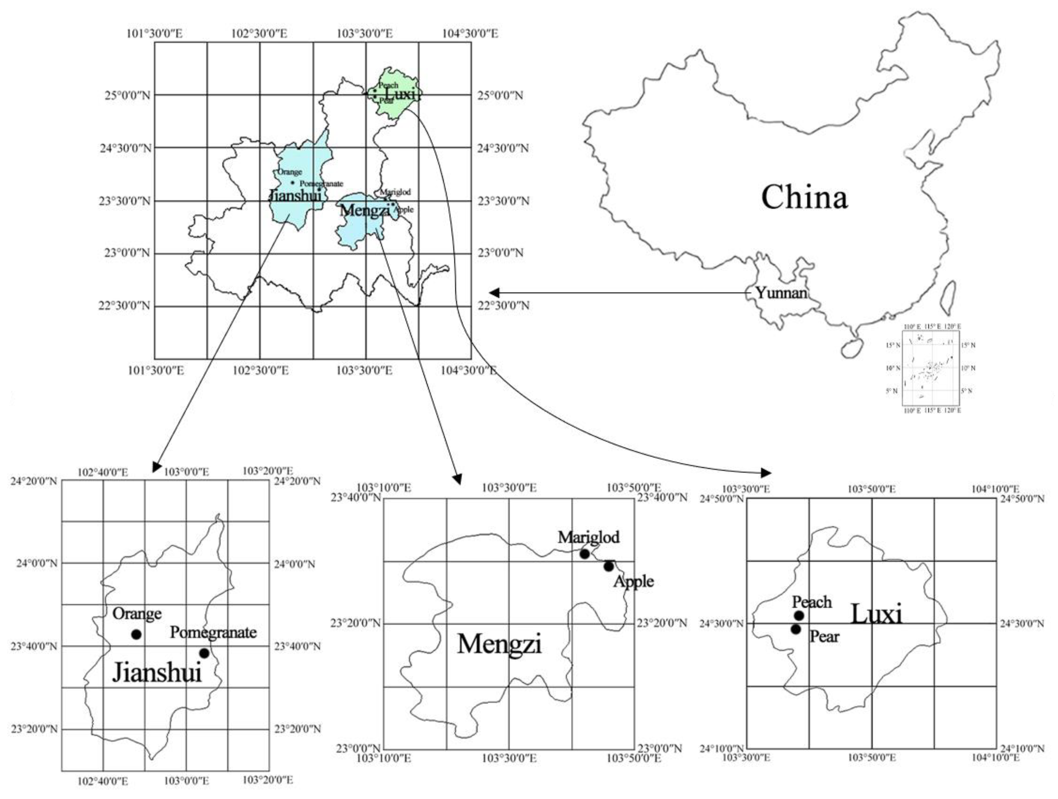
This study focused on three typical demonstration areas subject to desertification in Honghe Hani and Yi Autonomous Prefecture: Jianshui County, Luxi County, and Mengzi City (
Figure 1). Based on the Statistical Yearbook (2015–2018) and a 2016 preliminary field survey, two typical planting modes were selected for each site (
Table A2). Orange and pomegranate cultivation were selected for Jianshui County, which has an elevation ranging from 230–2515 m, average annual temperature of 19.4 °C, average annual rainfall of 1045.5 mm, and an annual average of 2047.9 h of sunshine. Pear and peach cultivation were selected for Luxi County, which has an elevation ranging from 820–2459 m, average annual temperature of 16.0 °C, average annual rainfall of 1028.1 mm, and an annual average of 1951.1 h of sunshine. Finally, apple and marigold cultivation were selected for Mengzi City, which has an elevation ranging from 397–2494 m, average annual temperature of 19.0 °C, annual average rainfall of 1377.1 mm, and an annual average of 2228.3 h of sunshine (
Table A1). To obtain the data required, a face-to-face questionnaire survey was conducted with farmers from July‒September in 2017 and 2018, and field samples were collected in 2017 and tested in 2018 [
20].
2.2. Geospatial Data
Slope data was calculated from a 30 m × 30 m resolution digital elevation model (DEM) obtained from the Geoscientific Data Cloud website (
http://www.gscloud.cn, accessed on 30 September 2020). Land-use data for 2015, at the same resolution, were derived from Landsat-8 images [
21]. Monthly temperature and rainfall data were obtained from the National Meteorological Data Center and interpolated from 2012–2016 records.
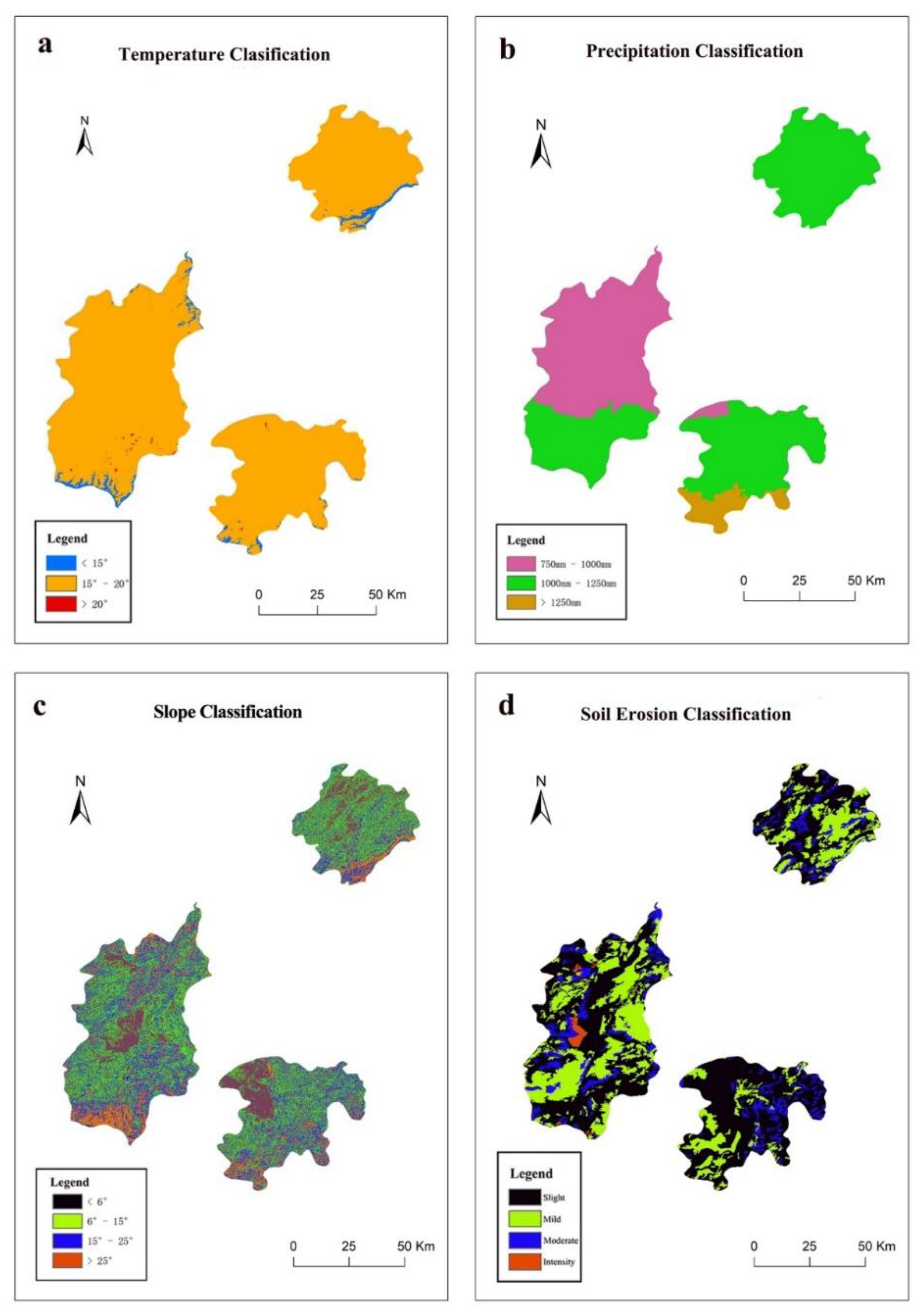
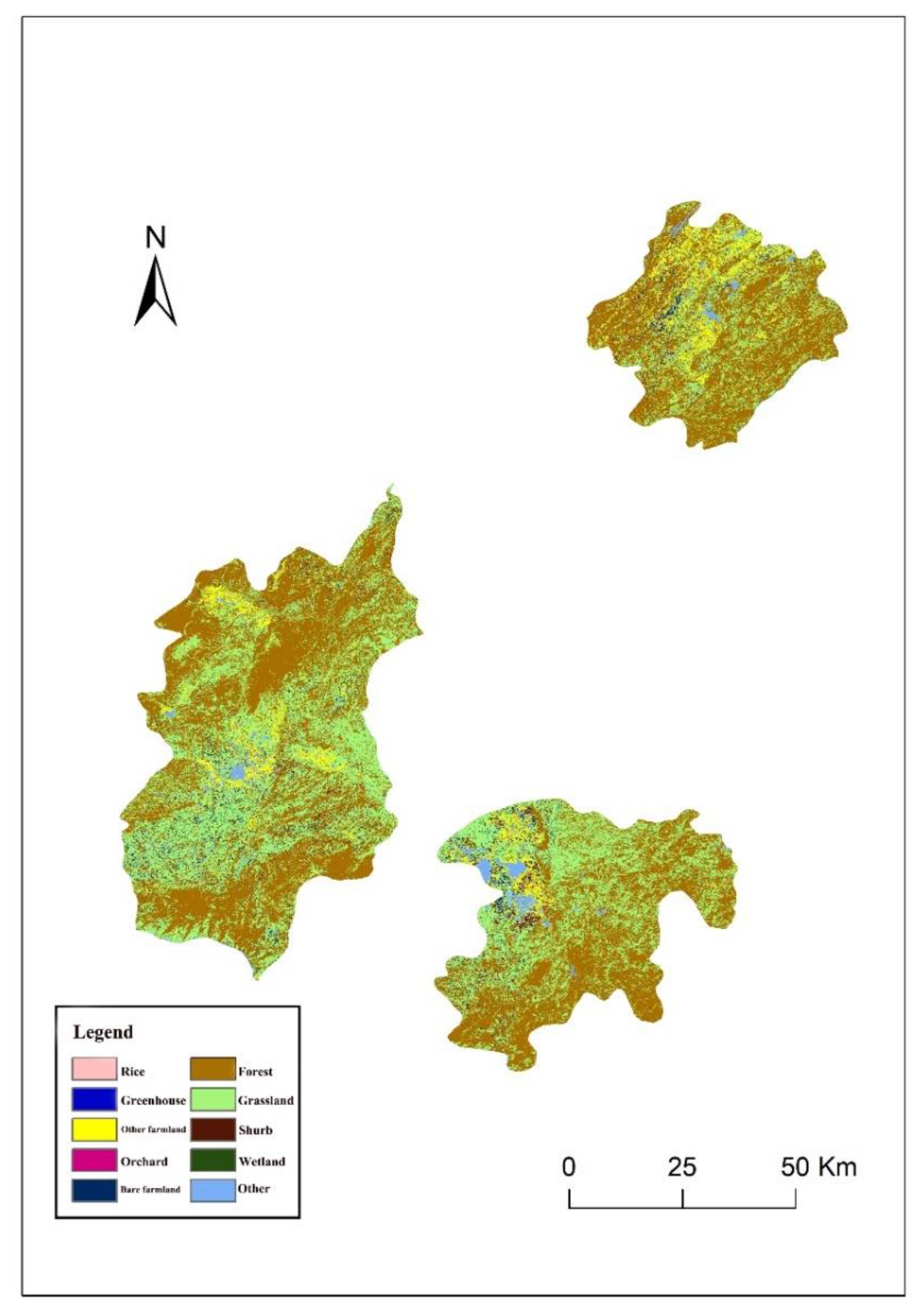
To evaluate the maximum area suitable for planting in each mode, climatic and geographical factors were classified, as follows. The “Technical Regulations for Investigation of Land Use Status” and “Technical Regulations for Determining the Gradation of Cultivated Land Using DEM (for trial implementation)” guidelines were used to divide slope gradients into the following four grades: <6°, 6–15°, 15–25°, and >25°. The growth characteristics of the modes of cultivation studied were used to divide the annual average rainfall into the following categories: <750 mm, 750–1000 mm, 1000–1250 mm, and >1250 mm. The annual average temperature was divided into the following categories: <15 °C, 15–20 °C, and >20 °C. We aimed to focus on the economic and ecological benefits brought about by changes in planting modes; hence, land-use data were reclassified into eight categories including rice fields, other farmland, bare farmland, and forests. All GIS layers were generated as 30 m × 30 m raster images.
2.3. Ecosystem Service Data
Previous studies have found that climate factors and altitude can significantly change the ripening time of fruits planted in Yunnan, but have little effect on other characteristics [
22]. Therefore, we used pattern-based ecosystem service data from previous studies to represent the entire study area (
Table A4). Briefly, we categorized the provision of fruits and flowers into the following ecosystem services as per the Millennium Ecosystem Assessment framework and evaluation criteria for karst regions: general provisioning services, reducing topsoil loss, maintaining soil fertility, and photosynthetic carbon fixation as a regulating service, photosynthetic oxygen release and nutrient retention as supporting services, and education as a cultural service [
20] (
Table A3 and
Table A4). In general, pomegranate cultivation should be prioritized where economic benefits are sought and apple cultivation should be promoted where ecological benefits are needed.
To eliminate the impact of the differences in the composition of and calculation methods for different ecosystem services, relative ecosystem services were calculated based on the following formulas.
In Equation (1), Relative ES is the value of one specific type of ecosystem service (ES) after standardization, ESi represents the actual total amount of ecosystem service i (e.g., maintaining soil fertility) in one quadrat, ESi−max is the maximum value of the actual total amount of ecosystem service i in all land-use patterns quadrats, and ESi−min denotes the minimum value under the same condition.
To equalize the weights of the contributions of the four types of ecosystem services to total ecosystem services (TES), the latter was calculated using Equation (2). The modified index eliminated the impact of differences in the number of types of service in each category.
In Equation (2), Relative ESp is the standardized value of provisioning services.
2.4. Scenario Setting
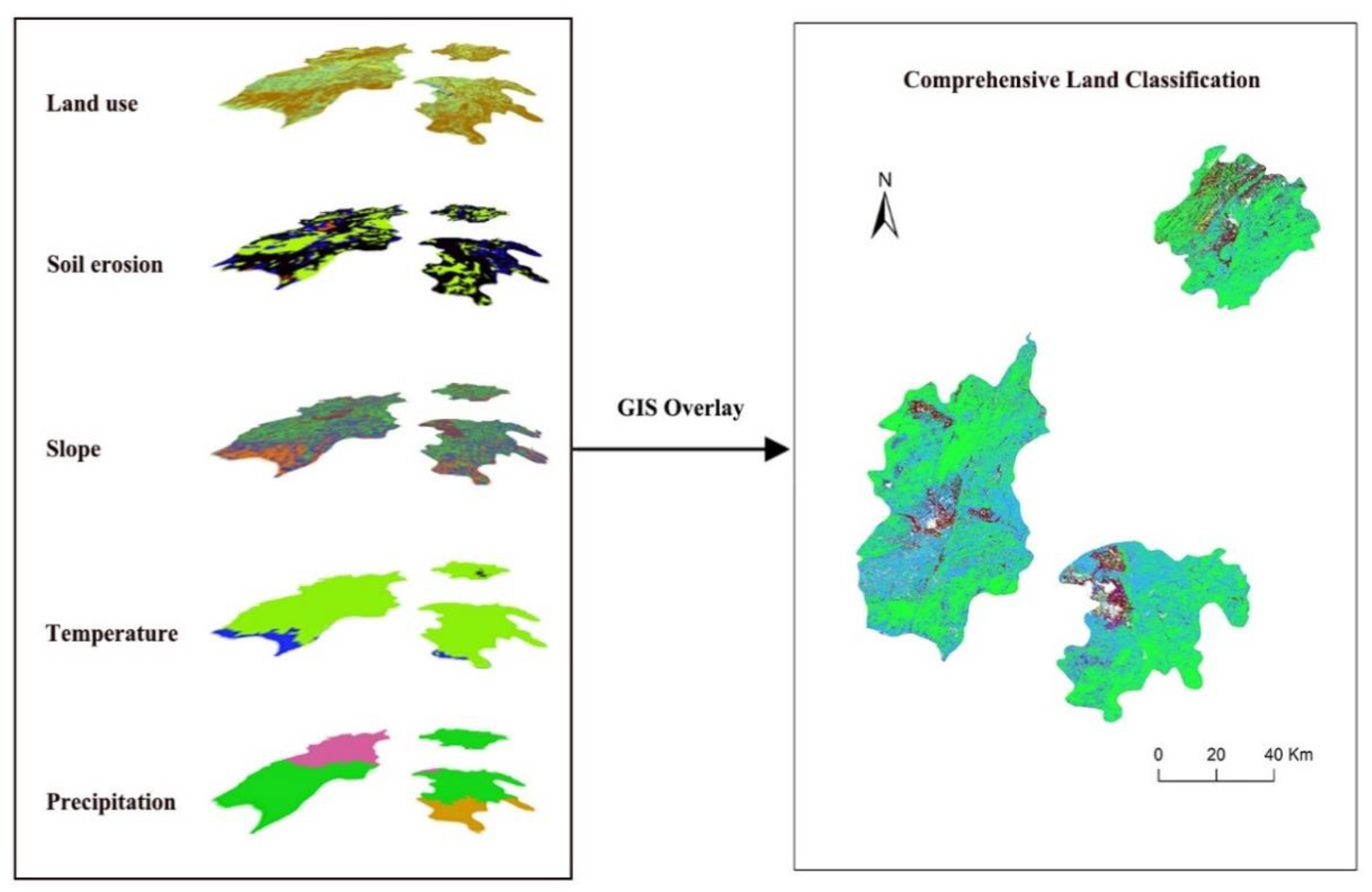
Planting area data for each planting mode in 2016, 2017, and 2018 were obtained from the three county governments. The planting areas for each mode in 2023 were used as the baseline scenario (i.e., the result of development according to current trends). In the ecological priority scenario, the planting mode with the greatest ecological benefits is promoted preferentially; in the economic priority scenario, the planting mode with the greatest economic benefits is promoted. A land classification map of the three counties was obtained at the same time to help identify areas suitable for planting and those at high risk of degradation; this was done by superposing topography, soil erosion, land-use, and climate datasets (
Figure 2,
Table A5,
Table A6 and
Table A7). The scenario analysis was conducted based on the transformation of farmland into various planting modes, as per the relevant national land-use policies and regulations (e.g., Law of the People’s Republic of China on Land Administration; Forest Law of the People’s Republic of China), and is summarized in
Table 1.
To better measure the changes in ecosystem services resulting from land-use changes, the equal-area change rate (EACR) was calculated based on Equation (3) as follows:
4. Discussion
The complex relationships between land-use and ecosystem services make it difficult for stakeholders to obtain and interpret key information on ecosystem service provision in different future land-use planning contexts [
23]. Many studies have noted that land-use largely determines the transformation of regional ecosystem services, while the increase or decrease of ecosystem services will simultaneously cause changes in land-use modes [
24,
25]. In reality, the mutual transformation of different land-use modes is often accompanied by the expansion of specific land-use types. Unlike previous studies that have focused on multi-category land-use types (e.g., grassland, forests, and farming areas) [
26,
27], we focused on the rapid spread of planting in rural areas aimed at generating high economic benefits.
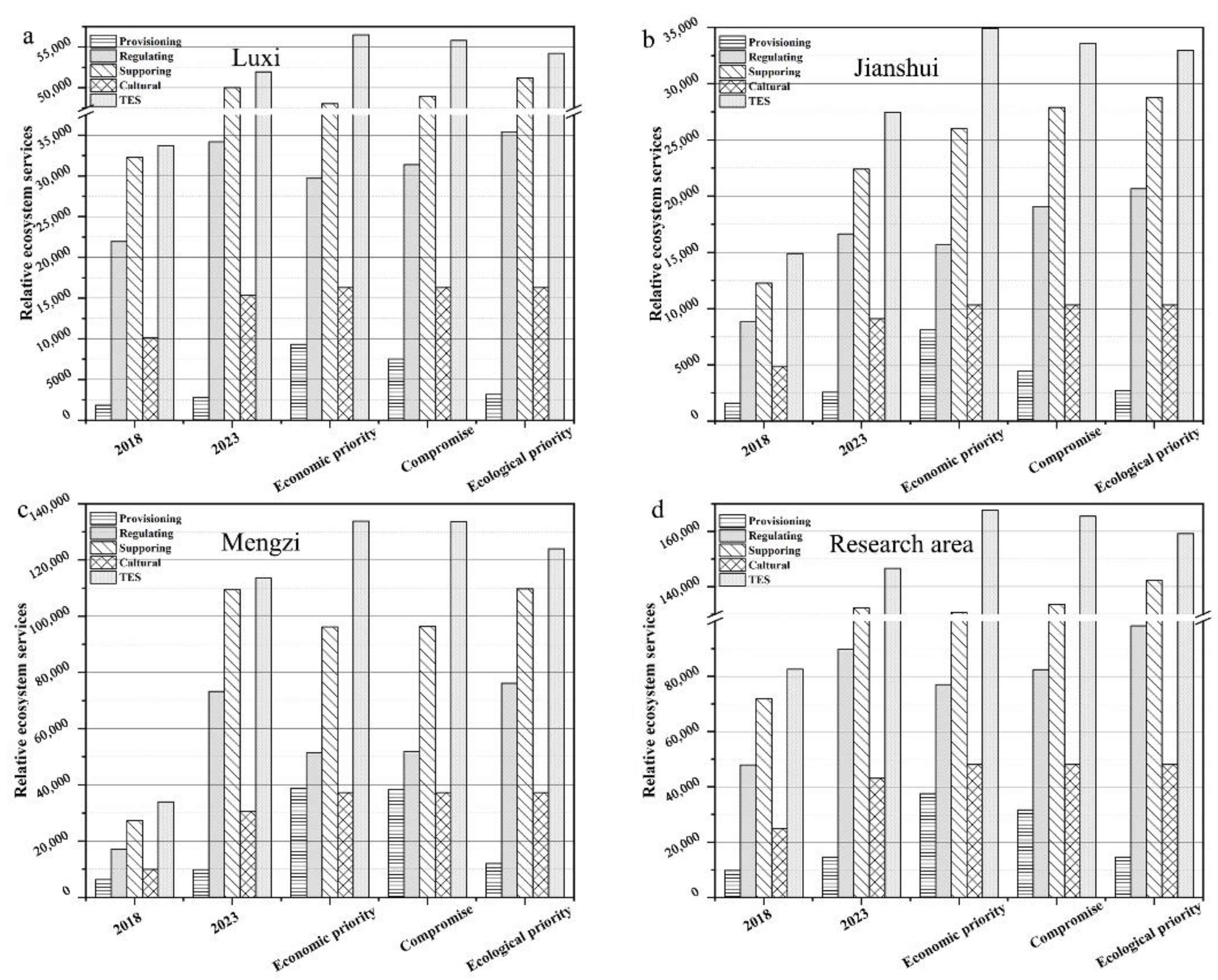
Our results demonstrate that, based on current planting trends in Luxi County, Jianshui County, and Mengzi City, areas of fruit cultivation and associated profits will increase in all cases, in line with national policy on poverty alleviation and desertification control. However, this hindered the study of regional changes in ecosystem service provision caused by land-use changes. The expansion in the planting area meant that total ecosystem service provisions for Luxi County, Jianshui County, and Mengzi City were projected to increase significantly; however, accounting for the increase in the growing area, a 3% decline is projected for Jianshui County and Mengzi City (
Table 5). For example, all types of services are expected to decline in Jianshui County, while provisioning services in Mengzi City could decrease by as much as 28%, contrary to expectations. Across the entire study area, TES provision will increase by 78% by 2023, based on current development trends, indicating that complementary and diverse land-use modes can limit ongoing decline; in other words, there are tradeoffs in spatial ecosystem services [
28]. In addition, fine-scale land-use management interventions can be used to maximize ecosystem service gains [
29].
In our forecasts, the economic priority scenario met expectations to provide the largest increase in provisioning services while also achieving the highest overall TES. In contrast, provisioning services declined in Jianshui County and Mengzi City under the ecological priority scenario. Furthermore, provisioning services increased by 17% under the ecological priority scenario in Luxi County, where there was an overall increase of 11% in all services; this was 4% lower than in the economic priority scenario. Declines in supporting, regulating, and cultural services in Luxi County are dampened, consistent with two key conclusions in previous research. The first of these was that there are tradeoffs between provisioning services and other types of services [
20,
30]. The second is that a reasonable spatial arrangement of land uses can ease these tradeoffs, and that outcomes can be improved by employing sophisticated land management methods at smaller scales, depending on the context [
31,
32].
According to the ecological priority scenario, the provision of supporting services increased by 50% across the entire research area; this is consistent with current trends. Ecosystem disservices (e.g., fertilizer, water, and pesticide consumption) can also change simultaneously with adjustments in the variety of crops planted [
33,
34]. Our results indicate that irrigation costs will increase to CNY 9.13 million in 2023 and CNY 14.46 million under the economic priority scenario (
Table A9 and
Table A10). On the contrary, the costs of irrigation, pesticides, and water consumption are >10% lower under the ecological priority scenario than under current trends. In addition, the portion of land planted with apple trees will be greatly increased, which will assist in the preservation of soil nutrients (
Table A8). This demonstrates that the current development pattern is not considered optimal. Overall, the planting trend for development in Jianshui County should be adjusted, as the compromise scenario offers an effective method of reversing the current declines in ecosystem service provision while also stimulating growth. Luxi County and Mengzi City should plan development according to the compromise scenario; however, the provision of regulation services needs to be further improved in these areas.
The inability to collect sufficient information to build accurate fruit-planting maps, due to a lack of satellite data and local-scale species-specific information, was a major limitation of our study [
35,
36]. It is difficult to accurately evaluate long-term trends in ecosystem service provision in the fruit planting industry, as it is highly market dependent. Many external factors (e.g., changes in varieties and international market influences) affect the provisioning services associated with fruit cultivation, whereas regulation services and supporting services (including carbon fixation and oxygen release) are comparatively stable [
37]. Equally, however, the ecosystem services and disservices provided by orchards that are longstanding elements of a landscape will interact with the surrounding landscape. Our study measured this only in terms of crop water requirements and irrigation cost to reflect water consumption by orchards; however, this does not consider the water exchange with the surrounding area [
38]. Therefore, improved long-term statistics are needed for specific fruit varieties to more accurately predict their benefits. In addition, fruit trees—a crucial element in alleviating poverty among fruit growers—play a non-substitutable role in leisure agriculture and will provide farmers with more benefits via their ornamental value. For example, a flowering time spanning February‒May and a picking period from July‒October can be created by planting pear, cherry, and pomegranate orchards in adjacent areas; this would support a six-month “golden tourist season” [
39]. However, tourism values are also affected by multiple interacting factors, making the benefits of developing specific fruit-farming practices difficult to determine.


