Article

Application of the Coastal Hazard Wheel for Coastal Multi-Hazard Assessment and Management in the Guang-Dong-Hongkong-Macao Greater Bay Area

College of Electronics and Information Engineering, Guangdong Ocean University, Zhanjiang 524088, China
*
Authors to whom correspondence should be addressed.
Sustainability 2021, 13(22), 12623; https://doi.org/10.3390/su132212623
Submission received: 25 September 2021 / Revised: 3 November 2021 / Accepted: 12 November 2021 / Published: 15 November 2021
(This article belongs to the Special Issue Environmental Hazards: Assessing Risk and Reducing Disaster)

Abstract

:
The coasts of Guangdong-Hong Kong-Macao Greater Bay Area (GBA) are facing threats and challenges from rising sea levels, frequent extreme events and human intervention. In this study, the Coastal Hazard Wheel (CHW) was used to classify the coasts of GBA, assess its hazard change from 2010 to 2020, identify hazards hotspots and explore available coastal management options. The results show that the coastal types of GBA in 2010 and 2020 are consistent, with delta/low estuary island and hard rock slope as the main types. GBA is vulnerable to ecosystem disruption, saltwater intrusion, gradual inundation and flooding hazards. Compared with 2010, the high risk proportion of each hazard in 2020 decreased significantly, but the high risk of flooding increased slightly. All kinds of hazards are interdependent and influenced by each other. The Pearl River Estuary, the east bank of Yamen Waterway, the west bank of Huangmao Sea and Dapeng Bay show very high hazard vulnerability, and the flooding risk is the highest. Soft measures such as coastal zoning, tsunami warning systems, wetland restoration and hazard simulation are most widely used in coastal management. CHW is applicable to GBA’s coastal hazard vulnerability assessment, which provides a case study for coastal risk assessment of GBA and has certain reference significance for hazard management and sustainable development for the Bay Area.

1. Introduction

The coastal zone is an active zone where the ocean and the continent interact with each other. Due to its superior geographical position, it has become the most active and concentrated area of human activities. With the global environmental change and the further agglomeration of population and related resources, coastal zones are faced with increasing risks such as storm surge, flood, delta subsidence and geological hazards [1], and the vulnerability of coastal zones is becoming increasingly prominent [2]. It is mainly manifested in coastal erosion, frequent marine hazards and destruction of ecosystem, which will pose a great threat to coastal geology, ecological security and socio-economic development [3,4]. The Guangdong-Hong Kong-Macao Greater Bay Area (GBA) is one of the most open and economically dynamic regions in China. It undertakes the important mission of building a world-class Bay Area and urban agglomeration. It is located in the key zone of land and sea interaction, which is ecologically fragile, prone to many hazards and most sensitive to global environmental changes [5,6]. The ecosystem is faced with structural fragmentation, function degradation, value decline and other problems, which threaten the resource, environment and ecological security, and restrict the sustainable development of GBA. Therefore, it is of great significance for smart management and sustainable development of coastal zones to study the vulnerability of coastal zones under multiple driving factors and assess the degree of vulnerability by adopting appropriate risk management or vulnerability assessment methods.
Vulnerability is the state of susceptibility to harm from exposure to stresses associated with environmental and social change and from the absence of capacity to adapt [7]. According to different research objects, vulnerability studies can be divided into three categories: natural ecosystem, socio-economic system and nature-socio-economic coupling system [8]. Studies on coastal zone vulnerability generally start from the two aspects of climate change and human activities and evaluate various natural coastal or production factors. There are various conceptual frameworks for vulnerability assessment, such as Driving Force-State-Response (DSR), Driving Force-Pressure-State-Impact-Response (DPSIR), Driving Force-pressure-state-exposure-effect-action (DPSEEA) and source-pathway-receptor-consequence (SPRC) [2]. Research subjects include different spatial scales, with more attention paid to the regionality and particularity of vulnerability issues [3,9], for example, the River Delta has become one of the most environmentally fragile regions, showing strong vulnerability in the process of responding to natural environmental changes on land and sea, human activities and their interactions. India and the United States have produced the most research on coastal vulnerability [10]. At present, there are mainly five methods used for coastal hazard assessment at home and abroad. They are Coastal Erosion Risk Assessment (CERA) [11], Coastal Vulnerability Index (CVI) [12], Smartline [13], Coastal Hazard Wheel (CHW) [14] and the RISC-KIT Coastal Hazard Assessment Module (CHAM) [15]. Narra et al. [16] studied the characteristics and applicability of various methods. Among them, CVI is one of the most commonly used methods in the world, which combines a variety of natural and socio-economic variables, and calculates vulnerability index through certain classification and combination [10,17]. Chinese researchers mainly conducted coastal vulnerability assessment on the environmental and socio-economic impacts of future sea level rise on River Deltas [18]. For example, Xiao [19], Liu and Shen [20], Liu et al. [21] assessed the vulnerability of the Yellow River Delta, Yangtze River Delta and Pearl River Delta (PRD) in China by using CVI method, combing physical indicators such as geological layout, soil, vegetation, coastline and tidal range. Socio-economic factors were used in some studies, with population as the most commonly used indicator [10]. In general, the research on coastal zone vulnerability assessment is changing from qualitative description to quantitative assessment, from static assessment to spatiotemporal dynamic simulation study, and from a single natural index system to a comprehensive natural and socio-economic index system, which is the inevitable trend of current and future development [4].
At present, discussions and studies on GBA mostly focus on social economy, policy and other aspects [22,23], there are few studies on coastal vulnerability, and more attention is paid to sub-vulnerability such as geological hazards and environmental pollution, which have not been considered as a whole, and no systematic studies have been formed [24]. The study of vulnerability distribution mainly uses multivariate and mathematical methods, while hazard research mainly focuses on the impact of floods and typhoons and carries out quantitative risk assessment and measures exploration of related hazards [19,25,26,27,28]. Comprehensive hazard prevention planning for the coastal zone of GBA needs to be improved, and research on natural hazard prevention, hazard management and response strategy is still weak. Therefore, there is an urgent need to solve the problems of coastal hazards at regional scale and seek an effective path for the comprehensive protection and utilization planning, hazard prevention, safety and sustainable development of the coastal zone in GBA [29,30].
The main objective of this paper is to use CHW to analyze the coastal vulnerability of GBA and study the process of its coastal hazard change from 2010 to 2020. CHW is a globally oriented coastal classification and decision support system proposed by Appelquist et al. [31], which can be used to assess multiple hazards (e.g., ecosystem disruption, gradual inundation, salt-water intrusion, erosion and flooding) from local to national coasts and develop related management programs to assist integrated coastal zone management (ICZM) to better respond to the impacts of climate change. At present, CHW has been applied in coastal hazard assessment studies in foreign regions, such as India, Colombia, Djibouti and Malta, which is mainly used to assess the impact of coastal erosion hazards [14,32,33,34,35,36,37].

2. Materials and Methods
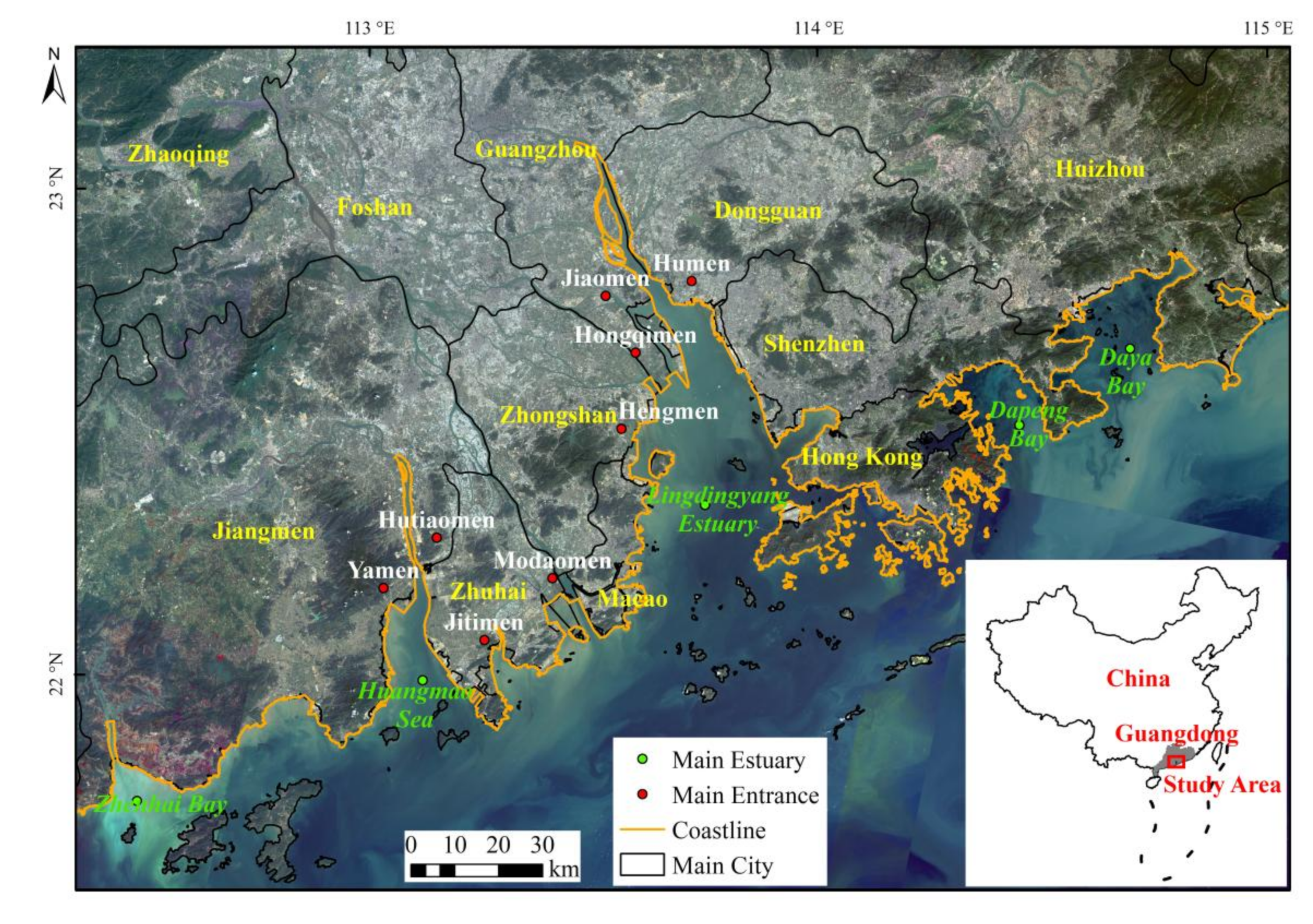
2.1. Study Area

Located between 21.57° N–24.39° N and 111.36° E–115.41° E, GBA is located in the coastal center of Guangdong Province, bounded by Huizhou city in the east and the junction of Taishan and Yangjiang River at the mouth of Zhenhai Bay in the west. Consisting of nine cities (Guangzhou, Shenzhen, Zhuhai, Foshan, Zhongshan, Dongguan, Huizhou, Jiangmen, Zhaoqing), Hong Kong and Macao in PRD, the area, population and GDP of the region are about 14%, 39% and 68% of that of Guangdong Province, respectively, making it one of the bay areas with the highest population and economic density in the world [38]. The curved coast of the Bay Area is prominent, and the coast is mostly covered by bedrock and buildings. The types of coastlines are complex and diverse, with a generally southeast-facing concave arc. The Bay Area can be divided into sections according to Zhenhai Bay, Huangmao Sea, Lingdingyang Estuary, Dapeng Bay and Daya Bay (Figure 1). Since China’s reform and opening up, the population in GBA has increased year by year, the demand for land and urban construction has become more intense, and the contradiction of more people and less land has come to the fore, driving the development of industry and economy, causing a boom in reclamation activities and dramatic changes in coastline, which is greatly affected by human activities [39,40].
Located in the southern margin of the South China fold belt, GBA has a long geological history and has experienced many tectonic movements, forming marine accumulation and marine erosion landforms. The NE, NW and EW trending tectonic lines are formed. Under the influence of these lines, many fault block structures are formed along the coast and headlands, and bays are interchanged [29]. The landforms on land and underwater are complex, including mountains, hills, terraces, plains amongst other forms. The terrain is mainly plain, accounting for about 70%, and the others are mostly mountains and hills. Zonal soils are mainly lateritic and red soil, developed on sandstone, shale and granite parent material [41]. Bound by PRD, GBA is a composite delta accumulated in the estuary by the sediment brought by the lower reaches of the Xijiang, Beijiang and Dongjiang rivers of the Pearl River system. The tidal flat is rich in resources and emptied into the South China Sea from the east to the west by eight entrances, such as Humen, Jiaomen and Hongqimen. Facing the vast South China Sea, the tide is irregular mixed semidiurnal tide, and the perennial average tidal range is less than 2 m. GBA has a subtropical and tropical monsoon climate, with high temperature and rainy weather all year round. The average annual temperature is 21–23 ℃, and the average annual sunshine hours exceed 2000 h. Most of the rainfall is concentrated in summer and autumn, with an annual rainfall of more than 1500 mm, and frequent rainstorms in summer, often resulting in flooding hazards. Northeasterly wind predominates in autumn and winter, southeast and southwest wind predominates from late spring to summer [26]. Typhoons often have the influence of strong winds, floods and storm surges all year round, which cause heavy casualties and economic losses. In 2020, the coastal sea level of Guangdong Province will fluctuate greatly, which will aggravate the occurrence of storm surge, flooding and other hazards [19].

2.2. Data and Method

This paper uses CHW 3.0 to evaluate the coastal vulnerability of GBA. The CHW has been recommended by the United Nations Environment Programme (UNEP) as a hazard assessment tool to aid coastal managers, planners and policy makers assess how coastal areas are likely to be affected in relation to different hazard levels induced by climate change [14]. This tool was mostly designed to enhance decision-making in developing states [32], which does not require a large amount of data and can achieve an intermediate accuracy level.

2.2.1. Data Collection and Processing

The CHW framework is based on a specially designed coastal classification system that contains the main geo-biophysical parameters (geological layout, wave exposure, tidal range, vegetation, sediment balance and storm climate) that determine the characteristics of coastal systems and aims to cover all coastal areas worldwide. It uses the coastal geological layout as a basis on which it adds the main dynamic parameters and processes acting in the coastal environment. Based on the development characteristics of GBA and data availability, the process of change from 2010 to 2020 is analyzed. The data, data sources and classification criteria for 2010 and 2020 are shown in Table 1.
Collect the 30 m resolution DEM data (GDEM V2), the coastal zone landform type map (1:1,600,000) of GBA and the global estuary dataset [42] and extract the coastline of GBA in 2010 and 2020 from Google Earth images [43] to classify the geological layout (see Table 1 row 2–6). In ArcGIS 10.6, use “Slope” tool to process DEM data and get slope distribution map. If it is muddy, biological, gravel or farmland aquaculture coastline, it can be divided into “Sedimentary plain” or “Slop soft rock” according to the slope. If it is bedrock, port wharf or other artificial coastline, it can be divided into “Flat hard rock” or “Sloping hard rock”.
Collect hourly significant wave height of GBA with a horizontal resolution of 0.5°× 0.5°, it can be divided into three types (Table 1 row 7–9). In addition, collect the daily data of the highest and lowest tide levels at 21 tide gauge stations in the Pearl River Estuary (PRE), subtract and average to obtain the tidal range. In ArcGIS 10.6, use the Kriging interpolation method to obtain the tidal range distribution map of GBA, and divide it into three types (Table 1 row 10–12). According to the 30 m horizontal resolution land cover dataset [44] and mangrove distribution dataset [45], divide the region into vegetated, not vegetated, marshes and mangroves (Table 1 row 13–16).
Based on coastline changes from 1980 to 2020, CHW divides sediment balance into three main classes: sediment deficit, balance and surplus (Table 1 row 17–18). Use the coastline dataset of GBA from Su et al. [43] to determine the direction of change. Since Google Earth images are taken at different times during the tidal cycle, coastlines are likely to deviate from the actual Mean Sea Level, but this is considered of minor importance for the purpose of this assessment, as it only requires relatively accurate and up-to-date coastlines, with an accuracy of less than 10 m. The coastline in 1980 is used as the baseline and the coastline in 2010 or 2020 is used as the line of change to determine whether the state of coast is balance, deficit or surplus. Areas of gravel coastlines fall into a separate category. In addition, collect tropical cyclone activity data to determine the extent of impact based on historical cyclone activity trajectories (Table 1 row 19).

2.2.2. Application of the Coastal Hazard Wheel

The CHW framework is provided as a graphical tool to facilitate its application for planning purposes. CHW 3.0 is represented by a disk and consists of six indicators: geological layout, wave exposure, tidal range, vegetation, sediment balance and storm climate. Starting from the center of the disk, each index was classified sequentially, which could be divided into 131 coastal environments and scenarios. Then, according to the divided coastal types, the vulnerability of ecosystem disruption, gradual inundation, salt water intrusion, erosion and flooding hazard in the corresponding region was assessed, and each hazard was divided into four levels: low, moderate, high and very high (Figure 2).
The coastal classification and hazard assessment procedure is carried out in ArcGIS based on high-resolution image from Google earth. First, create a geodatabase in ArcGIS 10.6 that will contain all coastal classification data and hazard class data, then import and process the data described in 2.2.1. Then, segment the coastline layers for 2010 and 2020 according to the coastline type and used as the main layer, while the length of each line segment should be controlled within 200 m to apply the CHW method and achieve a detailed division of coastal types. Then, create multiple new fields in the attribute table of the main layer to represent the indicator information, and enter the classification results such as slope, wave height and tidal range into the fields of the corresponding segments. In addition, check Figure 2 to determine the coastal type and hazard level of five hazards for each line segment, and add them to the attribute table fields. Finally, make coastal classification map and five types of hazard map through visualization, aiming to show a comprehensive picture of hazard hotspots and hazard distribution along the coast of GBA. View the manual [31] to explore available measures for various hazards according to coastal types.

3. Results

3.1. Characterisation of the GBA

The coastal characteristics of GBA were evaluated in terms of six indicators: geological layout, wave exposure, tidal range, vegetation, sediment balance and cyclone activity. During 2010–2020, the coastal zone of GBA was strongly influenced by human activities with significant changes in coastline type, coastline location and land cover type, as well as differences in the movement trajectories of cyclone activities, but lithology, slope, wave height and tidal range did not change significantly on short time scales (10 years). The main input layers of GBA to CHW in 2020 are shown in Figure 3.

3.1.1. Geological Layout

The study area is located in the river mouth delta area, whose coastal zone landforms are plains, hills and mountains and the coastline types are mostly bedrock coastline and artificial coastline. After considering elevation and coastal types, geological layout can be divided into sediment plains (PL), delta/low estuary island (DE), flat hard rock (FR), slop soft rock (SR) and sloping hard rock (R), and the geological layout types have changed during 2010–2020. R is mainly located in the west bank of Hong Kong and Daya Bay, accounting for 30.64% and 30.43% in 2010 and 2020, respectively. DE is located in Lingdingyang Estuary, Huangmao Sea and Dapeng Bay, accounting for 42.75% and 43.86% in 2010 and 2020, respectively. These are the main geological types in GBA (Figure 3a).

3.1.2. Wave Exposure

Located near the estuary, GBA is less affected by the wave and circulation of the South China Sea, and the wave height is below 3 m. Most of the area falls into the protected category, with only parts of Hong Kong showing moderate exposure.

3.1.3. Tidal Range

The tidal type of GBA is complex, and the size of tidal range increases from the open ocean to the inland. The eastern region is the low tidal range area, and the outlet of PRE is the high tidal range center, and the tidal range is greater than 2 m, which is meso tidal. All other areas are micro tidal (Figure 3b).

3.1.4. Floral Characteristics

The coastal zone of GBA has an obvious monsoon climate, abundant rainfall and diverse vegetation types. It can be divided into four types: vegetation cover, bare, marsh and mangrove, among which vegetation cover and mangrove are more widely distributed. Mangroves are mainly distributed at the junction of Shenzhen and Hong Kong and the Yamen area of Huangmao Sea, with an increase in the mangrove area in 2020.

3.1.5. Sediment Balance

Since the 1980’s, the Bay Area’s coastline has been largely silted up as a result of the region’s economic development, and the overall state is in balance, which is manifested as seaward siltation. Among them, the siltation amount from 1980 to 2020 is greater than that from 1980 to 2010, that is, the coastal siltation of the GBA is obvious from 2010 to 2020. Sediments in the Pearl River, Yamen Waterway, Hong Kong and Shenzhen areas facing the open ocean are in balance state (Figure 3c).

3.1.6. Storm Climate

Influenced by topography, circulation and human activities, GBA is often affected by typhoons all the year round. Tropical cyclone activity was recorded in Nansha area of PRE, west of Dapeng Bay, west of Huangmao Sea and Guanghai Bay.

3.2. Coastal Classification

According to six indicators, CHW divides GBA into multiple coastal types (Table 2, Figure 4). The results show that the GBA coast types in 2010 and 2020 are consistent, with DE, R, FR, PL and SR types in descending order of the proportion of each type to the total shoreline length, with DE and R as the main types. DE type is distributed in Lingdingyang Estuary, Huangmao Sea and Dapeng Bay, while R type is mainly distributed in Hong Kong.
DE types are the most diverse. In DE system, DE-13 and DE-16 accounted for the highest proportion and were the most important types, which were characterized by wave protection, micro tidal and mangrove-dominated characteristics. During 1980–2020, the coastline of DE-13 showed erosion or balance and tropical cyclone activity (13.61% and 12.58%), which was mainly distributed in Dapeng Bay. The coastline of DE-16 was characterized by deposit and no tropical cyclone activity record (10.38% and 15.10%), which was mainly distributed on the banks of Lingdingyang Estuary and Huangmao Sea. In addition, DE-21 showed meso tide and tropical cyclone activity, accounting for 6.87% and 5.43% of the total coastline. DE coast can also be divided into DE-11, DE-12, DE-14, DE-17 and DE-24, among which DE-15, DE-21 and DE-23 are the common coastal types in 2010 and 2020, mainly distributed in PRE. According to the two characteristics of micro tidal and no cyclone activity, R is classified into R-1 type, accounting for 30.64% and 30.43% of the total coastline length respectively, and mainly distributed in prominent open estuaries, such as Hong Kong and Daya Bay. FR is mainly distributed in Daya Bay, accounting for 17.56% and 17.71%, respectively. FR-18 is the main type, and no vegetation cover is the difference with other types. FR-19 and FR-20 are marsh or mangrove areas. PL are mainly distributed in Zhenhai Bay and are characterized by moderate wave exposure. SR accounted for a small proportion (1.88% and 1.57%) and distributed sporadically.
From Table 2, there is no significant change in coastal categories and proportions from 2010 to 2020, and the coastal sub-categories in 2020 are more detailed, mainly reflected in DE and PL types. Accordingly, the risks of various coastal hazards will change.

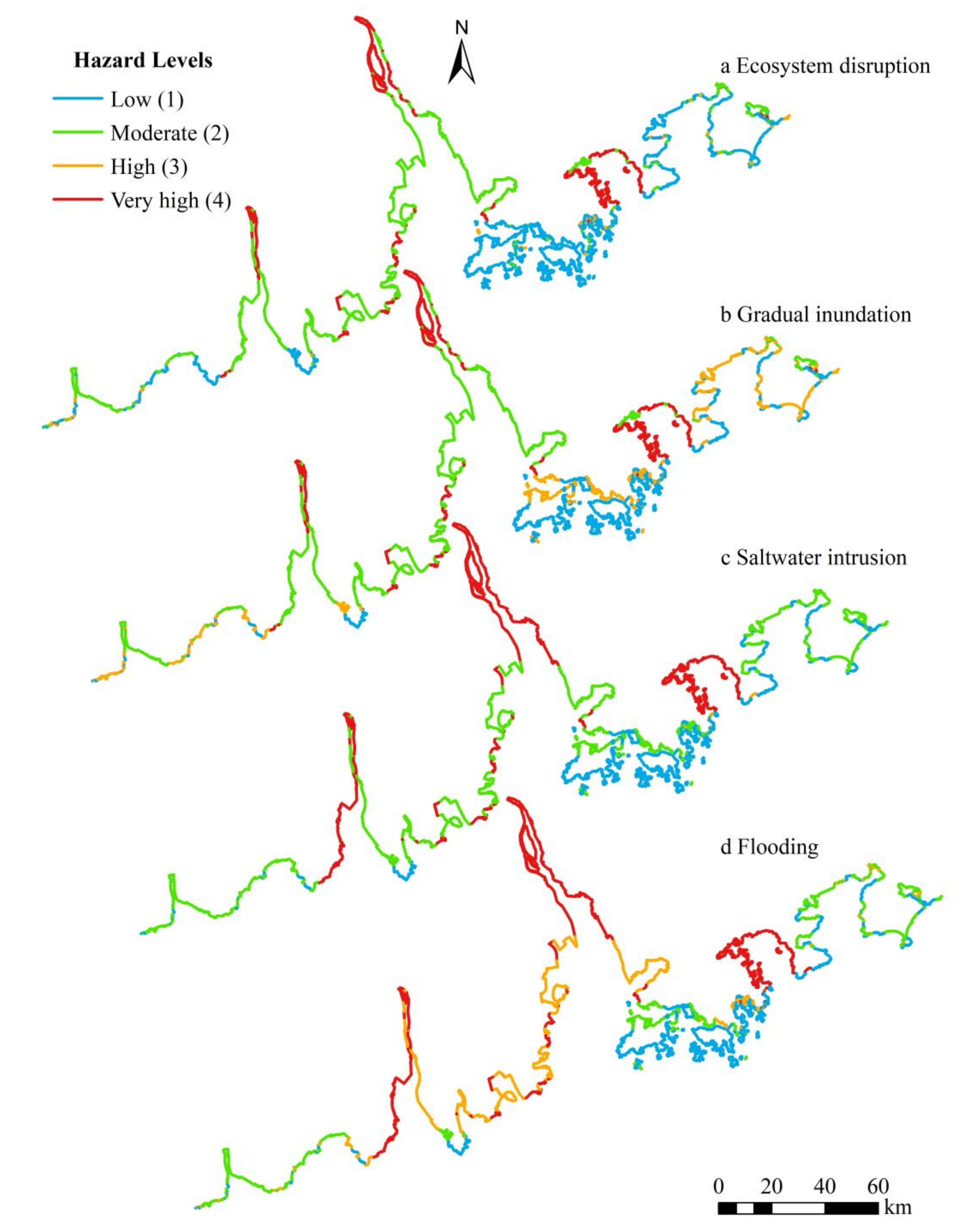
3.3. Coastal Vulnerabilities

Table 3 identifies five interdependent hazard types, namely, ecosystem disruption, gradual inundation, saltwater intrusion, erosion and flooding. According to the vulnerability level, each hazard is classified into levels 1, 2, 3 and 4, which represent low, moderate, high and very high risk, respectively. Add together the proportion of high risks and very high risks to study the types of high-risk hazards in GBA. The high-risk proportion of the five hazard types in 2020 is 21.45%, 37.67%, 27.55%, 19.96% and 48.23%, respectively. Therefore, it can be considered that GBA is mainly affected by flooding, gradual inundation, saltwater intrusion and ecosystem disruption hazards. The risk of erosion hazard is low.
From 2010 to 2020, the proportion of high-risk of ecosystem disruption, gradual inundation, saltwater intrusion and erosion decreased significantly, and the risk of ecosystem disruption decreased the most (−8.72%). The high risk of flooding increased and the very high risk decreased, remaining the highest risk hazard type in GBA, with the proportion of 47.95% and 48.23% in 2010 and 2020, respectively.
The hazard distribution of GBA in 2010 and 2020 was consistent, as shown in Figure 5, with the highest risk of flooding. Hazards are interdependent and affect each other. Areas affected by high-risk flooding are also affected by gradual inundation, saltwater intrusion and other hazards. The very high risk areas for ecosystem disruption (Figure 5a), gradual inundation (Figure 5b), salt water intrusion (Figure 5c) and flooding (Figure 5d) are mainly located at PRE, the east bank of Yamen Waterway, the west bank of Huangmao Sea and Dapeng Bay. Moderate-high risk areas are mainly distributed in Lingdingyang Estuary, Huangmao Sea, Zhenhai Bay and Daya Bay. Hong Kong and the west coast of Daya Bay are low risk areas. According to the distribution characteristics of hazards, deltas and low flat areas, low-moderate wave exposure, micro tidal range, marshes and mangroves distribution areas, deposit or balance state of the coast, and the influence of tropical cyclone activities are prone to high-grade ecosystem disruption, gradual inundation, saltwater intrusion and flooding hazards.

4. Discussion

4.1. Applicability of CHW

Coastal vulnerability studies based on CHW have not been conducted in the study area of China, and their applicability needs to be investigated in combination with previous studies or field surveys. Xiao [19], Xu et al. [25] and Li [26], used CVI, principal component analysis (PCA) and analytic hierarchy process (AHP) to assess the ecological vulnerability or coastal vulnerability of the PRD, and their coastal vulnerability distribution results are basically consistent with this paper, that is, the central parts of the GBA were highly vulnerable areas, while the eastern and western parts were moderate-low vulnerability areas. From government reports and statistical yearbooks, it is known that GBA has a high frequency of flooding and is vulnerable to typhoons, which occurred more than 150 times from 1949 to 2020, causing direct economic losses of up to 100 billion yuan. Compared with previous studies, this paper has superiority in spatial and temporal scales by using coastline, wave height and tidal range as the main data to study the vulnerability of GBA as a whole and analyze its hazard change process from 2010 to 2020. CHW is intended to provide the first hazard assessment for a relatively large study area at a spatial scale and provides a preliminary understanding of coastal vulnerability or hazard assessment in GBA that is applicable.

4.2. Management of Coastal Vulnerability

According to the coastal types and management options from Appelquist et al. [31], coastal zoning, Ecosystem based management, Tsunami warning system, wetland restoration and hazard simulation are the most widely applied measures in theory and they are all soft measures. Coastal zoning is applicable to all coasts and hazard types. From hazard analysis, it can be seen that flooding and gradual inundation are the prominent high hazards in GBA, and the high risk area is located in DE coast. Therefore, in addition to the above five measures, embankment projects should be built to improve the management of agricultural systems, river deposits and groundwater, while paying attention to the function and implementation of flood mappings, flood shelters and flood warning systems to better resist gradual inundation and flooding hazards. At present, there is insufficient research on the overall monitoring-early warning- emergency-information management system and overall prevention and control measures for coastal vulnerability in GBA, and the protection means are mostly hard measures that are vulnerable to loss, such as water conservancy hubs, dikes and other gray infrastructure for hazard prevention [24]. In recent years, people have gradually realized the advantages of non-engineering measures such as early warning and forecasting system, and soft measures are more autonomous and adaptable to cope with the impact of climate change more effectively.

4.3. Characteristics of CHW

As a risk assessment tool, CHW has the following characteristics. It is based on publicly available data sources and considers essentially all hydrological coastal environments around the world, which is time and cost efficient, especially for developing countries with scarce data [37]. The first hazard assessment can be obtained with the help of fewer data, providing a framework for rapid assessment of coastal hazards in a large study area and the development of management options. This is the most prominent feature of CHW that distinguishes it from other coastal assessment methods. However, the resolution of the global public data is limited. For example, wave exposure is currently used to represent the offshore wave climate with a resolution of 0.5°. The nearshore water depth and the angle of incident waves relative to the coastline are not taken into account, so there are errors in the estimation of wave climate. Therefore, more accurate local data would improve the assessment of CHW [16]. Moreover, Google earth images have relatively high resolution, but due to the large GBA range, there are problems such as different image time, low image resolution in some areas and different image sizes in the same place, which will have a greater impact on sediment balance [33]. At the same time, it is necessary to further understand the characteristics of the study area in conjunction with field surveys to obtain more accurate vulnerability assessment results for better hazard prevention construction and loss assessment [17]. Consider adding socio-economic factors, the future trend, such as in addition to the impact of natural factors, impervious surfaces can also exacerbate urban flooding.

4.4. Guiding Significance

GBA is in the stage of rapid development and the regional elements are intercoupled and interlinked. The large-scale development and construction activities will inevitably aggravate the vulnerability of the Bay Area. For example, artificial sand mining causes undercutting of the river channel and changes the water flow system, which affects the drainage of flood, the siltation of the estuary and the intrusion of seawater. Excessive groundwater pumping and artificial construction will lead to land subsidence, karst collapse and other hazards. Rapid urbanization may lead to reclamation and wetland reduction [24]. From 1978–2002, pond farming expanded rapidly; after 2002, urban construction activities, such as town sites, port terminals and waterfront industries were the main types of reclamation. At the same time, sea level rise has seriously threatened low-lying islands and coastal areas, and the trend of tide level changes at all tidal stations in GBA over the past 40 years shows that sea level rise is accelerating, which is one of the most important factors leading to the vulnerability of coastal zones. Sea level rise is a cumulative process that will aggravate the risk of coastal lowland inundation, coastal storm surges, saltwater intrusion and flooding, continuing to affect coastal stability. This study helps to optimize the pattern of development and utilization of land space in the Greater Bay Area, to mediate the development scale of cities, and to strengthen the management of the hazard sites and natural hazard potential spots that have already occurred.
This study has implications for coastal vulnerability or hazard assessment in other major River Deltas or the Bay Area. For example, the coastal type of the Yangtze River Delta is mostly silty plain coast with typical delta type, which is susceptible to erosion and flooding. At present, research on flooding in the Yangtze River Delta are mostly focused on loss assessment and risk analysis, and few literatures have studied the vulnerability of flooding in this region [46]. At the same time, the indicator data of the Yangtze River Delta is relatively complete, and the study of its erosion and flooding using CHW method can obtain accurate assessment results.

5. Conclusions

This paper used CHW to study the major hazard hotspots and management measures along GBA coast. CHW basically considers all hydrological coastal environments around the world, enables the first hazard assessment to be obtained at a relatively large spatial scale, and without too many data requirements. CHW is applicable to vulnerability assessments of the GBA. The results found that GBA is at high risk of flooding and geomorphic factors have a great influence on hazards. The type and distribution of GBA coast was consistent from 2010 to 2020, and was dominated by DE (43.86%) and R (30.43%) types. In 2020, strong wave exposure, diverse vegetation types and significant seaward siltation have led to a more detailed classification of coastal types, which in turn affects coastal hazard risk. Flooding, gradual inundation, saltwater intrusion and ecosystem disruption are high risk hazard in GBA. Compared with 2010, the proportion of high risk hazard caused by ecosystem disruption, gradual inundation, salt water intrusion and erosion decreased significantly in 2020, among which the risk of ecosystem disruption decreased the most. At present, there are few protective measures against coastal hazards in GBA. In the future, it is necessary to strengthen the research on soft measures to deal with gradual inundation and flooding hazards and improve the overall prevention and control of coastal monitoring—early warning-emergency-information management system. At the same time, attention should be paid to the coupling and chain effect of various elements in the development process of GBA and the influence of sea level rise. This study is helpful for policy makers in planning and management of the Bay Area, ensuring hazard prevention safety and sustainable development of GBA, and providing reference for research on coastal hazards in other major River Deltas or the Bay Area.

Author Contributions

Q.S. conceived, designed and performed the designs and drafted this paper, Z.L., G.L., D.Z. and P.H. reviewed and edited this paper. All authors have read and agreed to the published version of the manuscript.

Funding

This research was funded by The National Natural Science Foundation of China (grant no. 42176167), Innovation Fund of Guangdong Ocean University (grant no. Q18307), the program for scientific research start-up funds of Guangdong Ocean University (grant no. 060302112010).

Institutional Review Board Statement

Not applicable.

Informed Consent Statement

Not applicable.

Data Availability Statement

Not applicable.

Acknowledgments

We would like to thank all the quality professionals who helped the research, for their insightful and constructive comments.

Conflicts of Interest

The authors declare no conflict of interest.

References

  1. Zhao, M.; Kou, J.; Yang, J.; Zhao, W. Study on the ecological security and protection measures of the coastal zone in Guangdong-Hong Kong-Macao Greater Bay Area. Environ. Prot. 2019, 47, 29–34. [Google Scholar]
  2. Wang, N.; Zhang, L.; Yuan, L.; Cao, H. Research into vulnerability assessment for coastal zones in the context of climate change. Acta Ecol. Sin. 2012, 32, 2248–2258. [Google Scholar] [CrossRef]
  3. Wang, T.; Zhou, X.; Li, B. Research progress of coastal vulnerability to varied driving factors. Mar. Sci. Bull. 2015, 34, 361–369. [Google Scholar]
  4. Chen, X.; Zuo, B.; Liu, X.; Huang, L. Research review of the evaluation methods of ecosystem vulnerability of coastal zones. J. Henan Inst. Sci. Technol. (Nat. Sci. Ed.) 2020, 48, 25–34. [Google Scholar]
  5. Gong, Q.; Zhang, H.; Ye, Y.; Yuan, S. Planning strategy of land and space ecological restoration under the framework of man-land system coupling: Take the Guangdong-Hong Kong-Macao Greater BayArea as an example. Geogr. Res. 2020, 39, 2176–2188. [Google Scholar]
  6. Wang, J.; Gong, Q.; Yu, Y.; Yuan, S.; Chen, J.; Huang, G. Evaluation of comprehensive disaster-bearing capacity of urban natural disasters in the Guangdong-Hong Kong-Macao Greater BayArea. Geogr. Res. 2020, 39, 2189–2199. [Google Scholar]
  7. Adger, W. Vulnerability. Glob. Environ. Chang. 2006, 16, 268–281. [Google Scholar] [CrossRef]
  8. Fang, X.; Yin, P. Review on the three key concepts of resilience, vulnerability and adaptation in the research of global environmental change. Prog. Geogr. 2007, 5, 11–22. [Google Scholar]
  9. Chu, J.; Gao, S.; Xu, J. Risk and safety evaluation methodologies for coastal systems: A review. Mar. Sci. Bull. 2005, 3, 80–87. [Google Scholar]
  10. Bukvic, A.; Rohat, G.; Apotsos, A.; Sherbinin, A.D. A systematic review of coastal vulnerability mapping. Sustainability 2020, 12, 2822. [Google Scholar] [CrossRef] [Green Version]
  11. Narra, P.; Coelho, C.; Sancho, F.; Palalane, J. CERA:Anopen-source tool for coastal erosion risk assessment. Ocean Coast. Manag. 2017, 142, 1–14. [Google Scholar] [CrossRef]
  12. Gornitz, V. Global coastal hazards from future sea level rise. Palaeogeogr. Palaeoclimatol. Palaeoecol. 1991, 89, 379–398. [Google Scholar] [CrossRef]
  13. Sharples, C. Indicative mapping of Tasmanian coastal geomorphic vulnerability to sea-level rise using GIS line map of coastal geomorphic attributes. Wollongong Pap. Marit. Policy 2006, 16, 235–247. [Google Scholar]
  14. Appelquist, L.R. Generic framework for meso-scale assessment of climate change hazards in coastal environments. J. Coast. Conserv. 2013, 17, 59–74. [Google Scholar] [CrossRef] [Green Version]
  15. Viavattene, C.; Jimenez, J.A.; Ferreira, O.; Priest, S.; Owen, D.; McCall, R. Selecting coastal hotspots to storm impacts at the regional scale: A Coastal Risk Assessment Framework. Coast. Eng. 2018, 134, 33–47. [Google Scholar] [CrossRef]
  16. Narra, P.; Coelho, C.; Sancho, F.; Escudero, M.; Silva, R. Coastal hazard assessments for sandy coasts: Appraisal of five methodologies. J. Coast. Res. 2019, 35, 574–583. [Google Scholar] [CrossRef]
  17. Anfuso, G.; Postacchini, M.; Luccio, D.D.; Benassai, G. Coastal sensitivity/vulnerability characterization and adaptation strategies: A review. J. Mar. Sci. Eng. 2021, 9, 72. [Google Scholar] [CrossRef]
  18. Yue, Z.; Li, L.; Xu, Y.; Cui, J.; Xue, C. Method and application of environmental vulnerability evaluation in Great River Deltas. Saf. Environ. Eng. 2019, 26, 114–121. [Google Scholar]
  19. Xiao, Y. Assessment of Coastal Vulnerabiliy to Sea-Level Rise: Preliminay Results for the Coastlines along the Pearl River Mouth. Master’s Thesis, South China Normal University, Guangzhou, China, 2003. [Google Scholar]
  20. Liu, X.; Shen, F. Fuzzy comprehensive assessment on the Yanctze River Delta coastal erosion vulnerability. Resour. Environ. Yangtze Basin 2010, S1, 199–203. [Google Scholar]
  21. Liu, X.; Chen, S.; Jiang, C.; Hu, J.; Zhang, L. Vulnerability assessment of coastal erosion along the Abandoned Yellow River Delta of northern Jiangsu, China. Acta Geogr. Sin. 2014, 69, 607–618. [Google Scholar]
  22. Tang, B.; Lv, Z.; Lin, L. Temporal and spatial pattern evolution and regulation path of economic vulnerability in Pearl River Delta urban agglomeration. Areal Res. Dev. 2020, 39, 13–18. [Google Scholar]
  23. Wu, J.; Yang, A. The analysis of regional economic vulnerability and obstacle factors of Guangdong Province based on Set Pair Analysis. Econ. Geogr. 2012, 32, 32–38. [Google Scholar]
  24. Han, X.; Long, J.; Li, J.; Chu, F.; Zhang, P.; Xu, D.; Yang, H. Research progress on the vulnerability of the Pearl River Delta. Trop. Geogr. 2010, 30, 1–7. [Google Scholar]
  25. Xu, Q.; Huang, M.; Liu, H.; Yan, H. Integrated assessment of eco-environmental vulnerability in Pearl River Delta based on RS and GIS. Chin. J. Appl. Ecol. 2011, 22, 2987–2995. [Google Scholar]
  26. Li, D. Study on Vulnerability Assessment Model of Chinese Large River Delta Based on Analytic Hierarchy Process. Master’s Thesis, China University of Petroleum, Qingdao, China, 2012. [Google Scholar]
  27. He, Y.; Kuang, Y. Evaluation and analysis of ecological security of coastal zone in Huizhou of Guangdong Hong Kong-Macao Greater Bay Area based on DPSIR mode. Environ. Pollut. Control 2020, 42, 362–368. [Google Scholar]
  28. Wang, S.; Mu, L.; Qi, M.; Yu, Z.; Yao, Z.; Zhao, E. Quantitative risk assessment of storm surge using gis techniques and open data: A case study of daya bay zone, china. J. Environ. Manag. 2021, 289, 112514. [Google Scholar] [CrossRef]
  29. Wang, J.; Wen, Z. The ecological restoration strategy of estuary coastal zone in Guangdong-Hong Kong-Macao Greater Bay Area: Take Dong guan Marina Bay New Area as an example. Ocean Dev. Manag. 2020, 37, 34–39. [Google Scholar]
  30. Gong, Q.; Ye, Y.; Wang, J.; Liu, B.; Li, Z. Resilient disaster prevention space planning of Guangdong-Hong Kong-Macao Great Bay Area. Planners 2021, 37, 22–27. [Google Scholar]
  31. Appelquist, L.R.; Balstrøm, T.; Halsnæs, K. Managing Climate Change Hazards in Coastal Areas: The Coastal Hazard Wheel Decision-support System; United Nations Environment Programme: Nairobi, Kenya, 2016. [Google Scholar]
  32. Appelquist, L.R.; Balstrøm, T. Application of the Coastal Hazard Wheel methodology for coastal multi-hazard assessment and management in the state of Djibouti. Clim. Risk Manag. 2014, 3, 79–95. [Google Scholar] [CrossRef] [Green Version]
  33. Appelquist, L.R.; Balstrøm, T. Application of a new methodology for coastal multi-hazard-assessment & management on the state of Karnataka, India. J. Environ. Manag. 2015, 152, 1–10. [Google Scholar]
  34. Appelquist, L.R.; Halsnæs, K. The Coastal Hazard Wheel system for coastal multi-hazard assessment & management in a changing climate. J. Coast. Conserv. 2015, 19, 157–179. [Google Scholar]
  35. Micallef, S.; Micallef, A.; Galdies, C. Application of the Coastal Hazard Wheel to assess erosion on the Maltese coast. Ocean Coast. Manag. 2018, 156, 209–222. [Google Scholar] [CrossRef] [Green Version]
  36. Stronkhorst, J.; Levering, A.; Hendriksen, G.; Rangel-Buitrago, N. Regional coastal erosion assessment based on global open access data: A case study for Colombia. J. Coast. Conserv. 2018, 22, 787–798. [Google Scholar] [CrossRef] [Green Version]
  37. Paul, S.; Das, C.S. Delineating the coastal vulnerability using Coastal Hazard Wheel: A study of West Bengal coast, India. Reg. Stud. Mar. Sci. 2021, 44, 101794. [Google Scholar] [CrossRef]
  38. Liu, X.; Deng, R.; Xu, J.; Gong, Q. Spatiotemporal evolution characteristics of coastlines and driving force analysis of the Pearl River Estuary in the past 40 years. Geo-Inf. Sci. 2017, 19, 1336–1345. [Google Scholar]
  39. Zhang, Y. 2014. Analyzing shoreline changes of the Pearl River Estuary based on remote sensing in recent forty years. Master’s Thesis, Inner Mongolia Normal University, Hohhot, China, 2014. [Google Scholar]
  40. Xing, J.; Meng, D.; Bai, Q.; Li, Y. Analysis of coastline changes of Chinese estuaries and its driving factors in the past 30 years. J. Cap. Norm. Univ. (Nat. Sci. Ed.) 2021, 42, 58–65. [Google Scholar]
  41. Han, Y.; Gao, J.; Li, Z.; Liu, Y. The main ecological environment problems and protection countermeasures in the Pearl River Delta coastal zone. Ocean Dev. Manag. 2005, 3, 84–87. [Google Scholar]
  42. Alder, J. Global Estuary Database. United Nations Environment Programme. 2016. Available online: http://data.unep-wcmc.org/datasets/23 (accessed on 14 June 2020).
  43. Su, Q.; Li, Z. Coastline Types and Their Spatiotemporal Variations in Guangdong, Hong Kong and Macao Bay Area (1979–2020). Digit. J. Glob. Chang. Data Repos. 2021. [Google Scholar] [CrossRef]
  44. Liu, L.; Zhang, X.; Chen, X.; Gao, Y.; Mi, J. GLC_FCS30-2020: Global Land Cover with Fine Classification System at 30 m in 2020 (Version v1.2). Zenodo. 2020. [CrossRef]
  45. Chen, B.; Xiao, X.; Li, X.; Pan, L.; Russell, D.; Ma, J.; Dong, J.; Qin, Y.; Zhao, B.; Wu, Z.; et al. Spatial distribution data of mangroves in China in 2015. Digit. J. Glob. Chang. Data Repos. 2017. [CrossRef]
  46. Wang, J.; She, J. Vulnerability assessment and influencing factors analysis of urban flood disaster in Yangtze River Delta city cluster. J. Hohai Univ. (Philos. Soc. Sci.) 2020, 22, 39–45. [Google Scholar]
Figure 1. The geographical location of the GBA.
Sustainability 13 12623 g001
Figure 2. Coastal classification and inherent hazard level from Coastal Hazard Wheel version 3.0 [31].
Sustainability 13 12623 g002
Figure 3. Main input layers of GBA in 2020 for CHW. (a) Geological layout (b) tidal range map (c) character of sediment balance.
Sustainability 13 12623 g003
Figure 4. Coastal classification map of GBA in 2020. In the classification code PL stands for sediment plain, SR for slop soft rock, FR for flat hard rock, R for sloping hard rock, and DE for delta/low estuarine island. Only show coast types with a percentage greater than 0.5%.
Sustainability 13 12623 g004
Figure 5. Coastal hazard map for GBA in 2020. (a) ecosystem disruption. (b) gradual inundation. (c) saltwater intrusion. (d) flooding.
Sustainability 13 12623 g005
Table 1. Data sources and classification criteria for this study.
VariableCategoryAuthor(s)Classification Parameters
Geological layoutSedimentary plainNASA/China Geological Survey/Su et al. [43]Soft rock and slope < 20°
Slop soft rockSoft rock and slope ≥ 20°
Flat hard rockHard rock and slope < 20°
Sloping hard rockHard rock and slope ≥ 20°
Delta, low estuarine islandsAlder [42]Intersection with area
Wave exposureProtectedECMWF (2020)Hs < 2 m
Moderately exposedHs 2–4 m
ExposedHs > 4 m
Tidal rangeMicro tidalChina Oceanic Information Network (2020)Range < 2 m
Meso tidalRange 2–4 m
Macro tidalRange > 4 m
VegetationVegetatedLiu et al. [44]classes 10–153
Not vegetatedclasses > = 190
Marshesclasses 180
MangrovesChen et al. [45]The distribution of mangroves
Sediment balanceBalance/deficit/surplusSu et al. [43]Accretion based on seaward shift of coastline from 1980
Beach/no beachgravel coastline
Storm climateTropical cyclone activityTyphoon OnlineTropical cyclone activity occurs or is affected by it
Table 2. Major coastal types and their geological, hydrological, biological, and morphological character along GBA.
Coastal ClassInput LayersPercentage
GeologyWave ExposureTidal RangeFloraSediment BalanceStorm Climate20102020
PL-5Sediment PlainModeratelyAnyAnyD/BYes-7.170.31 6.44
PL-6MicroNo-1.36
PL-8Surplus-3.55
PL-12ProtectedMarsh-0.06
PL-13MangrovesBalanceYes0.34 0.02
PL-14No2.36 0.12
PL-16Surplus4.47 0.93
PL-18MesoMarshBalance-0.07
SR-10Slop Soft RockModeratelyMicroNot veget0.47 1.880.47 1.57
SR-14Anyvege0.02 -
SR-17ProtectedMicroAnyYes0.01 0.03
SR-18Not vegetNo0.75 0.79
SR-20AnySurplus0.63 0.27
FR-10Flat Hard RockModeratelyvegeNB0.27 17.560.26 17.71
FR-17ProtectedNot vegetAnyYes1.31 1.65
FR-18No12.61 12.63
FR-19Marsh/MangrovesYes1.18 0.90
FR-20No2.19 2.26
R-1Sloping Hard RockAnyAny30.64 30.6430.43 30.43
DE-11DeltaProtectedMarshSurplusYes-42.750.21 43.86
DE-12No0.08 -
DE-13MangrovesD/BYes13.61 12.58
DE-14No3.61 -
DE-15SurplusYes3.74 4.37
DE-16No10.38 15.10
DE-17MesoMarshD/BYes-0.07
DE-21Mangroves6.87 5.43
DE-23Surplus4.46 4.57
DE-24No-1.53
Table 3. The distribution of hazard levels in percent for GBA’s coast.
Type of HazardInherent Hazard Level
LowModerateHighVery HighHigh Hazard
2010202020102020201020202010202020102020Change
Ecosystem disruption45.93 45.72 23.90 32.83 3.37 3.17 26.79 18.28 30.17 21.45 −8.72
Gradual inundation32.52 32.00 23.13 30.34 17.56 19.38 26.79 18.28 44.36 37.67 −6.69
Saltwater intrusion32.52 32.00 34.85 40.45 3.95 0.33 28.68 27.22 32.63 27.55 −5.08
Erosion59.30 68.60 13.91 11.44 26.79 19.96 --26.79 19.96 −6.84
Flooding32.52 32.00 19.53 19.78 18.93 20.68 29.02 27.55 47.95 48.23 0.28
Publisher’s Note: MDPI stays neutral with regard to jurisdictional claims in published maps and institutional affiliations.

