
Landscape Works. Balancing Nature and Culture in the Pantelleria National Park


Abstract
:1. Introduction
2. General Overview
3. Materials and Methods
3.1. Case Study
3.2. Methodology to Read the Landscape at Different Scales
- -
- 0–3 species habitats: 0.15
- -
- 4–10 species habitats: 0.5
- -
- 11–14 species habitats: 0.9
4. Results
4.1. Features and Patterns
4.2. Landscape Systems and Subsystems, Zoning Proposal
5. Discussion
- -
- To control urbanized areas with the aim of maintaining the functional and perceptive relationship with the surrounding countryside;
- -
- To protect the fertility and permeability of the soil, authorising the extension of existing buildings in rural areas only in case of activities linked to agriculture production and transformation;
- -
- To protect the elements of the built heritage of historical-architectural value (as explained in Table 5) by providing specific directions for their restoration;
- -
- To reuse abandoned dammusi for purposes linked to the Park’s reception facilities;
- -
- To support entrepreneurs in transition to sustainable agricultural practices (e.g., research and assistance aimed at eliminating the use of pesticides not allowed in organic farming).
6. Conclusions
Author Contributions
Funding
Institutional Review Board Statement
Informed Consent Statement
Data Availability Statement
Acknowledgments
Conflicts of Interest
References
- Vogiatzakis, I.N.; Pungetti, G.; Mannion, A. (Eds.) Mediterranean Island Landscapes: Natural and Cultural Approaches; Landscape Series, 9; Springer Publishing: Dordrecht, The Netherlands, 2008; pp. 101–114. [Google Scholar]
- Grove, A.T.; Rackham, O. The Nature of Mediterranean Europe: An. Ecological History; Yale University Press: New Haven, CT, USA, 2001. [Google Scholar]
- Brown, J.; Mitchell, N.; Beresford, M. (Eds.) Protected landscapes: A conservation approach that links nature, culture and community. In The Protected Landscape Approach. Linking Nature, Culture and Community; IUCN: Gland, Switzerland, 2005; pp. 3–18. [Google Scholar]
- Palazzo, A.L.; Barbieri, L.; D’Ascanio, R.; De Pasquale, G.; Filpa, A. Natura e cultura: Conflitto o cooperazione? Riflessioni sul Parco Nazionale di Pantelleria. Urban. Inf. 2021, 295, 90–91. [Google Scholar]
- Italian Ministry for Ecological Transition. Law 394/91—Framework Law on Protected Areas; Italian Ministry for Ecological Transition: Rome, Italy, 1991.
- Hawkes, J. The Fourth Pillar of Sustainability. Culture’s Essential Role in Public Planning; Common Ground Publishing Pty Ltd.: Melbourne, Australia, 2001. [Google Scholar]
- Burgi, M.; Hersperger, A.M.; Schneeberger, N. Driving forces of landscape change—Current and new directions. Landsc. Ecol. 2004, 19, 857–868. [Google Scholar] [CrossRef]
- Bürgi, M.; Bieling, C.; Von Hackwitz, K.; Kizos, T.; Lieskovský, J.; Martín, M.G.; Printsmann, A. Processes and driving forces in changing cultural landscapes across Europe. Landsc. Ecol. 2017, 32, 2097–2112. [Google Scholar] [CrossRef] [Green Version]
- Council of Europe. The Declaration of Amsterdam: Congress on the European Architectural Heritage; Council of Europe: Strasbourg, France, 1975. [Google Scholar]
- Quatrémère de Quincy, A.C. Lettres sur le Préjudice Qu’occasionneroient aux Arts et à la Science le Déplacement des Monuments de l’Art en Italie, le Démembrement de ses Ecoles, et la Spoliation de ses Collections; Edition Macula: Paris, France, 1989; (Paris, 1796). [Google Scholar]
- UNESCO. Convention Concerning the Protection of the World Cultural and Natural Heritage; UNESCO: Paris, France, 1972. [Google Scholar]
- UNESCO. Operational Guidelines for the Implementation of the World Heritage Convention; UNESCO: Paris, France, 2015. [Google Scholar]
- UNESCO. Convention for the Safeguarding of Intangible Cultural Heritage, Paris, 2003. Available online: http://www.unesco.org/culture/ich/en/convention (accessed on 12 September 2021).
- Phillips, A. Management Guidelines for IUCN Category V Protected Areas: Protected Landscapes/Seascapes; IUCN: Gland, Switzerland; Cambridge, UK, 2002. [Google Scholar]
- Dudley, N. (Ed.) Guidelines for Applying Protected Area Management Categories; IUCN: Gland, Switzerland; Cambridge, UK, 2008; Available online: https://www.iucn.org/sites/dev/files/import/downloads/iucn_assignment_1.pdf (accessed on 28 October 2021).
- Mitchell, N.; Buggey, S. Protected Landscapes and Cultural Landscapes: Taking Advantage of Diverse Approaches. George Wright Forum 2000, 17, 35–46. [Google Scholar]
- Phillips, A. Cultural Landscapes: IUCN’s Changing Vision of Protected Areas. In UNESCO. Cultural Landscapes: The Challenges of Conservation; World Heritage Papers No. 7.; UNESCO World Heritage Centre: Paris, France, 2003; pp. 40–49. [Google Scholar]
- Phillips, A. Landscape as a meeting ground: Category V Protected Lanscapes/Seascapes and World Heritage Cultural Landscapes. In The Protected Landscape Approach: Linking Nature, Culture and Community; Brown, J., Mitchell, N., Beresford, M., Eds.; IUCN: Cambridge, UK, 2005; pp. 19–35. [Google Scholar]
- Palazzo, A.L.; Rizzo, B.M. Paesaggio, Storia e Partecipazione. La Convenzione Europea a San Marino; Officina: Rome, Italy, 2007; pp. 11–13. [Google Scholar]
- Council of Europe. European Landscape Convention; Council of Europe: Florence, Italy, 2000. [Google Scholar]
- CBD (Convention on Biological Diversity). Strategic Plan for Biodiversity 2011–2020, Including Aichi Biodiversity Targets, 2011. Available online: https://www.cbd.int/sp/ (accessed on 28 October 2021).
- Council of Europe. European Cultural Convention; Council of Europe: Paris, France, 1954. [Google Scholar]
- Council of Europe. Faro Convention, STCE n. 199/2006. Available online: http://www.coe.int/web/culture-and-heritage/faro-convention (accessed on 10 September 2021).
- Council of Europe. Convention on the Value of Cultural Heritage for Society; Council of Europe Treaty Series-No. 199, Faro; Council of Europe: Paris, France, 2005. [Google Scholar]
- Gambi, L. Una Geografia per la Storia; Einaudi: Torino, Italy, 1973. [Google Scholar]
- Rombai, L. Geografia Storica dell’Italia. Ambienti, Territori, Paesaggi; Le Monnier: Milano, Italy, 2015. [Google Scholar]
- Coppa, M. Studio Preliminare Piano Territoriale Paesistico della Costiera Amalfitana; Editoriale Umbra SAS: Foligno, Italy, 1972. [Google Scholar]
- Gambino, R. Piani paesistici. Uno sguardo d’insieme. Urbanistica 1988, 60, 6–23. [Google Scholar]
- Gambino, R. Il paesaggio edificato. Piani paesistici e prospettive di recupero. Recuperare 1989, 40, 33–45. [Google Scholar]
- Gambino, R. Conservare Innovare. Paesaggio Ambiente e Territorio; Einaudi: Torino, Italy, 1997. [Google Scholar]
- Gambino, R.; Peano, A. Nature Policies and Landscape Policies. Towards an Alliance; Springer: Dordrecht, The Netherlands, 2005. [Google Scholar]
- Gambino, R.; Sargolini, M. (Eds.) Mountain Landscapes. A Decision Support System for the Accessibility; List: Trento, Italy, 2013. [Google Scholar]
- Morandi, F.; Niccolini, F.; Sargolini, M. Parks and Territory. New Perspectives in Planning and Organization; List: Trento, Italy, 2012. [Google Scholar]
- Italian Ministry of Culture. Legislative Decree No. 42 of 22 January 2004, Code of the Cultural and Landscape Heritage; Italian Ministry of Culture: Rome, Italy, 2004.
- Calcara, P. Descrizione dell’isola di Pantelleria. Atti Accad. Sci. E Lett. 1853, 2, 44. [Google Scholar]
- Orsi, P. Pantelleria: Risultati di una Missione Archeologica; Tipografia della R. Accademia dei Lincei: Roma, Italy, 1899. [Google Scholar]
- Tommasini, G. Pantelleria. L’Universo Riv. Dell’istituto Geogr. Mil. 1965, 4, 35–48. [Google Scholar]
- Bonasera, F. L’isola di Pantelleria; Patron: Bologna, Italy, 1965. [Google Scholar]
- Barbera, G.; Cullotta, S.; Rossi-Doria, I.; Rühl, J.; Rossi-Doria, B. I Paesaggi a Terrazze in Sicilia: Metodologie Per L’Analisi, la Tutela e la Valorizzazione; Collana di Studi e Ricerche dell’Agenzia Regionale Protezione Ambiente: Palermo, Italy, 2010. [Google Scholar]
- Barbera, G.; La Mantia, T.; Quatrini, P. Il sistema agricolo delle terrazze dell’Isola di Pantelleria. In Proceedings of the Atti del IV International Conference on Dry Stone Construction, Palma de Mallorca, Spain, 28–30 September 1994; pp. 235–245. [Google Scholar]
- Barbera, G.; Rühl, J. Umanesimo della Pietra. I Terrazzamenti delle Isole del Canale di Sicilia: Tra Calcare e Vulcanico. In Paesaggi Rurali italiani-Tra Natura ed Agricoltura; Ministero dell’Ambiente della Tutela del Territorio e del Mare: Roma, Italy, 2009; pp. 178–181. [Google Scholar]
- De Pasquale, G. Paesaggi terrazzati dell’Italia meridionale: Un’analisi comparativa tra passato, presente e future. Ann. Ser. Hist. Sociol. 2018, 28, 709–724. [Google Scholar]
- Amico, V. Lexicon Topographicum Siculum; (Translated by G. Di Marzo); Tip. Morvillo: Palermo, Italy, 1855; Volume 1. [Google Scholar]
- Cattani, M.; Tusa, S. Paesaggio agro-Pastorale e spazio rituale nell’età del Bronzo a Pantelleria. In Proceedings of the XLI Riunione Scientifica, San Cipirello, Italy, 16–19 November 2006. [Google Scholar]
- D’aietti, A. Il Libro Dell’isola di Pantelleria; Trevi Editore: Milano, Italy, 1978. [Google Scholar]
- D’aietti, G. Pantelleria. L’isola di Terra; Il Pettirosso: Mazara del Vallo, Italy, 2015. [Google Scholar]
- Calcara, P. Breve cenno sulla geognosia ed agricoltura dell’Isola di Pantelleria. G. Della Comm. Di Agric. E Pastor. Sicil. 1854, 3–4. [Google Scholar]
- Barbera, G.; La Mantia, T. Sistema agricolo e paesaggio nell’isola di Pantelleria. Italus Hortus 1988, 1, 23–28. [Google Scholar]
- Barbera, G.; Sganzerla, A. Pantelleria di Luce e Di Vento, di Pietra e di Fiori; Rizzoli: Milano, Italy, 2016. [Google Scholar]
- Brandi, C. Sicilia Mia; Sellerio: Palermo, Italy, 1989. [Google Scholar]
- Di Lorenzo, R.; Sottile, I. Aspetti e problemi della viticoltura dell’isola di Pantelleria. Agricoltura 1990, 209, 94–97. [Google Scholar]
- Giuntoli, G. Evoluzione del dammuso nel paesaggio antropizzato. In Relazione Allegata al Piano Territoriale Paesistico; Pantelleria, Italy, 1997. [Google Scholar]
- Brignone, F. I Giardini Dell’isola di Pantelleria; Litotipografia Nuova Stampa: Trapani, Italy, 2012. [Google Scholar]
- Brignone, F. U Jardinu; Dario Flaccovio Edtore: Palermo, Italy, 2001. [Google Scholar]
- Barbera, G.; Chieco, C.; Georgiadis, T.; Motisi, A.; Rossi, F. The jardinu of Pantelleria as a paradigm of resource efficient horticulture in the built-up environment. Acta Hortic 2018, 1215, 351–356. [Google Scholar] [CrossRef]
- De Pasquale, G.; Savelli, S. Intangible Heritage between Landscape Protection and Territory Development. A Plan for the Island of Pantelleria. In Proceedings of the XVIII International Forum, World Heritage and Contamination; Gangemi Editor International Publishing: Roma, Italy, 2020; pp. 760–765. [Google Scholar]
- De Pasquale, G. Il Paesaggio Rurale Tradizionale Dell’Isola di Pantelleria, Collana; I Quaderni del Parco: Pantelleria, Italy, 2020; Volume 1. [Google Scholar]
- De Pasquale, G.; Ganciu, A.; Lotta, F.; Savelli, S. Il Paesaggio Della Pietra a Secco Dell’Isola di Pantelleria, Dossier di Candidatura al Registro Nazionale dei Paesaggi Rurali Storici, 2018. Available online: https://www.reterurale.it/flex/cm/pages/ServeBLOB.php/L/IT/IDPagina/17423 (accessed on 25 September 2021).
- Desplanques, H. Il paesaggio rurale della cultura promiscua in Italia. Riv. Geogr. Ital. 1959, 29–64. [Google Scholar]
- Bevilacqua, P. Tra Natura e Storia. Ambiente, Economie, Risorse in Italia; Donzelli: Roma, Italy, 2000. [Google Scholar]
- Agnoletti, M. (Ed.) Paesaggi Rurali Storici: Per un Catalogo Nazionale; Laterza: Roma, Italy, 2010. [Google Scholar]
- Agnoletti, M.; Neri Serneri, S. (Eds.) The Basic Environmental History; Springer International Publishing: Cham, Switzerland, 2014. [Google Scholar]
- Phillips, A. The nature of cultural landscapes-A nature conservation perspective. Landsc. Res. 1998, 23, 21–38. [Google Scholar] [CrossRef]
- Phillips, A. Turning Ideas on Their Head: The New Paradigm of Protected Areas. Georg. Wright Forum 2006, 20, 8–32. [Google Scholar]
- Ervin, J.; Mulongoy, K.J.; Lawrence, K.; Game, E.; Sheppard, D.; Bridgewater, P.; Bennett, G.; Gidda, S.B.; Bos, P. Making Protected Areas Relevant: A guide to integrating protected areas into wider landscapes, seascapes and sectoral plans and strategies. CBD Tech. Ser. 2010, 44, 94. [Google Scholar]
- Dudley, N.; Stolton, S. Protected Landscapes and Wild Biodiversity, Volume 3. In The Values of Protected Landscapes and Seascapes Series; IUCN: Gland, Switzerland, 2012; p. 104. [Google Scholar]
- Sereni, E. Storia del Paesaggio Agrario Italiano; Laterza: Bari, Italy, 1961. [Google Scholar]
- Komnitsas, K.A.; Doula, M.K. Framework to improve sustainability of agriculture in small islands: The case of Pistacia vera L. cultivation in Aegina, Greece. Environ. Forensics 2017, 18, 214–225. [Google Scholar] [CrossRef]
- De Pasquale, G. Tutelare le pratiche agricole eroiche. Il ruolo del paesaggio e del Progetto. In Paesaggi terrazzati: Scelte per il Futuro/Terraced Landscapes: Choosing the Future; Alberti, F., Dal Pozzo, A., Murtas, D., Salas, M.A., Tillman, T., Eds.; Regione del Veneto: Venezia, Italy, 2018; pp. 493–498. [Google Scholar]
- Carl, T.; Richter, M. Geoecological and morphological processes on abandoned vine-Terraces in the Cinque Terre (Liguria). Geoökodynamik 1989, 10, 125–158. [Google Scholar]
- Rühl, J. Vascular Plant Diversity in Abandoned Vine and Caper Cultures of Pantelleria Island (Sicily) and Conclusions for Landscape Conservation. Master’s Thesis, Ernst Moritz Arndt-Universitaet, Greifswald, Germany, 2003. [Google Scholar]
- Rühl, J. Analisi dei processi di rinaturalizzazione nei vigneti e cappereti abbandonati del paesaggio terrazzato di Pantelleria (Canale di Sicilia). Nat. Sicil. 2004, 4, 3–4. [Google Scholar]
- Baratta, B.; Barbera, G. La forma di allevamento nell’olivicoltura di Pantelleria. Frutticoltura 1981, 12, 43–45. [Google Scholar]
- Barbera, G. Il Cappero; Edagricole: Bologna, Italy, 1993. [Google Scholar]
- Barbera, G.; Di Lorenzo, R. La coltura specializzata del cappero nell’isola di Pantelleria. Inf. Agrar. 1982, 32, 22113–22117. [Google Scholar]
- La Mantia, T. Foreste siciliane e rinaturalizzazione dell’isola di Pantelleria. Arpa View 2007, 13, 11–12. [Google Scholar]
- Brullo, S.; Di Martino, A.; Marcenò, C. La Vegetazione di Pantelleria; Istituto Botanico dell’Università di Catania: Catania, Italy, 1977. [Google Scholar]
- Gianguzzi, L. Vegetazione e bioclimatologia dell’isola di Pantelleria (Canale di Sicilia). Braun-Blanquetia 1999, 22, 1–70. [Google Scholar]
- Marsden, T.; Banks, J.; Bristonw, G. The social management of rural nature: Understanding agrarian based rural development. Environ Plan. A Econ. Space 2002, 34, 809–825. [Google Scholar] [CrossRef]
- Palazzo, A.L.; D’Ascanio, R.; Zaccardi, E. La Metafora Verde. Economie ed Ecologie di un’Area Interna del Lazio; Magaudda, S., Muccitelli, S., Palazzo, A.L., Eds.; iQuaderni di U3; 2020; Volume 24, pp. 15–25, in press. [Google Scholar]
- De Pasquale, G.; Barbieri, L.; Calcagnini, L.; D’Ascanio, R.; Desideri, P.; Filpa, A.; Formica, G.; Franciosini, L.; La Mantia, T.; La Mela Veca, D.S.; et al. Indirizzi di Tutela e Valorizzazione del Paesaggio Rurale dell’Isola di Pantelleria Propedeutico alla Redazione del Piano del Parco. Relazione Generale; Documento Consegnato Presso l’Ente Parco Nazionale Isola di Pantelleria: Pantelleria, Italy, 2021. [Google Scholar]
- EC. Communication from the Commission to the European Parliament, the Council, the European Economic and Social Committee and the Committee of the Regions. In EU Biodiversity Strategy for 2030. Bringing Nature Back into Our Lives; European Commission: Bruxelles, Belgium, 2020. [Google Scholar]
- Italian National Institute for Environmental Protection and Research (ISPRA) Progetto Piccole Isole. Available online: https://www.isprambiente.gov.it/it/archive/notizie-e-novita-normative/notizie-ispra/anno-2012/progetto-piccole-isole (accessed on 15 September 2021).
- Italian Government. The National Recovery and Resilience Plan (NRRP). 2021. Available online: https://www.governo.it/sites/governo.it/files/PNRR.pdf (accessed on 15 September 2021).
- Braudel, F. La Méditerranée. Espace et Histoire; Flammarion: Paris, France, 1988. [Google Scholar]
- Ministry for the Ecological Transition, Manuale per la Gestione dei siti Natura 2000. Available online: https://www.mite.gov.it/sites/default/files/archivio/allegati/rete_natura_2000/manuale_gestione_siti_natura2000.pdf (accessed on 26 September 2021).


| Ministry | Main Issues | Tools |
|---|---|---|
| Ministry of Culture | Entrusted with: culture, protection and conservation of artistic sites and landscape. | For Landscape planning the Decree n. 42/2004 provides Landscape Plans in co-decision between the Regions and the Ministry [34]. |
| Ministry for Ecological Transition | Entrusted among others with: the protection of biodiversity, ecosystem and marine and coastal resources, the safeguarding of land and waters, policies to combat climate change and global warming, sustainable development, energy efficiency and the circular economy. | For National Parks and Protected Areas, the Law 394/91 established a Park Authority in charge to develop the Regulations, the Park Management Plan and the Multi-Year Economic and Social Plan. |
| Ministry of Agricultural, Food and Forestry Policies | Entrusted with: government policy on agriculture, forests, food and fisheries at national, European and international level | The “National Register of rural landscapes of historical interest, agricultural practices and traditional knowledge” is part of the homonymous Observatory established by Decree n. 17,070 of 19 November 2012. The implementation of this tool is not mandatory. |
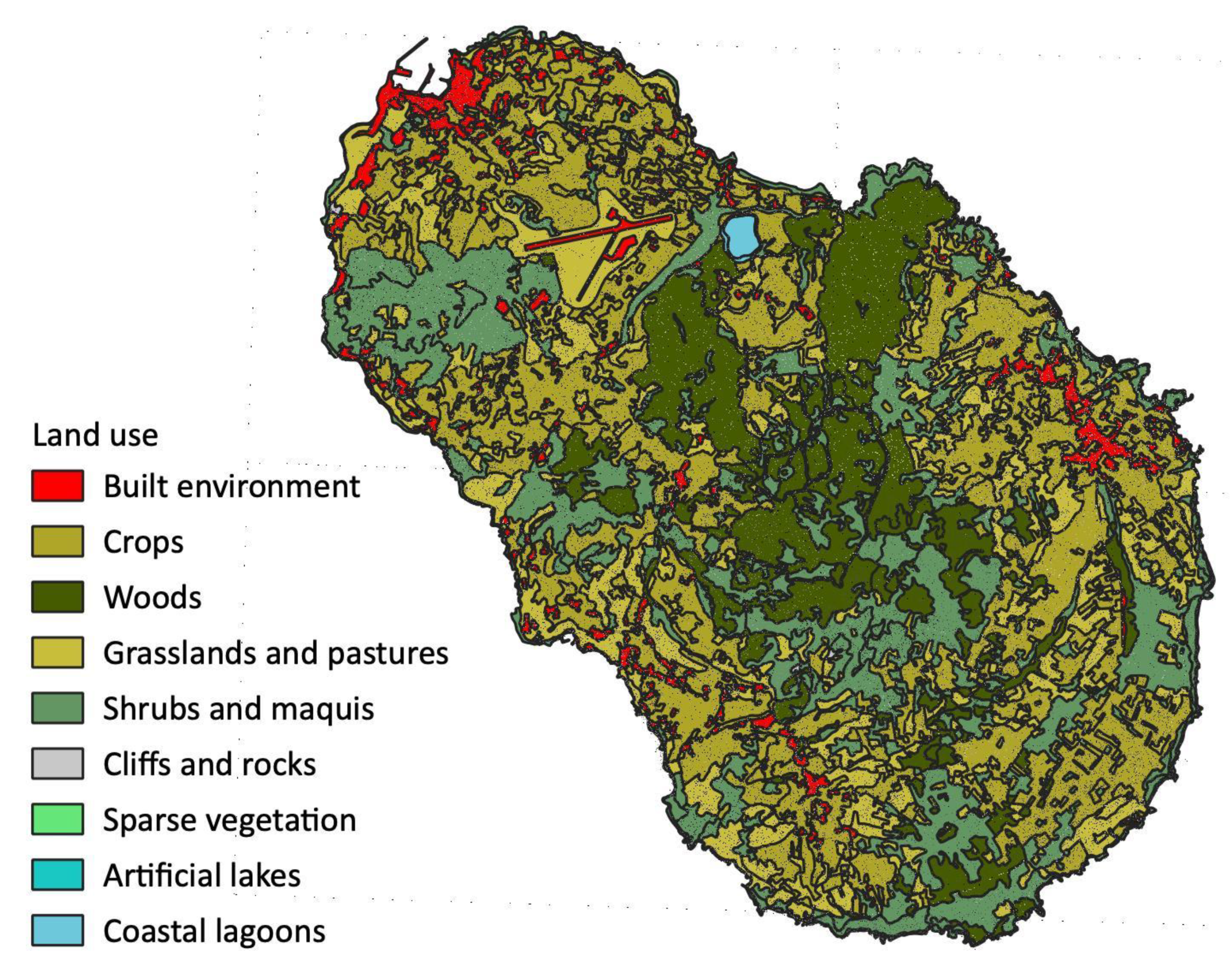
| Land Use | Area (ha) | Percentage |
|---|---|---|
| Built environment | 425.66 | 5.10% |
| Crops | 3078.75 | 36.91% |
| Woods | 1371.01 | 16.44% |
| Grasslands and pastures | 1399.45 | 16.78% |
| Shrubs and maquis | 2035.26 | 24.40% |
| Other (cliffs, vegetation, lakes and lagoons) | 31.55 | 0.38% |
| Total (percentages were rounded so the total value might be higher than 100) | 8341.67 | 100% |
| Phase | Documents Used | Description of the Process |
|---|---|---|
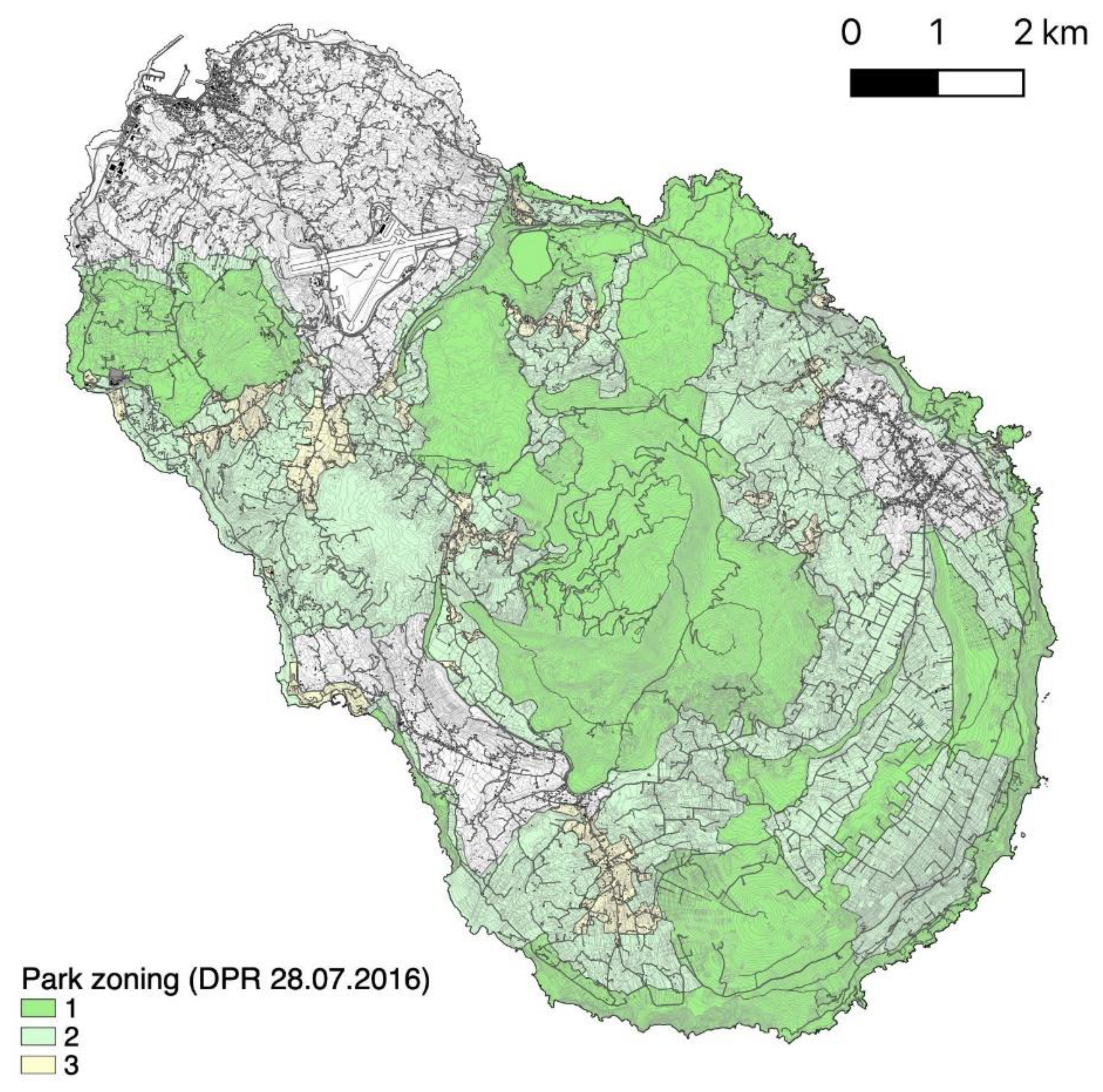
| Overlay of the original Park zoning to the regional base map (CTR) | Park zoning; Regional base map | The three zones of the park were overlaid to the regional base map as such: Zone 1, (relevant naturalistic, agricultural and historical landscape interest, with no or negligible urbanisation); Zone 2, (naturalistic, agricultural and/or historical value with limited urbanisation); Zone 3, (landscape and/or historical value, with high urbanisation). |
| Overlay of the original Park zoning to the Landscape plan areas | Park zoning; Landscape Plan | The overlay of the Park zoning to the 75 Landscape Plan areas. |
| Targeted reconfiguration of the Landscape plan areas | Park zoning | After the overlay, the researchers were able to identify 8 Landscape systems and 47 Subsystems within the National Park. This was carried out by (i) acknowledging the peculiarity of the coastal areas, (ii) aggregating some landscape areas with similar characteristics and protection regimes, and (iii) re-design of the settlements (villages and hamlets). |
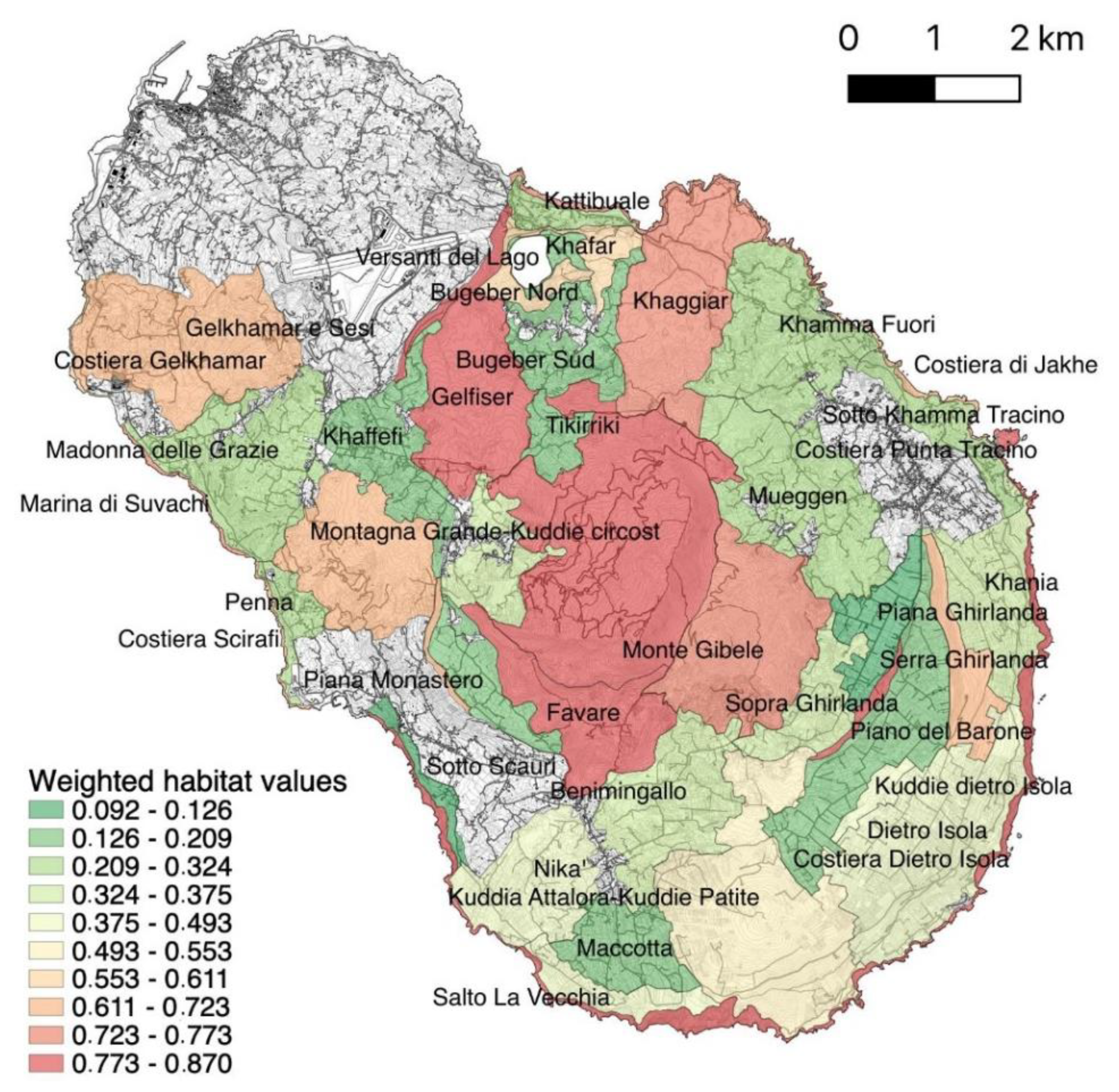
| Environmental quality assessment | Park zoning; Habitat map | The 47 Subsystems were then overlayed with the map of habitat quality within the management Plan of the Natura 2000 sites on the island. The values divided in 3 classes and weighted for each Subsystem, with values ranging from 0.09 to 0.87. |
| Name | Landscape View | Description |
|---|---|---|
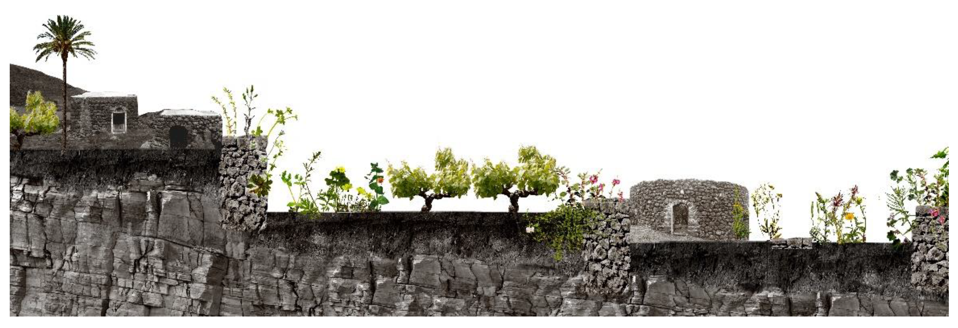
| Terrazzamento Terrace system | 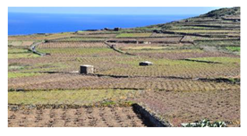 | Dry stone terracing is the main rural feature in the island. Their local variants mostly depend on geomorphology, availability of volcanic stones as for shapes and colours of the tiers, and on the depth of the cultivated areas [39,40,41,42]. |
| Dammuso | 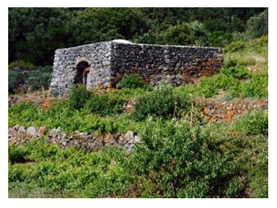 | The dammuso is the elementary architectural unit: a single volume made with dry stone masonry and covered by a vault. It generally has a single door and a single small window. Inside, niches of varying sizes (casene) are carved into the masonry. These buildings are intended for different agricultural and residential uses. Their unique, adaptive arrangements reflect the primordial needs of rural life shaping covered spaces in continuity with the agricultural plots [52]. |
| Giardino Garden | 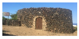 | The Pantelleria garden is most often a circular enclosure entirely built in dry stone to protect citrus trees inside from the harshness of the climate [53,54,55]. |
| Aira |  | The aira is a round structure occasionally marking the Pantelleria landscape, used for threshing barley. The floor is made of lapilli stone and lime mixed together and pressed. The circumference of the aira is delimited by a low stone wall used to keep the barley on the track trampled by the blindfolded donkey [35,38]. |
| Sesi | 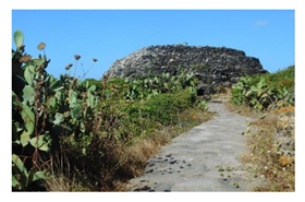 | Sesi are megalithic constructions present in the area of Mursia and Cimillia built by a northern African population who settled on the island about 5000 years ago during their invasion of southwestern Europe. They are truncated cone burial chambers with an elliptical or circular plan. They were erected outside the village walls on flatter areas. Nowadays, the Sesi Archaeological Park was established |
| Vineyards | 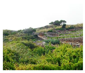 | The most widespread crop is the vine, the Pantelleria sapling, cultivated in pits about 20 cm deep, useful for accumulating rainwater and protecting the grapes from the wind. The Zibibbo variety is prevailing on the island, providing flavoured table grape, raisins and, above all, wine, notably the worldwide well-appreciated Passito di Pantelleria [51]. The traditional agricultural practice of cultivating the vite ad alberello (head-trained bush vines) of the community of Pantelleria was inscribed in 2014 in the Unesco WHL. |
| Olive groves |  | Olive trees are domesticated and almost trunkless. Their branches, weighed down by large stones and tied by vine shoots, bent and placed on the ground, imposing a horizontal, creeping and twisted development [73]. |
| Caper cultivations | 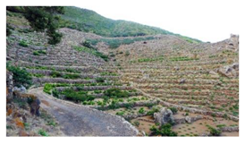 | The cultivation of the caper is the second most important on the island. In past times, it was collected from spontaneously born plants especially on sunny rock walls. Since the 1970s, the caper plant no longer occupies marginal lands, yet extends over small specialized plots, especially in the South West areas, where the climate is more arid and warm [74,75]. |
| Woodland |  | The low Mediterranean scrub grows from sea level up to 250 m of altitude; above 250 m a shrub-arboreal vegetation is the main feature. At altitudes above 500 m and in the valleys, the Quercus ilex woods are located. The thick layer of humus is home to numerous species, belonging to the mesofauna. [76,77,78] |
| Landscape System | Landscape Subsystem | Features |
|---|---|---|
| Falesie e coste marine (Coastal areas) | Costiera Dietro Isola, Costiera di Jakhe, Costiera Gelkhamar, Costiera Khaggiar, Costiera Punta Tracino, Costiera Scirafi, Marina di Suvachi | Coastal subsystems were carved out of the adjoining subsystems, in accordance with land morphologies and excluding inhabited areas, such as ports and hamlets. These areas, featuring a rocky environment, include vital habitats that represent the interface between sea and land. |
| Lago Specchio di Venere (Lake) | Bagno dell’acqua, Piane del Lago, Versanti del Lago | Lago Specchio di Venere contains an important habitat, a freshwater lake, that is threatened by nearby human activities. The Subsystems distinguish among the actual lake, the adjacent plains, and the slopes. |
| Grandi rilievi (Mountains) | Montagna Grande e Kuddie circostanti, Monte Gibele, Favara | This system contains mountain areas with highest environmental quality |
| Kuddie maggiori (Major hills) | Kuddia Attalora e Kuddie Patite, Kuddie Dietro Isola, Kuddia Sciuvechi | Some areas of these Subsystems belong to the coastal ones. They feature high environmental quality due to an increased presence of natural habitats |
| Colate laviche fratturate (Fractured lava flows) | Gelfiser, Gelkhamar e Sesi, Khafar, Khaggiar | |
| Orli Calderici (Caldera edges) | Orlo di Monastero e Zighidi, Orlo Ghirlanda, Orlo Zinedi, Serra Ghirlanda | One Subsystem (Orlo di Monastero e Zighidi) was slightly expanded in order to include an area worthy of protection. Some of these areas also feature high environmental quality due to an increased presence of natural habitats. |
| Versanti dei Coltivi e degli Ex Coltivi (Slopes of cultivations and former cultivations) | Benimingallo, Bugeber Nord, Bugeber Sud, Sotto Scauri, Dietro Isola, Khaffefi, Khamma Fuori, Khania, Kattibuale, Maccotta, Madonna delle Grazie, Mueggen, Nikà, Penna, Piano del Barone, Salto la Vecchia, Sopra Ghirlanda, Sopra Sibà, Sotto Khamma Tracino, Tikirriki | Some areas of these Subsystems belong to the coastal ones. Certain cultivated areas faced some level of abandonment in recent decades, and were gradually replaced by natural habitats, namely shrubs and grasslands pertaining to the Natura 2000 codes 5330 and 6220. |
| Pianure coltivate (Cultivated plains) | Piana Monastero, Piana Ghirlanda | Agriculture develops horizontally, resisting and strengthening in the absence of morphological impediments. |
| Sistema insediativo—Contrade (Settlements—Contrade) | Bugeber Contrada, Bukkuram, Grazia, Rekale, San Vito, Sibà | Most settlements had their boundaries modified, taking or giving their areas from or to neighbouring Subsystems. The Contrade are the most important settlements within the Park, often hosting a church. Nuclei rurali are lesser settlements, being often simple groups of houses with a local name. Other settlements are quite recent, often built for touristic reasons. |
| Sistema insediativo—Nuclei Rurali (Settlements—Rural hamlets) | Cala Levante e Tramontana, Gadir Porto, Kufurà, Martingana, Monastero, Mueggen, Runcuni Pigna e Cittadella, Venedisè | |
| Sistema insediativo—Altri insediamenti (Settlements—Other) | Punta Fram, Porto di Scauri, Dissalatore |
Publisher’s Note: MDPI stays neutral with regard to jurisdictional claims in published maps and institutional affiliations. |
© 2021 by the authors. Licensee MDPI, Basel, Switzerland. This article is an open access article distributed under the terms and conditions of the Creative Commons Attribution (CC BY) license (https://creativecommons.org/licenses/by/4.0/).
Share and Cite
D’Ascanio, R.; Barbieri, L.; De Pasquale, G.; Filpa, A.; Palazzo, A.L. Landscape Works. Balancing Nature and Culture in the Pantelleria National Park. Sustainability 2021, 13, 13371. https://doi.org/10.3390/su132313371
D’Ascanio R, Barbieri L, De Pasquale G, Filpa A, Palazzo AL. Landscape Works. Balancing Nature and Culture in the Pantelleria National Park. Sustainability. 2021; 13(23):13371. https://doi.org/10.3390/su132313371
Chicago/Turabian StyleD’Ascanio, Romina, Lorenzo Barbieri, Giorgia De Pasquale, Andrea Filpa, and Anna Laura Palazzo. 2021. "Landscape Works. Balancing Nature and Culture in the Pantelleria National Park" Sustainability 13, no. 23: 13371. https://doi.org/10.3390/su132313371
APA StyleD’Ascanio, R., Barbieri, L., De Pasquale, G., Filpa, A., & Palazzo, A. L. (2021). Landscape Works. Balancing Nature and Culture in the Pantelleria National Park. Sustainability, 13(23), 13371. https://doi.org/10.3390/su132313371