3.1. Analysis of Wind Speed, Wind Direction, and Wind Power Density
Wind speed is the basic parameter in wind resource assessment for energy production utilizing wind turbines. During proper planning, it is extremely important to consider different periods of variations such as daily, monthly, annual, and seasonal, and the total annual mean wind speed. At extremely high (above 25 m/s) or low (below 3 m/s) wind speeds, possible shutdown periods of the turbine should be identified (when it will be out of service). The capacity factor and predicted power production predominantly depend on the selected wind turbine type, size, and manufacturer [
34].
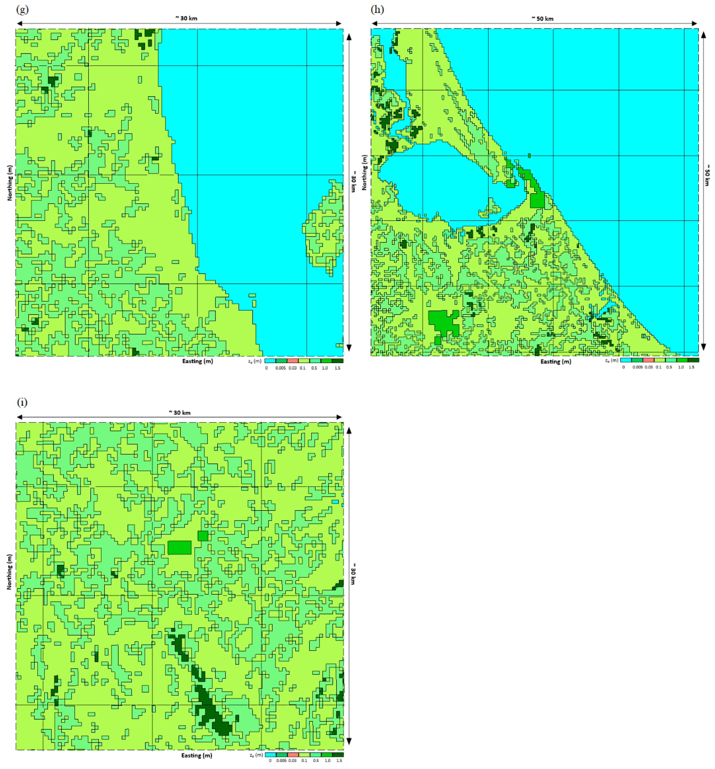
Figure 6 illustrates the monthly average wind speed at 10 m (AGL) for the 3-year period. The average wind speed is lower in the months from May to October, while it is higher from November to April due to the northeast monsoon that brings cold and dry air from the South China Sea, causing strong winds in the Gulf of Thailand and coastal regions of south–eastern Thailand.
The dominant wind direction has great importance in the evaluation of a wind energy resource [
35]. In order to harness the maximal wind energy, the orientation of the wind generator should be perpendicular to the wind direction [
34].
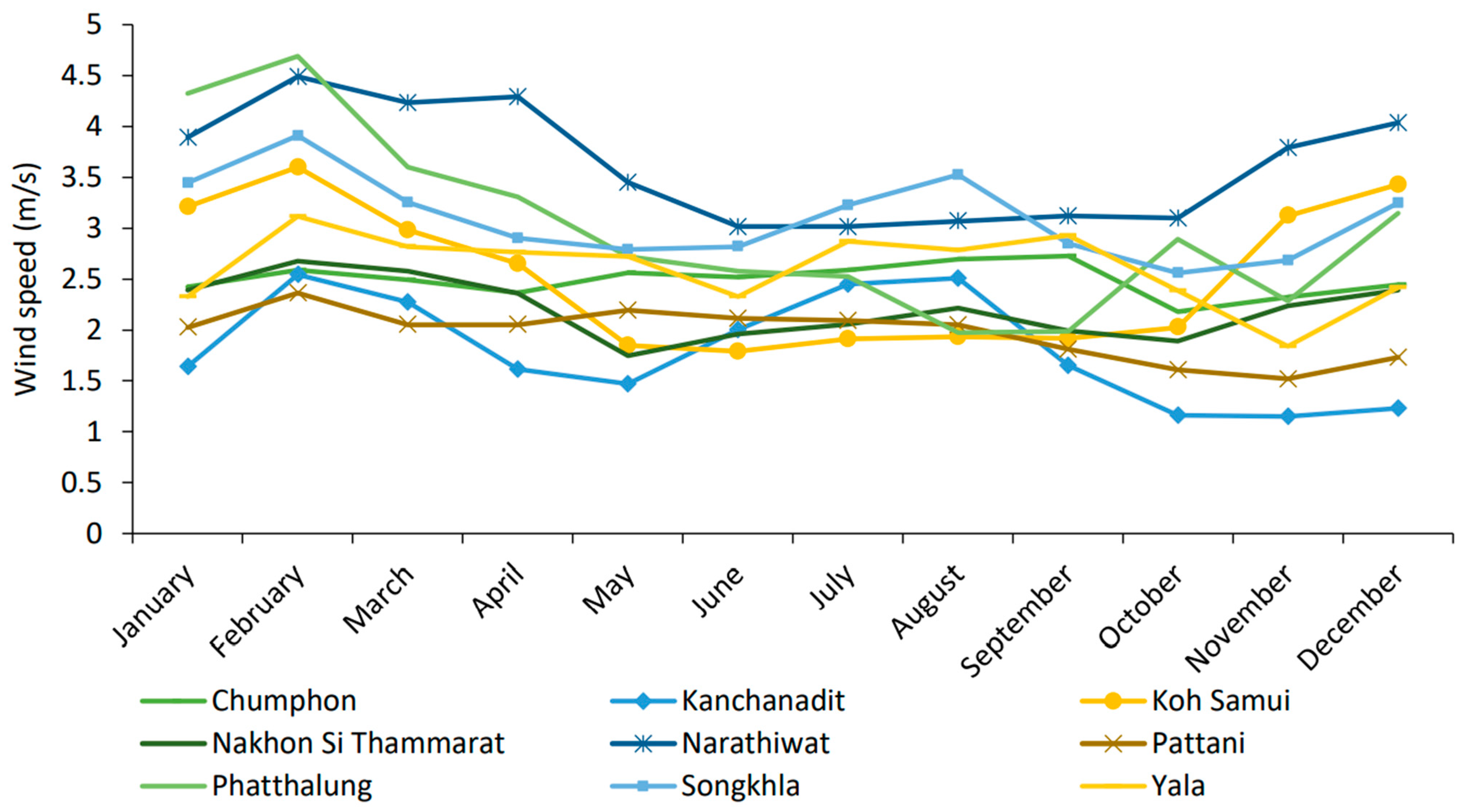
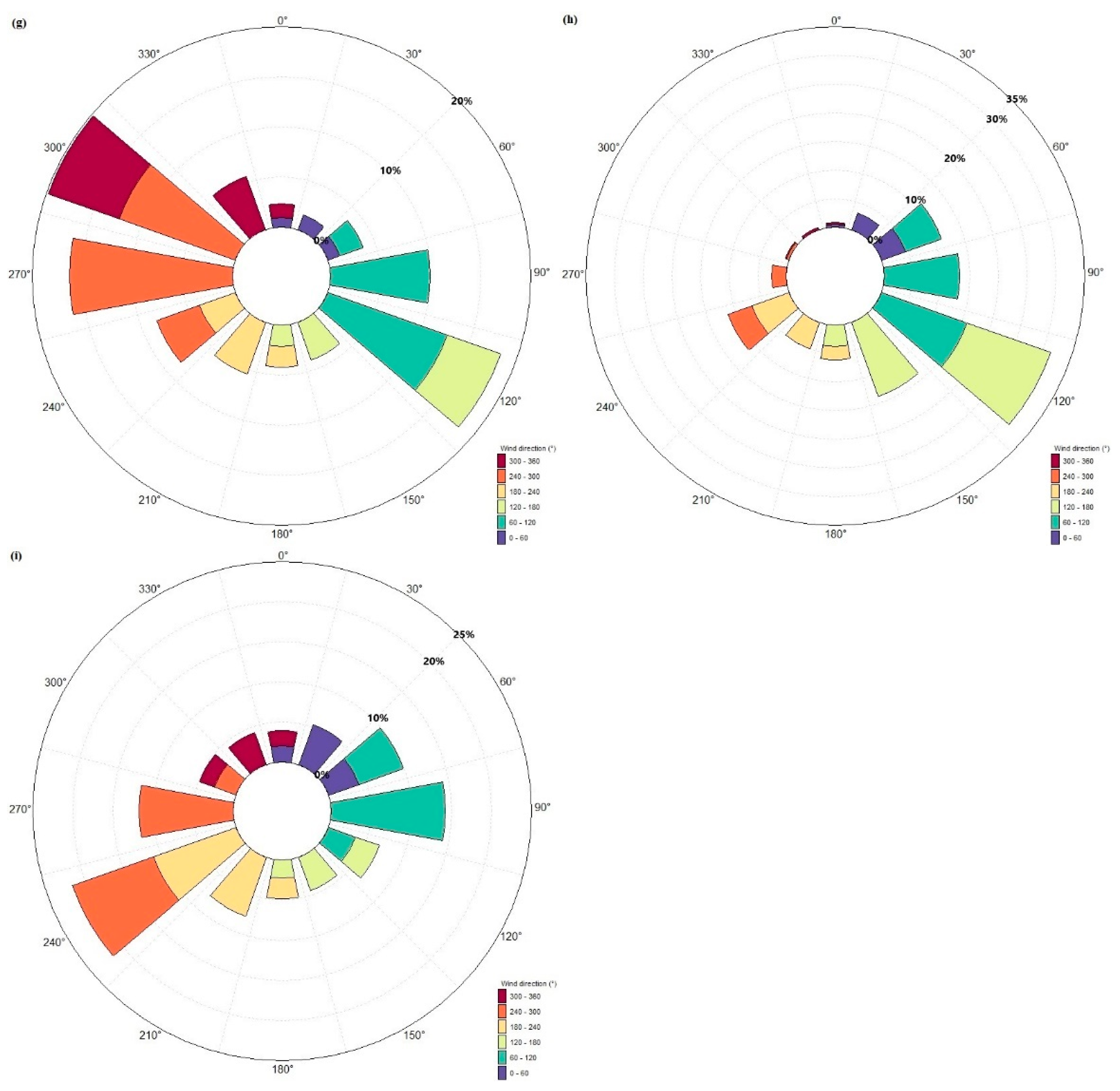
Figure 7, clearly depicts the sector–wise distribution as wind roses for south–eastern Thailand in 12 parts, with discrete 30° intervals.
The wind rose diagrams in
Figure 7 show that the dominant wind direction observed over the three years is northwest in Chumphon and Nakhon Si Thammarat, whereas it is southwest in Narathiwat and Yala. Similarly, the southeast direction is dominant in Kanchanadit, Pattani, and Songkhla. The bi–directional northwest–southeast wind rose is more pronounced in Phatthalung, while west is the dominant direction in Koh Samui. Moreover, the occurrence rate of northwest wind direction for Chumphon and Nakhon Si Thammarat is almost 23%, whereas the occurrence rate of southwest wind for Narathiwat and Yala is about 28% and 22%, respectively. Similarly, the occurrence rate of the southeast direction in Kanchanadit, Pattani, and Songkhla is prevailing with 21%, 18%, and 32%, respectively. The occurrence rate of bi–directional northwest–southeast wind in Phatthalung is almost 24% from the northwest and 23% from the southeast, while the occurrence rate of the west direction in Koh Samui is almost 23%.
Wind power density is the maximum available wind power per unit area and can be expressed as [
25,
49]:
Similarly, the mean wind power density can be measured by using the observed wind data, and is given by [
36]:
where
indicates the mean air density (kg/m
3) of a specific time interval,
is the
th wind speed (m/s), and
is the number of occurrences of
th speed (frequency).
The wind power density can be divided into seven categories on the basis of wind speed and annual wind power density, as shown in
Table 4 [
25,
50].
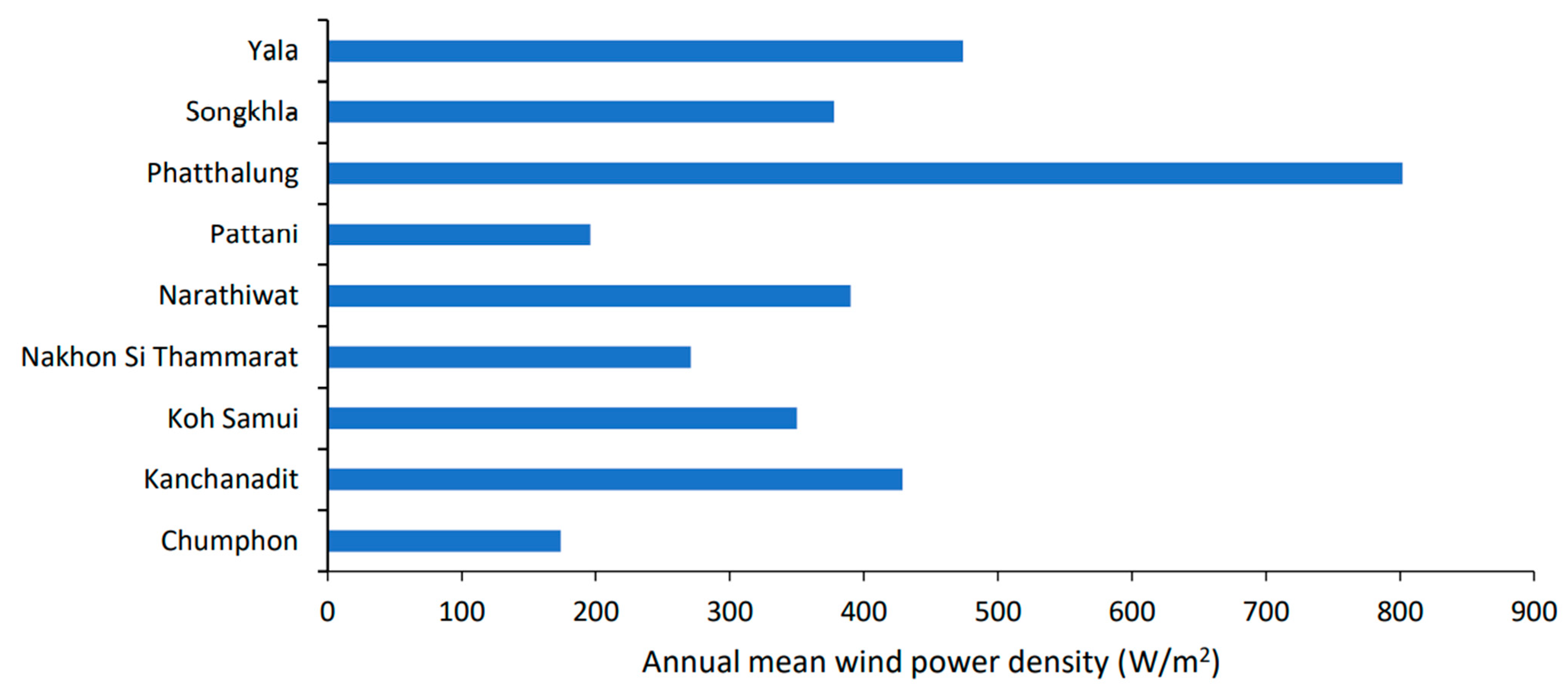
Figure 8 represents the annual mean wind power density in south–eastern Thailand at a 28.5 m hub height. The wind energy resource in south–eastern Thailand varies from station to station as shown in
Table 3. For south–eastern Thailand, the annual mean wind power density with the highest value of 802 W/m
2 was found in Phatthalung, which belongs to wind class 7, followed by Yala with 474 W/m
2 and Kanchanadit with 429 W/m
2, and both these stations fall in wind class 4. The minimum annual mean wind power density of 174 W/m
2 was recorded in Chumphon, followed in increasing order by Pattani with 196 W/m
2, and both stations belong to wind class 1; while Nakhon Si Thammarat with 271 W/m
2 falls in wind class 2. Similarly, Narathiwat, Songkhla, and Koh Samui were at 390 W/m
2, 378 W/m
2, and 350 W/m
2, respectively, belonging to wind class 3.
Yu and Qu [
52] reported that good or excellent potential sites are suitable candidates for establishing a wind energy facility, with wind power density exceeding 400 W/m
2 or even reaching 800 W/m
2, and wind speed on average is above 7.0 m/s. Thus, the various sites in south–eastern Thailand inspected using WAsP possess very good potential for wind farm development.
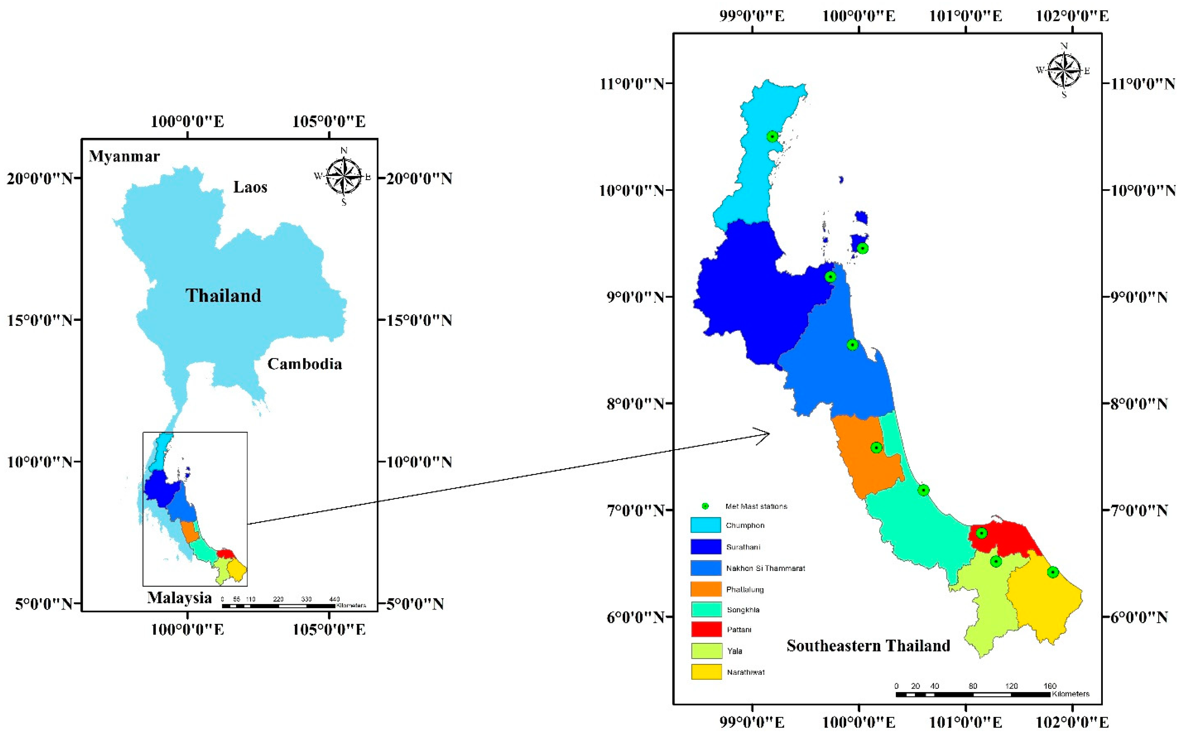
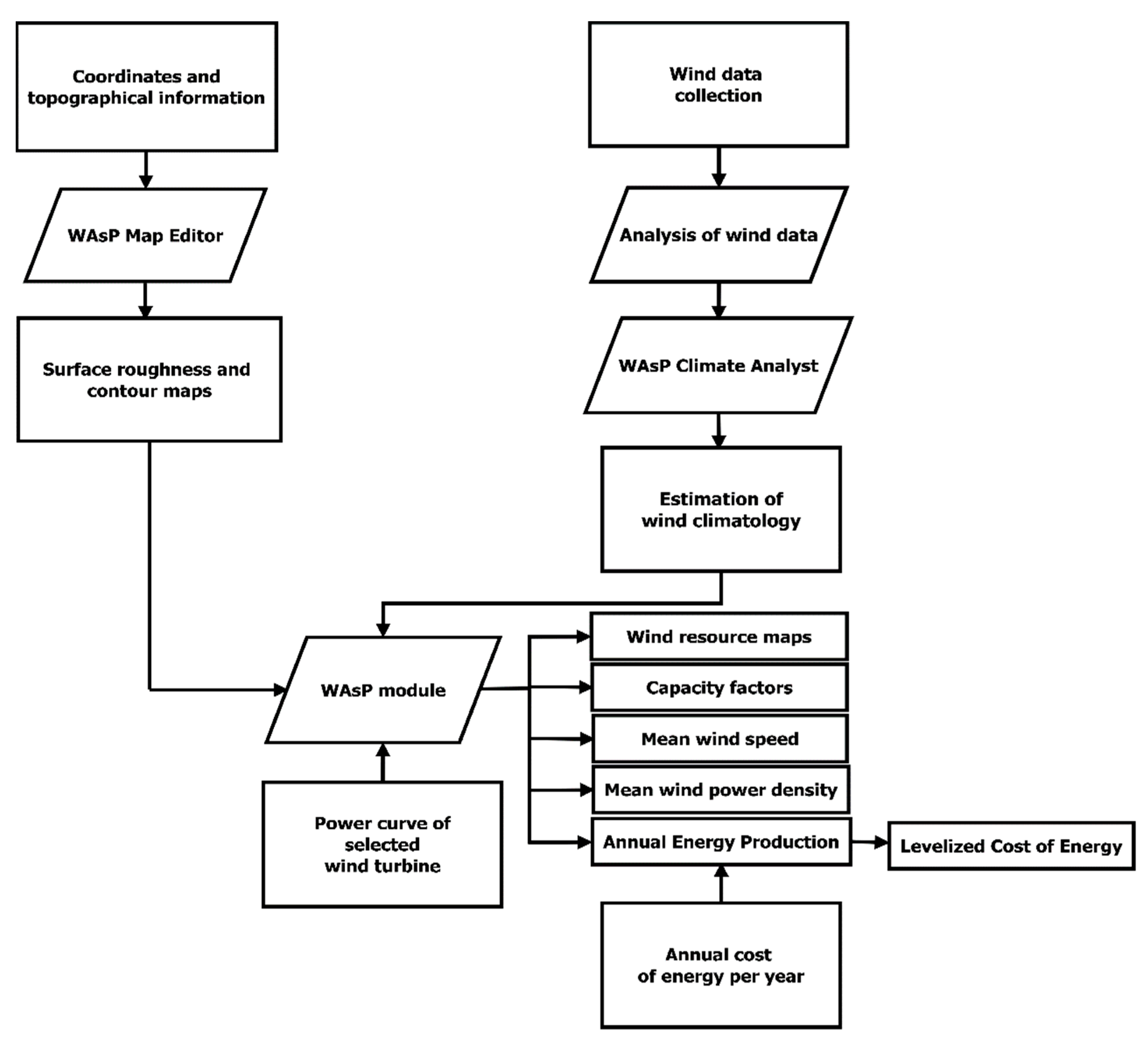
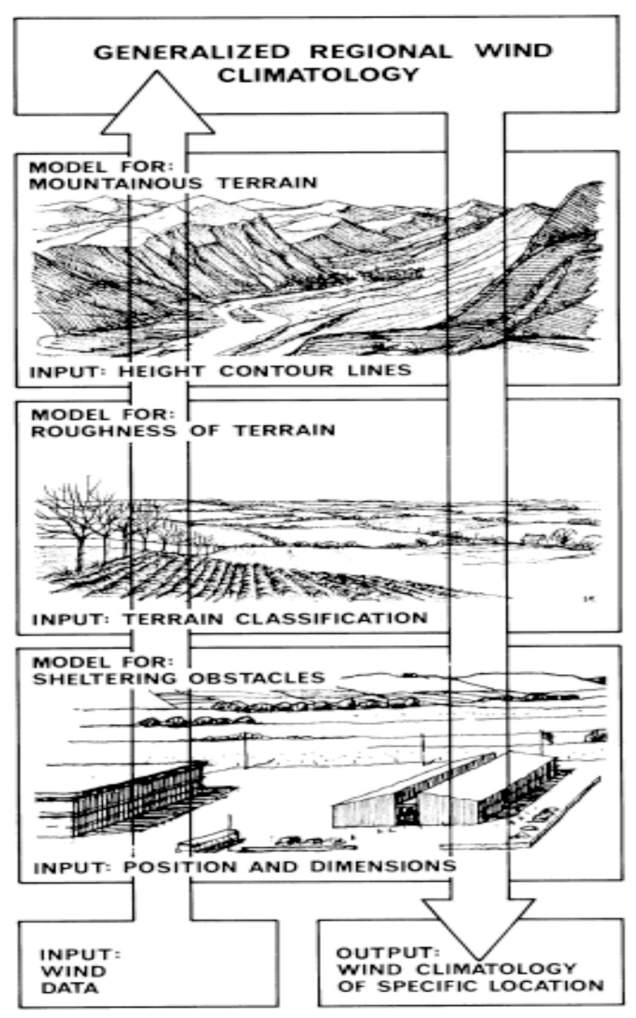
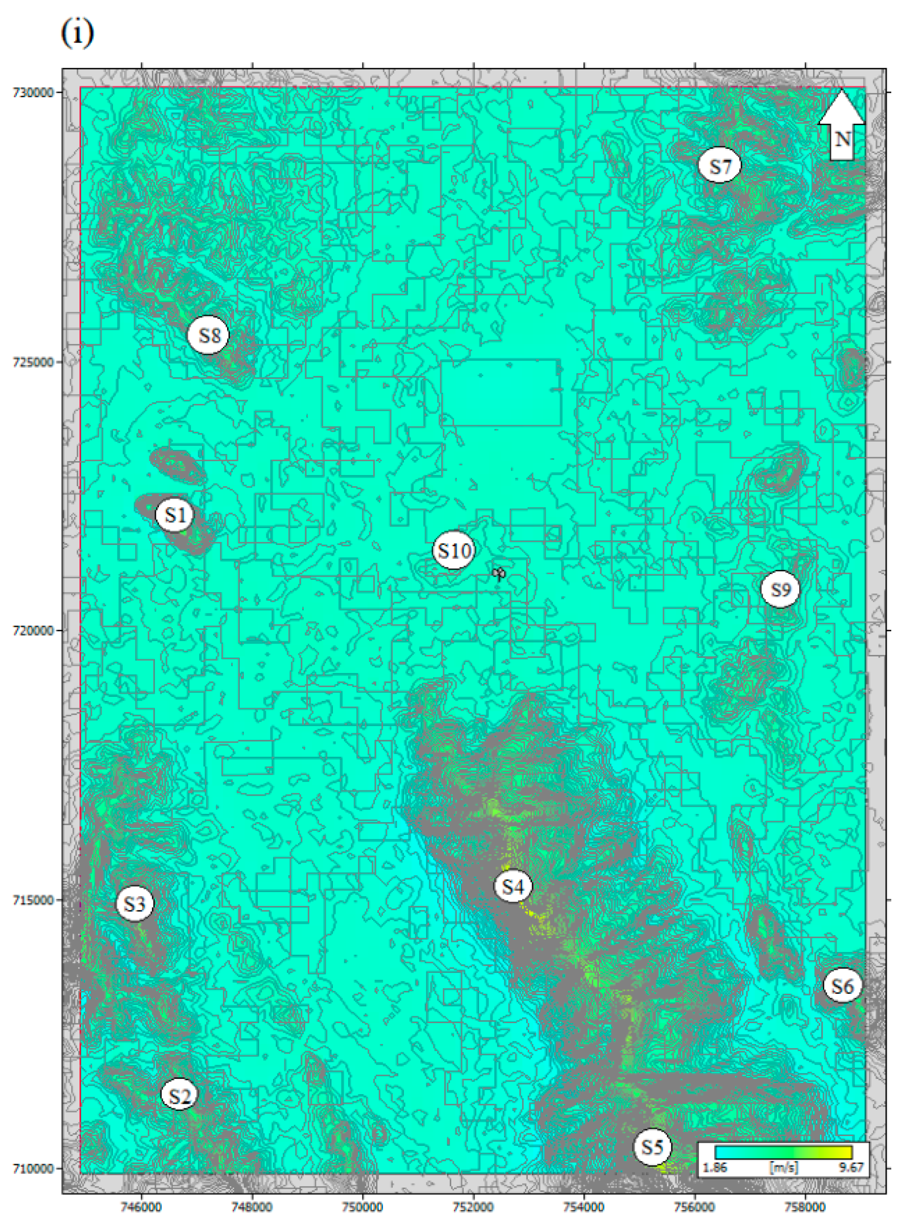
3.2. WAsP Analysis: South–Eastern Thailand
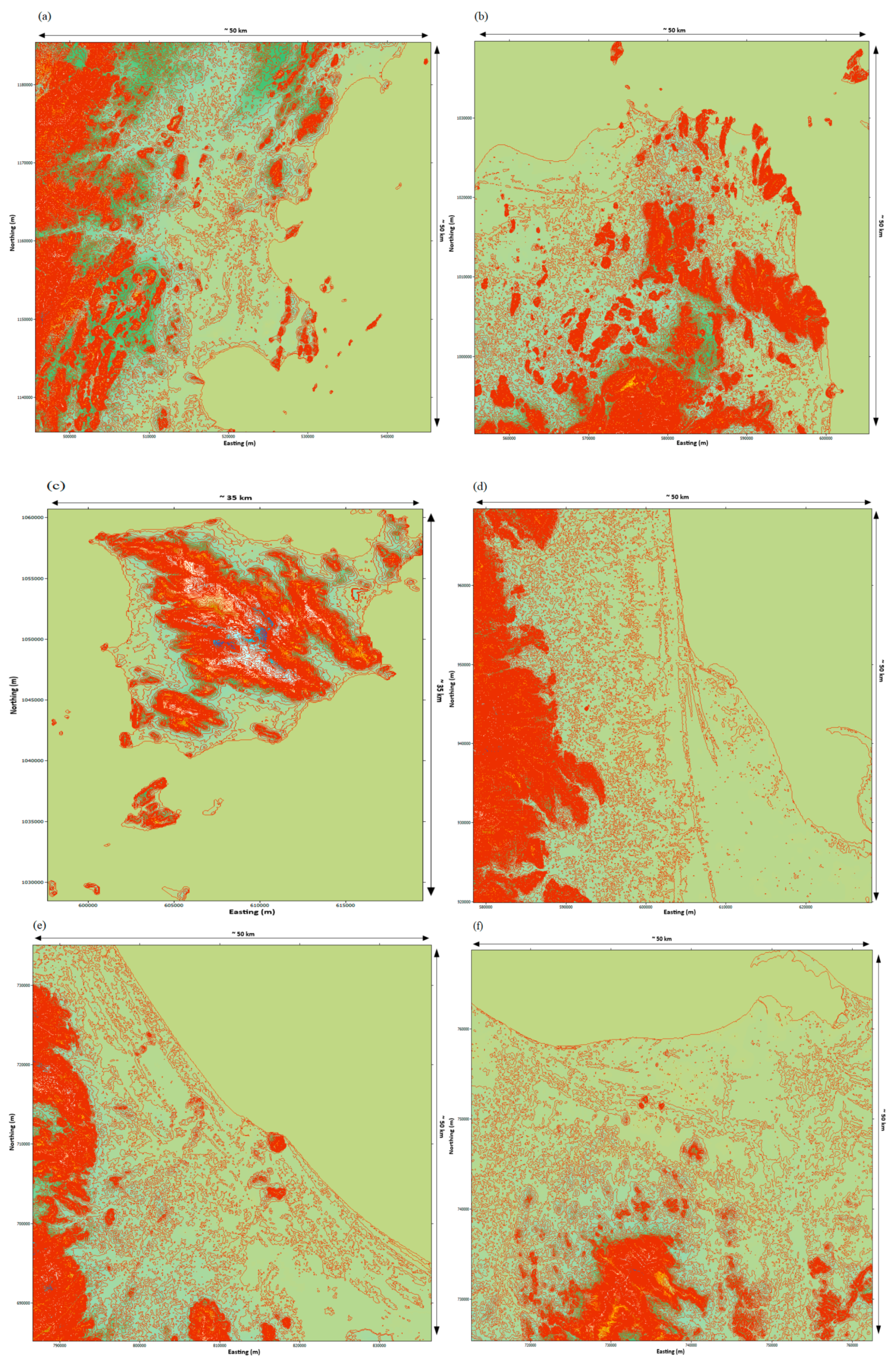
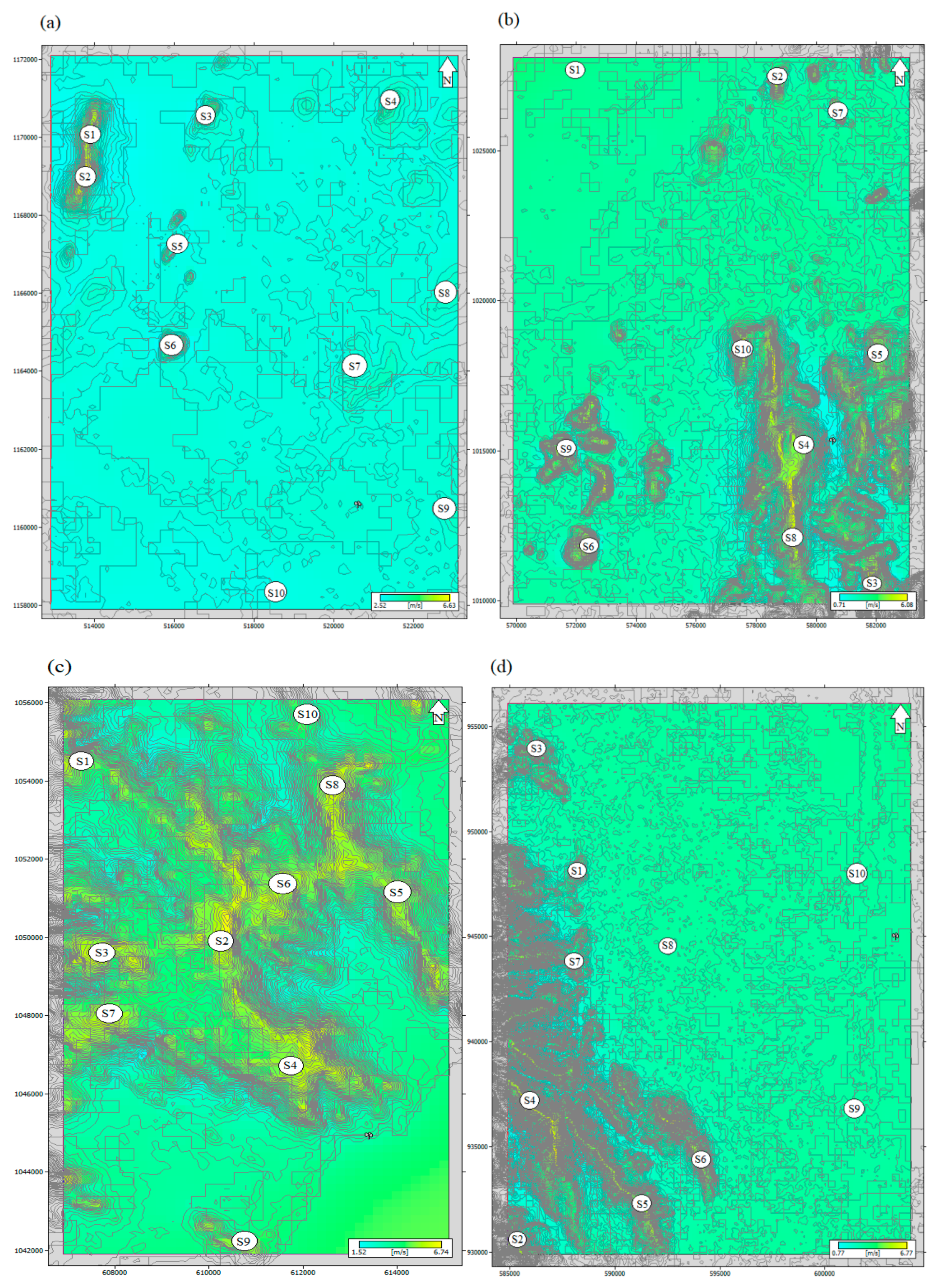
The wind resource maps show the mean wind speed extrapolated for a portion of south–eastern Thailand in
Figure 9. This study identifies ideal sites in the eight provinces of south–eastern Thailand. WAsP analysis was carried out for the thickly populated, increasing infrastructure and remote areas. Nine stations were inspected by analyzing 3 years of wind data for a prospective wind farm facility. In the next stage, a power analysis was conducted for the selected locations in accordance with the mean wind speed, wind power density, accessibility by using roads, and electrical transmission lines [
53].
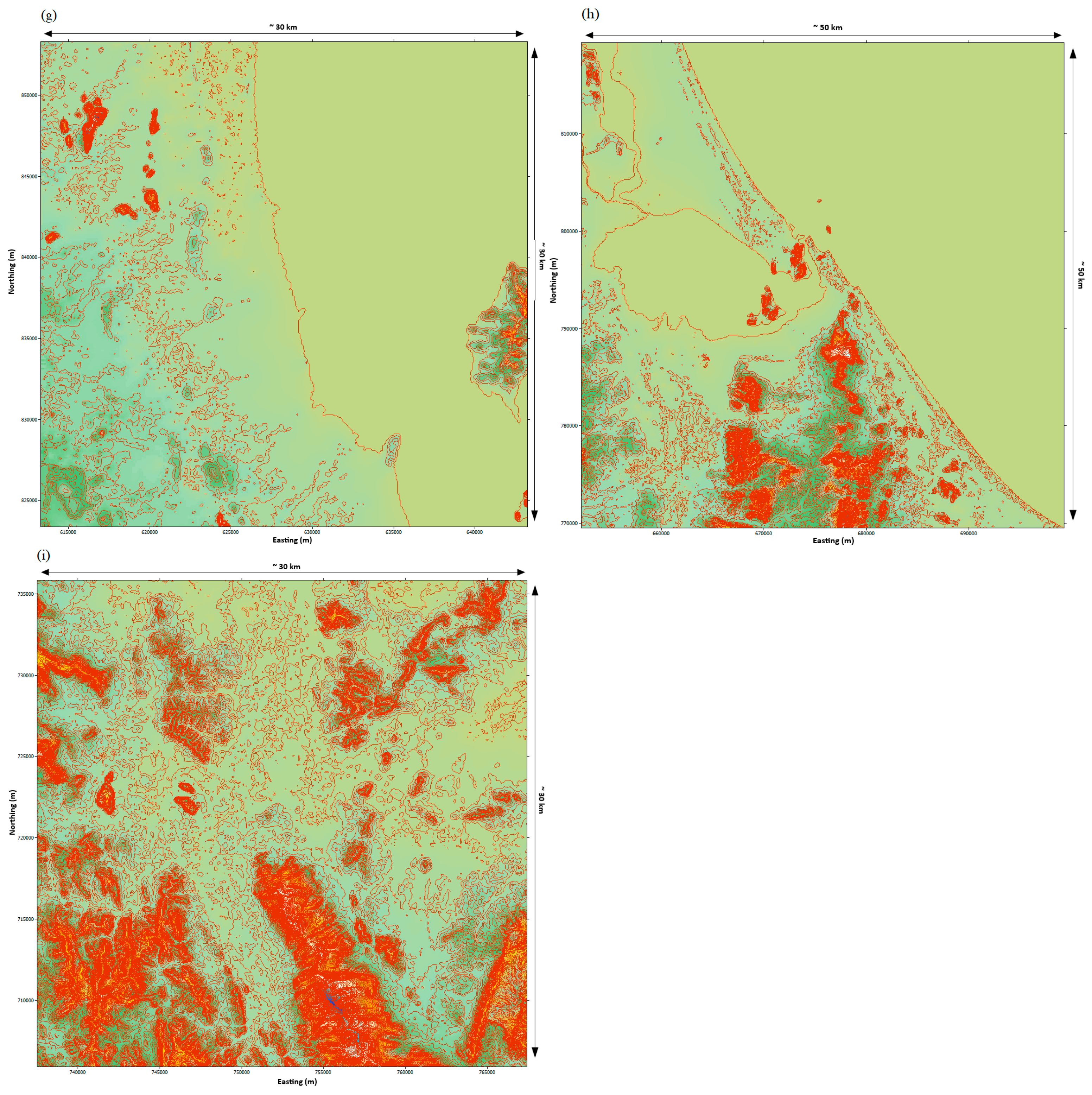
Wind speed highly varies in direction with respect to different locations; thus, those areas encompassed by the resource grid fall within the WAsP’s limits of predictability. Various types of wind turbines can be proposed for the selected sites. However, the wind turbine model for this work is selected on the basis of the availability and reliability of information about the specifications of the power curve. Other types of wind turbine models available in the market may be more appropriate than the one used in this assessment. For instance, there is a wind turbine model that is specifically designed for a low–speed wind regime, but it lacks specifications in the literature. Eight to ten sites in each station of south–eastern Thailand were selected within the resource map plot for power analysis using the wind generator Enercon E–18 with a rated power of 80 kW. These sites were selected based on the mean wind speed, wind power density, accessibility by using roads, and electrical transmission lines.
The 10 m measurement towers installed by the TMD are mounted in relatively exposed areas in south–eastern Thailand. Sites along the ridges, mountain peaks, and coastal ridges show good wind speeds within the resource grid at a 28.5 m hub height.
In south–eastern Thailand, the northern stations such as sites along the northwestern ridges (S1 and S2) in Chumphon and the mountain peaks (S2, S3, and S8) in Kanchanadit, (S2, S3, S6–S9) Koh Samui, and (S2, S4–S6) Nakhon Si Thammarat show good potential for wind farm development with a mean wind speed of 6.0–6.9 m/s, 5.8–6.7 m/s, 6.0–6.7 m/s, and 6.3–6.7, respectively. However, the sites inspected near the coastal side in the south (S10) and east (S7–S9) of Chumphon, northwest (S10) of Kanchanadit, and the eastern part (S9 and S10) of Nakhon Si Thammarat possess less potential for wind farm facility implementation.
In central stations, all sites along the peaks of mountains (S1 to S10) of Songkhla and northwestern ridges (S1, S6, and S8) of Phatthalung in the resource map plot have very good mean wind speeds from 5.9 m/s to 7.1 m/s and from 5.9 m/s to 8.8 m/s, respectively. These sites have very good potential for wind farms in the future. However, in Phatthalung, sites on the leeward side (S5) and plain areas (S4, S9, and S10) towards the Songkhla lake show less potential for a wind park, because of a mean wind speed of about 3.4 m/s to 4.3 m/s.
The resource maps show great potential on the mountain peaks and ridges in the southernmost stations, in Narathiwat and Yala provinces in south–eastern Thailand. All the sites investigated in Narathiwat and Yala have mean wind speeds around 5.1–8.6 m/s and 5.1–9.4 m/s, except site (S10) close to the meteorological station in Yala, which has very little potential (4.2 m/s). Sites inspected along the ridges (S8 and S5) and towards the northern (S9) and eastern (S10) coast in Narathiwat possess good mean wind speeds of about 5.3 m/s to 8.6 m/s, because of their proximity to the shore. Further investigation regarding offshore wind speed is required around the coastal regions of Narathiwat, which can be expected to have great potential for offshore wind farm facilities in the future. On the other hand, regions (S1, S4–S10) examined on ridges in the Pattani province had less potential for a wind farm facility. However, from the resource, it is apparent that the sites on mountain peaks in the southwest (S2) and south (S3) show some potential for wind farm development as these sites have a mean wind speed of about 5.1 to 6.9 m/s.
The area of south–eastern Thailand is fairly smooth. Regions on the leeward side and plain areas in south–eastern Thailand have much less potential for a wind farm facility, as they are surrounded by many artificial obstacles, for instance high–rise buildings and urban infrastructure, which make airflow highly turbulent and may affect the wind flow. However, mountain peaks and ridges show great potential for a prospective wind farm facility, which are generally located far from the power grid. Hence, small–scale wind turbines can act as a useful power source in such locations [
54].
The average power generated by a wind turbine can be computed by applying the following equation:
where
shows the output power, which is defined by the turbine power curve.
Moreover, the energy yield from a wind turbine can be calculated as:
where
is the wind speed, which is averaged over a time interval
, and N is the number of recorded observations.
The Enercon E–18 wind turbine with a rated of 80 kW was used in the power analyses of the identified potential sites. Technical specifications of the turbine are shown in
Table 5. The cut–in and cut–out speeds of the Enercon E–18 wind turbine rotor are 2.5 m/s and 25.0 m/s, respectively.
The wind turbine power curve and a site’s wind characteristics can be used to estimate the future energy generation over a specific period [
35].
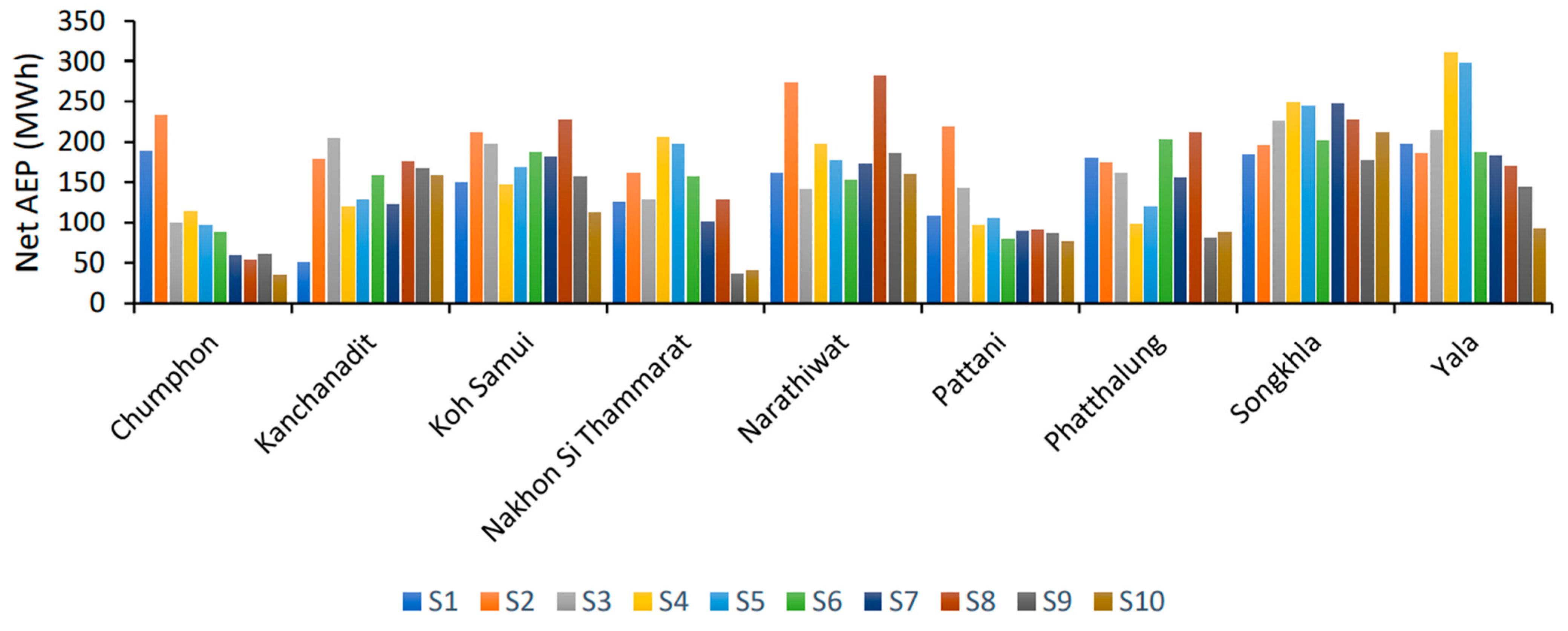
Figure 10 shows the net AEP at the selected sites in each station of south–eastern Thailand. Based on the average net AEP generated by WAsP, Songkhla has the highest potential for prospective wind energy development, followed by Yala and Narathiwat in south–eastern Thailand.
In northern stations, the average net AEP for Chumphon, Kanchanadit, Koh Samui, and Nakhon Si Thammarat is about 102 MWh, 146 MWh, 173 MWh, and 127 MWh, respectively. In Koh Samui, sites (S2, S3, S6–S8) inspected by WAsP have great potential for a wind farm facility with a net AEP of about 180 MWh to 226 MWh. As mentioned previously, Koh Samui is an island and a famous tourist point. Hence, it is linked by an underwater cable to the mainland power plant in Surat Thani. An array of 10 or more 80 kW small–scale wind turbines integrated with other renewables, such as solar, can be used for generating electricity for Koh Samui Island. Furthermore, certain sites in Kanchanadit (S2, S3, and S8), Nakhon Si Thammarat (S4 and S5), and Chumphon (S1 and S2) show a net AEP of about 175 to 204 MWh, 197 to 205 MWh, and 188 to 232 MWh, respectively. These sites have great potential for prospective wind farm facility development.
In central stations, Songkhla and Phatthalung show an average net AEP of about 216 MWh and 146 MWh, respectively. All the sites (S1 to S10) inspected by WAsP in Songkhla show great potential for a prospective wind farm facility with a net AEP of around 177 to 250 MWh, whereas certain sites (S1, S2, S6, and S8) in Phatthalung along the ridges in the northwest display a net AEP around 173 to 211 MWh, and also have very good potential for prospective wind farms.
In the southernmost stations, Yala, Narathiwat, and Pattani depict an average net AEP of about 198 MWh, 190 MWh, and 109 MWh, respectively. Sites along the ridges and mountainous areas in Yala (S1–S6) and Narathiwat (S2, S4, S8, and S9) possess a net AEP around 186 to 311 MWh and 197 to 282 MWh, respectively. These sites show the highest potential for prospective wind farm development. Furthermore, Pattani has only one site (S2) on a mountain peak with a net AEP around 218 MWh, and this site is expected to have good potential for wind farm development in the future.
South–eastern Thailand has a population of more than 7.1 million. It is one of the highest power–consuming regions in Thailand and receives many tourists throughout the year due to popular destinations such as Koh Samui, Koh Pha Ngan, and Koh Tao. As reported by the Electricity Generating Authority Thailand, power demand has been increasing by 5 to 6% in southern Thailand annually, due to the development of services and tourism. Hence, the prospective sites scrutinized by WAsP could reduce the burden on the local power distribution stations and would be sufficient to meet the rising power demand in south–eastern Thailand.
Meanwhile, the capacity factor
of the wind turbine is defined as the dimensionless ratio of the average power output
and the rated power output
over a certain period of time (usually over one year) and can be expressed as [
55,
56]:
where
,
, and
are the cut–in wind speed, cut–out wind speed, and rated wind speed, respectively. Similarly,
signifies the Weibull scale parameter and
is the dimensionless Weibull shape parameter. Then, the average power output
can be expressed as:
Once the value of the average power output
is known, the average gross energy production
of a wind turbine can be estimated for a specific duration as:
Moreover, , where and represent the time span in hours and in days, respectively.
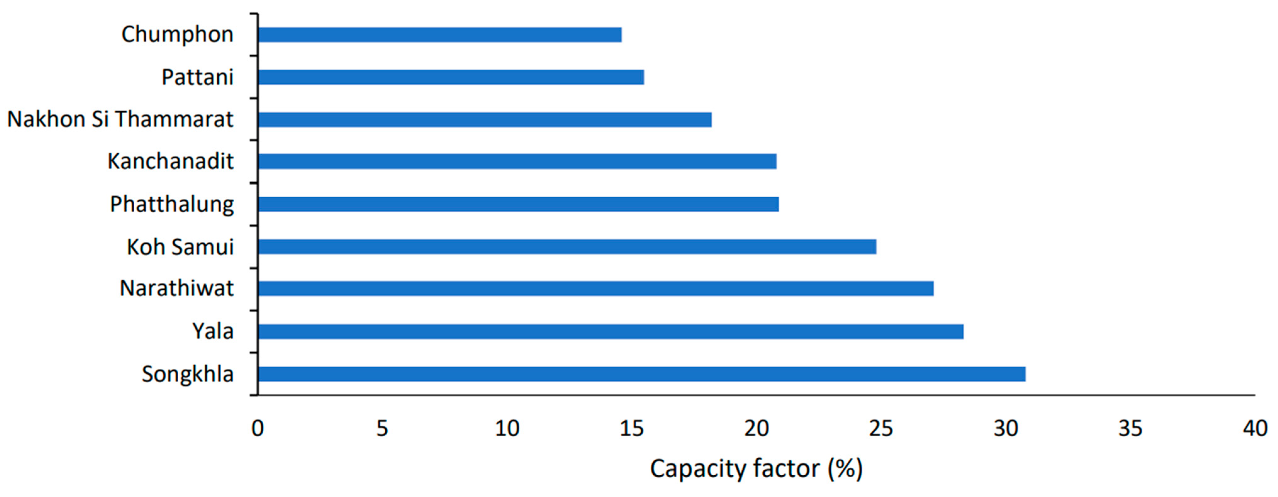
The capacity factor mainly depends on the wind resources and wind turbine technology. An annual capacity factor of 17% or greater is considered desirable for wind power [
25]. This study computed the annual capacity factors of the nine stations in south–eastern Thailand at the 28.5 m hub height using the WAsP program. The results show that Songkhla, Yala, and Narathiwat have annual capacity factors of 27% or over. Koh Samui, Phatthalung, and Kanchanadit have annual capacity factors ranging between 20% and 25%, whereas Nakhon Si Thammarat, Pattani, and Chumphon have annual capacity factors of 18%, 16%, and 15%, respectively (
Figure 11).


