Article

Clarifying the Smokescreen of Russian Protected Areas

by
Roberto Cazzolla Gatti
1,2,*,
Alena Velichevksaya
1 and
Luigi Simeone
3
1
Biological Institute, Tomsk State University, 634050 Tomsk, Russia
2
Department of Biological, Geological and Environmental Sciences, University of Bologna, 40126 Bologna, Italy
3
Geospatial Unit, Land and Water Division, Food and Agriculture Organization (FAO), 00153 Rome, Italy
*
Author to whom correspondence should be addressed.
Sustainability 2021, 13(24), 13774; https://doi.org/10.3390/su132413774
Submission received: 5 November 2021 / Revised: 25 November 2021 / Accepted: 10 December 2021 / Published: 14 December 2021
(This article belongs to the Special Issue Sustainability in Conservation Biology)

Abstract

:
Although in strictly protected areas no forest management and logging activities should be evident, a preliminary study detected that, even in the 200 areas with the highest protection of Russia, more than 2 Mha of trees have been lost between 2001 and 2018. Nonetheless, a relevant percentage of the actual drivers of tree loss in Russian strictly protected areas was surrounded by uncertainties due to several factors. Here, in an attempt to “clarify the smokescreen of Russian protected areas”, by validating previous remotely sensed data with new high-resolution satellite imagery and aerial images of land-use change, we shed more light on what has happened during the last 20 years. We used the same layer of tree loss from 2001 to 2020 but, instead of intersecting it with the MODIS data that could have been a source of underestimation of burned surfaces, we overlapped it to the layer of tree cover loss by dominant driver. We analysed the main drivers of tree loss in almost 200 strictly protected areas of Russia. We found that although fire is responsible for 75% of the loss in all strictly protected areas, forestry activities still account for 16%, and 9% is due to undefined causes. Therefore, uncontrolled wildfires (including those started before or after logging) and forestry activities are the main causes of 91% of the total tree loss. The combination of wildfires (often started intentionally) and forestry activities (illegally or barely legally put in place) caused a loss of an astonishing 3 million hectares. The fact that ≈10% of Russian tree cover was lost in two decades since 2001 only in strictly protected areas requires high attention by policymakers and important conservation actions to avoid losing other fundamental habitats and species during the next years when climate change and population growth can represent an additional trigger of an already dramatic situation. We call for an urgent response by national and local authorities that should start actively fighting wildfires, arsonists, and loggers even in inhabited remote areas and particularly in those included in strictly protected areas.

1. Introduction

Russian forests play a crucial role for the climate, representing an important carbon stock, and although they are relatively poor in tree diversity, these ecosystems are fundamental for hosting several species, including rare ones, and also provide socio-economic benefits to indigenous people [1]. Nonetheless, during the last years, large areas of Russian forests have been lost mainly because of wildfires and forestry activities [2]. A recent study [3] estimated that from 2001 to 2018, in the whole Russian Federation territory, 66 Mha of tree cover have been lost (≈7.5% decrease in tree cover since 2001) with peaks during recent years. To prevent this huge loss, much emphasis was put by the local authorities on Protected Areas as a fundamental way to conserve Russian wildlife [4]. Despite this, there is emerging evidence that even in strictly protected areas, the intensity of forest fires and other tree losses in Russia, which can mainly be associated with logging, is not decreasing and has reached its unprecedented size and strength in recent years [5], when the burning and loss of millions of hectares has contributed significantly to climate change [6] and threatens biodiversity [7]. Although in strictly protected areas no forest management and logging activities should be evident, it was detected that even in the 200 areas with the highest protection of Russia, more than 2 Mha of trees have been lost between 2001 and 2018 [3]. Together with an overall (in the whole country) forest loss of 70% caused by fires and 30% by forestry management, there was evidence that even in strictly protected areas the contribution of “other-than-fire” losses was significant, even if its actual drivers were surrounded by uncertainties due to several factors [3].
Most national parks and World Heritage Sites of Russia, despite the uniqueness of their nature, are quite recent: They began to be created only in the 1980s. Now, their number is increasing every year following the general rule to “exist untouched” by human activities. Of them, 40 Russian Pas have the status of a World Heritage Site, including 13 state nature reserves, 7 state natural national parks, 4 nature reserves of federal significance, 7 nature parks, 6 nature reserves of regional significance, and 3 natural monuments of regional significance [8]. These areas include the famous areas of Virgin Komi forests, Lake Baikal, Volcanoes of Kamchatka, Golden Mountains of Altai, etc. Therefore, the evidence of disturbances that diminished tree and forest cover in strictly protected areas of Russia was quite unexpected.
The study by Cazzolla Gatti et al. (2021) addressed the challenging task of identifying, within the total forest loss of protected areas, the surface affected by fire, under the hypothesis that forest loss is equal to or larger than burned areas, whereas other causes may determine forest loss. To reach this goal, the information reported in the compared data should match in time and space. This left most of the “other-than-fire” surface without a defined driver, even if forestry management was identified as the most likely one. However, as mentioned in Section 4.2 (pages 8–9) of Cazzolla Gatti et al. (2021), these uncertainties can be first related to the missed detection by the satellite MODIS MCD64A1 and MODIS FireCCI51 of burned areas. Moreover, specifically for LANDSAT data, the study mentions that “Some further uncertainties can be also related to Landsat data sources. Especially in certain periods, such as in 2001, when the number of cloud-free images is small, some changes that happen in a specific year could be detected and attributed to another year. This can create a mismatch on an annual basis in the comparison between the estimated forest loss from Landsat and the burned areas from MODIS”. In fact, it may happen that the forest loss occurred in one year—because of the presence of clouds or other factors—are reported in the following year. This mismatch between MODIS and LANDSAT can result in a missed reporting of areas affected by fire because the burned areas are not evidenced within the forest loss. An example is what happened in 2015. Several fires determined forest loss, but in the LANDSAT forest loss layer, these are reported only in 2016. Therefore, in 2015, a reduced tree loss is reported. Consequently, in the comparison with MODIS MCD64A1 and MODIS FireCCI51, the areas affected by the fire resulted smaller than the real extent.
Here, in an attempt to “clarify the smokescreen of Russian protected areas”, by validating previous remotely sensed data with new high-resolution satellite imagery and aerial images of land-use change, we shed more light on what has happened from 2001 to 2020 in the Russian Strictly Protected Areas (hereafter, Strict PAs) most affected by forest loss and on what Cazzolla Gatti et al. (2021) initially classified as uncertain drivers.

2. Material and Methods

We used the same layer of tree loss (selecting the areas with forest cover in 2000 > 30% only) from 2001 to 2020 (the LANDSAT products derived with the method proposed by [9] and following updates; Figure 1A), but instead of intersecting it with the MODIS MCD64A1 and MODIS FireCCI51 data that could have been a source of underestimation of burned surfaces, we overlapped it to the layer of tree cover loss by dominant driver (provided by [10]; Figure 1B). GIS analysis was conducted with a licensed ESRI® ArcMap10.8 software. With the GIS software, the following procedure was implemented (Supplementary Figure S1). Input data were “Tree Cover Loss by Dominant Driver” dataset (0.0964 decimal degrees spatial resolution), “Tree cover loss” dataset (1-arcsecond spatial resolution), and List of Parks (protectedplanet.org) joined to the park polygons shapefile. The dataset “Tree Cover Loss by Dominant Driver” was converted into an “int” dataset. The “Int” dataset was converted in polygon format while maintaining the attributes of the classes, the geometry, size, and extension of the original data. The “Tree cover loss” dataset was split into smaller parts and then converted to a polygon format. Geometry, size, and extension of the original data were maintained. A spatial intersection of the (a) “tree cover loss” polygon, (b) “Tree Cover Loss by Dominant Driver” polygon, and (c) the park polygons previously joined with the list of parks was performed. The output of the intersection was a dataset with each record of “tree cover loss” pixel to have the spatially corresponding pixel of the “Tree Cover Loss by Dominant Driver” and the name and ID of each park. Almost 3 million records were generated by the intersection. The projection of the intersected dataset and computation of areas were converted into metric units.
We started considering the special case of Lake Baikal, which ranked first in Cazzolla Gatti et al. (2021) in terms of forest loss. This World Heritage Site, established in 1996, according to the LANDSAT-MODIS year-by-year analysis, suffered a high loss due mainly to fire in 2003, 2011, and 2013 but an even higher tree loss due to other causes in 2004, 2008, 2016, and 2017. The year 2016, as for most of the strictly protected areas (in [3]), represented the highest peak of deforestation not only driven by fire for this protected area. The analysis showed that, from 2001 to 2018, Lake Baikal World Heritage Site may have lost 79% of its canopy cover mainly because of other uncertain causes, which could not be detected by MODIS MCD64A1 and MODIS FireCCI51 sensors. However, reminding that in summer 2015 Lake Baikal and other regions of Siberia suffered huge wildfires, we were then surprised to do not see this fire loss reflected in the statistics of that year. Therefore, we used a different analytic approach to understand whether this bias could be the result of the fact that some changes that happen in a specific year could be detected and attributed to another year, and this can create a mismatch on an annual basis in the comparison between the estimated forest loss from Landsat and the burned areas from MODIS, as mentioned by Cazzolla Gatti et al. (2021). This approach allowed us to clarify the uncertainties on the factors that may have caused forest loss in the areas classified as “other (?) loss” in Cazzolla Gatti et al. (2021). We found that although wildfires are still relevant and account for 66% of the forest loss, forestry activities (which, in a strictly protected area and a World Heritage Site, are unexpected) are responsible for 33% of the tree cover loss (Figure 1C). An annual basis analysis of the loss by driver showed that wildfires (undetected by MODIS) took about 50% of the whole forest loss, but even in years of huge wildfires (e.g., 2015 and 2016), forestry activities were still relevant (e.g., in 2015, ≈22%; Figure 1D).
As additional validation of this approach, we randomly selected some areas with forest loss driven by logging (green areas, circled in red, within PA’s borders in Figure 1B) and analysed the georeferenced Landsat imagery looking for signs of land-use change (between 2001 and 2018) and, in particular, of forestry activities with 2021 Maxar aerial photos (Figure 2). This further analysis confirmed that the layer of tree loss by dominant driver [10] correctly identifies areas with actual forestry/logging activities.
Assessing the reliability of this approach, we extended the analysis to all the Strict PAs of Russia, with a focus on the protected areas that experienced a tree loss >10,000 ha from 2001 to 2020.

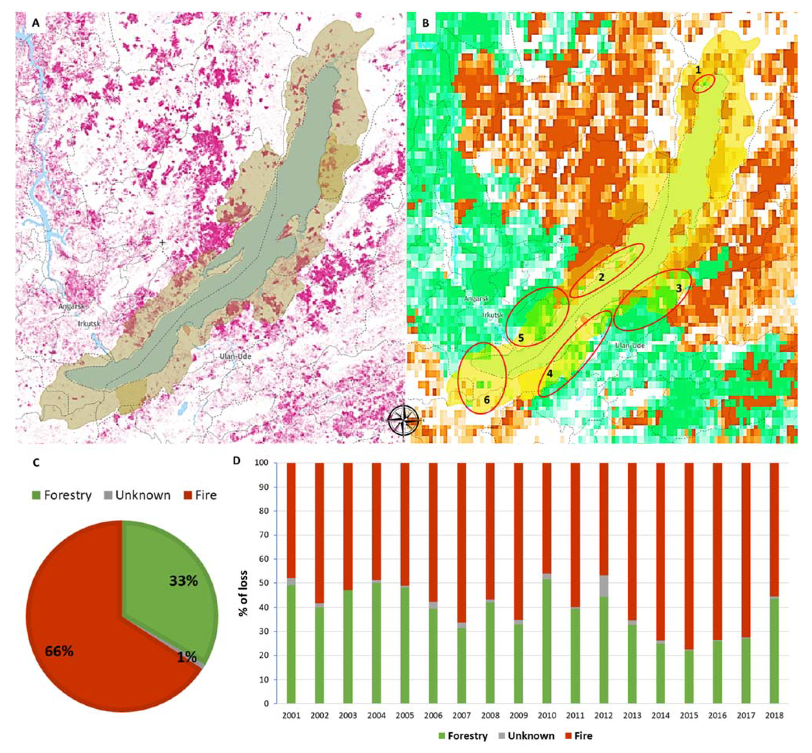
3. Results and Discussion

Following the abovementioned procedure, we analysed the main drivers of tree loss in almost 200 strict protected areas of Russia from 2001 to 2020 (Supplementary Table S1).
The total tree loss in the strictly protected areas of Russia from 2001 to 2020 was impressive with 2,987,594.38 ha lost, of which 267,978.87 ha was due to undefined causes, only 552.35 ha due to land-change to develop agriculture, 488,490.51 ha because of forestry activities, 2,229,539.93 ha due to wildfires, and just 1032.71 ha due to urbanization (Supplementary Table S1). Therefore, agriculture and urbanization were minor drivers of tree loss, whereas wildfires and forestry represented the main causes.
We found that although fire is responsible for 75% of the loss in all strict PAs, forestry activities still account for 16%, and 9% is due to undefined causes (Figure 3). Among the strictly PAs, most affected by tree loss due to forestry, fire represented the main driver only for the Lake Baikal World Heritage and the Kama-Bakaldino mires. Lake Baikal PA ranks first also among Strict PAs most affected by fire (Figure 3).
From an unprecedented long-time series analysis of satellite imagery [3], it was detected that, in the areas with the highest protection of Russia, fire certainly contributed at least ≈25% to the loss of more than 2 Mha between 2001 and 2018, but “undefined” causes represented the major driver. It was suggested that illegal forestry activities may be considered important sources of tree loss in Russian Strict PAs because legal logging is not allowed in these categories of conservation zones. It was, thus, assumed that a relevant part of the tree loss not due to fire may be related to illegal logging/deforestation. However, at the state of that preliminary study, there was no information to understand the real causes of tree loss, and this part was indicated with a question mark, as “other (?) losses” [3].
Now, with a more detailed analysis of the main drivers of tree loss in Russian Strict PAs, we can confirm with higher confidence that uncontrolled fires exert a relevant role in reducing tree cover even in protected areas, but forestry activities are still the second main and relevant driver.
The problem of uncontrolled wildfires that threaten even Strict PAs does not seem a concern of local authorities because most of them burn remote areas where authorities are not obliged to take action [11]. Nonetheless, Russian prosecutors confirmed that some of the enormous wildfires that burned Siberian forests in the last years were started deliberately by arsonists trying to conceal illegal logging activity [12]. For instance, the general prosecutor said it had identified cases in which forest fires in the Irkutsk region of Siberia were caused for illegal wood felling [12]. Therefore, it is very likely that a significant percentage of tree loss due to fire, started for illegal logging [13], should be added to the 15% we identified as a certain cause of the loss in Strict PAs. In any case, uncontrolled wildfires (including those started before or after illegal or barely legal logging) and forestry activities are the main causes of 91% of the total tree loss in Russian Strict PAs.
Among the 39 strict protected areas that experienced a tree loss >10,000 ha, 38 had wildfires as the main driver, 20 show forestry as the second main driver, and 1 Strict PAs, Oka and Pra River Floodplains (a Ramsar Site and a Wetland of International Importance), was even not subject to any fire but experienced impacting forestry activities (Table 1).
From 2001 to 2020, we found that Lake Baikal World Heritage Site suffered a tree loss of ≈177 k ha due to forestry (which is almost half of the loss due to fire) followed by consistent losses caused by forestry activities in Sibirskie Uvaly Nature Park (≈66 k ha), Sikhote-Alin UNESCO-MAB Biosphere Reserve (≈40 k ha), Kama-Bakaldino mires Ramsar Site and Wetland of International Importance (≈24 k ha), Botchinsky Zapovednik (≈19 k ha), Oka and Pra River Floodplains Ramsar Site and Wetland of International Importance (≈16 k ha), Meschera National Park (≈14 k ha), Nerusso-Desnianskoe-Polesie UNESCO-MAB Biosphere Reserve (≈12 k ha), Sayano-Shushenskiy UNESCO-MAB Biosphere Reserve (9 k ha), Mordovsky Zapovednik (≈8 k ha), and Central Sikhote-Alin World Heritage Site (≈6 k ha) (Table 1).
What clearly emerges from the detailed analysis of the Russian Strict PAs that experienced a tree loss >10,000 ha between 2001 and 2020 is that agriculture and urbanization played no role in removing forest cover, whereas forestry heavily added its contribution to the huge loss caused by wildfires. These findings clarify the previous preliminary evidence [3], adding more clues and information to the undefined causes of forest loss in Russian strictly protected areas (particularly on the role of wildfires and logging) and are supported by recent alarming reports on the increase in Siberian fires [14] and allegations against local Russian administrators who favoured illegal logging in protected areas [15]. Moreover, in almost all Strict PAs, we show a, sometimes relevant, tree loss due to unidentified causes that add up to the total disappearance of protected forests and that may be, directly or indirectly, connected to other already detected causes (e.g., due to post-damages of burned or logged areas). This remnant uncertainty may be due to the fact that the global map produced by Curtis et al. (2018) reports only dominant drivers at mid-resolution and it does not clearly define any other natural disturbances in addition to forestry and fire for most strictly protected areas of Russia. Future field monitoring would be needed to clarify what the 9% of “undefined causes” of forest loss are. Finally, a similar approach and analytical methodology can be applied to other countries to analyse the effectiveness of national strictly protected areas in conserving biodiversity and preventing forest loss due to forestry activities and fire.

4. Conclusions

A preliminary study provided an evaluation of the uncertainties between the MODIS and LANDSAT products to detect the area affected by a tree loss that was not due to fire in strictly protected areas of Russia [3]. However, this emerging evidence of a huge tree loss in these protected areas could not be able to completely split anthropogenic and natural contributions, even assuming that in strictly protected areas no anthropogenic activities should be detected. In this follow-up study, more detailed satellite data helped to shed more light on the causes of tree loss in Russian protected areas. We found that, although wildfires are a major driver of tree loss within Strict PAs borders, forestry activities (which may be identified mainly as logging) are still consistent and contributed for, at least, 16% to the overall loss of the almost astonishing 3 million hectares of trees between 2001 and 2020. The combination of wildfires (which, according to local sources, are often started intentionally) and forestry activities (which are alleged by local persecutors to be illegally or barely legally put in place; [16]) is responsible for 91% of tree cover loss in Russian strict PAs, where—instead—no anthropogenic impact is expected. This consistent loss of natural ecosystems threatens biodiversity, particularly when wildfires and logging affect strictly protected areas that preserve rare plants and animals, already under pressure because of climate change [17,18]. Although this evidence is based on the most recent 20-year analysis, the impact of wildfires and logging on protected ecosystems can last for centuries and, sometimes, millennia because resetting ecological dynamics and species interactions of old-growth ecosystems is a long process [19]. Evidently, climate change, rising temperatures, and drought facilitate the combustion of vegetation [20]. However, natural causes seem only to foster the damages due to continuous anthropogenic disturbances, such as forest degradation and arson attacks. The fact that ≈10% of Russian tree cover was lost in two decades since 2001 only in strictly protected areas requires high attention by policymakers and important conservation actions to avoid losing other fundamental habitats and species during the next years when climate change and population growth can represent an additional trigger of an already dramatic situation. We call for an urgent response by national and local authorities that should start actively fighting wildfires, arsonists, and loggers even in uninhabited remote areas and particularly in those included in strictly protected areas.

Supplementary Materials

The following are available online at https://www.mdpi.com/article/10.3390/su132413774/s1, Figure S1: Flow chart of the methodology; Table S1: Analysis of all strict Russian PAs.

Author Contributions

R.C.G.: conceptualization, methodology, formal analysis, resources, writing—original draft, writing—review and editing; A.V.: formal analysis, resources, writing—original draft; L.S.: formal analysis, resources, writing—review and editing. All authors have read and agreed to the published version of the manuscript.

Funding

This research received no external funding.

Institutional Review Board Statement

Not applicable.

Informed Consent Statement

Not applicable.

Data Availability Statement

Data on Russian protected areas were collected from the dataset made available at http://www.protectedplanet.net (accessed on 21 June 2021). From the list of all 2208 protected areas of Russia, we selected those areas with the highest protection level (namely, IUCN category I and II areas (i.e., Category Ia: Strict Nature Reserve; Category Ib: Wilderness Area; and Category II: National Park; https://www.iucn.org/theme/protected-areas/about/protected-area-categories (accessed on 21 June 2021). Data on forest loss and forest loss by commodity are from Hansen et al., 2018 and Curtis et al., 2018 and can be downloaded from http://data.globalforestwatch.org/ (accessed on 21 June 2021). Lidar and Maxar images used to detect changes in forest cover are publicly available at https://www.google.com/earth/ (accessed on 21 June 2021). Datasets generated and/or analysed during the current study (with the software ArcGIS, GoogleEarthPro and GoogleEarthEngine) to implement the analysis are available from the corresponding author on reasonable request.

Conflicts of Interest

The authors declare that they have no known competing financial interest or personal relationships that could have appeared to influence the work reported in this paper.

References

  1. WWF. Russia’s Boreal Forests. 13 November 2007. Available online: http://assets.panda.org/downloads/russia_forest_cc_final_13nov07.pdf/ (accessed on 20 June 2021).
  2. Shuman, J.K.; Foster, A.C.; Shugart, H.H.; Hoffman-Hall, A.; Krylov, A.; Loboda, T.; Ershov, D.; Sochilova, E. Fire disturbance and climate change: Implications for Russian forests. Environ. Res. Lett. 2017, 12, 035003. [Google Scholar] [CrossRef]
  3. Cazzolla Gatti, R.; Velichevskaya, A.; Dudko, A.; Fabbio, L.; Notarnicola, C. The smokescreen of Russian protected areas. Sci. Total. Environ. 2021, 785, 147372. [Google Scholar] [CrossRef]
  4. IUCN. 2017. Available online: https://www.iucn.org/news/eastern-europe-and-central-asia/201703/year-ecology-russia/ (accessed on 20 June 2021).
  5. Bloomberg. The World’s Largest Forest Has Been on Fire for Months. 2019. Available online: https://www.bloomberg.com/graphics/2019-siberia-russia-wildfires/ (accessed on 17 September 2020).
  6. Ponomarev, E.; Yakimov, N.; Ponomareva, T.; Yakubailik, O.; Conard, S.G. Current Trend of Carbon Emissions from Wildfires in Siberia. Atmosphere 2021, 12, 559. [Google Scholar] [CrossRef]
  7. Gustafson, E.J.; Shvidenko, A.Z.; Sturtevant, B.R.; Scheller, R.M. Predicting global change effects on forest biomass and composition in south-central Siberia. Ecol. Appl. 2010, 20, 700–715. [Google Scholar] [CrossRef] [PubMed] [Green Version]
  8. NHP. 2021. Available online: http://www.nhpfund.ru/world-heritage/russian-sites.html (accessed on 21 November 2021).
  9. Hansen, M.C.; Potapov, P.V.; Moore, R.; Hancher, M.; Turubanova, S.A.; Tyukavina, A.; Thau, D.; Stehman, S.V.; Goetz, S.J.; Loveland, T.R.; et al. High-resolution global maps of 21st-century forest cover change. Science 2013, 342, 850–853. [Google Scholar] [CrossRef] [PubMed] [Green Version]
  10. Curtis, P.G.; Slay, C.M.; Harris, N.L.; Tyukavina, A.; Hansen, M.C. Classifying drivers of global forest loss. Science 2018, 361, 1108–1111. [Google Scholar] [CrossRef] [PubMed]
  11. Loupian, E.A.; Balashov, I.V.; Bartalev, S.А.; Bourtsev, M.A.; Dmitriev, V.V.; Senko, K.S.; Krasheninnikova, Y.S. Forest fires in Russia: Specifics of the 2019 fire season. Forest 2019, 16, 356–363. [Google Scholar] [CrossRef]
  12. Reuters. Russia Says Siberian Wildfires Started on Purpose by Illegal Loggers. 2019. Available online: https://reuters.com/article/idUSKCN1UW1WY/ (accessed on 6 June 2020).
  13. Mollicone, D.; Eva, H.D.; Achard, F. Human role in Russian wild fires. Nature 2006, 440, 436–437. [Google Scholar] [CrossRef] [PubMed]
  14. Feurdean, A.; Florescu, G.; Tanţău, I.; Vannière, B.; Diaconu, A.C.; Pfeiffer, M.; Warren, D.; Hutchinson, S.M.; Gorina, N.; Gałka, M.; et al. Recent fire regime in the southern boreal forests of western Siberia is unprecedented in the last five millennia. Quat. Sci. Rev. 2020, 244, 106495. [Google Scholar] [CrossRef]
  15. GenProc. 2020. Available online: https://genproc.gov.ru/smi/news/subjects/news-1825006/?_ga=2.138807603.180080666.1602147593-1816797692.1590400254/ (accessed on 10 November 2020).
  16. Greenpeace. 2020. Available online: https://greenpeace.ru/news/2020/07/03/ot-chego-nuzhno-spasat-zapovedniki-i-nacionalnye-parki./ (accessed on 5 July 2020).
  17. Cazzolla Gatti, R.; Callaghan, T.; Velichevskaya, A.; Dudko, A.; Fabbio, L.; Battipaglia, G.; Liang, J. Accelerating upward treeline shift in the Altai Mountains under last-century climate change. Sci. Rep. 2019, 9, 7678. [Google Scholar] [CrossRef] [PubMed]
  18. Gatti, R.C. The fractal nature of the latitudinal biodiversity gradient. Biologia 2016, 71, 669–672. [Google Scholar] [CrossRef]
  19. Spake, R.; Ezard, T.H.; Martin, P.A.; Newton, A.C.; Doncaster, C.P. A meta-analysis of functional group responses to forest recovery outside of the tropics. Conserv. Biol. 2015, 29, 1695–1703. [Google Scholar] [CrossRef] [PubMed]
  20. Flannigan, M.D.; Stocks, B.J.; Wotton, B.M. Climate change and forest fires. Sci. Total Environ. 2000, 262, 221–229. [Google Scholar] [CrossRef]
Figure 1. The Lake Baikal World Heritage site analysed intersecting Landsat data (2013–2018; [9]) with the layer of forest loss by dominant driver [10]: (A) in light yellow the border of the protected area, in magenta the areas with tree loss from 2001 to 2018 (>30% forest cover); (B) the forest loss by dominant driver: in red the loss attributable to wildfires, in green the loss attributable to forestry activities, with numbers and red circles as selected areas of loss attributable to forestry used in the additional validation through satellite and aerial images (see Figure 2); (C) the percentage of 2001–2018 forest loss attributable to each dominant driver; (D) the annual variation in the percentage of loss attributable to each dominant driver.
Sustainability 13 13774 g001
Figure 2. The land-use change in six selected areas of loss attributable to forestry activities (the red circles in Figure 1B) within the Lake Baikal World Heritage borders analysed through satellite (comparison of Lidar in 2001 and 2018) and aerial photos with a zoom on the red areas (in the Lidar 2018 image) where forest loss is shown with higher resolution by the 2021 Maxar technology image (in false colours that evidence hot zones—yellow/orange/red/purple—are the logged areas).
Sustainability 13 13774 g002
Figure 3. The percent of tree loss in all strict protected areas of Russia due to the main drivers such as wildfires, forestry, and undefined (the pie chart in the upper-right corner). The tree loss (in ha) in the strictly PAs with forestry (upper panel) and wildfires (lower panel) as the main drivers.
Sustainability 13 13774 g003
Table 1. Tree loss by main drivers in Russian protected areas that experienced a tree loss > 10,000 ha between 2001 and 2020 (all values are in hectares; “Year” refers to the year of institution of the protected areas).
NameDesignationYearTree
Cover
(in ha)
Total Area PA (in ha)Total Loss
2001–2020
(in ha)
Unidentified
Loss
(in ha)
Loss Due to Agriculture
(in ha)
Loss Due to Forestry
(in ha)
Loss Due to Wildfires
(in ha)
Loss Due to Urbanization
(in ha)
Lake BaikalWorld Heritage Site19964,615,9668,567,370.23570,801.0130,321.640.00177,157.52363,321.840.00
SinyayaNature Park19961,111,6471,264,663.65374,271.5332,595.540.000.00341,675.980.00
TukulanZakaznik?271,3051,294,702.83237,527.1146,973.960.000.00190,553.150.00
Lena Pillars Nature ParkWorld Heritage Site20121,277,9381,324,285.43197,686.724903.970.00186.55192,596.200.00
Verkhne-TazovskyZapovednik1986829,1451,160,944.05136,739.782871.040.000.00133,868.740.00
Parapolsky DolRamsar Site, Wetland of International Importance1994283,8341,833,408.05117,909.4121,240.260.000.0096,669.150.00
Sibirskie UvalyNature Park1998799,9971,199,456.04112,661.982286.470.0065,968.1144,407.410.00
Lenskie stolbyNature Park1995469,802597,083.68104,267.882013.330.00361.24101,893.310.00
MomskiyNature Park199638972,292,062.2190,320.2420,935.230.000.0069,385.010.00
SolokutNature Park1997291,978409,748.0290,306.911973.280.000.0088,333.620.00
Sikhote-AlinUNESCO-MAB Biosphere Reserve19781,329,1031,408,679.0482,263.244960.650.0039,652.8637,649.720.00
Kama-Bakaldino miresRamsar Site, Wetland of International Importance1994196,462224,292.1362,492.990.000.0023,525.1538,967.840.00
TungusskyZapovednik1995234,817289,735.6947,770.2113,201.250.000.0034,568.960.00
OlekminskyZapovednik1984800,803837,166.6442,707.842341.290.000.0040,366.550.00
BarguzinskyiUNESCO-MAB Biosphere Reserve1978221,942362,467.0242,188.20624.350.000.0041,563.850.00
TzentralnosibirskiiUNESCO-MAB Biosphere Reserve19861,285,7731,327,539.7734,404.713041.620.000.0031,363.080.00
DzhugdzhurskyZapovednik1990472,077798,427.1834,227.373681.960.000.0030,545.420.00
TukulanNature Park1962271,305563,065.5630,922.511145.130.000.0029,777.380.00
Lower DvuobjeRamsar Site, Wetland of International Importance1994299,699650,318.0427,764.011597.730.001507.5124,658.770.00
TsentralnosibirskyZapovednik1985944,113989,671.5126,339.722537.890.000.0023,801.830.00
Central Sikhote-AlinWorld Heritage Site2001385,295399,926.5225,035.151642.200.005704.9217,688.040.00
MagadanskyZapovednik1982568,550947,287.9224,064.044762.490.000.0019,301.550.00
Sayano-ShushenskiyUNESCO-MAB Biosphere Reserve1984509,865754,698.6422,849.62903.420.008791.4613,154.740.00
Moroshechnaya RiverRamsar Site, Wetland of International Importance1994105,826388,123.4322,501.80138.450.000.0022,363.350.00
AlazeaNature Park?409,548808,903.1220,195.628464.800.000.0011,730.830.00
BotchinskyZapovednik1994270,407282,833.4919,666.44258.480.0019,366.8241.140.00
Golden Mountains of AltaiWorld Heritage Site1998664,0361,728,686.1418,988.453822.020.000.5215,165.910.00
Ubsunorskaya KotlovinaUNESCO-MAB Biosphere Reserve1997140,595509,021.3717,615.08677.200.00189.9716,747.900.00
Volcanoes of KamchatkaWorld Heritage Site19962,430,0753,991,418.4216,391.335339.940.00385.8010,665.580.00
AltaiskyZapovednik and UNESCO-MAB Biosphere Reserve1932/2009401,770947,511.5116,263.242019.820.000.0014,243.420.00
Oka & Pra River FloodplainsRamsar Site, Wetland of International Importance1994112,301134,803.3415,867.55101.310.0015,766.240.000.00
NorskyZapovednik1998198,592216,369.0815,498.7146.630.000.0015,452.080.00
AzasZapovednik1985268,796333,244.9414,741.12983.960.000.0013,757.160.00
MescheraNational Park1992105,535119,949.8714,477.690.000.0014,477.690.000.00
MordovskyZapovednik193653,24556,739.0112,776.502.180.008321.654452.670.00
BureinskyZapovednik1987290,359352,925.6112,698.101573.560.000.2411,124.310.00
Nerusso-Desnianskoe-PolesieUNESCO-MAB Biosphere Reserve2001143,645160,128.2411,805.560.000.0011,805.560.000.00
YuganskyZapovednik1982437,647633,974.7611,450.29842.780.00528.3210,079.200.00
Nijegorodskoe ZavoljeUNESCO-MAB Biosphere Reserve200243,76547,324.2211,220.290.000.00725.2510,495.040.00
Publisher’s Note: MDPI stays neutral with regard to jurisdictional claims in published maps and institutional affiliations.

