Article

Flood Hazard Zonation Using an Artificial Neural Network Model: A Case Study of Kabul River Basin, Pakistan

1
Department of Geography, University of Peshawar, Peshawar 25000, Pakistan
2
Key Laboratory of Metallogenic Prediction of Nonferrous Metals and Geological Environment Monitoring, Ministry of Education, School of Geosciences and Info-Physics, Central South University, 932 South Lushan Road, Yuelu District, Changsha 410083, China
3
Center for Disaster Preparedness and Management, University of Peshawar, Peshawar 25000, Pakistan
4
National Engineering Research Center for Geographic Information System (NERCGIS), School of Geography, China University of Geosciences, Wuhan 430074, China
5
State Key Laboratory of Information Engineering in Surveying, Mapping, and Remote Sensing (LIESMARS), Wuhan University, Wuhan 430079, China
6
Department of Computer Science, National University of Science and Technology, Islamabad 44000, Pakistan
*
Author to whom correspondence should be addressed.
Sustainability 2021, 13(24), 13953; https://doi.org/10.3390/su132413953
Submission received: 28 September 2021 / Revised: 6 December 2021 / Accepted: 6 December 2021 / Published: 17 December 2021

Abstract

:
Floods are the most frequent and destructive natural disasters causing damages to human lives and their properties every year around the world. Pakistan in general and the Peshawar Vale, in particular, is vulnerable to recurrent floods due to its unique physiography. Peshawar Vale is drained by River Kabul and its major tributaries namely, River Swat, River Jindi, River Kalpani, River Budhni and River Bara. Kabul River has a length of approximately 700 km, out of which 560 km is in Afghanistan and the rest falls in Pakistan. Looking at the physiography and prevailing flood characteristics, the development of a flood hazard model is required to provide feedback to decision-makers for the sustainability of the livelihoods of the inhabitants. Peshawar Vale is a flood-prone area, where recurrent flood events have caused damages to standing crops, agricultural land, sources of livelihood earnings and infrastructure. The objective of this study was to determine the effectiveness of the ANN algorithm in the determination of flood inundated areas. The ANN algorithm was implemented in C# for the prediction of inundated areas using nine flood causative factors, that is, drainage network, river discharge, rainfall, slope, flow accumulation, soil, surface geology, flood depth and land use. For the preparation of spatial geodatabases, thematic layers of the drainage network, river discharge, rainfall, slope, flow accumulation, soil, surface geology, flood depth and land use were generated in the GIS environment. A Neural Network of nine, six and one neurons for the first, second and output layers, respectively, were designed and subsequently developed. The output and the resultant product of the Neural Network approach include flood hazard mapping and zonation of the study area. Parallel to this, the performance of the model was evaluated using Root Mean Square Error (RMSE) and Correlation coefficient (R2). This study has further highlighted the applicability and capability of the ANN in flood hazard mapping and zonation. The analysis revealed that the proposed model is an effective and viable approach for flood hazard analysis and zonation.

1. Introduction

Globally, floods are among the most devastating, recurrent and widespread natural disasters causing damages to human lives and their properties [1,2,3,4]. Floods are the major natural disasters affecting many countries across the world [5]. Floods are natural phenomena occurring in all the rivers and natural drainage systems from time to time [6,7]. Estimates suggest that out of the total economic losses incurred by disasters of all kinds, 40% of the loss is attributed to flood disasters [8]. In recent times, flood damages have been aggravated by the rapid developmental activities and climate change exacerbations [9,10]. Extreme precipitation events particularly in the catchment areas are among the leading causes of floods [5,11]. Floods are, generally, intensified by a variety of factors like high river discharge, encroachment towards flood channels and developmental activities in the active floodplain [12].
In Pakistan, flood is a recurrent phenomenon [13]. Historical records confirm that many times floods have hit Pakistan since its independence [14]. Out of the total affected population by various disasters in the country, 90 % are subjected to floods. The nature of flood varies with topography. Riverine floods have more lead time but fewer evacuation places. Riverine floods have proved to be disastrous because of plain topography, population congestion and dense infrastructure [15].
Floods cannot be controlled completely but damages can be reduced by identifying the underlying causes and undertaking mitigative measures [16,17,18]. Although structural flood mitigation measures are effective due to the high cost, these measures are least practiced in developing countries. Therefore, in such a scenario, non-structural flood mitigation measures become a more effective and viable solution to this problem. In this context, flood hazard zonation is of prime importance because the mapping of the hazard zones can be the starting point of any policy intervention for flood management. Flood hazard assessment and zonation are carried out through historical maps, Remote Sensing data, Geographic Information System (GIS) and intensive field surveys [19,20,21]. Probabilistic methods have been widely applied for flood hazard assessment and modeling [22]. Likewise, Stochastic Rainfall and hydrological approaches are also used for flood hazard mapping [23]. Parallel to this, to achieve accuracy and precision, in hydrological studies advanced models like Fuzzy Logic, Neuro-fuzzy and Artificial Neural Network (ANN) have been used by many researchers [24,25,26].
Generally, detailed flood maps are based on hydraulic and hydrological modeling [27,28]. Flood hazard assessment and zonation are carried out through historical maps, Remote Sensing data, Geographic Information System (GIS) and intensive field surveys. Probabilistic methods have been widely applied for flood hazard assessment and modeling. Stochastic Rainfall and hydrological approaches are also used for flood hazard mapping. Advanced models like Fuzzy Logic, Neuro-fuzzy and ANN have been used by many researchers in hydrological studies to achieve accuracy and precision. For accurate flood hazard assessment and zonation, ANN has been suggested to have the powerful capability to model nonlinear and complex systems. In recent years, artificial intelligence has been extensively used in Ecology, Hydrology, Natural Hazard, Mathematics, Meteorology, Physics, Economics, Geography, Health and many other scientific studies [29,30]. In comparison to other statistical and mathematical models, Artificial Neural Network has many advantages. It is an independent distributor of statistical data, it allows the target classes to be defined in relation to their distribution in the respective domain of each source of data, which makes the integration of GIS and Remote Sensing data [31]. A unique advantage of ANN is that even if the exact relationship between the input and output data set is unknown but is acknowledged to exist, the model can be trained to understand and learn that relationship without having any prior knowledge. It suggests that the network has the capability to be trained to learn the relationship among the various variables [32]. It is true that ANN has more advantages but it also has a few disadvantages like the quantification of uncertainty in ANN is a major issue, as the reliable application of the ANN model could be hindered by the presence of high uncertainty [33]. Likewise, for calibration purposes, the ANN requires a wide range of hydrological datasets [34]. Similarly, the performance of the ANN model depends mainly on the input data and a suitable network structure [35].
The authors of [30] have carried out a flood simulation model of Johor River Basin, Malaysia, by using Artificial Neural Network and Geographic Information System (GIS). In their study, they selected parameters like Digital Elevation Model (DEM), soil types, land use, Rainfall and runoff, lithology and surface geology. All these are considered as flood causative and intensifying factors and have a close relationship with floods. Thematic layers of these variables were prepared using GIS. These maps were used as input data in ANN and on the basis of this input layer, a flood hazard map has been generated that zonate the river basin into high, medium and low vulnerable zones. Similarly, the authors [7] have carried out flood susceptibility mapping of a township in Mashhad city, Iran, using ANN. First, they have generated the thematic maps of the flood conditioning factors like slope angle, elevation, land use, drainage network density and distance from drainage. These factors were considered flood-causing variables in the subject area. After training of ANN with the input data, a flood inundation map of the study area has been generated. The generated flood inundation map had a high accuracy as it was validated through the Receiver Operating Characteristic (ROC) curve approach.
Similarly, flood forecasting is one of the few feasible techniques and options to mitigate and control floods. This is primarily because of the integration of meteorological and hydrological modeling capabilities, improvement in the process of collection of data through satellite observations and also the progress and advancement being made in the field of scientific knowledge and data analysis techniques [36]. A forecast of river flow may be generated for a short time, that is, from a few hours to a couple of days. Medium forecasts are developed for several weeks, while long-term forecasts, up to nine months [37,38] have used Neural Network Model to analyze and forecast the behavior of River Tagliamento, Italy. They have used the distribution rainfall data obtained from several rain gauges. Based on this information, the researchers have generated a model for flood forecasting with a very high accuracy rate, that is, the mean square error was less than 4%. This accuracy was obtained when the model was used with a one-hour time horizon. The performance of the model has remained satisfactory up to a time of five hours. In a similar study conducted by Islam [39] in Bangladesh, Artificial Neural Network Model has been applied to predict the water level of Dhaka city, where five stations were selected as the input nodes (layers) along Ganges, Brahmaputra and Meghna rivers. While Dhaka at Buriganga river was selected as the required output layer. The ANN model is trained for a six-year period 1998–2004 and validated with data from 2005–2007. With very high accuracy, the river stage at Dhaka has been generated for up to 10 days. The values of R2, root mean square and mean absolute error were found as ranging from 0.537 to 0.968, 0.607 m to 0.206 m and 0.475 m to 0.154 m, respectively. It shows the high accuracy of the model for flood forecasting.
In Pakistan in general and in the Kabul River Basin in particular, no such kind of empirical study has been conducted. It is worth mentioning here that the KRB exhibits unique morphometric characteristics where there is a high flow accumulation within a short distance due to the presence of a high number of streams and gentle surfaces. Therefore, this paper is aimed at utilizing the combined data obtained from hydrometric and rain-gauge stations, satellite imageries, GIS spatial analysis functions and thematic data layers (of the causative factors) in the form of ANN Algorithm for assessment, prediction, zonation and spatial modeling of floods in the Peshawar valley of Kabul River Basin. Thus, the study results are also unique. Therefore, the present study is a case study of ANN in Pakistan. It can be further modified and improved by incorporating other relevant factors. In this study, rainfall data were collected from three Meteorological Station, that is, Cherat, Risalpur and Peshawar while river discharge data were collected from six river gauging stations, which are Kabul River, Swat River, Jindi River, Kalpani River, Budhni River and Bara River in the study area. The basin is drained by a number of rivers and streams with a short flow accumulation. In the case of low and mild flood conditions, the flow accumulation can be controlled by the dams constructed at the entrance sites of the rivers into the valley. However, the high flood condition like that of flood 2010, when the threshold of flood reached 300,000 cusecs, the scenario was totally changed. These flood conditions produced severe damages to the lives and properties. Similarly, the nature of the Kabul River changed from the entrance to the vale at Warsak dam from tributaries to like distributary when it is divided into three sub-streams. The developmental activities like the construction of the Motorway have obvious alterations in the flow of the river. these hydro geomorphological conditions are obviously unique. The basin is home to millions of people living there. Thus, the people, their livelihood and the associated infrastructure become the victim of recurrent flooding events. The variables of the study, that is, causative factors have been carefully examined and selected keeping in view the past episodes of floods. Similarly, the application of ANN has been designed and applied in order to achieve precise and accurate zonation of the vulnerable areas to the flood. In this way, the output of the model in the form of a flood hazard zonation map would help both the local community, as well as the planners to have knowledge about the high-risk zones. This would help in planning for the future to save the lives of the people and their properties. Therefore, the study is justified by the outcome of the model.

2. The Study Area

This study was carried out along Kabul River Basin in Peshawar Vale (excluding the Indus River basin). The study area stretches from 33°48′46″ to 34°27′47″ N latitude and from 71°21′16″ to 72°27′14″ E longitude (Figure 1). Its total area is 4945 sq.km. The study region is a densely populated region of Khyber Pakhtunkhwa province with a population of 11.2 million [GoP, 2017]. It includes the districts of Peshawar, Mardan, Charsadda, Nowshera and Swabi. It is drained by the Kabul River with its left bank tributaries (Swat River, Jindi River and Kalpani River) and right bank tributaries (Budhni and Bara rivers). Rainfall ranges from 340 to 630 mm per annum. The average annual precipitation is recorded at 400 mm. With its flat topography, riverine flood is a recurrent phenomenon as the area is drained by several rivers flowing down the mountains and hills that cover the Vale from three sides.
Kabul River is the largest western tributary of the Indus River and it originates in Afghanistan from the Sanglakh range of the Hindukush Mountains and is the source of livelihood for millions of people across Afghanistan and Pakistan. River Kabul enters Pakistan passing through the Safed Koh range. It flows in an eastern direction and joins the Indus River near Khairabad. The transboundary main tributaries of River Kabul include Salang, Nerkh, Panjsher, Maidan, Durranie, Chitral, Kunar, Swat, Kalpani, Jindi and Bara river [40].
In Peshawar Vale, the Kabul River bifurcates into three channels namely, Shah Alam, Naguman and Sardaryab rivers. The Kabul River and its tributaries contribute 10% to 12% to the annual flow of the Indus River System. Peshawar Vale is surrounded by mountains on three sides; to its north are located the Malakand-Lower Swat ranges, to its West lies the Mohmand and Khyber hills, Attock-Cherat ranges are located to the South while in the east, the Indus River demarcates the Peshawar Vale and the Potwar plateau. The height of the surrounding mountains ranges from 1200 m to 1800 m. The elevation of the Kabul River Basin does not vary greatly along Peshawar Vale. The topography of the basin is comprised of lofty mountains with high peaks and steep slopes in the north-west, while the lower basin consists of gentle slopes and valleys. The climate of the area is influenced by the local steppe type with a semi-arid climate. It has a continental type of climate with cool in winter and hot in summer [41,42]. The Koppen climate classification is BSh. The average precipitation and temperature vary across the basin. The annual Rainfall ranges from 340 to 630 mm [43].
Kabul River basin has a large catchment area and thus it receives heavy inflow of water. In summers, the basin’s average temperature touches its highest level in the month of July and during that time there is maximum snow-melt and heavy monsoon rains are also recorded which result in heavy river discharge. This results in recurrent and intensive floods in its downstream areas. The most severely affected areas by the floods include the Vale of Peshawar, (Peshawar, Charsadda, Mardan, Nowshera, and Swabi). The Peshawar Vale is located in the lower reaches of the Kabul River. Heavy river discharge and gentle slope of the Vale augment the flooding conditions in the study area. This is the reason why all of these districts suffer from flood damages. These recurrent floods cause havoc to people, houses, infrastructure, utilities, services and to the agricultural sector [40].

3. Methods and Materials

The methodology for this research work consists of the processes of data collection, data analysis and interpretation and data presentation (Figure 2). A wide range of data collection sources were used to cover as many aspects as possible and to collect data of the past four decades as flood modeling requires data for a longer period.

3.1. Data Collection

As this study focuses on flood hazards, data are collected mostly from secondary sources. Therefore, data about the precipitation in the catchment areas were collected from Meteorological Stations at Peshawar, Risalpur and Cherat. Data were collected from these stations for the last 40 years (1980–2019) Similarly, data about the Kabul River discharge have been collected from Flood Forecasting Division (FFD), Lahore for the last 40 years (1980–2019). Lithology and soil texture data about the study area were collected from the historical maps of the Soil Survey of Pakistan, Geological Survey of Pakistan (GSP). While demographic data was collected from the Pakistan Bureau of Statistics (PBS).

3.2. Data Analysis

The collected data was spatiotemporally analyzed. The methodology used in this particular research is specifically based on the famous principle of “the past and present predict the future”. Therefore, to forecast future floods and to develop a flood model, it is necessary to understand and analyze the past and current factors that have been responsible for causing floods. Most of the standard methods used in flood hazard modeling are probabilistic and deterministic. In this study, the Artificial Neural Network was used for flood hazard zonation (Figure 3). The different thematic data layers corresponding to the variables of the study, that is, precipitation, river discharge, lithology, soil type, land cover and land use, drainage pattern, slope, flow accumulation and flood depth have been prepared and used as the input for the study. The land uses were classified into Built-up Area, Water Bodies, Moist Barren Land, Dry Barren Land, Forest, Grass Land, Shrubs, and Crop Land. The land uses analysis method based on the integration of pixel and object-based methods with knowledge (POK-based) has been developed. Precipitation data obtained from various meteorological stations in the study were interpolated.

3.3. Digital Elevation Model & Slope

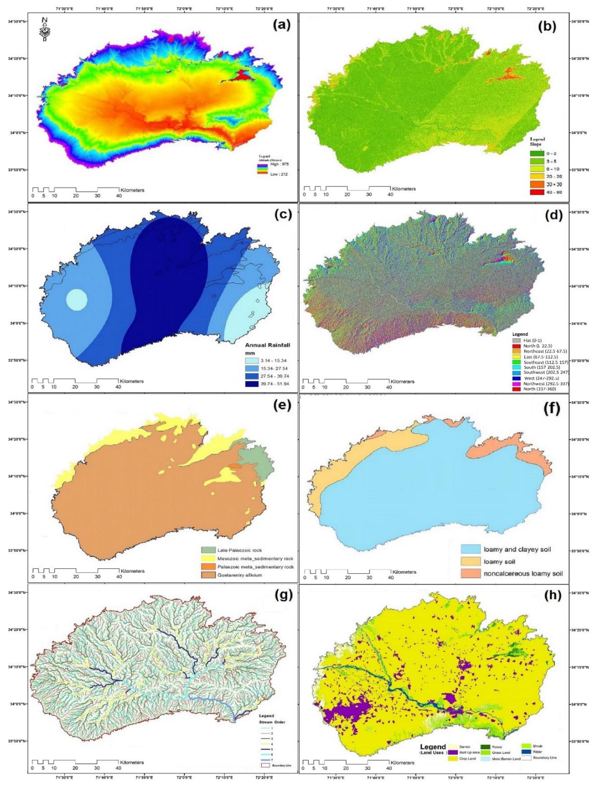
Digital Elevation Model (DEM) is a very useful tool to analyze topographic factors responsible for floods. There is a direct relation between topographic factors and runoff velocity. In most cases, the riverine flood-prone areas are characterized by low elevation and topographic slopes. Slope signifies the importance of gravity in generating runoff and its velocity. This factor is significantly important in hydrology. Floods tend to occur on gentle slopes despite the fact that steeper slope generates a faster flow. As a key factor of enhancing flood intensity, topography plays a vital role so far as the severity of flood is concerned. There is a direct relation between topographic factors and runoff velocity. In most cases, the riverine flood-prone areas are characterized by low elevation and a slight topographic slope. Digital Elevation Model (DEM) is a very useful tool to analyze topographic factors responsible for floods. For this purpose, the ALOS PALSAR DEM has been generated with a 12.5 m resolution. The DEM was processed in ArcGIS (10.5, Esri: Redlands, CA, USA) to delineate the Vale, and to prepare a slope and elevation map (Figure 4a).
Topographic slope refers to the angle between horizontal datum and the surface. It signifies the importance of gravity in generating runoff and its velocity. Hence, this factor is significantly important in hydrology. Practically, flood tends to occur on gentle slope despite the fact that a steeper slope generates a faster flow. In the study area, the maximum slope angle is 975 m while the minimum slope angle is 212 m (Figure 4b). Latest high-resolution DEM provides precise information and results.

3.4. Rainfall

The amount and location of precipitation are determined by the weather pattern. Stream mostly receive their water inflow from precipitation, and the quantity of precipitation in any given area varies on a daily, monthly and yearly basis. In order to develop a flood model, one of the most important factors is the data of precipitation or rainfall data. Rainfall has a significant relation with river discharge, and in the study area, it directly controls the flood occurrence. In the Peshawar Vale, most of the rainfall is received in the monsoon season. With heavy rainfall, there is a high river discharge (particularly in the Kabul River) which ultimately results in flooding the surrounding areas. Thus, flooding in the monsoon season is a common phenomenon in the study area. Therefore, precipitation data were obtained from 3 Meteorological stations (Table 1), that is, Peshawar, Cherat and Risalpur for the past 40 years. (Figure 4c) shows Rainfall interpolation map of the study area.

3.5. River Discharge

When a river/stream runs out of its confines, it inundates its surrounding area, the extent of which depends upon the amount of water in the stream. Many assume that only heavy rainfall can cause a flood. This is true but only part of the explanation. Floods can also be triggered when the water amount exceeds the river’s capacity to carry that flow. Thus, floods are partly caused by the rainfall and partly by the river’s capacity to contain water flowing in its channel. Data regarding the river discharge at various gauges stations have been collected and analyzed. The availability of data-dependent on the number of Gauging Stations. In the present study, data were collected from the available six Gauging stations. Peak discharge data of all the six rivers, that is, Kabul River, Swat River, Jindi River, Kalpani River, Budhni River and Bara River (Table 2) are collected for the past forty years (1980–2019) from their respective Gauging stations.

3.6. Flow Accumulation

Flow accumulation refers to the concentration of flow. Generally, in the upper region of the basin, the flow accumulation is lower. But as one moves towards the lower portion of the basin, there it witnessed a higher flow accumulation due to the fact that many tributaries join the main channel which results in increased flow accumulation and hence increases the vulnerability to floods. It is worth mentioning here that the lower part of the basin is thickly populated, which puts a large number of people prone to floods. Flow accumulation in the study area has been obtained using ArcMap 10.5 software (Esri: Redlands, CA, USA). With the help of the Arc toolbar and using the 3D Analyst tool, the resultant flow accumulation was obtained (Figure 4d).

3.7. Lithology

Permeability and porosity both depend on the lithological characteristics of a region. The intensity of the flood is influenced by such factors as rocks. Although the impact of lithology on floods is lesser as compared to other factors, still it has a role in intensifying the flood conditions. At the margins of the basin, dominant sedimentation has taken place in the shape of alluvial fans moving into the river basin. There has been a deposition of interbedded lacustrine sediments and the fluvial-floodplain more towards the basin. The major rocks found in the study area include sedimentary rocks, metasedimentary rocks and igneous rocks (Figure 4e).

3.8. Soil Texture

The study area is characterized by three different types of soil. They are; loamy and clayey soil, loamy soil and non-calcareous loamy soil. Piedmont soil is found in the upper part of the basin, while the central and lower part is predominantly characterized by the floodplain soil. It is the alluvium deposited by the Kabul River and its tributaries. (Figure 4f) shows the soil texture in the study area.

3.9. Drainage Pattern

The drainage pattern and drainage network highlight the hydrological behavior of a river and its tributaries. Most of the floods tend to occur in areas with high-density drainage because a large quantity of water is accumulated there. Factors such as stream order, stream frequency, drainage pattern, drainage density, bifurcation ratio, etc., play an important role in enhancing the condition of flood in an area. In the study area, drainage network analysis was performed with the help of hydrology tools in ArcMap. There exists a dendritic drainage pattern in the basin. A higher stream Order of 7th order was found in the subject area with a higher stream frequency (Figure 4g).

3.10. Flood Depth

Information about the extent of flood inundation is essential for understanding the vulnerability and future flood hazard along with some other variables. Satellite images-based flood inundation maps are used. Flood inundation maps provide vital information about the extent of the flood. Flood inundation maps are generated using topographic and hydraulic modeling and are not based on just historical flood observations. Such maps visualize a wider range of flood scenarios.

3.11. Land Use

In urban areas, the rapid pace of urbanization was greatly responsible for changes in hydrologic and hydraulic processes, disturbing the existing drainage network and its capacity and ultimately resulting in flooding. It augments the peak discharge and total runoff. Flood occurrence is inversely proportional to vegetation density. In this regard, wise, judicious and well-planned utilization of the available land is vital for sustainable development so that the economic conditions and wellbeing of an area are enhanced without any further deterioration that will be detrimental for the overall development. The spatial land-use analysis is carried out for the preparation of periodic land cover classification based on satellite images showing the extent of the study area. In order to achieve this task, two basic approaches were adopted. In the first place, the application of the Google Erath Engine (GEE) platform for land use analysis. Similarly, the application of the traditional method of land-use analysis with supervised and unsupervised imageries classification. The GEE platform and its libraries were used for the automation of the whole process, that is, from the selection of the study area on the basis of input (longitude, latitude) to mapping of the area and calculating spatial changes. Data of both the Landsat and Sentinel l–2 in collaboration with Google Cloud Storage were utilized for land uses analysis.
Images covering the study area were carefully selected having the least cloud cover. Different filters like filter by area, filter by date and filter by cloud were used in order to select the required images. Afterward, one image of the area was selected for processing. In the Applied classification techniques, the classifier (selecting sample for each class) was trained for each year. Random Forest Classifier has been applied in the current analysis. For each and every class, the Automated Area calculations were carried out and maps were exported into shapefiles for further analysis in ArcMap. In the second method, the ArcGIS Spatial Analyst extension, the Multivariate toolset provides tools for supervised classification. The Maximum Likelihood Classification tool is the chief classification technique. The required input for this tool is a signature file, which identifies the classes and their statistics. Using the Image Classification toolbar, and then using training sample, for supervised classification, the signature file is created. Spatial Analyst also provides tools for post-classification processing, such as filtering and boundary cleaning (Figure 4h).

4. Artificial Neural Network Model for Flood Hazard Zonation

The Artificial Neural Network Model is based on human perception and works like a human brain [30]. It can be trained to perform a specific task subject to the availability of empirical data. Artificial Neural Network (ANN) constitutes a powerful tool for modeling when the relationships among data set are complex [31]. A typical Artificial Neural Network is comprised of a number of neurons or nodes working in parallel and classifying input data into output classes [44,45]. Generally, an ANN consists of three layers; an input layer, an output layer and a hidden layer in between the input and output layers. There are sufficient neurons in each layer of the network. The data received by the input layer in the form of the thematic layer from various sources depends upon the nature of the work. Thus, the number of data sources present in the input layer determines the number of neurons in the corresponding input layer. The neurons present in the input layer highlight the various causative factors affecting floods. Both in the hidden (middle) and output layers, the complex phenomena of data processing take place. By trial and error, the number of layers along with their respective neurons are defined and determined in the input and hidden layers. While in the output layer, the neurons number is kept fixed and is represented by the class being processed.
In the present study, the Neural Network model was used to locate the bluespot and its filling capacity. It is a term used for a sink or a depression in the area. Bluespot is such an area that is likely to be overflowed or filled in a flood scenario posing threat to the infrastructure located within or nearby it. The concept is based on the hydrological perception that every bluespot possesses a catchment in the area and is contributing flow to that particular bluespot. After determining the bluespots and their capacity, the bluespot centroid is determined and values are calculated. For the training of the network, the Back-propagation algorithm has been used. To improve upon the Back-propagation, RProp algorithm was used. Morphometric analysis of the Kabul river watershed and the associated watersheds (Swat, Jindi, Kalpani, Budhni and Bara rivers) reveals that Peshawar Vale is vulnerable to frequent flooding for having low altitude, deposition of alluvium soil, low stream density, short flow accumulation and elongated shape of the basin. The resultant output of the ANN model in the shape of a map showing the flood level in the study area establishes a satisfactory agreement between the hydrological records and the one predicted by the model. This study reveals that an integrated utilization of GIS with ANN is a method with high precision and efficiency to predict the potential of a natural hazard such as a flood. The results of this study would help the local and national governments to understand the scenario for better planning and development in the subject area to protect the lives and properties of the people and sustain their livelihood along the Kabul River basin.

4.1. ANN Training, Testing and Results

ANN is a layered architecture that takes a set of inputs and uses combinational functions to produce a set of outputs (combinational functions combine inputs based on some well-defined criteria, which is usually just adding weighted inputs and biassed values). Because its value ranges from 0 to 1, the Sigmoid function is an excellent candidate for determining the similarity of predicted and actual values (Figure 5). The basic notion behind ANN is that when an error occurs, responsibility for the error is assigned to neurons according to their significance, and then the error is dispersed across neurons based on their impact on the output.
The method is repeated until the best weights for each parameter are found (i.e., neuron is obtained). Ann uses a deterministic technique rather than a probabilistic one.
The ANN approach is classified into two broad categories:
  • Training;
  • Validation.
For training and validation, all relevant parameters based on historic flood inundation are randomly distributed in two groups in the ratio of 75:25.
The algorithm of the training and validation module is as follow (Figure 6 and Figure 7):
The first step was to determine the capacity of the rainwater that can be handled by the area of interest (study area), for this purpose, the model was utilized to locate blue spot and its filling capacity. All low-lying regions whether they are developed ones or cultivated areas are exposed to some level of risk. In the case of a cultivated area, both the standing crops and equipment are under the threat. While in the case of the residential area, until and unless the residential buildings are built on pillars and high bases, they will be flooded whenever a high-level flood strikes the area.
Historical information on floods such as inundation, precipitation, discharge, etc., data was collected and utilized in our model. Historic data are subdivided into two parts in the present study; the training part and testing part in a ratio of 75 and 25, respectively. The first part is utilized for the determination of weights of each parameter and for the determination of biased value for flood inundation level detection. The resulting weights and biased values are tested on the remaining 25 percent of data to determine their effectiveness in the determination of floodable areas.
It is to be noted that structures even not sited in sinks might still be at risk. The adjacent area will experience flood if that much rainfall occurs that overflows a sink or depression at its so-called pour point. The term "bluespot" is just another term that is commonly used for a sink or a depression in the present study, and with regard to flood hazard, it carries a special notion. Thus, it is a region with the likelihood of overflow or to be filled in a flood condition, putting at risk all the structures that are located within it or nearby it.
A neural network is a mathematical model that establishes relationships between input parameters (such as rain fall, discharge rate, elevation, easting, northing, and so on) and output parameters (such as flood level) by adjusting the weights of the parameters and adding biased values using training data.
The Weights and Biased values are adjusted until the desired results are achieved. In the future, when suitable parameters are input, these weights of the parameters and biased values will be used to predict flood levels, and since flood levels at each place are obtained, these flood levels will be used to map prospective flood inundations. The neural network consists of Input Layer, Hidden Layer.
Take only three parameters to illustrate the algorithm: rainfall (denoted by “X1”), easting (denoted by “X2”), and northing (denoted by “X3”), as well as the output flood level (denoted by “Z”). (Figure 8).
Weights and Biased (“W11,” “W12,” “W21,” “W22,” “W31,” “W32,” “W41,” “W42,” “B1,” “B2,” and “B3”) values are adjusted until the flood level is within the acceptable tolerance of the known flood level. By entering easting, northing, and rain fall values, this neural network will predict flood levels.
The hydrologic concept is the basis for the model which states that each and every sink (bluespot) in the area possesses a local watershed or a catchment area: the area contributing flow only to that particular bluespot and not to any other point. By calculating the watershed area and the volume of a bluespot (sink), it is determined how much of rainfall will be needed for the bluespot to be filled. For instance, if a bluespot’s watershed is 25,000 m2 and its volume 1000 m3, the amount of rainfall required to fill the bluespot to its pour point will be 1000 m3/25,000 m2 = 0.04 m = 40 millimeters.
As it is a fact all the rainfall in a watershed does not flow entirely into the bluespot as there does not exist a perfect run-off condition. In a scenario of cloudburst, however, the run-off conditions are pretty much close to an ideal and perfect condition. The equation of water balance;
E P = I + E + A o + A u + Q
The above equation reveals that precipitation (P) is equal to the sum of vegetation interception (I), the amount of evaporation (E), the surface runoff (Ao), infiltration in soil and the prevailing drainage system (Au) local reservoirs deposition (Q). Thus, the local reservoir (Q) becomes a bluespot in the current context.
In a cloudburst condition (which was one of the major causes of floods-2010 in the study area), the soil infiltration, evaporation and interception by vegetation, all are assumed to be nil (zero). The maximum capacity of Peshawar Vale drainage system is approximately 40 mm rainfall/day. Focusing on rainfall of one hour, and assuming that within just one hour, the daily capacity can actually be handled, the value for Au (infiltration in soil and the prevailing drainage system) could be set to 40. Surplus runoff (Ao) in the area shall not be a serious factor in the equation until after the bluespot is filled up. hence, to calculate the value of fill up, for this purpose, the formula is simplified as;
P = 40 + Q   o r   Q = P 40   ( mm   per   hour )
If there occurs a rainfall of 90 mm in an hour, a 40 mm will be carried away by the sewerage system while the rest 50 mm will fall into the bluespot- filling it either entirely or partially. In case the bluespot is filled to its pour point, the run-off will thus flow into the next downstream bluespot or sink, that is, river, lake or sea. Once the bluespots and their capacities were determined, in the next step, the bluespot “Centroid” was determined and its x, y and z values were calculated.
The bluespots were determined based on a comparison of the volume of water required to fill the specific location and watershed area. The outliers were removed by using ArcGIS majority filter tool from the bluespots. Flood hotspots were determined by cluster analysis of the filtered bluespot data. The resultant map of data reveals the flood vulnerable areas on a specific amount of rainfall.
ANN is a complex mathematical function that is capable to accept numeric input and generating a numeric output. The output values are collectively determined by the input values, the hidden processing nodes, the hidden and output layers activation functions and a set of weights and bias values. Thus, a fully connected ANN with input “n”, hidden node, “h” and output “0” has (n × h) + h + (h × n) + n weights and biases. For instance, an ANN with 7 inputs, 4 hidden nodes, and 1 output will have (7 × 4) + 4 + (4 × 1) + 1 = 36 weights and biases. In the present study, the neural network set up was 9 input, 6 hidden and one output layer.
The ANN training process refers to finding out the values for the biases and weights so as for a set of training data with known values of inputs and output, the computed output of the network closely matches the known outputs. The back-propagation algorithm is one of the most common and widely used techniques used for training the neural network. This Back-propagation algorithm was utilized in the current study for the training of the neural network. It requires a value known as the learning rate for a parameter. The back-propagation level of effectiveness is quite sensitive to the value of the learning rate. For this purpose, in 1993, the researchers developed the Rprop for improving the algorithm of the back-propagation.

4.2. Understanding Gradients and the Rprop Algorithm

The RProp like other machine-learning algorithms, is also based on a mathematical concept known as the “gradient, mentioned in the graph (Figure 6f). The value of a single weight vs. the curve plots error. Here, the concept is that there must exist some measure of error and that the value of the error will change as the value of one weight changes, assuming that the values of the other weights and biases are kept as constant (same). A typical neural network with many biases and weights, for every bias and weight there will be a particular graph. Several "partial derivatives" make up a gradient. For a weight, a partial derivative is thought of as the slope of the tangent line (the slope and not the tangent line itself) to the error function for the weight value. Like, in Figure 9f, the partial derivative of the error with respect to weight" at weight = −5.0 is −0.90. The sign of the slope (partial derivative) is indicating the direction in which to go in order to have a smaller error. A negative slope would mean moving in the direction of the positive weight, while a positive slope would mean to in the direction of the negative weight. The slope steepness (magnitude) reveals how quickly the error is changing and at the same time it gives a clue at how far to move in order to get a smaller error.
The name partial derivatives indicate that these derivatives take only 1 weight into account; the other weights are thought to be the same (constant). The collection of all partial derivatives for all the associated weights and biases is termed as the gradient. It is to be kept in mind that though the word gradient is singular in itself but it is made up of several components. Similarly, both the terms partial derivatives and gradient are used often used interchangeably when the contextual meaning is clear.
During the training processes of the neural network, the magnitudes of the partial derivatives were used by the regular back propagation algorithm in order to determine how much a weight value was to be adjusted.
  • Blue Spot Analysis were performed by using ArcGIS model; (Figure 10a,b)
  • For dynamic determination of flood situation based on
  • Rainfall, river discharge, etc., a program developed based on RPROP of ANN.
  • Surface Development Using the developed program, a scenario of flood 2010 was generated showing the inundated area.

4.3. Flood Hazard Zones Generated by ANN

Once the respective networks were successfully trained and tested with the highest level of accuracy, it was used to get flood hazard zone classification. The output of the network (Figure 11) represents various FHZ classes thus obtained are free from bias, or any assumption. These are more appropriate and accurate than those produced by other models. The output of the model (ANN) can be in GIS for visualization of flood inundation areas and the extent of the flood. Therefore, this final map would help assess the rescue operations and also the number and type of infrastructure to be affected by the flood.

5. Summary and Conclusions

The main advantage of utilizing the Artificial Neural Network model is its objectivity in assigning weights to different causative factors, as they involve minimum human interference. The ANN has been widely used for various multisource classification problems. In the present study, the Artificial Neural Network has used the important flood causative factors like rainfall, river discharge, lithology, soil, slope, flow accumulation, flow direction, drainage pattern, flood depth, and land use analysis. In the ANN, the combined effects of these factors are refined in the hidden layers until a precise result of flood hazard zonation is produced as the output. In order to estimate the discharge of the rivers resulting in floods in the study area with no or limited prior statistics, experimental models like regional analysis of floods have been utilized. But, as the basin (KRB) is having unique basin characteristics, it is important to utilize such techniques and methods that are capable to simulate the flood discharge in accordance with the basic characteristics. The analysis of data has resulted in the zoning map of flood hazards in the whole area of the study area. The resultant map of ANN could be visualized in GIS. This output map represented the areas along Kabul River into Low, Medium and High vulnerable zones. The low-lying and nearby areas are included in the high flood hazard zone followed by moderate and low hazard zones. It is worth mentioning here that according to this map, most parts of District Nowshera and parts of Charsadda and Peshawar come under the category of High flood Risk zone.
The integration of the model with real-time data and a warning system can enhance the accuracy and reliability of flood early warning systems, which will ultimately reduce the risk of flood hazards. The combination of likelihood modeling, Neural Network and GIS open new horizons in hydrological modeling. The study shows that the results of ANN-derived flood hazard zonation are more accurate and precise than those obtained through an ordinal method-based. The present study concludes that the joint utilization of ANN algorithm and GIS spatial analysis function is of great efficiency for predicting, assessing and zonation of natural disasters like floods. The present study demonstrates and highlights the applicability and capability of the Neural Network Model for flood hazard zonation of a flood-prone area. Thus, this study will help the local residents and government agencies to identify areas with flood hazards and take adequate measures to safeguard and sustain the lives and properties of the people.

Author Contributions

M.S. was involved in proposal and the conceptualization of the research work and carried out the study and writing original draft preparation. S.U. contributed in data collection and the designing of research methodology. A.-u.R. reviewed and edited the manuscript. A.A. assisted in methodology and using GIS software, S.A. assisted in methodology and the application ANN modeling. R.K. assisted in draft preparation and data curation, W.H. contributed in the form of draft preparation and data validation. I.M. contributed in validation in investigation of the data. H.L. contributed in supervision and funding acquisition. All authors have read and agreed to the published version of the manuscript.

Funding

The APC was funded by Central South University, Changsha, Hunan, China.

Data Availability Statement

The datasets used in this study were obtained from the Provincial Irrigation Department, Khyber Pakhtunkhwa and Meteorological Stations of Peshawar, Cherat and Risalpur.

Acknowledgments

We appreciate and extend our thanks to the department of Meteorological Stations staff Peshawar for providing data. Similarly, we are also thankful to the Flood Forecasting Division (FFD), Lahore. Last but not least we are very pleased and acknowledge the support of the Geological Survey of Pakistan (GSP) and the Pakistan Bureau of Statistics (PBS) for this research.

Conflicts of Interest

The authors declare no conflict of interest.

References

  1. Feng, L.-H.; Lu, J. The Practical Research on Flood Forecasting Based on Artificial Neural Networks. Expert Syst. Appl. 2010, 37, 2974–2977. [Google Scholar] [CrossRef]
  2. Farooq, M.; Shafique, M.; Khattak, M.S. Flood Hazard Assessment and Mapping of River Swat Using HEC-RAS 2D Model and High-Resolution 12-M Tandem-X DEM (Worlddem). Nat. Hazards 2019, 97, 477–492. [Google Scholar] [CrossRef]
  3. Mahmood, S.; Rahman, A. Flash Flood Susceptibility Modeling Using Geo-Morphometric and Hydrological Approaches in Panjkora Basin, Eastern Hindu Kush, Pakistan. Environ. Earth Sci. 2019, 78, 43. [Google Scholar] [CrossRef]
  4. Ullah, K.; Zhang, J. GIS-Based Flood Hazard Mapping Using Relative Frequency Ratio Method: A Case Study of Panjkora River Basin, Eastern Hindu Kush, Pakistan. PLoS ONE 2020, 15, e0229153. [Google Scholar] [CrossRef] [PubMed] [Green Version]
  5. Rahman, A.; Mahmood, S.; Dawood, M.; Rahman, G.; Chen, F. Impact of Climate Change on Flood Factors and Extent of Damages in the Hindu Kush Region. In Oxford Research Encyclopedia of Natural Hazard Science; Oxford University Press: Oxford, UK, 2019. [Google Scholar]
  6. Mohd, M.S.; Alias, B.; Daud, D. GIS Analysis for Flood Hazard Mapping: Case Study Segamat, Johor, West Malaysia. In Proceedings of the Seminar Nasional GIS 2006: Geographic Information System Application for Mitigation in Natural Disaster, Jakarta, Indonesia, 29 November 2006; pp. 1–15. [Google Scholar]
  7. Falah, F.; Rahmati, O.; Rostami, M.; Ahmadisharaf, E.; Daliakopoulos, I.N.; Pourghasemi, H.R. Artificial Neural Networks for Flood Susceptibility Mapping in Data-Scarce Urban Areas. In Spatial Modeling in GIS and R for Earth and Environmental Sciences; Elsevier: Amsterdam, The Netherlands, 2019; pp. 323–336. [Google Scholar]
  8. Kenyon, W.; Hill, G.; Shannon, P. Scoping the Role of Agriculture in Sustainable Flood Management. Land Use Policy 2008, 25, 351–360. [Google Scholar] [CrossRef]
  9. Mikhailov, V.N.; Morozov, V.N.; Cheroy, N.I.; Mikhailova, M.V.; Zav’yalova, Y.F. Extreme Flood on the Danube River in 2006. Russ. Meteorol. Hydrol. 2008, 33, 48–54. [Google Scholar] [CrossRef]
  10. Hossain, B.; Sohel, M.S.; Ryakitimbo, C.M. Climate Change Induced Extreme Flood Disaster in Bangladesh: Implications on People’s Livelihoods in the Char Village and Their Coping Mechanisms. Prog. Disaster Sci. 2020, 6, 100079. [Google Scholar] [CrossRef]
  11. Jonkman, S.N.; Kelman, I. An Analysis of the Causes and Circumstances of Flood Disaster Deaths. Disasters 2005, 29, 75–97. [Google Scholar] [CrossRef]
  12. Zhang, Q.; Xu, C.-Y.; Zhang, Z.; Chen, Y.D.; Liu, C.; Lin, H. Spatial and Temporal Variability of Precipitation Maxima during 1960–2005 in the Yangtze River Basin and Possible Association with Large-Scale Circulation. J. Hydrol. 2008, 353, 215–227. [Google Scholar] [CrossRef]
  13. Khan, A.N.; Collins, A.E.; Qazi, F. Causes and Extent of Environmental Impacts of Landslide Hazard in the Himalayan Region: A Case Study of Murree, Pakistan. Nat. Hazards 2011, 57, 413–434. [Google Scholar]
  14. Khan, A.N.; Ali, A. Implication of Floods—2010 on Education Sector in Pakistan. In Disaster Recovery; Springer: Cham, Switzerland, 2014; pp. 117–133. [Google Scholar]
  15. Baig, M.A. Floods and Flood Plains in Pakistan. In Proceedings of the 20th International Congress on Irrigation and Drainage, Lahore, Pakistan, 13–18 October 2008. [Google Scholar]
  16. Tehrany, M.S.; Lee, M.-J.; Pradhan, B.; Jebur, M.N.; Lee, S. Flood Susceptibility Mapping Using Integrated Bivariate and Multivariate Statistical Models. Environ. Earth Sci. 2014, 72, 4001–4015. [Google Scholar] [CrossRef]
  17. Kumar, R. Flood Hazard Assessment of 2014 Floods in Sonawari Sub-District of Bandipore District (Jammu&Kashmir): An Application of Geoinformatics. Remote Sens. Appl. Soc. Environ. 2016, 4, 188–203. [Google Scholar]
  18. Li, Y.; Li, H.X.; Huang, J.; Liu, C. An Approximation Method for Evaluating Flash Flooding Mitigation o Sponge City Strategies – A Case Study of Central Geelong. J. Clean. Prod. 2020, 257, 120525. [Google Scholar] [CrossRef]
  19. Islam, M.M.; Sado, K. Development Priority Map for Flood Countermeasures by Remote Sensing Data with Geographic Information System. J. Hydrol. Eng. 2002, 7, 346–355. [Google Scholar] [CrossRef]
  20. Dixon, B. Applicability of Neuro-Fuzzy Techniques in Predicting Ground-Water Vulnerability: A GIS-Based Sensitivity Analysis. J. Hydrol. 2005, 309, 17–38. [Google Scholar] [CrossRef]
  21. Toosi, A.S.; Doulabian, S.; Tousi, E.G.; Calbimonte, G.H.; Alaghmand, S. Large-Scale Flood Hazard Assessment under Climate Change: A Case Study. Ecol. Eng. 2020, 147, 105765. [Google Scholar] [CrossRef]
  22. Biswajeet, P.; Mardiana, S. Flood Hazrad Assessment for Cloud Prone Rainy Areas in a Typical Tropical Environment. Disaster Adv. 2009, 2, 7–15. [Google Scholar]
  23. Cunderlik, J.M.; Burn, D.H. Analysis of the Linkage between Rain and Flood Regime and Its Application to Regional Flood Frequency Estimation. J. Hydrol. 2002, 261, 115–131. [Google Scholar] [CrossRef]
  24. Pradhan, B.; Youssef, A.M. Manifestation of Remote Sensing Data and GIS on Landslide Hazard Analysis Using Spatial-Based Statistical Models. Arab. J. Geosci. 2010, 3, 319–326. [Google Scholar] [CrossRef]
  25. Sezer, E.A.; Pradhan, B.; Gokceoglu, C. Manifestation of an Adaptive Neuro-Fuzzy Model on Landslide Susceptibility Mapping: Klang Valley, Malaysia. Expert Syst. Appl. 2011, 38, 8208–8219. [Google Scholar] [CrossRef]
  26. Oh, H.-J.; Pradhan, B. Application of a Neuro-Fuzzy Model to Landslide-Susceptibility Mapping for Shallow Landslides in a Tropical Hilly Area. Comput. Geosci. 2011, 37, 1264–1276. [Google Scholar] [CrossRef]
  27. Nardi, F.; Vivoni, E.R.; Grimaldi, S. Investigating a Floodplain Scaling Relation Using a Hydrogeomorphic Delineation Method. Water Resour. Res. 2006, 42, W09409. [Google Scholar] [CrossRef]
  28. Grimaldi, S.; Petroselli, A.; Arcangeletti, E.; Nardi, F. Flood Mapping in Ungauged Basins Using Fully Continuous Hydrologic–Hydraulic Modeling. J. Hydrol. 2013, 487, 39–47. [Google Scholar] [CrossRef]
  29. Hoptroff, R.G. The Principles and Practice of Time Series Forecasting and Business Modelling Using Neural Nets. Neural Comput. Appl. 1993, 1, 59–66. [Google Scholar] [CrossRef]
  30. Kia, M.B.; Pirasteh, S.; Pradhan, B.; Mahmud, A.R.; Sulaiman, W.N.A.; Moradi, A. An Artificial Neural Network Model for Flood Simulation Using GIS: Johor River Basin, Malaysia. Environ. Earth Sci. 2012, 67, 251–264. [Google Scholar] [CrossRef]
  31. Biswajeet, P.; Saied, P. Comparison between Prediction Capabilities of Neural Network and Fuzzy Logic Techniques for L and Slide Susceptibility Mapping. Disaster Adv. 2010, 3, 26–34. [Google Scholar]
  32. Minns, A.W.; Hall, M.J. Artificial Neural Networks as Rainfall-Runoff Models. Hydrol. Sci. J. 1996, 41, 399–417. [Google Scholar] [CrossRef]
  33. Kasiviswanathan, K.S.; Sudheer, K.P.; He, J. Probabilistic and Ensemble Simulation Approaches for Input Uncertainty Quantification of Artificial Neural Network Hydrological Models. Hydrol. Sci. J. 2018, 63, 101–113. [Google Scholar] [CrossRef]
  34. Tealab, A. Time Series Forecasting Using Artificial Neural Networks Methodologies: A Systematic Review. Future Comput. Inform. J. 2018, 3, 334–340. [Google Scholar] [CrossRef]
  35. Poonia, V.; Tiwari, H.L. Rainfall-Runoff Modeling for the Hoshangabad Basin of Narmada River Using Artificial Neural Network. Arab. J. Geosci. 2020, 13, 1–10. [Google Scholar] [CrossRef]
  36. Jain, S.K.; Mani, P.; Jain, S.K.; Prakash, P.; Singh, V.P.; Tullos, D.; Kumar, S.; Agarwal, S.P.; Dimri, A.P. A Brief Review of Flood Forecasting Techniques and Their Applications. Int. J. River Basin Manag. 2018, 16, 329–344. [Google Scholar] [CrossRef]
  37. Merkuryeva, G.; Merkuryev, Y.; Sokolov, B.V.; Potryasaev, S.; Zelentsov, V.A.; Lektauers, A. Advanced River Flood Monitoring, Modelling and Forecasting. J. Comput. Sci. 2015, 10, 77–85. [Google Scholar] [CrossRef]
  38. Campolo, M.; Andreussi, P.; Soldati, A. River Flood Forecasting with a Neural Network Model. Water Resour. Res. 1999, 35, 1191–1197. [Google Scholar] [CrossRef]
  39. Islam, A.S. Improving Flood Forecasting in Bangladesh Using an Artificial Neural Network. J. Hydroinformatics 2010, 12, 351–364. [Google Scholar] [CrossRef] [Green Version]
  40. Iqbal, M.S.; Dahri, Z.H.; Querner, E.P.; Khan, A.; Hofstra, N. Impact of Climate Change on Flood Frequency and Intensity in the Kabul River Basin. Geosciences 2018, 8, 114. [Google Scholar] [CrossRef] [Green Version]
  41. Lashkaripour, G.R.; Hussaini, S.A. Water Resource Management in Kabul River Basin, Eastern Afghanistan. Environmentalist 2008, 28, 253–260. [Google Scholar] [CrossRef]
  42. Kottek, M.; Grieser, J.; Beck, C.; Rudolf, B.; Rubel, F. World Map of the Köppen-Geiger Climate Classification Updated. Meteorol. Z. 2006, 15, 259–263. [Google Scholar] [CrossRef]
  43. Bibi, T.; Nawaz, F.; Abdul Rahman, A.; Latif, A. Flood Hazard Assessment Using Participatory Approach and Weighted Overlay Methods. Int. Arch. Photogramm. Remote. Sens. Spat. Inf. Sci. 2019, XLII–4/W16, 153–160. [Google Scholar] [CrossRef] [Green Version]
  44. Atkinson, P.M.; Tatnall, A.R.L. Introduction Neural Networks in Remote Sensing. Int. J. Remote Sens. 1997, 18, 699–709. [Google Scholar] [CrossRef]
  45. Tsakiri, K.; Marsellos, A.; Kapetanakis, S. Artificial Neural Network and Multiple Linear Regression for Flood Prediction in Mohawk River, New York. Water 2018, 10, 1158. [Google Scholar] [CrossRef] [Green Version]
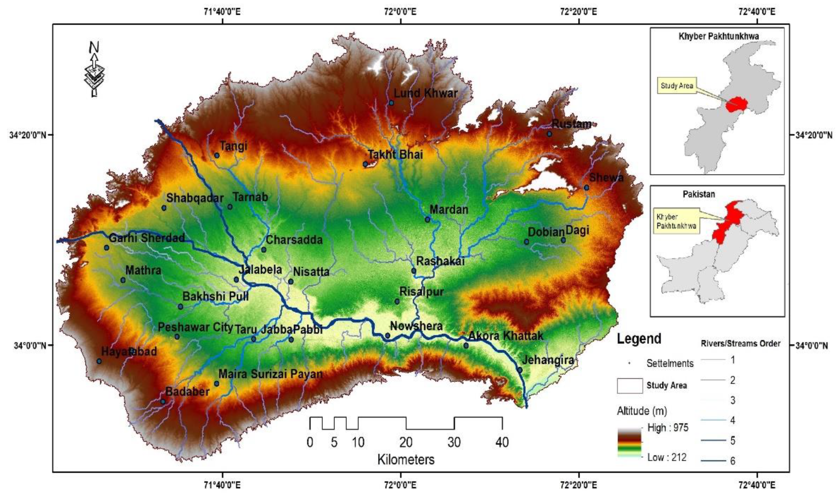
Figure 1. Location of the study area.
Sustainability 13 13953 g001
Figure 2. Flow chart of research process adopted.
Sustainability 13 13953 g002
Figure 3. A typical Artificial Neural Network for Flood Hazard Zonation.
Sustainability 13 13953 g003
Figure 4. Topographic slope refers to the angle between the horizontal datum and the surface. It signifies Figure 4. (a) Digital Elevation Model; (b) Slope; (c) Rainfall Interpolation; (d) Flow Accumulation; (e) Geology; (f) Soil; (g) Drainage Pattern; and (h) Land Use.
Sustainability 13 13953 g004
Figure 5. Sigmoid function.
Sustainability 13 13953 g005
Figure 6. Flow Chart of Alogrithim of ANN Training.
Sustainability 13 13953 g006
Figure 7. Validation process of ANN.
Sustainability 13 13953 g007
Figure 8. Training of ANN.
Sustainability 13 13953 g008
Figure 9. (a) Pour Point; (b) Blue Spot; (ce) ANN application developed for flood inundation pattern recognition and prediction of flood inundation at area of interest; (f) Curve Plots Error; (g) Weight Value Adjustment; (h,i) Blue Spot Analysis.
Sustainability 13 13953 g009
Figure 10. (a) Blue Spot & Flood Danger Zones Map using ANN. (b) Blue Spot Map Using ANN.
Sustainability 13 13953 g010
Figure 11. Flood Hazard Zones using ANN.
Sustainability 13 13953 g011
Table 1. Meteorological Stations in the study area.
S.NOMeteorological StationLat/Long Altitude (m)Mean Annual Precipitation (mm)
1Peshawar34°2′/71°56′328484
2Cherat33°49′/71°33′892592
3Risalpur34°3′/71°58′312523
Table 2. River with their respective gauging stations.
S.NoRiversGauging Station
1Kabul RiverWarsak Dam
2Swat RiverMunda Headworks
3Kalpani RiverRisalpur
4Budhni RiverDarmangi, Peshawar
5Jindi RiverUtmanzai, Charsadda
6Bara RiverG.T Road, Tarnab
Publisher’s Note: MDPI stays neutral with regard to jurisdictional claims in published maps and institutional affiliations.