Abstract
In this paper we propose a goal programming model that provides a consensual aggregated solution minimizing conflicts to guide multi-stakeholder decision-making processes and generates information regarding stakeholder groups to be exploited for negotiation purposes. This model permits to quantify variations in conflicts when the relative contribution of each criteria changes and gives insight to negotiation strategies with application in conservation areas. A dataset of a case study in the Meseta Ibérica Biosphere Reserve (Portugal-Spain) was used to test and validate the model. Fifty people belonging to four groups (scientists, government, farmers and businesspersons) assessed 20 management objectives in four dimensions: conservation, logistical support, development, and governance. The results showed the highest conflicts to be found for fauna and flora, education, and guarantees objectives while the most conflictive groups were scientists and farmers. The proposed model substantially reduced the global and intergroup conflicts associated to the same objectives, modelling the weights assigned to each objective in each dimension to find the most consensual/least conflictive solutions. This model can be a useful tool to improve complex decision-making processes in conservation areas with strong conflicts between stakeholders, such as transboundary biosphere reserves.
1. Introduction
Decision-making related to protected areas planning and management is difficult to carry out due to inherent conflicts among stakeholders with divergent interests, making consensual solutions hard to achieve [1]. Restrictions affecting owners, managers, and local residents, as well as low access of these groups to decision-making, lack of communication among stakeholders and exclusion of particular groups of stakeholders, such as landowners, from decision-making processes, are factors that foster the perception that nature conservation policies affect negatively local communities, both economically and socially [2]. This perception creates feelings of frustration within some stakeholders’ groups, promoting conflicts that sometimes result in anti-environmental behaviors or even environmental crimes, such as wildlife poisoning or illegal fire-setting [3]. Conflicts, therefore, entail the risk of blocking relevant conservation as well as socioeconomic and political processes, affecting effectiveness of conservation measures and compliance with protected area goals and objectives. For these reasons, participative approaches, good communication, clarity, and justification of decisions, and good coordination among different institutional levels in planning, contribute to minimizing conflicts, making these principles essential to ensure good governance and effective strategic environmental assessment [4].
The risk of conflict (and its consequences) increases in transboundary conservation areas due mainly to two elements. One is the difficulty to develop common conservation policies for socioecological systems shared by two countries because international political borders usually do not coincide with natural ecological boundaries [5]. The second is the complexity of governance derived from inter and intra-country government levels, aggravated by the different perceptions of stakeholders’ groups due to cultural and institutional differences [6], which implies that conservation priorities might also diverge between countries [7]. In addition, in recently established conservation areas, these problems can be even more critical since there are new actors and institutions involved and the mechanisms to address conflicts are not yet in place.
Control and minimization of conflicts is now considered paramount in nature conservation and it is becoming more relevant in the framework of international policy [8]. Moreover, a growing number of studies has been oriented to the identification of conservation conflicts [9,10,11,12,13,14,15,16,17,18,19,20,21,22,23,24,25,26,27,28,29,30,31,32,33,34,35,36,37,38,39,40] and the development of tools to address them [41,42,43,44,45,46,47,48,49].
Building and maintaining trust with landowners, managers and other stakeholders is an essential step for conservation authorities, but this process requires efforts and resources [50]. It involves willingness to share knowledge and power regarding policy-making and practice, particularly when local stakeholders rely on natural resources. It also implies the development or improvement of mechanisms and tools to promote consensus among groups and guide negotiation processes opening opportunities for dialogue, in particular to facilitate the selection of common points of view between stakeholders’ groups or solutions wide enough to cover the interests of all groups [51]. In this sense, multi-criteria decision-making (MCDM) techniques based on linear programming or hierarchical methods have shown to be useful to support effective decision-making and solve complex decision processes such as those involved in planning and management of transboundary conservation areas [7].
Biosphere reserves are a good example of transboundary conservation areas where governance challenges are particularly relevant and complex. The Biosphere Reserve (UNESCO) is the conservation area concept that involves the most balanced aggregation of the three dimensions of sustainability: environmental (conservation), economic and social. These reserves are established in areas of high conservation value but also including human settlements and natural or semi-natural managed systems, such as forests and farmland, where social and economic activity is often relevant. In addition, biosphere reserves provide unique learning opportunities from an integrated society-nature approach [50]. In these areas, where land is the source of basic resources for groups of stakeholders, such as farmers or businesspersons, the emerge of conflicts can be much more likely than in strict conservation areas where human settlements are absent. Although Biosphere Reserves provide important opportunities for sustainable development, there are groups of stakeholders who can be particularly affected by decisions regarding conservation. In this context, scale, dynamics and trade-offs between conservation goals can be key to the success of the establishment and management of reserves [52]. For this reason, in these areas goals and management objectives should be defined carefully and decision-making processes should be supported by consensuses involving all stakeholders.
The objective of this paper is to propose a goal programming (GP) model to assign consensual weights expressing the importance of management objectives in protected areas. The novelty of this GP model lays in its ability to define optimal weights to criteria, minimizing global and intergroup conflicts. The model can contribute to reduce conflicts among stakeholders’ groups and to guide negotiation processes based on the relative importance of management objectives, providing a common framework to learn and share knowledge. To illustrate the application of the model we present a case study in the Portuguese-Spanish Meseta Ibérica Transboundary Biosphere Reserve.
The paper is structured as follows: In the second and third sections we provide a literature review on participatory MCDM in protected areas, assessment of conservation conflicts, and MCDM methods looking for consensual decisions. In the fourth section we present the methodology used in the model development and its application in the case study of Meseta Ibérica Transboundary Biosphere Reserve. The fifth and sixth sections are dedicated to the presentation and discussion of the results of the research, respectively, and in the seventh section we draw conclusions about the development and application of the model.
2. The Challenge of Managing Conflicts in Protected Areas
The concern about conflict management in protected areas has promoted the development of participative MCDM methods since early 20th century. These methods have been applied to solve decision-making problems, in particular about freshwater provisioning and land use [53]. The role of MCDM methods in this regard has been very relevant since these are rigorous methods and make it possible to structure complex decisional problems involving a high number of criteria, alternatives and participants. As consequence, the combined use of MCDM and soft methods, such as workshops or citizens’ juries, has grown considerably in the last decade.
Combined geographic information systems (GIS) and MCDM techniques have been applied in participatory spatial decision-making, land use assessment, urban-planning and environmental assessment [10]. GIS visual tools facilitate the aggregation of preferences of stakeholders in a simple and intuitive way [10]. de Oliveira and Partidário [11] provided a review of spatial visual tools in environmental impact assessment (EIA) decision-making processes and found that although the social benefits of visual analyses are widely recognized in the literature, the cultural, social, political, or structural context in which they are used can be determinant for their effectiveness. Despite advances, the adequacy of tools of this nature for different stakeholders’ groups has not been sufficiently studied.
Recent studies used GIS-MCDM to assess nature-based tourism, conservation, and overall sustainability strategies. Rocchi et al. [12] proposed a spatial multi-criteria analysis to detect spatial conflicts regarding nature-based tourism and ecological protection in a region of Italy. Their methodology allowed the evaluation of the potential of the Natura 2000 Network to provide recreation services in the region and the identification of sites where tourism activities could be developed and improved, respecting biodiversity conservation criteria. Kazana et al. [13] combined GIS, the analytic hierarchy process (AHP) and fuzzy analysis to assess sustainable forest management considering conflicts and interests of different stakeholders in Eastern Macedonia and Thrace Region in Northern Greece. They accessed the performance of seven forest management strategies at the regional level and calculated an Overall Forest Sustainability Performance Index in each of the study areas. Sumida and Valente [14] prioritized protection areas in the Piedade municipality, Brazil, using a combined AHP-GIS method. Decisional problems regarding sustainable forestry planning have also been analyzed with MCDM methods [19,20,21,22,23,24]. Tuda et al. [39] used MCDM techniques and spatial analysis to identify conflict hotspots in Mombasa Marine National Park and Reserve. They calculated objective weights using AHP, mapped conflict levels in a GIS, and used a goal programming approach to identify optimal uses that minimize conflicts regarding use patterns in marine protected areas. Cieslak [40] used GIS, AHP, and DEMATEL (Decision-Making Trial and Evaluation Laboratory) methods to identify conflicts in a rural region in Poland. She proposed an index to assess the intensity of factors that drive land use conflicts regarding spatial attributes, surrounding areas and public infrastructure.
In the case of protected areas, MCDM methods have been applied to define management strategies. Sturiale et al. [21] used a rough sets approach to classify crops according to five sustainability attributes in a Sicilian Regional Park. Portillo et al. [22] applied an analytic network process (ANP) methodology to prioritize rural development strategies in protected areas based on nine strategic lines of the LEADER program (Liaison Entre Actions de Développement de l’Économie Rurale) and they found that this sophisticated method provided a ranking which fitted better to the LEADER approach than a simple mean of preferences regarding identified strategic lines and objectives. Kukkonen and Tammi [23] applied a gap analysis and a regression method to re-define the protected area network in Laos.
Some studies focused on an ecosystem services approach to guide participatory MCDM processes to improve management strategies in forests, coastal areas, peatlands, mountain protected areas, and rural sites [24,25,26,27,28]. These studies focused on the improvement of management strategies from a participatory multi-criteria approach assessing institutional actors but they did not consider the preferences of private owners. Other studies included the preferences of a wider range of stakeholders to analyze conflicts between stakeholders’ groups. Oduro-Ofori et al. [29] assessed structural, data, and interest conflicts related to the use of natural resources in a strict nature reserve in Ghana. Structural conflicts refer to inequalities in control, authority, power, institutional limitations, geographic distance or ownership. Data conflicts arise when there is lack of information, data is interpreted differently by several stakeholders or is retained by one stakeholder. Interest conflicts refer to actual or perceived scarce resources. These authors found conflicts regarding land, water, game and timber, and the nature of these conflicts was linked to intervention, and economic and environmental damage. Schirpke et al. [30] provided a framework to address conflicts focused on cultural ecosystem services in mountain regions.
Jäger et al. [31], Franklin et al. [32], Hovardas [33], and Verschueren et al. [34] analyzed more specific conflicts related to animal species. Jäger et al. [31] and Franklin et al. [32] assessed conflicts between winter recreational activities and grouse species, and between forestry and moose populations, respectively, and proposed tools to manage them. Hovardas [33] and Verschueren et al. [34] assessed conflicts of humans with carnivores in protected areas in Greece and Namibia, respectively. These studies highlighted the problems carried by the coexistence of wildlife and humans that are particularly serious in protected sites.
Conflicts regarding land use alternatives in planning have been studied recently [35,36,37]. Morea [35] analyzed conflicts in Bahía de San Antonio, a protected area in Argentina, applying semi-structured interviews to social actors and GIS, based on current planning and objectives of the reserve. Main conflicts were found between land use and conservation due to the incompatibility of some uses and activities at institutional and political levels and due to land-use changes. Marques et al. [36] assessed conflicts analyzing actors’ power considering coercion, some incentives and dominant information criteria. They presented a case study based on interviews to 44 actors in Vale do Sousa (Portugal) and categorized power in forest management in high, medium and low impact levels. They identified two major conflicts: One between the economic and nature protection coalitions and the social and recreational coalition, and another between the monoculture of eucalypt for wood supply and biodiversity conservation groups. Yuxi and Linsheng [37] assessed the evolution of conflicts between nature-based tourism and ecological protection in China using a composite dynamic indicator of conflict tendency with parameters of landscape attractiveness and ecological sensitivity. Skjeggedal et al. [38] proposed a qualitative oriented consensual solutions approach applying multilevel governance to land use planning in mountain regions. They described a case study in Dovrefjell (Norway) and proposed a common arena at the local level to deal with the hardest conflicts.
3. Context and Rationale of Study
The identification of conflicts is the first step towards consensus. MCDM techniques can provide quantitative tools to assess complex problems involving several decision-makers in a rigorous and structured manner. However, the aggregation of individual assessments can result in different global solutions. This issue is key to guide participatory decision-making processes to minimize conflicts and bring stakeholder positions closer together. In this sense, hard MCDM methods, such as linear programming or integer programming and utility-based methods, have been used for eliciting views in decision-making [42]. Some studies have applied multiplicative methods in order to compare non-compensatory criteria and added uncertainty. Driscoll et al. [43] proposed a model based on the utility with additive and multiplicative weighting to assess 22 planed burning alternatives and eight objectives: House protection, maximizing water quality, minimizing carbon emissions and impacts on human health, and minimizing declines in five species. This model solved conflicts involving one arboreal mammal and water quality through a compensatory weighting scheme. Liu et al. [44] dealt with conflicts in decision-making processes with a new model based on multiplicative data envelopment analysis (DEA) cross-efficiency and stochastic weight space acceptability analysis. They assumed decision-makers weights as a uniform distribution for acceptability analysis. Their model provided an optimal ranking that minimized the total rank of unacceptability.
Other studies proposed an outranking MCDM approach. de Oliveira Silva and de Almeida-Filho [45] applied a MCDM method based on the ELECTRE-TRI method to integrate subjectivity in human judgments into the classification of the conflict in Dempster-Shafer Theory (DST), classifying conflicts in high, medium and low. This method uses a concordance and a discordance index to assess each judgement. Thus, vagueness in human judgments is structured in relation to a preference threshold and an indifference threshold. Frini and Amor [46] proposed the Multi-Criteria Multi-Period Outranking Method (MUPOM) to deal with sustainable development in a temporal perspective. This is a semi-compensatory method that uses pairwise comparisons in each temporal period and concordance and discordance thresholds to identify a discordance index. The authors applied the model to prioritize five forest management strategies.
More studies addressed consensus more specifically when different groups are involved in decision-making processes. González-Pachón and Romero [47] proposed a goal programming (GP) model to solve a social choice problem using integer variables to define Condorcet functions. This model permits the generalization of the social choice function structure and provides consensus-ordinal-rankings. González-Pachón et al. [48] presented a GP model based on three systems of weights in voting systems: “one person, one vote”, “one social group, one vote” and “maximum deviation or discrepancy between rules 1 and 2 minimized”. This model provided a power index that allowed investigating group vs. individual trade-offs.
The challenge to managing conflicts lays mostly in the two approaches presented before: identification of conflicts and provision of solutions based on consensus. Identification of conflicts has been long addressed from a great diversity of perspectives and methods. However, although hard MCDM methods have been considered to aggregate preferences of multiple participants in decision-making processes, research oriented to guiding consensuses using hard methods remains rare.
In this paper, we propose a new GP model to guide decisional processes towards consensuses on the importance of management objectives (MO) in conservation areas. This model provides an aggregated solution that minimizes both the maximum intergroup distances and the maximum distances to the global solution. The model pinpoints the most consensual weights to each MO, in addition to output a consensual ranking. This procedure/method improves the previously developed models by, on one hand, providing more accurate results and, on the other hand, adding flexibility to the method in order to guide negotiation processes between groups through modelling of weights as a function of the relative contribution of each MO, proposed by stakeholders’ groups or by experts. This allows to fix limits of tolerance to each MO. The model was applied in a transboundary biosphere reserve, Meseta Ibérica (Spain-Portugal), a conservation area with potentially strong conflicts between stakeholders’ groups regarding conservation objectives and a very complex decision-making system [6].
4. Materials and Methods
4.1. Study Area
The Meseta Ibérica is located on the NW of the Iberian Peninsula (Figure 1) and was designated as a Transboundary Biosphere Reserve in 2015. With 1,132.607 ha, it is the largest transboundary reserve in Europe. At present, in Portugal, it comprises two natural parks (Parque Natural do Montesinho and Parque Natural do Douro International) and two local protected areas (Paisagem Protegida da Albufeira do Azibo and Parque Natural Regional do Vale do Tua) and, in Spain, two natural parks (Parque Natural de Lago de Sanabria y alrededores and Parque Natural de los Arribes del Duero). Protected areas were established from 1979 (Montesinho) to 2013 (Vale do Tua) in Portugal and in 1978 (Sanabria) and 2002 (Arribes del Duero) in Spain. The Natura 2000 network was established in late 1990s–early 2000s in both countries. These conservation areas and other areas are combined in the Biosphere Reserve, according to the overall model of the Man and Biosphere Program (MaB) as core, buffer, and transition zones. The area of the reserve includes and involves 12 Portuguese municipalities, and 48 and 12 Spanish municipalities in two Diputaciones, Zamora and Salamanca, respectively.
The Meseta Ibérica is located on the transition between the Mediterranean and Atlantic biogeographic zones. It is dominated by a mountainous landscape where climate is temperate oceanic sub-Mediterranean [54]. The socio economy of the area is characterized by a low demographic density (14 inhabitants per km2) and a local economy based on agroforestry and tourism. The area faces problems such as demographic decline and ageing. Rural depopulation and the increasing farmland abandonment has been an important trend in the near past which increases the risk of larger wildfires [55] requiring careful planning to address simultaneously all nature conservation objectives and the preferences of different stakeholders’ groups.

Figure 1.
Location of the Meseta Ibérica Biosphere Reserve and in the Iberian Peninsula. Source: [56].
Figure 1.
Location of the Meseta Ibérica Biosphere Reserve and in the Iberian Peninsula. Source: [56].

Stakeholder groups in the reserve are comprised mainly by governments and private owners, businesspersons, and scientists [7]. Both in Portugal and Spain there are several government levels involved in the management of the Reserve. On the Portuguese side, government entities correspond to the local administration levels (parishes, municipalities and community of municipalities (CIM)) and the national government authorities that are responsible for the management of Natural Parks and Natura 2000 sites and leading members of the MaB Programme in Portugal (MaB Portugal Committee). In Spain, there are local and municipal government agents and, to a lesser degree, the regional government through protected areas and Natura 2000 sites comprising the Reserve. There is, additionally, a transnational entity, the ZASNET European Grouping of Territorial Cooperation (EGTC), that is directly responsible for the management of the Biosphere Reserve. ZASNET is comprised of two municipalities associations plus the municipality of Bragança, on the Portuguese side, and of Ayuntamiento de Zamora, and Diputación de Zamora, and Diputación de Salamanca, in Spain.
The structure of the stakeholder groups is, therefore, not simple because it not just involves several levels of political organization that sometimes overlap, but also because individual agents can be involved in two or more groups simultaneously. For example, a mayor can be a farmer and an owner of a rural hostel and can also act individually and as member of a farming, forest, animal breeding, beekeeping, tourism, or game association.
The relatively recent conservation status of this area has created new restrictions and use land limitations derived from conservation measures generating, sometimes, strong conflicts between local stakeholder groups and the government bodies involved in the planning and management of the area. This has happened mostly for the protected areas established since the late 1970s. The recent biosphere reserve has emerged as a new conservation figure in the area, creating additional challenges but it is also an opportunity to facilitate communication and decision-making processes to anticipate and manage conflicts and promote consensual decisions that ensure conservation of nature and improve welfare of local communities. However, conflicts affect the ongoing planning and management efforts in the recently established Reserve and the lack of consensus regarding key issues, such as the prioritization of objectives, will make it hard for the Reserve to fulfil its goals.
As seen above, decision-making in Meseta Ibérica is extremely complex and not always straightforward given the diversity of entities involved, their competences and their own decision-making processes, often independent from each other. Authorities from both sides of the border, for example, although committed to the Biosphere Reserve objectives and master plan, decide independently from each other. As in the case of other EGTC, ZASNET objectives are mainly to facilitate and promote cross-border, transnational and interregional cooperation and social and economic cohesion but this entity has no direct decision power or executive power on issues related to land planning, forestry, game management or water management, among many others, within the biosphere reserve relying, therefore, on national, regional, and local authorities on both sides of the border.
4.2. Data and Previous Work
The dataset used to test and validate the model proposed in this paper was obtained from a previous study undertaken in The Meseta Ibérica Biosphere Reserve and described in detail in [7]. The data refers to the preferences of stakeholders regarding the relevance that individual management objectives should have in the planning of the protected area.
The management objectives of the Biosphere Reserve had been organized hierarchically so that their main dimensions were firstly defined and then the objectives were included in each dimension, following an increasing level of specificity [7]. The main dimensions were defined based on the three key axes that guide the establishment and management of biosphere reserves, nature conservation, logistical support, and development [57], and on the IUCN proposal to define management objectives in protected areas [58]. A fourth axis was added based on governance in order to include in the analysis the complexity of the decision-making system in Meseta Ibérica. The definition of objectives within each dimension was done through consulting of the land master plans for all the natural parks that are included in the Reserve [59,60,61,62].
A total of 20 management objectives (MO) were identified in the Meseta Ibérica Biosphere Reserve, distributed by four dimensions (Table 1): Nature conservation, logistical support, development, and governance. The objectives within nature conservation are directed to the preservation of biodiversity, particularly species and ecosystems. The objectives related to Logistical support are those intended to promote leisure activities, education, research and tourism. In the case of development, MO are linked to the sustainable management of systems and resources. The governance domain includes objectives related to improved decision-making processes and the integrated management of the reserve. All the objectives are described in Supplementary Material 1.

Table 1.
Management objectives identified for the Meseta Ibérica Biosphere Reserve by dimension.
Stakeholder groups were defined for this area firstly by interviewing personally key representatives of local governments, directors of natural parks and local inhabitants, followed by a snowball method [63] undertaken in order to complete the sample with the most representative groups of stakeholders in the study area. The snowball method is a useful and quick method to identify stakeholders [63]. Its application consisted in defining a preliminary list of stakeholders relevant in the study area who were individually contacted to collect information on other relevant stakeholders, a process undertaken until no further stakeholders were identified (see [7] for further details on the process of identifying stakeholder groups in the area). Four main stakeholder groups were identified in the study area: Government, farmers, businesspersons, and scientists. The government group was formed by the director and technicians of the natural parks and representatives of local governments. Farmers involve owners and managers of farms and cattle breeders and local associations related to this sector. The businesspersons’ group is formed by owners of small business located in the reserve and the scientists group by experts with a very high level of scientific knowledge about this protected area.
Two types of data from [7] were used in this study: the group preferences of each stakeholder group and the global solution. The group preferences are the aggregated individual preferences of all the members in a specific stakeholder group. The global solution represents the aggregated solution of all the stakeholder groups. To obtain these data, the individual preferences of each member of each stakeholder group were first collected using a Saaty-type survey [64]. This survey uses a 1–9 points scale to obtain pairwise comparisons between pairs of criteria. The analytic hierarchy process (AHP) method was then used to quantify the relative importance of each management objective and to calculate the respective weights. The great versatility of this method relies on in its capacity to assess subjective preferences comparing pairs of attributes of qualitative nature [64]. AHP is based on the analysis of pairwise comparisons between all the criteria organized in a hierarchical structure and uses the eigenvalue method and the geometric mean to aggregate all the assessments in one single aggregated solution [64]. Prior to aggregation, inconsistences in responses were corrected using a goal programming model based on [65] that has been successfully applied in several studies [2,7,27,28]. Once the inconsistences were corrected, an aggregated assessment was obtained using a geometric mean. This overall process was used in [7] to obtain the global solution. Similarly, stakeholders’ group solutions were obtained considering preferences of the members of each group. The surveys were conducted through personal interviews (76%) and online surveys (24%) between July 2017 and June 2018. The final data sample was formed by the individual assessments of the 50 most representative stakeholders in Meseta Ibérica i.e., 17 government members, 12 farmers, 12 businesspersons, and eight scientists. A more in-depth description of the overall process, including data collection and analysis methods and models, is provided in [7].
4.3. Modelling Conflicts
To quantify conflicts, we used a measure of distance between preferences of individual assessments and the global assessment or a specific stakeholder group assessment. These distances represent differences between each stakeholder group and the global solution or between each stakeholder group and the other groups. The global solution should be accepted by all groups to make the decision-making process operational. Similarly, when distance between two stakeholder groups is high, which indicates that it is necessary to pay attention to the priorities of both groups to promote a final agreement.
The assessment of conflicts was calculated using a Conflict Index based on [66]:
where represents the absolute difference between and , so that = || and represents the value of the preference of each participant or each group t to each management objective (MO) i. When 0 for the discrete term set S = then N = l, i.e., N represents the maximum disagreement.
This index allows quantifying the conflict between each individual or group assessment and the global assessment. CI is applied in a similar way to quantify inter-group conflicts. To calculate global conflicts we used distances between each group assessment and the global assessment and to calculate intergroup conflicts we used distances were calculated between each group and the remaining groups.
To reducing conflicts identified by the global assessment, we propose the following MINMAX Chebyshev GP [67] formulation described in Equations (2)–(12). This model combines inter-group and global conflict approaches, minimizing the maximum intergroup distances (d) and the maximum distances to the global solution (D).
s.t.
where wi denotes the weight with respect to MO i, the constraint d − dj assures that d = max{dj,j = 1,2,…,m} and D − dg assures that D = max{dg,g = 1,2,…,n}. Aji represents the assessments to each MO by each group, Igi is the global assessment to each MO and and are two bounded parameters that limit the relative contribution of each MO. Equation (8) expresses the distances, in absolute values, between the weighted assessment of each pair of groups j and k by MO i. Equation (9) represents the distances, in absolute values, between the assessment of each group j by MO i and the global solution.
The constraint in Equation (10) was added to control the parameters and ensure that results are within tolerable preference limits of all the groups and to provide flexibility to the model to guide negotiation processes. This equation permits to model the relative contribution of each MO i with respect to the other MOs through the bounded parameters and . These parameters can be proposed by participants (experts and/or stakeholders) and the results can be analyzed and discussed by the groups until an acceptable and least conflictive final solution is obtained. A similar equation was added by [68] to increase the discriminatory power of “Benefit of the Doubt”-Data Envelopment Analysis (BoD-DEA) models and it has been applied to add a participatory component in decision-making processes [69].
Lambda plays the role of control parameter to establish the linear convex combination of the two proposed approaches (inter-group conflicts and global conflicts). When λ = 0, the model provides an inter-group conflict approach solution. When λ = 1, the model provides a global conflict approach solution. Thus, the model deals with conflicts based on two approaches: minimizing global conflicts and minimizing inter-group conflicts. When lambda is null, only the inter-group distances are minimized while the global distances are not included in the optimization process. On the other hand, when lambda is 1, the model only minimizes the distances regarding the global solution. The global conflicts approach minimizes the maximum distance between each assessment and the original-global solution and the inter-group conflicts approach minimizes the maximum distance between the assessment provided by one group regarding the assessments provided by the other groups. As a result, the model provides weights to the assessments in order to achieve the maximum consensus. Romero [70] and Díaz-Balteiro et al. [16] have successfully used the λ parameter to establish the linear convex combination between GP models.
To obtain information about trade-offs between MO and reduction of conflicts, we applied a sensitivity analysis based on the bounded parameters and . In this sense, three iterations were undertaken. The first iteration assumed and as the limits of the interval established by the original global solution 2 × standard deviation of the assessment of each group. In the second and third, the parameters were the limits of the global solution 3 × standard deviation and 4 × standard deviation of the assessment of each group, respectively.
Changes in intergroup conflicts by MO and pairs of groups were calculated using the distance formulation described in Equation (13):
where is the variation of the intergroup CI to each MO i, is CI after application of the model and is original CI relative to each MO i.
The proposed model is oriented towards solving the strongest conflicts and generating information to guide negotiation processes regarding the less important conflicts.
The model was applied using LINGO v18.0 software (Lindo Systems Inc., Chicago, IL, USA). The original scores and an example of the application of the proposed model are provided in Supplementary Material 2 and 3.
5. Results
5.1. Global Conflict Analysis
Conflicts regarding the global solution are shown in Table 2. The highest conflicts were related to management objectives education (0.962) and research (0.817) (Logistical support), guarantees (0.320) (governance), and fauna (0.207) and flora (0.207) (conservation). The highest conflicts regarding development management objectives were identified for agriculture (0.176) and cattle raising (0.155) but this dimension showed conflict index values lower than in other dimensions.
Table 2.
Outputs of the original Conflict Index (CI) and the Conflict Index obtained applying the model in iterations 1, 2 and 3 (Cit1, Cit2 and Cit3) for CI 2*sd, CI 3*sd and CI 4*sd of the assessment of each group, respectively.
The model proposed in this research permits to reduce CI values more significantly in the most conflictive criteria (MO), compensating with the less conflictive. Although it is not possible to delete individual conflicts, the aggregation of individual assessments makes it possible to minimize the distances between individual assessments and the global solution (lambda = 0) or the distances between the most divergent assessments of stakeholder groups (lambda = 1), promoting the solution with the highest level of agreement. Moreover, when the constraints are less restrictive, there is a stronger CI decrease in value, such as in the case of fauna and flora, education, or guarantees, although the global results are outside the tolerance interval defined by the minimum and the maximum assessments provided by criteria. As a consequence, the results outside this interval are unacceptable, although they can provide useful information to guide negotiations with the involved groups. On the other hand, when the number of analyzed criteria is low, such as in logistical support, the surplus of conflict cannot be shared and the MO with higher level of conflicts, although substantially reduced, maintain the highest CI score regarding other MO, such as in the case of research (Table 2)
The original and the consensual scores assigned to each MO applying the model in each of the iterations are shown in Figure 2. The original scores are higher for most of the assessed criteria in absolute terms without considering conflicts between groups. The model smooths the most conflictive criteria and redistributes the scores towards the best-assessed and less conflictive criteria. For example, in all the iterations, the model assigned scores to fauna, flora, education, and guarantees, the most conflictive items in their respective dimension, lower than the original global index score. Moreover, the iteration that penalizes more the conflictive items is always the less restrictive, i.e., iteration 3. In a similar way, the model addresses these scores towards the less conflictive criteria, such as atmosphere, water, landscape, hunt/fishing, leisure, participation, or simplicity. When the constraints are tighter, the model maintains a determined level of the conflictive criteria, regulated by the bounded parameters. When the bounded parameters are less restrictive, the model penalizes more intensively the most conflictive criteria and sometimes provides solutions outside the tolerance interval that are unacceptable solutions. On the other hand, in the absence of strong conflicts the model does not provide any feasible solution when the alfa-beta interval is very small. Contrarily, when the width of the interval increases, the model easily provides acceptable solutions. This occurred for the development dimension when the model provided an acceptable solution in iteration 3 but not in iteration 1.
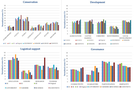
Figure 2.
Final normalized scores for iterations 1, 2, and 3 (it1, it2, it3), original global solution (ORIGINAL) and original scores per dimension (conservation, development, logistical support, and governance) assessed by GOVERNMENT (GOVERNMENT), farmers (FARMERS), businesspersons (BUSINESS), and scientists (SCIENTISTS) groups approached at the global level.
Despite producing sometimes unacceptable solutions, the model provides information that can be used to find the most consensual solutions among groups or participants. Moreover, the model permits to fit the bounded parameters to avoid unacceptable solutions. This might be necessary when preferences are very polarized in a few criteria and the model compensates very strongly one of the less conflictive criteria, when it is necessary to increase the minimum () until an acceptable relative contribution regarding the most conflictive criteria over the other is observed. As an example, it was necessary to increase the parameter to obtain a minimally acceptable solution for research, one of the most conflictive criteria. For this reason, the reduction of conflict is less important in this case than in the other MO, when restrictions are stronger, although the solution obtained is acceptable in iteration 1.
Figure 3 shows the variation in CI for the three iterations per MO in each dimension, where the reduction of the strongest conflicts regarding the most conflictive criteria and the most restrictive iteration is clearly visible.
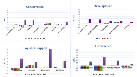
Figure 3.
Changes in Conflict Index in iterations 1, 2, and 3 (Cit1, Cit2, Cit3) vs. Conflict Index (%) by management objective (MO) and dimension.
5.2. Intergroup Conflict Analysis
Intergroup pairwise conflicts analysis (Figure 4) identified the highest levels of conflicts in the domain of conservation for fauna and flora to occur between government and the other groups and between scientists and farmers and businesspersons, and for wildfire between scientists and the other groups. Regarding logistical support, for education and research scientists and farmers were the most conflictive groups. For agriculture and cattle raising (development), the most conflictive groups were scientists and farmers once again. Finally, in the governance domain, guarantees was the most conflictive MO between all the groups, and participation was the most conflictive between farmers and businesspersons and government. Farmers had also some conflicts with businesspersons and scientists regarding connectivity.
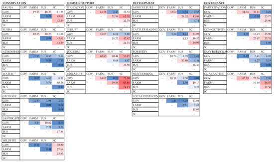
Figure 4.
Pairwise conflicts between pairs of stakeholder groups: Government (GOV), farmers (FARM), businesspersons (BUS), and scientist (SC). In addition to scores, level of conflict is highlighted by a color gradient from dark red (high level of conflict) and dark blue (low level). Results are normalized (percentage) scores obtained applying Equation (13).
Reducing the conflict index scores at the intergroup level was more difficult than at the global level (Figure 5). The comparison of final scores for each iteration, original global solutions and original scores assessed by each stakeholder group (Figure 5) showed that the highest intergroup divergences were for fauna and flora (scientists-businesspersons), and education and research (farmers-scientists). The model provided a smoother solution minimizing the maximum divergent assessments between the most conflictive groups. There are two noticeable effects: (1) as constraints are relaxed, the intergroup solution tended towards the solution of the most discrepant group; and (2) the model compensates the assessments between the most conflictive groups in each dimension. In these cases, one group assessed one MO much better than the others. As an example, when the model provided a solution higher than the original global solution for fauna, at the same time it provided a solution lower than the original solution for Flora. Similarly, in logistical support, another dimension with strong intergroup divergences, the model provided a solution lower and higher than the original for education and for research, respectively. This means that decisions regarding the most conflictive criteria and stakeholders can be balanced between them, making it easier to find acceptable solutions by the most conflictive groups. On the other hand, when the number of analyzed criteria is small and there are simultaneously criteria generating strong conflicts and criteria not generating any conflicts, the model shares the surplus of conflict towards the latter. This is the case of Guarantees and Simplicity in the governance dimension. Guarantees presented strong conflicts between all the groups, except between scientists and government, while simplicity did not present any conflict between groups. The model has a very strong effect on these criteria, providing scores much lower and higher than the minimum tolerable assessment (Table 3). This provides an extraordinarily wide margin to work on consensual solutions.
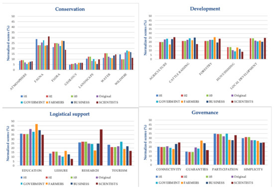
Figure 5.
Final normalized scores for iterations 1, 2 and 3 (it1, it2, it3), original global solution and original scores assessed by government, farmer, businessperson, and scientist groups approached at the intergroup level.
Table 3.
Original global solution (Os), consensual global solution and consensual intergroup solution by iteration it1, it2 and it3 normalized scores and rankings. Green and red colors indicate values that are above the upper and below the lower tolerance interval limits, respectively.
Figure 6, Figure 7 and Figure 8 show the improvement of CI relative to each MO based on Equation (13). The application of the model at the intergroup level resulted in a substantial reduction of CI in the most conflictive MO. As constraints are relaxed and the bounded parameter interval becomes wider, the reduction in CI between the most conflictive groups becomes more evident. For this reason, the colors expressing a reduction of CI in iteration 3 (Figure 8) are more intense than colors expressing a reduction of CI in iteration 1 (Figure 6). For logistical support, development and governance, the higher reductions of conflicts were found in education (farmers-government and scientists), agriculture (farmers-scientists), and guarantees (farmers-government and scientists), in all the iterations. For nature conservation, when constraints were tight, the reduction of conflicts was distributed between wildfire, water, flora and fauna, but when constraints were relaxed, the reduction of CI was mostly on fauna (scientists with farmers and businesspersons) and wildfire (scientists with government and farmers).
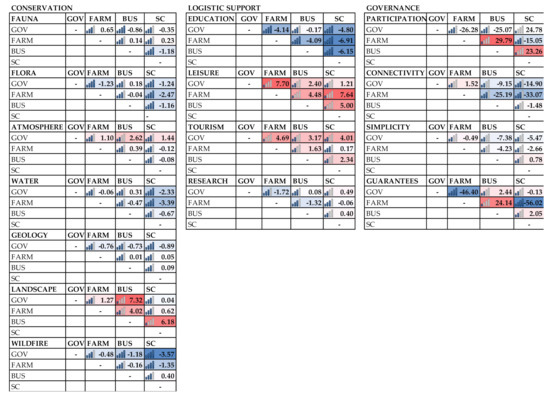
Figure 6.
Changes of intergroup Conflict Index (CI) by Management Objective (MO) and pairs of groups resulting from iteration 1. In addition to scores, level of conflict is highlighted by a color gradient from dark red (high level of conflict) and dark blue (low level).
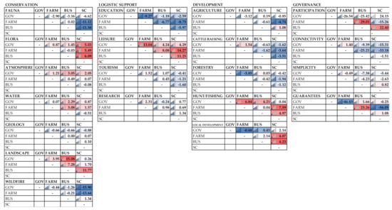
Figure 7.
Changes of intergroup Conflict Index (CI) by management objective (MO) and pair of groups resulting from iteration 2. In addition to scores, level of conflict is highlighted by a color gradient from dark red (high level of conflict) and dark blue (low level).
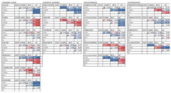
Figure 8.
Changes of intergroup Conflict Index (CI) by management objective (MO) and pair of groups resulting from iteration 3. In addition to scores, level of conflict is highlighted by a color gradient from dark red (high level of conflict) and dark blue (low level).
Moreover, the reduction in intergroup conflict scores, indicated by an increasing of opposite colors (red-blue vs. blue-red) over the original intergroup conflicts (Figure 5), showed that the model acts more intensively over the highest levels of conflicts and groups, compensating with the lower levels of conflicts and groups in order to achieve the least conflictive solution.
5.3. Compared Results
The model, both at the global and the intergroup level (Table 3), provided acceptable consensual solutions for all MO with strong restrictions regarding the bounded parameters (iteration 1), except for MO related to conservation. This is because, when the number of comparisons and restrictions increases, an optimal solution is more difficult to find. Nevertheless, the model provided useful information to guide negotiation processes. Atmosphere, water, geology and landscape criteria have slack to reduce their value without compromising the consensual solution towards the most conflictive criteria.
The MO related to the logistical support provided a robust prioritization, stressing the relevance of the education objective over the others, although the assessed weight assigned to this MO was reduced in order to compensate for the other criteria. Despite that, its position in the original ranking was maintained.
The development objectives were the less conflictive of all. For this reason, when constraints were stronger (iteration 1) the model could not find a feasible/optimal solution. However, when the bounded parameters were relaxed, the model provided an optimal and solid solution, although the global and intergroup conflict ranking positions changed in relation to the original ranking. This instability in rankings is due to the short distances between the relative importance of each criterion.
The most consensual solution suggests prioritizing Fauna and Flora objectives within the conservation dimension, education within logistical support, local development and agriculture within development, and participation within governance. Regarding the MO in governance, the model provided an acceptable solution in the first iteration. However, the most conflictive criteria (guarantees) assessed the minimum tolerable value. When the bounded parameters were relaxed, the assessment of guarantees decreased. That means that this MO could be problematic and maybe this score should be negotiated with simplicity which changes more significantly with the iterations. In this case, the ranking was stable in all the iterations and levels.
6. Discussion
Contemporary forest management and policy require flexible models to integrate various hierarchical levels, strategic and tactical, within a multi-criteria context [71]. In protected areas, complexity in management and decision-making increases with conflicts generated by limitations and use restrictions, mainly between local owners and governments, and with the complexity of governance in these areas. Despite linear programming models having been useful to find optimal management strategies in this context, addressing complex problems with multiple and conflicting objectives in planning can became an exhausting challenge that is not always met. Sometimes, entrenched conflicts related to management and prioritization of socio-economic and conservation goals make it impossible to find an optimal solution from a rigid approach. Participatory processes assume these limitations and provide transparency to decision-making processes and enhance knowledge and empathy by sharing different perspectives.
In this paper we propose a MINMAX linear programming model with a flexibility component that, through a sensitivity analysis, provides insight to guide negotiation processes to achieve consensual solutions. The application of the model to the Meseta Ibérica Biosphere Reserve allowed the identification and modelling of the preferences of four stakeholders’ groups, some of them with conflicting perspectives on management objectives. Additionally, the model allowed the identification of trade-offs between conflict reduction and the constraints related to the relative contribution of each management objective towards the others.
The application of the model highlighted operational issues that are very relevant when dealing with conflicts and allowed the suggestion of some general recommendations. When the number of criteria under comparison increases, the optimal solution is more unstable but more flexible and it is more difficult that it respects the tolerance interval. That means that it is recommendable to control the number of criteria in use. The model runs well when there are strong conflicts but when the assessments are distributed homogeneously over all the stakeholders groups (low standard deviation), it requires a wider width of the bounded parameter interval to find an optimal solution. Moreover, wider intervals result in rankings different from those obtained from the original CI due to the short distances between criteria. When there is a low number of criteria to compare and high levels of conflicts centered in few criteria, the model could not find an optimal and acceptable solution because it penalizes excessively the most conflictive criteria. In these cases, it is particularly important to observe the behavior of criteria when the constraints are relaxed. The continuous increasing of the scores of the criteria that are above the tolerance interval indicates that these criteria can be potential donors of values which does not compromise consensuses. All the recommendations above are essential not just in designing participatory processes but also to guide stakeholder interaction in actual reserve governance.
It is important to remark that the conflict analysis was focused exclusively on the criteria included in each group. When the analysis comprised a wider hierarchical structure, the relative importance of each MO and the relative conflicts varied. As an example, the MO related to development did not present important conflicts within this dimension, but when compared with the criteria of the other groups at a wider level, strong conflicts were found [7]. In our study, the aim was to analyze the application of a new model to find the least conflictive solutions and for this reason the focus was the MO in each dimension. However, to define a complete map of conflicts in a conservation area, this analysis should be undertaken in all the hierarchical levels of the planning structure of that area, connecting all the dimensions and sub-dimensions. In this sense, the main limitation of this model is related to the integrated analysis when the number of criteria increases.
The analysis of intergroup conflicts identified two particularly sensitive groups: Scientists and farmers. Although the conflicts regarding the objectives included in each group were not very important and the rankings were stable in the majority of the dimensions, it was possible to observe a polarization of preferences between scientists and government vs. farmers and businesspersons. This occurs in a high number of protected sites. Studies (e.g., [72,73]) found strong divergences between government and other stakeholder groups regarding power and perceptions of protected area-community conflicts in nine European countries and China, respectively. Traditionally, these issues have been discussed by the Theory of the Commons [74], which is based on the idea that humans cannot efficiently manage resources without market value, such as some natural resources, concluding that their depletion is inevitable. However, other authors, such as [75], provided an alternative approach based on the Theory of Collective Action, supported by the idea that local people pursue conservation of natural resources because these provide their support and when institutions and governance systems have a minimum of quality, local communities can organize themselves in order to preserve these natural resources. In this sense, [76] highlighted that while increasing stakeholder involvement does not necessarily ensure conservation success, increasing trust between stakeholders can increase conservation success. In this line, the identification and understanding of biodiversity related conflicts is paramount to conservation. Usually, the major conflicts in protected areas are structural conflicts, associated to institutional fails and demographic problems, such as weak law enforcement, absence of conflict management mechanisms, land litigation, and demographic changes [29]. In the case of Meseta Ibérica, when stakeholders were asked about the four analyzed dimensions from a wider perspective in [7], the preferences of farmers and businesspersons were related, firstly, with conservation objectives. They assigned less relative relevance to this dimension than scientists or government, but the result was robust. In our research, when preferences regarding the management objectives included in the conservation dimension were analyzed more in-depth, fauna and flora were also the most preferred by local stakeholders, although they were the most conflictive criteria.
Despite these preferences, often the designation of a territory as conservation area generates opposing reactions from local communities. Criminal actions, such as deliberate fire setting or poisoning of wild animals, are induced by local people in areas with high levels of conflicts. For example, [3] showed that the perceived risk of livestock predation by wolves was the main motivation for poisoning in a protected area in the Cantabrian Mountains (Spain) and that the existence of protected areas was positively correlated to this illegal practice, while socioeconomic factors were not so influent. This could be explained (never justified) by a feeling or perception of insecurity or uncertainty of local people related to a lack of involvement of these communities in decision-making processes regarding land planning and management. Dialogue, information and participation of private owners and other stakeholders in decision-making processes could solve partially some institutional problems that are the source of structural conflicts in conservation areas, increasing the legitimacy of conservation plans [77]. In this sense, participatory MCDM tools should contribute to integrate the three basic ethic principles regarding sustainability (prudence, justice and good life [78]) in the planning of conservation areas worldwide.
7. Conclusions
The multi-criteria model based on linear programming proposed provides an aggregation process that can improve and guide decision-making processes towards the most consensual/least conflictive solutions. Moreover, it permits to generate information regarding the behavior of conflicts and the development of a sensitivity analysis in order to guide negotiations along decision-making processes. This can be oriented at global and intergroup levels, modelling distances to the global solution or distances between the most conflictive groups for each MO.
The application of the model in the Meseta Ibérica Biosphere Reserve resulted in lower global conflictive weights for each MO by dimension and identified the most relevant conflicts and the most conflictive groups. The most sensitive groups were farmers and scientists and the effort of negotiation processes should be oriented towards these groups, particularly regarding fauna and flora, research, guarantees, and agriculture objectives.
In the Meseta Ibérica Biosphere Reserve, the analysis regarding conflicts involved in each dimension showed that:
- Conservation: The highest levels of conflicts were related to fauna and flora between businesspersons and farmers and government and scientists. atmosphere, landscape and water can be used as compensating criteria in order to get a consensual solution.
- Logistical support: The highest levels of conflicts were observed in education and research and the most sensitive group was scientists. The trade-offs between education and research and between leisure and tourism seem to be able to guide compensations towards a more consensual solution.
- Development: No major conflicts were found in this dimension, although the intergroup conflict approach identified conflicts between farmers and other groups regarding agriculture, and with businesspersons regarding forestry. Moreover, scientists diverged from the other groups regarding cattle raising.
- Governance: The most sensitive objective was guarantees. This objective is a strong source of conflicts between farmers and scientists, and government. The results provided by the model suggest negotiations towards the compensation by simplicity to achieve consensuses.
The relevance of conflicts among stakeholders’ groups emphasizes the need for the development of tools and models that promote the participation of all the stakeholder groups of an area, including private owners, and the need to develop models that deal with conflicts between all actors.
The presented model contributes to planning in protected areas by identifying the existing strongest conflicts and by allowing to assign relative importance to management objectives, smoothing the most conflictive cases. The method is posed following an optimization approach complemented with a participative sensitivity analysis that can be developed by stakeholders and experts. For this reason, this study provides a methodological tool to be applied in solving decision problems in conservation areas supporting collaborative planning with the involvement of local stakeholders. Conflict analysis can be used in practice to better understand the nature of divergences between stakeholders and establish the basis of a common framework of discussion and learning regarding issues that are key to meet aims and goals of conservation areas. The identification of conflicts and information on where, how and between whom they exist is fundamental in efficient negotiation processes to achieve consensual or acceptable solutions by all the groups with interests in the same territory. Moreover, when governments are involved this framework can be a negotiation basis for the development of minimum conflicts/rules and laws in conservation areas.
At present, the availability of tools to solve conflicts related to planning in protected areas is limited, although conflicts sometimes are so strong that carry out negative consequences at the institutional level, such as blocking decision-making processes, and social and environmental negative consequences that can jeopardize conservation efforts. It is therefore necessary to develop improved models to manage conflicts combining flexible and rigorous approaches, using participative methods and optimization models in an integrated way.
The main limitations for the application of this model are related to the rigidity and slowness of bureaucracy and the lack of coordination and communication between government levels in some conservation sites. The inflexibility of some administrative processes is a serious obstacle to the development of agile processes and to the involvement of non-institutional groups in decision processes. It is therefore recommended to make efforts to review such mechanisms to promote the application of participative tools that contribute to the good governance of conservation areas.
Supplementary Materials
The following are available online at https://www.mdpi.com/2071-1050/13/4/1959/s1. Supplementary Material 1. Description of the management objectives analyzed in the Meseta Ibérica Biosphere Reserve. Supplementary Material 2. Original global solution, stakeholder group assessments and standard deviation. Supplementary Material 3. Example for the application of the model to Dimension Conservation-Iteration 1 and Global Distance approach.
Author Contributions
Two authors have contributed to this research. Conceptualization, methodology, and writing—original draft preparation: M.d.C.-P.; investigation and formal analysis: M.d.C.-P. and J.C.A.; writing—review and editing, and funding acquisition: J.C.A. All authors have read and agreed to the published version of the manuscript.
Funding
This research was partially funded by FCT/MCTES through project grant UIDB/00690/2020.
Institutional Review Board Statement
Not applicable.
Informed Consent Statement
Not applicable.
Data Availability Statement
Not applicable.
Acknowledgments
The authors would like to acknowledge the support of Victor Martin with the software and the comments and recommendations of four reviewers.
Conflicts of Interest
The authors declare no conflict of interest.
References
- Buijs, A.; Hovardas, T.; Figari, H.; Castro, P.; Devine-Wright, P.; Fischer, A.; Mouro, C.; Selge, S. Understanding people’s ideas on natural resource management: Research on social representations of nature. Soc. Nat. Resour. 2012, 25, 1167–1181. [Google Scholar] [CrossRef]
- De Castro-Pardo, M.; Pérez-Rodríguez, F.; Martín-Martín, J.M.; Azevedo, J.C. Planning for Democracy in Protected Rural Areas: Application of a Voting Method in a Spanish-Portuguese Reserve. Land 2019, 8, 145. [Google Scholar] [CrossRef]
- Mateo-Tomás, P.; Olea, P.P.; Sánchez-Barbudo, I.S.; Mateo, R. Alleviating human–wildlife conflicts: Identifying the causes and mapping the risk of illegal poisoning of wild fauna. J. Appl. Ecol. 2012, 49, 376–385. [Google Scholar] [CrossRef]
- Partidario, M.R.; Monteiro, M.B. Strategic environmental assessment effectiveness in Portugal. Impact Assess. Proj. Apprais. 2019, 37, 247–265. [Google Scholar] [CrossRef]
- López-Hoffman, L.; Varady, R.G.; Flessa, K.W.; Balvanera, P. Ecosystem services across borders: A framework for transboundary conservation policy. Front. Ecol. Environ. 2010, 8, 84–91. [Google Scholar] [CrossRef]
- Orenstein, D.E.; Groner, E. In the eye of the stakeholder: Changes in perceptions of ecosystem services across an international border. Ecosyst. Serv. 2014, 8, 185–196. [Google Scholar] [CrossRef]
- De Castro-Pardo, M.; Pérez-Rodríguez, F.; Martín-Martín, J.M.; Azevedo, J.C. Modelling stakeholders’ preferences to pinpoint conflicts in the planning of transboundary protected areas. Land Use Policy 2019, 89, 104233. [Google Scholar] [CrossRef]
- Marsden, K.; Hovardas, T. EU Rural Development Policy and the management of conflictual species: The case of large carnivores. Biol. Conserv. 2020, 243, 108464. [Google Scholar] [CrossRef]
- Harrison, H.L.; Loring, P.A. Seeing beneath disputes: A transdisciplinary framework for diagnosing complex conservation conflicts. Biol. Conserv. 2020, 248, 108670. [Google Scholar] [CrossRef]
- Jelokhani-Niaraki, M. Collaborative spatial multicriteria evaluation: A review and directions for future research. Int. J. Geogr. Inf. Sci. 2020, 35, 9–42. [Google Scholar] [CrossRef]
- De Oliveira, A.R.; Partidário, M. You see what I mean? A review of visual tools for inclusive public participation in EIA decision-making processes. Environ. Impact Assess. Rev. 2020, 83, 106413. [Google Scholar] [CrossRef]
- Rocchi, L.; Cortina, C.; Paolotti, L.; Boggia, A. Recreation vs conservation in Natura 2000 sites: A spatial multicriteria approach analysis. Land Use Policy 2020, 99, 105094. [Google Scholar] [CrossRef]
- Kazana, V.; Kazaklis, A.; Raptis, D.; Stamatiou, C. A combined multi-criteria approach to assess forest management sustainability: An application to the forests of Eastern Macedonia & Thrace Region in Greece. Ann. Oper. Res. 2020, 294, 321–343. [Google Scholar]
- Sumida, S.S.; Valente, R.A. Multicriterial evaluation in the definition of protected areas at the Piedade municipality, SP. Revista Árvore 2019, 43, e430307. [Google Scholar] [CrossRef]
- Cruz Salomãoa, C.D.S.; de Souza Paula, L.G.; Timbó Elmiro, M.A. Use of multicriteria analysis to define priority areas for reforestation in the Piranga River Basin, MG, Brazil. Sustain. Debate 2020, 11, 95–120. [Google Scholar]
- Díaz-Balteiro, L.; Alfranca, O.; González-Pachón, J.; Romero, C. Ranking of industrial forest plantations in terms of sustainability: A multicriteria approach. J. Environ. Manag. 2016, 180, 123–132. [Google Scholar] [CrossRef]
- Eggers, J.; Holmgren, S.; Nordström, E.M.; Lämås, T.; Lind, T.; Öhman, K. Balancing different forest values: Evaluation of forest management scenarios in a multi-criteria decision analysis framework. For. Policy Econ. 2019, 103, 55–69. [Google Scholar] [CrossRef]
- Marques, M.; Oliveira, M.; Borges, J.G. An approach to assess actors’ preferences and social learning to enhance participatory forest management planning. Trees For. People 2020, 2, 100026. [Google Scholar] [CrossRef]
- Sironen, S.; Primmer, E.; Leskinen, P.; Similä, J.; Punttila, P. Context sensitive policy instruments: A multi-criteria decision analysis for safeguarding forest habitats in Southwestern Finland. Land Use Policy 2020, 92, 104460. [Google Scholar] [CrossRef]
- Tasse, M.; Deliri, H.K.; Khafaki, S.B.; Naderloo, L.; Hassan, M.; Ravesh, S. Forest conservation management based on fuzzy multi-criteria decision-making method. Forestist 2020, 70, 122–132. [Google Scholar] [CrossRef]
- Sturiale, L.; Scuderi, A.; Timpanaro, G.; Matarazzo, B. Sustainable Use and Conservation of the Environmental Resources of the Etna Park (UNESCO Heritage): Evaluation Model Supporting Sustainable Local Development Strategies. Sustainability 2020, 12, 1453. [Google Scholar] [CrossRef]
- Portillo, L.A.F.; Nekhay, O.; Mohedano, L.E. Use of the ANP methodology to prioritize rural development strategies under the LEADER approach in protected areas. The case of Lagodekhi, Georgia. Land Use Policy 2019, 88, 104121. [Google Scholar] [CrossRef]
- Kukkonen, M.O.; Tammi, I. Systematic reassessment of Laos’ protected area network. Biol. Conserv. 2019, 229, 142–151. [Google Scholar] [CrossRef]
- Huber, P.; Hujala, T.; Kurttila, M.; Wolfslehner, B.; Vacik, H. Application of multi criteria analysis methods for a participatory assessment of non-wood forest products in two European case studies. For. Policy Econ. 2019, 103, 103–111. [Google Scholar] [CrossRef]
- Martínez-López, J.; Teixeira, H.; Morgado, M.; Almagro, M.; Sousa, A.I.; Villa, F.; Lillebø, A.I. Participatory coastal management through elicitation of ecosystem service preferences and modelling driven by “coastal squeeze”. Sci. Total Environ. 2019, 652, 1113–1128. [Google Scholar] [CrossRef] [PubMed]
- Saarikoski, H.; Mustajoki, J.; Hjerppe, T.; Aapala, K. Participatory multi-criteria decision analysis in valuing peatland ecosystem services—Trade-offs related to peat extraction vs. pristine peatlands in Southern Finland. Ecol. Econ. 2019, 162, 17–28. [Google Scholar] [CrossRef]
- De Castro-Pardo, M.; Fernández Martínez, P.; Guaita Martínez, J.M.; Martín Martín, J.M. Modelling Natural Capital: A Proposal for a Mixed Multi-criteria Approach to Assign Management Priorities to Ecosystem Services. Contemp. Econ. 2020, 14, 22–38. [Google Scholar] [CrossRef]
- Fernández Martínez, P.; de Castro-Pardo, M.; Martín Barroso, V.; Azevedo, J.C. Assessing Sustainable Rural Development Based on Ecosystem Services Vulnerability. Land 2020, 9, 222. [Google Scholar] [CrossRef]
- Oduro-Ofori, E.; Ocloo, K.A.; Peprah, C.; Effah, G. Assessing natural resource use conflicts in the Kogyae Strict Nature Reserve, Ghana. Environ. Nat. Resour. Res. 2015, 5, 56. [Google Scholar] [CrossRef]
- Schirpke, U.; Scolozzi, R.; Dean, G.; Haller, A.; Jäger, H.; Kister, J.; Kóvacs, B.; Sarmiento, F.O.; Sattler, B.; Schleyer, C. Cultural ecosystem services in mountain regions: Conceptualising conflicts among users and limitations of use. Ecosyst. Serv. 2020, 46, 101210. [Google Scholar] [CrossRef]
- Jäger, H.; Schirpke, U.; Tappeiner, U. Assessing conflicts between winter recreational activities and grouse species. J. Environ. Manag. 2020, 276, 111194. [Google Scholar] [CrossRef]
- Franklin, O.; Krasovskiy, A.; Kraxner, F.; Platov, A.; Shchepashchenko, D.; Leduc, S.; Mattsson, B. Moose or spruce: A systems analysis model for managing conflicts between moose and forestry in Sweden. BioRxiv 2020. [Google Scholar] [CrossRef]
- Hovardas, T. A methodology for stakeholder analysis, consultation and engagement in large carnivore conservation and management. In Large Carnivore Conservation and Management: Human Dimensions; Routledge: London, UK, 2018; p. 11. [Google Scholar]
- Verschueren, S.; Briers-Louw, W.D.; Torres-Uribe, C.; Siyaya, A.; Marker, L. Assessing human conflicts with carnivores in Namibia’s eastern communal conservancies. Hum. Dimens. Wildl. 2020. [Google Scholar] [CrossRef]
- Morea, J.P. A framework for improving the management of protected areas from a social perspective: The case of Bahía de San Antonio Protected Natural Area, Argentina. Land Use Policy 2019, 87, 104044. [Google Scholar] [CrossRef]
- Marques, M.; Juerges, N.; Borges, J.G. Appraisal framework for actor interest and power analysis in forest management-Insights from Northern Portugal. For. Policy Econ. 2020, 111, 102049. [Google Scholar] [CrossRef]
- Yuxi, Z.; Linsheng, Z. Identifying conflicts tendency between nature-based tourism development and ecological protection in China. Ecol. Indic. 2020, 109, 105791. [Google Scholar] [CrossRef]
- Skjeggedal, T.; Flemsaeter, F.; Gundersen, V. Land use planning in disputed mountain areas: Conflicting interests and common arenas. J. Environ. Plan. Manag. 2020. [Google Scholar] [CrossRef]
- Tuda, A.O.; Rodwell, L.D.; Stevens, T. Conflict management in Mombasa Marine National Park and Reserve, Kenya: A spatial multicriteria approach. In Proceedings of the Workshop on a Regional Perspective on MPAs in the Western Indian Ocean Rodrigues Island, Rodrigues, Mauritius, 9–14 May 2007; pp. 63–72. [Google Scholar]
- Cieślak, I. Identification of areas exposed to land use conflict with the use of multiple-criteria decision-making methods. Land Use Policy 2019, 89, 104225. [Google Scholar] [CrossRef]
- Redpath, S.M.; Keane, A.; Andrén, H.; Baynham-Herd, Z.; Bunnefeld, N.; Duthie, A.B.; Pollard, C.R. Games as tools to address conservation conflicts. Trends Ecol. Evol. 2018, 33, 415–426. [Google Scholar] [CrossRef]
- Mukherjee, N.; Zabala, A.; Huge, J.; Nyumba, T.O.; Adem Esmail, B.; Sutherland, W.J. Comparison of techniques for eliciting views and judgements in decision-making. Methods Ecol. Evol. 2018, 9, 54–63. [Google Scholar] [CrossRef]
- Driscoll, D.A.; Bode, M.; Bradstock, R.A.; Keith, D.A.; Penman, T.D.; Price, O.F. Resolving future fire management conflicts using multicriteria decision making. Conserv. Biol. 2016, 30, 196–205. [Google Scholar] [CrossRef] [PubMed]
- Liu, J.; Fang, S.C.; Chen, H. Multiplicative data envelopment analysis cross-efficiency and stochastic weight space acceptability analysis for group decision making with interval multiplicative preference relations. Inf. Sci. 2020, 514, 319–332. [Google Scholar] [CrossRef]
- De Oliveira Silva, L.G.; de Almeida-Filho, A.T. A multicriteria approach for analysis of conflicts in evidence theory. Inf. Sci. 2016, 346, 275–285. [Google Scholar] [CrossRef]
- Frini, A.; Amor, S.B. MUPOM: A multi-criteria multi-period outranking method for decision-making in sustainable development context. Environ. Impact Assess. Rev. 2019, 76, 10–25. [Google Scholar] [CrossRef]
- González-Pachón, J.; Romero, C. Distance-based consensus methods: A goal programming approach. Omega 1999, 27, 341–347. [Google Scholar] [CrossRef]
- González-Pachón, J.; Diaz-Balteiro, L.; Romero, C. A multi-criteria approach for assigning weights in voting systems. Soft Comput. 2019, 23, 8181–8186. [Google Scholar] [CrossRef]
- Young, J.C.; Searle, K.; Butler, A.; Simmons, P.; Watt, A.D.; Jordan, A. The role of trust in the resolution of conservation conflicts. Biol. Conserv. 2016, 195, 196–202. [Google Scholar] [CrossRef]
- Grêt-Regamey, A.; Sirén, E.; Brunner, S.H.; Weibel, B. Review of decision support tools to operationalize the ecosystem services concept. Ecosyst. Serv. 2017, 26, 306–315. [Google Scholar] [CrossRef]
- Schultz, L.; Lundholm, C. Learning for resilience? Exploring learning opportunities in biosphere reserves. Environ. Educ. Res. 2010, 16, 645–663. [Google Scholar] [CrossRef]
- Ferreira, A.F.; Zimmermann, H.; Santos, R.; von Wehrden, H. Biosphere Reserves’ Management Effectiveness—A Systematic Literature Review and a Research Agenda. Sustainability 2020, 12, 5497. [Google Scholar] [CrossRef]
- De Castro-Pardo, M.; Urios, V. A critical review of multi-criteria decision making in protected areas. Econ. Agrar. Recur. Nat. Agric. Resour. Econ. 2017, 16, 89–109. [Google Scholar] [CrossRef][Green Version]
- Castro, J.; de Figueiredo, T.; Fonseca, F.; Castro, J.P.; Nobre, S.; Pires, L.C. Montesinho Natural Park: General description and natural values. In Natural Heritage from East to West; Springer: Berlin/Heidelberg, Germany, 2010; pp. 119–132. [Google Scholar]
- Sil, Â.; Fernandes, P.M.; Rodrigues, A.P.; Alonso, J.M.; Honrado, J.P.; Perera, A.; Azevedo, J.C. Farmland abandonment decreases the fire regulation capacity and the fire protection ecosystem service in mountain landscapes. Ecosyst. Serv. 2019, 36, 100908. [Google Scholar] [CrossRef]
- ZASNET. 2020. Available online: https://www.biosfera-mesetaiberica.com/es/es/territorio (accessed on 11 November 2020).
- Vasilijević, M.; Zunckel, K.; McKinney, M.; Erg, B.; Schoon, M.; Rosen Michel, T. Transboundary Conservation: A systematic and integrated approach. In Best Practice Protected Area Guidelines Series No. 23; IUCN: Gland, Switzerland, 2015. [Google Scholar]
- Dudley, N. (Ed.) Guidelines for Applying Protected Area Management Categories; IUCN: Gland, Switzerland, 2008. [Google Scholar]
- Plano de Ordenamento do Parque Natural do Douro Internacional. Available online: https://dre.pt/web/guest/pesquisa/-/search/240064/details/normal?q=Plano+de+Ordenamento+do+Parque+Natural+do+Douro+Internacional (accessed on 1 October 2020).
- Plano de Ordenamento do Parque Natural do Montesinho. Available online: https://dre.pt/web/guest/pesquisa/-/search/440076/details/normal?q=Plano+de+Ordenamento+do+Parque+Natural+do+Montesinho (accessed on 1 October 2020).
- Plan de Ordenación de los Recursos Naturales del Lago de Sanabria y alrededores. Available online: http://bocyl.jcyl.es/html/2013/10/02/html/BOCYL-D-02102013-1.do (accessed on 1 October 2020).
- Plan de Ordenación de los Recursos Naturales del Parque Natural Arribes del Duero. Available online: http://bocyl.jcyl.es/html/2001/06/13/html/BOCYL-D-13062001-20.do (accessed on 1 October 2020).
- Marttunen, M.; Lienert, J.; Belton, V. Structuring problems for Multi-Criteria Decision Analysis in practice: A literature review of method combinations. Eur. J. Oper. Res. 2017, 263, 1–17. [Google Scholar] [CrossRef]
- Saaty, T.L. Fundamentals of the analytic hierarchy process. In The Analytic Hierarchy Process in Natural Resource and Environmental Decision Making; Springer: Rotterdam, The Netherlands, 2001; pp. 15–35. [Google Scholar]
- González-Pachón, J.; Romero, C. A method for dealing with inconsistencies in pairwise comparisons. Eur. J. Oper. Res. 2004, 158, 351–361. [Google Scholar] [CrossRef]
- Pang, J.; Liang, J. Evaluation of the results of multi-attribute group decision-making with linguistic information. Omega 2012, 40, 294–301. [Google Scholar] [CrossRef]
- Romero, C. Extended lexicographic goal programming: A unifying approach. Omega 2001, 29, 63–71. [Google Scholar] [CrossRef]
- Wong, Y.H.; Beasley, J.E. Restricting weight flexibility in data envelopment analysis. J. Oper. Res. Soc. 1990, 41, 829–835. [Google Scholar] [CrossRef]
- Cherchye, L.; Moesen, W.; Rogge, N.; Van Puyenbroeck, T. An introduction to ‘benefit of the doubt’composite indicators. Soc. Indic. Res. 2007, 82, 111–145. [Google Scholar] [CrossRef]
- Romero, C. Handbook Critical Issues Goal Programming; Pergamon Press: Oxford, UK, 1991. [Google Scholar]
- Baskent, E.Z.; Borges, J.G.; Kašpar, J.; Tahri, M. A Design for Addressing Multiple Ecosystem Services in Forest Management Planning. Forests 2020, 11, 1108. [Google Scholar] [CrossRef]
- Juerges, N.; Arts, B.; Masiero, M.; Başkent, E.Z.; Borges, J.G.; Brodrechtova, Y.; Pivoriūnas, N. Integrating ecosystem services in power analysis in forest governance: A comparison across nine European countries. For. Policy Econ. 2020, 121, 102317. [Google Scholar] [CrossRef]
- Liu, J.; Ouyang, Z.; Miao, H. Environmental attitudes of stakeholders and their perceptions regarding protected area-community conflicts: A case study in China. J. Environ. Manag. 2010, 91, 2254–2262. [Google Scholar] [CrossRef]
- Hardin, G. The tragedy of the Commons. Science 1968, 162, 1243–1248. [Google Scholar] [PubMed]
- Ostrom, E. Governing the Commons: The Evolution of Institutions for Collective Action; Cambridge University Press: Cambridge, UK, 1990. [Google Scholar]
- Young, J.C.; Jordan, A.; Searle, K.R.; Butler, A.; Chapman, D.S.; Simmons, P.; Watt, A.D. Does stakeholder involvement really benefit biodiversity conservation? Biol. Conserv. 2013, 158, 359–370. [Google Scholar] [CrossRef]
- Paloniemi, R.; Hujala, T.; Rantala, S.; Harlio, A.; Salomaa, A.; Primmer, E.; Arponen, A. Integrating social and ecological knowledge for targeting voluntary biodiversity conservation. Conserv. Lett. 2018, 11, e12340. [Google Scholar] [CrossRef]
- Bieling, C.; Eser, U.; Plieninger, T. Towards a better understanding of values in sustainability transformations: Ethical perspectives on landscape stewardship. Ecosyst. People 2020, 16, 188–196. [Google Scholar] [CrossRef]


Publisher’s Note: MDPI stays neutral with regard to jurisdictional claims in published maps and institutional affiliations. |
© 2021 by the authors. Licensee MDPI, Basel, Switzerland. This article is an open access article distributed under the terms and conditions of the Creative Commons Attribution (CC BY) license (http://creativecommons.org/licenses/by/4.0/).