4.3.1. Spatial–Temporal Changes of Agricultural and Demographic Transformation of Settlements in Rural Areas
The effect of urbanization in modern conditions is absorbed by even the most remote villages and, thus, an increasing amount of rural population accepts the values of urban areas [
34]. Due to the acceptance of new values, there is a depopulation of rural areas and a change in the organization of agricultural production. In suburban settlements, the dynamics of urbanization are the most intense, and rural–urban conflicts due to land-use changes are most pronounced. Different social groups adapt valuation standards to their needs, which is why traditional cultural landscapes change frequently [
71]. The basic characteristics of modern changes in rural–urban relations and connections, defined through the processes of polarization, diffusivity, accessibility, and mobility [
72], result in a pronounced migration of the population in the studied area. The analysis of the basic characteristics of the urban system in Serbia [
73] and different demographic characteristics of the rural areas [
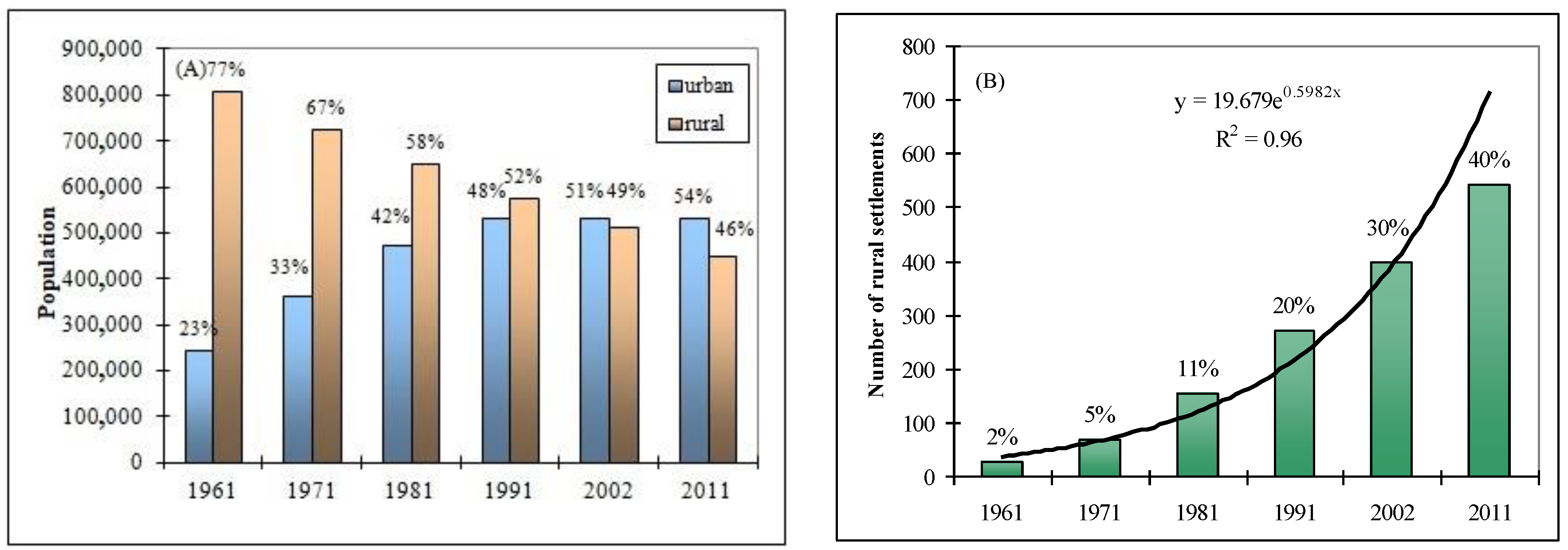
30] has emphasized the unbalanced spatial and regional development. These characteristics are very pronounced in the area of the Južna Morava river basin. According to 1961 Census, approximately a quarter of the total population (23%) lived in urban areas and approximately 77% of the active population lived in rural settlements. Over five decades, urbanity had increased to 54% by 2011, while the share of the rural population decreased to 46% (
Figure 4A). The long-term policy of marginalizing rural areas led to a gradual aging and disappearance of the rural settlements; therefore, many households and agricultural activities have died out. The demographic aging of the labor force engaged in agriculture has had negative implications on the agricultural production itself, such that this rural labor force becomes a limiting factor in agricultural development [
74]. The process of extinction of rural settlements and the drastic decline in the rural population have lasted for several decades. The number of rural settlements with less than 100 inhabitants has been growing exponentially. According to the last census (in 2011), 40% of rural settlements had fewer than 100 inhabitants, while that in 1961 was only 2% (
Figure 4B).
As a consequence of long-term negative development tendencies, the rural settlements in the Južna Morava basin have undergone major transformations, in terms of the demographic and agro-geographical contexts. The typology of changes in the dynamics of population, agricultural areas, and arable land in the settlements of the Južna Morava basin is shown in
Figure 5. Based on the presented methodology in the study area, the four basic types of settlements were defined.
The progressive type is characteristic of settlements in which the number of inhabitants, agricultural area, and arable land did not decrease, or where the decrease was significantly below the regional average. Progressive type of population change (PT
P) occurred in 131 settlements (10%), while progressive type of change in agricultural areas (PT
AgL) was present in 309 settlements (23%) and progressive type of arable land (PT
ArL) occurred in 203 settlements (15%). The progressive type of change was spatially located in the plain–valley part of the basin, along the main highway route in the peri-urban zone and, to a significant extent, the settlements with less pronounced processes of depopulation and deagrarization coincided. Multifunctional land-use in suburban areas conditions more efficient agricultural production and optimal market access [
75]. Therefore, the intensive action of urbanization initiated the reaction of the peripheral rural area, in the form of increased attractiveness of settlement.
The stagnant type was also spatially located in the peri-urban belt, next to the progressive-type settlements. This type of change was characterized by a decrease in the number of inhabitants, agricultural area, and arable land, in proportion to the regional average. The stagnant type of population change (ST
P) occurred in 275 settlements (20%), the stagnant type of change in agricultural land (ST
AgL) occurred in 312 settlements (23%), and the stagnant type of arable land change (ST
ArL) occurred in 330 settlements (24%). Unlike the part of the peri-urban belt in which settlements of progressive type were located, areas of stagnant type were characterized by a higher degree of fragmentation of holdings, greater diffusion of land-use, and increased urbanization pressure on agricultural land. The higher degree of fragmentation of agricultural holdings can be explained by the sale of part of agricultural plots, due to the high price of land [
76], and the abandonment of agrarian activity in settlements of stagnant type.
The regressive type was characterized by a decrease in the number of inhabitants, agricultural area, and arable land higher than the regional average (i.e., up to the negative average of the Regional share component). Rural settlements of this type were extremely depopulated, while the process of deagrarization was in an advanced stage. In terms of the territorial distribution, settlements of this type were mainly located outside the plain–valley part and outside the peri-urban belt. They were characterized by poor accessibility to the agricultural market and mostly extensive agricultural production. The regressive type of population change (RTP) occurred in 649 settlements (48%), the regressive type of change in agricultural area (RTAgL) occurred in 383 settlements (28%), and the regressive type of arable land change (RTArL) occurred in 417 settlements (30%).
The dominant regressive type describes the situation where value of the net relative change was significantly lower than the negative average of the Regional share component. Rural settlements of this type form a zone which experienced extremely intensive processes of deagrarization, depopulation, and senilization of rural settlements. The dominant regressive type of population change (DRT
P) occurred in 298 settlements (22%), the dominant regressive type of agricultural land change (DRT
AgL) occurred in 349 settlements (26%), and the dominant regressive type of arable land change (DRT
ArL) occurred in 417 settlements (31%). They were spatially located mainly in the peripheral (distinctly hilly and mountainous) belts, in relation to important urban centers. In rural settlements of this type, the elderly population was predominantly represented, which is why there was no labor-intensive agricultural production [
47].
The decrease in the number of inhabitants of rural areas is a consequence of continuous rural–urban migration, reduced fertility, and the decline in the attractiveness of rural settlements due to the increased need for a modern lifestyle among the working population. Land abandonment was most pronounced in marginal mountain or semi-mountainous areas, where agriculture was, until recent decades, traditional or semi-traditional with low input and high human labor intensity. The main factor in reducing agricultural and arable land is not a consequence of systematically organized restructuring of agriculture or the effect of a planned change in the direction of agricultural land-use but, most often, is instead a consequence of the individual decisions of farmers [
77].
4.3.2. Temporal Changes in Transport of Suspended Sediment
Sediment rating curves were obtained for five distinct periods, according to the annual water discharge, sediment load, water discharge, and suspended sediment concentration. All sediment rating curves generally displayed a decreasing trend in all periods (
Figure 6). In
Table 5, the regression coefficient
a had the highest value in the period up to 1980. The decreasing coefficient
a and increasing coefficient
b for SSC in the period after 1980 imply a decreasing sediment supply from the main source area of sediment and an increased erosive power of the river channel. A slightly higher value of the coefficient
a in the sediment rating curve for Qs in the period 2001–2007 can be attributed to the increase in water discharge. Comparing water discharge, the trends of suspended sediment concentration and sediment load were more obvious (
Figure 7); specifically, the mean water discharge in the period 2001–2007 was only 16% lower than in the first decade (1961–1970), while the mean SSC and mean Qs in the same period declined by 77% and 81%, respectively. A similar situation was observed, with respect to the change in maximum suspended sediment concentration and maximum sediment load. The MK test results showed decreasing and significant trends (α = 0.001) for SSC
max and Qs
max (
Figure 3). The mean values of SSC
max and Qs
max in the period 2001–2007 are lower by 87% and 80%, respectively, compared to the first ten years. These results indicate a gradual downward shift, in response to the sediment reductions induced by human activities.
4.3.3. Rural Population, Agricultural Area, and Arable Land as Factors of Decline in Sediment Load
Developed European countries annually “lose” about 1.5% of the rural population [
78], due to which arable land is reduced, the number of farmers decreases, and the structure of production changes. A similar trend was also observed in the territory of the Južna Morava basin. In general, during the study period (from 1961 to 2011), the number of inhabitants decreased by an average of 0.87% per year, while agricultural land decreased by 1.2% and arable land by about 1% per year. During the research period, suspended sediment concentration and sediment load decreased by about 1.5% and 1.8% per year, respectively. The loss of agricultural land is the main feature of the deagrarization process, and the most intensive decrease in the structure of the land was recorded for arable land. The intensity of depopulation and deagrarization [
25] are presented, in terms of different population dynamic type (Tp) settlements (
Figure 8). The process of deagrarization, as an important factor in the transformation of the environment, was most pronounced in rural areas of regressive and dominant regressive type. As can be seen from
Figure 8, the highest intensity of deagrarization (i.e., high and medium-high deagrarization index) with average values of loss of agricultural and arable land of 85% and 89%, respectively, was typical for the predominantly regressive type of settlement (DRTp), for which a high depopulation index also held. Medium-high and medium deagrarization index, with an average reduction of agricultural land by 62% and arable land by 55%, is characteristic of the regressive type of settlement (RTp). Continuous reduction of agricultural area and arable land were also present in settlements of stagnant type (STp), but to a somewhat lesser extent (i.e., medium deagrarization index). The more intensive reduction of agricultural land (42%), in relation to the number of inhabitants (22%) in settlements of stagnant type, was a consequence of the continuous reduction of the agricultural labor force, in response to increased mechanization and periodic participation in agricultural production by the active population employed in other sectors. Even in settlements with a relatively stable or slight increase in population (PTp), there was an evident loss of land fund, which averaged 42% for agricultural land and 28% for arable land.
The decreasing trends of population, agricultural land, and arable land were directly related to the decline of suspended sediment. Statistical interactions between anthropogenic indicators and sediment parameters are described by the regression equation (
Figure 9) and correlation matrix (
Table 6). Correlations between variables were significant at
p < 0.05. The results demonstrated high significance between variables. The values of the correlation coefficients (r) ranged from 0.94 to 0.99. In general, it can be concluded that the statistical analyses showed a strong level of dependence between the decreases in rural population, agricultural land, and arable land, and the decreases of suspended sediment concentration and sediment load.
The rates of decrease in sediment load and water discharge are the result of various human interventions and activities. There have been no systematic long-term measurements or research on the influence of anthropogenic factors on the flow regime in the study area. Some studies have indicated several possibilities [
79,
80]: The long-term acceptance of water from the right tributaries of the Južna Morava into river basins in the territory of Bulgaria; or water extraction and diversion for agricultural irrigation and urban and industrial use. Undoubtedly, the adoption of soil and water conservation measures and engineering structures in the 1960s and 1970s played a certain role in water discharge and sediment reduction [
45]. However, our research showed that the biggest change in the reduction of sediment was reflected by land-use changes. Causal links between industrialization, urbanization, and economic and demographic development reflect the spatial distribution of the population. The socio-economic changes were the most pronounced in the 1970s and 1980s, when the reproductive population immigrated to urban areas [
81]. The complex dynamics of rural–urban migration have resulted in an intensive process of depopulation, continuous fragmentation of rural settlements, structural changes in agricultural production, and changes in arable land-use. Rural settlements in mountainous and peripheral parts of the basin have typical features of traditional agriculture with low labor force engagement, low productivity, and low level of development [
82]. The basic agrarian characteristic of the basin, overall, is the intensive and unplanned reduction of agricultural land. The abandonment of agricultural land affected the reduction of sediment production, and the transition year of sediment load (1984) was also in good agreement with the period of the major demographic and socio-economic changes.


