
Identifying Potential Sites for Artificial Recharge in the Plain Area of the Daqing River Catchment Using GIS-Based Multi-Criteria Analysis


Abstract
:1. Introduction
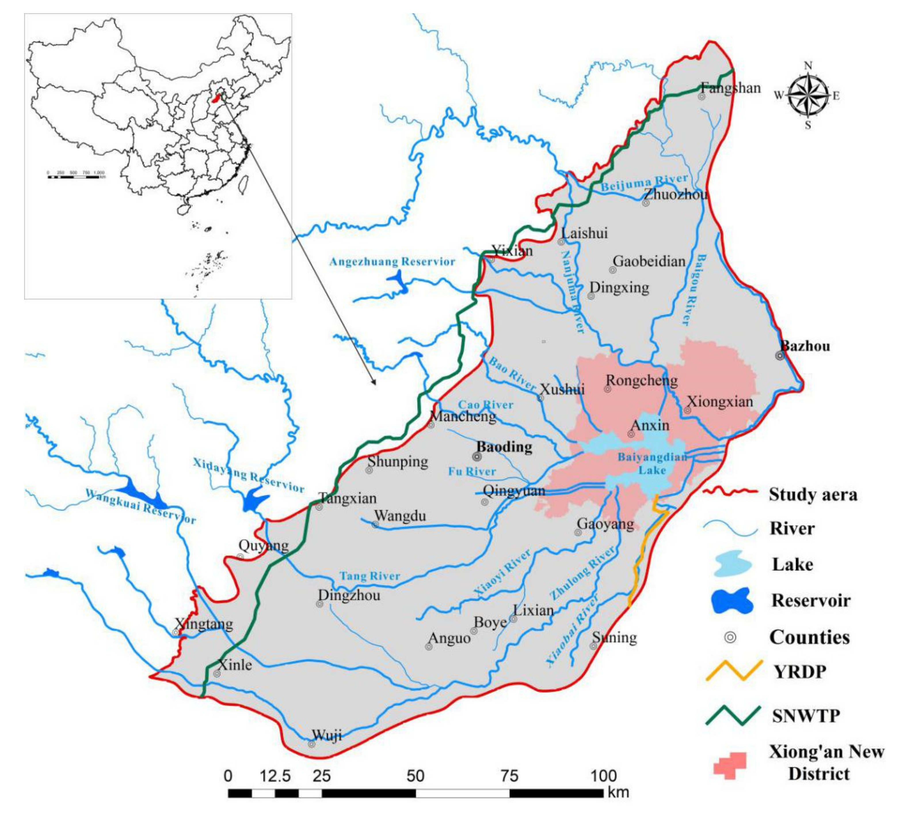
2. Study Area
3. Materials and Methods
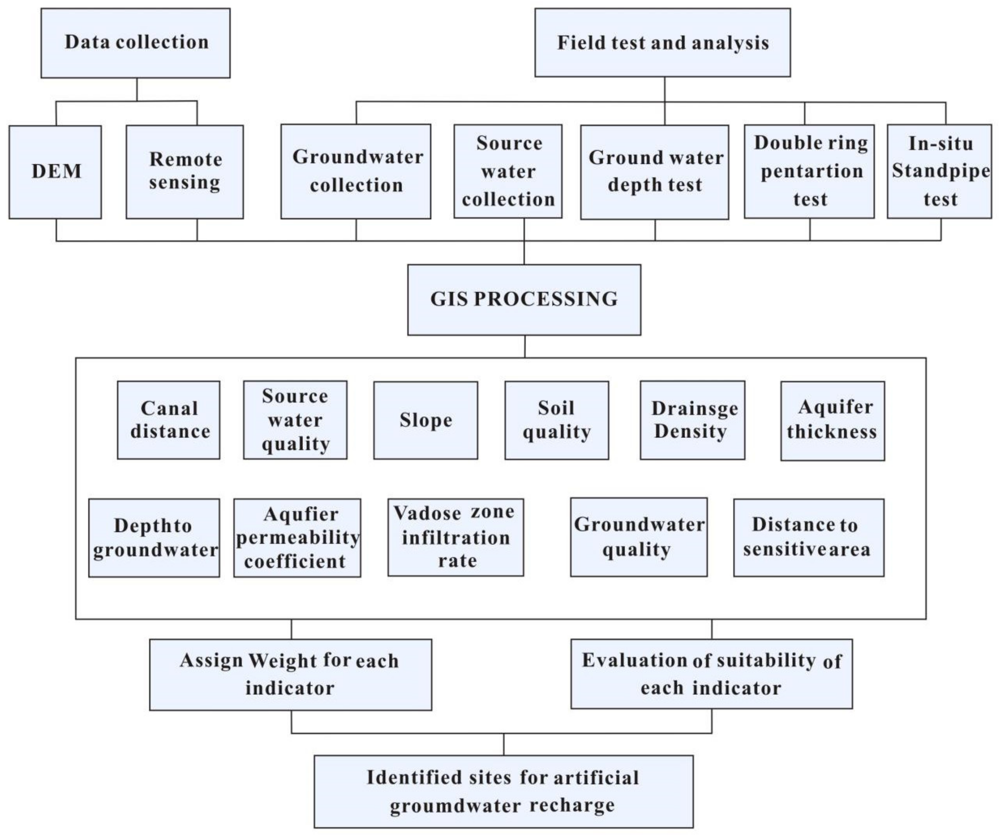
3.1. Data Acquisition
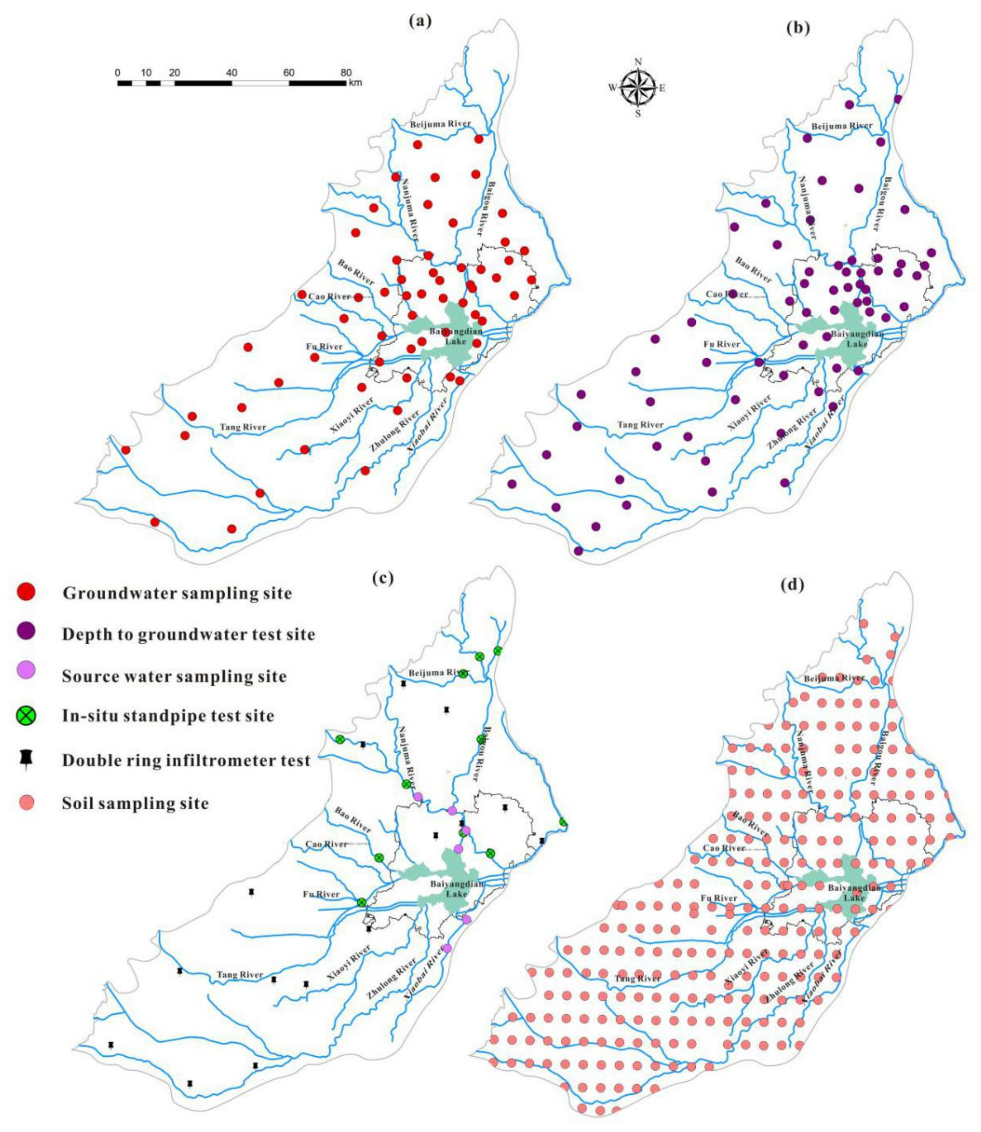
3.2. Sampling and Investigation
3.3. Methodological Framework
3.4. Multi-Criteria Evaluation Method
3.5. Evaluation Indicator System
- The target layer: there is only one element in this layer, which is the preset goal or expected result of complex problems.
- The criterion layer: this is the middle level for achieving the goal and the criteria to be considered, and it can be composed of several levels.
- The indicator layer: this layer includes the specific indicators selected to support the elements of the criterion layer, and to achieve the ultimate goal of the target layer.
4. Results and Discussion
4.1. Water Source Conditions
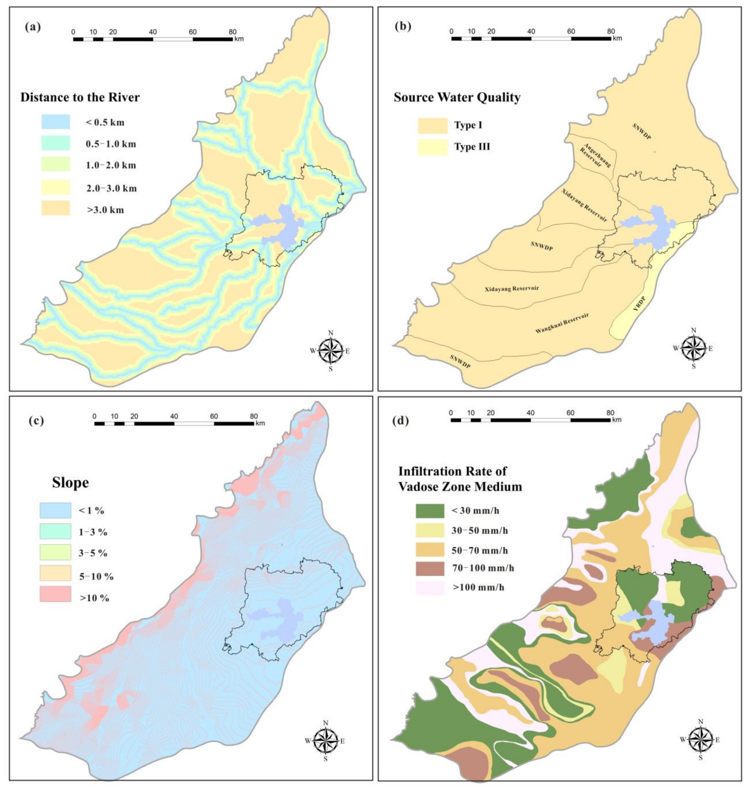
4.1.1. Distance to a Canal
4.1.2. Source Water Quality
4.2. Infiltration Conditions
4.2.1. Slope
4.2.2. Vadose Zone Infiltration Rate
4.2.3. Drainage Density
4.3. Storage Conditions
4.3.1. Depth to Groundwater
4.3.2. Aquifer Hydraulic Conductivity
4.3.3. Aquifer Thickness
4.4. Environmental Conditions
4.4.1. Groundwater Quality
4.4.2. Soil Quality
4.4.3. Distance to Sensitive Areas
4.5. Weight Calculation
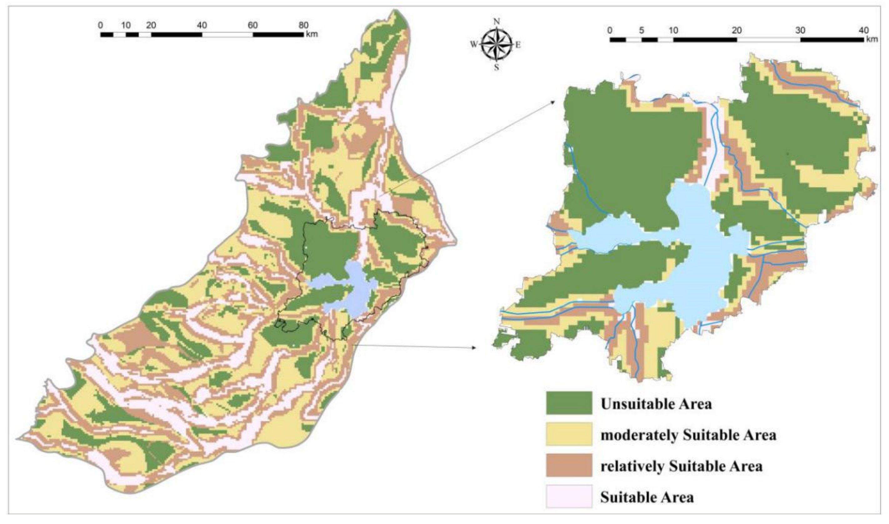
4.6. Identification of Suitable Sites for Artificial Recharge
5. Discussion and Conclusions
Author Contributions
Funding
Data Availability Statement
Conflicts of Interest
References
- Todd, D.K.; Mays, L.W. Groundwater Hydrology, 3rd ed.; John Wiley & Sons: Hoboken, NJ, USA, 2005; Available online: https://www.wiley.com/en-us/GroundwaterþHydrology%2Cþ3rdþEdition-p-9780471059370 (accessed on 1 January 2020).
- Sandoval, J.A.; Tiburan, C.L., Jr. Identification of potential artificial groundwater recharge sites in mount makiling forest reserve, Philippines using GIS and analytical hierarchy process. Appl. Geogr. 2019, 105, 73–85. [Google Scholar] [CrossRef]
- Bouwer, H. Artificial recharge of groundwater: Hydrogeology and engineering. Hydrogeol. J. 2002, 10, 121–142. [Google Scholar] [CrossRef] [Green Version]
- Singh, S.K.; Zeddies, M.; Shankar, U.; Griffiths, G.A. Potential groundwater recharge zones within New Zealand. Geosci. Front. 2019, 10, 1065–1072. [Google Scholar] [CrossRef]
- Asano, T. Artificial Recharge of Groundwater; Butterworth Publishers: Oxford, UK; United Nations Environment Programme: Nairobi, Kenya, 1985. [Google Scholar]
- Oaksford, E. Artificial recharge: Methods, hydraulics, and monitoring. In Artificial Recharge of Groundwater; Asano, T., Ed.; Butterworth Publishers: Oxford, UK, 1985; pp. 69–127. [Google Scholar] [CrossRef]
- United Nation Environment Programme (UNEP). Artificial Recharge of Groundwater. Alternative Technologies for Freshwater Augmentation in Some Countries in Asia. 2011. Available online: http://www.unep.or.jp/ietc/publications/techpublications/techpub-8e/artificial.asp (accessed on 18 October 2017).
- Luo, F. Research on Site Suitability Evaluation of Reclaimed Water Well Irrigation and River Infiltration to Recharge Groundwater. Master’s Thesis, China University of Geosciences, Beijing, China, 2014. (In Chinese). [Google Scholar]
- Freeze, R.A.; Cherry, J.A. Groundwater; Prentice-Hall: Englewood Cliffs, NJ, USA, 1979; p. 604. [Google Scholar]
- Yeh, H.F.; Cheng, Y.S.; Lin, H.I.; Lee, C.H. Mapping groundwater recharge potential zone using a GIS approach in Hualian River, Taiwan. Sustain. Environ. Res. 2016, 26, 33–43. [Google Scholar] [CrossRef] [Green Version]
- Abdalla, F. Mapping of groundwater prospective zones using remote sensing and GIS techniques: A case study from the Central Eastern Desert, Egypt. J. Afr. Earth Sci. 2012, 70, 8–17. [Google Scholar] [CrossRef]
- Hantush, M. Aquifer transmissivity. In Encyclopedia of Water Science; Stewart, A.B., Howell, T., Eds.; CRC Press: New York, NY, USA, 2003; pp. 25–29. Available online: https://cfpub.epa.gov/si/si_public_record_report.cfm?dirEntryId=100243 (accessed on 23 October 2017).
- Gemitzi, A.; Tsihrintzis, V.A.; Christou, O.; Petalas, C. Use of GIS in siting stabilization pond facilities for domestic wastewater treatment. J. Environ. Manag. 2007, 82, 155–166. [Google Scholar] [CrossRef]
- Chenini, I.; Mammou, A.B.; May, M.E. Groundwater recharge zone mapping using GIS-based multi-criteria analysis: A case study in Central Tunisia (Maknassy Basin). Water Resour. Manag. 2010, 24, 921–939. [Google Scholar] [CrossRef]
- Da Costa, A.M.; de Salis, H.H.C.; Viana, J.H.M.; Leal Pacheco, F.A. Groundwater recharge potential for sustainable water use in urban areas of the jequitiba river basin, Brazil. Sustainability 2019, 11, 2955. [Google Scholar] [CrossRef] [Green Version]
- Jang, C.S.; Chen, S.K.; Kuo, Y.M. Applying indicator-based geostatistical approaches to determine potential zones of groundwater recharge based on borehole data. Catena 2013, 101, 178–187. [Google Scholar] [CrossRef]
- Mogaji, K.A.; Omosuyi, G.O.; Adelusi, A.O.; Lim, H.S. Application of GIS-based evidential belief function model to regional groundwater recharge potential zones mapping in hardrock geologic terrain. Environ. Process. 2016, 3, 93–123. [Google Scholar] [CrossRef]
- Rahimi, S.; Roodposhti, M.S.; Abbaspour, R.A. Using combined AHP–genetic algorithm in artificial groundwater recharge site selection of Gareh Bygone Plain, Iran. Environ. Earth Sci. 2014, 72, 1979–1992. [Google Scholar] [CrossRef]
- Wang, P. Application of GIS Multi-Criteria Decision Analysis for Managed Aquifer Suitability Mapping in China. Master’s Thesis, Institutfür Hydrologie und Meteorologie, Nanjing, China, 2017. [Google Scholar]
- Aydi, A.; Abichou, T.; Nasr, I.H.; Louati, M.; Zairi, M. Assessment of land suitability for olive mill wastewater disposal site selection by integrating fuzzy logic, AHP, and WLC in a GIS. Environ. Monit. Assess. 2016, 188, 59. [Google Scholar] [CrossRef] [PubMed]
- Duarte, L.; Teodoro, A.C.; Maia, D.; Barbosa, D. Radio Astronomy Demonstrator: Assessment of the Appropriate Sites through a GIS OpenSource Application. ISPRS Int. J. Geo-Inf. 2016, 5, 209. [Google Scholar] [CrossRef] [Green Version]
- Gdoura, K.; Anane, M.; Jellali, S. Geospatial and AHP-multicriteria analyses to locate and rank suitable sites for groundwater recharge with reclaimed water. Resour. Conserv. Recy. 2015, 104, 19–30. [Google Scholar] [CrossRef]
- Senanayake, I.P.; Dissanayake, D.M.; Mayadunna, B.B.; Weerasekera, W.L. An approach to delineate groundwater recharge potential sites in Ambalantota, Sri Lanka using GIS techniques. Geosci. Front. 2016, 7, 115–124. [Google Scholar] [CrossRef] [Green Version]
- Mahmoud, S.H.; Alazba, A.A. Identification of potential sites for groundwater recharge using a GIS-based decision support system in Jazan region-Saudi Arabia. Water Resour. Manag. 2014, 28, 3319–3340. [Google Scholar] [CrossRef]
- Chen, P. Effects of the entropy weight on TOPSIS. Expert Syst. Appl. 2021, 168, 114186. [Google Scholar] [CrossRef]
- Zhang, Y. Evaluation of Groundwater Artificial Recharge Suitability in plain area of Daqing River Basin based on GIS-EWM. Master’s Thesis, Jilin University, Changchun, China, 2020. (In Chinese). [Google Scholar]
- Thapa, R.; Gupta, S.; Guin, S.; Kaur, H. Assessment of groundwater potential zones using multi-influencing factor (MIF) and GIS: A case study from Birbhum district, West Bengal. Appl. Water Sci. 2017, 7, 4117–4131. [Google Scholar] [CrossRef]
- Kaliraj, S.; Chandrasekar, N.; Magesh, N. Identification of potential groundwater recharge zones in Vaigai upper basin, Tamil Nadu, using GIS-based analytical hierarchical process (AHP) technique. Arab. J. Geosci. 2014, 7, 1385–1401. [Google Scholar] [CrossRef]
- Navane, V.S.; Sahoo, S.N. Identification of groundwater recharge sites in Latur district of Maharashtra in India based on remote sensing, GIS and multi-criteria decision tools. Water Environ. J. 2020. [Google Scholar] [CrossRef]
- Malczewski, J. A GIS-based approach to multiple criteria group decision-making. Int. J. Geogr. Inf. Syst. 1996, 10, 955–971. [Google Scholar] [CrossRef]
- Brema, J.; Arulraj, G. Identification of sites suitable for artificial recharging and groundwater flow modeling in Noyyal river basin, Tamilnadu, India. OIDA Int. J. Sustain. Dev. 2012, 3, 45–58. [Google Scholar]
- Fondriest Environmental, Inc. Conductivity, Salinity and Total Dissolved Solids. Fundamentals of Environmental Measurements. 2014. Available online: http://www.fondriest.com/environmental-measurements/parameters/water-quality/conductivity-salinity-tds/ (accessed on 1 January 2020).
- Standards of Groundwater Quality (GB/T14848-2017). National Standards of People’s Republic of China. 2017. Available online: https://huanbao.bjx.com.cn/news/20171102/858959.shtml. (accessed on 1 January 2020).
- Gogate, N.G.; Rawal, P.M. Identification of potential stormwater recharge zones in dense urban context: A case study from Pune city. Int. J. Environ. Res. 2015, 9, 1259–1268. [Google Scholar] [CrossRef]
- Magesh, N.S.; Chandrasekar, N.; Soundranayagam, J.P. Delineation of groundwater potential zones in Theni district, Tamil Nadu, using remote sensing, GIS and MIF techniques. Geosci. Front. 2012, 3, 189–196. [Google Scholar] [CrossRef] [Green Version]
- Gesim, N.A.; Okazaki, T. Identification of groundwater artificial recharge sites in Herat city, Afghanistan, using Fuzzy logic. Int. J. Eng. Tech. Res. 2018, 8, 40–45. [Google Scholar]
- Ghayoumian, J.; Saravi, M.M.; Feiznia, S.; Nouri, B.; Malekian, A. Application of GIS techniques to determine areas most suitable for artificial groundwater recharge in a coastal aquifer in southern Iran. J. Asian Earth Sci. 2007, 30, 364–374. [Google Scholar] [CrossRef]
- Jasrotia, A.S.; Kumar, R.; Saraf, A.K. Delineation of groundwater recharge sites using integrated remote sensing and GIS in Jammu district, India. Int. J. Remote Sens. 2007, 28, 5019–5036. [Google Scholar] [CrossRef]
- Prabhu, M.V.; Venkateswaran, S. Delineation of artificial recharge zones using geospatial techniques in Sarabanga Sub Basin Cauvery River, Tamil Nadu. Aquat. Procedia 2015, 4, 1265–1274. [Google Scholar] [CrossRef]
- Salar, S.G.; Othman, A.A.; Hasan, S.E. Identification of suitable sites for groundwater recharge in Awaspi watershed using GIS and remote sensing techniques. Environ. Earth Sci. 2018, 77, 701. [Google Scholar] [CrossRef]
- Ghayoumian, J.; Ghermezcheshme, B.; Feiznia, S.; Noroozi, A.A. Integrating GIS and DSS for identification of suitable areas for artificial recharge, case study Meimeh Basin, Isfahan, Iran. Environ. Geol. 2005, 47, 493–500. [Google Scholar] [CrossRef]
- AgriInfo. Factors Affecting Run off. 2003. Available online: http://www.agriinfo.in/?page=topic&superid=8&topicid=60 (accessed on 12 January 2018).
- Das, D. Drainage and lineament analysis towards artificial recharge of groundwater. In Advances in the Research of Aquatic Environment; Lambrakis, N., Stournaras, G., Katsanou, K., Eds.; Springer: Berlin/Heidelberg, Germany, 2011; pp. 37–44. [Google Scholar]
- Sedhuraman, M.; Revathy, S.S.; Babu, S.S. Integration of geology and geomorphology for groundwater assessment using remote sensing and GIS techniques. Int. J. Innov. Res. Sci. Eng. Technol. 2014, 3, 71–85. [Google Scholar]
- Sener, E.; Davraz, A.; Ozcelik, M. An integration of GIS and remote sensing in groundwater investigations: A case study in Burdur, Turkey. Hydrogeol. J. 2005, 13, 826–834. [Google Scholar] [CrossRef]
- Waikar, M.L.; Nilawar, A.P. Identification of groundwater potential zone using remote sensing and GIS technique. Int. J. Innov. Res. Sci. Eng. Technol. 2014, 3, 12163–12174. [Google Scholar]
- Agarwal, R.; Garg, P.K. Remote sensing and GIS based groundwater potential & recharge zones mapping using multi-criteria decision making technique. Water Resour. Manag. 2016, 30, 243–260. [Google Scholar] [CrossRef]
- Chitsazan, M.; Akhtari, Y. A GIS-based DRASTIC model for assessing aquifer vulnerability in Kherran Plain, Khuzestan, Iran. Water Resour. Manag. 2009, 23, 1137–1155. [Google Scholar] [CrossRef]
- Blancada, S. Identifying Potential Artificial Groundwater Recharge Sites in Metro Manila for Stormwater Disposal Using GIS Techniques. Bachelor’s Thesis, University of the Philippines Diliman, Quezon City, Philippines, 2014. [Google Scholar]
- Hammouri, N.; Al-Amoush, H.; Al-Raggad, M.; Harahsheh, S. Groundwater recharge zones mapping using GIS: A case study in Southern part of Jordan Valley, Jordan. Arab. J. Geosci. 2014, 7, 2815–2829. [Google Scholar] [CrossRef]
- Singh, L.K.; Jha, M.K.; Chowdary, V.M. Multi-criteria analysis and GIS modeling for identifying prospective water harvesting and artificial recharge sites for sustainable water supply. J. Clean. Prod. 2017, 142, 1436–1456. [Google Scholar] [CrossRef]
- Singh, A.; Panda, S.N.; Kumar, K.S.; Sharma, C.S. Artificial groundwater recharge zones mapping using remote sensing and GIS: A case study in Indian Punjab. Environ. Manag. 2013, 52, 61–71. [Google Scholar] [CrossRef]
- Krishnamurthy, J.; Mani, A.; Jayaraman, V.; Manivel, M. Groundwater resources development in hard rock terrain-an approach using remote sensing and GIS techniques. Int. J. Appl. Earth Obs. Geoinf. 2000, 2, 204–215. [Google Scholar] [CrossRef]
- Riad, P.H.; Billib, M.H.; Hassan, A.A.; Omar, M.A. Overlay weighted model and fuzzy logic to determine the best locations for artificial recharge of groundwater in a semi-arid area in Egypt. Nile Basin Water Sci. Eng. J. 2011, 4, 24–35. [Google Scholar]
- Soil Environmental Quality Risk Control Standards for Soil Pollution of Agricultural Land (GB15618-2018), National Standards of People’s Republic of China. 2018. Available online: http://www.mee.gov.cn/xxgk2018/xxgk/xxgk01/201807/t20180703_629589.html. (accessed on 1 January 2020).
- Li, H. Establishment and Application Research on Suitability Evaluation System of Reclaimed Water Surface Infiltration Site. Master’s Thesis, China University of Geosciences, Beijing, China, 2013. (In Chinese). [Google Scholar]


| Sampling/Investigation | Numbers | Test Index | |
|---|---|---|---|
| Sampling | Groundwater quality | 60 | Total Hardness(TH), Total Dissolved Solids(TDS), Chemical Oxygen Demand(COD), SO42−, Cl−, Fe, Mn, Cu, Zn, Al, NH4-N, S2−, Na+, NO3-N, NO2-N, F, Cr, As, Cd, Pb, Hg |
| Sampling | Source water quality | 10 | pH, DO, COD, S2−, F−, Cu, Zn, As, Cr, Pb, Cd, Hg, NH4-N, and Total Nitrogen(TN) |
| Sampling | Soil quality | 262 | pH, TN, P, K, Cd, Cr, Cu, Hg, Ni, Pb, Zn, 1,2,3,4,5,6-Hexachlorocyclohexane(BHC),Dichlorodiphenyltrichloroethane(DDT) |
| Test | Vadose Zone Infiltration Rate | 16 | Double-ring infiltrometer test |
| 11 | In-situ standpipe test | ||
| Test | Depth to groundwater | 75 | -- |
| Investigation | Distance to Sensitive Area | 20 | -- |
| Target Layer | Criterion Layer | Indicator Layer |
|---|---|---|
| Suitability of artificial groundwater recharge | Source water conditions | Distance to canal |
| Source water quality | ||
| Recharge infiltration conditions | Slope | |
| Vadose zone infiltration rate | ||
| Drainage Density | ||
| Aquifer storage conditions | Depth to groundwater | |
| Aquifer hydraulic conductivity | ||
| Aquifer thickness | ||
| Environmental conditions | Groundwater quality | |
| Soil quality | ||
| Distance to sensitive area |
| Target Layer | Criterion Layer | Indicator Layer | Indicator Weight | |
|---|---|---|---|---|
| Suitability of artificial groundwater recharge | Source water conditions | Distance to canal | 0.294 | 0.261 |
| Source water quality | 0.033 | |||
| Recharge infiltration conditions | Slope | 0.262 | 0.054 | |
| Vadose zone infiltration rate | 0.195 | |||
| Drainage Density | 0.013 | |||
| Aquifer storage conditions | Depth to groundwater | 0.320 | 0.110 | |
| Aquifer hydraulic conductivity | 0.129 | |||
| Aquifer thickness | 0.081 | |||
| Environmental conditions | Groundwater quality | 0.124 | 0.051 | |
| Soil quality | 0.050 | |||
| Distance to sensitive area | 0.023 | |||
Publisher’s Note: MDPI stays neutral with regard to jurisdictional claims in published maps and institutional affiliations. |
© 2021 by the authors. Licensee MDPI, Basel, Switzerland. This article is an open access article distributed under the terms and conditions of the Creative Commons Attribution (CC BY) license (https://creativecommons.org/licenses/by/4.0/).
Share and Cite
Xu, G.; Su, X.; Zhang, Y.; You, B. Identifying Potential Sites for Artificial Recharge in the Plain Area of the Daqing River Catchment Using GIS-Based Multi-Criteria Analysis. Sustainability 2021, 13, 3978. https://doi.org/10.3390/su13073978
Xu G, Su X, Zhang Y, You B. Identifying Potential Sites for Artificial Recharge in the Plain Area of the Daqing River Catchment Using GIS-Based Multi-Criteria Analysis. Sustainability. 2021; 13(7):3978. https://doi.org/10.3390/su13073978
Chicago/Turabian StyleXu, Guigui, Xiaosi Su, Yiwu Zhang, and Bing You. 2021. "Identifying Potential Sites for Artificial Recharge in the Plain Area of the Daqing River Catchment Using GIS-Based Multi-Criteria Analysis" Sustainability 13, no. 7: 3978. https://doi.org/10.3390/su13073978