1. Introduction: Emerging Research Questions in the Framework of Global Strategies
In the scientific and cultural debate of the discipline of urbanism, the concept of the Digital Twin (DT) applied to cities, sustainable urban policy development, and governance is currently one of the most discussed and cutting-edge topics. In order to contextualise the concept of DTs, the following is a broad definition borrowed from Bolton [
1], which summarises the concept of DTs as ‘...
a dynamic virtual representation of a physical object or system across its lifecycle, using real-time data to enable understanding, learning and reasoning’. This virtual representation, thus defined, has been enabled by digital technological progress and, in particular, by the new data acquisition and processing technologies that, in general, refer to the field of geomatics, information technology, and the world of geo-spatial information (Geographic Information System, GIS).
Within this multi-disciplinary and trans-scalar area of research, the DT for Urban Planning pursues, openly and depending on the case, some directives or warnings on the present and future of cities. Those indications are contained in technical-scientific dossiers (e.g., Intergovernmental Panel on Climate Change, IPCC, 2014 [
2,
3]) or in over-national strategic programmes such as the European New Green Deal [
4], the Agenda for Sustainable Development and its Sustainable Development Goals (SDGs [
5]), or in the New Urban Agenda.
The urbanistic application of this tool, which has been experimented mainly in other disciplines, is motivated by the need to analyse urban dynamics and assess them in advance in order to optimise the efficiency and impact of new projects on the urban landscape. Generally speaking, and this is perhaps the most interesting aspect of the urban declination, it aims to provide a systematic and timely local response to the problems of our time, aggravated by the structural fragility and increasing population density of cities. In this sense, we refer specifically to the impacts of climate change, the loss of naturalness, permeability, and biodiversity in cities, unsustainable patterns of transport, and the impacts of human activities on biophysical and atmospheric components and consequently on people’s wellbeing [
6,
7]. Of course, having a virtual copy of a city is not automatically the solution to such deep-rooted problems, but it is an experimental 3D cyber-space for monitoring, multi-stakeholder cooperation, and action-research towards more adaptive, healthy, and liveable forms of cities. Developing a city-DT means adopting the principles of security, sustainability, and equity that future urban policies should pursue (SDGs, 11), but also becoming aware of the climate-altering impacts due to the
forma urbis and the increasing anthropic pressure on the city–landscape–inhabitant system [
8].
In this regard, Europe has for years been asking administrators and decision-makers to undertake environmentally, socially, and economically sustainable urban planning strategies [
9], capable of:
Empowering urban actors towards common goals and meeting the real needs of communities (people-oriented planning);
Providing administrations with an interactive and proactive ‘working table’ to support decision-making and citizen involvement (digital-platform);
Promoting the creation of integrated, open, and functional technological infrastructures for the development of programmes and the provision of services (data-driven planning).
Within this framework, and considering the various ways in which DT could provide useful services and data to citizens, businesses, and Public Administrations (PAs), the concept of the ‘twin city’ [
10] goes beyond the sectoral approach of the ‘smart city’ [
11] by integrating the two components (virtual/digital and human) within a multi-purpose infrastructure that aims to produce new knowledge from data and vice-versa.
To understand the scope of the Digital Twin theme aimed at the hoped-for ‘twin transition’, it is sufficient to consider that the European Commission (EU) is working on the development of an Earth Digital Twin (‘Destination Earth-DestinE’) [
12] as a cloud-based platform able to receive and share in an open and user-friendly manner various types of data (e.g., Copernicus Project [
13]) and to integrate simulative and predictive models in a single dashboard to support the decision-makers of the Member States with respect to the emerging issues of land–sea–city ecosystems.
In this sense, the renewal of cognitive tools for city government, of which the DT is the current highest expression, appears to be closely linked to the geopolitical context and the need for ‘zero impact’ development aimed at the ecological transition and digital transformation of planning processes.
In this regard, the study intends to provide an overview of the role of the Digital Twin for urban planning by going beyond the mere theoretical-conceptual understanding or the presentation of the architecture and the single technological components that enable its construction, aspects already widely documented in the literature. On the other hand, without entering into individual technical-specialist mono-details but with a trans-disciplinary and multi-thematic approach, the research critically reads some case studies of city-digital twins in progress, highlighting the potential/criticality of the tool, strategic objectives and lines of research investigated, and those that can potentially be pursued.
2. Materials and Methods
2.1. Managing Urban Transformations: Early Considerations from the State of the Art
In scientific production, DT is often, if not always, associated with the concept of smart cities, which, on the one hand, reflects the need for more liveable cities, also thanks to the contribution of digital technology, and on the other, reflects an optimistic view of the future of the technological city. In fact, the term smart conceals a number of critical issues relating to (i) the significant investments/private interests in cities by the ICT (Information and Communication Technology) industry, (ii) the exclusivity of planning through simulative algorithms, obviating the need for an overall urban vision/strategy, and (iii) the ethical and privacy implications of citizens who are ‘controlled’ and whose data are acquired consciously [
14].
In other words, while, on the one hand, private expertise is essential for the development of such complex projects, on the other hand, it entails limitations in the accessibility/sharing/interoperability of data and their use in participatory moments but also in the development of local micro-entrepreneurship. The challenge will drive this significant amount of ICT investments [
15] in order to achieve government’s aims and contemporarily answer citizen’s demands, creating real and useful services for users.
At this point, however, some clarification is necessary: what do Smart Cities and Digital Twin mean? It is difficult to find an unequivocal definition of these concepts in the literature but there is a clear co-creative link: one enables the other and vice-versa [
16,
17,
18]. Indeed, a DT deprived of sensors and synchronous or asynchronous updates between physical reality and its virtual twin would be a mere traditional digital representation (3D-model) of a complex product, process, or system.
The concept of the smart city is inextricably linked to a process of optimising and technologising the urban environment, i.e., making a city ‘smart’ means creating the conditions for improving the quality of life of its inhabitants by enhancing places (work, commerce, leisure, etc.) and facilitating access to services (health, culture, mobility, energy, etc.). This process of digitisation of urban and administrative dynamics is closely interconnected with the issue of DTs. Often there is confusion between Smart City Platforms (SCP) and DTs. The first is a data infrastructure that the PA offers to citizens and the private sector by acquiring data from sensors or the automatic digitisation of services provided, etc.; instead, the SCPs enable the second, when it exists, but goes beyond the provision of data/services for the user, as expressed in the article.
In fact, the new ‘performance’ paradigm of the city is driven by the expansion of infrastructural networks, the continuous advancement in the field of ICT techniques, and geo-informatics technologies related to GIScience or ‘science of where’ [
19].
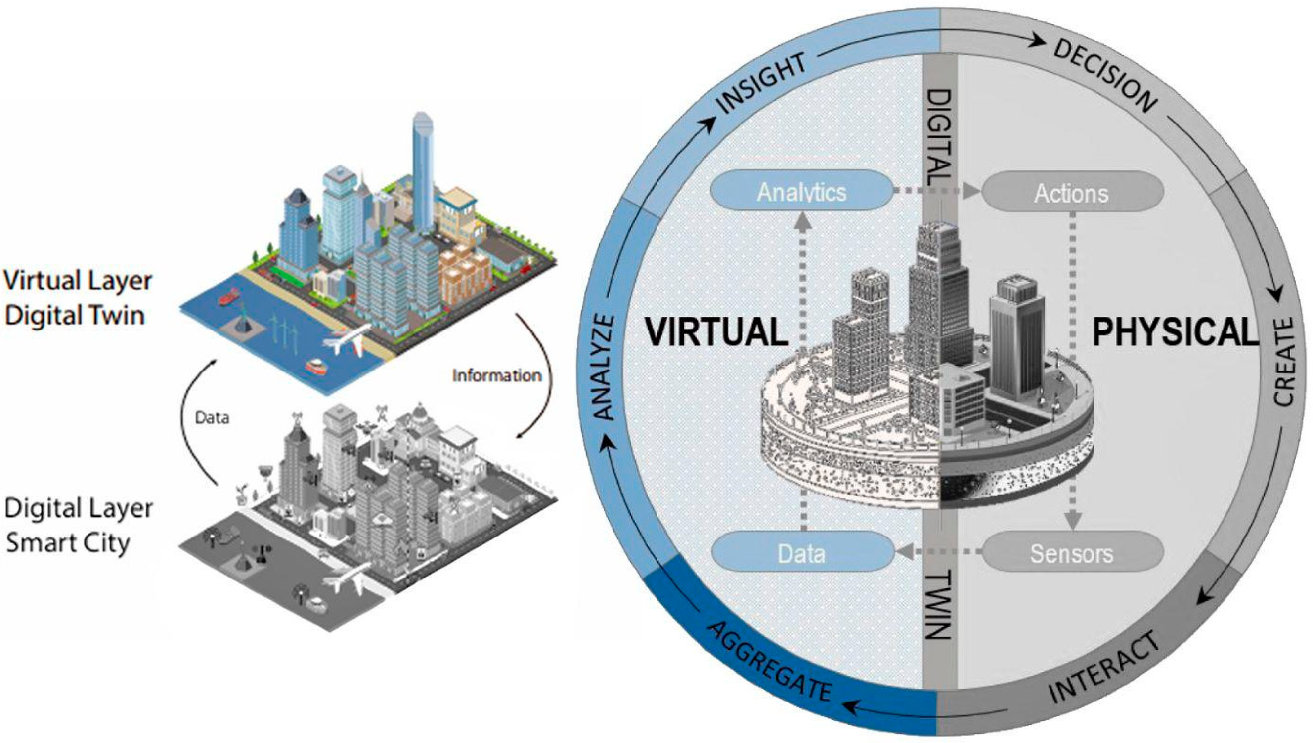
With such a neural network, cities acquire new site-specific and up-to-date information by sensor technologies (Internet of Things—IoT, 5G wireless, etc.). Such data, usually referring to emerging urban planning issues (e.g., interactions between urban morphology, extraordinary weather events and local climate conditions, accessibility, use, and proximity), are collected by sensors and allow the study of vehicular/pedestrian flows (outdoor/indoor), incident weather variables (outdoor), or energy consumption/saving levels (indoor), just to mention some use cases in a DT.
Once processed with qualitative and quantitative methods, techniques, and algorithms (Artificial Intelligence—AI, Cloud Computing, Machine Learning, etc.), the data can be visualised/interrogated through a geo-referenced and navigable platform (e.g., 3D Web-GIS) that would enable administrator–user interaction for information exchange and decision-making [
20,
21,
22] (
Figure 1).
The increasing ability to acquire/store/view and analyse geo-spatial ‘big data’ opens up scenarios of interaction and hyper-connectivity between community, environment, and high-tech devices in a GIS-based environment and/or through Virtual/Augmented Reality (VR/AR) applications. Such immersive technologies are able to visualise and give shape not only to tangible but also to intangible entities (e.g., presence/levels of pollutants) through highly communicative simulations and prefiguration’s. Furthermore, those applications can give a voice and actively involve local communities and other stakeholders in (i) decision-making processes, (ii) awareness-raising on emerging issues, and (iii) dissemination of PAs projects/programmes [
17,
23].
In such a scenario, it is clear that the common factor is data and its flow from physical reality (digital layer/smart cities) to its digital twin (virtual layer/DT), supplying it in space-time and modifying it.
However, what to feed?
2.2. Digital Twin: Definitions and Concept
The notion of the Digital Twin has been present in the literature for about two decades, but there is no standard and univocal definition as it varies, albeit slightly, in relation to the disciplinary scope and purpose for which it was developed. In relation to this conceptual deficit, some transdisciplinary studies [
24,
25,
26,
27,
28,
29] have recently started taxonomic analyses about the historical evolution of the notion of DT.
From these papers and others present in the literature, to which we refer for further study, it is possible to trace a brief excursus of application.
In short, theories and experiments on DT can be found in aerospace prototyping [
30], product and manufacturing [
31,
32], design robotics and automation [
33], biomedical, engineering, and transport applications [
34], or crisis management [
35], to name but a few. Finally, in recent years, it has pervaded the field of urban planning, which we intend to focus on through the review and critical analysis of some case studies.
As suggested by some authors [
36], a city/urban DT is a realistic digital representation of the system of anthropic-infrastructural elements and, less often, of the physical-naturalistic system that presents some invariable characteristics:
Scalability;
Predictability (simulation algorithms);
Integration (IoT sensors, data update, and local knowledge);
Cooperation and accessibility (downloading/uploading data).
The notion of DT has evolved over the last decade due to the increase in data production from various sources (IoT, smartphones, and social media), the ability to digitally reproduce ‘objects’ on a large scale (thanks to Light Detection And Ranging—LIDAR instrumentation, photogrammetric, and Unmanned Aerial Vehicle—UAV applications), the development of software, hardware, and artificial intelligence (AI) algorithms, and the automation of processes.
These innovations of Industry 4.0 [
37] partly influence the different definitions of DT found in the literature, of which we report only a few, considered most significant (
Table 1).
2.3. Case Studies: Selection Method
On the international scene, there are several DT projects underway, but only a very limited number of scientific articles cover and present them, and it is even more complicated to find them in Open-Source (OS) mode. In particular, it is very complicated to find DT projects in non-EU continents because private investment is predominant and no research centres are involved. Therefore, access to detailed information and/or scientific data is limited and some of them are SCPs rather than DTs. In this sense, it is not possible to explore DTs from North America, Asia, and Oceania and few reports are available only on specialised websites (e.g.,
https://www.gim-international.com/,
https://www.smartcitiesworld.net/,
https://sig-digitaltwin-smartgeohub.hub.arcgis.com/). Within this framework, the DT for Amaravati (India) stands out from the rest, as it is the first newly built city previously investigated, and now monitored, through a DT.
To gain an overview of the geographical contexts of international projects, it is useful to make a list of those published in online websites or reported in scientific articles [
39]:
Europe: Cambridge, Dublin, Gothenburg, Helsinki, Herrenberg, London, Munich, Newcastle, Paris, Rennes, Rotterdam, Zurich;
North America: Atlanta, Boston, Boulder, Pasadena, Portland;
Asia and Oceania: Amaravati, Dubai, Jaipur, Singapore, Sidney, Yingtan.
Of these virtual cities, only those highlighted in bold have been selected. This is for two general reasons: (i) they are well represented in one or more scientific articles, and (ii) the material is disseminated in OS mode with a thorough understanding of their general structure and technical specifications.
The research allowed for a critical comparison, potentially updatable as individual projects continue, identifying both similarities and differences, as well as strengths and weaknesses, through certain interpretative categories such as:
Types of DTs;
Scales and portions of the city covered by the project;
Project aims/demands and purposes underlying the investments;
Technologies/software used or developed;
Management of the virtual model;
Simulative experiments and degree of innovativeness.
Using these reading categories, the documentation was systematised and the relevant information on the individual projects was extracted synthetically. In this sense, it is useful to highlight how cities are heterogeneous and different from a geographical and climatic point of view, in terms of the morphology of the urban form, level of governance, etc. The articles themselves do not always present the city or the urban transect in its spatial-functional organisation but rather focus attention on the research activities carried out. For more details about the actors involved or the specificities of the urban contexts, please refer to the literature cited.
3. Results
3.1. Case Studies: Reflections on the Critical Comparative Analysis
The results of the research conducted provide (i) a critical understanding of the significance of the project (next paragraphs) and (ii) a summary table of the characteristics and contents of these virtual replicas of cities realised through transdisciplinary work between public and private institutions, universities, and research institutes. The results, in the form of deductive and comparative critical reflections, are useful for outlining the preliminary trajectories of DT research in the field of urban planning and city studies. In this regard, the case studies, with their diversity, offer a sufficiently broad overview to generalise current lines of research and identify potential future developments. In the following paragraphs, the considerations and evaluations of the projects examined are presented, from which common traits and specificities emerge.
Below is an evaluation table summarising the salient features of the selected case studies (
Table 2).
3.1.1. (Cs)DT: A Digital Twin for Urban Governance—The Case of Cambridge
As pointed out by the authors [
40], the design of the City-scale (Cs) DT for Cambridge (
Figure 2) integrates the development processes of the technological platform with the different political-administrative institutions, the private entities, and some citizen representatives. In this sense, the project seeks to interconnect the objectives of the DT with urban policies and collective demands. This cross-sectoral approach to multi-level governance is a valid example of involving both public and private interests in efficient city planning.
Regional/local public institutions organised workshops, carried out preliminary context studies, and organised interviews with different public/private stakeholders. From the participatory meetings, the stakeholders identified some critical issues: road traffic and pollution, energy infrastructure limited capacity, need to update housing policies and create new jobs. Starting from these addresses, the authors present several two-dimensional ‘what if’ cartographies developed with GIS techniques representing possible scenarios useful to orient the construction of the DT project and new urban strategies. The authors themselves, from the materials they consulted and produced, reconstructed the needs of the PA and the citizens demands that will constitute some of the technical requirements of the future (Cs)DT, which can be summarised as:
Communicating data that influence choices (transparency of data-driven decisions);
Enabling citizens to use the DT (accessibility to data and the possibility of remote feedback to establish a rapid dialogue between the PA and citizens).
The method proposed for the development of this DT enhances the role of the knowledge co-production and of the arduous but necessary dialogue between the territorial actors to link the technological network to the city strategic development objectives. This approach, which is of absolute methodological interest, has slowed down the development of the overall infrastructure of a DT ‘type-model’, which still appears to be in an embryonic phase.
3.1.2. (U)DTs for a Scenario-Based Planning: The Cases of Zurich, Dublin, Helsinki
The articles reviewed for Zurich [
38], Dublin [
22], and Helsinki [
41,
42,
43] show that some European administrations are working on different declinations of Urban-DTs (
Figure 3).
Depending on the contexts and the needs/aspirations of the PAs, the application focus addresses the development of a technological network capable of supporting planning (Zurich, Helsinki) or towards the creation of evolutionary scenarios to which citizens are called to provide qualitative feedback, albeit with unrepresentative numbers (Dublin). The Zurich case study is notable for the underlying planning application, i.e., the DT is part of a broader programme responding to an expected increase of 280,000 inhabitants in the canton by 2040. Among the objectives, in addition to urban densification, the Swiss administration pays particular attention to climate scenarios and risk prevention in order to ensure high standards of liveability in neighbourhoods. In general, while Zurich and Helsinki experiment with simulations concerning the study of shadows, solar radiation and sunshine hours, ventilation analysis, and exposure to noise or pollutants, Dublin focuses on the relationship between planned buildings and the urban skyline and the assessment of risk scenarios related to flooding, safety, and mobility.
The simulations generated in these DTs make use of highly resolved and micro-scalar input data, acquired with the latest technologies and operational methods and produced/delivered in OS mode, as shown in
Figure 3.
Among these projects, Helsinki is certainly a best practice. With this project, the city sets the benchmark for the development of DT for urban planning. In particular, the complexity of the technological platform [
43] earned it the Digital City of the year 2020 award from software development company ‘Bentley Systems’, one of the leading companies in building DTs for PA with ‘Cityzenith’, ‘Cesium’, and others.
In addition, the three DT cases widen the view towards potential spin-offs within real estate construction processes and in the hi-tech industry (ICT start-ups, gaming etc.) of the acquired data, product, and digital by-products developed. At the end, some of the applications tested in these projects also concern the community awareness actions using simplified DTs in gameplay mode (e.g., ‘Minecraft’) or specific PA-to-citizens interfaces for reporting criticalities, expressing appreciation, or proposing project actions.
In conclusion, the three projects link to each other by the operational approach aimed at the preventive assessment of urban transformations and by the transparency and free accessibility of the data. In fact, the partners produced data in CityGML, a semantic city information model based on the OGC (Open Geospatial Consortium) global standards defining an open-source interoperable format for the representation, storage, and exchange of 3D virtual city models.
3.1.3. (P)DT: A Participatory Digital Twin for Consensus-Building in Herrenberg
In the European DT framework, the town of Herrenberg (about 30.000 inhabitants) nearby Stuttgart is experimenting with a Participatory-DT that, although technological, focuses on the involvement of local actors and the potential role of the DT in the dynamics of cooperative planning and co-design [
23,
44]. The use of DTs for co-design and local knowledge learning processes is an emerging and limited theme in the literature. In this sense, this study case acquires an interesting value and is a useful reference to start a bottom-up DT project development.
Certainly, the size of the urban context has facilitated the development of ‘mixed approach’ methods. In fact, the technological component stands on the same level as the social one, according to the democratic-inclusive purpose assigned to this DT (
Figure 4). As in European (U)DTs, the entire development process of the platform is based on the use of OS software (i.e., Simulation of Urban Mobility—SUMO, COllaborative Visualisation and Simulation Environment—COVISE, OpenCOVER, OpenFOAM) and free access to data.
The virtual recreation of the city centre and its surroundings was generated from 3D point clouds, Building Information Modelling (BIM) architectures, and public databases that form the DT’s data infrastructure. Sensors were installed on this neural and technological network to analyse the relationship between traffic and the production/fluidity of pollutants, as the project was driven by the need to safeguard and revitalise the historical-medieval centre affected by pollution. The results of the research were communicated in public meetings and workshops through interactive and experiential modalities of AR that involved the public. In addition, the citizens experimented with the use of a Geo-App (i.e., Reallabor Tracker) for (i) the collection of data to suggest proposals and submit critical issues to the administration (Volunteered Geographic Information—VGI) and (ii) complete questionnaires to assess their appreciation of the tests and the immersive modes of communication.
3.1.4. (CS)DT: Virtual Singapore as A City-State Digital Twin
The Virtual Singapore (VSdt) is a complex and dynamic three-dimensional model of a virtual city. It is a technological platform of queryable 3D data, tools, and simulative/predictive algorithms developed ad hoc to guide the choices of decision-makers. This platform, developed with proprietary software, is intended for the public, private, and research sectors with the aim of creating new businesses linked to the world of digital technologies. A project supported by substantial funds (USD 73 million) and managed by various institutional and government bodies will enable users to access interactive tools and applications, aimed primarily at evaluating and choosing efficient urban development strategies (Decision Support System—DSS) [
45,
46].
The plurality of actors involved, achievable objectives, and issues addressed in this (CS)DT can be found in the literature in various scientific articles. Those selected allow us to consider the VSdt as a real multidisciplinary technological hub able to feed the international state of the art on the subject. In fact, while the digital/virtual development of the built system is well established in European experiences, some research conducted by the project partnership illustrates extremely punctual and state-of-the-art workflows for (i) the analysis of the urban microclimate [
47], (ii) the 3D representation of open-space components with a focus on the geometric-semantic reproduction of vegetation [
48], and (iii) the Level Of Detail (LOD) of the digital model developed with semi-automated geo-AI informatics procedures [
49]. In general, compared to the other DTs examined, this case study also combines technical and technological expertise with the desire to represent the physical world as realistically as possible, ‘spectacularising’ digital navigation and data–model–user interaction (
Figure 5).
4. Discussion: Potential and Limits
From the study conducted, several variations in DT for urban planning emerged, which can be substantially distinguished by scale, purpose, technologies used, and innovation produced in terms of data, techniques, and simulation tools (see
Table 2). The current research defines DT as the most innovative tool in the international urban planning panorama, able (yet potentially) to provide decision-makers with new ways such as:
Simulative/predictive analyses from real measured data (even simultaneously) for modification to specific city systems or places (e.g., accesses and local mobility);
Directing planning choices on the basis of monitoring and historical data series (e.g., maintenance and enhancement of the landscape heritage and urban green areas);
Managing the dynamics of participation and listening to the community involved in a DT project.
None of the case studies reviewed at the moment have developed organic DTs as bridging technology hubs between city government and civil society. In order for these three trends and aspirations to become consolidated reality and not experimenting with single focuses depending on the interest of the individual PA/university, it will take time, greater digital competence within the PAs themselves, but also a process of digital acceptance/alphabetisation of citizens. From the literature, it is clear that data-driven urban planning based on co-design/geodesign methods with citizens, real-time monitoring through sensors, etc. is still in an embryonic research-action phase.
Some of the applications developed in the case studies considered reflect today’s need to rethink cities for flexible, incremental, and adaptive scenarios with respect to the impacts of climate change (Dublin), energy requirements (Cambridge), biodiversity conditions (Singapore), city governance (Cambridge, Singapore, Zurich), land and social demands (Herrenberg, Zurich), environmental conditions (Helsinki), etc. What emerges in general from all six case studies is the need for ‘smart governance’ of cities, in which public administration, the private sector, and inhabitants engage in an open dialogue to share visions for improving local conditions for better liveability.
The scientific production under review shows the progress made on the subject over the last few years, highlighting the innovative and absolutely in-progress state of knowledge on the topic of DT, highlighting both its unquestionable proactive potential for urban and landscape planning and some critical aspects, which can be summarised as follows:
Conflicts of interest between ‘big companies’ and PAs in the area of smart cities/twin cities;
Difficulty in relating the tool to multi-level urban governance instruments and models and to a strategic planning vision;
Complexity of transparent data management, privacy, and democratic processes.
The survey carried out, although not exhaustive, invites a general reflection on the themes and objectives entrusted to this tool. It is clear that this virtual platform must necessarily adapt to not only geographical but also socioeconomic local contexts (a) in order to include the human dimension and the local micro-entrepreneurship ‘
beyond the current technology-driven status quo’ [
40]. In this sense, it would be necessary to understand how small hardware/software developers and the local community can be actively involved in supporting the creation of site-specific virtual models that are not ‘top-down’ with a structure homologated by leading companies.
Furthermore, two main reflections can be made upstream of the open access scientific literature or the consulted sitography. The first (b) concerns the purely urban dimension, i.e., it is not always clear whether the development of the DT is linked to the objectives of territorial government and urban knowledge of places. In this sense, to date, it is premature to argue how this digital tool can accommodate the forecasts of the urban planning instrumentation and drive projects/policies in conformity/disparity by founding choices on simulated scenarios. Second (c), it refers to the rhetoric of the supposed simplification of multi-stakeholder processes by means of new digital technologies. DTs certainly have these prerogatives, but at the moment, considering the experimental nature of the tool and the type of study carried out, it is not possible to evaluate them exhaustively. From this perspective, the sociocultural aspects of the DT as an instrument of choice-making and consensus-building appear to be a further field of research in progress, which, for the success of individual projects, must occupy an equal weight with the technological infrastructure enabling the virtual-city.
In addition to the technical-operational and social components, it is also relevant to point out that open space hardly ever enters into the discussions, which remain mainly in the field of computer-engineering and geomatics, with the exception of VSdt. As illustrated by Gobeawan [
48], a context validated and made realistic by the semantic and biological replication of trees will lead to the development of more accurate spatial analyses and prefigurations dependent on the very individual forms, species-specific generalities, and growth factors that can be associated with each 3D geometry. The vegetation component is not the only characteristic of the open space, but related to the already accurate digital terrain models for which it lays the basis for reproducing and evaluating more faithfully the different and interacting dynamics and fragilities of the urban landscape.
5. Conclusions: Reflections and Future Direction
Research has highlighted the characteristics of DTs as ‘cyber-physical-social eco-systems’ [
50], i.e., as ‘organisms’ with brains and neural functions that reflect, at least in part, and with a certain degree of unavoidable approximation, a physical system, admitting within it immaterial influences. It is clear by comparing the experiences of the DTs that the expert and local components are not yet integrated, but the two-world dialogue is on only a few occasions. This lack thereof is attributable to the complexity of the subject matter, the shortage of staff with such skills in the PAs, and the historical difficulty of local authorities to work in synergy with the social and economic framework of the cities or territories involved.
Some of the DTs under development consider the involvement of residents and their needs as a mandatory part of the project process (Cambridge, Herrenberg). However, as the authors themselves often point out, the number of participants, associations, or categories involved is not yet representative and cannot be generalised. It will be necessary to wait for the developments of the same and other research to understand if technological procedures and DTs can (i) facilitate the democratisation of urban policy choices, (ii) support the governance of the temporal dimension of a city, and (iii) produce from data a new knowledge useful for dimension/qualify planning interventions.
Similarly, the study undertaken showed how geo-technological and ICT progress is able to support, but not replace, traditional urban planning analyses and assessments with innovative survey tools. With respect to these issues, the ongoing and still embryonic characteristics of DTs for urban planning certainly emerge. While, on the one hand, they provide highly accurate 3D reproductions and geo-morphological and architectural models, on the other, they appear to be lacking in the connection between tools and city strategies. In this regard, a prior cognitive and critical-qualitative assessment of contexts, their structural weaknesses, community needs, and strategic planning appears necessary. The DTs should adapt to the real needs of the territories and to the specific future vision of the city at 360° (mobility, waste management, maintenance-implementation of public green areas, new/social housing or urban regeneration projects, etc.). In general, a stronger connection between quantitative and qualitative aspects is highly desirable between the governing body and the resident community. In this perspective, DT will become not only a pioneering tool for data management (‘Data Lake’) but also a proactive platform for the strategic elaboration of new policies-strategies-actions. A simulative, cooperative, and multi-stakeholder ‘smart dashboard’ will enable the assessment of the sustainability of transformations and expand the level of knowledge of the city with the support of new geographic information technologies.
Moreover, almost all DT projects lack the digital configuration of open spaces and vegetation (except for Singapore) as a fundamental and identifying part of the specific urban landscape. These weaknesses open up new avenues of research to explore those gaps and topics. In this sense, the FinEst Centre for Smart Cities (FinEst Centre) of Tallinn University of Technology is currently testing new urban technologies in cooperation with Aalto University and Helsinki Municipality on the topics of urban green digital twins, citizen participation/engagement, sustainable mobility, and urban governance. In particular, the strategic Tallin-Helsinki ‘Dynamic Green Information Model’ project is of high interest and represents a disciplinary advancement [
51].
Broadening the application horizon of the DTs presented, it is useful to point out how this emerging theme is also crossing the purely urban and city limits to involve entire nations, as, for example, in the United Kingdom. In this sense, what is meant is not a single 3D representation of the national territory at the geographical scale, but a chrono program that is aimed at digitising the different cities and individual or systemic components according to the ‘Gemini Principles.’ The result will be an ecosystem of interconnected DTs, especially with regard to the built environment, infrastructure, logistics, and efficient services to support citizens [
52].
In conclusion, the key element of this new paradigm is the spatiotemporal evolution between data and virtual simulation and between semantics and geometry. These properties enable DTs to acquire time series of data through sensors, allowing administrators/users to elaborate ‘real-time’ and ‘data-driven’ scenarios, offering a precise understanding of urban reality. The complex urban dynamics will be increasingly investigated as the Digital Twins evolve. Of particular interest will be advances in research lines on (i) the quality of public space and emerging climate-social-health issues, (ii) the urban agenda timelines and multi-level governance, and (iii) the connections between analogue observation and digital processing for a sustainable and comprehensive urban planning. As emphasised in the paper, the new paradigm of the 3D twin city as a virtual copy of the physical world and its relational dynamics opens up new cognitive horizons for environment-city-inhabitants studies. In this perspective, the digital transformation behind the renewal of the cognitive processes and operational tools of urban planning is also a process of cultural-political evolution in which the traditional tools of the discipline and the digital components of the ‘science of where’ could and should integrate.
Author Contributions
The scientific contents of this research were produced and developed collegially by all the authors within the framework of the “Casa delle Tecnologie Emergenti di Matera” (CTEMT) project. All authors collaborated in the collection, analysis, validation and writing of the article in draft and final version. Specific authors contributions: conceptualization, data curation, methodology, resources, validation, writing-review and editing, G.C. (Giorgio Caprari), G.C. (Giordana Castelli), M.M., M.C. and R.M.; formal analysis, investigation, visualization, G.C. (Giorgio Caprari); project administration, G.C. (Giordana Castelli); supervision, G.C. (Giordana Castelli). All authors have read and agreed to the published version of the manuscript.
Funding
This research is framed within CTEMT Project financed by the Ministry of Economic Development (MISE, Italy) with convention prot.G.0010812/2020-U-, 5 February 2020, signed between the MISE and the Municipality of Matera (Basilicata Region, Italy). In particular, this research is placed within work package 1 (WP1), “Realising the digital urban twin”, implemented and coordinated by the National Research Council (CNR-Italy) with the technical-scientific support of the National Institute of Urbanism (INU-Italy), signed with convention prot_65562_06102021.
Institutional Review Board Statement
Not applicable.
Informed Consent Statement
Not applicable.
Data Availability Statement
Not applicable.
Acknowledgments
This work acknowledges the entire CNR research group involved in CTEMT-WP1 project, in particular to the scientific coordinators and researchers of the Department of Engineering, ICT and Technologies for Energy and Transport (DIITET), Institute for High Performance Computing and Networking (ICAR), Institute of Cognitive Sciences and Technologies (ISTC), Institute of Marine Engineering (INM), Institute of Complex Systems (ISC), Institute of Applied Mathematics and Information Technology (IMATI), Institute of Electronics, Information Engineering and Telecommunications (IEIIT), Institute of Systems Analysis and Informatics “Antonio Ruberti” (IASI), Institute of Applied Physics “Nello Carrara” (IFAC). Specifically, we give great thanks to Emilio Fortunato Campana (DIITET Director), Paolo Ravazzani, Gabriella Tognola, Lucanos Strambini (IEIIT), Valentina Colcelli, Antonella Mirabile (IFAC), Michela Mortara, Michela Spagnuolo (IMATI), Riccardo De Benedictis (ISTC), Mario Ciampi, Giuseppe De Pietro (ICAR), Matteo Diez and Giuseppe Stecca (INM). Additionally, the authors would like to thank INU for its technical and scientific support, particularly its President Michele Talia (University of Camerino, Unicam) and Francesco Scorza (University of Basilicata, Unibas). Thanks are also due to the city and municipality of Matera for supporting the development of the CTEMT project as a direct beneficiary of theoretical and applied research. Finally, thanks again to Emilio Fortunato Campana (DIITET, CNR) for his contribution to the scientific supervision of this article.
Conflicts of Interest
The authors declare no conflict of interest.
References
- Bolton, R.N.; McColl-Kennedy, J.R.; Cheung, L.; Gallan, A.; Orsingher, C.; Witell, L.; Zaki, M. Customer experience challenges: Bringing together digital, physical and social realms. J. Serv. Manag. 2018, 29, 776–808. [Google Scholar] [CrossRef]
- IPCC. Climate Change 2014: Impacts, Adaptation, and Vulnerability. Part A: Global and Sectoral Aspects. Fifth Assessment Report of the Intergovernmental Panel on Climate Change; Cambridge University Press: Cambridge, UK, 2014. [Google Scholar]
- IPCC. Intergovernmental Panel on Climate Change. Available online: https://www.ipcc.ch/report/ar6/wg2/ (accessed on 26 March 2022).
- ec.europa.eu. Available online: https://ec.europa.eu/info/strategy/priorities-2019-2024/european-green-deal/delivering-european-green-deal_en#key-steps (accessed on 9 December 2021).
- unric.org/en. Available online: https://unric.org/en/united-nations-sustainable-development-goals/ (accessed on 22 March 2022).
- EU. Climate Change Impact and Adaptation in Europe; JRC PESETA IV Final Report; JRC Science for Policy Report; Publications Office of the European Union: Luxembourg, 2020; ISBN 978-92-76-18123-1. [Google Scholar] [CrossRef]
- EASAC. The Imperative of Climate Action to Protect Human Health in Europe; EASAC Policy Report 28 June 2019; EASAC European Academies’ Science Advisory Council: Halle, Germany, 2019; ISBN 978-3-8047-4011-2. [Google Scholar]
- Oke, T.R.; Mills, G.; Christen, A.; Voogt, J.A. Urban Climates; Cambridge University Press: Cambridge, UK, 2017; ISBN 978-0-521-84950-0. [Google Scholar]
- United Nations Human Settlements Programme (UN-Habitat). World Cities Report 2020—The Value of Sustainable Urbanization; United Nations Human Settlements Programme: Nairobi, Kenya, 2020; ISBN 978-92-1-132872-1. [Google Scholar]
- Shahat, E.; Hyun, C.; Yeom, C. City Digital Twin Potentials: A Review and Research Agenda. Sustainability 2021, 13, 3386. [Google Scholar] [CrossRef]
- Caragliu, A.; Del Bo, C.; Nijkamp, P. Smart Cities in Europe. J. Urban Technol. 2011, 18, 65–82. [Google Scholar] [CrossRef]
- ec.europa.eu. Available online: https://digital-strategy.ec.europa.eu/en/policies/destination-earth (accessed on 26 March 2022).
- Copernicus. Europe’s Eyes on Earth. Available online: https://www.copernicus.eu/en (accessed on 26 March 2022).
- Cureton, P.; Dunn, N. Digital twins of cities and evasive futures. In Shaping Smart for Better Cities—Rethinking and Shaping Relationships between Urban Space and Digital Technologies; Aurigi, A., Odendaal, N., Eds.; Academic Press: Cambridge, MA, USA, 2021; ISBN 978-O-12818636-7. [Google Scholar]
- marketsandmarkets.com. Available online: https://www.marketsandmarkets.com/Market-Reports/digital-twin-market-225269522.html (accessed on 26 March 2022).
- Deren, L.; Wenbo, Y.; Zhenfeng, S. Smart city based on digital twins. Comput. Urban Sci. 2021, 1, 4. [Google Scholar] [CrossRef]
- Hämäläinen, M. Smart city development with digital twin technology. In Proceedings of the 33rd Bled eConference—Enabling Technology for a Sustainable Society, Maribor, Slovenija, 28–29 June 2020; ISBN 978-961-286-362-3. [Google Scholar] [CrossRef]
- Mohammadi, N.; Taylor, J.E. Smart city digital twins. In Proceedings of the 2017 IEEE Symposium Series on Computational Intelligence (SSCI), Honolulu, HI, USA, 27 November–1 December 2017. [Google Scholar]
- Wilson, E.O. GIS for Science. In Maps for Saving the Planet; Wright, D.J., Harder, C., Eds.; Esri Press: Redlands, CA, USA, 2021; Volume 3, ISBN 978-1-58948-671-3. [Google Scholar]
- Deng, T.H.; Zhang, K.R.; Shen, Z.J.M. A systematic review of a digital twin city: A new pattern of urban governance toward smart cities. J. Manag. Sci. Eng. 2021, 6, 125–134. [Google Scholar] [CrossRef]
- Shirowzhan, S.; Tan, W.; Sepasgozar, S.M.E. Digital Twin and CyberGIS for Improving Connectivity and Measuring the Impact of Infrastructure Construction Planning in Smart Cities. ISPRS Int. J. Geo-Inf. 2020, 9, 240. [Google Scholar] [CrossRef]
- White, G.; Zink, A.; Codecá, L.; Clarke, S. A digital twin smart city for citizen feedback. Cities 2021, 110, 103064. [Google Scholar] [CrossRef]
- Dembski, F.; Wössner, U.; Yamu, C. Digital Twin, Virtual Reality and Space Syntax: Civic Engagement and Decision Support for Smart, Sustainable Cities. In Proceedings of the 12th International Space Syntax Symposium, Beijing, China, 8–13 July 2019. [Google Scholar]
- Semeraro, C.; Lezoche, M.; Panetto, H.; Dassisti, M. Digital twin paradigm: A systematic literature review. Comput. Ind. 2021, 130, 103469. [Google Scholar] [CrossRef]
- Ketzler, B.; Naserentin, V.; Latino, F.; Zangelidis, C.; Thuvander, L.; Logg, A. Digital Twins for Cities: A State of the Art Review. Built Environ. 2020, 46, 547–573. [Google Scholar] [CrossRef]
- Nativi, S.; Delipetrev, B.; Craglia, M. Destination Earth: Survey on “Digital Twins” Technologies and Activities in the Green Deal Area; Publications Office of the European Union: Luxembourg, 2020; ISBN 978-92-76-25160-6. [Google Scholar] [CrossRef]
- Trauer, J.; Schweigert-Recksiek, S.; Engel, C.; Spreitzer, K.; Zimmermann, M. What Is a Digital Twin?––Definitions and Insights from an Industrial Case Study in Technical Product Development. In Proceedings of the Design Society: Design Conference; Cambridge University Press: Cambridge, UK, 2020; Volume 1, pp. 757–766. [Google Scholar] [CrossRef]
- van der Valk, H.; Haße, H.; Möller, F.; Arbter, M.; Henning, J.; Boris, O. A Taxonomy of Digital Twins. In Proceedings of the 26th Americas Conference on Information Systems—AMCIS, Salt Lake City, UT, USA, 15–17 August 2020. [Google Scholar]
- Barricelli, B.R.; Casiraghi, E.; Fogli, D. A Survey on Digital Twin: Definitions, Characteristics, Applications, and Design Implications. IEEE Access 2019, 7, 167653–167671. [Google Scholar] [CrossRef]
- Glaessgen, E.; Starge, L.D. The Digital Twin Paradigm for Future NASA and US Air Force Vehicles. In Proceedings of the 53th American Institute of Aeronautics and Astronautics Structures—AIAA, Structural Dynamics and Materials Conference, Honolulu, HI, USA, 23–26 April 2012. [Google Scholar]
- Chen, Y. Integrated and Intelligent Manufacturing: Perspectives and Enablers. Engineering 2017, 3, 588–595. [Google Scholar] [CrossRef]
- Grieves, M.; Vickers, J. Digital Twin: Mitigating Unpredictable, Undesirable Emergent Behavior in Complex Systems. In Transdisciplinary Perspectives on Complex Systems; Springer: Cham, Switzerland, 2017; pp. 85–113. [Google Scholar]
- Huang, Z.; Shen, Y.; Li, J.; Fey, M.; Brecher, C. A Survey on AI-Driven Digital Twins in Industry 4.0: Smart Manufacturing and Advanced Robotics. Sensors 2021, 21, 6340. [Google Scholar] [CrossRef] [PubMed]
- Vrabič, R.; Erkoyuncu, J.A.; Butala, P.; Roy, R. Digital twins: Understanding the added value of integrated models for through-life engineering services. Procedia Manuf. 2018, 16, 139–146. [Google Scholar] [CrossRef]
- Brucherseifer, E.; Winter, H.; Mentges, A.; Mühlhäuser, M.; Hellmann, M. Digital Twin conceptual framework for improving critical infrastructure resilience. Automatisierungstechnik 2021, 69, 1062–1080. [Google Scholar] [CrossRef]
- Castelli, G.; Tognola, G.; Campana, E.F.; Cesta, A.; Diez, M.; Padula, M.; Ravazzani, P.; Rinaldi, G.; Savazzi, S.; Spagnuolo, M.; et al. Urban Intelligence: A Modular, Fully Integrated, and Evolving Model for Cities Digital Twinning. In Proceedings of the 2019 IEEE 16th International Conference on Smart Cities: Improving Quality of Life Using ICT & IoT and AI (HONET-ICT), Charlotte, NC, USA, 6–9 October 2019; pp. 33–37. [Google Scholar]
- Fuller, A.; Fan, Z.; Day, C.; Barlow, C. Digital Twin: Enabling Technologies, Challenges and Open Research. IEEE Access 2020, 8, 108952–108971. [Google Scholar] [CrossRef]
- Schrotter, G.; Hürzeler, C. The Digital Twin of the City of Zurich for Urban Planning. PFG J. Photogramm. Remote Sens. Geoinf. Sci. 2020, 88, 99–112. [Google Scholar] [CrossRef]
- Mukhacheva, A.V.; Ugryumova, M.N.; Morozova, I.S.; Mukhachyev, M.Y. Digital Twins of the Urban Ecosystem to Ensure the Quality of Life of the Population. In Proceedings of the International Scientific and Practical Conference Strategy of Development of Regional Ecosystems “Education-Science-Industry” (ISPCR 2021), Veliky Novgorod, Russia, 7–8 December 2021; Atlantis Press: Paris, France, 2022; pp. 331–338. [Google Scholar] [CrossRef]
- Nochta, T.; Wan, L.; Schooling, J.M.; Parlikad, A.K. A Socio-Technical Perspective on Urban Analytics: The Case of City-Scale Digital Twins. J. Urban Technol. 2020, 28, 263–287. [Google Scholar] [CrossRef]
- Hämäläinen, M. Urban development with dynamic digital twins in Helsinki city. IET Smart Cities 2021, 3, 201–210. [Google Scholar] [CrossRef]
- Ruohomaki, T.; Airaksinen, E.; Huuska, P.; Kesaniemi, O.; Martikka, M.; Suomisto, J. Smart City Platform Enabling Digital Twin. In Proceedings of the 2018 International Conference on Intelligent Systems (IS), Funchal, Portugal, 25–27 September 2018; pp. 155–161. [Google Scholar]
- The Kalasatama Digital Twins Project. Available online: https://www.hel.fi/static/liitteet-2019/Kaupunginkanslia/Helsinki3D_Kalasatama_Digital_Twins.pdf (accessed on 30 March 2022).
- Dembski, F.; Wössner, U.; Letzgus, M.; Ruddat, M.; Yamu, C. Urban Digital Twins for Smart Cities and Citizens: The Case Study of Herrenberg, Germany. Sustainability 2020, 12, 2307. [Google Scholar] [CrossRef]
- Nation Research Foundation—Prime Minister’s Office Singapore. Available online: https://www.nrf.gov.sg/programmes/virtual-singapore/video-gallery (accessed on 27 March 2022).
- gwprime.geospatialworld.net. Available online: https://www.gwprime.geospatialworld.net/case-study/virtual-singapore-building-a-3d-empowered-smart-nation/ (accessed on 27 March 2022).
- Ignatius, M.; Wong, N.H.; Martin, M.; Chen, S. Virtual Singapore integration with energy simulation and canopy modelling for climate assessment. In Proceedings of the IOP Conference Series: Earth and Environmental Science, Tokyo, Japan, 29 August 2019; pp. 12–18. [Google Scholar] [CrossRef]
- Gobeawan, L.; Lin, E.S.; Tandon, A.; Yee, A.T.K.; Khoo, V.H.S.; Teo, S.N.; Yi, S.; Lim, C.W.; Wong, S.T.; Wise, D.J.; et al. Modeling trees for virtual singapore: From data acquisition to citygml models. ISPRS Int. Arch. Photogramm. Remote Sens. Spat. Inf. Sci. 2018, 42, 55–62. [Google Scholar] [CrossRef]
- Gruen, A.; Schrotter, G.; Schubiger, S.; Qin, R.; Xiong, B.; Xiao, C.; Li, J.; Ling, X.; Yao, S. An Operable System for LoD3 Model Generation Using Multi-Source Data and User-Friendly Interactive Editing; Singapore ETH Centre—Future Cities Laboratory: Singapore, 2020. [Google Scholar] [CrossRef]
- Tomko, M.; Winter, S. Beyond digital twins—A commentary. Environ. Plan. B Urban Anal. City Sci. 2018, 46, 395–399. [Google Scholar] [CrossRef]
- FinEst Centre for Smart Cities. Available online: https://taltech.ee/en/finest-centre-for-smart-cities#p53656 (accessed on 30 March 2022).
- University of Cambridge—Centre for Digital Built Britain. Available online: https://www.cdbb.cam.ac.uk/what-we-do/national-digital-twin-programme (accessed on 30 March 2022).
| Publisher’s Note: MDPI stays neutral with regard to jurisdictional claims in published maps and institutional affiliations. |
© 2022 by the authors. Licensee MDPI, Basel, Switzerland. This article is an open access article distributed under the terms and conditions of the Creative Commons Attribution (CC BY) license (https://creativecommons.org/licenses/by/4.0/).


 ,
, 


