Article

Daily Mobility in Urban Peripheries: The Role of Clandestine Taxis in Dakar, Senegal †

1
LAET, ENTPE, Université de Lyon, 69120 Vaulx-en-Velin, France
2
Institut de Gouvernance Territoriale et du Développement Local (UCAD), Dakar 10700, Senegal
3
LGH, Département de Géographie, Université Cheikh Anta DIOP de Dakar, Dakar 10700, Senegal
*
Author to whom correspondence should be addressed.
Sustainable Mobilities, Spatial Planning and Urban Livability.
Sustainability 2022, 14(11), 6769; https://doi.org/10.3390/su14116769
Submission received: 29 April 2022 / Revised: 23 May 2022 / Accepted: 26 May 2022 / Published: 1 June 2022
(This article belongs to the Special Issue Sustainable Mobilities, Spatial Planning and Urban Livability)

Abstract

:
Background: This study addresses the mobility practices of the inhabitants of the peripheries of Dakar and the transport services they use to meet their mobility needs, in particular the unlicensed shared taxis (“Clandos”). In the peripheries, which suffer from a lack of jobs and amenities, mobility is essential to meet household needs and for social integration. Current transport policies focus on formalizing supply and organizing the system around high-capacity transport facilities, such as the Regional Express Railway (TER) or Bus Rapid Transit (BRT), but they have difficulty in dealing with the mobility problems facing the outskirts of the city. Methods: The study is based on secondary analysis of the 2015 Household Travel Survey and on a survey on the activity of Clandos conducted in 2021 in Dakar. Results: The analysis highlights the daily mobility practices of the inhabitants of the peripheral areas. These residents, who are on average poorer than the others, travel mainly on foot. Their access to public transport remains limited and, when they use it, a significant proportion of their trips are made by Clando. Clandos have a dual function. On one hand, they are used for long trips to the center, in competition with buses, but more often they operate as a complement to buses. On the other hand, they are mostly used for local mobility within the peripheries. Conclusions: Although relatively expensive, Clando services are valuable for the inhabitants of the peripheries and their daily mobility. They should be better integrated into transport and planning strategies for the peripheral areas.

1. Introduction

Africa’s major cities are growing at a rapid pace and are characterized by a significant increase in unplanned urban expansion [1]. The severe lack of jobs and amenities in peripheral neighborhoods, as well as their distance from employment centers, add to the vulnerability of their residents and worsen their quality of life. Meeting essential needs (employment, social interaction, health care, education, and food) is dependent on daily mobility and the conditions under which it is performed. In a context where incomes are low and public services and facilities are scarce, travel becomes not only more difficult but also even more essential.
Public transport systems play a fundamental role in providing access to the city, and many cities are attempting to organize them better. To meet growing travel demand, BRT (Bus Rapid Transit), metro and suburban railway lines are being constructed or planned. However, informal transport continues to account for a significant proportion of motorized trips. Defined as “a flexible mode of passenger transportation that does not follow fixed schedules or service spans, and is provided by numerous small private businesses without contractual obligation to a regulatory authority” [2] (p. 1), informal transport takes a wide variety of forms in different cities [3,4,5].
Among them, shared taxis are present in many large cities of sub-Saharan Africa [3]. They are a main component of daily mobility, especially in the peripheries, where other individual and collective motorized modes are less present and even absent. Shared taxis are mainly informal [4,5]. The ways they function and the needs they fulfill remain largely unknown. Better understanding of the unlicensed shared taxi model requires well documented empirical works to construct a set of “good case studies” [6]. The paper aims to contribute to the set, through a precise characterization of this mode and its role in mobility in the Dakar metropolitan region.
The transport system of the capital of Senegal is multifarious. First, it includes institutional transport provision such as the buses operated by the Dakar Dem Dikk (DDD) state-owned company, the AFTU buses and the personal yellow and black taxis. The AFTU buses are the result of a program to modernize the informal sector and replace the vehicles [7]. These services coexist with more informal provision: Cars Rapides minibuses, Ndiaga Ndiaye buses, and unauthorized collective taxis (locally called “Clandos”, for clandestine). In particular, the Clandos—unmarked vehicles carrying between four and six passengers—operate without a license and are not recognized by the authorities [8].
Dakar can be seen as an epitome of the African metropolises that aim to modernize their public transport operations, but where paratransit still largely contributes to fulfill daily mobility needs, especially in the peripheries, in a context of marked urban sprawl [9].
The lack of data is a main issue in Africa [10], making it difficult to gain knowledge of the role of the different modes of transport, especially those that operate informally. The situation is different in Dakar. A household travel survey (HTS) was carried out in 2015. It allows better knowledge and understanding of travel behavior. In addition, we realized an ad hoc survey that focused on the location and operation of shared taxi stands in November 2021 and March 2022. Combining the two sets of original data allows us to better characterize and understand the role of clandestine shared taxis in the urban mobility system.
After a literature review of the daily mobility issues associated with urban sprawl and the role of informal transport (Section 2), we will present the urban and transport context in Dakar, and the survey data we analyzed (Section 3). Section 4 sets out some findings on the mobility of people living in the city’s outskirts and their use of Clandos, in relation to the organization and spatial presence of this informal mode of transport, before providing readers with a discussion and conclusion (Section 5).

2. Literature Review

The cities of the Global South, and in particular the cities of sub-Saharan Africa, are experiencing significant growth rates. They are reflected in substantial spatial expansion and living conditions that are frequently precarious in peripheral areas [1,11]. The urban peripheries are formed by the arrival of migrants, often from rural areas, but also of urban populations who leave central areas to obtain dwellings of their own.
These increasingly distant peripheral areas are characterized by a lack of infrastructure and urban amenities, to the point of creating “urbanization without a city, without services, urbanity or centrality” [12] (p. 136). Often poor, the people who live in the outskirts do not have the means to move to areas with better amenities, jobs, and transportation networks. They devote a significant proportion of their income and time to mobility. The combination of poor transport services and social problems creates transport poverty, which exacerbates difficulties in accessing goods, services, and social networks, and increases the risk of social exclusion [13]. These difficulties conspire to limit the ability of the peripheral residents to access the city and keep them poor [9].
Access to mobility is a major issue for people living in the outskirts of sub-Saharan African cities. Their main mode of transport is walking, although the urban environment is rarely suitable for walking, and indeed is often even hostile to it. Residents can attempt to use their own resources to improve urban spaces to facilitate walking and make their neighborhoods more livable [14]. However, the limited distances that can be covered by walking mean that it does not provide genuine access to the city, so the use of a motorized mode may be inevitable. Faced with a very limited choice of transport modes [9], residents of the outskirts are forced to combine use of motorized modes and walking in different ways depending on the nature of the activity prompting the trip, and its frequency. When they choose the fastest (and most expensive) mode, the working population does so mainly to access to the city center, or for work-related trips [15,16,17]. But, more often than not, those living in the outskirts will opt for walking for trips that are not time sensitive, such as shopping, recreation, local sociability, or work when it is not too far from home. The more comfortable modes—taxis or shared taxis—are reserved for certain purposes, often when there is no alternative, such as to access health care or carry goods [17].
Within this context of constrained mobility, informal transport plays a key role for gaining access to opportunities [18]. It fills a gap in transport supply in areas where institutional public transport services are nonexistent or inadequate [4,19,20]. Informal transport services, in the form of shared taxis, minibuses, and the rapidly proliferating motorcycle taxis [21], crisscross the various neighborhoods and provide access to central areas or stops served by higher-capacity modes. Informal transport may compete with or complement the public supply.
It can be considered in competition with institutional public transport when it operates on the same routes. Informal transport also complements public supply in two configurations that are not mutually exclusive: (i) when its routes are specific or are poorly served by other forms of public transport (within the peripheries and on the margins); and (ii) when its main stops are located near terminal bus stops and it is used as a feeder mode.
The attitude of the public authorities fluctuates between the desire to harness informal transport for it to carry passengers onto the bus networks or BRT lines, and the wish to thwart its operation and eliminate it. This lack of recognition is not conducive to the development of accessibility in some neighborhoods [21,22]. It may undermine the ability of the large numbers of low-skilled workers who produce these services to earn their living [18,23].
All African cities have to deal with informal transport, which dominates the market share of public transport [19]. Various studies have focused on the operation and performance of informal transport and on how it might be improved, combined with, or integrated into larger-capacity modes [24,25,26,27,28,29,30]. In contrast, due to a lack of survey data, there is little research on the demand for public transport [31] and particularly on the demand for informal transport [32]. This point illustrates a more general lack of data on travel behavior in Africa [9]. Given rapid urban sprawl, gaining an understanding of the role of informal transport in serving urban peripheries is an all-important issue. With a better understanding, we can avoid the error of romanticizing the informal sector [33]. Such knowledge of the role played by the Clandos in meeting the mobility needs of the inhabitants of outlying districts, but also of the mode’s limitations and negative aspects, is a precondition for any process of integration.

3. Context and Methods

3.1. Dakar and Its Transport System

The Dakar metropolitan region is located in the west of Senegal on the Cape Verde Peninsula. It measures 45 km from east to west and is divided into four departments: the central department of Dakar, the inner suburban department of Guédiawaye, and the outer suburban departments of Pikine and Rufisque. It had a population of 3.1 million in the 2013 census, and 3.9 million in 2021 according to the most recent estimates [34]. More than 60 percent of the population lives in the outlying departments of Pikine (37.3 percent), Rufisque (15.6 percent), and Guédiawaye (10.5 percent) [35]. The populations of Pikine and Rufisque are somewhat younger than those of Dakar and Guédiawaye, with more schoolchildren and fewer working people. They are also poorer (see Section 4.1).
After an influx of many rural migrants during the 1970s and 1980s, the outskirts of Dakar are now experiencing significant centrifugal movement of residents from the city. The unidirectional peripheral residential expansion of the Dakar region accentuates the imbalance between its functional and geographical centralities [36,37]. The increasing distance of residential areas from the locations of economic activity, administrations, and public facilities generates travel flows that exceed the capacity of the existing transport network.
Since the early 2000s, the Senegalese government has been pursuing a proactive policy of creating business and service centers modeled on international standards. These centers are located on the outskirts of the city. They have been created independently from their surrounding neighborhoods and do not foster their development. To connect the city center at the end of the peninsula and these employment and service centers to each other and to the residential areas, the state is investing in major transport infrastructures: opening the toll highway and the Regional Express Railway (TER) line and the construction of a BRT.
Urban land-use policy suffers from a lack of regulation both for the overall planning of the metropolitan region and for the internal planning of the new expansion areas [38] where the construction of housing precedes basic urban services, in particular roads and public transport networks. Likewise, urban transport planning is very quickly outpaced by the urbanization dynamics of the peripheral zones.
The various forms of public transport are the only motorized transport available to the majority of Africa’s urban residents. On a given weekday, 38 percent of Dakar’s residents use public transport. Formal and informal transport operators focus on different segments of demand with reference to the main roads, the catchment areas, and the advancing edge of the metropolis [39]. In particular, the Clandos have flourished in parallel with the expansion of the peripheral areas since 2000 [40]. The number of Clandos in circulation was estimated to be over more than 3000 in the early 2010s [41]. Currently, there is no official figure [42].
The public bus company Dakar Dem Dikk has created routes that connect different peripheral zones to meet the needs of users in the outer districts. These peripheral areas are also served by AFTU bus routes. However, these routes are not sufficient. Informal transport appears to be better able to respond to the rapid changes that are taking place in an under-served urban fabric.
However, in the eyes of the public authorities, Clandos compete unfairly with buses, occupy public space unnecessarily, and heighten congestion and pollution. They are currently trying to replace them by authorized shared-taxi firms, which are being trialed in Pikine and Rufisque [8]. This trial remains experimental and limited in number. Licenses are still pending [8,42].

3.2. Data

This paper is based on analyses of two sets of empirical data carried out in the Dakar region:
(1)
Secondary analyses of the 2015 HTS. The HTS (EMTASUD 2015) was carried out in the Dakar region by the Sitrass–Curem consortium [31], in which two of the authors participated. The HTS was used to analyze daily mobility behavior and Clando use.
(2)
As the geographical accuracy of the locations in the HTS was not sufficient to locate Clando stands, we launched a survey on the location and organization of Clando stands.
The HTS was conducted as follows. After spatial stratification of the region, a selection of surveyed census districts was made within each geographic stratum. A list of households was then randomly selected in each district. After weighting, the sample (13,415 individuals aged 11 years and older from 3176 households) was representative of the population [43]. Individuals in the household reported the characteristics of all their trips the day before the survey day, including any short trips made entirely on foot.
The Clando survey was centered on their stands (Figure 1). The stands are stations that are the starting points for the Clandos and the places where their activity is organized [44]. They assign Clando drivers to fixed routes, picking up passengers on the basis of taking turns, grouping drivers together in a variety of ways (group, association, economic interest grouping, etc.), developing social ties, etc.
The survey was conducted with students from Cheikh Anta Diop University in Dakar in November 2021 and March 2022. We designed the survey and piloted data collection. The Dakar region was divided into 36 zones. The trained surveyors covered the public space, zone by zone. A pre-test was made in one zone to validate the methodology. The surveyors georeferenced the Clando stands with the Geotracker app and filled an observation sheet. Then, they administered a questionnaire to the managers of the stands, regarding the routes served, the public transport stops in the immediate vicinity, and the organization of the stand (date of creation, number of drivers, type of organization, etc.) [45].

4. Results

4.1. Travel among the Residents of the Outskirts

The differences in mobility and mode use should be seen in relation to the social make-up of the different departments of the Dakar region.

4.1.1. Poorer Households in the Outskirts

The working population of the departments of Pikine and Rufisque are more likely to have non-salaried jobs (this applies to two-thirds of them) than that of Guédiawaye and Dakar (three-fifths and one-half, respectively). More of them work in the informal economy. Their median income is lower (CFAF 75,000 (CFAF 1000 = EUR 1.5) per month) than in Guédiawaye (CFAF 91,000) and Dakar (CFAF 108,000). A majority of households in Pikine and Rufisque are in the low (Q2) or very low (Q1) income groups (Figure 2).

4.1.2. The Dominance of Walking

The modal split highlights the very high proportion of trips that were made entirely on foot in the Dakar region in 2015 (70%), with 24% made by public transport (PT), 4% by private car, and 1% by motorized two-wheeler. For public transport, the AFTU buses accounted for the largest percentage (36%), followed by the Cars Rapides (20%). Clandos accounted for 12% of trips, yellow and black taxis for 10.5%, DDD buses for 6.5%, and Ndiaga Ndiaye buses for 4%. Finally, the remaining 11% consisted of intermodal trips, involving two or more public transport modes. The residents of Rufisque and Pikine make greater use of walking. Walking accounts for up to, respectively, 79% and 74% of their trips, compared to 63% in Dakar and 67% in Guédiawaye. On an average weekday, nonmotorized modes are the most frequently used in Dakar.

4.1.3. Limited Access to Motorized Modes

Nearly six out of ten jobs are located in the department of Dakar, and many of them are in the city center, at the tip of the peninsula. This separation between places of employment and places of residence results in long commuting distances. Working people and job seekers are the most likely to use a motorized mode, especially those living in Dakar and Guédiawaye (Figure 3a,b).
Income constraints limit individuals’ ability to use motorized modes. Car ownership is mainly confined to wealthy households and remains concentrated in the department of Dakar [46]. Income constraints also affect the use of public transport, particularly in the outer suburbs. Compared to workers residing in Dakar, those living in Guédiawaye compensate for their lower use of private vehicles by greater use of public transport. This is not the case in Pikine or Rufisque. Residing in these departments does not lead to increased use of public transport among either working people or job seekers, despite the absence of a private motorized alternative (Figure 3).
This less frequent access to motorized modes among the residents of Pikine and Rufisque involves all categories of the population who are without a paid job, in particular schoolchildren, housewives, and other nonworkers. Each of these categories performs more than 80% of their trips on foot. Partly for this reason, in Pikine, Rufisque, and Guédiawaye, the modal share of walking is higher for women than for men. Walking trips are most often local, within the neighborhood of residence, although a small proportion of them may last 30 min or more.
The limited access to public transport is linked to the characteristics of the different services that are available—areas covered, routes, frequency, and comfort (the vehicles are frequently overcrowded)—which do not always meet the needs and expectations of residents. This limited access is also due to the cost of using public transport. This economic dimension is particularly important in Rufisque and Pikine, where the residents have lower incomes (see Figure 2 above).
Fares depend on the length of the journey and may therefore be higher for the residents of the outskirts. A resident of Rufisque pays on average 20% more for a ride in a Clando or a DDD bus than a resident of the other departments, and this additional cost rises to 30% for a Ndiaga Ndiaye ride. No such additional cost can be observed in the department of Pikine, which has a denser population than Rufisque.
Finally, it is sometimes necessary to use several modes of transport to reach one’s destination. This constraint more often applies to residents of Pikine and Rufisque than to those of Guédiawaye and Dakar (Table 1). Such intermodality also increases the cost of the trip by adding the cost of boarding each new vehicle. For example, the most frequent type of intermodal trip, including an AFTU ride plus a Clando ride, costs an average of CFAF 330. A trip using only one of these modes costs an average of CFAF 175 at the time of the survey.
In the outskirts, travel conditions depend on distance from the center of the conurbation and the living standards of the inhabitants. Residents of the inner suburb of Guédiawaye use public transport more than those of Pikine. Rufisque, which is the most distant department, has the lowest public transport use. Despite the creation of a few routes in peripheral areas, the AFTU and DDD bus networks remain less effective than in the dense center [47]. This context of insufficient institutional transport supply, the non-integration of informal transport and regulation which is unfavorable to it, creates barriers between groups of activities and individuals. It fuels social exclusion [48], leading to the “territorial confinement of the poorest individuals” [49] (p. 111). In spite of this unfavorable environment, the Clandos, by gradually extending their spatial coverage to adapt to mobility needs, play an important role in Dakar’s peripheral departments.

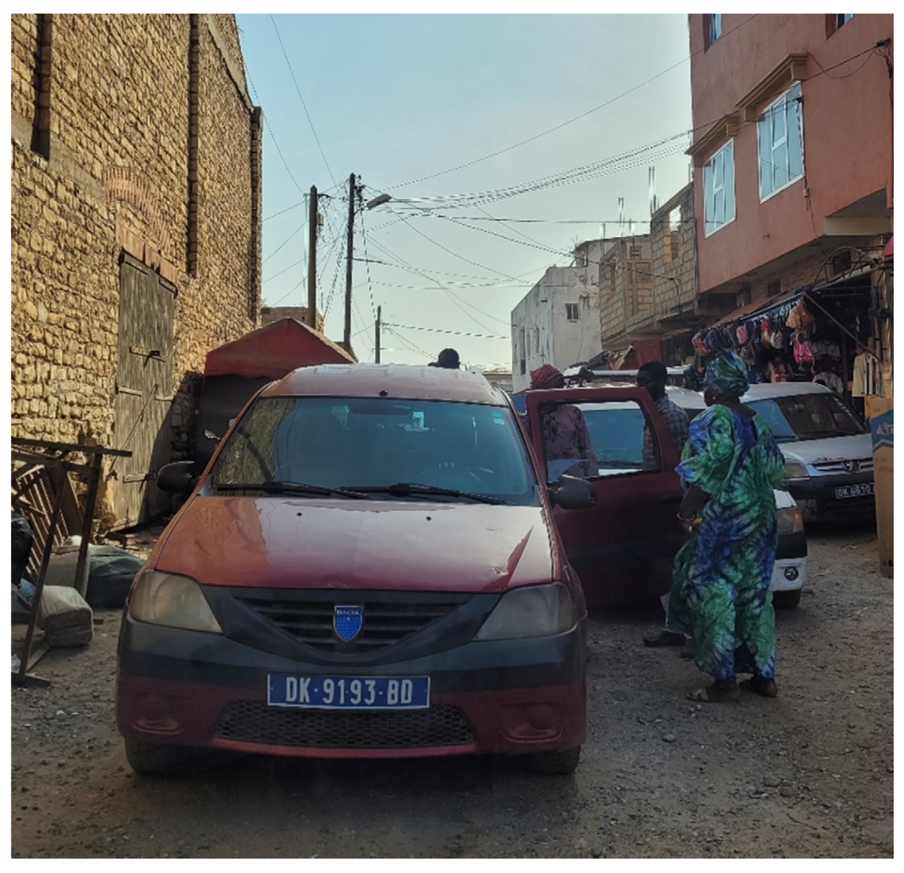
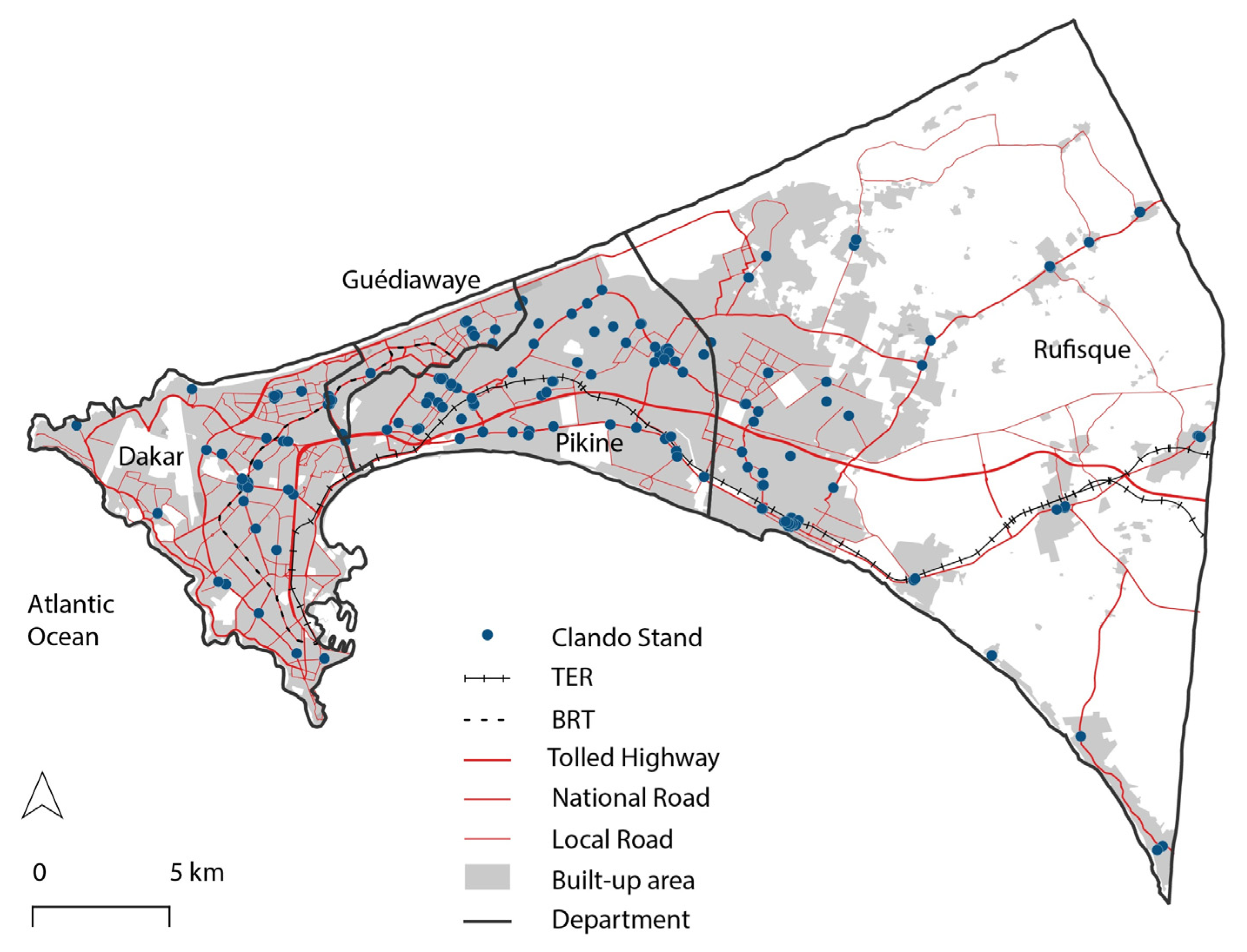
4.2. Clandos Coverage and Organization

Despite the uncertainty that is due to the non-legal nature of their activity, the Clandos have developed a durable organizational system. It is based on a strong spatial presence, embodied by the stands. This organization based on stands, fixed routes, and fares means residents are familiar with the Clandos. The stands have also provided an opportunity for the drivers’ collective to be set up. Most stands are managed by an association of affiliated Clando operators. Many of the stands are officially registered with the local administration. For half of the stands, their organization even takes the form of an economic interest grouping.

4.2.1. A Strong Spatial Presence

The census identified 169 stands, 70% of which are located in the outlying departments of Pikine and Rufisque. In relation to the number of residents, there are three times more stands in Rufisque than in Dakar (see Table 2).
Figure 4 shows the spatial distribution of the stands. They are generally located near an easily identifiable facility, such as a gas stand, a market, a mosque, or a pharmacy. Most of the time they are unmarked. The vehicles take over the area, parking on the sidewalks, at the side of the road, or on nearby vacant lots. However, some occupy spaces close to the road, which have been made available by the municipality or belong to a private stakeholder. Some of the stands have existed for a long time. In Rufisque, the situation is different because of a more recent urbanization. A third of the stands are less than 12 years old.
The Clandos stands are generally located near a public transport stop. In 80% of cases, the nearest stop is less than 2 minutes’ walk away, facilitating intermodality involving transfers to higher-capacity modes. AFTU buses connect to 92% of the stands, DDD buses to 61% and Ndiaga Ndiaye buses to 49%. Clandos, which generally consist of five- to seven-seater vehicles, have an advantage over larger vehicles. Even when they are located in areas where travel demand is limited, they can provide a service that is acceptable to the user in terms of waiting time and comfort. The use of Clandos by residents of the outskirts is not only due to the fact that they are established in the area, but also because of their intrinsic qualities: frequency, ability to carry luggage, comfort, availability, etc. During the questionnaire survey, the stand managers confirmed this availability, citing the fact that Clandos operate at night and do their best to continue to run during flooding.
The proximity between Clando stands and public transport stops also shows that the Clandos are not the only modes present in the outskirts, even the most remote ones. The Cars Rapides, the motorcycle taxis and the yellow and black taxis are present in the vicinity of the Clando stands (respectively, 37%, 29%, and 28%). When they are present, these three modes also compete with the Clandos for services within the department. In Pikine and Rufisque, green and white taxis (which are a recent creation that is supposed to replace the Clandos) and minicars were less frequently observed (8% and 7%, respectively).

4.2.2. Routes with a Variety of Functions

The survey identified nearly 300 fixed routes, with an average of roughly two routes per stand. Not all the routes fulfill the same function. Short-distance routes, with fares ranging from CFAF 100 to 250, account for more than half of all the routes. These are feeder routes to public transport stops and medium-distance routes that connect two urban areas a few kilometers apart. In Pikine, nearly two-thirds of the routes are short, revealing a multi-oriented network with many destinations remaining within the department. Conversely, when the fares on routes exceed CFAF 750, the Clando is in competition with other public transport modes for long-distance trips along main axes. These long-distance routes account for just under a quarter of the routes in the Dakar region. Their share rises to more than 30% in the department of Dakar, revealing the competitive positioning of the Clandos that are based in the central department.
The flexible and responsive spatial organization of the stands suggests the existence of several types of service. The Clandos are potentially in competition with larger vehicles on the main roads between Dakar and the periphery. More frequently, however, they are complementary, operating within the departments for local trips, or as a feeder service to higher-capacity modes. The varied roles played by Clando services as shown by the routes are confirmed by the results of the household travel survey.

4.3. Varied Use of the Clandos

Clandos account for a significant share of the public transport use of those living in the peripheral departments (Figure 5). For trips in which the Clando is the only mode used, it accounts for a quarter of the public transport trips made by the residents of Guédiawaye and Rufisque. The Clando is also used for intermodal trips, particularly in Pikine where such intermodal trips account for almost half of all Clando trips. In all the other departments, Clandos are used overwhelmingly as a single mode.

4.3.1. The Role of Clandos as a Feeder Mode to Buses

The function of operating as a feeder mode to higher-capacity modes (which we have assessed here on the basis of the proportion of Clando trips, where the mode is used in combination with another mode) accounts for 32% of all Clando trips. They contribute to long-distance trips, between one department to another mainly for work-related purposes, and mostly made by men. Clandos thus help to bring users closer to other modes of public transport, especially the inhabitants of Pikine, but this function is also very important in the other departments. They avoid the need for bus users to make long access and egress journeys on foot, acting as a feeder for DDD, AFTU, Ndiaga Ndiaye, and sometimes Cars Rapides routes.
In addition, single-mode Clando trips between one department and another account for only 15% of all single-mode Clando trips. In comparison, 35% of all public transport trips are between different departments. These long single-mode Clando trips only represent a small proportion of the travel market served by the Clandos.

4.3.2. The Dominant Role of Clandos: Local and Medium-Distance Services

Trips made entirely by Clando are the shortest public transport trips, measured both in time (22 min) and distance (2.2 km as the crow flies). For local use, Clandos are used for trips within the outlying departments, more frequently by women, for a variety of purposes related to domestic needs, social life, and trips made during the working day, although they are less often used for commuting trips.
Clandos are often used for daily activities aside from professional activities. When people use public transport to go to the public dispensary, to the market, and for formalities, it is frequently a Clando (Table 3). For higher-level health services, such as hospitals and clinics, the distances are generally longer, which limits the number of single-mode Clando trips and frequently requires an intermodal trip. Likewise, single-mode Clando trips are responsible for a relatively small proportion of commuting trips because of the greater distances involved, their frequency, and the expense involved.
With the exception of shopping at a market, the activities in question are not regular, but they are nevertheless an essential part of daily life. Walking is also widely used. The choice of a Clando may be linked to its better comfort when users are tired or ill, or to the fact that it is convenient in certain cases (bringing goods back from the market), or simply because distances are too long to be covered on foot.

5. Discussion and Conclusions

Our research focused on the role of clandestine collective taxis in the mobility of the residents of Dakar’s peripheries. Through the analysis of an HTS and a survey on Clando stands, it provides insights into issues that have received little attention, in spite of their importance. These questions are all the more pressing as policies in rapidly expanding cities are struggling to address the mobility issues they are facing in their peripheries.
Analyses based on the HTS reveal that the peripheral areas exhibit specific daily mobility practices. Walking is widely used in the region of Dakar, and its use is even more intense in the outskirts. In the department of Rufisque, which is the most distant, walking accounts for 79% of the modal share. Mobility is an imperative in situations where people experience poverty, whether for access to essential services or to jobs. However, the use of public transport remains limited in the outskirts of Dakar, both because services do not always match the population’s needs and because individuals have limited room for maneuver in their daily lives because of low incomes. In this context, the services provided by unlicensed Clandos are universally acknowledged by the population, but they remain unrecognized by the authorities.
However, their adverse impacts, such as the pollution caused by the age of the vehicles and the difficult working conditions of the drivers, should not be overlooked. While not within the scope of this research, these aspects of Clandos’ activity require further study. Other further research could compare Clandos and other public transport modes in terms of quality of service, which is often poor in Dakar, both in vehicles at stops and interchange stations [43,50]. Different methods could be used, with the help of mystery shoppers [51] or specific user surveys [52]. This research would assess the potential benefits and possible drawbacks of regularizing the activity of Clandos for the user. It would also assess the impact of regularizing on the quality of service (e.g., issuing licenses, renewing the fleet, fixing a set of rules that do not compromise their flexibility, etc.).
Despite various limitations of this work, some lessons can be learned about the role of Clandos in the mobility of residents of the Dakar peripheries.

5.1. The Dual Role of the Clandos in the Outskirts

The results of the HTS show that Clandos play a dual role, which is corroborated by the study of the location of their stands and the structuring of their routes.
In the first case, Clandos are used for long trips, connecting the urban peripheries to central areas. They are significantly more expensive than buses but provide better quality of service. In many cases, however, Clandos are only used for part of the trip and are used as a feeder mode to or from buses. These intermodal trips are also expensive and time-consuming for the user, as they involve the use of a sequence of different modes. These trips consist mainly of commuting trips, made primarily by men. Clandos avoid long access and egress journeys on foot and help to increase the ridership of the buses.
In the second case, the Clandos are used for internal trips within peripheral departments, which are often shorter and less expensive. The users form a fairly diverse group, with women being over-represented along with individuals working in the informal economy and schoolchildren. Women use Clandos for various purposes related to domestic needs, to work, or to social life. Since they do not depend on other forms of public transport, these more local Clandos trips appear to outnumber the others. Their comfort, their convenience, and the possibility of covering distances that are difficult to achieve on foot mean they can reduce mobility constraints, but this medium-distance mobility is nevertheless expensive for households: Clando use is often irregular and restricted to certain types of trips.

5.2. Clandos, a Support for Daily Life in the Outskirts?

As highlighted by the Clando stands survey, the operation of the Clandos is both flexible and structured, with an organization centered on a large number of conspicuously located stands and fixed routes with different functions. It is able to adapt to the mobility needs of the residents of the peripheral zones. At the micro-local scale, walking is nevertheless the most appropriate and widely used mode. The Clandos have a neighborhood presence, and operate within their department or as a feeder service to higher-capacity transport modes. They function as an intermediate mode of transport between conventional public transport on the one hand and walking and private modes on the other. The spatial distribution of their stands reveals the local presence of their activity. The stands are most often located near service or activity centers and are able to meet a variety of mobility needs. By the nature of the services they offer, the Clandos greatly enhance urban livability for the inhabitants of the periphery, allowing them to access the motorized transport necessary for social activities outside their neighborhood of residence.
In view of the diversity of functions that the Clandos perform, the role of feeder mode assigned to them at best by the public authorities seems simplistic. It does not make it possible to make the best use of them with a view to achieving urban development that is more polycentric and better balanced. On the contrary, a comprehensive policy that seeks to ensure the best possible travel conditions for city dwellers requires that all mobility patterns be taken into account, regardless of where people live and what forms of public transport are in place.
Currently, decision-makers are focusing on organizing public transport around the TER and BRT. In this perspective, informal modes such as Clandos are doomed to vanish, on the grounds that they compete with high-capacity transport. However, the role of the Clandos as a complementary mode, for both feeder services to public transport stops and for internal trips within a peripheral department, seems to offset the role they play in generating congestion. The Clandos help to provide occasional or more regular motorized mobility to the inhabitants of peripheral areas who need this mobility to carry out their daily activities. The results obtained in Dakar contribute to the case studies on the demand for informal transport in large cities of the Global South. They fuel the academic discourse and provide elements for public action concerning the definition and implementation of a transport supply that is adapted to the needs of the inhabitants of the peripheries. From the standpoint of sustainable mobility, and from both the social and environmental perspectives, better recognition of the role of each mode of transport, and in particular that of the Clandos, seems necessary. Such recognition would make it possible to take better advantage of their unique strengths and capabilities while limiting their adverse impacts (cost, pollution, etc.), and to enable them to play a full role in supporting mobility and daily life. These considerations must be incorporated into a more comprehensive analysis of the urbanization of peripheral areas and the need for public action to address transport and urban planning in a joined-up way.

Author Contributions

Conceptualization, G.L., P.P., M.D. and P.S.; methodology, G.L., P.P., M.D. and P.S.; software, D.C., G.L. and P.P.; validation, G.L. and P.P.; formal analysis, G.L., D.C. and P.P.; investigation, G.L., D.C., P.P., M.D. and P.S.; resources, M.D. and P.S.; data curation, G.L. and P.P., writing—original draft preparation, G.L., D.C., P.P., M.D. and P.S.; writing—review and editing, G.L. and P.P.; visualization, G.L. and P.P.; supervision, G.L. and P.P.; project administration, G.L., P.P., M.D. and P.S.; funding acquisition, G.L. and P.P. All authors have read and agreed to the published version of the manuscript.

Funding

This research was funded by École Nationale des Travaux Publics de l’État (ENTPE), grant Taxis-Clandos.

Institutional Review Board Statement

Not applicable.

Informed Consent Statement

Informed consent was obtained from all subjects involved in the study.

Data Availability Statement

Restrictions apply to the availability of EMTASUD 2015 micro-data. These data were obtained from CETUD and are available from CETUD with its permission. Restrictions apply to the availability of Clando survey micro-data. These data are property of the funding agency.

Conflicts of Interest

The authors declare no conflict of interest.

References

  1. UN-Habitat. The State of African Cities 2014. Re-Imagining Sustainable Urban Transitions; UN-Habitat: Nairobi, Kenya, 2014. [Google Scholar]
  2. Behrens, R.; Saddier, S.; Pickup, L.; Durant, T. A literature review to establish the ‘state of knowledge’ and appraisal of gaps requiring further research. In Transitions—Informal Transport Compendium Report; Project Report HVT/044 for UKAid; IMC Worldwide: London, UK, 2021. [Google Scholar]
  3. Behrens, R.; McCormick, D.; Mfinanga, D. Paratransit in African Cities: Operations, Regulation and Reform; Routledge: New York, NY, USA, 2016. [Google Scholar]
  4. Cervero, R. Informal Transport in the Developing World; UN-Habitat: Nairobi, Kenya, 2000. [Google Scholar]
  5. Dimitriou, H.; Gakenheimer, R. (Eds.) Urban Transport in the Developing World: A Handbook of Policy and Practice; Edward Elgar Publishing: Cheltenham, UK, 2011. [Google Scholar]
  6. Flyvbjerg, B. Five misunderstandings about case-study research. Qual. Inq. 2006, 12, 219–245. [Google Scholar] [CrossRef] [Green Version]
  7. Kumar, A.; Diou, C. The Dakar Bus Renewal Scheme: Before and After. In Sub-Saharan Africa Transport Policy Program (SSATP) Discussion Paper; World Bank: Washington, DC, USA, 2010. [Google Scholar]
  8. Diaw, M. La Restructuration du Système du Transport Urbain de Dakar: Quel Rôle pour les Taxis Collectifs «Clando»? CODATU: Lyon, France, 2020; Available online: https://www.codatu.org/ (accessed on 15 April 2022).
  9. Diaz Olvera, L.; Plat, D.; Pochet, P. The puzzle of mobility and access to the city in Sub-Saharan Africa. J. Transp. Geogr. 2013, 32, 56–64. [Google Scholar] [CrossRef] [Green Version]
  10. Jerven, M.; Johnston, D. Statistical tragedy in Africa? Evaluating the database for African economic development. J. Dev. Stud. 2014, 51, 111–115. [Google Scholar] [CrossRef]
  11. Myers, G. African Cities: Alternative Visions of Urban Theory and Practice; Zed Books Ltd.: London, UK, 2011. [Google Scholar]
  12. Choplin, A. Matière Grise de L’urbain: La vie du Ciment en Afrique; MétisPresses: Genève, Switzerland, 2020. [Google Scholar]
  13. Lucas, K. Transport and social exclusion: Where are we now? Transp. Pol. 2012, 20, 105–113. [Google Scholar] [CrossRef]
  14. Oviedo, D.; Okyere, S.A.; Nieto, M.; Kita, M.; Kusi, L.F.; Yusuf, Y.; Koroma, B. Walking off the beaten path: Everyday walking environment and practices in informal settlements in Freetown. Res. Transp. Bus. Manag. 2021, 40, 100630. [Google Scholar] [CrossRef]
  15. Andreasen, M.H.; Møller-Jensen, L. Access to the city: Mobility patterns, transport and accessibility in peripheral settlements of Dar es Salaam. J. Transp. Geogr. 2017, 62, 20–29. [Google Scholar] [CrossRef] [Green Version]
  16. Salon, D.; Gulyani, S. Commuting in urban Kenya: Unpacking travel demand in large and small Kenyan cities. Sustainability 2019, 11, 3823. [Google Scholar] [CrossRef] [Green Version]
  17. Hernandez, D.O.; Titheridge, H. Mobilities of the periphery: Informality, access and social exclusion in the urban fringe in Colombia. J. Transp. Geogr. 2016, 55, 152–164. [Google Scholar] [CrossRef]
  18. Lucas, K.; Porter, G. Mobilities and livelihoods in urban development contexts: Introduction. J. Transp. Geogr. 2016, 55, 129–131. [Google Scholar] [CrossRef]
  19. CODATU. Paratransit: A Key Element in a Dual System, Technical Report. 2015. Available online: https://www.codatu.org/wp-content/uploads/transports_collec_artisanal_V03ecran_EN.pdf (accessed on 18 May 2022).
  20. Kumar, M.; Singh, S.; Ghate, A.T.; Pal, S.; Wilson, S.A. Informal public transport modes in India: A case study of five city regions. IATSS Res. 2016, 39, 102–109. [Google Scholar] [CrossRef] [Green Version]
  21. Diaz Olvera, L.; Plat, D.; Pochet, P. Looking for the obvious: Motorcycle taxi services in Sub-Saharan African cities. J. Transp. Geogr. 2020, 88, 102476. [Google Scholar] [CrossRef]
  22. Uteng, T.P.; Turner, J. Addressing the linkages between gender and transport in low- and middle-income countries. Sustainability 2019, 11, 4555. [Google Scholar] [CrossRef] [Green Version]
  23. Timera, M.B.; Diongue, M.; Sakho, P.; Spooner, D. Bus à Haut Niveau de Service (BRT) à Dakar. In Rapport de L’enquête D’évaluation de L’impact sur la Main-D’œuvre; UCAD: Dakar, Sénégal; GLI: Manchester, UK, 2020. [Google Scholar]
  24. Asimeng, E.T.; Asabare, S.B. Factors that determine paratransit drivers’ willingness to participate in formal bus services in an African city. Case Stud. Transp. Policy, 2022; in press. [Google Scholar] [CrossRef]
  25. Booysen, M.J.; Andersen, S.J.; Zeeman, A.S. Informal public transport in Sub-Saharan Africa as a vessel for novel Intelligent Transport Systems. In Proceedings of the 16th International IEEE Conference on Intelligent Transportation Systems (ITSC 2013), The Hague, The Netherlands, 6–9 October 2013; pp. 767–772. [Google Scholar]
  26. Bruun, E.; Del Mistro, R.; Venter, Y.; Mfinanga, D. The state of public transport systems in three Sub-Saharan African cities. In Paratransit in African Cities: Operations, Regulation and Reform; Behrens, R., McCormick, D., Mfinanga, D., Eds.; Routledge: New York, NY, USA, 2016; pp. 26–58. [Google Scholar]
  27. Del Mistro, R.; Behrens, R. Integrating the informal with the formal: An estimation of the impacts of a shift from paratransit line-haul to feeder service provision in Cape Town. Case Stud. Transp. Policy 2015, 3, 271–277. [Google Scholar] [CrossRef]
  28. Falchetta, G.; Noussan, M.; Hammad, A.T. Comparing paratransit in seven major African cities: An accessibility and network analysis. J. Transp. Geogr. 2021, 94, 103131. [Google Scholar] [CrossRef]
  29. Tichagwa, C.G. Unlicensed taxis in Zimbabwe’s urban areas: The case for legalising an informal urban transportation system. Dev. S. Afr. 2016, 33, 81–98. [Google Scholar] [CrossRef]
  30. Venter, C. The lurch towards formalisation: Lessons from the implementation of BRT in Johannesburg. S. Afr. Res. Transp. Econ. 2013, 39, 114–120. [Google Scholar] [CrossRef] [Green Version]
  31. Tembe, A.; Nakamura, F.; Tanaka, S.; Ariyoshi, R.; Miura, S. The demand for public buses in sub-Saharan African cities: Case studies from Maputo and Nairobi. IATSS Res. 2016, 43, 122–130. [Google Scholar] [CrossRef]
  32. Limi, A. Estimating the Demand for Informal Public Transport: Evidence from Antananarivo, Madagascar. In Policy Research Working Paper; World Bank Group: Washington, DC, USA, 2022. [Google Scholar]
  33. Evans, J.; O’Brien, J.; Ng, B.C. Towards a geography of informal transport: Mobility, infrastructure and urban sustainability from the back of a motorbike. Trans. Inst. Br. Geogr. 2018, 43, 674–688. [Google Scholar] [CrossRef]
  34. ANSD. Projections de la population. In Agence Nationale de la Statistique et de la Démographie; ANSD: Dakar, Sénégal, 2021. [Google Scholar]
  35. ANSD. Rapport définitif—Recensement général de la Population, de l’Habitat, de l’Agriculture et de l’Elevage—RGPHAE 2013. In Agence Nationale de la Statistique et de la Démographie; ANSD: Dakar, Sénégal, 2014. [Google Scholar]
  36. Sakho, P. La Production de la ville au Sénégal: Entre Mobilités Urbaines, Migrations Internes et Internationales. Volume 1. Rapport de Synthèse. Thèse d’Etat, Université Cheikh Anta Diop de Dakar, Dakar, Sénégal, 2014. [Google Scholar]
  37. Seck, S.M. Dynamique des Transports Collectifs Informels Dans les Mutations de L’espace Urbain à Dakar (Sénégal). Ph.D. Thesis, Université Assane Seck de Ziguinchor, Ziguinchor, Senegal, 2021. [Google Scholar]
  38. Diongue, M.; Sakho, P. L’arrangement territorial des périphéries métropolitaines: Cas de Sangalkam et de Sébikhotane (Dakar, Sénégal). In Revue Espaces et Sociétés en Mutations (ESM); Presses Universitaires de Dakar: Dakar, Sénégal, 2016; Volume 2. [Google Scholar]
  39. Lombard, J.; Sakho, P.; Bruez, F.; Baillon, A. Les rues de Dakar: Espaces de négociation des transports collectifs. Autrepart 2004, 32, 115–134. [Google Scholar] [CrossRef] [Green Version]
  40. Godard, X. D comme Dakar ou le bilan mitigé d’une ville-pilote. In Les Transports et la Ville en Afrique au sud du Sahara; Godard, X., Ed.; Karthala-Inrets: Paris, France, 2002; pp. 57–72. [Google Scholar]
  41. Lombard, J. Le monde des transports sénégalais. In Ancrage Local et Développement International; IRD Editions: Marseille, France, 2015. [Google Scholar]
  42. Lesteven, G.; Quillerier, T. Study of Informal Passenger Transport Reforms in Sub-Saharan Africa. In Dakar Case Study, Unpublished Report for the SSATP; World Bank Group: Washington, DC, USA, 2021. [Google Scholar]
  43. Sitrass-Curem. Enquête sur la mobilité, le transport et l’accès aux services urbains dans l’agglomération de Dakar. In Rapport D’analyse Final pour le Compte du Cetud; Sitrass: Lyon, France; Curem: Dakar, Sénégal, 2016. [Google Scholar]
  44. Lammoglia, A. Analyse et Modelisation Multi-Agents de Transports Flexibles. Comparaison de Services Français et Sénégalais. Ph.D. Thesis, Université d’Avignon et des Pays du Vaucluse, Avignon, France, Université Cheikh Anta Diop de Dakar, Dakar, Sénégal, 2013. [Google Scholar]
  45. Diongue, M.; Cissokho, D.; Sakho, P.; Lesteven, G.; Pochet, P. Projet Taxis—Clandos; Rapport Final; Institut de la Gouvernance Territoriale (IGT): Dakar, Sénégal; UCAD: Dakar, Sénégal; en Partenariat avec le LAET—ENTPE—Université de Lyon Dakar, Sénégal: Vaulx-en-Velin, France, 2021. [Google Scholar]
  46. Diaz Olvera, L.; Plat, D.; Pochet, P. Access to the car in the cities of Sub-Saharan Africa: Practices and users in Dakar. Flux 2020, 119–120, 73–89. [Google Scholar] [CrossRef]
  47. Faye, D. Urbanisation et dynamique des transports informels et des mobilités dans les villes secondaires sénégalaises: Les cas de Touba, Thiès et Saint Louis. In Thèse de Géographie; Université Michel de Montaigne—Bordeaux III: Pessac, France, 2013. [Google Scholar]
  48. Lombard, J. Enjeux privés dans le transport 2021 public d’Abidjan et de Dakar. Géocarrefour 2006, 81, 167–174. [Google Scholar] [CrossRef] [Green Version]
  49. Sakho, P.; Camara, A. Accès à la ville, entre mobilité contrainte des plus aisés et assignation territoriale des plus pauvres. Le cas de Pikine, dans la banlieue de Dakar. Ann. Fac. Lett. Sci. Hum. 2013, 48, 108–125. [Google Scholar]
  50. Filho, R.D.O.; Ribeiro, R.G.; Thiam, M.K. A comparative study of the organization of alternative transport in the cities of Rio de Janeiro and Dakar. Case Stud. Transp. Policy 2015, 3, 278–284. [Google Scholar] [CrossRef]
  51. Barabino, B. Automatic recognition of “low quality” vehicles and bus stops in bus services. Public Transp. 2018, 10, 257–289. [Google Scholar] [CrossRef]
  52. Sharma, D.; Pandit, D. Determining the level of service measures to evaluate service quality of fixed-route shared motorized paratransit services. Transp. Pol. 2021, 100, 176–186. [Google Scholar] [CrossRef]
Figure 1. Clando at a stand in Rufisque (photo credit: G. Lesteven, November 2021).
Sustainability 14 06769 g001
Figure 2. Distribution of households on the basis of per capita income quintiles according to their department of residence (%). Note: per capita income: total household income divided by the number of people in the household. Q1: the 20% of households with the lowest per capita income; and so on until Q5: the 20% of households with the highest per capita income. Source: EMTASUD 2015, processing by the authors.
Sustainability 14 06769 g002
Figure 3. Average number of trips by motorized modes, according to activity status and department of residence (population aged 11 and over, Monday to Friday). (a) By private car *. (b) By public transport. * Car (mainly), motorcycle, bicycle. Source: EMTASUD 2015, processing by the authors.
Sustainability 14 06769 g003
Figure 4. Location of the Clando stands in the region of Dakar (map by the authors).
Sustainability 14 06769 g004
Figure 5. Clando trips made as a single mode or in an intermodal trip as a percentage of all PT trips (population aged 11 years and over, from Monday to Friday). Note: Clandos used for intermodal trips: used in combination with another mode during the trip. Clandos used for single mode trips: without the use of another PT mode during the trip. Source: EMTASUD 2015. Processing by the authors.
Sustainability 14 06769 g005
Table 1. Average number of daily PT trips and percentage of intermodal PT trips * according to department of residence (population aged 11 and over, Monday to Friday).
Department of ResidenceNumber of PT TripsPercentage of PT Trips Which Are Intermodal *
Dakar0.856
Guédiawaye0.949
Pikine0.6419
Rufisque0.5217
Region of Dakar0.7311
* Consisting of more than one public transport leg. Source: EMTASUD 2015. Processing by the authors.
Table 2. Distribution of Clando stands in the region of Dakar.
DepartmentNumber of Stands% of StandsNumber of Stands Per 10,000 Inhabitants
Dakar36210.31
Guédiawaye1590.46
Pikine65390.56
Rufisque53311.08
Region of Dakar1691000.54
Source: Clando Survey 2021–2022.
Table 3. Typical use of PT and Clandos for accessing places of work and various services or facilities (%).
Percentage of Individuals Traveling by PT Of Which: Percentage of Individuals Using Clando as a Single Mode
(i) Access to work
Place of work489
(ii) Access to services
Food market2133
Public dispensary2824
Private dispensary3712
Public hospital6913
Private clinic5113
Town hall3032
Post office1624
Scope: (i) all workers not working at home; (ii) households reporting that they use the service or facility. Table drawn up by the authors based on Sitrass–Curem (2016), data from EMTASUD 2015.
Publisher’s Note: MDPI stays neutral with regard to jurisdictional claims in published maps and institutional affiliations.

