Article

Modular Design of Bioretention Systems for Sustainable Stormwater Management under Drivers of Urbanization and Climate Change

by
Marina Batalini de Macedo
1,*,
Marcus Nóbrega Gomes Júnior
1,
Vivian Jochelavicius
2,
Thalita Raquel Pereira de Oliveira
1 and
Eduardo Mario Mendiondo
1
1
Hydraulic Engineering and Sanitation, Sao Carlos School of Engineering, University of Sao Paulo, Av. Trabalhador Sãocarlense, 400 CP 359, São Carlos 13566-590, SP, Brazil
2
Sao Carlos School of Engineering, University of Sao Paulo, Av. Trabalhador Sãocarlense, 400 CP 359, São Carlos 13566-590, SP, Brazil
*
Author to whom correspondence should be addressed.
Sustainability 2022, 14(11), 6799; https://doi.org/10.3390/su14116799
Submission received: 10 March 2022 / Revised: 5 May 2022 / Accepted: 7 May 2022 / Published: 1 June 2022
(This article belongs to the Special Issue Green Technologies for Urban Water Management)

Abstract

:
The increase in urbanization and climate change projections point to a worsening of floods and urban river contamination. Cities need to adopt adaptive urban drainage measures capable of mitigating these drivers of change. This study presents a practical methodology for a modular design of bioretention systems incorporating land use and climate change into existing sizing methods. Additionally, a sensitivity analysis for these methods was performed. The methodology was applied to a case study in the city of Sao Carlos, SP, Brazil. Three application scales were evaluated: property scale (PS), street scale (SS) and neighborhood scale (NS) for three temporal scenarios: current, 2015–2050 and 2050–2100. The choice of the sizing method was the factor with greatest influence on the final bioretention performance, as it considerably affected the surface areas designed, followed by the hydraulic conductivity of the filtering media. When analyzing the sensitivity of the parameters for each method, the runoff coefficient and the daily precipitation with 90% probability were identified as the most sensitive parameters. For the period 2050–2100, there was an increase of up to 2×, 2.5× and 4× in inflow for PS, SS and NS, respectively. However and despite the great uncertainty of future drivers, bioretention performance would remain almost constant in future periods due to modular design.

Graphical Abstract

1. Introduction

Rapid urbanization causes structural and environmental changes in urban catchments, reducing soil infiltration and increasing the amount of pollutant build-up [1,2,3]. As a result of these changes, there is a significant increase in runoff, converting the natural hydrological cycle into an urban problem. Extreme rainfall events are precursors of risk to the population [4,5], with greater vulnerability to floods and landslides.
Considering the climate change scenarios, extreme events and their consequences tend to become more frequent [6,7]. Increases in rainfall volume, rainfall intensity and natural disaster incidents are consequences predicted by the studies [8]. The additional stress on infrastructure, construction, environmental conditions, and the large population concentration in urban centers make cities one of the main locals where climate change impacts occur. As an example, for the United Kingdom, ref. [9] estimates that the combination of climate change and population growth in cities will cause an increase in rainfall flood risk for over 1.2 million people.
After discussing the importance of cities in the climate change context, both as a contributor and suffering the consequences, the 40 largest cities in the world formed the C40 group to discuss and exchange public management actions and policies aiming to reduce the impacts generated and suffered by them. In the report released by the group in 2014 [10], 90% of the cities that are part of the group indicate that climate change represents significant risks to their cities, the main ones associated with flooding and water stress. In addition, they also point to drainage as the key to flood risk management, in which adaptive urban drainage systems occupy the third place in the most performed actions by the group.
Several names are given to this new approach, such as Nature-based Solutions (NbS) for urban drainage, Sustainable Urban Drainage Systems (SuDS), Water Sensitive Urban Drainage (WSUD), Green Infrastructure, Sponge Cities and Low Impact Development (LID) practices [11,12]. In this study, we will use LID terminology. This approach aims to re-establish the natural hydrological cycle, focusing on increasing runoff infiltration and treatment, thus contributing to the control of floods and diffuse pollution [11,12]. Common examples of structural LID practices are green roofs, permeable pavements and bioretention (also known as rain gardens), among others. Bioretention has been of great interest to practitioners and new studies due to the range of water treatment processes involved in it [13].
Knowing that both urbanization and climate change generate an exceeding runoff in cities, several studies have been conducted to investigate the magnitude of each of these changes in urban drainage systems. In this sense, refs. [14,15] made a joint analysis of the effects of urbanization and climate change on LID practices for two watersheds in Indiana, USA, using the L-THIA-LID 2.1 model. For watershed 2, both urbanization and climate change contributed to the increase in the runoff and pollutants generated, being intensified in the scenario with the two drivers of change acting together.
Ref. [16] used a simple stormwater model (SGWATER), to assess the runoff and pollutant load sensitivity due to changes in impervious cover, rainfall volume and intensity. The results obtained suggested that the runoff generation is more sensitive to increasing urbanization than changes in rainfall patterns. Similar analyses were obtained by the study of [17], which was conducted in a city in Sweden, with simulations over 15 months. The results obtained were that climate change and urbanization, jointly and separately, increased the peak flows and runoff volume in a city, increasing the flood risk.
Adaptive urban drainage projects need to consider both drivers of change from the conception and design stage. In some locations, guidelines already propose the update of design storm through Intensity–Duration–Frequency (IDF) curves incorporating the non-stationary effects of climate change, aiming at infrastructure sizing, such as in Europe and New York State [18,19,20]. However, there are still doubts concerning what are the main parameters needing greater attention and effort during the design stage of adaptive LID practices for urban drainage systems when aiming to address future scenarios with drivers of change. Currently, several design methods are suggested in the guidelines, accounting for different input variables, initial parameters and different characteristics of design storm, besides uncertainties in the determination of some physical parameters, generating variability in the results of the system’s performance. Therefore, there is a need for further studies that help to clarify these doubts and reduce the uncertainties in the design stage.
This paper aims to present a methodological sequence for the incorporation of climate and urbanization changes in the design of adaptive urban drainage structures, more specifically in a bioretention system. Considering that it is necessary to design structures to reduce risks to the population while minimizing construction costs, a modular design approach is also presented here. Changes in rainfall patterns are considered since the design from the updating of IDF curves for the future climate, changing the design storm. On the other hand, scenarios of future land use are incorporated through changes in the values of the rain-flow transformation coefficients in the infiltration methods. The methodology was applied to the city of São Carlos (a representative mid-sized Brazilian city) located in southeastern Brazil, under a subtropical climate.
In addition, as a way of assessing the uncertainties that exist in the different methods and contributing to identifying the parameters and input variables requiring more attention in the systems considering future scenarios, a sensitivity analysis was performed. The parameters and input variables involved in different sizing methods evaluated were chosen considering urbanization (runoff coefficient, curve number, % impervious area, soil type), climate (IDF, rain duration, temporal distribution pattern) and structure aging (hydraulic conductivity). Finally, a simulation of future scenarios was carried out.

2. Methodology

The study methodology follows the sequence shown in Figure 1: (1) To select discrete ranges that represent the application site and design methods, allowing identification of the input variables and initial design parameters related to urbanization and climate patterns; (2) To select discrete ranges regarding future urbanization, climate patterns and infrastructure aging; (3) To perform global sensitivity analysis and identify the main parameters and input variables affecting the performance of the system; (4) To evaluate the efficiency of the adaptive urban drainage structure, considering future scenarios with different drivers of change and intervention.

2.1. Parameters and Input Variables Representing Application Site and Design Methods

2.1.1. Study Area and Application Scales

The design of adaptive urban drainage practices, considering the drivers of change in future scenarios, was proposed for the Mineirinho Creek catchment, one of the catchments that form the urban watershed of the city of São Carlos City, SP, Brazil (Figure 2), located in the southeast of the country.
For the city of São Carlos, the climate is classified as Cfa (humid summer subtropical climate) for the Köppen-Geiger climate classification. According to the climatological normal, São Carlos presents an annual average rainfall of 1494.2 mm and an average daily temperature of 20.6 °C [21]. The city has its urban limits within the Monjolinho watershed, having a total area of 76.8 km2 and a population density of 194.53 inh./km2. The city counts several points of recurrent flooding—the main ones located in areas of high commercial density. Therefore, the floods cause significant economic damage to the city [22,23]. One of the recurring flooding points is in the Mineirinho Creek catchment outlet (pictures of floods damages provided in Supplementary Material—Figure S1). In this location, businesses such as a car dealership, shopping mall, restaurants and construction store are located. In addition, the Mineirinho Creek catchment presents itself as a diverse peri-urban area, with sites reserved for the preservation of its springs, and at the same time, with a predicted expansion of housing land division [24]. Due to its diverse characteristics and contribution to flooding problems in the city of São Carlos, this area was selected to design adaptive drainage structures with drivers of change.
When it comes to adaptive urban drainage measures, they can be applied at three major scales: property/lot scale, street scale and neighborhood scale [25,26]. In this study, three bioretention structures were designed for the three application scales with the predicted increase in urbanization level (Figure 2). For the property scale and street scale, it was chosen the areas where there are bioretention systems installed on the campus of the University of São Paulo in São Carlos and with a predicted expansion of buildings. As for the neighborhood scale, due to the absence of bioretention implemented at this scale, a residential neighborhood was chosen in the same catchment, with little occupation at the present time, but with a forecast of future expansion.
The mitigation purposes used for the design were to increase the resilience to floods (runoff retention, peak flow attenuation and increase of the delay in the occurrence of peak flow), as well as an increase in the resilience to drought (recovery of runoff treated by bioretention for local non-potable use), since climate change can arise water scarcity problems to the city of São Carlos.

2.1.2. Simplified LID Practice Design and Pre-Sizing

Several sizing methods for bioretention have been proposed in the USA [27], Australia [26,28,29] and other countries [30,31] and are often used internationally. The most commonly used methods in Brazil and a summary of the design purposes and key parameters for each method are presented in Table 1. Details of each method can be found in their references.
From Table 1, it is possible to observe that the design methods with the purpose of mitigating rainfall extremes, such as runoff volumes and peak flows, present the design storm as main input data (obtained from the IDF curve for a specific duration and temporal distribution). In addition, the main parameters include rain-flow transformation coefficients, namely: surface runoff coefficient (C) of the Rational Method [32] (pp. 496–499) and the curve number (CN) of the Soil Conservation Service—Curve Number (SCS-CN) method [32] (pp. 147–152). These parameters vary depending on the land use type and are assigned to each location based on its level of urbanization.
Table 1. Comparison between internationally used sizing methods.
MethodDesign StormMitigation PurposeMain ParametersVariables AssumedSource
Bioretention manualQ90Water qualityAc, WQV, Rv, I, Khb, db, tb, FS, filtering media[27]
Exceedent volume *
Peak flow **
WSUD technical guidelinesIDFWater quality Ac, C, K, tchb, db[26,28,29]
Peak flow *
Envelope curve/rain methodIDF, PDFExceedent volumeAc, CQs, qs, filtering media[30,31]
Peak flow
BIRENICEIDFExceedent volumeAc, CN, nBioretention dimensions (flexible), filtering media[33]
Peak flow **
Water quality ***
Ac, catchment area; WQV, water quality volume; Rv, linear runoff coefficient; I, percentage of impervious area; K, permeability coefficient of the filtering media; hb, ponding depth; db, filtering media depth; tb, emptying time; FS, safety factor; C, runoff coefficient; Qs, outflow; L, length of the saturated area; Ab, bioretention surface area; CN, curve number coefficient; tc, time of concentration. * additional purpose; ** complementary simulation; *** restriction.
The modular design concept is presented in the proposal of BIRENICE [33]. It consists of sizing the adaptive urban drainage practice for long-term future scenarios, but in a way that its implementation is made modularly, for predefined time intervals. With this approach, it is possible to guarantee the safety of the structure, reduce the risk for the population, and, at the same time, amortize the construction and operational costs. To this end, the input data and parameters of each of the sizing methods can be updated to match future scenarios of both urbanization and rainfall patterns changes to predefined expansion intervals.
In this study, the sizing method was considered as an initial variable in the global sensitivity analysis, i.e., all of the sizing methods presented were used to determine the bioretention surface areas and their respective performances, jointly varying the parameters and input variables of each method, according to future urbanization scenarios, climate patterns and infrastructure aging. The bioretention dimensions other than the area were kept constant (Table 2).
The general design of the bioretention is presented in Figure 3. It contains three main layers: (1) a vegetation layer, with a predominance of species Dracaena reflexa, Complaya trilobata and Sanchezia nobilis adapted to variations in water availability and with potential for nitrogen removal [34]; (2) a filtering and storage layer, containing as filtering media a soil mix, with a mixture of 80% coarse sand and 20% local native soil (Red Oxisol + Yellow-Red Oxisol); and (3) a drainage layer, containing gravel and an underdrain. As one of the mitigation purposes is the recovery of stormwater for reuse, the bioretention was designed as a lined structure with a submerged zone to promote greater removal of pathogens and nutrients.

2.2. Parameters and Input Variables Representing Drivers of Change for Future Scenarios

2.2.1. Future Urbanization: Changes in Land Use

One of the main drivers of change for future scenarios to be considered in the design of urban drainage structures is the expansion of the urbanized area and, consequently, changes in land use. These modifications alter the soil water storage capacity, mostly contributing to the increase in the runoff generation. Therefore, the urbanization process alters peak flows and total runoff volume and should be considered in urban drainage structure designs to maintain efficiency over their lifetime. To incorporate these changes, an alternative is to update the value of runoff coefficient, CN or soil infiltration capacity (according to the infiltration method adopted). In the WSUD Technical Guidelines [26], for example, a correction factor in the value of the C is presented as a function of the return period (RP) used for the design storm. However, this method does not provide modular expansion of structures.
For this study, we propose to change the C and CN values from the predicted land-use types and expansion rates in different locations, based on the master plan of São Carlos city [24]. For each of the catchments, the final value of C or CN, for each time interval in the modular expansion was obtained from the weighting of the land use types with its respective area. The values of C and CN for the different land-use types and hydrological soil groups were obtained from [35].
The level of detail of the Brazilian soil maps and the costs for soil analysis sometimes leads to errors in the most correct classification of the soil type and its hydrological group. Therefore, since the CN varies according to the soil hydrological groups, these were also considered as a parameter of the sensitivity analysis.

2.2.2. Climate Change

In order to incorporate changes in rainfall patterns in the site due to climate change, it is proposed to update the IDF curves to generate design storms that are more compatible with future scenarios [36,37,38]. Several studies [19,39,40] have already recommended updating IDFs for this purpose. This procedure has been adopted in New York State and Belgium guidelines [18,20].
In this study, the IDFs were updated using the future maximum daily rainfall projected by a Regional Climate Model developed by INPE-PROJETA [41,42] for the region of São Carlos, Brazil, Eta-MIROC5. A bias correction procedure through power transformation and mapping distribution methods [43] was performed using the CMHyd program (Supplementary Material—Figure S2).
Even when performing bias correction, there is still great uncertainty in global and regional climate models, as well as in the bias correction method itself. These uncertainties should be considered in hydrological simulations. Ref. [44] proposes that instead of quantifying statistical uncertainties, it would be possible to deal with uncertainty scenarios, using various climate models and emission scenarios and applying different bias correction methods. Therefore, this study analyzed the variability of scenarios considering the RCM used for the RCP 4.5 and 8.5 radioactive forcing [41,45] and the two bias correction methods employed.
For the IDF curve construction, a probabilistic distribution model was used for extreme values that better suited the data set of future scenarios. The theoretical probability distribution was evaluated using the Kolgomorv–Smirnov test, with p-value hypothesis test and coefficient of determination [46]. Based on the aptitude of the empirical and theoretical combination regarding the statistical indicators and hypothesis tests, the Gumbel’s model was chosen, since it passed on the hypothesis and statistical indicators test for all scenario combinations (Supplementary material—Table S1) and is the most commonly used for building historical IDFs in Brazil.
In addition, the city of São Carlos presents itself as a partially gauged site—there is no sub-daily rainfall data collection with a timescale needed to construct the IDFs. Therefore, the sub-daily rainfall depths were obtained using disaggregation factors from [47] (Supplementary material—Table S2). Similar approaches were performed by [48,49,50]: They have also used estimates of the local distribution obtained for sites with sub-daily records to calculate parameters at sites where only daily rainfall is observed, considering the assumption of scale-invariant of rainfall intensity and duration. The disaggregation factors used in this study were proposed for the Gumbel distribution model, being an additional reason for choosing this extreme distribution model.
The design storm also requires the adoption of rainfall duration and a pattern of temporal distribution. Adopting different values of both can also lead to changes in the final performance of urban drainage systems [51]. Therefore, variations in these parameters were also adopted to assess sensitivity. For the rainfall duration it was adopted the values of 30 and 90 min (generally adopted in Brazilian urban drainage manuals [52]) and constant temporal distribution (according to the use of the rational method [32], Huff 1st quartile, and centralized alternated blocks [53].

2.2.3. Structure Aging

When thinking about mitigating impacts for future scenarios, the aging of the structure is a factor that should be considered from the design stage. Many of the adaptive urban drainage structures are based on infiltration principles to re-establish the hydrological cycle and filtration-based water treatment. Over time, the infiltration capacity is reduced due to clogging. If this process is not considered in the design, the structure may not work with the same performance for future scenarios or can even become obsolete.
In this study, the importance of clogging was evaluated from the sensitivity of the sized area and the performance of the bioretention to the hydraulic conductivity of the filtering media. Two hydraulic conductivity values were adopted, one representing the new structure Ksat,n = 468 mm/h, the theoretical value obtained by the weighted average of the hydraulic conductivity for each type of material used in the bioretention filtering media, and other representing the old structure, i.e., years after use (Ksat,o = 195 mm/h, value obtained experimentally for a bioretention after years of use). The sensitivity analysis was performed considering the combinations: (design parameter, simulation parameter) = (Ksat,n, Ksat,n), (Ksat,n Ksat,o), (Ksat,o, Ksat,n) and (Ksat,o, Ksat,o).

2.3. Simulation Model

The water flow module of the mathematical model proposed by [54] and adapted by [55] to simulate bioretention structures was used for the evaluation of the system’s performance, and quantification of the sensitivity analysis evaluation functions (presented in Section 2.4) and simulation of future scenarios. This model uses a process/physically based approach and has been proved to be efficient enough to simulate water flows in bioretention, for different configurations (with and without a submerged zone, lined and unlined) and for different mitigation purposes. Further details of the model and each of the equations representing the water mass balance and the state variables are presented in Supplementary Material (Tables S3 and S4). A summary of the parameters required in the model and the adopted values are presented in Table 2. In this study, the model was implemented in Python 3.8.
For this study, an automatic calibrator for the model was developed using genetic algorithms (from the Distributed Evolutionary Algorithms in Python library—DEAP 1.3.1) using the maximization of the average Nash–Sutcliffe efficiency index (NSE) to outflow through the underdrain and the depth of the water level in the ponding zone as the objective function. Six events monitored during the year 2019 in a bioretention box in a laboratory scale were used for the calibration process (three used for calibration and three for validation). The details of the laboratory experiments can be found in [56] and a summary is presented in Supplementary Material—Table S5. This bioretention box is used for research at the University of São Paulo, in the city of São Carlos and it was constructed with the same materials and configurations (soil mix, lined, with a saturated zone) proposed in the three application scales of this study, as presented in Figure 3. The events monitored in the laboratory simulated the runoff generation for the same urbanization conditions and current climate of the Mineirinho watershed. The final NSE values obtained for calibration was 0.74 and for validation it was 0.62. The parameters used in the calibration and its final value can be seen in Table 2.

2.4. Sensitivity Analysis and Evaluation Functions

A global sensitivity analysis was performed using the Morris screening method [57]. This method aims to identify the input variables and parameters that contribute significantly to the variations and uncertainties of the output, other than to determine the exact sensitivity of the model to a specific parameter or variable. In the Morris method, a discrete number of values are used for each parameter instead of acquiring directly from its distribution functions. This fits the case evaluated in this paper since most parameters related to the drivers of change have discrete intervals by nature.
According to [58,59], for a vector of base input parameters/variables X = (x1, x2, … xk), the determination of the elementary effect of the i-th parameter or input variable in the deviation of the evaluation function is given by Equation (1). Subsequently, the mean (μ) and standard deviation (σ) of the elementary effects of each range of parameters or input variables were computed according to Equation (2) (adapted by [59]) and Equation (3). The μ estimates the general effect of each parameter on the model output (in this case, in order to evaluate the influence on the performance of the bioretention from different design methods), and σ estimates higher-order effects, such as non-linearity and interaction with other parameters [57]. For parameters that have no numerical value (such as rain distribution, soil type, IDF period, urbanization period and urbanization level), only the differences were computed without delta weighting.
d i ( X ) = y ( x 1 ,   ,   x i 1 ,   x i + ,   x i + 1 ,   ,   x k ) y ( X )
μ i = 1 r j = 1 r | d i ( j ) |
σ i = 1 r 1 j = 1 r [ d i ( j ) 1 r j = 1 r d i ( j )   ] 2
where di(X) is the elementary effect of the i-th parameter; Δ is the difference between the base parameter or input variable and the evaluated value; y(X) is the evaluation function for the base parameters or input values; μi is the mean of the elementary effects of each parameter; r is the number of sample points in the parameter or input value space; di(j) is the elementary effect for input i using the j-th sample point; σi is the standard deviation of the elementary effects of each parameter.
Four evaluation functions were proposed (Equations (4)–(7)) in order to determine the effects of parameters and input variables on different design purposes of urban drainage structures, such as runoff retention, peak attenuation, peak delay and water reuse (representing the amount of water recovered by the underdrain, which can be reused in the future). These functions were used both for sensitivity analysis and to compare the performance of bioretention in future scenarios with different drivers of change.
E f f r r = V i n V o v e r V i n
E f f p e a k = Q p e a k , i n Q p e a k , o v e r Q p e a k , i n
E f f t i m e = t p e a k , i n t p e a k , o v e r t p e a k , i n
E f f w r = V o u t V i n
where Effrr [—] is the runoff retention efficiency; Vin [L3] is the total inflow volume; Vover [L3] is the total overflow volume; Effpeak [—] is the peak attenuation efficiency; Qpeak,in [L3T−1] is the maximum inflow value; Qpeak,over [L3T−1] is the maximum overflow value; Efftime [—] is the time delay efficiency; tpeak,in [T] is the duration of the event until the Qpeak,in; tpeak,over [T] is the duration of the event until the Qpeak,over; Effwr [—] is the water reuse efficiency; Vout [L3] is the total outflow volume.

3. Results and Discussion

3.1. Changes in Urbanization and Land Use

Three areas with different land use characteristics and application scales were selected to evaluate the implementation of bioretention systems with a modular design. The area a (Figure 2) is a property scale (PS), collecting water from a roof, i.e., land use already consolidated, not changing in future periods. For areas b and c (Figure 2), these represent street scale (SS) and neighborhood scale (NS), respectively, still under an urbanization process. The quantification of future land use for the intervals 2015–2050 and 2050–2100 is presented in Figure 4. The SS will present an urbanization of 30% for the interval 2015–2050 and 80% by 2100 [24]. For the NS, a faster urbanization is expected, with occupation of 80% by 2050 and 100% urbanized by 2100.
Table 3 presents the values of C and CN for the future scenarios of urbanization used in the design calculations. For the PS, since the bioretention receives water from a roof, there is no change in C and CN over time, therefore, the values C = 0.9 and CN = 98 were the same for all periods. For the SS and NS, the effects of urbanization in both parameters are more expressed. It is also possible to notice the influence of the soil type in the final CN values—for soils in hydrological group D, i.e., soils with less permeability, the impact of urbanization is lower than in soils with higher permeability—which suggests the importance of correctly determining correctly the type of soil (the influence in the bioretention design and performance are verified by the sensitivity analysis and simulation).
In addition, in order to simplify the analysis, all areas were considered with a constant time of concentration throughout the urbanization, as they are small catchments with drainage infrastructure already consolidated. For the PS, as it has a small roof, a time of concentration of 5 min was adopted. For SS and NS, the time of concentration of 15 and 20 min were adopted, respectively (values estimated by field evaluation).

3.2. Changes in Rainfall Pattern

Regarding the future scenario of climate change, IDF curve updates were made for the intervals 2015–2050 and 2050–2100, aiming at the modular design of adaptive urban drainage structures.
First, the historical IDF adopted in this study for the city of São Carlos was the one proposed by [51] (Table 4, without climate change) as an update of the IDF curve proposed by [47], with more recent observed data for maximum daily rainfall. The methodology used by [51] to update the IDF for the current scenario was the same used in this study. This IDF was used to size the bioretention structures in the current scenario. Further, the IDFs for the city of São Carlos were updated considering the climate change scenarios for the intervals 2015–2050 and 2050–2100.
The updated IDFs, with their range of variation considering different future scenario combinations, can be observed in the Supplementary Material (Figures S3 and S4); the numerical curve coefficients are presented in Table 4. One way to assess the change in rainfall intensities for future scenarios is to observe what would be the historical RP equivalent for a fixed design event. Therefore, considering a design rainfall of 5-years RP and a fixed duration of 30 min for the interval 2015–2050, its historical equivalent is of 2.5-years to 3.5-years RP (range considering the variability in the future scenario) and for the interval 2050–2100 its historical equivalent is of 1.4-year to 1.9-year RP. The same assessment was made for a design rainfall of 50-years RP and a fixed duration of 30 min. It was obtained a historical equivalent of 8.8-year to 11.5-years RP for the interval 2015–2050 and 4.7-years to 8.4-years RP for the interval 2050–2100. This change in the RP represents an increase in the frequency of occurrence for a design rainfall for RP 5.30 up to 2 and 3.6 times and for RP 50.30 up to 5.7 and 10.6 times, for the respective future intervals.
In order to observe if this behavior had significant changes when changing the duration of the rainfall event, the same assessment was made for daily events (a fixed duration of 1440 min). Increases up to 1.6 and 3.2 times for RP 5 years and up to 5.5 and 10 times for RP 50 years were noted for the respective future intervals, i.e., the same behavior was observed for longer durations.

3.3. Sensitivity Analysis

The parameters and input variables evaluated in the sensitivity analysis and their respective ranges are shown in Table 5. In total, 124,417 combinations were evaluated, representing bioretention structures sized for three application scales considering the current period and future scenarios with modular design, i.e., an increase of area per period.
To assist in the interpretation of the sensitivity analysis results and in the simulated hydrographs for the current and future scenarios, Figure 5 presents the values of Pearson’s linear correlation coefficients (r) obtained between the parameters representing the drivers of change for urbanization (CN, Urbanization level—UL) and climate (RP, rainfall intensity—irain), application scale (catchment area—Acat) and sized area (bioretention area—Ab), with the efficiencies of runoff retention (Effrr), peak flow attenuation (Effpeak), time delay (Efftime) and water reuse (Effwr), used as functions to evaluate the system’s performance, in addition to their own efficiencies.
As expected, it is possible to notice that the efficiencies are correlated with each other: Effrr and Effpeak presenting a stronger correlation (r = 0.96) and a lower correlation for Effwr with the others (ranging from 0.29 to 0.45). Regarding the parameters representing the future drivers of change, none of them showed a significant correlation with the performance when evaluated individually. The influences of the drivers of change on the performance of adaptive drainage measures must occur jointly (due to synergistic effects) or non-linearly. An analysis of the influence of these parameters considering all their combinations is presented later. Finally, it was observed a positive correlation between the sized area, Effrr and Effpeak (r = 0.48 and 0.51, respectively) and negative correlation with Effwr (r = −0.54). The greater the area of the bioretention, the greater the infiltrated volume, thus, the greater the runoff retention, also reducing overflow peaks. However, in relation to water reuse, the negative value of the correlation does not necessarily indicate a lower volume of water recovered by the underdrain, but rather a lower relationship between recovered volume and total inflow volume. This aspect will be further discussed in Section 3.4.
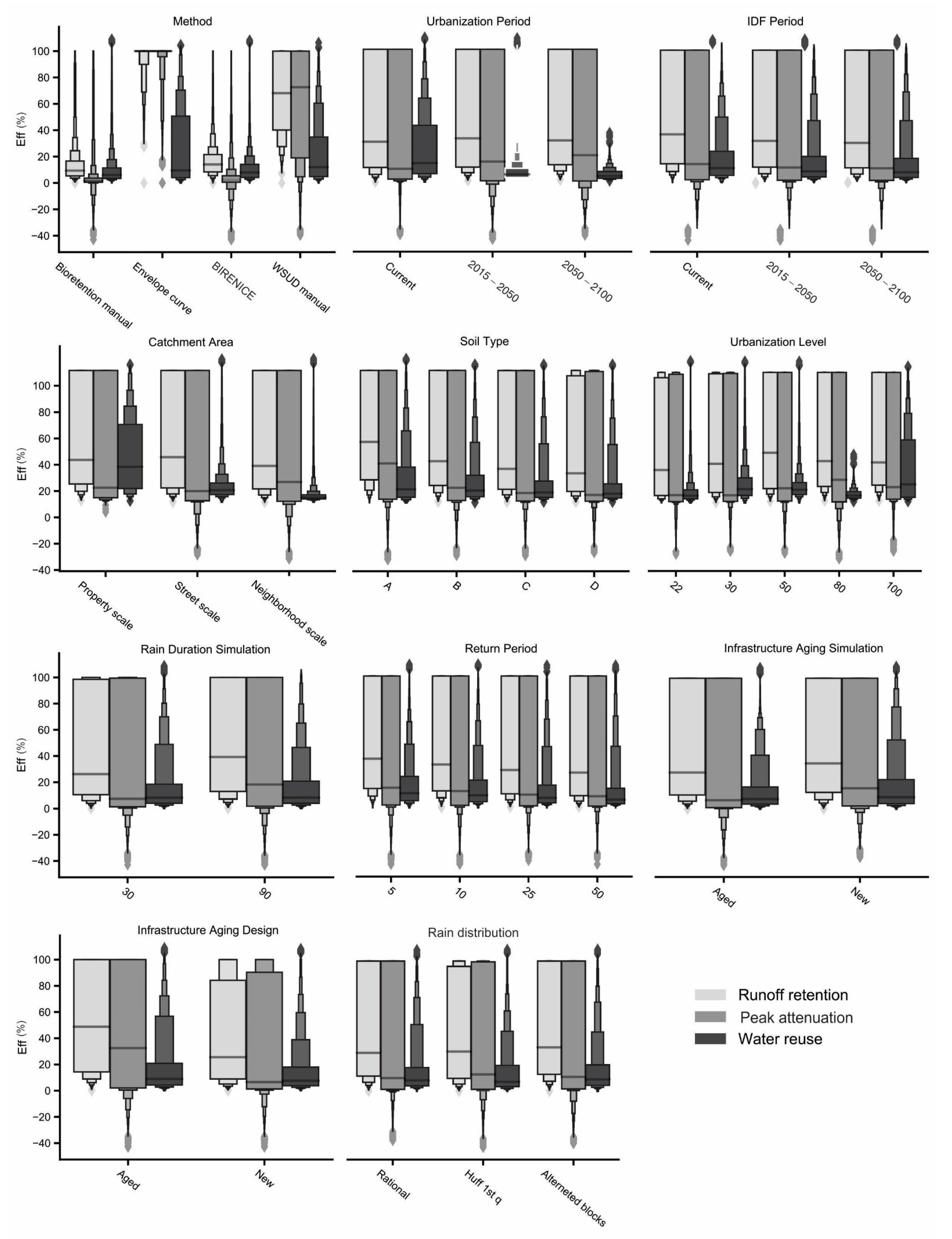
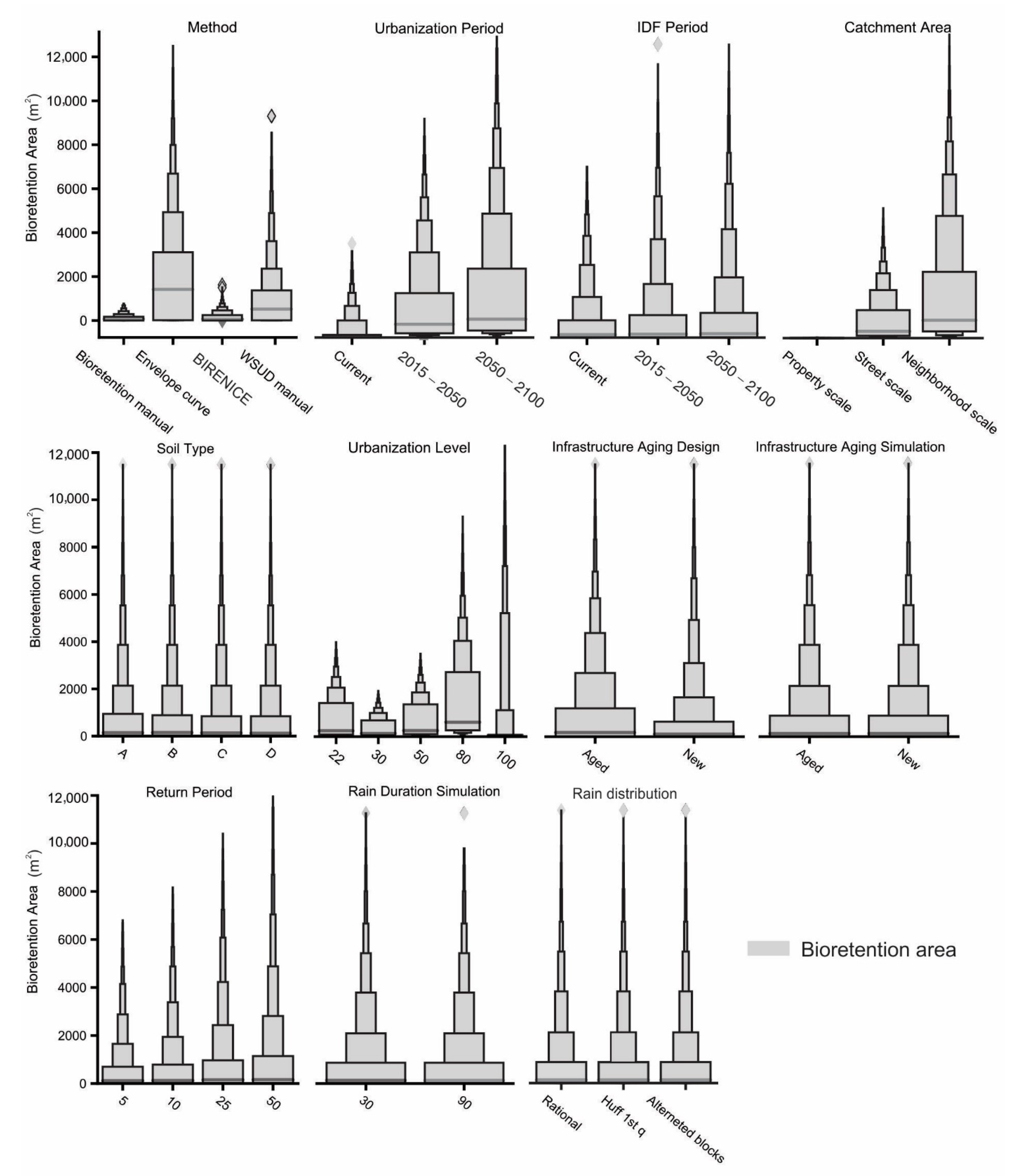
For all combinations evaluated, Figure 6, Figure 7 and Figure 8 show letter-value plots for the values of runoff retention efficiencies, peak flow attenuation, water reuse, time delay and sized area, respectively, grouped for each of the parameters or input variable analyzed. The letter-value plot is an adaptation of the boxplot for the non-parametric statistical representation of larger data series (usually >10,000) with a greater number of plotted quantiles, allowing better visualization of the shape of the distribution [60]. The sensitivity analysis performed in this study showed subtle variations between the different conditions, perceived with greater clarity from the letter-value plot.
The sizing method presented the greatest variation in efficiency and in the sized areas. For the other parameters, little differences in the variation ranges were observed.
Evaluating Effrr, Effpeak and Effwr from Figure 6, the second parameter that causes more variations in the efficiencies was the design Ksat (represented in the “Infrastructure Aging Design” group). When adopting the value of Ksat,n in the initial design of the bioretention structure, a reduction in the upper limit of the efficiency range was observed, as well as an even greater reduction in the median value. Higher Ksat values will require a smaller sized area, consequently resulting in lower efficiency values. In addition, during the aging of the structure, the Ksat value decreases, reducing infiltration and, consequently, the amount of runoff retained.
Other parameters with less influence are the catchment area, which will increase the lower limit of efficiencies range as the area increases by moving the median further down due to the greater runoff generation. The soil type also causes a change in efficiency so that soils with less infiltration capacity have lower central values. The lower infiltration also leads to greater runoff generation, consequently having more total inflow volume reaching the bioretention. Increasing the RP also reduces efficiencies since higher RPs represent more extreme events, with the greater transformation of rainfall into runoff. The future periods of IDF and urbanization have a low impact on efficiencies due to the capacity of modular design to compensate for variations in efficiency over time (in Figure 8, the influence of these factors in the areas can be observed). Finally, the different rainfall durations chosen for the design storm applied in the simulations did not generate major changes in efficiency, and for a longer duration, there was even a greater median. Design storms with a longer duration are less intense and have a more homogeneous temporal distribution, reducing the difference between the rainfall rate and the infiltration rate in the bioretention, allowing greater runoff retention over time.
In Figure 7, it is shown that other than the design method and temporal rainfall distribution, the variation of parameters did not have much influence on the time delay response, presenting itself as a more static value. The initial runoff retention is the main process involved in the time delay of the overflow peak. Both the initial runoff retention and time delay are mainly influenced by the bioretention surface area, which changes according to the design method. Once an overflow has occurred (regardless of its magnitude), the time for its occurrence is similar. In addition, it is possible that the little variation in the rainfall duration analyzed in this study does not allow the observance of greater differences in the time delay.
The sizing method, the future periods (both urbanization and climate), the urbanization level, the catchment area, the RP and Ksat (less important) are the parameters that have a greater influence on the sized area (Figure 8). The future period of urbanization is the factor with the greatest influence because it is the one with the greatest capacity to increase the runoff generation. The soil type, on the other hand, had little influence on the sized areas because there is a proportional increase in runoff generation due to the increase in CN for pre-urbanization and urbanized catchments.
Since the sizing method is one of the factors that most affect the surface area and the final bioretention performance, a one-at-a-time sensitivity analysis was performed for each method separately, according to the methodology proposed by [58,59].
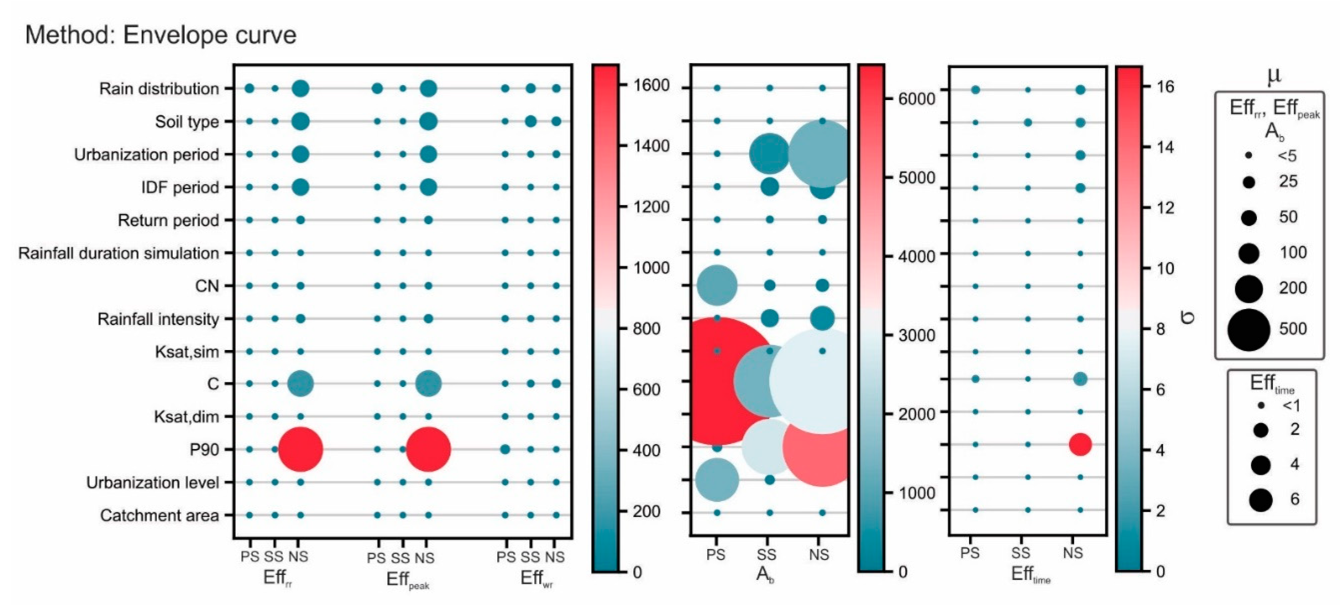
Figure 9, Figure 10, Figure 11 and Figure 12 show the result of the sensitivity analysis one-at-time, for the methods Bioretention manual, BIRENICE, envelope curve and WSUD manual, respectively. In general, the methods presented greater sensitivity to the same parameters, with the main difference occurring in the magnitude of the sensitivity, both in the mean and in the standard deviation. For Effrr and Effpeak, the parameters with the highest sensitivity are the C and daily precipitation with 90% probability (P90).
The C represents the catchment imperviousness level, which is related to the level of urbanization and, consequently, to the urbanization period. With the exception of BIRENICE, a sensitivity to the urbanization period for all methods was observed, with less important effects in the Bioretention manual for the NS. In all cases, C did not show high σ values, which indicates few higher-order effects. P90 was the parameter with the greatest sensitivity, with higher values for NS. It also presented the highest σ values for all methods (around 1600), indicating strong higher-order effects that may be explained by its interaction with other parameters, such as the future climate period and rainfall intensity.
For the Effwr of water reuse, in general, there is little sensitivity to the parameters since it will be more influenced by the infiltration rate and size of the underdrain (further discussion in Section 3.4). Efftime is also not very sensitive to parameters in general (as previously discussed).
The main differences between the design methods’ sensitivity can be observed in the sized area. For the Bioretention manual and BIRENICE methods, the sized areas are more sensitive to C (μ > 200) and to the urbanization period (μ > 50). These two parameters are related, leading to high σ values for C in both methods. For the envelope curve and WSUD manual methods, the greatest sensitivity is observed to C (μ > 1000), followed by P90 (μ > 500), and subsequently, the urbanization period (μ > 200) and urbanization level (μ > 200, for property scale). Higher-order effects are also more significant for C and P90.
The most sensitive parameters are related to the drivers of urbanization and climate change, such as total rainfall volume and runoff coefficient. Both parameters are directly associated with the total runoff volume generated and reaching the bioretention structure, i.e., the design is much more influenced by the total volume of runoff generated than how it occurs over time.

3.4. Impacts of the Changes in the Catchment Hydrological Behavior and in Bioretention Performance

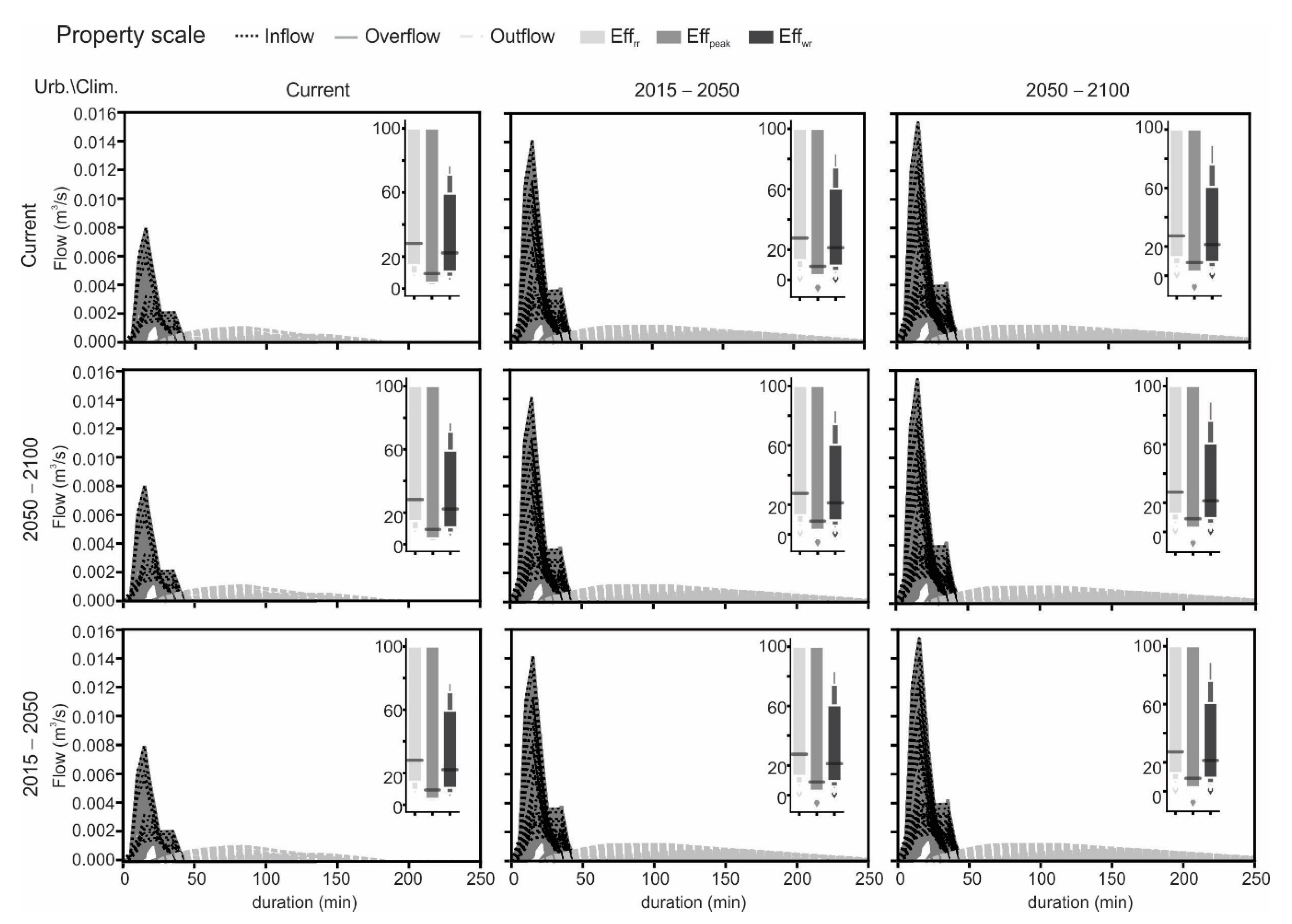
Figure 13, Figure 14 and Figure 15 show the simulated hydrographs for the different future scenarios and the combination of drivers of change for the three application sites evaluated. The hydrographs of all combinations of parameters and input variables are presented, generating a range of variability, as proposed by [44]. In the PS scale (Figure 13), there is no difference in hydrographs for the urbanization periods, as it is a consolidated area (no variation in land use). However, climate change may even double the inflow peak (when considering larger RPs).
When comparing to PS, for SS and NS (Figure 13 and Figure 14), urbanization has a greater influence in the hydrographs when analyzing its effect alone. For SS, the inflow can increase by 1.5×, while in NS, this value increases by up to 3×, for more advanced future scenarios. For these application scales, climate change also has a great influence, increasing inflow up to 4×. Refs. [61,62] also observed significant effects of climate change on the catchment hydrology, requiring a more careful design that is able to consider this driver of change. Ref. [63] evaluated the performance of bioretention structures under future climate change scenarios in North Carolina and noticed the need for increased storage capacity to maintain efficiency, which in this study it was incorporated through modular design. However, studies by [14,15,16] jointly evaluated the effects of urbanization and climate change and obtained urbanization as a more important factor, which, at first, may seem contradictory to this study.
However, the analysis of future scenarios in this study presents a zone of variability, considering different factors, including RP (which varies from 5 to 50 years). The MIROC5 model shows a great increase in extreme events in the city of São Carlos, which can also be seen from the analysis of the new IDFs built for the city, in which the same event with an RP in the current scenario of 50 years, reduced to 8.8 and 4.7 years for the future periods of 2015–2050 and 2050–2100, respectively. Therefore, the importance of climate change is much more pronounced for greater RP.
The external limit of the variability range represents the most extreme events (which tend to become even more extreme). The internal limit is related to more recurring RPs (5 to 10 years), which are the most frequently used in the design of adaptive urban drainage systems. The studies by [14,15,16] used rainfall events with greater recurrence (daily rainfall over a period of 30 years), which are comparable with the hydrograph internal limits. Thus, there is no disagreement in the results when analyzing the hydrograph simulated for more recurrent events (lower RP) in this study.
Regarding the efficiencies, for SS and NS, when the bioretention is designed only for future climate change, there is a drop in the upper limit of the efficiencies range. This probably happens because the design is more sensitive to the factors related to the urbanization level than the climate periods. When considering only the latter, it results in smaller-sized areas, which leads to less performance. In PS, as there are no changes in the runoff coefficients (C and CN), the drop of the upper limit in efficiency does not occur.
The different design methods resulted in considerable differences in the sized areas, which probably is the most important factor for the large variability range presented in the hydrographs. There are 100% Effrr even for the most advanced scenarios in the future, which happened predominantly for the design with the envelope curve method (which tends to over-design the areas). When regarding the sized areas at NS for the envelope curve method, there was a variation 6.1 to 35.6% of the impervious catchment area, depending on the future scenarios evaluated. The implementation of bioretention with these great sizes may not be viable due to both availability of land and costs of implementation and maintenance. Therefore, it is up to the decision-maker to balance between the required efficiencies and the available resources to decide which alternative is the best. The design methods Bioretention manual and BIRENICE are the ones that result in smaller sized areas (varying from 0.3 to 1.8% and 0.1 to 3.4% of the impervious catchment area, respectively), however, they are the ones with the worst Effrr and Effpeak. The method WSUD manual has good efficiency values and has a range of sized areas from 1.5 to 25.4% of the impervious catchment area.
Many manuals recommend bioretention surface areas of around 1 to 5% of the impervious catchment area [26,27,28]. On the other hand, ref. [64] determined that for rain gardens, the optimal exfiltration and groundwater recharge occurs in rates between the structure area and the directly connected impermeable area from 10 to 20%. However, from the results obtained, it is possible to see that this metric does not take into account future urbanization and climate scenarios and may lead to areas that are smaller than necessary for good performances.
Regarding the outflow (the volume recovered by the underdrain to be reused during dry periods), a softer release of the retained volume over time is observed, with smaller peaks and with longer duration. Regarding the performance of water recovery, there is a reduction in Effwr for larger scales of application and future scenarios (i.e., grater runoff generation). However, it does not indicate a reduction in the volume of water recovered but rather in the ratio between recovered volume and inflow volume.
For PS, in the current urbanization scenario and for soil type D, there is a volume of 1.5 m3 of recovered water during the first 250 min after the begging of the event. This volume increases to 82 m3 when analyzing the same conditions for SS, which represents a significant increase due to the bigger catchment area. However, for NS (twice the SS area), the recovered volume remains constant at 82 m3 for the first 250 min. Assessing the different future scenarios for both SS and NS, it is possible to notice that the recovered volumes always remain within a range of 82 to 85 m3, i.e., for higher areas, there is a moment when the recovered volume becomes practically constant. This volume is controlled mainly by the infiltration capacity of the filtering media and secondly by the underdrain capacity, which does not depend on factors related to the catchment area. Therefore, there were no major changes in recovered volume once the maximum capacity was reached.
For future studies, it is recommended to evaluate the change in the size of the underdrain pipe in order to increase the efficiency of water recovery (since Effwr was not very sensitive to the filtering media hydraulic conductivity). Although Effwr has not increased for the larger application sites, the volume of recovered water can contribute to the resilience of communities to water scarcity during drought periods if these systems are integrated with stormwater harvesting techniques. Thus, thinking about the means to increase and maintain Effwr for larger areas and future scenarios, it can further contribute even more to the resilience of communities to drought.

4. Conclusions

Given the intensification of impervious areas and climate change, floods and urban river contamination are expected to increase in the coming years. Adaptive measures of urban drainage such as LID practices can contribute to mitigating the effects of drivers of change in future scenarios, reducing the risk to the population. For that purpose, it is necessary to consider the future changes during the sizing and design stage of LID practices.
In this study, we applied the modular design as a procedure to incorporate the drivers of change in the sizing of bioretention systems in different application scales (PS, SS and NS), evaluating how the adoption of different climate and urbanization-related parameters can influence the system performance. As the main conclusions regarding the sizing method and bioretention performance, it was determined that:
  • Changes in climate patterns can be estimated by using Global Circulation Models or Regional Climate Models on the application site. Even with bias correction, these models still have inherent uncertainty which affects bioretention sizing and design. Therefore, ranges of variability should be considered during the calculations. The final choice of which value to adopt within the variability range is based on restrictive design criteria.
  • The bioretention surface area has a positive correlation with the efficiencies of runoff retention (r = 0.48) and peak flow attenuation (r = 0.51).
  • When evaluating all the combinations between sizing methods, parameters, and input variables, it was possible to observe that the sizing method and the structure aging (represented by the different values in hydraulic conductivity) are the parameters that most affect the final performance of bioretention systems.
  • The climate-related variable that most affected the bioretention efficiency was RP.
  • The urbanization-related parameters that most affected the bioretention efficiency were the soil type and the runoff coefficient.
  • From the sensitivity analysis of the sizing methods, the parameters C and P90 were identified as the most sensitive, with P90 presenting more high-order effects.
Once the bioretention systems were sized with modular design for all the application sites and future periods, we evaluated the hydrological performance of the catchment areas and the systems’ response. From this analysis, we could observe that climate change and urbanization increase have a synergic effect on runoff generation, increasing peak inflows up to 2×, 2.5× and 4× for PS, SS and NS, respectively, for 2050–2100 period. Despite this increase, the modular design of the bioretention system helped to maintain runoff retention and peak flow attenuation efficiencies along time (with medians around 30 and 5%, for runoff retention and peak flow attenuation, respectively, for all future scenarios).

Supplementary Materials

The following supporting information can be downloaded at https://www.mdpi.com/article/10.3390/su14116799/s1, Figure S1: Pictures of the flood disaster and economic losses occurred on 14 Jan 2020 in Sao Carlos, SP, Brazil (unknown source, wide circulation images on the internet), Figure S2: The difference between the observed and modelled monthly rainfall average data with and without bias correction for climate models used. For bias correction, power transformation (PT) and mapping distribution (MD) methods were used, Figure S3: Projected future IDF curves for the period 2015–2050 for the city of Sao Carlos, SP, Brazil, and return periods of (a) 5 years, (b) 25 years, (c) 50 years and (d) 100 years. For bias correction, power transformation (PT) and mapping distribution (MD) methods were used, Figure S4: Projected future IDF curves for the period 2050–2100 for the city of Sao Carlos, SP, Brazil, and return periods of (a) 5 years, (b) 25 years, (c) 50 years and (d) 100 years. For bias correction, power transformation (PT) and mapping distribution (MD) methods were used. Table S1: The results obtained for the statistical adherence test for the Gumbel-Weibull distribution model for all combinations of RCM and bias correction, Table S2: Disaggregation factors for sub-daily rainfall data for São Carlos, SP, Table S3: Variables of the model, Table S4: Parameters of the model, Table S5: Characteristics of the laboratory events used to calibrate and validate the water flow model.

Author Contributions

Conceptualization, M.B.d.M. and E.M.M.; methodology, M.B.d.M., M.N.G.J. and V.J.; formal analysis, M.B.d.M. and T.R.P.d.O.; investigation, M.B.d.M. and M.N.G.J.; resources, M.B.d.M., M.N.G.J. and V.J.; data curation, M.B.d.M.; writing—original draft preparation, M.B.d.M.; writing—review and editing, M.N.G.J., T.R.P.d.O. and E.M.M.; visualization, M.B.d.M.; supervision, E.M.M.; project administration, E.M.M.; funding acquisition, E.M.M. All authors have read and agreed to the published version of the manuscript.

Funding

This study was supported by FAPESP grant n. 2014/50848-9 INCT-II (Climate Change, Water Security), CNPq grant n. PQ 312056/2016-8 (EESC-USP/CEMADEN/MCTIC), and FAPESP grant n. 2017/15614-5 “Decentralized Urban Runoff Recycling Facility addressing the security of the Water-Energy-Food Nexus”.

Institutional Review Board Statement

Not applicable.

Informed Consent Statement

Not applicable.

Data Availability Statement

Not applicable.

Acknowledgments

The authors would like to acknowledge the Academic Excellence Program (PROEX)/Post-graduation program of Hydraulic Engineering and Sanitation (PPGSHS) of the Sao Carlos School of Engineering (EESC), University of Sao Paulo (USP).

Conflicts of Interest

The authors declare no conflict of interest.

References

  1. Leopold, L.B. Hydrology for Urban Land Planning: A Guidebook on the Hydrological Effects of Urban Land Use; U.S. Geological Survey: Washington, DC, USA, 1968; Volume 554. [Google Scholar]
  2. Konrad, C.P.; Booth, D.B. Hydrologic changes in urban streams and their Ecological significance. Am. Fish. Soc. Symp. 2005, 47, 157–177. [Google Scholar]
  3. Wong, T.H.F.; Eadie, M.L. Water sensitive urban design—A paradigm shift in urban design. In Proceedings of the Xth World Water Congress, Melbourne, Australia, 12–16 March 2000; Available online: http://gabeira.locaweb.com.br/cidadesustentavel/biblioteca/%7B30788FE6-98A8-44E5-861E-996D286A78B3%7D_Wong1.pdf (accessed on 10 October 2020).
  4. Santos, R.F. Vulnerabilidade Ambiental: Desastres Naturais ou Fenômenos Induzidos? [Environmental Vulnerability: Natural Disasters or Induced Phenomena?]; MMA: Brasilia, Brazil, 2007. (In Portuguese) [Google Scholar]
  5. Young, C.E.F.; Aguiar, C.; Souza, E. Valorando Tempestades: Custo Econômico dos Eventos Climáticos Extremos no Brasil nos Anos de 2002–2012 [Assessing Storms: Economic Cost of Extreme Weather Events in Brazil in the Years 2002–2012], 1st ed.; Observatório do Clima: São Paulo, Brazil. (In Portuguese)
  6. Debortoli, N.S.; Camarinha, P.I.M.; Marengo, J.A.; Rodrigues, R.R. An index of Brazil’s vulnerability to expected increases in natural flash flooding and landslide disasters in context of climate change. Nat. Hazards 2017, 86, 557–582. [Google Scholar] [CrossRef]
  7. Marengo, J.A.; Schaeffer, R.; Zee, D.; Pinto, H.S. Mudanças Climáticas e Eventos Extremos no Brasil [Climate Change and Extreme Events in Brazil]. 2010. Available online: http://www.fbds.org.br/cop15/FBDS_MudancasClimaticas.pdf (accessed on 10 October 2010). (In Portuguese).
  8. IPCC. Climate Change 2021—The Physical Science Basis. Working Group I Contribution to the Sixth Assessment Report of the Intergovernmental Panel of Climate Change; IPCC: Geneva, Switzerland, 2021. [Google Scholar]
  9. Houston, D.; Werritty, A.; Bassett, D. Pluvial (Rain-Related) Flooding in Urban Areas: The Invisible Hazard. Joseph Rowntree Foundation. Available online: http://www.jrf.org.uk/sites/files/jrf/urban-flood-risk-full.pdf (accessed on 10 March 2019).
  10. C40. Climate Action in Megacities: C40 Cities Baseline and Opportunities. Volume 2.0. February 2014. Available online: http://issuu.com/c40cities/docs/c40_climate_action_in_megacities/149?e=10643095/6541335 (accessed on 12 April 2018).
  11. Fletcher, T.D.; Shuster, W.; Hunt, W.F.; Ashley, R.; Butler, D.; Arthur, S.; Viklander, M. SUDS, LID, BMPs, WSUD and more–The evolution and application of terminology surrounding urban drainage. Urban Water J. 2015, 12, 525–542. [Google Scholar] [CrossRef]
  12. Macedo, M.B.; Gomes Junior, M.N.; Oliveira, T.R.P.; HGiacomoni, M.; Imani, M.; Zhang, K.; Ambrogi Ferreira do Lago, C.; Mendiondo, E.M. Low Impact Development practices in the context of United Nations Sustainable Development Goals: A new concept, lessons learned and challenges. Crit. Rev. Environ. Sci. Technol. 2021, 52, 2538–2581. [Google Scholar] [CrossRef]
  13. Laurenson, G.; Laurenson, S.; Bolan, N.; Beecham, S.; Clark, I. The role of bioretention systems in the treatment of stormwater. Adv. Agron. 2013, 120, 223–274. [Google Scholar]
  14. Liu, Y.; Engel, B.A.; Collingsworth, P.D.; Pijanowski, B.C. Optimal implementation of green infrastructure practices to minimize influences of land use change and climate change on hydrology and water quality: Case study in Spy Run Creek watershed, Indiana. Sci. Total Environ. 2017, 601, 1400–1411. [Google Scholar] [CrossRef]
  15. Liu, Y.; Theller, L.O.; Pijanowski, B.C.; Engel, B.A. Optimal selection and placement of green infrastructure to reduce impacts of land use change and climate change on hydrology and water quality: An application to the Trail Creek Watershed, Indiana. Sci. Total Environ. 2016, 553, 149–163. [Google Scholar] [CrossRef] [PubMed]
  16. Pyke, C.; Warren, M.P.; Johnson, T.; LaGro, J., Jr.; Scharfenberg, J.; Groth, P.; Freed, R.; Schroeer, W.; Main, E. Assessment of low impact development for managing stormwater with changing precipitation due to climate change. Landsc. Urban Plan. 2011, 103, 166–173. [Google Scholar] [CrossRef]
  17. Semadeni-Davies, A.; Hernebring, C.; Svensson, G.; Gustafsson, L.G. The impacts of climate change and urbanisation on drainage in Helsingborg, Sweden: Suburban stormwater. J. Hydrol. 2008, 350, 114–125. [Google Scholar] [CrossRef]
  18. Willems, P. Revision of urban drainage design rules after assessment of climate change impacts on precipitation extremes at Uccle, Belgium. J. Hydrol. 2013, 496, 166–177. [Google Scholar] [CrossRef]
  19. Madsen, H.; Lawrence, D.; Lang, M.; Martinkova, M.; Kjeldsen, T.R. Review of trend analysis and climate change projections of extreme precipitation and floods in Europe. J. Hydrol. 2014, 519, 3634–3650. [Google Scholar] [CrossRef] [Green Version]
  20. DeGaetano, A.T.; Castellano, C.M. Future projections of extreme precipitation intensity-duration-frequency curves for climate adaptation planning in New York State. Clim. Serv. 2017, 5, 23–35. [Google Scholar] [CrossRef]
  21. INMET—Instituto Nacional de Meteorologia. Normais Climatológicas do Brasil [Brazilian Climatological Norms]. 2016. Available online: https://portal.inmet.gov.br/normais (accessed on 10 October 2021). (In Portuguese)
  22. Fava, M.C.; Abe, N.; Restrepo-Estrada, C.; Kimura, B.Y.; Mendiondo, E.M. Flood modelling using synthesised citizen science urban streamflow observations. J. Flood Risk Manag. 2018, 12, e12498. [Google Scholar] [CrossRef] [Green Version]
  23. Abreu, F.G. Quantificação dos Prejuízos Econômicos à Atividade Comercial Derivados de Inundações Urbanas [Quantification of Economic Losses to Commercial Activity Derived from Urban Flooding]. Ph.D. Thesis, Escola de Engenharia de São Carlos, Universidade de São Paulo, São Carlos, Brazil, 2019. (In Portuguese). [Google Scholar]
  24. PMSC—Prefeitura Municipal de São Carlos. Plano Diretor do Município de São Carlos. Lei no 18.053, de 19 de Dezembro de 2016 [Master Plan of the Municipality of São Carlos. Law 18.053 of 19 December 2016]. 2016. Available online: https://leismunicipais.com.br/plano-diretor-sao-carlos-sp (accessed on 11 September 2019). (In Portuguese)
  25. Marsalek, J.; Schreier, H. Innovation in Stormwater Management in Canada: The Way Forward, Water Quality Resources. Water Qual. Res. J. 2009, 44, v–x. [Google Scholar] [CrossRef] [Green Version]
  26. Waterways, M.B. Water Sensitive urban Design: Technical Design Guidelines for South East Queensland. Moreton Bay Waterways and Catchment Partnership. 2005. Available online: https://www.brisbane.qld.gov.au/planning-and-building/planning-guidelines-and-tools/brisbane-city-plan-2014/superseded-brisbane-city-plan-2000/superseded-subdivision-and-development-guidelines/water-sensitive-urban-design/engineering-guidelines-superseded (accessed on 28 August 2020).
  27. Bioretention Manual; Environmental Services Division, Department of Environmental Resources: Prince George’s County, MD, USA. 2007. Available online: https://www.ct.gov/deep/lib/deep/p2/raingardens/bioretention_manual_2009_version.pdf (accessed on 25 September 2018).
  28. COUNCIL, Gold Coast City. Water Sensitive Urban Design Guidelines; Gold Coast City Council: Queensland, Australia, 2007. [Google Scholar]
  29. McAuley, A. Technical Design Guidelines; Northern Territory Department of Planning and Infrastructure: Darwin, Australia, 2009. [Google Scholar]
  30. Urbonas, B.; Stahre, P. Stormwater: Best Management Practices and Detention for Water Quality, Drainage, and CSO Management; Prentice Hall: Hoboken, NJ, USA, 1993. [Google Scholar]
  31. Silveira, A.L.L.; Goldenfum, J.A. Metodologia Generalizada para Pré-Dimensionamento de Dispositivos de Controle Pluvial na Fonte [Generalized Methodology for Pre-Dimensioning of Rainwater Control Devices at Source]. RBRH 2007, 12, 57–168. (In Portuguese) [Google Scholar] [CrossRef]
  32. Chow, V.T.; Maidment, D.R.; Larry, W. Mays. In Applied Hydrology, International ed.; MacGraw-Hill Inc.: New York, NY, USA, 1988; p. 149. [Google Scholar]
  33. Rosa, A. Bioretention for Diffuse Pollution Control in SUDS Using Experimental-Adaptive Approaches of Ecohydrology. Ph.D. Thesis, Escola de Engenharia de São Carlos, Universidade de São Paulo, São Carlos, Brazil, 2016. [Google Scholar]
  34. Hunt, W.; Lord, B.; Loh, B.; Sia, A. Plant Selection for Bioretention Systems and Stormwater Treatment Practices. In Springer Briefs in Water Science and Technology; Springer: New York, NY, USA, 2015. [Google Scholar]
  35. Canholi, A.P. Drenagem Urbana e Controle de Enchentes [Urban Drainage and Floods Control], 2nd ed.; Oficina de Textos: São Paulo, Brazil, 2014. (In Poruguese) [Google Scholar]
  36. Madsen, H.; Arnbjerg-Nielsen, K.; Mikkelsen, P.S. Update of regional intensity–duration–frequency curves in Denmark: Tendency towards increased storm intensities. Atmos. Res. 2009, 92, 343–349. [Google Scholar] [CrossRef]
  37. Soro, G.E.; Goula-Bi, T.A.; Kouassi, F.W.; Srohourou, B. Update of intensity duration frequency curves for precipitation of short durations in tropical area of West Africa (Côte D’ivoire). J. Appl. Sci. 2010, 10, 704–715. [Google Scholar] [CrossRef]
  38. Mailhot, A.; Duchesne, S. Design criteria of urban drainage infrastructures under climate change. J. Water Resour. Plan. Manag. 2009, 136, 201–208. [Google Scholar] [CrossRef]
  39. Wang, D.; Hagen, S.C.; Alizad, K. Climate change impact and uncertainty analysis of extreme rainfall events in the Apalachicola River basin, Florida. J. Hydrol. 2013, 480, 125–135. [Google Scholar] [CrossRef]
  40. De Paola, F.; Galdiero, E.; Giugni, M.; Pugliese, F. Sustainable development of storm-water systems in African cities considering climate change. Procedia Eng. 2015, 119, 1181–1191. [Google Scholar] [CrossRef] [Green Version]
  41. Chou, S.C.; Lyra, A.; Mourão, C.; Dereczynski, C.; Pilotto, I.; Gomes, J.; Bustamante, J.; Tavares, P.; Silva, A.; Rodrigues, D.; et al. Assessment of climate change over South America under RCP 4.5 and 8.5 downscaling scenarios. Am. J. Clim. Chang. 2014, 3, 512–525. [Google Scholar] [CrossRef] [Green Version]
  42. Lyra, A.; Tavares, P.; Chou, S.C.; Sueiro, G.; Dereczynski, C.; Sondermann, M.; Silva, A.; Marengo, J.; Giarolla, A. Climate change projections over three metropolitan regions in Southeast Brazil using the non-hydrostatic Eta regional climate model at 5-km resolution. Theor. Appl. Climatol. 2018, 132, 663–682. [Google Scholar] [CrossRef]
  43. Teutschbein, C.; Seibert, J. Bias correction of regional climate model simulations for hydrological climate-change impact studies: Review and evaluation of different methods. J. Hydrol. 2012, 456, 12–29. [Google Scholar] [CrossRef]
  44. Willems, P.; Vrac, M. Statistical precipitation downscaling for small-scale hydrological impact investigations of climate change. J. Hydrol. 2011, 402, 193–205. [Google Scholar] [CrossRef]
  45. Pachauri, R.K.; Meyer, L.A. (Eds.) IPCC, 2014: Climate Change 2014: Synthesis Report. Contribution of Working Groups I, II and III to the Fifth Assessment Report of the Intergovernmental Panel on Climate Change; IPCC: Geneva, Switzerland, 2014; p. 151. [Google Scholar]
  46. Levine, D.M.; Berenson, M.L.; Stephan, D. Estatística—Teoria e Aplicações [Statistics—Theory and Applications], 5th ed.; LTC: Rio de Janeiro, Brazil, 2008. (In Portuguese) [Google Scholar]
  47. Barbassa, A.P. Simulação do Efeito da Urbanização Sobre a Drenagem Pluvial da Cidade de São Carlos—SP [Simulation of the Effect of Urbanization on the Storm Drainage of the City of São Carlos—SP]. Doctoral thesis, Escola de Engenharia de São Carlos, Universidade de São Paulo, São Carlos, Brazil, 1991. (In Portuguese). [Google Scholar]
  48. Koutsoyiannis, D.; Kozonis, D.; Manetas, A. A mathematical framework for studying rainfall intensity-duration-frequency relationships. J. Hydrol. 1998, 206, 118–135. [Google Scholar] [CrossRef]
  49. Lehmann, E.A.; Phatak, A.; Stephenson, A.; Lau, R. Spatial modelling framework for the characterisation of rainfall extremes at different durations and under climate change. Environmetrics 2016, 27, 239–251. [Google Scholar] [CrossRef] [Green Version]
  50. Muller, A.; Bacro, J.N.; Lang, M. Bayesian comparison of different rainfall depth–duration–frequency relationships. Stoch. Environ. Res. Risk Assess. 2008, 22, 33–46. [Google Scholar] [CrossRef] [Green Version]
  51. Gomes Junior, M.N. Aspectos Hidrológicos-Hidráulicos e Avaliação da Eficiência de Biorretenções: Modelos, Princípios e Critérios de Projeto de Técnicas Compensatórias de 3ª Geração [Hydrological-Hydraulic Aspects and Evaluation of Bioretention Efficiency: Models, Principles and Design Criteria for 3rd Generation LID]. Master’s Thesis, Escola de Engenharia de São Carlos, Universidade de São Paulo, São Carlos, Brazil, 2019. (In Portuguese). [Google Scholar]
  52. São Paulo (cidade). Secretaria Municipal de Desenvolvimento Urbano. In Manual de Drenagem e Manejo de Águas Pluviais: Aspectos Tecnológicos; diretrizes para projetos; SMDU: São Paulo, Brazil, 2012. [Google Scholar]
  53. Tucci, C.E. Hidrologia: Ciência e Aplicação, 2nd ed.; Universidade/UFRGS/ABRH: Porto Alegre, Brazil, 2001. [Google Scholar]
  54. Randelovic, A.; Zhang, K.; Jacimovic, N.; McCarthy, D.; Deletic, A. Stormwater biofilter treatment model (MPiRe) for selected micro-pollutants. Water Res. 2016, 89, 180–191. [Google Scholar] [CrossRef]
  55. Shen, P.; Deletic, A.; Urich, C.; Chandrasena, G.I.; McCarthy, D.T. Stormwater biofilter treatment model for faecal microorganisms. Sci. Total Environ. 2018, 630, 992–1002. [Google Scholar] [CrossRef]
  56. Macedo, M.B.; Oliveira, T.R.P.; Oliveira, T.H.; Gomes Junior, M.N.; Brasil, J.A.T.; do Lago, C.A.F.; Mendiondo, E.M. Evaluating low impact development practices potentials for increasing flood resilience and stormwater reuse through lab-controlled bioretention systems. Water Sci. Technol. 2021, 84, 1103–1124. [Google Scholar] [CrossRef]
  57. Song, X.; Zhang, J.; Zhan, C.; Xuan, Y.; Ye, M.; Xu, C. Global sensitivity analysis in hydrological modeling: Review of concepts, methods, theoretical framework, and applications. J. Hydrol. 2015, 523, 739–757. [Google Scholar] [CrossRef] [Green Version]
  58. Morris, M.D. Factorial sampling plans for preliminary computational experiments. Technometrics 1991, 33, 161–174. [Google Scholar] [CrossRef]
  59. Campolongo, F.; Cariboni, J.; Saltelli, A. An effective screening design for sensitivity analysis of large models. Environ. Model. Softw. 2007, 22, 1509–1518. [Google Scholar] [CrossRef]
  60. Hofmann, H.; Wickham, H.; Kafadar, K. Letter-value plots: Boxplots for large data. J. Comput. Graph. Stat. 2017, 26, 469–477. [Google Scholar] [CrossRef]
  61. Dudula, J.; Randhir, T.O. Modelling the influence of climate change on watershed systems: Adaptation through targeted practices. J. Hydrol. 2016, 541, 703–713. [Google Scholar] [CrossRef] [Green Version]
  62. Ghazal, R.; Ardeshir, A.; Rad, I.Z. Climate change and stormwater management strategies in Tehran. Procedia Eng. 2014, 89, 780–787. [Google Scholar] [CrossRef] [Green Version]
  63. Hathaway, J.M.; Brown, R.A.; Fu, J.S.; Hunt, W.F. Bioretention function under climate change scenarios in North Carolina, USA. J. Hydrol. 2014, 519, 503–511. [Google Scholar] [CrossRef]
  64. Dussaillant, A.R.; Wu, C.H.; Potter, K.W. Richards equation model of a rain garden. J. Hydrol. Eng. 2004, 9, 219–225. [Google Scholar] [CrossRef]
Figure 1. Methodology flowchart. Highlighted: the location, data, parameters and methods chosen for this study.
Sustainability 14 06799 g001
Figure 2. Geographic location of the study area: Mineirinho river catchment and implementation sites of LID practices at property scale (a), street scale (b) and neighborhood scale (c). Area 1 is the campus of the University of São Paulo at São Carlos, where the bioretention systems for the property scale and street scale are designed. Area 2 is a new housing state with forecast expansion, where the bioretention system for the neighborhood-scale is designed.
Sustainability 14 06799 g002
Figure 3. The general design of the bioretention system proposed for all catchment areas. The dimensions are kept constant for all the scenarios, with variations in parameters and surface areas.
Sustainability 14 06799 g003
Figure 4. Land use for LID practices at street and neighborhood scale for the current and future scenarios, according to São Carlos master plan.
Sustainability 14 06799 g004
Figure 5. Pearson correlation coefficients between parameters and input variables representing the drivers of change, sized areas, and evaluation functions for the performance of the bioretention.
Sustainability 14 06799 g005
Figure 6. Letter-value plots for runoff retention, peak flow attenuation and water reuse efficiency, different parameters and input variables.
Sustainability 14 06799 g006
Figure 7. Letter-value plots for time delay efficiency, different parameters and input variables.
Sustainability 14 06799 g007
Figure 8. Letter-value plots for sized areas, different parameters and input variables.
Sustainability 14 06799 g008
Figure 9. Sensitivity analysis of the bioretention manual method.
Sustainability 14 06799 g009
Figure 10. Sensitivity analysis of the BIRENICE method.
Sustainability 14 06799 g010
Figure 11. Sensitivity analysis of the envelope curve method.
Sustainability 14 06799 g011
Figure 12. Sensitivity analysis of WSUD manual method.
Sustainability 14 06799 g012
Figure 13. Bioretention hydrographs and performance for future scenarios of climate and urbanization for property scale.
Sustainability 14 06799 g013
Figure 14. Bioretention hydrographs and performance for future scenarios of climate and urbanization for street scale.
Sustainability 14 06799 g014
Figure 15. Bioretention hydrographs and performance for future scenarios of climate and urbanization for neighborhood scale.
Sustainability 14 06799 g015
Table 2. Parameters adopted or calibrated for mathematical simulation and in design methods.
ParameterDescriptionValueUnitAcquisition
hpHeight of the ponding zone0.3mAdopted in design
HsmHeight of soil mix layer1.0mAdopted in design
HgHeight of gravel layer0.2mAdopted in design
nsmSoil mix porosity0.32-Adopted in design
ngGravel porosity0.4-Adopted in design
tbEmptying time24hAdopted in design
KsatHydraulic conductivity See Section 2.2.3mm/hAdopted in design
FSSafety factor2-Adopted in design
KcEvapotranspiration constant for plants1.38-Calibrated
KweirWeir coefficient1.3-Adopted in design
ExpweirWeir exponent2.5-Adopted in design
shHydroscopic soil moisture0.036-Calibrated
swWilting point moisture0.120-Calibrated
sfcField capacity0.435-Calibrated
ssPlant stress moisture0.482-Calibrated
hpipeHeight of underdrain pipe0.2mAdopted in design
dpipeUnderdrain pipe diameter32mmAdopted in design
CdDischarge coefficient for the pipe0.33-Calibrated
ΔtTime-step5minAdopted in simulation
Table 3. Runoff coefficient for current and future scenario according to established land use.
Street ScaleNeighborhood Scale
Current2015–20502050–2100Current2015–20502050–2100
(50% Urbanization)(80% Urbanization)(80% Urbanization)(100% Urbanization)
Aunderbrush (m2)15,97311,500351436,78911,8091104
Aroof (m2)573504613,032487729,85640,562
Asidewalk (m2)191019101910---
Astreet (m2)455045504550594059405940
Atotal (m2)23,00623,00623,00647,60647,60647,606
C0.40.60.80.40.70.9
CNA627289608697
CNB778292769197
CNC848894839398
CND889095879598
Index in CN represents the hydrological soil group.
Table 4. Numerical values of the parameters of the IDF curves updated with climate change patterns for the interval ranges analyzed.
CurrentMIROC5 4.5 PTMIROC5 4.5 MDMIROC5 8.5 PTMIROC5 8.5 MD
2015–2050
K819.67772.4764.56899.82890.51
m0.1380.3110.29560.21820.2176
t010.7712121212
n0.750.7640.7640.7640.764
2050–2100
K819.671007.77965.931036.491034.01
m0.1380.26450.21130.23560.2007
t010.7712121212
n0.750.7640.7640.7640.764
I = K   R P m ( t   +   t 0 ) n .
Table 5. Parameters and input values evaluated and their respective base values and interval ranges analyzed.
Parameter/Input VariableUnitBase ValuesRange
PSSSNS
Catchment area(m2)9423,00047,60094, 23,000, 47,600
Method Each methodBioretention manual, BIRENICE, Envelope curve, WSUD manual
Urbanization period CurrentCurrent, 2015–2050, 2050–2100
IDF period CurrentCurrent, 2015–2050, 2050–2100
IDF coefficients IDF current periodSee Table 5
Soil type AA, B, C, D
Urbanization level(%)100302222, 30, 50, 80, 100
Rain duration simulation(min)3030, 90
Return period(Years)55, 10, 25, 50
Ksat,sim (mm/h)195195, 468
Ksat,dim (mm/h)195195, 468
Rain intensity(mm/h)63.44Calculated according to IDF and rain duration
CN(-)CN current period soil ASee Table 4
C(-)0.90.40.40.4, 0.6, 0.7, 0.8, 0.9
Rain distribution Alternated blocksAlternated blocks, Huff 1st quartile, Rational
P90(mm)32.5Calculated according to daily rainfall in future climate projections
Publisher’s Note: MDPI stays neutral with regard to jurisdictional claims in published maps and institutional affiliations.