1. Introduction
Functional zoning and strategic planning are important and required conditions for the sustainable organization of territories. Analysis of literary sources shows that functional zoning in Kazakhstan has been worked out and tested mainly in the territories of the settlements in the frames of urban planning documents of territorial planning but in inter-settlement territories, such issues were almost not considered. At the same time, inter-settlement territories cover more than 92% of the territory of Kazakhstan [
1].
Functional zoning involves the analysis of nature use and includes component-oriented characteristics of the natural environment, and analysis of the social-economic and ecological condition of the territory. Types of environmental management are studied and mapped, and classification is created in terms of environmental impact [
2]. It is widely recognized that zoning planning has an impact to the structure and diversification of land use [
3].
Functional zoning is a tool that spatially determines those types of land use that are allowed for certain types of landscapes and will contribute to their balanced use [
4]. Functional zoning as one of the types of spatial planning is of great practical importance for the coordination and balanced sustainable development of territorial spaces [
5]. At the same time, the land use planning system should contribute to the landscapes balanced use and conservation, which is especially important for the regional development of territories [
6]. At the same time, territorial spaces can contain many different and often overlapping functions, and both synergistic and antagonistic relationships can exist between functions. In this regard, it is necessary to take into account all the functions in a particular landscape, determine their multifunctionality, if available and conduct comprehensive assessment of the potentials provided by the landscape [
7].
Assessment of landscapes ecosystem functions is a multicomponent task due to their complex structural and functional organization [
8]. Spatial information about landscape functions is insufficient, as only some landscape functions are directly related to observed landscape features (developed area and residential function, or forest and timber production). Spatial information about other landscape functions depends on additional intensive field observations or mapping activities [
9].
The world community has recognized that the Aral Sea crisis is one of the largest ecological and social-economic crises created by human in the 20th century because of the desire to obtain economic benefits, without taking into account the negative environmental consequences. The main reason for the development of this phenomenon is an erroneous strategy for the development of agriculture through the production of water-intensive crops, without taking into account the limited water resources of the region, nor the recharge capacity of the basin. [
10]. The consequences of the irrational use of natural resources were rapid decrease of Aral Sea level, followed by sea division into separate parts and formation of drying territories, development of dust storms with the transfer of salt-dust mixture for hundreds of kilometers, loss of biodiversity, and activation of desertification processes. However, the most important influences of the environmental crisis were social stress, economic losses and public health impacts. Based on these consequences, the Aral Sea region of Kazakhstan, including the study area, was declared an ecological disaster zone in 1992 [
11].
According to their position in the landscape and features of economic use, river deltas are especially vulnerable and are under the threat of destruction. This is mainly due to the ongoing draining, transformation, and pollution and overuse of their resources. Landscapes of wetlands in river deltas, due to their multifunctionality (environment forming, resource, water protection, recreational, reproduction of waterfowl, bird colonies, habitats of commercial wild animals, etc.) are of great biospheric importance. They are of particular value and uniqueness for the desert zone [
12]. Therefore, it is necessary to carry out zoning here, combining geographical and environmental aspects and allowing developing scientifically based recommendations for optimizing of existing land management systems and complex of measures to protect the environment in modern conditions.
The result of comprehensive analysis is a detailed description of the natural and economic conditions of each specific area, including significant development factors, a list of real and potential problems, key conflicts in resource consumption, and a list of areas most sensitive to anthropogenic impacts [
13]. Thus, the functional zoning of the territory is a necessary condition for organization of the territory in order to preserve the habitat.
In accordance with the above, the purpose of the study was to develop functional zoning scheme for the territory of Syr Darya River delta using GIS. The relevance of the study is related to obtaining new spatial data and developing recommendations for the sustainable use of land within the delta of Syr Darya River—the most developed by the population zone of ecological disaster in Kazakh part of the Aral Sea region.
2. Materials and Methods
2.1. Study Area
Since ancient times, river deltas have been of fundamental importance for the appearance and development of civilizations [
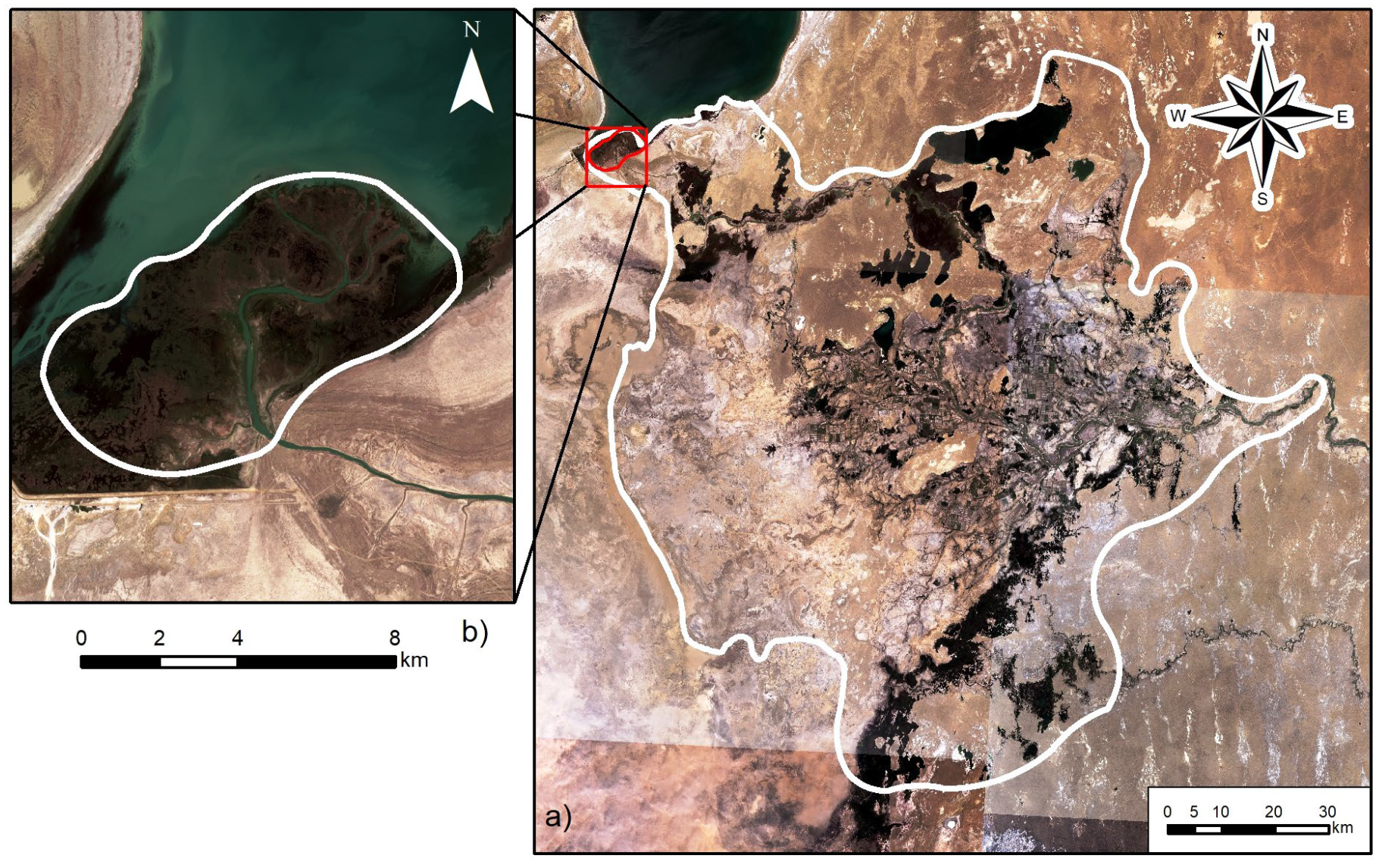
14]. One such center of civilization development and the oldest center of agriculture is the Aral Sea region, with the Syr Darya River delta located in the limits of Kazakhstan (
Figure 1). Since river deltas are located in the zone of interaction between land and sea, they are a source of various natural resources and serve as an important link for transport communications and trade development—since ancient times, they have been the most valuable habitat and recreation for people, i.e., territory of multifunctional use. The natural specific of the Aral Sea region within the valley and different ages deltas of Syr Darya river contributed to the development of ancient agriculture here, starting in the Bronze Age [
15].
At the present time, river valleys and deltas maintain their importance in the settlement of the population as territories provided with water, fertile lands with richer vegetation and wildlife comparatively to the surrounding territories. This is most typical for the rivers of arid regions with unfavorable climates, which include the Valley of Syr Darya River within the Kyzylorda region of Kazakhstan. Here, in the considered geosystem [
16], natural factors (climate, geological, and geomorphological conditions, natural waters, soil and vegetation cover and wildlife) are subject to anthropogenic impact in the form of social-economic (residential, agricultural, industrial, transport, and recreational) and cultural–historical factors. As a result of the interaction, a complex natural–anthropogenic system was formed, characterized by varying degrees of transformation and ecological condition, complex combination of different, often mutually exclusive interests of nature users. In this regard, in the conditions of modern market relations and conflicts of traditional nature users, it is required to develop the basis for sustainable management in the form of functional zoning, focused on improving the life of population, rational development of resources, and improving the ecological condition through the elimination of conflicts and coordination of the activities of nature users, which was the goal of the research.
For the functional zoning of the territory, the area of the modern delta of Syr Darya river was chosen due to its high diversity of landscape functions. The total area of Syr Darya river delta is 11,656 km2 or 5.1% of the territory of the Kyzylorda region. The coordinates of the geographical boundaries of the study area are within 45°5′56″–46°15′40″ northern latitude. and 60°53′23″–62°26′25″ eastern longitude. Administratively, the delta is located within the Aral (67.7%) and Kazaly (32.3%) districts of the Kyzylorda region. As of 1 January 2022, there are 47 settlements in the study area, which are part of 29 rural districts, with a population of 90,255 people.
Until the 1960s, the delta of Syr Darya River, which received a lot of water and sediment. This azonal object was characterized by high biodiversity and biological productivity. As a result of anthropogenically caused reduction in the inflow of water into the river and subsequent lowering of Aral Sea level, Syr Darya river delta and its hydrographic net and landscapes experienced serious degradation [
17]. In many ways, the delta has lost its specific “deltaic” natural complex [
18].
Over the past 20 years, due to the implementation of major environmental projects at the national and international levels, the ecological condition of the environment in Aral region has been improving [
19,
20]. At the same time, the following problems caused by anthropogenic interference remain relevant: degradation of the land and natural vegetation, dust storms, reduction of resources and deterioration of water quality, salinization of irrigated lands, and decrease in biological diversity.
As a result of anthropogenic regression of Aral Sea, a desert with the area of 21.4 thousand km
2 was formed in Kazakhstan part of Aral Sea region [
21]. In the lower reaches of Syr Darya river, adjacent to Aral Sea, of 2582 large and small lakes, there remain only 155. In the agricultural part of Syr Darya river delta, groundwater balance incoming items decreased, which led to increase in their mineralization from 1 to 10 g/L and in three times increased the land areas with groundwater mineralization up to 10–25 g/L [
22].
General Natural Characteristics of the Study Area
The modern delta of the Syr Darya river can be divided into two generations (
Figure 2). The main one is “Kazaly,” which was formed for a long time in conditionally natural conditions by the level of Aral Sea at 53 m. The second is “Northern Aral,” the main elements of which have been formed over the past 50 years and are associated with a rapid decrease of the sea level, the creation of system of protective dams and artificial basis level of erosion in the form of the Small Aral Sea as a result of the construction in 2005 of the Kokaral dam with a spillway structure.
The Northern Aral delta is a composite multi-branch type, the area of which reaches 36 km2. As for relief, it is a flat surface, slightly elevated above sea level, dissected by channels, and composed of loose fine-grained material due to the sedimentation of suspended sediments. Most of the Northern Aral delta is occupied by difficult to traverse swampy areas with overflow land, reedbeds and delta channels. In 2012, the Northern Aral delta and part of its delta front, due to the richness of biodiversity, were included in the Ramsar list of wetlands of Kazakhstan.
The length of the Kazaly delta from the mouth—the area of runoff dispersion (Basykara village) to the west—to the borders of the former Aral Sea is 80 km. A fan-shaped extension of the delta from north to south reaches 120 km. The Kazaly delta is alluvial delta strongly dissected by channels and delta lakes, formed under conditions of the predominance of fluvial processes. In the structure of Kazaly delta, there are estuarine, deltaic, delta-front (pre-estuarial coastal) sections, underwater slope and a shallow shelf. The estuarine part of the Syr Darya river has a clear structure with expansions (up to three km) and narrowings (up to one km) of the valley associated with the submeridional ridge relief type of the watershed surface. In the extensions, meandering and bifurcation of the river are observed. The channel width varies from 80 to 300 m. The depth of the river in low water is up to 4–6 m. The water is turbid and contains large amount of suspended particles. It is characterized by wide floodplain overgrown with reeds up to 1.5–2 m high above the low water level. In some areas, for example, near Basykara village, the channel was straightened with the formation of a straight section seven km long.
The river delta itself, due to the presence of fertile soils and high moisture content, served as the basis for the intensive development of irrigated agriculture. As a result of the development, the delta relief has been transformed by the net of irrigation canals, planning and fencing of the irrigation area, presence of engineering, and transport net and settlements. Here is clearly traced the alternation of near-channel banks and inter-channel depressions (dry former riverbed, active channels, lake kettles, and swamps), complicated by an irrigation net that regulates the natural process of moistening and land reclamation conditions of the Kazaly irrigation massif [
23]. Dewatering of the Aral Sea led to a complex of degradation processes in delta, to a decrease in the volume of river flow, decrease in groundwater level, and salinization of soils and formation of drift sands areas.
In the modern relief of the drained bottom, the former sea edge of Kazaly delta, areas of the delta front (pre-estuary seashore) and shallow shelf of the sea are visible. Under subaerial conditions, these territories have undergone some changes (salinization of soils, development of drift sands and dust storms).
The climatic conditions of the study area, according to meteorological stations of RSE “Kazhydromet” (Kazaly, Kaukei) are estimated to be continental and arid, with hot summers and moderately strong winters. The annual amount of total solar radiation reaches 7152 MJ/m
2 by clear skies and about 6058 MJ/m
2 by average cloudy conditions. The annual sum of hours with sunshine reaches 3000 h, i.e., in the average year the sun shines for 8.2 h a day. The average annual air temperature reaches 9.4 °C, the average July temperature is 27.0 °C, the average for January is −9 °C. The average annual amount of precipitation per year totals only 130 mm, which is unsufficient. On average, north–east winds prevail over the year, with an average annual wind speed of 2.0 m/s [
24]. The exception is dust storms, which carry dust–salt soil particles from the surface of the dried bottom.
The soil cover of the delta plain is represented mainly by meadow saline soil (22.6%), desert sands (15.1%) and gray–brown desert soils (12.1%). In the central part of the delta, insignificant distribution have hydromorphic and semi-hydromorphic soils of varying degrees of salinity (meadow–brown, meadow, meadow–marsh, and marsh), the formation of which is ensured by watered channels and drainage channels from irrigated lands. Saline soils of anthropogenic origin (secondary salinization) are widespread. The most drained areas of the delta are occupied by alkali soils, which form complexes of gray–brown desert soils of varying degrees of salinity [
25]. All soils of the surveyed area are characterized by the low content of humus, weak anti-erosion, and anti-deflation resistance, sharply expressed susceptibility to salinization and alkalinization, low availability of available for plants nitrogen and phosphorus compounds with sufficient potassium reserves, and predominance of alkaline reaction and high carbonate content.
The vegetation of the river delta is characterized by low species diversity and small projective cover and is represented by the main communities of deserts (dwarf semishrub and shrubs). The greatest impact to the delta vegetation was made by agriculture (change of natural vegetation by agrocenoses). At the same time, only the Kazaly irrigation area occupies 24% of the territory of the delta. Grazing also actively influences the natural vegetation. There is focal overgrazing around wintering areas, watering places, settlements and focal–linear overgrazing is along the routes of cattle passes. Vegetation degradation occurs under the technogenic impact of the engineering and transport net; it is also associated with regulation of river flow and cutting down of haloxylon. Vegetation of sandy deserts is especially strongly disturbed. Transformation of meadow and tugai (bottom-land forest) vegetation took place in the floodplains of the rivers.
In general, the spatial structure of the delta is dominated by accumulative landscapes of the alluvial plain with trees and shrub, russian thistle–halophyte–motley grass, motley grass-wormwood vegetation on alluvial desertifying, marsh–meadow landscapes with secondary alkali soil, crusty, takyr-like soils, and with irrigated agriculture, pastures, and grasslands.
2.2. Data Collection
The studies are based on the collected data, expert assessments, and environmental management materials of specially protected natural areas and field and cameral works of the authors. The initial data for the functional zoning were published and available sources, cartographic, monitoring and statistical data. Geomorphological, hydrological and landscape maps, land use schemes, monitoring data of RSE “Kazhydromet” (climatic, hydrological and ecological conditions of the environment of the study area) were used.
Cartographic data and schemes of types of land use were updated on the basis of processing of actual satellite images. The study used high-resolution Bing images from the SASPlanet electronic resource, Sentinel-2 cloudless images with a spatial resolution of 10 m for April–May 2020, and images from the Landsat-8 satellite (access mode
https://earthexplorer.usgs.gov/, accessed on 10 March 2021) with a spatial resolution of 30 m (
Table 1). In addition, remote sensing data are used for monitoring of environmental changes, including drought and desertification monitoring [
26,
27].
To analyze the trends of the social-economic development of the territory, official statistical data about demography, social sphere, and economy were used in the context of rural districts of Aral and Kazaly districts of Kyzylorda region. Data on the development of agriculture, fisheries, and forestry, data on industry and transport, and environmental data (emissions, biodiversity, protected areas, etc.) were obtained from local executive bodies and from Department of Natural Resources of Kyzylorda region. To update the data and clarify the ecological conditions of the lands, a number of field trips were carried out.
2.3. Methods
Functional zoning is a scientific method of sustainable management of natural and economic systems, based on the principles of harmonization of economic use and ecological condition of lands in the climate change context. Functional zoning contributes to the sustainable organization of territories, focused on improving the population lives, rational development of resources, improving ecological condition of lands and preserving biodiversity through the elimination of conflicts and coordination of nature users’ activities. Functional zoning consists in the allocation of relatively homogeneous areas in terms of natural conditions and economic use in order to develop further measures for optimizing and rationally managing them by identifying and stimulating the most beneficial sectors and industries from the social, economic, and ecological point of view.
According to Taussik [
28], functional zoning and land use planning are based on a comprehensive assessment of the conditions and potential of natural components, taking into account anthropogenic impact to the environment and by identifying alternative forms of nature use. Spatial planning is in the focus of attention of many countries of the world and is of great practical importance for the coordination and balanced sustainable development of territorial spaces [
5]. It is a planning system included into land use and urban, regional, transport, and environmental planning to balance landscape use and conservation in regional development [
6,
29]. Thus, functional zoning is a key tool used for land use planning and management. Functional zoning and land use planning are based on comprehensive assessment of the condition and potential of natural components, natural factors and anthropogenic impact to the environment, as well as options for nature management and social-economic conditions [
28].
The number of functional zones depends both on the natural features of the territory and on the type of its use. The boundaries of the zones should correspond as closely as possible to the existing contours of land use or administrative areas. At the same time, it is desirable that they pass along linear landmarks that are well expressed in the area: watersheds, riverbeds, roads, glades, etc. In some cases, certain subzones and/or sections can be allocated within the zones. They are needed primarily within a zone where exist specific problems of the territory use or protection [
30,
31].
To assess and map functional zoning, there was built the following model (
Figure 3), consisting of the following sequentially performed methods:
spatial systematization of data on natural conditions, social-economic development, and the ecological condition of the natural environment components;
thematic mapping in GIS of the main natural, ecological, and social-economic data influencing the land use type;
mapping of land use types showing the ecological condition of natural resource potential using overlay methods;
identifying of conflicting land use types based on the identification of areas by one or more types of nature use;
determining of the optimal option of land use by sectors of activity with the possible allocation of zones requiring changes in the land use type; and
making of integral map of functional zoning to develop strategy for sustainable land use based on it.
The flowchart of the overalk methodology shows three main groups of layers: natural, social-economic, and environmental, the systematization of which was carried out on the basis of application of the geospatial location method based on the application of Classifier of administrative-territorial objects (CATO).
Thematic mapping of the main natural components of the studied area (climate, surface- and groundwater, soils, vegetation, fauna) was carried out using GIS tools, taking into account their favorableness, ecological condition, and value for use by certain types of nature management. At the same time, GIS are not only useful tool for creating maps at various scales and projections—they are also a tool for analyzing and integrating data due to their ability to determine spatial relationships between different information layers [
32].
The use of methods of spatial comparison and overlay of thematic vector layers showing ecological condition of the natural resource potential of lands made it possible to make comprehensive map of land use. In the attribute table of the complex map, by using the tool “combining,” all the data used by the overlay of thematic maps for each contour were saved. At the same time, this map shows the main types of land use and their functions [
33]:
- -
residential—land used and assigned for the construction and development of settlements;
- -
industrial-transport—land used and assigned for the placement and operation of industrial facilities, with sanitary protection zones and territories provided for the operation of road, railway, and pipeline transport facilities;
- -
agricultural—land used for the production of agricultural products (arable land, fallow land, land occupied by perennial plants, hayfields and pastures);
- -
forestry—land covered by forest, as well as not covered by forest but provided for the needs of forestry;
- -
water economic—lands occupied by watercourses and water bodies (rivers, canals, lakes, reservoirs, ponds), water economic facilities for the flow regulation, as well as lands allocated for water protection zones of mentioned water bodies;
- -
nature protection—protected natural areas of state nature wildlife area, state national natural parks, state nature reserves, state regional natural parks, state zoological parks, state botanical gardens, state dendrological parks and state natural monuments;
- -
tourist and recreational—lands assigned and used for organized mass recreation and tourism of the population.
The contours of these types were digitized in a scale of 1:100,000 and updated based on the processing of satellite images (Sentinel-2 and SasPlanet). Processing and graphical development of the obtained results was done in ArcGIS 10.6 software package.
It is known that territorial spaces can contain many different and often overlapping functions. Both synergistic and antagonistic relationships can exist between functions, therefore it is essential to take into account all the functions in a particular landscape, namely its multifunctionality, and to conduct comprehensive assessment of the potentials provided by the landscape [
7].
Analysis (Spatial Analyst) of data of attribute table of the land use integrated map using the sampling and comparison method allowed to identify contours with monofunctional (one) and polyfunctional (two or more) types of land use. At the same time, it was determined that one or more performed functions at the certain level of land use can negatively affect each other, creating conflict situations. The definition of land use conflicting types was carried out on the basis of application of the qualimetric approach and expert assessment, taking into account the ecological condition of the land. Monofunctional and polyfunctional or complex (overlaying of monofunctional and polyfunctional conflicts) conflict areas are identified.
Monofunctional conflict area is formed in the territories with expressed predominance of particular function, when the degree of intensity of the certain territory use and increased degree of anthropogenic impact lead to degradation, reduction, or even to the withdrawal of this territory from the economic cycle. For example, these are areas of irrigated agriculture within the Kazaly delta, when the activation of secondary salinization processes led to complete land degradation, to the withdrawal of these lands from agricultural circulation.
A multifunctional conflict area is formed by the simultaneous land use by two or more mutually exclusive functions, for example, residential and environmental, industrial and environmental, and others. The formation of such conflict situations leads to a negative change in the quality of the environment in the zone of high-intensive functions.
Determination of the optimal option of land use by sectors of activity with the possible allocation of zones requiring a change of land use type was carried out on the basis of typification of the main three types of spatial functions combinations: “symbiosis,” “neighborhood,” and “antagonism”. Through symbiosis, functions without conflict are implemented within the certain area of the territory, even if they overlap each other. Neighboring functions have common boundaries and their mutual influence on each other is so insignificant that it allows saving the development parameters of the corresponding functions.
Analysis of these three types of spatial combinations of functions allowed us to compile an integral map of functional zoning, taking into account acceptable solutions to conflict areas, determining the optimal option of land use by sectors of activity.
At the same time, during the development of the GIS information database, the collected spatial data and attributes were initially entered into the system. The used data was obtained from various sources. All different cartographic data have been transferred to a single coordinate system.
It should also be noted that the use of the overlay method, by which several thematic maps are used for spatial analysis of the environment components to obtain new parameters or to select alternatives with the least impact, is especially useful in resource conservation and management programs. In this method, a typical basemap is made at appropriate scale, and overlay maps are generated for each of the components or attributes of the environment to be further analyzed. The possibility of different layers overlapping in accordance with required procedure and implementation of new thematic view is important factor in functional zoning [
34]. Zoning is an operational mechanism by which current and projected land use is spatially defined in the form of zoning map identifying areas where different land uses are permitted [
4].
3. Results
Based on the analysis of natural, social-economic and ecological factors, existing structure of nature use and elements of landscape functions, we have compiled a map of the functional zoning of the territory (
Figure 4).
The following zones are identified as functional zones for different purposes (
Table 2): 1. Residential; 2. Industrial–transport; 3. Agricultural; 4. Forestry–economic; 5. Nature conservation; 6. Recreational; 7. Water–economic; 8. Reserved.
Residential zones are territories equipped for the permanent or seasonal residence of people, including developed areas with infrastructure, cemeteries, vegetable gardens, or household plots of land. Forty-seven settlements and seventy-one winter stay areas have been identified, which are part of 29 rural districts, with a population of 90,255 people. The area of residential zones in the delta is 7538 hectares or 0.64% of the territory. The territories of residential zones in their distribution belong to historically developed areas of human settlement around water bodies, in particular around lakes and along the delta of the Syr Darya River and its tributaries, as well as along the line of railways and main roads. In general, these lands are the most favorable in terms of natural conditions for the life of the population.
The
industrial–transport zones included areas within which different kinds of industrial enterprises are located, such as deposits of building materials, fish hatcheries, as well as areas occupied by roads and railways with service infrastructures. The area of these zones in the delta of Syr Darya river is 6109 hectares, or 0.5% of the territory. According to the interactive map of the Committee of geology of the Ministry of ecology, geology and natural resources of the Republic of Kazakhstan [
35] the following common mineral deposits operate in the delta (
Table 3):
Agricultural zones are areas used for the agricultural production. They include arable land, land under permanent crops, hayfields and pastures. There is a significant share of pastures here (81%), arable lands—1.9%, hayfields—1.8%, fallow and abandoned lands—15.2%, gourds 0.1%. The study area is located within the limits of Right-bank and Left-bank Kazaly massif. Cultivation of agricultural crops here is possible only by using irrigated system of agriculture and applying agrotechnical measures aimed at preserving and increasing fertility. As a result of use of deltaic landscapes in agricultural production, more than three-quarters of the previously irrigated areas have turned into waste lands (secondary salinization). At present, their use in agriculture is problematic, as they require a complex of land reclamation measures.
Another equally important environmental measure for this zone is the preservation of bird nesting and breeding areas for small animals and the organization of safe ways for their migration.
There are much more abandoned and overgrown arable lands here than active ones. The main reasons for not using irrigated lands for crops are salinization and swamping of irrigated lands; malfunctions of the irrigation and collector-drainage network; lack of water in water sources, as well as organizational and economic reasons. The exclusion of land from circulation leads to a shortage of agricultural products and negatively affects economic development of the region and social-economic situation of the population. The prospects for the use of the territory should primarily be associated with the production of fodder. It is important to improve the configuration of fields, for which it is required to carry out cultural and technical as well as reclamation measures to improve the water-air regime of soils.
Forestry-economic zones. Delta includes two-state institutions for forest protection: Kazaly SA and Aral SA. Among the main forest-forming species, Haloxylon (saxaul) is predominant (≈100%). Among the shrubs, the most common are Halocnemum strobilaceum, Tamarix and Halostachys belangeriana. The area of saxaul forests in the study region is 229,867 hectares, or 19.7% of the delta.
Specially protected natural areas of the Kaskakulan section of the Barsakelmes State Nature Reserve are classified as protected areas, ensuring the conservation of rare species of birds, animals and plants, ensuring the preservation of the natural habitat.
Barsakelmes State Nature Reserve was organized with the aim of restoring the
Saiga tatarica population on the island and re-acclimatizing of asiatic wild
Equus hemionus. Deserts of the Kazakh type are widespread in the Northern Aral Sea region. This reserve is the only one in the world where desert complexes of this type are protected. Ninety percent of the territory of the reserve is an argillaceous
Artemisia Anabasis salsa desert with typical desert vegetation—perennial shrubs, semi-shrubs, xerophytes, and ephemera. The previously existing
Haloxylon groves are severely exterminated. The vegetation of the sand area is reeds (
Phragmites australis), woodreeds (
Calamagrostis),
Tamarix,
Calligonum,
Astragalus. The herbaceous cover of this area is characterized by sandy wormwood (
Artemisia), bluegrass (
Agropyron scabrum), goat’s beard (
Tragopogon) and
Ephedra. Flora includes 257 species of higher plants. Desert forests of
Haloxylon aphyllum and
Haloxylon persicum are unique objects. There are no Red Book species in the flora of the reserve, but there are many endemics. The fauna is represented by 12 species of mammals, 211 birds (including migratory), one amphibian species—
Bufo viridis Laurenti, eight species of reptiles. Wild ungulates are goitered gazelle (
Gazella subgutturosa), saiga (
Saiga tatarica), asiatic wild ass (
Equus hemionus). Of the avifauna, rare and endangered species are the golden eagle (
Aquila chrysaetos), vulture (
Neophron), houbara bustard (
Chlamydotis), black-bellied sandgrouse (
Pterocles orientalis). Rare mammals include goitered gazelle (
Gazella subgutturosa) and asiatic wild ass (
Equus hemionus) [
36].
Recreational zones are territories intended and used for organized recreation and tourism of the population, as well as historical and cultural objects. The main tourist and recreational resources of the study area are Aral Sea (Small Aral), Lake Kamystybas, Syr Darya River bank, Barsakelmes State Nature Reserve, settlement of Zhankent, Begim-Ana Tower, Saraman-Kosa Tower, and others.
Barsakelmes Reserve is the only one in the world where desert complexes of this type are protected. It is possible to develop regulated scientific and ecological tourism there. Monuments of national significance such as the settlement of Zhankent, Begim-Ana Tower, Saraman-Kosa Tower and others have the potential for the development of cultural and historical tourism. The shores of Lake Kamystybas and the Syr Darya River have potential for organizing summer holidays.
Water–economic zones are lands of the water resources, which amount to 138.4 thousand hectares (taking into account the surface water resources of the delta part,). This is, first of all, the main channel and modern delta channels of Syr Darya river, as well as delta lake systems: Kamystybas, Akshatau, Primorskaya right-bank, Primorskaya left-bank and Aidarkul [
37].
The Syr Darya River is the second longest (total length is 2212 km) river in Central Asia, originating in the Tien Shan mountains in Kyrgyzstan and eastern Uzbekistan and flows into the North Aral Sea [
38]. The length of the delta is about 200 km [
37]. Syr Darya previously flowed into the Aral Sea, but after a dramatic decrease in level and the sea splitting into two parts (in 1989), the river flows into the Small Aral Sea, which is artificially separated from the main Large Aral Sea by the Kokaral dam with a spillway structure [
39].
The main consumers of the water resources of the Syr Darya River in the lower reaches are Small Aral Sea, irrigated agriculture, economic and ecological systems of the delta, riverine lake systems, and floodplain haylands. The largest of the system of deltaic lakes is the terminal Lake Kamystybas, the surface area is 176 km2, the total volume of water mass is 0.34 km3, the surface altitude is 57 m BS (Baltic altitude System), the maximum depth is 4 m, and the water incoming sources are Syr Darya River, ground water, snow, rain. In the Lake Akshatau inflows the channel of Syr Darya River, terminal lake, the surface area is 25.5 km2, the surface altitude is 53.3 m BS, the maximum depth is 1.5 m, and the water incoming sources are the Syr Darya River, ground water, snow, rain. In the Lake Katankol inflows the channel of the Syr Darya River, terminal lake, surface area is 30.3 km2, surface altitude is 57 m BS, and maximum depth is two meters, total water mass volume is 0.025 km3; the water incoming sources are ground water and snow. Feature of the deltaic lakes’ development is their direct dependence from the water content and the level of economic use of water resources of Syr Darya River, as well as from climate change. Many small lakes in the delta part periodically dry up; the risk of shallowing and drying up also existing for larger lakes.
Most of the irrigation systems of the considered region were built 50 years ago. Thus, the Baskara system in Kyzylorda region was built in 1928, the Kazaly Right-Bank system—in 1946. Significant part of the irrigation systems was built before 1970 and require reconstruction. All this negatively affects the dynamics of the groundwater regime, contributing to their rise, evaporation and subsequent secondary soil salinization.
Reserved zones include areas that are currently not used and do not have protected status due to inaccessibility and temporary unsuitability for various activities, such as takyrs (bottom of periodically ephemeral lake), swamps, and salt marshes. These are territories that currently have no economic value, but in the future can be developed. However, this requires certain activities. Development costs are determined by the planned direction of use and the volume of the necessary transformations.
Cartographic analysis of land use types shows that most of the study area, which is occupied by accumulative, and denudation plains is monofunctional and is used for pastures.
According to the results of the analysis of the location of functional zones, the implementation of activities is mostly conflict free. Calculation of the areas of land occupied by various types of functional zones was made. The analysis shows that the largest area is occupied by agricultural zones (46.8%), including pastures (38%); followed by the forest economic zones (19.7%), and water economic zones (11.9%) (
Table 2).
Results of the Recommended Land Use Planning
The problems of preventing further development of negative natural and anthropogenically caused processes and stabilization of natural and economic systems can be combined into several blocks, which include the development of measures to protect agricultural land from salinization, flooding, swamping, deflationary–accumulation processes, protection of settlements from negative influences of modern relief-forming processes, and restoration of disturbed lands during the construction of various engineering structures (e.g., roads, product pipelines, etc.). The results of integral assessment of ecological condition of the natural systems of Syr Darya River delta allowed providing the following recommendations for functional zones in terms of social opportunities and economic functions of land use in the future (
Figure 5,
Table 4):
1. Zone of preferential conservation of the modern condition: refusal to use. Conservation of landscapes in special need of protection with natural or near-natural ecosystems of very high or high importance of the protection of biological and landscape diversity. These include nature protection zones—environment-forming and highly significant desert landscapes of the Kaskakulan district of Barsakelmes State Reserve—area of habitats and reproduction of zonal-provincial rare species of plants and animals.
2. Zone of preferential conservation of the modern condition: refusal to use and preservation of zonal landscapes with natural or close to natural functioning properties, which are of very high and high importance for the protection of the species diversity of landscapes of aeolian, alluvial floodplain-valley and primary-marine plains. These include lands of forestry zones with environment-forming landscapes of eolian and primary sea plains with saxaul overgrowth, which have high nature protection potential, habitats of zonal-provincial species of flora and fauna.
3. Zone of preferential development of existing and planned land use: Extensive development of irrigated agriculture. Primary improvement of alluvial-deltaic landscapes by regulating watering, reconstructing irrigation canals, keeping within the water quantity limits, and conducting combined melioration to desalinize the soil cover. Irrigated areas on the place of significant and highly sensitive to waterlogging and salinity environment-forming alluvial landscapes with the ability to self-recovery. Extensive development is associated with the protection of surface and groundwater, the preservation of significant floodplain-valley complexes, including hayfields, regulation of the intensity of negative processes (secondary salinization, waterlogging, etc.), use of innovative water and soil-saving technologies.
4. Zone of preferential development of existing and planned land use: Extensive development of pasture animal husbandry. Preferential improvement of landscapes with particularly vulnerable components by changing the intensity of use, regulating the seasonality of grazing, rationing livestock loads, local reclamation with additional sowing of fodder phytocenoses. Landscapes of eolian, alluvial, lacustrine-alluvial plains and fan-mesa plateaus highly sensitive to loads. Low and medium eroded pastures. Degradation of the soil and vegetation cover. Formation of bare sands. Possibility of natural recovery. Extensive development is associated with the protection of soil and vegetation cover and restoration of the environment-forming potential due to the regulation of the seasonality of grazing, regulation of livestock loads, local amelioration with additional sowing of fodder phytocenoses.
5. Zone of preferential improvement with subsequent transfer to the category of extensive development. Rehabilitation of landscapes intensively used in irrigated agriculture. These are degraded lands that have lost the possibility of natural restoration. They are characterized by secondary salinization and salt withdrawal by wind erosion processes. These landscapes can be used as agricultural lands for the crops only after their complex agrarian and reclamation treatment for desalinization and improvement of land fertility. Reserve for expansion of the development zone. After restoration, transfer to the category “Extensive development of irrigated agriculture”. It is desirable to change the specialization of use with the creation of seeded hayfields and pastures.
6. Zone of preferential improvement with subsequent transfer to the category of extensive development. Rehabilitation of landscapes intensively used for pastures. These include highly sensitive environment-forming landscapes of marine, lacustrine-alluvial, alluvial, alluvial-proluvial, deluvial-proluvial, eolian and denudation plains. Heavily eroded pastures that have lost the opportunity for natural restoration. Formation of exposed and mobile sands. Activation of wind erosion. Potentially suitable for pasture lands after complex agrarian-amelioration. Reserve of development zone expansion. After restoration, transfer to the category “Extensive development of pasture animal husbandry”. It is desirable to change the intensity of use and load norms, type of specialization with a preference for camel breeding and horse breeding.
Thus, for the delta of Syr Darya River, functional zoning was made based on the use of GIS technologies and processing of actual remote sensing data. Existing types of land use have been studied and mapped; analysis of the current condition of the natural environment, social-economic and environmental conditions of the study area has been carried out. Landscapes are identified according to the degree of disturbance and recommendations are developed for optimizing the modes of using the territory in functional zones of various types.


 ,
, 


