Article

Evaluation of Soil Characteristics for Agricultural Machinery Management and Cropping Requirements in AL Aflaj Oasis, Saudi Arabia

by
Naji Mordi Naji Al-Dosary
Department of Agricultural Engineering, College of Food and Agriculture Sciences, King Saud University, P.O. Box 2460, Riyadh 11451, Saudi Arabia
Sustainability 2022, 14(13), 7991; https://doi.org/10.3390/su14137991
Submission received: 4 June 2022 / Revised: 27 June 2022 / Accepted: 28 June 2022 / Published: 30 June 2022
(This article belongs to the Section Soil Conservation and Sustainability)

Abstract

:
Saudi Arabia’s topographic features have great significance and impact on the diversity of physical environments for plant growth and agricultural activities. Cultivated land is at a premium in Saudi Arabia, and soil evaluation is increasingly important. Thus, the intended purpose of this investigation was to determine both the genesis and soil properties to improve the management of arid soil, which is represented by Al-Aflaj Oasis, during tillage operations. The parameters of this research output were the soil’s chemical and physical properties. Data were collected from field experiments by drilling and evaluating soil profiles using soil sampling tools. This study classified the soil of Al Aflaj Oasis, which is a part of the Najd Plateau. It analyzed the soil profile, the failure to provide nutrients for agricultural production, and the impact of spring floods, modern equipment, fertilizer management, and irrigation methods on agricultural prospects. Topographic and geological maps provided the origin of the soils in the area. The morphological description included measurements and characterization of soil horizons and boundaries, moisture status, soil texture, construction, cohesion, estimation of calcium carbonate, and other morphological phenomena. Laboratory analysis measured the soil particle size, soluble salts, calcium carbonate, organic material, electrical conductivity, and percentages of silt, clay, and sand. The soil was deep, with a coarse texture characterized as sandy to sandy clay; the gravel content ranged from 19.70 to 62.50%, with a cohesive structure at the bottom of the soil profile and slight cohesion at the surface. The soil had low organic matter content, and a hard layer of calcium existed at a depth of 100 cm. The soil was classified as arable land within a subgroup of Typic Haplocalcids. Chemical analysis showed low salinity, slight alkalinity, and high calcium carbonate (22–64%). The soil underwent a historical transformation. To enhance agricultural potential, the chemical and physical properties need adjustment by introducing organic matter, intensive deep cultivation, diversification of agricultural fertilizers, and careful irrigation management. Since recent cultivation has been limited to a depth of 100 cm, the hard calcium carbonate layer should be considered carefully. Future crop cultivation should include deep plowing (e.g., chisel and furrow plows) to fragment the solid soil structure and facilitate suitable farming practices, and the growth of plants in the lands affected by the ancient overflows of the Al Aflaj springs, such as the Al Aflaj Oasis, can be made productive and consistent with other agricultural areas.

1. Introduction

1.1. Novelty of the Intended Study Soil

Natural resources are considered the most valuable factor in the survival of all types of life on Earth (i.e., human beings, animals, plants, and all microorganisms). For example, topsoil is one of the most important natural resources and is the primary ingredient for the optimal growth of natural plants. It is also the basis for determining the viability of developing and operating efficient and profitable agricultural operations. Saudi Arabia is the largest country in the Middle East, with a total area of approximately 2.25 million km2. The topography of Saudi Arabia is characterized by various natural features, including mountains, plateaus, plains, valleys, and sand dunes. Saudi Arabia’s topographic features, as it is a predominantly arid area, have great significance and impact on the diversity of physical environments for plant growth, agricultural activities, and vital environments. In 2013, the total area of agricultural holdings in the Kingdom of Saudi Arabia was slightly more than 4.252 million ha, which included an area of 694,549 ha designated as invested agricultural lands, and a little over 3.558 million ha designated as non-invested lands. In contrast, by 2018, the total cultivated area had decreased and was reported as 994,815 ha [1,2].
In Saudi Arabia, soil formation occurs through the actions of many different soil formation factors, which result in two major soil types. Each formation has unique and significant characteristics that affect agricultural crops, water utilization, and the investment of funds in agricultural operations. The Arabian Shield, which includes the soils of the western part of the Kingdom of Saudi Arabia, occupies approximately one-third of Saudi Arabia’s total area. The second formation, the Arabian shelf, comprises the remaining two-thirds of Saudi Arabia’s area, and is bounded by the eastern part of the Arabian Shield and the Arabian Gulf [3]. In 1986, the Kingdom of Saudi Arabia began the process of land classification and survey by the Department of Land Investment at the Ministry of Agriculture, later renamed the Ministry of Environment, Water & Agriculture, which carried out a general survey of the soil that covered most of Saudi Arabia [4]. That study developed a general soil map, with a scale of 1:250,000, which classified Saudi Arabia’s soil according to the modern American classification system. Using information from this general soil map, as well as data from the land survey and additional information on the natural resources in Saudi Arabia, the Ministry of Environment, Water & Agriculture prepared the Atlas of the Ground Resources of Saudi Arabia. The Atlas provides integrated information about the soil and the other natural resources on several maps with a scale of 1:500,000 [5].
Although several soil patterns, whether arid or organic, have been studied closely, less information is currently available regarding the soils of the Al Aflaj Oasis (i.e., its soil studies were limited). Moreover, several important farmlands in Saudi Arabia have been studied, and this study makes an original contribution to soil classification knowledge and the development of optimal management plans for agricultural lands in general. In the past, Al Aflaj’s springs were used as a systematic irrigation system for surrounding agricultural lands. However, only a few studies have focused on this region regarding the general soil morphology and soil potential for agricultural crops. This study specifically targeted soil management as a requirement before choosing a particular strategy for deploying farm plants and operating machines. In addition, more studies are necessary to investigate the relationships between Al Aflaj’s springs and the area’s soil formation. In addition, this study contributes to the knowledge base for managing arid soil by probing the potential of soil profile properties and formation.

1.2. Historical Soil Surveys

Al-Mashhady et al. [3] used agricultural climate information and determined that Saudi Arabia could be divided into 21 territories grouped together in eight main climate zones: the Arabian Gulf Coast, the eastern Najd, the middle and western Najd, the zone of northern plains, the western highlands, the Asir highlands, the Red Sea Coast, and the zone of dry Rub’Al Khali (i.e., Empty Quarter Desert). The eastern Najd and the western portion of the middle of Najd are characterized by a decrease in the annual rainfall rate and a relative increase in temperature, especially during the summer months. According to the modern US soil classification, Saudi Arabian soil can be divided as follows: Entisols, the sandy soils and valleys that form modern lands; Aridisols, dry soils that contain accumulations of lime and salts; and Mollisols, soils that are rich in organic matter and concentrated in the southwest region of the Saudi Kingdom [6].
Al-Barrak [7] conducted a general study of the characteristics and classification of a portion of the coastal lands of Al Ahsa. Soil samples were taken near the Uqair port on the Arabian Gulf from four profiles of soil along a length of 440 m. The first profile, within the boundary of the sand beach of the Arabian Gulf, showed that soil was classified as Typic Psammaquent. The second profile was obtained from sand dunes and was classified as Aquic Udipsamment. In addition, both profiles were within the modern classifications in the coastal lands of Al Ahsa. The third profile was located in the sabkha soils (marshy lands) and classified as Typic Udipsamment, while the soil of the fourth profile, also located in large sand dunes, was a Typic Torripsamment.
Youssef [8] studied gypsum lands and classifications in the Al Qatif region, which is on the coast of the Arabian Gulf. The results of this study confirmed that the soil of this profile was formed on a limestone bed and contained sand dunes in the plateaus and sabkha soils between these plateaus, as well as abundant minerals: calcite, aragonite, gypsum, and quartz. The soils of Al Qatif lands followed a classification for sandy soils and were primarily classified as Typic Torripsamments. The plateau lands followed the Typic Calciothids classification, and the sabkha soils, which contained gypsum deposits, were classified as Aquic Gypsiorthids. Al-Mashhady et al. [9] conducted an exploratory survey of the soil of the Al Qassim region in the central part of Saudi Arabia to classify the soils of this area and developed a general soil map that delineated all soil types. The results of this exploratory study showed that, in the US soil classification system, the soils in the Al Qassim region belong to the orders of Entisols and Aridisols.
Youssef [10] explored the genesis of soil in a study of various profiles cut into the Derab farm at the Food and Agriculture Sciences College at King Saud University and noted that there was an overlapping of soil from aquatic aerated sediments to accumulated sediments, which was probably the result of changes in sedimentary conditions. The farm soil was classified as Typic Torrifluvents, Carbonatic, or Thermic. Youssef also conducted another study of the soil of different farms located south of Riyadh, near the City of Al Kharj. The results of the soil profiles showed that one soil consisted of deep calcareous sediments over sandy sediments and was classified as Typic Torrifluvents, Hyperthermic. Another soil type found on the farm was formed from sediments above limestone and was classified as Typic Haplargid, Hyperthermic. In the area of the city of Wadi Al Dawasir (located approximately 250 km south of this study area), Al-Mashhady et al. [3] noted that the Wadi Al Dawasir soils were good sedimentary soils, deep in profile, movable, and contained some gypsum compositions, and the bottom layers were solid due to the impact of the nearby Tuwaiq Mountain Escarpment.
Al-Barrak [11] conducted a study to classify various soils in Al Südah (Al-Sawdah) in southwest Saudi Arabia. The study described four soil profiles and showed that the clay composition of these soils was similar but slightly different. The local soils have differences in clay content due to the existence of an Argillic horizon, and one local soil contains a high content of ferrous oxide (iron oxide) because of the existence of an Oxic horizon. Al-Barrak classified the local soils as Aridic Argiustolls, and wet river soils in the study area as Pachic Haplustolls and Cumulic Haplustolls.
Sheta et al. [12] studied the properties of Wadi Bishah soils in southwestern Saudi Arabia to determine their classifications and properties. The results revealed that the soils of the plains and sediments of valleys were modern formations. Sheta et al. considered the soils of plateaus to be the most developed soils in the profile because of the development of Mollic and Argillic horizons. In addition, the results also showed a difference in the content of the plains soils regarding organic matter, textures, and salinity, with relative differences in the proportion of available elements from high in the top layers of soil to low in the subsoil. Sheta et al. [12] also noted that soil granules in the soil samples from the plains were predominantly coarser in texture, and valley sediments showed decreasing values for available organic matter elements. The Wadi Bishah soils were classified according to the size of the soil granules and other soil determinants into 9 great groups, 10 sub-great groups, and 15 families (soil type determinant below the group classification).
Al-Nashwan [13] conducted a geographical study in Al Aflaj province. The study explained that Al Aflaj is located in the south portion of the Najd Plateau, 312 km away from the Capital of Saudi Arabia, and Al Aflaj is bordered on the west by the mountains of Tuwaiq, on the east by the desert of Al Dahna, on the north by the province of Al-Kharj and Wadi Birk, and on the south by the province of Wadi Al Dawasir and the Al-Rub Al-Khali desert. Al Aflaj is mostly plain land on the east and plateaus on the west of the Tuwaiq Mountain escarpment. Since the area’s lands are arable and considered fine for agricultural investments, most of the population works in agriculture as farmers. Al Aflaj rocks were shown to be similar in composition and formation to rocks of Al-Kharj province in the north and Wadi Al Dawasir in the south. The province of Al Aflaj is famous for its natural water resources, such as important aquifers and the deep groundwater of Al Minjur, Al Biyadh, and Al Wasia. Furthermore, these abundant water resources contribute to the appearance of the springs of Al Aflaj and supply ancient underground irrigation canals called Khariz or Qanats [14]. These ancient canals were an important factor in the expansion of agricultural farms and activities in the region, and Philby’s journey left a deep historical impression on the springs of Al Aflaj. Recently, the province of Al Aflaj has been characterized by below-average annual rainfall. The Atlas of General Land Resources of Saudi Arabia [5] described this study area as part of the plateaus of Tuwaiq, and its soils were composed of an ancient glacial soil with low gradients that ranged between 1 and 2%. Al Aflaj soil consists of varied soil types that result from transmitted materials that were deposited by water flux (ancient water sediments), and it is characterized as a deep silt soil that drains well and has moderate salinity, acceptable water permeability, and a low capacity for available water. The soil of Al Aflaj province was classified under the soil order of Calciothids, Haplocalcids, and since it is located within the territory of the southeastern plateau of Najd, the area is considered to have an appropriate agricultural climate. Seventy percent of the Al Aflaj area is considered an open prairie of seasonal turf (grassland), and 30% of its total area is cultivated. Wheat, barley, forages, vegetables, and some seasonal fruit crops are cultivated with drip irrigation systems, surface irrigation systems, and center pivot irrigation systems. Due to the high proportion of gravel and lime components in the soil, the Ministry of Environment, Water & Agriculture stated that, when suitability for use is considered, the Al Aflaj lands are limited to irrigated agriculture, assuming the availability of irrigation water. According to the 1999 statistics of the Ministry of Environment, Water & Agriculture, Al Aflaj province includes 56.688 thousand ha of cultivated lands, and plots of 70.420 thousand ha were determined to be non-invested lands [15].
To better understand the agricultural suitability of this area, a preliminary exploratory study and associated soil properties assessment were necessary in one of the Kingdom of Saudi Arabia inland districts, specifically the study sites in the City of Al Badi’ea at Al Aflaj Oasis. The specific objective of this study was to provide adequate data and information about the effect of soil structure factors on the development level of the soil profile and to determine the soil classification and the extent of the soil’s failure to provide nutrients needed for adequate cultivation and crop production. As a result of a solid surface layer of limestone and various sandstones because of the area’s containment of ancient deep groundwater bodies, springs, and ancient underground irrigation canals, which can determine the effect of soil and water salinity on the performance of plant growth, modern irrigation methods, and the operation of agricultural machinery and equipment, this study provides an original contribution to the knowledge of soil properties and classification, as well as the development of optimal management plans for agricultural lands.

2. Materials and Methods

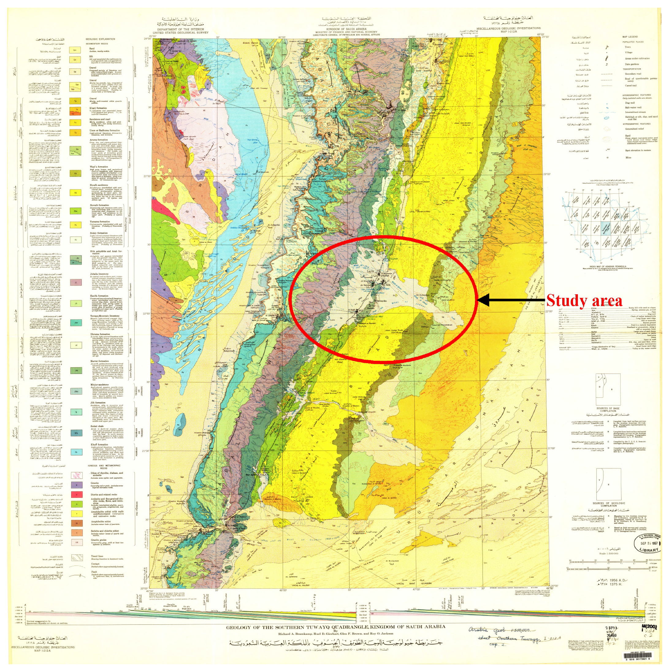
2.1. Description of the Study Area

The study area of 15 ha is located about 25 km south of the City of Laila and north of the City of Al Badi’ea in the province of Al Aflaj, at 22°04’09.5” N, 46°35’26.4” E (22.069306°–46.590667°) at an altitude of 560 m above sea level. It is also located about 30 km east of the Tuwaiq Mountain Escarpment, and about 15 km away from the ancient swamps of the springs of Al Aflaj Oasis. The average monthly temperature of this area typically ranges from 11 to 31 °C in the winter to about 35 to 48 °C in the summer.

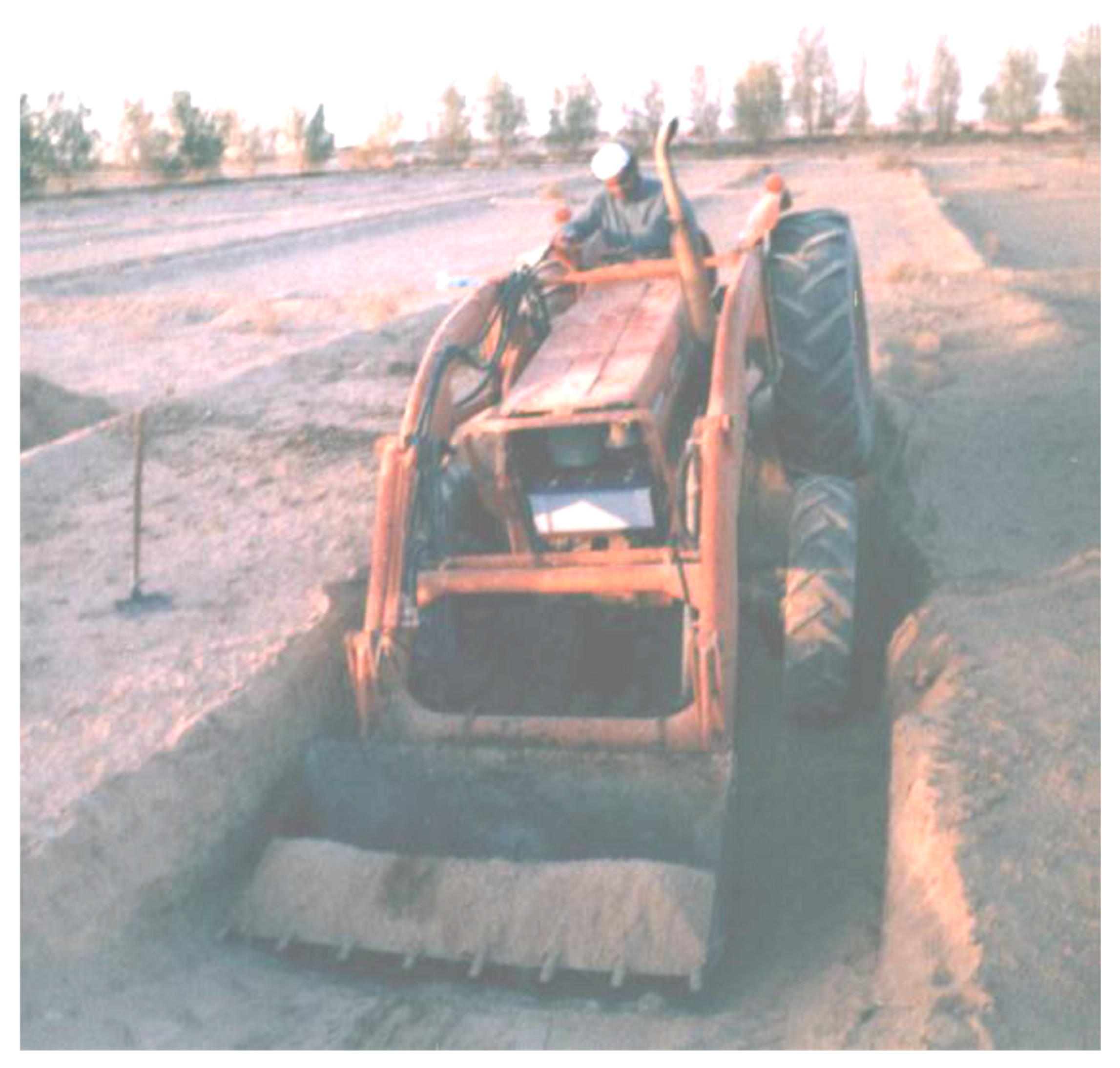
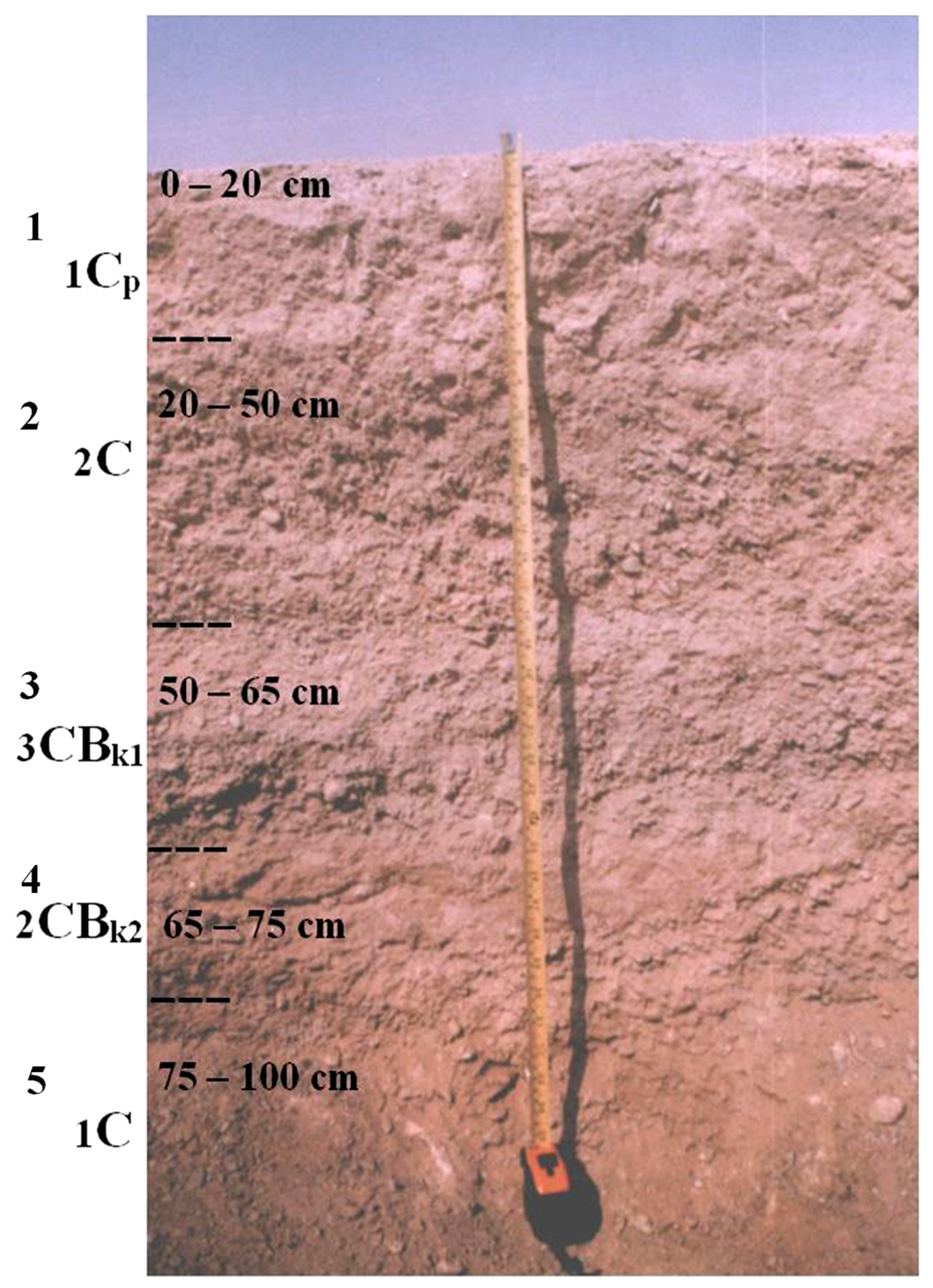
2.2. Soil Profile and Analysis of the Study Samples

The topographic and geological maps of the proposed study area were examined, and appropriate information about the geology and climate of the province of Al Aflaj was collected to identify the earth’s surface forms and the important soil units in the study area, as depicted in Figure 1 [16,17]. Anticipated farms and their surrounding lands were surveyed to study the preliminary properties of soil, and then an inclusive morphological description of the surface of the area was carried out, including descriptions of topography, inclination, and origin material (i.e., parent material), as well as vegetation, drainage, and important surface soil cover. Digging an entire soil profile can be difficult in soils with high limestone, sandstone, and gravel content. Soil samples were collected from field experiments by performing soil profiles using a tractor shovel, hand soil sampling trowel, and bags. The site for the soil profile was chosen, and the profile was excavated to a depth of 100 cm using a tractor shovel with front wheel drive and an engine capacity of 100 hp (Figure 2). The morphology of the chosen soil profile was described, including the description of the sequence of the soil horizons (i.e., 5 layers of the soil profile), the width and depth of each horizon as measured using a belt clip metric ruler tape, and the dry and wet status as determined by color comparison using the Munsell soil color charts, as well as the texture, construction, soil cohesion, soil spots, estimation of the calcium carbonate, boundary of the soil horizons, and any other morphological phenomena. Random soil samples were taken from each layer of the soil profile and transferred to the laboratory to complete the various laboratory analyses (Department of Soil Science in College of Food and Agriculture Sciences at King Saud University).
After selecting the site, the soil was excavated to a depth of 100 cm, and five representative samples of the sequence of the soil horizons were taken. Soil samples were prepared for the following laboratory analyses:
(1)
In a 2 mm thickness sieve, the soil samples were riddled; a portion greater than 2 mm was separated, and the percentage of gravel was estimated based on the total sample mass.
(2)
Soil texture was determined for each layer of the soil profile as follows:
(a)
Soluble salts and calcium carbonate were removed using 0.1 mol L−1 of HCl and washed with distilled water.
(b)
Organic material was removed using 30% hydrogen peroxide (H2O2), followed by washing with distilled water.
(c)
Mechanical analysis of the soil samples was implemented using the pipette method on sieved (under 2 mm, non-rough soil) soil samples.
(d)
The soil sample was scattered by using sodium hexametaphosphate ((NaPO3)6), and then the percentage of silt, clay, and sand were calculated.
(3)
Total calcium carbonate (total CaCO3) was calculated in representative samples using calcimetric analysis through the measurement of the equivalent CO2 volume produced by the interaction of the calcium carbonate (CaCO3) of the soil sample with hydrochloric acid (HCl). The results were used to estimate the amount of calcium carbonate (CaCO3, gkg−1), which was subsequently estimated as a percentage of total mass (%).
(4)
Electrical conductivity (ECe) was measured using an EC-meter (dsm−1), and pH was measured using a pH-meter in the extracted saturated soil paste. The soil saturation ratio (SP) was then measured.
(5)
The organic matter content was estimated by digesting the soil sample in concentrated sulfuric acid with a known amount of potassium bichromate (also called potassium dichromate, K2Cr2O7) and a diphenylamine indicator. An increase in potassium bichromate was measured by the standard calibration of ferrous sulfate (iron sulfate) and 0.01 M ammonium. The organic matter content (gkg−1) of the soil was calculated and subsequently estimated as a percentage (%).

2.3. Statistical Analysis

This study was conducted in the province of Al Aflaj at the study site located north of the city of Al Badi’ea, with a relative survey of the surrounding farmlands. The analysis of the soil case study results focused on the evaluation of the morphological properties of the soil, determining farm soil classifications, and identifying each soil’s agricultural determinants. Statistical analysis via statistical analysis software (SAS) [18] was applied to the results of the physical and chemical analyses to determine the contributing soil properties that could have a significant effect on the soil horizons. One-way analysis of variance (ANOVA) and the least significant difference (LSD) tests at a 95% level of significance (p ≤ 0.05) were utilized simultaneously to clarify the absolute value of the difference between the means and the extent of the interaction effect between the soil horizons and analyzed soil properties.

3. Results

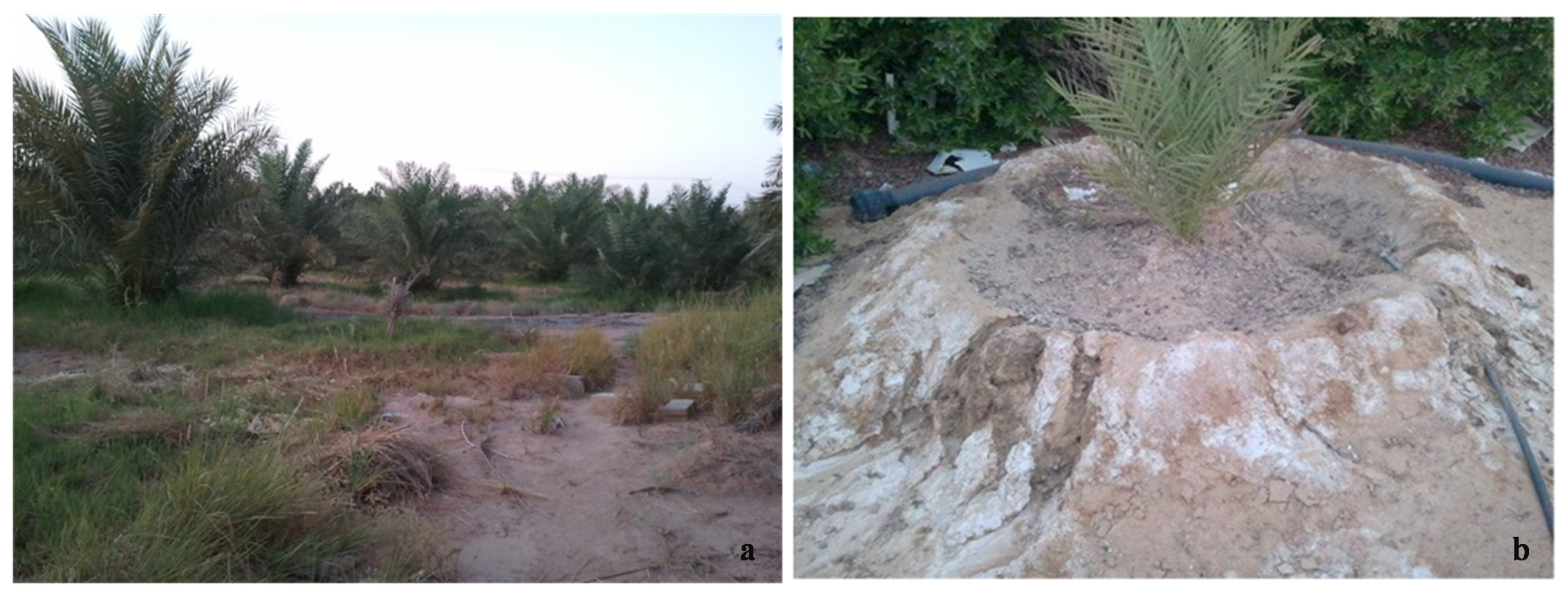
3.1. Morphological Description of the Soil Surface Phenomena

The primary survey showed that there were no significantly different land forms on the top layer of the soil. The entire farm had an appropriate topography (i.e., flat land) with no highlands or lowlands. The entire area of the studied farm was considered open prairie land (plains). Furthermore, this farm was situated 560 m above sea level and had some gravel and limestone covering a few sections of the surface of the top soil. The farm’s topsoil was planted with local crops, such as date palm trees (5 ha) and a forage crop of alfalfa (7 ha), and the remaining farm area had buildings and other facilities (Figure 3). The field crops are irrigated by a modern irrigation piping system, which provides a water supply to the drip and surface irrigation systems, and a center pivot irrigation system (over an almost 40-year period). The irrigation water comes from a 325 m deep-tubing artesian well with a water salinity concentration of 2.90 dsm−1 and a pH of 7.78. As a result of the salt concentration in the irrigation water, the farm’s artesian well is suitable for agricultural use, but the irrigation water is also considered to be only moderate in validity, and plants will be able to tolerate salinity to maintain continuous growth [19]. Based on the climatic conditions and the lack of seasonal rains that occur in dry or semi-dry regions, such as the location of this study, the quality of irrigation water is one of the main factors affecting the health of agricultural crops and agricultural activities in general.
The study also illustrated that with sequential days of irrigation resulting from the high temperature in summer, the amount of annual rainfall is inadequate to wash out and reduce soil salinity, and the effect of the concentration of salts in the newly reclaimed topsoil layers could affect the future drainage and fertility capabilities of the soil types observed on the farm. The high salinity of soil or water could stunt the growth of agricultural crops. To prevent the accumulation of excess salts in some parts of the topsoil layers (Figure 3) and its effect on future cultivation, periodic washing of the soil can be accomplished by adding a large excess of water beyond the irrigation water needs of the cultivated crops (Figure 3). Especially in the event of rainwater scarcity, the method of washing soil with irrigation water or a similar modern technique to drain salinity away from agricultural soil would be best for future cultivation. This could also reduce the effects of salt, even for salt-sensitive plants, improve soil chemical and physical properties, and contribute to a proper irrigation method. The origin materials transported by airstream (winds) were considered the main component of the studied farm’s soil. Sediments, which may have originated in various sandstones and limestone rock that could have been transported by floods resulting from excess heavy rain in this region, were only rarely observed in the farm’s soil.
The morphological study showed that the soil profile was deep (100 cm) until it reached a thick and solid layer with very strong cohesion at 100 cm, which the shovel of the agricultural tractor could not penetrate (Figure 2). This deep soil profile contained several layers totaling five horizons, which were diverse in soil texture and other characteristics, as shown in Figure 4. The soil texture of these horizons was mostly coarse and ranged from sand to sandy loam textures. The colors of the soil profile horizons also varied from brownish red on the top horizon to yellowish red on the other horizons. The soil structure varied depending on the horizon. The top layer of the soil profile showed moderate cohesion. The second and third horizons of the soil profile were an accumulated mass with moderate cohesion. The fourth horizon displayed an accumulated mass that crumbled into unclear little parts, and the lowest (fifth) horizon, from 75 to 100 cm, was a very cohesive accumulated mass.
Furthermore, the morphological study of the soil profile demonstrated that soil elasticity varied under diverse humidity conditions. Some layers showed cohesion in dry conditions, especially the layers under the soil surface, which may indicate the existence of solid layers that are impervious to water; however, the water disintegration test for the cohesive soil of the studied profile demonstrated that the profile horizons disintegrated easily. This confirmed their disintegration with future services and irrigation processes, which further illustrated good soil drainage, especially on the soil surface. In addition, unlike the other horizons of this profile, the soil of the top horizon (the top surface) and the fourth horizon were elastic and cohesive in wet conditions and formed a long cohesive thread. The morphological study of the soil profile also showed evidence of the existence of lime and calcium carbonate accumulations, especially on the subsurface horizons (i.e., the third and fourth horizons of the profile), where the soil effervescence test using acid exposed a large effervescence and a clear gas-releasing sound. Throughout the soil profile, the boundaries between the horizons (layers) were found to be unclear, irregular, and integrated. Finally, the morphological study concluded that there were no significant determinants illustrating agricultural use for most of the studied area. Therefore, the plowing process, which is intended to change the natural properties of the soil, enhance cultivation operations, and serve to encourage the growth of varied crops, only functions on the outermost profile of the soil to a depth of 100 cm.

3.2. Results of Physical and Chemical Analysis of Soil Samples
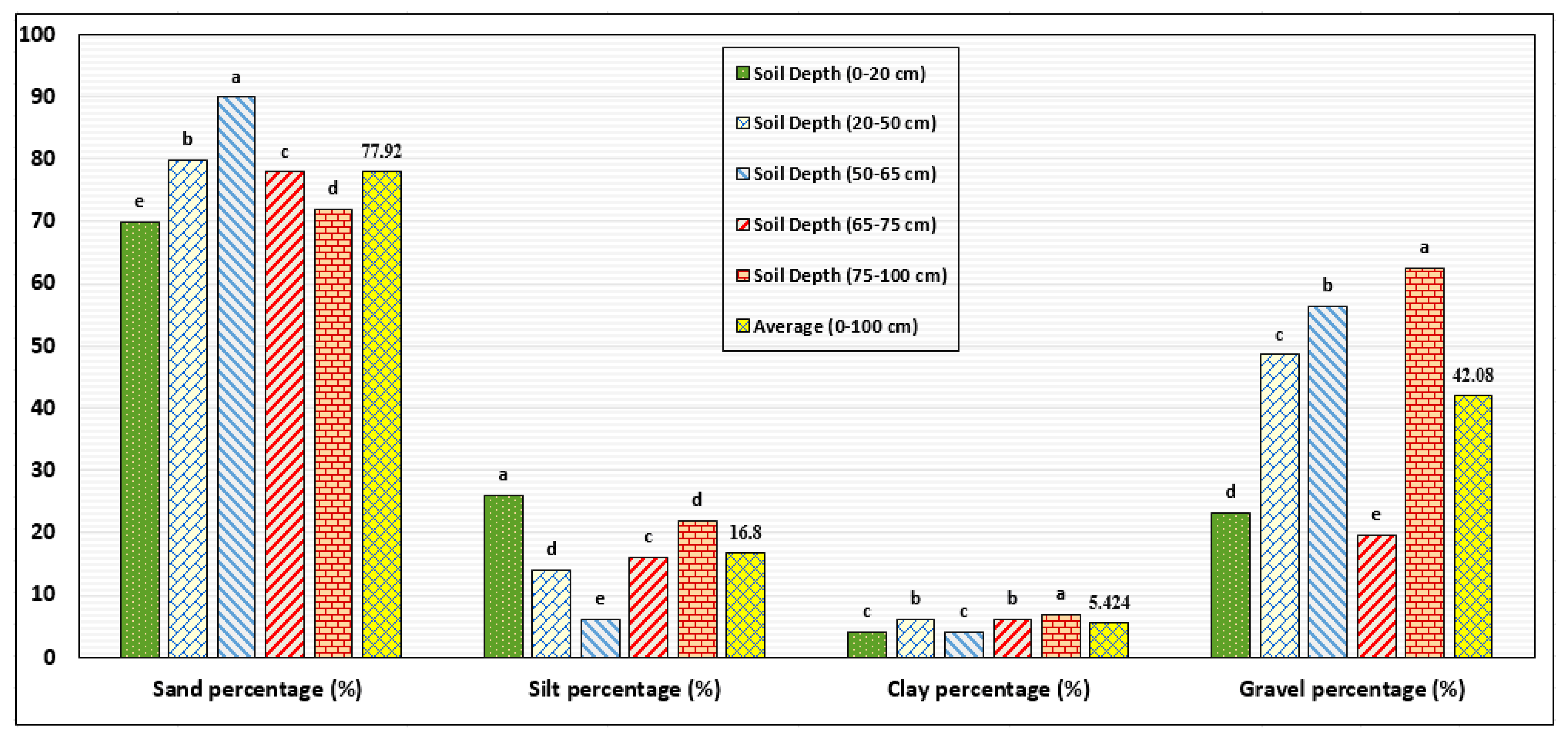
3.2.1. Soil Texture

The soil texture analysis showed that the farm soil was characterized by sand to sandy loam textures and coarse loamy sand textures in the various horizons of the studied soil profile. The horizon of the soil surface had a sandy loam texture that contained 23.20% gravel, which transitioned to a loamy sand texture in the second horizon with an increase in gravel to 48.60%. The texture of the third horizon was sandy, with gravel increasing to about 56.40%, and the percentage of gravel in the fourth lower horizon, which had a loamy sand texture, decreased to less than 19.70%. In the last lower horizon (fifth layer), which had a sandy loam texture, the percentage of gravel increased to the highest level in the soil profile, of 62.50% (Table 1). The physical properties of the soil profile were analyzed statistically at a 95% level of significance to distinguish the most important and significant properties of the soil horizons in the studied area. Thus, by applying the statistical analysis to the physical properties at the 5% level of significance, there were significant differences between the influence of the soil horizons and all analyzed physical properties (as shown in Table 1). These differences in soil texture and gravel percentage were due to the geological sedimentation of the origin material that formed the soil profile (Figure 4). Predominantly, the sand texture and percentage of gravel contained in the soil horizons did not pose problems for farm soil but indicated the limitation of the soil’s capability to retain irrigation water and impair the improvement of soil fertility. As a result, these conditions should be considered in any future efficient soil management, improvement programs, and sustainable development aims.

3.2.2. Calcium Carbonate (CaCO3)

The quantitative analysis of the calcium carbonate (CaCO3) content in the soil samples from all soil profile horizons (Figure 4) indicated the high percentages of lime in the soil, and calcium carbonate percentages ranged between 22 and 64% (Table 2). The lowest percentage of calcium carbonate (22%) was found in the soil sample of the fifth horizon, and the highest percentage of calcium carbonate (64%), which was clearly settled as sediments of raw calcium carbonate (limestone), was found in the soil of the third lower horizon. Consequently, the high rate of lime could increase soil problems and impact soil management efforts, especially regarding the resulting lack of availability of some nutrient elements in the soil, such as phosphorus and some important micro-elements (micronutrients). Therefore, this should be considered in future soil management practices and fertilization programs. In addition, the presence of high calcium carbonate levels in the soil could explain the effect of Al Aflaj springs on the surrounding agricultural lands. According to the statistical analysis, there were obvious significant differences between the effectiveness of the five soil horizons on the calcium carbonate percentage (CaCO3).

3.2.3. Organic Material

Based on the laboratory analysis, the topsoil horizon contained organic material equal to 0.22 and 0.20% (Table 2). In general, the organic material content was higher in the topsoil horizon than in the subsequent horizons, and the organic content continued to decrease with increasing profile depth. The high organic material content in the topsoil horizon is usually due to plant residues and their decomposition since plant roots are commonly distributed only in the topsoil horizon and penetrate less into the lower horizons. Organic content also results from the addition of synthetic organic materials during farming, soil management programs, and other farm practices, especially in the palm tree orchards and alfalfa fields, which can reflect the impact of optimum soil management procedures on the profile’s characteristics and its relative development. Generally, the soil of the studied farm was considered low in its organic content, which affects field crop production and soil microorganism content. Therefore, current low organic soil conditions should be considered for ongoing and future soil management to improve the health of cultivated plants and crop quality. Finally, there was a clear and statistically significant difference in the soil horizons’ influence on the organic material percentage extracted from the soil horizons at the 5% level of significance.

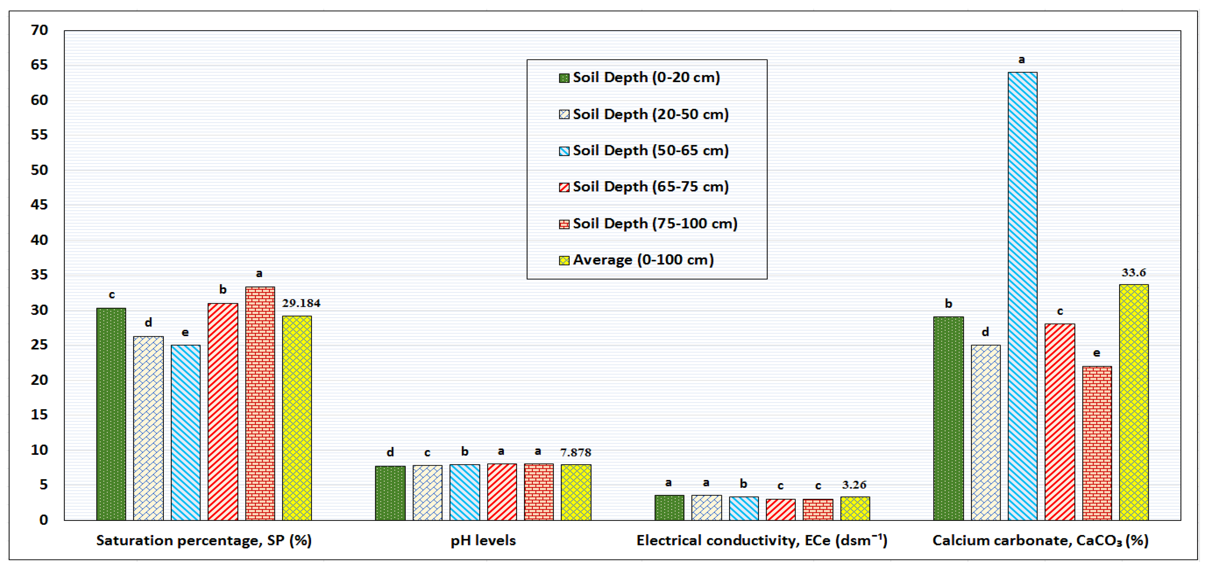
3.2.4. Soil Salinity (ECe) and Percentage of Saturation (SP)

The electrical conductivity (ECe) of the saturated soil paste extract from the studied soil profile horizons was considered as a standard measurement of the concentration of soil salinity and its influence on soil validity for farming purposes. The soil study generally indicated a significant decrease in the concentration of salts in the soil profile horizons to less than 4 dsm−1, which is considered the concentration limit for soil salinity. Salt concentrations ranged between the absolute values of 3 and 3.50 dsm−1 (Table 2), and with the increasing depth of the soil profile, the concentration of salts also decreased. In farmlands that have the same concentration of salts as the soil profile of the considered farm, the effect of salts on the production of most agricultural crops is low, and this concentration of salts is expected to have no effect, even for salt-sensitive plants. Thus, the results of the distribution of salts in the soil profile illustrated that an obvious decrease in the concentration of salts was the result of highly efficient management methods and soil washing processes; however, the amount of salts associated with the irrigation water may be expected to affect the farm soil with successive irrigations in the future. For that reason, both soil and irrigation water salinity should be considered when planning cultivation and soil management programs, as well as when using other appropriate management programs for field crop cultivation, productivity, sensitivity, and ability to adapt to increasing salinity levels.
In addition, conductivity describes the movement of water through saturated soil. According to the texture of the soil, the soil can become saturated with an amount of water that is held between its pores when the air is replaced by water in the minute spaces, and soil aeration will decrease when the saturation percentage is near 100%. This occurs after irrigation and when the groundwater level rises high enough to be discharged to the surface as pooled water bodies or natural surface water flow. Thus, depending on porosity, normal ventilation will be delayed, and all soil pore spaces will be saturated throughout the soil profile. The results of the saturation analysis showed that the highest saturation percentage (SP) reached a value of 33.33% (Table 2). This percentage of saturation is indicative of the coarse soil texture and the arid soil pattern. In this case, in terms of porous soil conditions in which irrigation water or air may pass through its minute spaces easily, the saturation percentage of coarse-textured soils is much less than the saturation percentage of fine soils. However, as shown in Table 2, the obtained data on the chemical properties of the soil profile were analyzed statistically at a 95% level of significance to distinguish the most important and significant properties of the soil horizons of the studied area. Thus, by applying the statistical analysis to the field data at the 5% level of significance, there were obvious significant differences between the influence of the soil horizons and the two analyzed soil properties of electrical conductivity (ECe) and saturation percentage (SP) in the studied soil.

3.2.5. Soil Acidity and Alkalinity (pH)

The soil analysis showed that the pH values tended to be slightly alkaline and ranged between 7.73 and 7.97 (Table 2). Clearly, the pH results for the soil samples of each horizon showed an increasing soil pH as the soil profile depth increased, with the lowest pH at the topsoil horizon and the highest value at the bottom horizon. This is consistent with that indicated by Merdy et al. [20], who showed that the soil formation and system presented in a downhill soil (wetland) act as stores of soil properties. These soil properties can be changeable during the dry seasons, and this change allows alkalinity to be maintained from year to year. It took at least 125 years to obtain downhill soil aggregates with alkaline properties, and the alkaline availability in soil can gradually change with changing drainage conditions. In addition, highly acidic horizons and alkaline horizons can be adjacent. The downhill soil acts as a buffer barrier that maintains the soil and water-stored alkalinity. This also indicates that wet soils, such as Al Aflaj soil, can be storage soil for some of the influential acidity and alkalinity properties over the years. Generally, the pH value at the topsoil horizon can be maintained at that level or lower by adding organic fertilizers along with proper agricultural operations systems, as well as appropriate management programs for crop fertilization and field cultivation. Therefore, there were evident and significant differences between the effects of the five soil horizons on the levels of soil acidity and alkalinity (pH), at a 5% level of significance.

3.3. General Formation and Classification of the Studied Soil

The morphological and chemical properties of the soil profile for the studied farm in Al Aflaj province, as shown in Table 1, Table 2 and Table 3 and Figure 4, indicated that, overall, the farm’s soil had a relatively advanced level of development in its soil profile. The soil showed the formation and development of surface and subsurface diagnostic horizons, and most of the formation in the soil profile had specific properties reflecting the coarse origin material that had created it. A good example is the formation of the Subsurface Calcic Horizon. According to the US classification system (United States Department of Agriculture-USDA: soil taxonomy), the soil profile fits into an appropriate taxonomic unit based on the morphological characteristics of the profile, the texture, and the depth of the profile. The soil profile of this farm is the Aridisols order of dry soils, the suborder of the Calcids, and the great group is Haplocalcids, followed by the subgroup Typic-Haplocalcids [21]. Thus, according to the US classification system, the soil classification of the studied farm was presumed to be beneath the level of the great group subgroup of the Typic Haplocalcids. Based on the classification system of the FAO, Calcisol is one of the soil groups, whether soft or hard at some depths in the soil profile because of its high calcium content. The major determinants of the studied farm soil were the high calcium carbonate ratio, coarse texture, and high gravel ratio. Therefore, according to the classification of the Food and Agriculture Organization of the United Nations (FAO), these soils were classified within the Calcisol soil group with fine to medium texture (i.e., at the classification of moderate arable soils) [22,23].

4. Discussion

The results of this study showed that the agricultural determinants of the soil of the contributing farm and its surrounding farmlands, which were deduced from the studied properties, were few and could be managed and overcome. The most important determinants were the existence of a significant percentage of gravel mixed with the upper surface of the soil, increasing percentages of lime (calcium carbonate) with increasing depth, the pH in the soil profile, the low proportion of loam (clay) and organic material content, and the coarse texture throughout the profile. As shown in the statistical analysis of the data in Table 2, there was no obvious significant difference at a 5% level of significance. Accordingly, the soil profiles did not have an effective influence on the average saturation percentage (SP) or the percentage of calcium carbonate (CaCO3). However, statistical analysis of the data in Table 1 clearly showed, at a 5% level of significance, that the soil profiles did have an effective influence on the average values of the analyzed physical properties of the farm soil.
In addition, investigation of the boundaries of the studied area showed that the contributing farm and the surrounding farmlands might have been affected by the ancient water swamps and springs of the Al Aflaj Oasis, which are distributed northeast of the studied farm. It is clear from the geological maps of Saudi Arabia that Al Aflaj province is located within the famed and ancient valleys in the Oasis of Najd, whose tributaries flow into the zone of Rub’Al Khali (the Empty Quarter Desert) of Saudi Arabia. Additionally, the existence of a water-impermeable subsurface solid layer tends to disrupt the growth of field crops by preventing the extension of plant roots below the soil surface, as well as impeding the capability of palm trees to elongate vertically, and impeding the processes of subsurface drainage. In a similar manner, Shirzaei et al. [24] indicated the importance of studying the effect of floods on crop loss in the American Midwest through Earth observation satellite data and showed that over the past 70 years, 43% of large spring discharges were associated with widespread crop losses. Consequently, the soil determinants, limitations, and undesirable effects on this farmland, as well as similar farmlands that have the same soil conditions, can be reduced or even overcome by considering the following general suggestions that could positively affect soil properties and soil water availability for crops in either arid or semiarid soil conditions:
(1)
The results of this study showed that the predominant texture of the farm soil varied between sandy and sandy loam textures, and a coarse texture (rough properties) was exhibited throughout the entire profile. The contribution percentages of the physical properties of the soil horizons to the total soil texture are indicated in Figure 5. The primary recommendation is to closely follow the service operations for this type of soil, which requires the efficient use of irrigation water, soil fertilizers, and soil amendments. The most important field service operation is the use of a closely monitored modern irrigation system (sprinkler or drip system) and evenly distributing the irrigation periods as much as possible to prevent the loss of added water through seepage into the lower levels. In addition, periodic washing of soil by adding excess water beyond the levels of normal agricultural irrigation, especially with the surface irrigation system, will prevent future fertility limitations and other effects of excess salt build-up in the topsoil horizon resulting from the elevated salinity of the agricultural irrigation water.
(2)
Improving the levels of soil nutrient elements requires a more detailed description and analysis of the farm soil to determine the levels of the major nutrient elements (N, P, and K) and other minor elements (micronutrients such as Fe, Zn, Cu, and Mn). Thus, a soil nutrient improvement program should include an ongoing integrated analysis and management program to monitor and raise nutrient element levels in field soil. This will avoid the disadvantages and damage resulting from decreasing nutrient levels inherent in coarse sandy or limy (Calcic) soils.
(3)
Based on the laboratory analysis, there were statistically significant differences between the soil horizons in their chemical properties. Figure 6 shows the extent to which the chemical properties of the farm soil horizons contribute to the total soil characteristics. However, the chemical and nutritional properties of the soil can be improved through the regular addition of an appropriate quantity and quality of natural organic or manufactured fertilizers, as well as the use of efficient plant and agricultural crop residues with good decomposition rates to increase the soil’s biological activities. These measures increase the ability of various crops to extend their roots into the soil, so soil improvements will persist in the long term. Modern agricultural machines, such as those commonly used for cutting, crushing, separating, grinding, and fragmentation of plant residues, especially residues of palm trees after periodic pruning processes, should be extensively used to minimize the particle size of these residues. Reduced particle size would contribute to quick decomposition of the residues and their integration into the field soil to increase soil fertility and biological activity. As these residues are mixed into the soil, plowing has valuable benefits for improving the soil organic matter content and pH. In addition, the application of sustainability in agriculture using chemical fertilizers could be applied to support the revitalization of poor soil fertility and the enrichment of the range of nutrients available to plants. The application of chemical fertilizers in such arid soils greatly enhances the nutritional health of field plants and thus increases the productivity of crops and fruit (i.e., food production) [25].
(4)
Soil influenced by saline springs may not contribute to emanating plant buds from the soil or to raising the percentage of crop germination, or it may turn into saline soil with a hard surface layer. Improving water management, crop growth, and production in any type of soil can be achieved by predicting the optimal infiltration of irrigation water. Therefore, the use of modern irrigation systems, particularly surface and subsurface drip irrigation systems, along with establishing subsurface drainage channels, would significantly reduce the content of salts and gypsiferous sediments (gypsum) in the soil, resulting in the compression of soil horizons. Furthermore, due to the lack of nutrient elements in the soil, adding chemical materials to the irrigation water is required to increase nutrient levels and overcome the increases in pH and salts. Another recommendation related to water salinity removal includes the use of modern methods and technologies to remove salts from irrigation water, such as magnetic system procedures for cracking and salt detachment.
(5)
An additional recommendation includes the regular execution of periodic harrowing and tillage of the soil, especially sub-surface plowing using a plow under the soil surface (e.g., chisel and furrow plows, deep cultivator digger), to break up the subsurface solid layer at 100 cm. This will also reduce the consolidation of soil, allow the field crops to extend their roots more easily and evenly into the lower soil horizons, and improve the overall physical properties of the farm soil. Other scientific studies in fields that have soils similar to the sandy loam soil of the studied farm showed that the use of deep cultivator diggers (chisel plows) in a field of blended soil that had a combination texture of silt, clay, and loam soil (silty clay loam soil) achieved better performance and lower total operating costs when compared to other plowing machines, such as disc and moldboard plows [26]. The plow under the soil surface (deep cultivator digger) also provides the best performance in breaking down solidity in the subsurface soil, with an increase in the soil porosity suitable for the extension of crop roots [27]. Additionally, in sandy clay loam soil, tractor performance improves with the lowest percentage of wheel tractor slip when operated with the deep cultivator digger (chisel plow), which exhibits the least resistance to soil penetration under an appropriate plowing depth and soil moisture conditions [28]. To improve some of the physical properties of the soil, Ali et al. [29] recommended the use of a moldboard plow when dealing with soils of sedimentary origin. The moldboard plow operation afforded good performance in providing a suitable hotbed (seedbed) for crop growth, the highest productivity of field crops (e.g., alfalfa, sorghum, and maize), better soil moisture, and smaller soil aggregate size (prevention of the massive structures of plowed soil).
(6)
It is important to conduct a more detailed study of the subject farm to build a varied crop structure that is suitable for the properties of the soil of this farm while considering the farm irrigation water quantity and quality. In general, the major determinants of this study area were the high calcium carbonate rate, coarse texture, and high gravel ratio; however, the study area was considered appropriate for agricultural activity. Therefore, studying and analyzing soil properties for land reclamation and the restoration of vegetation by providing more effective soil in areas that have been submerged in water for many years is particularly important for optimum agricultural investments. Therefore, it is recommended that more attention is given to lands that are high in calcium carbonate, poor in organic matter, and have been significantly affected by spring surface water flow for a long period of time.
(7)
In summary, the primary findings of the intended land capability evaluation were that soil levels have the potential to provide sufficient information to clarify the effect of ancient water springs on soil texture, stages of vegetative growth and production of plants, and cultivation systems in the Al Aflaj area. However, it is important to perform more detailed studies of the surrounding farmlands and the effects of Al Aflaj springs (pools of water) and their Khariz (Qanats—ancient subsurface irrigation canals)—on the soil structure and types, its properties, and future agriculture activities in the area. There is a high probability that this region of agricultural farmlands had been submerged in the water of the Al Aflaj Oasis springs in the ancient past, and the area of Qussayrat Ad, which is located in the east, is the best evidence to prove the existence of an ancient agricultural civilization around the study area.
Finally, the main advantages resulting from the use of efficient soil and agricultural equipment management are as follows: diversifying crop cultivation and contributing significantly to changing agricultural field operating practices; reducing the cost of growing plants and cultivation in general; and economy in the operation of agricultural equipment, including soil tillage equipment. Future cultivation should include deep plowing to fragmentize the solid structure of the soil and facilitate suitable farming practices, such as depth plowing rotations, which could positively affect soil properties and enhance droplet sedimentation to maximize soil water availability for crops in either arid or semiarid soil conditions and plant growth, especially for palm tree plantations. In addition, due to the effect of the ancient oasis spring floods, Imperata Cylindrica L. (Cogongrass) grows densely (Figure 3), so the growth of this weed must be prevented, and successive plowing operations will help prevent its growth. Ultimately, optimum field performance and soil structure for carrying out future plant cultivations in the arid lands, such as those of the Al Aflaj Oasis, which were affected by the overflow of water from the Al Aflaj springs in the ancient past, can be consistent with the operation of other types of agricultural equipment, such as chisel tillage of the soil. This is in agreement with Tyagi et al. [30], who indicated that maintaining tillage operations with effective practices for managing water and soil nitrogen is promising as an applicable alternative to conventional farming techniques.

5. Conclusions

This study provides a useful concept for the management of arid soil that was affected by an ancient spring flood and the use of appropriate plowing implements during field operations to provide loose soil that can contribute to helping crops grow and adhere to the soil. Therefore, sustainable agriculture on such arid lands as the Aflaj Oasis can be applicable through the optimal application of the operations of agricultural implements and their relation to the soil and appropriate environment for the growth of field plants. This research showed that field performance and soil element consumption for field crops is consistent with other crop and machine operations that have been studied in previous scientific papers and were confirmed by reliable references to, for example, studies in the literature in this article, where the recommendations would ensure soil development and improvement, sustainable growth of agricultural crops (food productivity), availability of the necessary soil elements for crop diversity and environmental sustainability, plant health, growth, and the expansion of plant roots in loose and light soil that does not contain any cohesive layers during the cropping season. This study demonstrated crucial confidence in allowing a diversity of plants to implant, whether seasonal crops (in surface soil to a depth of less than 100 cm) or perennial plants, such as planting perennial palm trees, which need to break the solid layer at a depth of 100 cm. Moreover, farmers in such an arid area historically affected by surface spring water flow can predict a structured approach to managing the planting operations of any selected plants, tillage, and cultivation processes, or any appropriate soil management practices, and other agricultural information, such as fertilizer diversity, soil leaching, and the mechanized tillage operations at required depths, which will be most considerable for future cultivation.

Funding

This research received no external funding.

Institutional Review Board Statement

Not applicable.

Informed Consent Statement

Not applicable.

Data Availability Statement

All data are presented in this article in the form of figures and tables.

Acknowledgments

My sincere thanks to the owner of the Al Aziziyah farm, Mohammad Nahedh Made’th Al-Sakhabrah and his brothers and cousins for allowing us to perform this study in their farmstead and take some samples from the farm soil profiles. I would also like to thank all the staff of the Department of Soil Sciences at the College of Food and Agriculture Sciences for their cooperation and contribution in analyzing the soil samples and recording the results. My sincere respect and gratitude to the Deanship of Scientific Research, Researchers Support Services Unit, and Agricultural Research Center at the College of Food and Agriculture Sciences, King Saud University for their moral support and recommendations.

Conflicts of Interest

The author declares that there is no conflict of interest that could affect the publication of this article.

References

  1. Ministry of Environment, Water & Agriculture. Agriculture Statistical Year Book; No. 27; Agricultural Research and Development Affairs (Formerly), Department of Economic Studies and Statistics: Riyadh, Saudi Arabia, 2014. (In Arabic)
  2. Ministry of Environment, Water & Agriculture. Agriculture Statistical Year Book-2018; Deputy-Ministry for Economic Affairs and Investment, General Administration of Information and Statistics: Riyadh, Saudi Arabia, 2019; p. 209. Available online: https://www.mewa.gov.sa/ar/InformationCenter/Researchs/Reports/GeneralReports/%D8%A7%D9%84%D9%83%D8%AA%D8%A7%D8%A8%20%D8%A7%D9%84%D8%A5%D8%AD%D8%B5%D8%A7%D8%A6%D9%8A%201439-1440%D9%87%D9%80%20sp%202.pdf (accessed on 9 September 2020). (In Arabic)
  3. Al-Mashhady, A.S.; Sheta, A.S.; Sallam, A.S. Soil Types and Agricultural Management Methods in the Kingdom of Saudi Arabia; Agricultural extension bulletin number 68; Agricultural Extension Center, College of Food and Agricultural Sciences, King Saud University: Riyadh, Saudi Arabia, 1998. (In Arabic) [Google Scholar]
  4. Ministry of Environment, Water & Agriculture. General Soil Map of the Kingdom of Saudi Arabia (Soil Atlas); Department of Lands Investment Management (Formerly): Riyadh, Saudi Arabia, 1986. (In Arabic)
  5. Ministry of Environment, Water & Agriculture. Atlas of Land Resource; Department of Lands Investment Management (Formerly): Riyadh, Saudi Arabia, 1995. (In Arabic)
  6. Sheta, A.S. Soil Quality: Standards of Soil Quality under the Conditions of Saudi Arabia, 7th ed.; Saudi Society for Agricultural Sciences, King Saud University: Riyadh, Saudi Arabia, 2004. (In Arabic) [Google Scholar]
  7. Al-Barrak, S.A. Characteristics and classification of some coastal soils of Al-Ahsa, Saudi Arabia. J. King Saud Univ. Agric. Sci. 1997, 9, 319–333. Available online: http://ksupress.ksu.edu.sa/Ar/Lists/JournalAricle/Attachments/2456/V9M115R2875.pdf (accessed on 9 May 2020).
  8. Youssef, A.F. Soil distribution pattern and gypsic soils of Alqatif Oasis, Saudi Arabia. J. King Saud Univ. Agric. Sci. 1991, 3, 127–138. Available online: http://ksupress.ksu.edu.sa/Ar/Lists/JournalAricle/Attachments/1342/V3M198R1514.pdf (accessed on 9 May 2020).
  9. Al-Mashhady, A.S.; Reda, M.; Hammad, M.A. Soil association of Al-Qassim region, Saudi Arabia. J. King Saud Univ. Agric. Sci. 1991, 3, 149–165. Available online: http://ksupress.ksu.edu.sa/Ar/Lists/JournalAricle/Attachments/1340/V3M198R1512.pdf (accessed on 9 May 2020).
  10. Youssef, A.F. Bediology: Soil Origin, Morphology, and Classification; Deanship of Library Affairs, King Saud University: Riyadh, Saudi Arabia, 1987. (In Arabic) [Google Scholar]
  11. Al-Barrak, S.A. Characterization and classification of some soils in Al-Sawdah, southwestern Saudi Arabia. J. King Saud Univ. Agric. Sci. 1985, 7, 269–283. Available online: http://cfas.ksu.edu.sa/en/content/soil-pedology-and-mineralogy (accessed on 9 May 2020).
  12. Sheta, A.S.; Al-Sewailem, M.S.; Sallam, A.S.; Al-Amry, A.M. Pedological characteristics of the soils of Wadi Bishah in southwestern region, Saudi Arabia. J. King Saud Univ. Agric. Sci. 2004, 17, 47–62. Available online: https://www.researchgate.net/publication/281678074 (accessed on 9 May 2020).
  13. Al-Nashwan, A.A. Al Aflaj Area, a Field Geographical Study; Al-Rushed Library: Riyadh, Saudi Arabia, 1990. (In Arabic) [Google Scholar]
  14. Philby, H.S.J.B. Two notes from Central Arabia: The pools of Aflaj. Geogr. J. 1949, 113, 86–93. [Google Scholar] [CrossRef]
  15. Ministry of Environment, Water & Agriculture. Statistics of Agricultural Census By Kingdom’s Agricultural Directorates 1999; Agricultural Research and Development Affairs (Formerly), Department of Economic Studies and Statistics: Riyadh, Saudi Arabia, 2001. (In Arabic)
  16. Ministry of Finance and National Economy. Geological Map of the Southern Ferrule Plate in Saudi Arabia: Map No. 212A-I; Directorate General of Oil and Minerals, Ministry of Finance and National Economy, US Geological Survey, Ministry of Interior (Formerly): Riyadh, Saudi Arabia, 1956. (In Arabic)
  17. USGS-United States Geological Survey. Geology of the Southern Tuwayq Quadrangle, the Kingdom of Saudi Arabia, Map: I-212 A, 1956, USA. 2012. Available online: https://pubs.usgs.gov/imap/0212a/plate-1.pdf (accessed on 12 May 2020).
  18. SAS Institute Inc. SAS User’s Guide Statistics: SAS® 9.4 Graph Template Language, 5th ed.; SAS Institute Inc.: Cary, NC, USA, 2016; Available online: https://documentation.sas.com/api/docsets/grstatug/9.4/content/grstatug.pdf?locale=en (accessed on 15 September 2020).
  19. FAO-Food and Agriculture Organization of the United Nations. Salt-Affected Soils and their Management: Water Quality and Crop Production; FAO Soils Bulletin 39 (M-53); Food and Agriculture Organization of the United Nations: Rome, Italy, 1988; ISBN 92-5-102686-6. Available online: http://www.fao.org/3/x5871e/x5871e07.htm (accessed on 9 September 2020).
  20. Merdy, P.; Gamrani, M.; Montes, C.R.; Rezende Filho, A.T.; Barbiero, L.; Ishida, D.A.; Silva, A.R.C.; Melfi, A.J.; Lucas, Y. Processes and rates of formation defined by modelling in alkaline to acidic soil systems in Brazilian Pantanal wetland. Catena 2021, 210, 105876. [Google Scholar] [CrossRef]
  21. USDA-United States Department of Agriculture. Soil Taxonomy: A Basic System of Soil Classification for Making and Interpreting Soil Surveys. Agriculture Handbook, 2nd ed.; No. 436; United States Department of Agriculture, Natural Resources Conservation Service: Washington, DC, USA, 1999. Available online: https://www.nrcs.usda.gov/Internet/FSE_DOCUMENTS/nrcs142p2_051232.pdf (accessed on 12 May 2020).
  22. FAO-Food and Agriculture Organization of the United Nations. World Reference Base for Soil Resources 2014: International Soil Classification System for Naming Soils and Creating Legends for Soil Maps; World Soil Resources Reports No. 106; 2015; ISBN 978-92-5-108369-7. Available online: http://www.fao.org/3/i3794en/I3794en.pdf (accessed on 9 September 2020).
  23. Sposito, G. Soil: FAO Soil Groups; Encyclopaedia Britannica Inc.: Chicago, IL, USA, 2020; Available online: https://www.britannica.com/science/soil/FAO-soil-groups (accessed on 9 September 2020).
  24. Shirzaei, M.; Khoshmanesh, M.; Ojha, C.; Werth, S.; Kerner, H.; Carlson, G.; Sherpa, S.F.; Zhai, G.; Lee, J.C. Persistent impact of spring floods on crop loss in U.S. Midwest. Weather. Clim. Extrem. 2021, 34, 100392. [Google Scholar] [CrossRef]
  25. Al-Dosary, N.M.N.; Abdel-Sattar, M.; Aboukarima, A.M. Effect of Ammonium Sulphate Incorporated with Calcium Nitrate Fertilizers on Nutritional Status, Fruit Set and Yield of Pomegranate Trees cv. Wonderful. Agronomy 2022, 12, 971. [Google Scholar] [CrossRef]
  26. Jasim, A.A.; Jebur, H.A. Impact of primary tillage system on fuel consumption, management, and total tractor costs. Baghdad Univ. Iraqi J. Agric. Sci. 2015, 46, 31–35. Available online: https://www.iasj.net/iasj?func=fulltext&aId=95609 (accessed on 6 January 2021). (In Arabic with English Abstract).
  27. Al-Khafaji, A.J. Effect of subsoiler plowing depth on the removing of hardpan and corn yield. Univ. Kufa Kufa J. Agric. Sci. 2009, 1, 21–29. Available online: https://www.iasj.net/iasj/download/6991da9b6943bbf2 (accessed on 6 January 2021). (In Arabic with English Abstract).
  28. Mamkagh, A.M.A. Some factors affecting the wheel slip of a 2WD farm tractor. Univ. Jordan Jordan J. Agric. Sci. 2009, 5, 519–525. Available online: https://journals.ju.edu.jo/JJAS/article/view/866-1744-1-SM (accessed on 6 January 2021). (In Arabic with English Abstract).
  29. Ali, K.M.; Tahir, M.A.; Abd Alamer, H.K. Influence of plowing system on zea maize production and some soil characteristics. AL-Taqani Iraqi Found. Tech. Educ. 2011, 24, 260–268. Available online: https://www.iasj.net/iasj?func=fulltext&aId=29589 (accessed on 6 January 2021). (In Arabic with English abstract).
  30. Tyagi, S.; Naresh, R.K.; Bhatt, R.; Chandra, M.S.; Alrajhi, A.A.; Dewidar, A.Z.; Mattar, M.A. Tillage, Water and Nitrogen Management Strategies Influence the Water Footprint, Nutrient Use Efficiency, Productivity and Profitability of Rice in Typic Ustochrept Soil. Agronomy 2022, 12, 1186. [Google Scholar] [CrossRef]
Figure 1. Geological map of the Southern Tuwaiq Plateau in the Kingdom of Saudi Arabia that includes the soil profile area of this study (Al Aflaj Oasis) [16,17]; Map information can be clearly viewed with zoom in and out at https://pubs.usgs.gov/imap/0212a/plate-1.pdf (accessed on 3 June 2022). Source: adapted from https://pubs.usgs.gov/imap/0212a/ (accessed on 3 June 2022).
Sustainability 14 07991 g001
Figure 2. The difficulty of digging the soil profile.
Sustainability 14 07991 g002
Figure 3. The farm’s vegetation cover: (a) Palm trees and an intensive growth of the Imperata Cylindrica L (Cogongrass) weed; (b) stunted growth on palm trees, quality of soil washing, and effect of irrigation water salinity on the farm soil surface.
Sustainability 14 07991 g003
Figure 4. The prospects of the soil sector boundary, symbol of each horizon, and depth of the soil profile.
Sustainability 14 07991 g004
Figure 5. Predominant texture of the farm soil for each soil horizon. Data followed by the same letter on each column for each individual physical property are not significantly different at a 5% level of significance.
Sustainability 14 07991 g005
Figure 6. Chemical properties of the soil horizons. Data followed by the same letter on each column for each individual chemical property are not significantly different at a 5% level of significance.
Sustainability 14 07991 g006
Table 1. Physical properties of the studied soil profile (analysis results of the soil profile horizons).
Particle Size Distribution of the Granules Soil
No. of Soil Profile
Horizon
Depth of Soil Profile (cm)Sand Percentage
(%)
Silt Percentage
(%)
Clay Percentage
(%)
Gravel Percentage
(%)
Texture Class
100–2069.92 e26 a4.08 c23.20 dGravelly sandy loam
220–5079.92 b14 d6.08 b48.60 cGravelly loamy sand
350–6589.92 a6 e4.08 c56.40 bVery gravelly sand
465–7577.92 c16 c6.08 b19.70 eGravelly loamy sand
575–10071.92 d22 b6.80 a62.50 aVery gravelly sandy loam
Average00–10077.92 a16.80 c5.424 d42.08 b
Data followed by the same letter in each column are not significantly different at a 0.95 confidence level. Averages followed by the same letter in the bottom row are not significantly different at a 5% level of significance.
Table 2. Chemical properties of the studied soil profile (analysis results of the soil horizons).
No. of Soil Profile
Horizon
Depth of
Soil Profile
(cm)
Saturation
Percentage, SP (%)
Ph LevelsElectrical
Conductivity, Ece (Dsm−1)
Calcium
Carbonate, Caco3 (%)
Organic
Material Percentage
(%)
100–2030.33 c7.73 d3.50 a29 b0.22 b
220–5026.26 d7.79 c3.50 a25 d0.20 c
350–6525.00 e7.93 b3.30 b64 a0.03 d
465–7531.00 b7.97 a3.00 c28 c0.03 d
575–10033.33 a7.97 a3.00 c22 e0.27 a
Average00–10029.184 a7.878 b3.260 b33.600 a0.150 b
ECe (dsm−1): electrical conductivity of the soil-saturated extract (a measure of the soil salinity), the concentration of salts in ppm is calculated from the following equation: ppm = ECe (dsm−1) × 640. SP (%): soil saturation percent (grams of water required to saturate 100 g of soil ). Data followed by the same letter in each column are not significantly different at a 0.95 confidence level. Averages followed by the same letter in the bottom row are not significantly different at a 5% level of significance.
Table 3. Description of the studied soil profile horizons (analysis result of each soil horizon).
Depth of Soil Profile (cm)Symbol of Each Soil HorizonDescription of Each Soil Profile Horizon
00–201Cp10 YR 7/4 Pink (dry), 10 YR 5/6 Strong brown (moist).
The soil has an accumulated and cohesive structure, slight hardness of structure with a percentage of gravel, adhesive, plastic, medium roots, and integrated wavy boundaries.
20–502C7.5 YR 6/6 reddish yellow (dry), 7.5 YR 5/6 yellowish red (moist).
A less cohesive mass structure, with a percentage of gravel, few roots, and integrated wavy boundaries.
50–653CBk17.5 YR 6/6 reddish yellow (dry), 7.5 YR 5/6 yellowish red (moist).
Soil with a less cohesive accumulated structure, with a percentage of gravel, integrated wavy boundaries, and soft accumulated limestone.
65–752CBk27.5 YR 6/6 reddish yellow (dry), 7.5 YR 4/6 yellowish red (moist).
The soil has a less cohesive accumulated structure, less soil structure with a percentage of gravel, adhesive, plastic, integrated wavy boundaries, and soft accumulated limestone.
75–1001C7.5 YR 6/6 reddish yellow (dry), 7.5 YR 5/6 yellowish red (moist).
The soil has a cohesive mass structure with accumulated limestone, less solid structure with a proportion of gravel, a slightly adhesive structure, and wavy boundaries.
General classification of the soil profileTypic Haplocalcids
Publisher’s Note: MDPI stays neutral with regard to jurisdictional claims in published maps and institutional affiliations.

