Abstract
Safety is a major worldwide concern due to the increasing number of fatalities of vulnerable road users (VRUs). VRUs are pedestrians, bicyclists, and motorcyclists, and their safety is a priority when making infrastructure management decisions. Traditionally, transportation agencies have adopted transportation asset management (TAM) practices based on performance measures to assess the physical condition of transport infrastructure. This paper describes a framework to incorporate VRU’s safety into the TAM decision-making process. The main objective of the VRU-TAM framework is to mitigate pedestrian fatalities by improving the decision-making process at the strategic and operational management level. The VRU-TAM framework is composed of four phases: assessment, prioritization, scenario analysis, and results. It includes a prioritization methodology using a safety-weighted effectiveness ratio (SWER) to consider pedestrian safety factors and costs in the decision-making process. In a broader perspective, pedestrian safety is affected by driver, demographic, pedestrian, infrastructure, and policy related factors. The decision-making criteria reflected in SWER considers the asset importance, location, pedestrian safety risk, costs, and remaining life in the budget allocation process, and adopts the dynamic bubble up (DBU) technique for budget prioritization at the network level. An example is presented for crosswalks to demonstrate the applicability of the methodology to evaluate different budget-driven scenarios for funding allocation. As a conclusion, it is demonstrated that the outcomes of the budget-driven scenarios following the method that incorporates safety criteria, with tangible metrics, offer a deeper understanding of the effects of budgetary constraints on backlog costs and the remaining life of infrastructure assets.
1. Introduction
Road safety is a major concern due to an estimate of 1.35 million fatalities worldwide every year [1,2]. Pedestrians and bicyclists are vulnerable road users (VRUs), with lesser protection to the effects of motorized traffic due to the absence of an external protective cover (e.g., airbags, bumpers, metallic guards). According to the World Health Organization [1], the percentage of fatalities involving pedestrians, bicyclists, and motorcyclists represents more than 50% of the total traffic-related deaths around the world.
In the United States, the Moving Ahead for Progress in the 21st Century Act (MAP-21) and the Fixing America’s Surface Transportation Act (FastAct) state that agencies must concentrate their efforts on road safety as their priority goal for transport infrastructure [3]. MAP-21 was signed in 2012, fostering investments in transport infrastructure, and FastAct was signed in 2015, providing long-term funding resources for surface transportation infrastructure planning and investments [4,5]. At present, the Federal Highway Administration (FHWA) collaborates with the United States Department of Transportation (USDOT) and other organizations to support safety initiatives, including the Road to Zero, Toward Zero Deaths, and Vision Zero. In 2018, the Road to Zero Coalition published a report with strategies to decrease motor vehicle fatalities, outlining measures to eradicate traffic fatalities in the United States by 2050 [6]. Toward Zero Deaths (TZD) is a highway safety strategy developed in the U.S. by professionals, researchers, and advocates from a range of fields to reduce the number of annual fatalities on U.S. roads to zero [7]. Vision Zero was first launched in Sweden in the 1990s, with the goal to end road fatalities and serious injuries while promoting equitable, safe, and healthy mobility for all road users. It has been a successful program throughout Europe, and currently, it is adopted by departments of transportation in the U.S. [8].
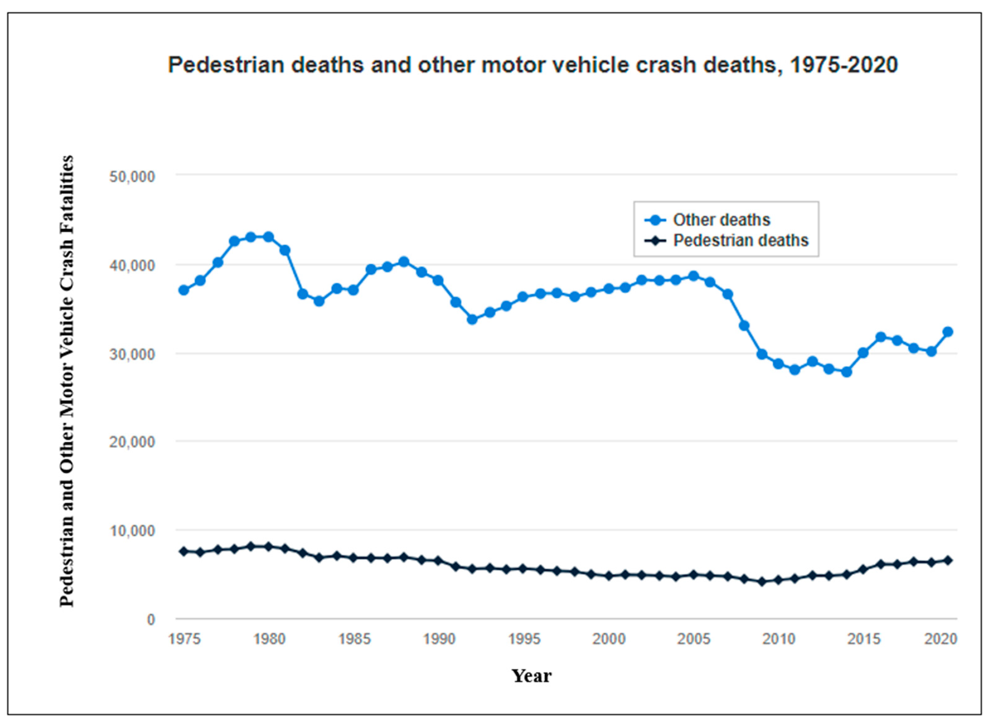
Despite all these efforts, according to a study conducted by the Insurance Institute for Highway Safety (IIHS) in 2020, pedestrian deaths have increased by 59% since 2009, as shown in Figure 1 [9]. This reinforces the need to improve governmental policies to foster investments toward safety improvements in transport infrastructure, and to implement asset management practices that explicitly consider safety criteria, with tangible metrics, in the decision-making process.
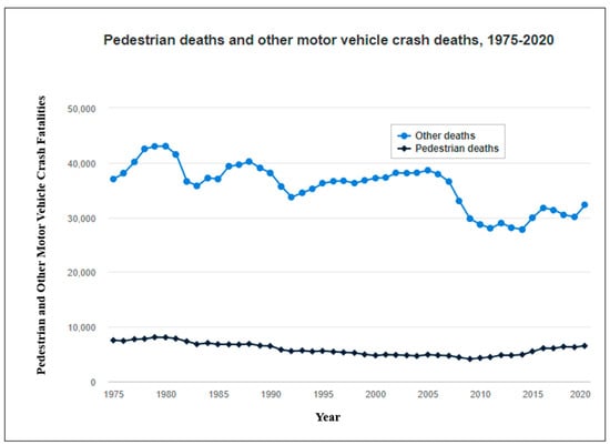
Figure 1.
Pedestrian deaths and other motor vehicle crash deaths (1975–2020) (adapted from [10]).
In 2022, the new Safe Streets and Roads for All (SS4A) discretionary program was established by the Bipartisan Infrastructure Law (BIL) with USD 5 billion in appropriated funds over the next 5 years [11]. The Infrastructure Investment and Jobs Act (IIJA) restores and upgrades every state’s transportation system. A five-year extension of the federal surface transportation program, including a USD 450 billion investment in highway, bridge, public transportation, and safety improvements is at the heart of the new law, accounting for more than half of the IIJA’s total investments. The law authorizes USD 1.2 trillion for transportation and infrastructure spending, with USD 550 billion allocated towards “new” investments and program implementation [12]. In addition to governmental policies and legislation, a strategic and systematic decision-making approach that considers safety for all road users should be implemented in the funding allocation process for transport infrastructure.
Transportation asset management (TAM) is “a strategic and systematic process of operating, maintaining, upgrading, and expanding physical assets throughout their lifecycle” [13]. TAM involves a complex decision-making process to preserve transport infrastructure in a “state of good repair” in the most cost-effective manner. Traditionally, performance measures related to physical infrastructure conditions are used by infrastructure management systems to recommend candidate projects for funding allocation, although safety factors are not integrated into the prioritization criteria. For this reason, there is a need to incorporate safety criteria, with tangible metrics, into TAM practices. The motivation of this paper is to improve safety for all users by the development of a comprehensive methodology that integrates safety criteria into TAM.
This paper proposes a framework that incorporates VRU safety criteria, with tangible metrics, into the TAM decision-making process. The VRU-TAM framework includes four phases: assessment, prioritization, scenario analysis, and results. The VRU-TAM framework incorporates safety indices used by the agencies to identify safety conditions considering asset importance, location, maintenance costs, and remaining service life. A safety-weighted effectiveness ratio (SWER) integrates all these factors into a single cost-effective safety index to facilitate the budget allocation process. An example focused on pedestrian safety is presented for crosswalks to evaluate different budget-driven scenarios for funding allocation. As a conclusion, it is demonstrated that the outcomes of the budget-driven scenarios following the method that incorporates safety criteria offer deeper understanding of the effects of budgetary constraints on the remaining life of infrastructure assets and backlog costs. The VRU-TAM framework can be implemented to support management decisions at the strategic and operational level.
The paper is organized in six sections. This introduction explains the motivation and objectives, with a brief overview of the content. The Section 2 is a literature review about the main factors affecting pedestrian safety and a summary of safety indexes. In the Section 3, the methodology to incorporate VRU safety criteria into TAM is described. The Section 4 presents data collection approaches for different budget-driven scenarios. The Section 5 provides comments about the results of the budget-driven analysis. Finally, the Section 6 summarizes the main findings, conclusions, and prospective directions for further research.
2. Literature Review
The U.S. is facing a serious problem with pedestrian safety that is evidenced by the high rate of fatalities and its significant contribution to the total traffic deaths. From 2010 to 2019, the number of pedestrian fatalities that occurred in the dark increased from 3030 to 4660 deaths. Furthermore, pedestrian deaths as a percentage of total motor vehicle crash deaths increased from 13% in 2010, to 17% in both 2018 and 2019 [14]. According to a study, there were 1.04 pedestrian deaths per 100,000 persons countrywide in 2019, up from 0.90 in both 2020 and 2019. The incidence of vehicles striking and killing pedestrians increased to 2.3 deaths per billion vehicle miles traveled (VMT) in the first 6 months of 2021. This is an increase in the number of pedestrian fatalities from the historically high rate of 2.2 deaths per billion VMT in 2020, and much higher than the rate of 1.8–1.9 deaths per billion VMT in 2017–2019 [10]. Therefore, there is a need to improve safety conditions for all road users, including pedestrians and bicyclists, who are considered vulnerable road users (VRUs), since they are exposed to greater risks than motorists.
2.1. Factors Influencing Pedestrian Safety
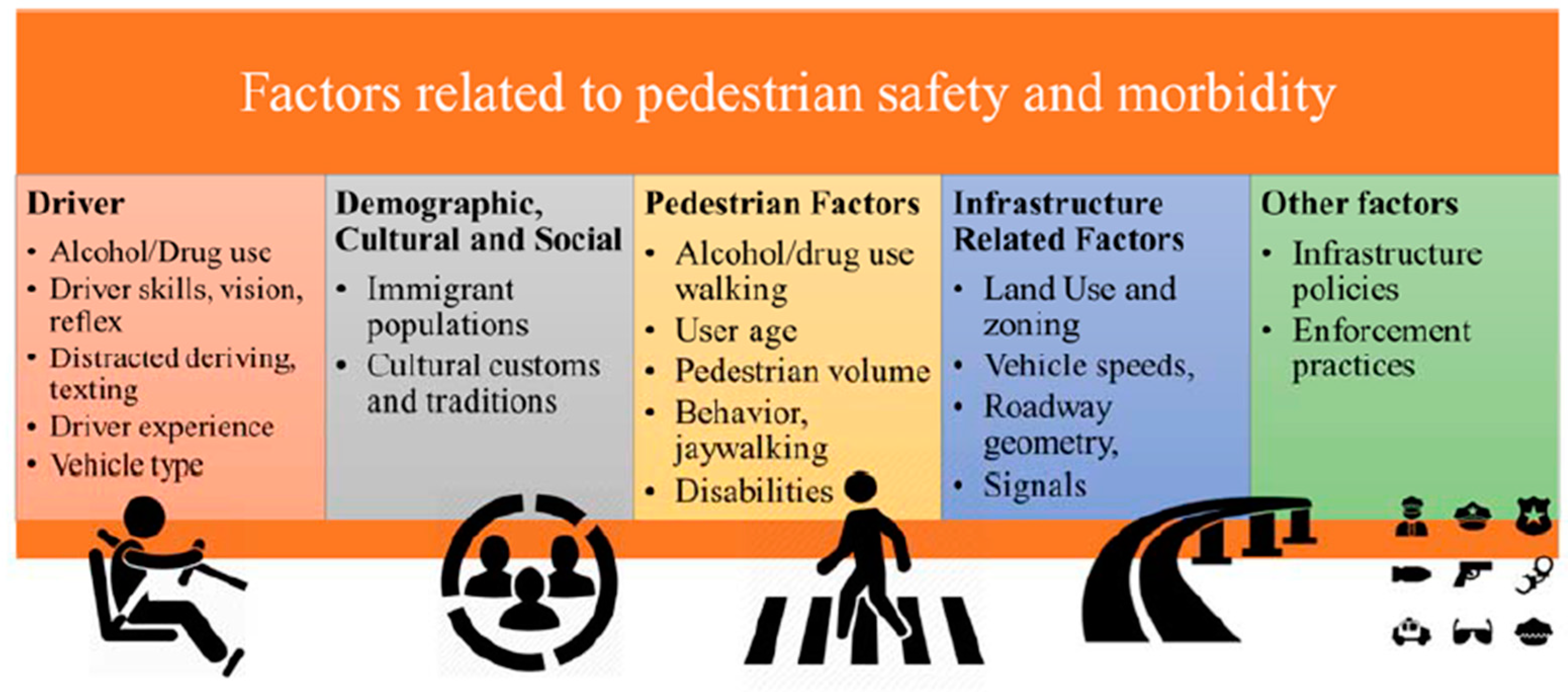
The factors that influence pedestrian-vehicle crashes can be clustered into five groups: (a) driver, (b) demographic, cultural, and social, (c) pedestrian, (d) infrastructure, and (e) policy factors [15], as shown in Figure 2. These factors that influence the safety of VRUs are related to the risk of injuries and fatalities and are explained as follows.
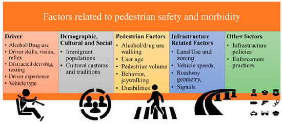
Figure 2.
Factors related to pedestrian risk safety [16].
Driver factors: Driver factors with an important influence on the occurrence and severity of pedestrian crashes are driving experience, driving skills, reflex, level of vision, and level of distractions [17].
Demographic factors: Some research studies concluded that there is a relationship between pedestrian injury rates and population demographics (e.g., Hispanic population), schooling level, socioeconomic level, and pedestrian habits. Immigrants are more prone to suffer injuries or fatalities in traffic. Therefore, transport infrastructure systems must be improved in these areas, e.g., traffic safety messages in other languages may also be installed to reduce pedestrian injuries [18].
Pedestrian factors: The way pedestrians perceive traffic safety, which is related to their level of awareness regarding crashes, influences the decision to walk or drive. Additional factors influencing this decision are the level of difficulty for crossing a street, the ease of walking on sidewalks close to motorized traffic, and the concern of crime occurrences [19]. The pedestrian factors that exert a negative influence on their own safety are the use of alcohol and/or drugs, behavioral patterns, age, jaywalking, disabilities, and risk perception [20].
Infrastructure factors: The physical configuration and condition of transport infrastructure assets have a major impact on pedestrian safety. Infrastructure factors that significantly affect VRU safety are posted speed, crossing distance, presence of medians, functional classification, intersections and crosswalks, land use and zoning, and traffic control signs.
Posted speed: A higher risk for pedestrian crashes occurs at higher posted speeds [18,21,22,23]. For instance, 86% of fatalities from 2010 to 2019 involving pedestrians and bicyclists in Washington occurred on roads with posted speed limits equal to or higher than 48.3 km/h [24]. The probability of pedestrian fatalities in an encounter with a vehicle increases from 20% to 75% when the vehicle speed increases from 48.3 to 80.5 km/h [25].
Crossing distance: The exposure of pedestrians to vehicles is associated with the perpendicular walking distance while crossing a street at intersections and midblock crossings. If there is a lack of physical barriers along a sidewalk and the street, pedestrians are also exposed to traffic. Longer crossing distances could cause more pedestrian accidents, compared to shorter distances [26].
Presence of medians: Medians reduce the risk of pedestrians’ exposure to traffic at crosswalks because median refuges shorten pedestrians’ crossing distance and provide shelter from the incoming traffic flow [27]. Lower crash risks for pedestrians occur in areas with existing medians. The frequency of pedestrian crashes is reduced at multilane road crossings, due to the presence of medians [17].
Functional classification: Pedestrian crashes are related to the functional classification of the roads. For example, in Texas, crashes involving pedestrians most frequently occur on local roads [26]. Similar findings were found in North Carolina, in which most pedestrian crashes occurred on local roads [28]. This situation is explained by the higher pedestrian exposure to crashes on local roads when compared to highways.
Intersections and crosswalks: Pedestrian crashes are more frequent to occur within 15.30 m of roadway intersections [29]. Crosswalks, whether marked or unmarked, exist at intersections to facilitate pedestrians crossing the street [27]. Areas located around marked crosswalks have more pedestrian accidents than areas far away from intersections and crosswalks [28,29,30]. For example, 70% of severe pedestrian and bicycle crashes in Texas occurred at intersections [26].
Land use and zoning: Land use and zoning allow for the identification of areas with high pedestrian concentrations (e.g., residential areas, school areas, college campuses, commercial zones), which are indicators of pedestrian exposure. The percentage of residential and commercial areas has shown a direct relationship with a high pedestrian crash occurrence [31]. Other research studies found that 95% of pedestrian injuries and 75% of fatalities take place close to urban areas [31], while urban residential-commercial areas, single-family residential areas, and neighborhood service districts have experienced a growth in pedestrian accidents [32].
Traffic control signs: The Federal Highway Administration (FHWA) considers that the type of traffic control at an intersection is a major factor in designing the intersection approach legs and crossings. Traffic flow can be controlled by control signs to improve pedestrian safety [13]. In marked crosswalks, pedestrian safety can be improved by installing pedestrian warning signs, advance yield and stop signs, flashing beacons, or pedestrian signals [29].
Policy factors: The United States Department of Transportation (USDOT) has considered VRU safety as one of its highest priorities [33]. Similarly, the National Highway Transportation Safety Administration (NHTSA), along with the FHWA, have pedestrian safety as a top priority in their public awareness programs.
The American Association of State Highway and Transportation Officials (AASHTO) has also contributed to improve pedestrian safety. State DOTs are required to develop strategic highway safety plans (SHSP) that include measures to enhance road safety for pedestrians, older drivers, bicyclists, and motorcyclists. The National Cooperative Highway Research Program (NCHRP) Report 500 contains several volumes to guide transportation agencies on how to mitigate injuries and fatalities for pedestrians and bicyclists [30,34,35].
Countermeasures are implemented by transportation agencies to decrease the frequency and severity of pedestrian crashes. The California Department of Transportation (CalTrans), the FHWA, and the Safe Transportation Research and Education Center have developed a manual with 85 countermeasures to address roadway safety risk. The countermeasures are organized in three groups: signalized intersection countermeasures (e.g., adding intersection lighting, improving signal timing), non-signalized intersection countermeasures (e.g., installing all-way stop controls, installing pedestrian crossing), and roadway countermeasures (e.g., installing guardrails, installing median barriers). Crash reduction factors are recommended for each countermeasure. The higher the factor, the greater the expected crash reduction is expected to be [36].
NHTSA has also developed guidelines to assist state highway safety offices to develop effective, evidence-based countermeasures to address areas with traffic safety problems. These pedestrian safety countermeasures include pedestrian safety zones, reduction and enforcement of speed limits, conspicuity enhancement, driving training, pedestrian gap acceptance training, and university educational campaigns [37].
2.2. Safety Indices
There are several safety indices developed by governmental associations, researchers, and transportation agencies to assess VRU safety. The Vulnerable Road User Safety Index (VRUSI) is adopted as part of the methodology. VRU expresses the need for road user safety and considers the level of comfort, traffic stress, and risk of facilities. VRUSI was developed to identify high risk safety areas for pedestrians at intersections. The higher the VRUSI, the higher the risk for pedestrians [16]. Equation (1) calculates the VRUSI.
where:
- VRUSI—Vulnerable Road User Safety Index;
- PLOC—Pedestrian Level of Comfort;
- PLTS—Pedestrian Level of Traffic Stress;
- Ped ISI—Pedestrian Intersection Safety Index.
The pedestrian level of comfort (PLOC) identifies safety needs for pedestrians on roadway segments based on roadway speed, number of lanes with sidewalks, bicycle lanes, parking, and planting buffers. PLOC ranges from 1 to 4, where 1 is assigned to the safest pedestrian facilities and 4 is assigned to the less accessible facilities [38]. Therefore, PLOC categories are defined as follows:
- PLOC 1—Suitable for almost all pedestrians, including children trained to safely cross intersections.
- PLOC 2 —Suitable for most adult pedestrians, but demanding more attention than might be expected from children.
- PLOC 3—Suitable for older children, with little or no parental supervision.
- PLOC 4—Mostly suitable for adults and children with parental supervision [16].
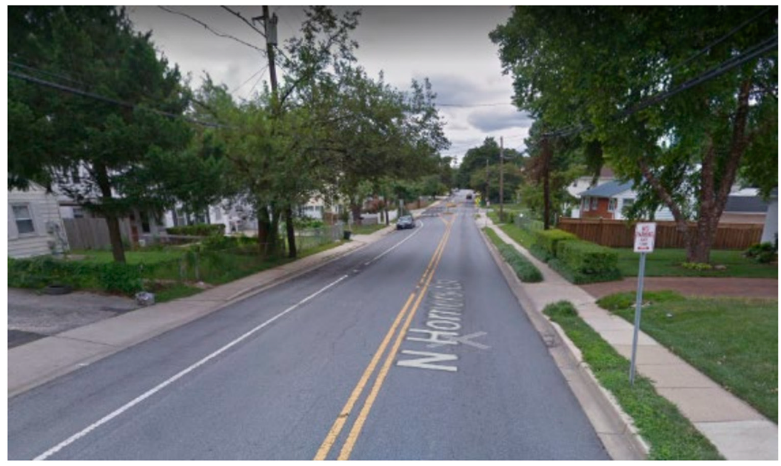
PLOC partial scores are retrieved from matrices developed by the FHWA according to the roadway conditions as a function of roadway speed, number of lanes with sidewalks, bicycle lanes, parking, and planting buffers. A PLOC scoring example is presented in a report titled, “Pedestrian Level of Comfort Methodology,” prepared by the Montgomery County Planning Department as part of the Montgomery County’s Pedestrian Plan in 2020. The example corresponds to a road segment located on 408 North Horners Lane, Rockville, MD, USA [39]. Figure 3 shows the characteristics of the roadway section and conditions to calculate PLOC, which are summarized as follows:
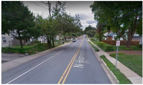
Figure 3.
Roadway Conditions of roadway section located at 408 North Horners Lane, Rockville, MD, USA [39].
- “408 North Horners Lane, Rockville
- Left: Non-urban area, primary residential, 4-foot pathway, no buffer, designated parking lane, 25 mph, good condition.
- Score: 2—Somewhat Comfortable.
- Right: Non-urban area, primary residential, 3.5-foot pathway, 2-foot buffer, no on-street separation, 25 mph, good condition.
- Score: 2—Somewhat Comfortable” [39].
The pedestrian level of traffic stress (PLTS) rates pedestrian safety when crossing a roadway based on sidewalk condition, physical buffer type, total buffering width, general land use, collector and local un-signalized intersection crossing, and arterial un-signalized intersection crossing, with or without a median refuge. PLTS methodology does not require extensive data collection, since much of the needed data is collected routinely. PLTS ranges from 1 to 4, where 1 represents the lowest traffic [40]. PLTS category definitions are as follows:
- PLTS 1—little to no traffic stress; it requires little attention to the traffic situation.
- PLTS 2—little traffic stress, but it requires more attention to the traffic situation for young children. This intersection is suitable for children over 10 years old, teens, and adults.
- PLTS 3—moderate stress, and it is suitable for adults. An able-bodied adult would feel uncomfortable, but safe using this facility.
- PLTS 4—high traffic stress [16].
PLTS partial scores are retrieved from matrices developed by the FHWA according to the roadway characteristics and evaluation criteria as a function of sidewalk condition, physical buffer type, total buffering width, general land use, collector and local un-signalized intersection crossing, and arterial un-signalized intersection crossing, with or without a median refuge. An example for a road segment located on 13th St at Chemeketa St, Salem, OR, USA, is presented in the manual titled, “Analysis Procedures Manual-Version 2,” published by the Planning Section Transportation Planning Analysis Unit of the Oregon Department of Transportation (ODOT) in 2018 [40].
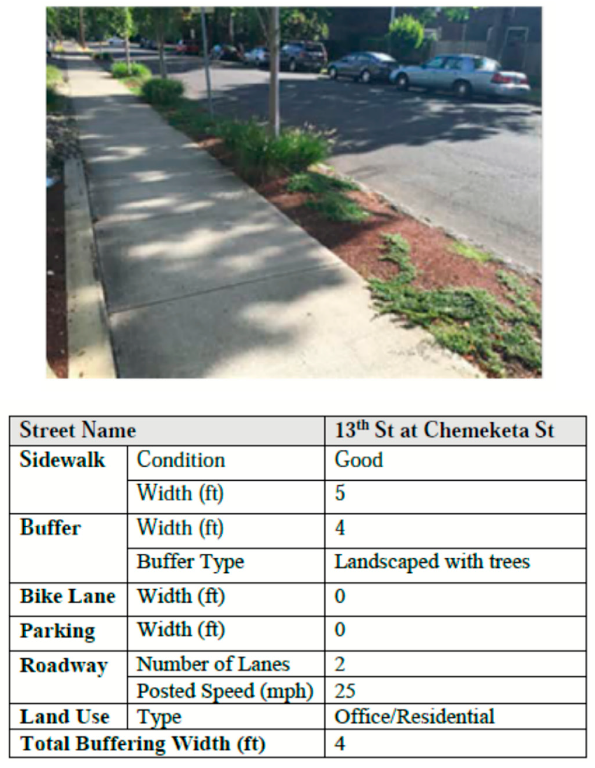
Figure 4 shows the characteristics of the roadway section to calculate individual PLTS for each evaluation criterion. For a sidewalk in good condition with a width of 5 feet, the PLTS score is 2. For a facility with trees as a buffer type and a posted speed of 25 MPH, the PLTS score is 1. For the total buffering width criterion, the PLTS score is 2, since there are two travel lanes, and the overall buffering width is less than 5 feet. For the overall land use criterion, the PLTS is 1, since the roadway section is located in a residential and office area. The individual PLTS scores for each criterion under evaluation are compared to determine the final PLTS score. For the roadway section presented in this example, the overall PLTS is 2 [40].
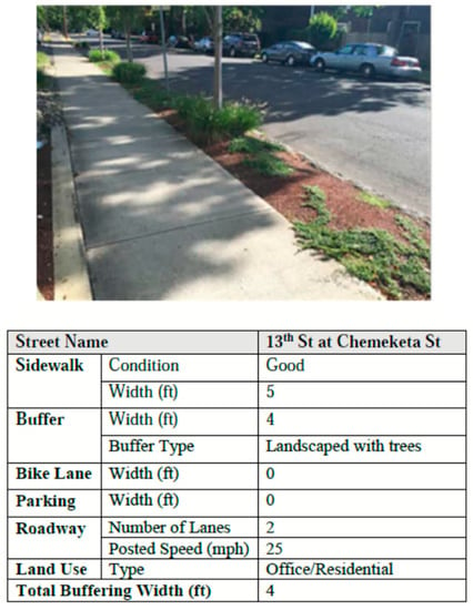
Figure 4.
Roadway conditions and Information of 13th St at Chemeketa St, Salem, OR, USA adapted from [40].
The pedestrian intersection safety index (Ped ISI) identifies intersection crossings in need of safety enhancements as related to the type of traffic control for leg of crossing, number of through vehicle lanes on the main street, 85th percentile traffic speed on the main street, average daily traffic of the main street, and predominant land use. The higher the ISI, the higher the priority for safety enhancements will be [41].
The Ped ISI model developed by the FHWA provides Equation (2) to calculate the safety index score for a single pedestrian crossing. The equation and parameters to determine Ped ISI are shown in Table 1.

Table 1.
Ped ISI model and variable descriptions [41].
The FHWA developed a Ped ISI calculator spreadsheet tool to facilitate the calculations. This tool can be downloaded from the FHWA Coordinating, Developing, and Delivering Highway Transportation Innovations website [42].
Data to calculate the PLOC, PLTS, and Ped ISI can be obtained from different sources. There are websites, such as the Roadway Characteristics Handbook (RCI) and Model Inventory of Roadway Elements (MIRE), from which the list of variables can be collected. For state highways, data are available in the state department of transportation’s databases, including the online TransGIS application. Aerial imagery and street level tools can also capture widths and presence variables, including parking and buffer widths or intersection/mid-block crossing features. Traffic volumes should be taken from existing sources, or already counted as part of the same study. Streets with similar characteristics can be used as proxy for the others, if their traffic volume is known [40].
3. Methodology to Incorporate VRU Safety Criteria into TAM
To incorporate safety criteria into the TAM decision-making process, there is a need to provide a framework that includes VRUs data and a method to prioritize project funding. The VRU-TAM framework allows for a better understanding of the data needs and overall process, while the method provides the means to facilitate the implementation.
3.1. VRU-TAM Framework Overview
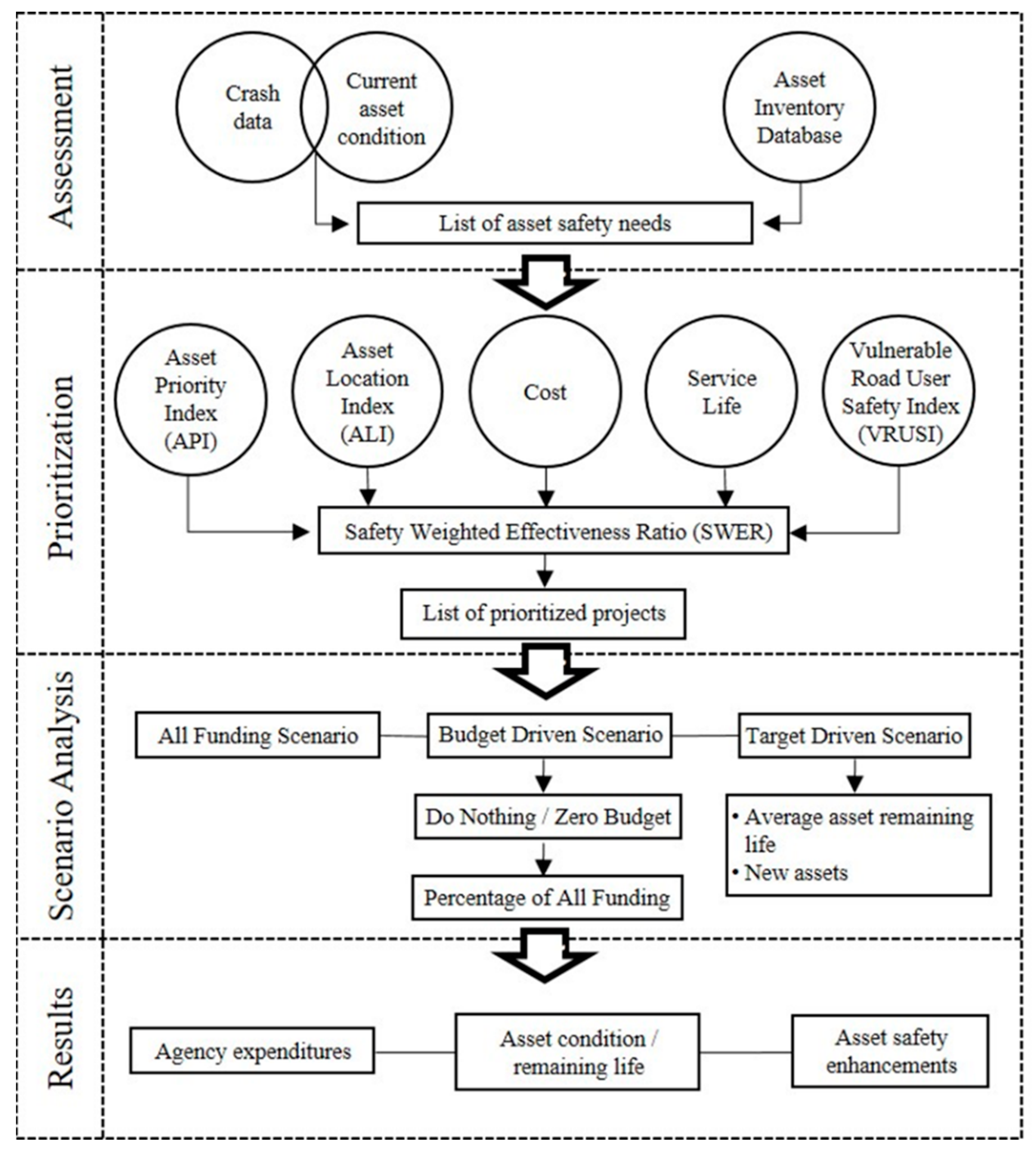
Sidewalks, bikeways, medians, pavement markings, guardrails, and road lighting all have a significant influence on traffic safety [43]. The VRU-TAM framework considers all these asset components in the decision-making process. Figure 5 shows an overview of the framework with four major phases: assessment, prioritization, scenario analysis, and results.
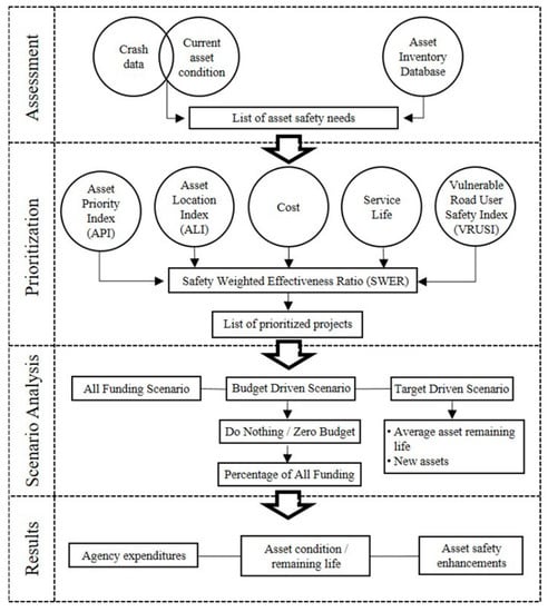
Figure 5.
Overview of the VRU-TAM framework.
In the assessment phase, safety needs, including improvements, are identified from the analysis of crash data and the asset condition registered in the inventory database. In the second phase, prioritization, the assets are ranked considering their importance, location, maintenance cost, remaining service life, and safety risk. In the last two phases, scenario analyses are conducted, and the results are reported to senior management. Scenario analyses can include two baseline scenarios: (a) all funding scenario, with an unlimited budget, and (b) do nothing scenario, with a zero budget. Then, budget-driven and target performance-driven scenarios are formulated to conduct further analysis. The budget-driven scenario considers that limited funds are available, and desired objectives are established in the target performance-driven scenario (e.g., average remaining life, percentage of implementation of new crosswalks). The results of the scenario analyses are reported for decision making in terms of agency investments, crosswalk condition, and remaining life.
The VRU-TAM framework can be applied to a single asset group of the transport infrastructure (e.g., sidewalks, medians, crosswalks) to enhance pedestrian safety, although safety considerations for enhancement should apply to an entire road segment. The VRU-TAM framework is aimed to improve the decision-making process at the strategic level by prioritizing the allocation of funds to projects that enhance pedestrian safety. The process is completed at the senior management level, and it is followed by project level individual studies of the road segments to design the safety components.
3.2. Method to Prioritize Assets Based on Pedestrian Safety
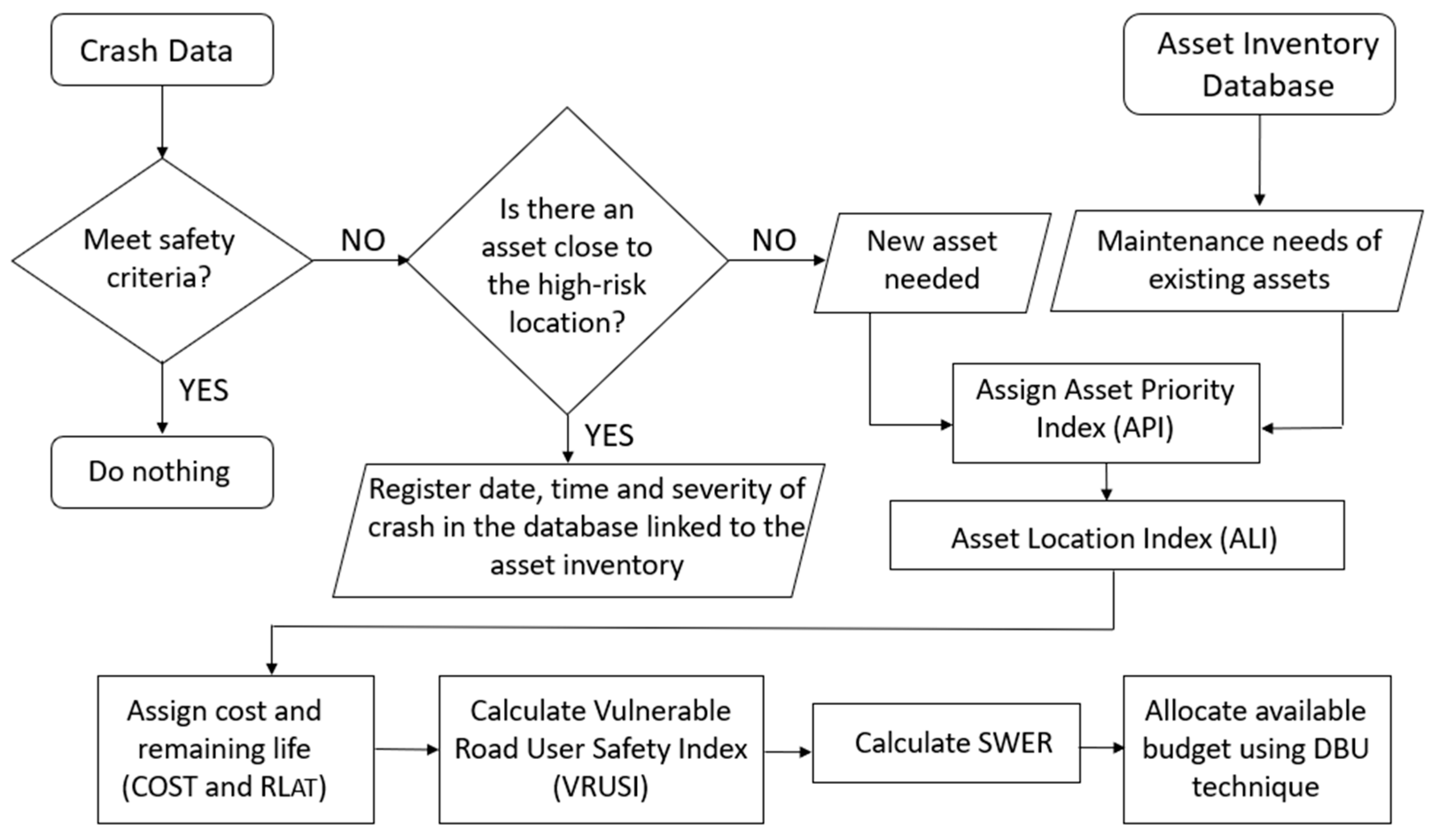
The methodology for prioritization considers the asset importance, location, maintenance cost, remaining service life, and pedestrian safety. Figure 6 shows a flowchart summarizing the steps to prioritize assets considering safety pedestrian needs.
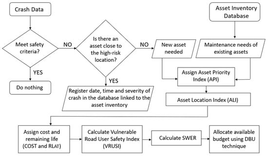
Figure 6.
Methodology to prioritize assets including VRU safety criteria.
A safety-weighted effectiveness ratio (SWER) is proposed to prioritize funding allocation. The process to calculate SWER is explained for crosswalks. Sections with two or more mid-block pedestrian crashes are candidates for safety improvements; if the crosswalk space is above 91.5 m, that section is also identified on the list of safety needs [44].
Equation (3) calculates SWER:
where:
- API—Asset Priority Index;
- ALI—Asset Location Index;
- EUAC—Equivalent Uniform Annual Cost;
- RLAT—Remaining Service Life After Treatment;
- VRUSI—Vulnerable Road User Safety Index.
A vulnerable road user safety index (VRUSI) is proposed as a metric to assess the VRU safety conditions of road infrastructure. VRUSI combines three specific indexes: (a) the pedestrian level of comfort (PLOC), (b) the pedestrian level of traffic stress (PLTS), and (c) the pedestrian intersection safety index (Ped ISI). These three indexes are calculated independently, as explained in the previous section, and VRUSI is obtained by adding the PLOC, PLTS, and Ped ISI, as shown in Equation (4).
where:
VRUSI = PLOC + PLTS + Ped ISI
- VRUSI—Vulnerable Road User Safety Index;
- PLOC—Pedestrian Level of Comfort;
- PLTS—Pedestrian Level of Traffic Stress;
- PED ISI—Pedestrian Intersection Safety Index.
An asset priority index (API) differentiates between the need for the maintenance of existing assets and the need for new safety assets in the transportation network. For instance, a new crosswalk can be assigned an API equal to 1, and existing crosswalks in need of maintenance assigned an API equal to 0.8. The location of the asset component is introduced through an asset location index (ALI). Projects with crosswalks that will benefit a large pedestrian traffic flow, for example, sections situated in the proximity of schools, hospitals, parks, transit stops, and retails, will have a higher ALI, and they can be assigned a value of 1.0, while others may be assigned a value of 0.55. The values for ALI and API depend on the agency criterion, and guidelines should be developed according to their network characteristics, agency policies, and local regulations.
Maintenance cost (COST) and remaining service life after treatment (RLAT) are involved in the calculation of SWER to address the budget aspects and effects of the treatment on the service life of the assets. The materials frequently used for crosswalks are epoxy resins, paints, thermoplastics, and inlay tapes, among others. Each material has a different cost and expected service life.
The calculation of the equivalent uniform annual cost (EUAC) is shown in Equation (5).
where:
- n—years of analysis, equals to RLAT or number of years from first analysis year to year of treatment;
- f—inflation rate (in percentage);
- COSTF—inflated costs or unit costs at the year of analysis. The future inflated costs are calculated with equation 6 where COSTP in the present unit cost at the first year of analysis.
Once SWER is calculated for each management section in the transportation network, then they are ranked from the highest to the lowest value. The dynamic bubble up (DBU) technique is used to allocate the funds, if there are budget constraints, or the performance targets established for the asset group [45]. In the DBU technique, the funding allocation process begins at the top of the asset list ranked by SWER from the highest to the lowest; if there are enough funds to address the safety needs for that section, then funds are allocated, and the section that follows in the ranked list “bubbles up” for budget allocation. This budget allocation process continues until the total available budget is exhausted, or the performance objective is met.
4. Data for Scenario Analysis
To illustrate the applicability of the methodology, scenario analyses were conducted for a mockup transportation network segment, with 10 sections. Table 2 shows the data that include section ID, average daily traffic (ADT), number of crashes, and the block lengths. The section ID is defined by the agency in the street inventory database, ADT can be obtained from traffic studies, the number of crashes can be retrieved from a transportation injury mapping system (TIMS), and block lengths can be recorded from field surveys or estimated, as a preliminary analysis, based on Google Earth measurements. It is observed that the block lengths or distance between legal opportunities to cross were above 300 ft for most of the sections, which is the recommended threshold for crosswalks. Section 9-C-N was the only exception, with a block length of 230 ft. The API, ALI, VRUSI, and SWER are shown for each section.

Table 2.
Crosswalk data for scenario analyses.
Six base-line maintenance scenarios are analyzed in this example:
- Scenario 1—All funding baseline scenario. All funds are allocated to address the budget needs for new crosswalks and their maintenance. The need for new crosswalks is identified for sections with existing crosswalk characteristics above the desired crosswalk spacing, which is set up to 300 ft. Maintenance of crosswalk markings is scheduled every 3 years.
- Scenario 2—Do nothing baseline scenario. No funds are allocated to the crosswalks in the sections.
- Scenario 3—available budget is 85% of the total 10-year budget needs.
- Scenario 4—available budget is 70% of the total 10-year budget needs.
- Scenario 5—available budget is 50% of the total 10-year budget needs.
- Scenario 6—available budget is 35% of the total 10-year budget needs.
5. Results and Discussion
Table 3 shows the results of a 10-year analysis for the base-line maintenance scenarios 1 and 2 in terms of cost of new crosswalks, maintenance costs, average remaining life, and percentage of improved crosswalks. In this example, the unit cost estimate for crosswalk paint is USD 340, with an expected service life of 3 years [46,47]. Note that cost, maintenance frequency, and expected service life data should be established by each agency.

Table 3.
All Funding and Do Nothing Scenario Results for Crosswalks.
In Scenario 1, all funding, the total estimated budget of USD 21,280 was spent over a 10-year period. Construction of new crosswalks and maintenance of existing crosswalks were funded; the average remaining life ranges were between 1.7 and 2.4 years.
In Scenario 2, do nothing, none of the segments received funding over the entire analysis period, and all existing crosswalks reached the end of their expected lives in 2022.
Table 4 shows a summary of the effects of limited funding on the crosswalks’ remaining life and backlog costs. The critical year and the backlog costs estimates at the end of 2030 are also reported. Backlog refers to assets that did not receive maintenance or were not replaced when needed.

Table 4.
Budget-Driven Scenario Results for Crosswalks.
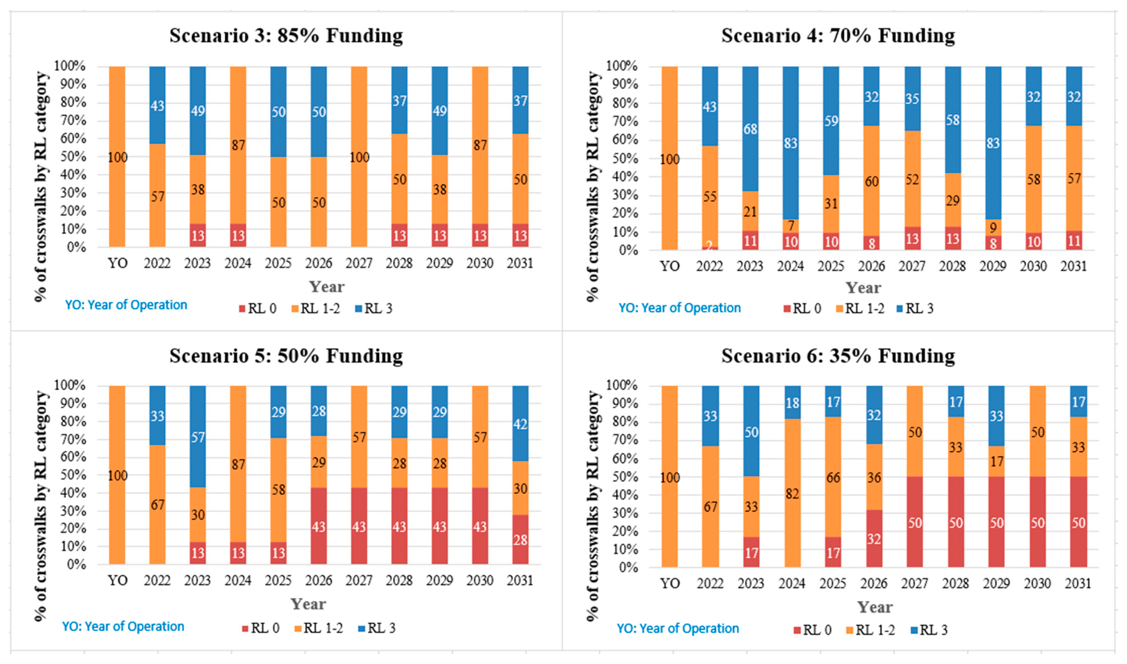
Figure 7 illustrates the consequences of limited funding on the crosswalk’s remaining life. In the budget-driven scenarios, the remaining life of all the crosswalks is between 1 and 2 years at the beginning of the analysis, or year of operation (YO). In the budget-driven scenario 3 (85% of funding), up to 13% of crosswalks have no remaining life, and only 83% of new crosswalks are implemented. In scenario 4 (70% of funding), up to 13% of crosswalks have no remaining life, and only 67% of new crosswalks are implemented. With more limited budgets in scenarios 5 and 6 (50% and 35% of funding), up to 43% and 50% of crosswalks, respectively, have no remaining life, and only 50% and 33% of new crosswalks, respectively, are funded.
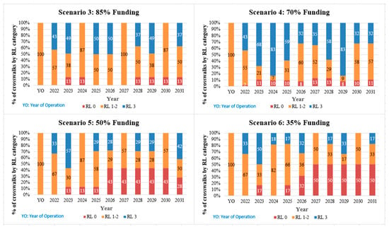
Figure 7.
Crosswalks remaining life over time for budget-driven scenarios.
6. Conclusions
Safety is a major concern for transportation agencies, and pedestrians are the most vulnerable road users. The major contribution of this paper is the development of a vulnerable road user-transportation asset management (VRU-TAM) framework to incorporate safety criteria in the decision-making process at the strategic level. The framework consists of four major phases:
- Assessment—To identify safety improvements based on crash data and the condition of the assets in the inventory database.
- Prioritization—To rank projects using the safety-weighted effectiveness ratio (SWER), in combination with the dynamic bubble up technique (DBU), for budget allocation.
- Scenario Analysis—To evaluate the effects of budget-driven and target-performance driven scenarios.
- Results—The summary of agency expenditures, maintenance costs, and remaining service life.
The example for pedestrians and crosswalks demonstrated the applicability of the prioritization approach in the TAM decision-making process. The approach considers the importance, location, safety risk, maintenance cost, and asset remaining life. The results of the budget-driven scenarios, using an approach that includes safety criteria, provide broader insights about the consequences of limited budgets in backlog costs and the remaining life of infrastructure assets. In the example, it is found that in the “all funding” scenario (Scenario 1), without budget constraints, the crosswalk network condition is preserved and the annual remaining life averages are between 1.7–2. However, crosswalks would reach the end of their expected lives in the first year in the “do nothing” scenario (Scenario 2), if no budget is allocated to address the safety needs. The effect of reduced budgets on safety criteria is observed in the results obtained for scenarios 3, 4, 5, and 6 (85%, 70%, 50% and 35% of funding respectively). For example, the budget-driven scenario results for 85% of funding (Scenario 3) show 13% of the crosswalks with zero remaining life at the end of 10 years, and with 35% of funding, the percentage of crosswalks with zero remaining life increases to 50% in year 1 (Scenario 6). It is also observed that the backlog cost increases significantly with reduced budgets. Backlog cost increases about 4.5 times with 35% of funding (Scenario 6) when compared to backlog costs with 85% of funding (Scenario 3).
The VRU-TAM framework enhances the traditional TAM decision-making process that typically hinges only upon the physical condition of asset. This approach will assist transportation agencies in identifying locations at high risk for pedestrians to prioritize budget allocation considering safety criteria. Safety standards should not be compromised by reduced budgets, and reaching goals established by DOTs in programs such as Vision Zero must be always a priority. With safety criteria and tangible metrics explicitly incorporated into the funding allocation process at the strategic and operational management levels, the VRU-TAM framework developed in this research aims to have a positive direct impact on pedestrian safety. Well-maintained safe pedestrian infrastructure has two main advantages: (a) it encourages more people to walk and bike, and (b) it reduces pedestrian crashes and fatalities.
Future research could focus on attempting to quantify the benefits in terms of reduction in pedestrian crashes. More specifically, a data-driven analysis to estimate the return on investment (ROI) or the benefit-cost (B/C) ratio of adopting this framework could also be conducted as an extension of this research.
Author Contributions
C.M.C.: conceptualization, manuscript writing, analysis, and discussion of results (corresponding author); M.V.: conceptualization, manuscript writing, literature search, analysis; S.L.M.: literature review, resources, editing, and review. All authors have read and agreed to the published version of the manuscript.
Funding
This work was supported by the Metropolitan Transportation Commission (MTC) in the San Francisco Bay Area, California, U.S. Project Title: Streetsaver® Training and Guidance: Asset and Pavement Management Systems Research Development and Implementation.
Institutional Review Board Statement
Not applicable.
Informed Consent Statement
Not applicable.
Data Availability Statement
All data generated or analyzed during this study are included in the published article.
Acknowledgments
The authors acknowledge work conducted for the Metropolitan Transportation Commission (MTC) in the San Francisco Bay Area, CA, USA.
Conflicts of Interest
The authors declare no conflict of interest.
References
- World Health Organization (WHO). Summary. In Global Status Report on Road Safety; WHO: Geneva, Switzerland, 2018. [Google Scholar]
- Barnes, S.C. Car Accident Trends and Statistics for 2022. 2022. Available online: https://www.hooverrogers.com/posts/car-accident-statistics-2022 (accessed on 29 May 2022).
- United States Department of Transportation USDOT. Policy Priorities-Roadway (2015) Fatalities. 2017. Available online: https://www.transportation.gov/transition/policy-priorities (accessed on 29 May 2022.).
- U.S. Department of Transportation. Moving Ahead for Progress in the 21st Century Act (MAP-21); U.S. Department of Transportation: Washington, DC, USA, 2015.
- U.S. Department of Transportation. Fixing America’s Surface Transportation Act or "FAST Act"; U.S. Department of Transportation: Washington, DC, USA, 2022.
- National Safety Council (NSC). Road to Zero: A Plan to Eliminate Roadway Deaths; NCS: Itasca, IL, USA, 2022. [Google Scholar]
- Toward Zero Deaths. The National Strategy Vision is a Highway System Free of Fatalities. 2022. Available online: https://www.towardzerodeaths.org/ (accessed on 29 May 2022).
- Vision Zero Network. What is Vision Zero? 2022. Available online: https://visionzeronetwork.org/about/what-is-vision-zero/ (accessed on 29 May 2022).
- Insurance Institute for Highway Safety (IIHS). Fatality Facts 2020 Pedestrians. 2022. Available online: https://www.iihs.org/topics/fatality-statistics/detail/pedestrians (accessed on 29 May 2022).
- Governors Highway Safety Association (GHSA). New Projection: U.S. Pedestrian Deaths Jumped in First Half of 2021; GHSA: Washington, DC, USA, 2022. [Google Scholar]
- U.S. Department of Transportation. Safe Streets and Roads for All (SS4A) Grant Program; U.S. Department of Transportation: Washington, DC, USA, 2022.
- Infrastructure Investment & Jobs Act. Analysis & Timeline of ARTBA Leadership on the Road to Reauthorization; American Road & Transportation Builders Association: Washington, DC, USA, 2021.
- Federal Highway Administration (FHWA). Asset Management Overview; United States Department of Transportation (USDOT): Washington, DC, USA, 2007.
- Governors Highway Safety Association GHSA. Pedestrian Traffic Fatalities by State. 2020 Preliminary Data; GHSA: Washington, DC, USA, 2021. [Google Scholar]
- Heinonen, J.A.; Eck, J.E. Pedestrian Injuries and Fatalities, Problem Oriented Guides for Police Problem-Specific Guides Series, Guide No. 51; Office of Community Oriented Policing Services, U.S. Department of Justice: Washington, DC, USA, 2007.
- Chang, C.M.; Rodriguez, E. Vulnerable Road User Safety Enhancements for Transportation Asset Management. In Center for Transportation, Environment, and Community Health (CTECH). Final Report; U.S. Department of Transportation: Washington, DC, USA, 2019. [Google Scholar]
- Roundsari, B.; Mock, C.; Kaufman, R.; Grossman, D.; Henary, B.; Crandall, J. Pedestrian crashes: Higher injury severity and mortality rate for light truck vehicles compared with passenger vehicles. Inj. Prev. 2004, 10, 154–158. [Google Scholar] [CrossRef] [PubMed] [Green Version]
- Zegeer, Z.; Sandt, L.; Scully, M.; Ronkin, M.; Cynecki, M.; Lagerwey, P.; Chaney, H.; Schroeder, B.; Snyder, E. How to Develop a Pedestrian Safety Action Plan; National Highway Traffic Safety Administration (NHTSA): Washington, DC, USA, 2009.
- Park, N.; Deakin, E.; Lee, J.S. Perception-Based Walkability Index to Test Impact of Microlevel Walkability on Sustainable Mode Choice Decisions. In Transportation Research Record: Journal of the Transportation Research Board; No. 2464; Transportation Research Board of the National Academies: Washington, DC, USA, 2014. [Google Scholar]
- Texas Department of Transportation (TxDOT). Texas Motor Vehicle Crash Statistics-2017. In Crash Contributing Factors; TxDOT: Austin, TX, USA, 2017. [Google Scholar]
- Lee, C.; Hellinga, B.; Saccomanno, F. Evaluation of variable speed limits to improve traffic safety. Transp. Res. Part C Emerg. Technol. 2006, 14, 213–228. [Google Scholar] [CrossRef]
- Garder, P.E. The impact of speed and other variables on pedestrian safety in Maine. Accid. Anal. Prev. 2004, 36, 533–542. [Google Scholar] [CrossRef]
- Sandt, L.; Thomas, L.; Langford, K.; Nabors, D. A Resident’s Guide for Creating Safer Communities for Walking and Biking; Federal Highway Administration (FHWA): Washington, DC, USA, 2015.
- Washington State Department of Transportation (WSDOT). People Power WSDOT on the Move to Improve Active Transportation. In Gray Notebook: Quarterly Performance Analysis of WSDOT’s Multimodal Systems and Programs; WSDOT: Washington, DC, USA, 2020. [Google Scholar]
- Groeger, L. Unsafe at Many Speeds. Article Retrieved from ProPublica. 2016. Available online: https://www.propublica.org/article/unsafe-at-many-speeds (accessed on 29 May 2022).
- Fitzpatrick, K.; Brewer, M.; Avelar, R. Driver Yielding at Traffic Control Signals, Pedestrian Hybrid Beacons, and Rectangular Rapid-Flashing Beacons in Texas. Transp. Res. Rec. J. Transp. Res. Board 2014, 2463, 46–54. [Google Scholar] [CrossRef]
- Palamara, P.; Broughton, M. An Investigation of Pedestrian Crashes at Traffic Intersections in the Perth Central Business District; Curtin-Monash Accident Research Center, Faculty of Health Sciences Curtin University: Bentley, Australia, 2012. [Google Scholar]
- North Carolina Department of Transportation (NCDOT). North Carolina Pedestrian and Bicycle Crash Data Tool; University of North Carolina Highway Safety Research Center (HSRC): Chapel Hill, NC, USA, 2018.
- City of San Francisco, Better Streets Plan, 2010. In Policies and Guidelines for the Pedestrian Realm; City of San Francisco: San Francisco, CA, USA, 2018.
- National Cooperative Highway Research Program NCHRP. A Guide for Reducing Collisions Involving Bicycles. In Guidance for Implementation of the AASHTO Strategic Highway Safety Plan; Transportation Research Board: Washington, DC, USA, 2008; Volume 18. [Google Scholar]
- Senserrick, T.; Boufous, S.; Rome, L.; Ivers, R.; Stevenson, M. Detailed Analysis of Pedestrian Casualty Collisions in Victoria, Australia. J. Traffic Inj. Prev. 2014, 15 (Suppl. S1), S197–S205. [Google Scholar] [CrossRef] [PubMed]
- Loukaitou-Sideris, A.; Liggett, R.; Sung, H. Death on the Crosswalk: A Study of Pedestrian-Automobile Collisions in Los Angeles. J. Plan. Educ. Res. 2007, 26, 338–351. [Google Scholar] [CrossRef]
- United States Department of Transportation (USDOT). Summary Report. In Pedestrian and Bicyclist Road Safety Assessments; USDOT: Washington, DC, USA, 2015. [Google Scholar]
- National Cooperative Highway Research Program NCHRP. A Guide for Reducing Collisions Involving Older Drivers. In Guidance for Implementation of the AASHTO Strategic Highway Safety Plan; Transportation Research Board: Washington, DC, USA, 2004; Volume 9. [Google Scholar]
- National Cooperative Highway Research Program NCHRP. A Guide for Reducing Collisions Involving Pedestrians. In Guidance for Implementation of the AASHTO Strategic Highway Safety Plan; Transportation Research Board: Washington, DC, USA, 2004; Volume 10. [Google Scholar]
- California Department of Transportation (CALTRANS); Federal Highway Association (FHWA); Safe Transportation Research and Education Center (SafeTREC). Local Roadway Safety-Version 1.6. Manual for California’s Local Road Owners. CALTRANS; 2022. Available online: https://dot.ca.gov/-/media/dot-media/programs/local-assistance/documents/hsip/2022/lrsm2022.pdf (accessed on 29 May 2022).
- National Highway Traffic Safety Administration (NHTSA). Traffic Safety Facts 2015, Data: Pedestrians; National Highway Traffic Safety Administration: Washington, DC, USA, 2017.
- City of Encinitas. Active Transportation Plan. In Administrative Draft; City of Encinitas: Encinitas, CA, USA, 2018. [Google Scholar]
- Montgomery County Planning Department. Montgomery County’s Pedestrian Plan; Pedestrian Level of Comfort Methodology. 2020. Available online: https://montgomeryplanning.org/planning/transportation/pedestrian-planning/pedestrian-master-plan/ (accessed on 29 May 2022).
- Oregon Department of Transportation (ODOT). Planning Section Transportation Planning Analysis Unit. Analysis Procedures Manual; Version 2; Transportation Development Division: Salem, OR, USA, 2018.
- Federal Highway Administration (FHWA), Pedestrian and Bicyclist Intersection Safety Indices; United States Department of Transportation: Washington, DC, USA, 2007.
- Federal Highway Administration (FHWA), Coordinating, Developing and Delivering Highway Transportation Innovations. Available online: https://www.fhwa.dot.gov/publications/research/safety/pedbike/pedisi.cfm (accessed on 29 May 2022).
- Chang, C.M.; Vavrova, M. Vulnerable User Road Safety Enhancements for Transportation Asset Management; American Society of Civil Engineers (ASCE): Reston, VA, USA, 2016. [Google Scholar]
- Virginia Department of Transportation (VDOT). Guidelines for the installation of Marked Crosswalks; FHWA/VTRC 05-R18; Federal Highway Association: Harrisburg, PA, USA, 2004.
- Chang, C. Development of a Multi-Objective Strategic Management Approach to Improve Decisions for Pavement Management Practices in Local Agencies. Dissertation; Texas A&M University: College Station, TX, USA, 2007. [Google Scholar]
- Federal Highway Administration (FHWA). Status of the Nation’s Highways, Bridges, and Transit: Conditions & Performance; United States Department of Transportation: Washington, DC, USA, 2013.
- Federal Highway Administration (FHWA). Performance Based Planning and Programming Guidebook; United States Department of Transportation: Washington, DC, USA, 2013.
Publisher’s Note: MDPI stays neutral with regard to jurisdictional claims in published maps and institutional affiliations. |
© 2022 by the authors. Licensee MDPI, Basel, Switzerland. This article is an open access article distributed under the terms and conditions of the Creative Commons Attribution (CC BY) license (https://creativecommons.org/licenses/by/4.0/).

