
Suburbanization within City Limits in Hungary—A Challenge for Environmental and Social Sustainability


Abstract
:1. Introduction
- To explore the prevalence of suburbanization within city limits and suburbanization directed to separated inner areas and outskirts in Hungary;
- To draw a detailed picture of the demographic and land-use change processes in four cities selected as case studies (Győr, Zalaegerszeg, Kecskemét, Szeged);
- To explore the micro-level differences between the destination areas of suburbanization within city limits, to draw attention to the diverse social and environmental impacts of the process and highlight the arising sustainability challenges.
2. Materials and Methods
2.1. Methodology
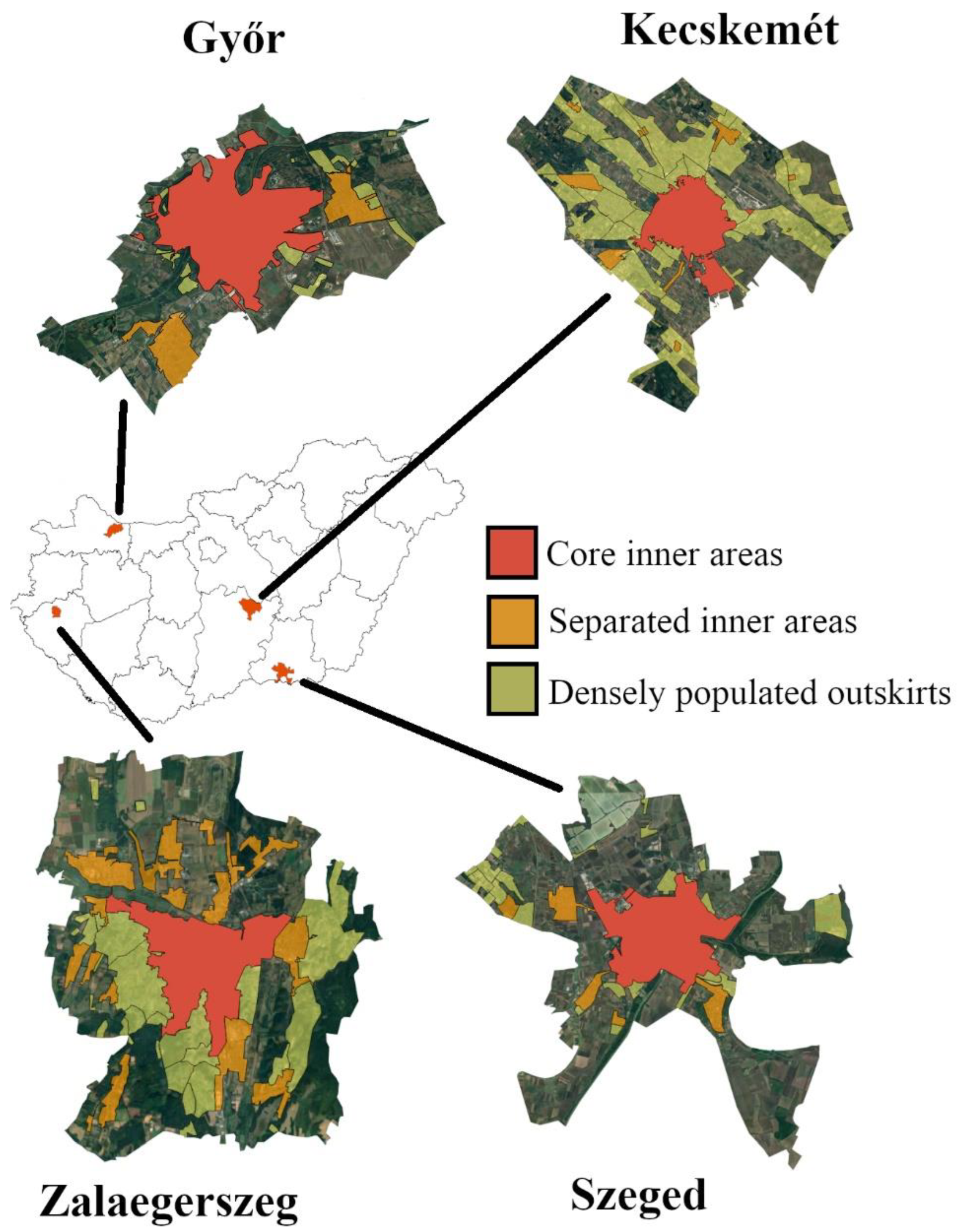
- Core inner areas;
- Separated inner areas;
- Densely populated outskirts;
- Sparsely populated outskirts.
2.2. Study Area
3. Results
3.1. Suburbanization within City Limits as Population Redistribution
- Core inner areas—2872 people per km2;
- Separated inner areas—1260 people per km2;
- Densely populated outskirts—150 people per km2;
- Sparsely populated outskirts—7 people per km2.
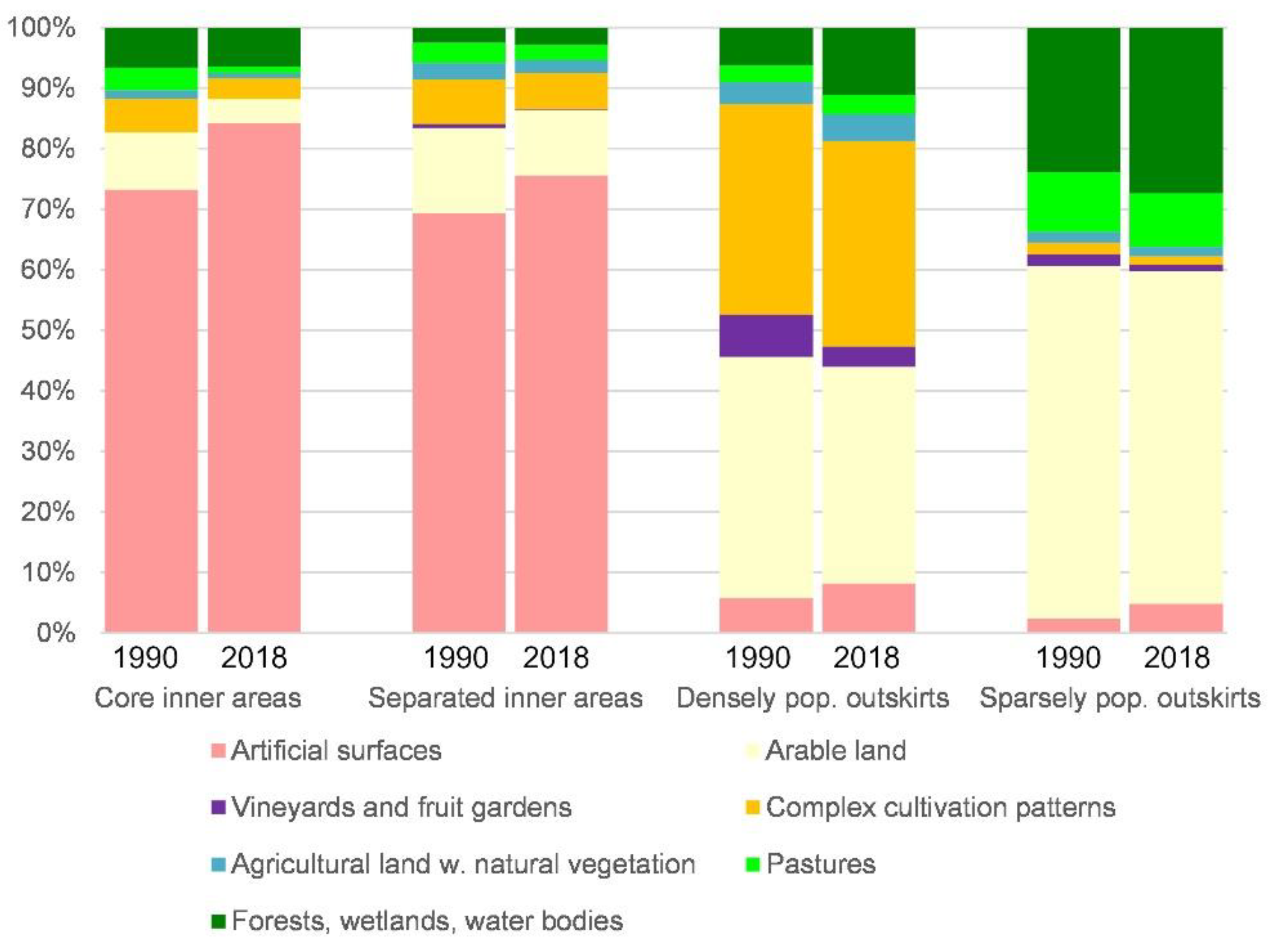
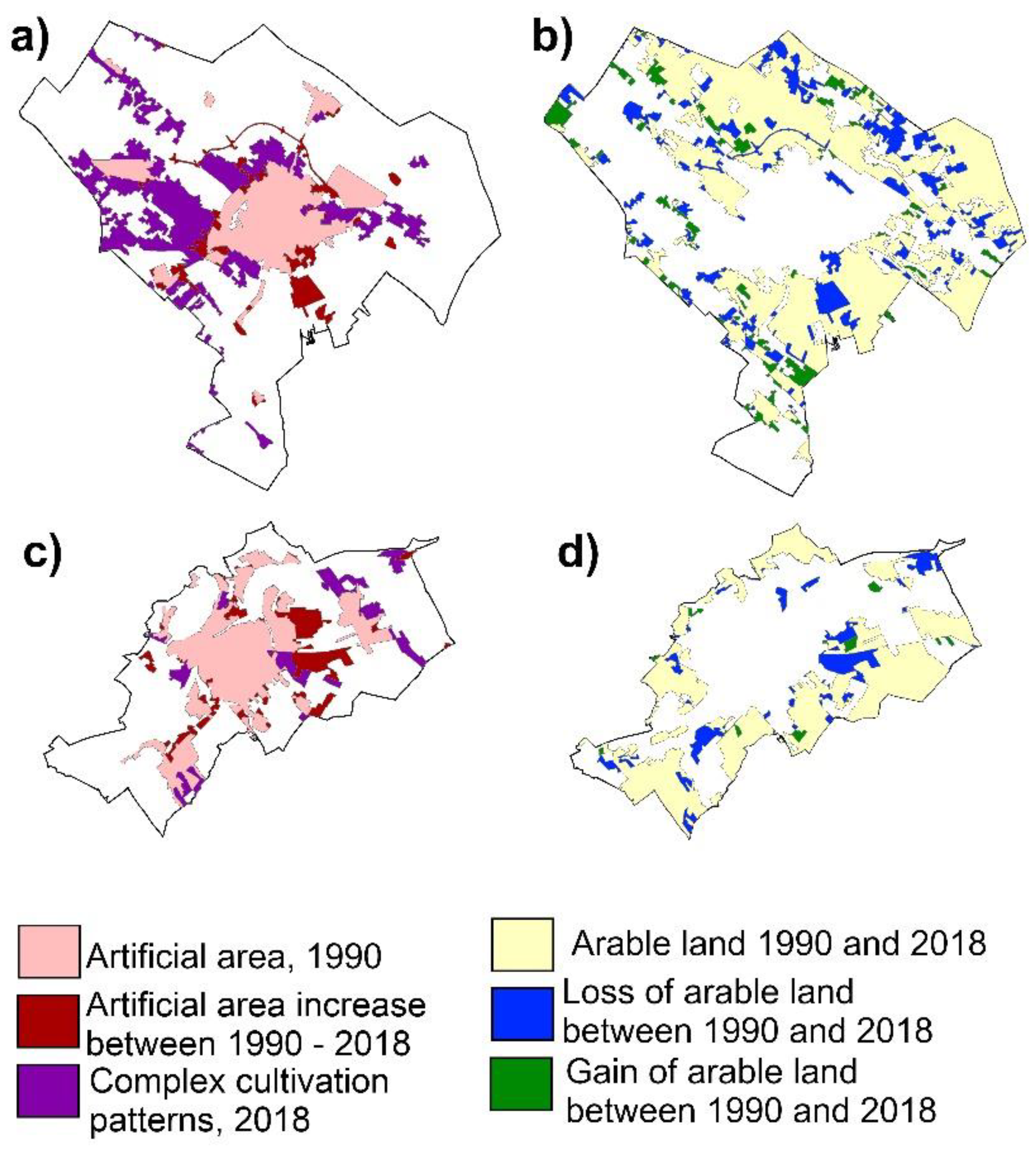
3.2. Suburbanization within City Limits as the Driver of Land Cover Transition
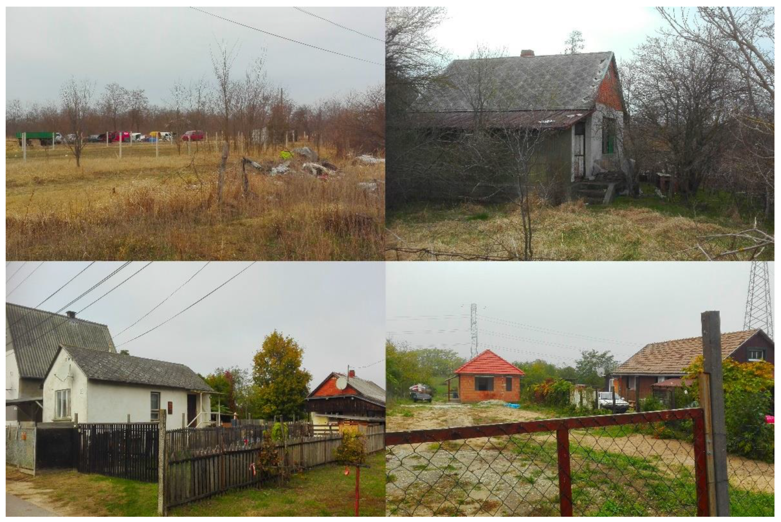
3.3. Suburbanization within City Limits as a Social and Environmental Sustainability Challenge
4. Discussion
5. Conclusions
Author Contributions
Funding
Institutional Review Board Statement
Informed Consent Statement
Data Availability Statement
Conflicts of Interest
Appendix A

| Total Area (Hectares) | Artificial Surfaces, Hectares | Arable Land, Hectares | Vineyards and Fruit Gardens, Hectares | Pastures, Hectares | Complex Cultivation Patterns, Hectares | Agricultural Land with Natural Vegetation, Hectares | Forests, Semi-Natural Areas, Wetlands, Hectares | ||||||||
|---|---|---|---|---|---|---|---|---|---|---|---|---|---|---|---|
| Corine Land Cover categories | CLC 1.1.1–1.4.2 | CLC 2.1.1, 2.1.3 | CLC 2.2.1, 2.2.2. | CLC 2.3.1 | CLC 2.4.2 | CLC 2.4.3 | CLC 3.1.1–4.1.2 | ||||||||
| Year | 1990 | 2018 | 1990 | 2018 | 1990 | 2018 | 1990 | 2018 | 1990 | 2018 | 1990 | 2018 | 1990 | 2018 | |
| Győr, core inner areas | 4396.95 | 2750.81 | 3379.73 | 374.48 | 100.64 | 0.00 | 0.00 | 346.27 | 108.47 | 193.97 | 136.20 | 42.42 | 16.15 | 594.11 | 566.91 |
| Győr, separated inner areas | 1299.18 | 878.49 | 951.58 | 233.94 | 170.98 | 24.72 | 0.00 | 5.95 | 14.08 | 137.87 | 156.65 | 16.47 | 4.14 | 1.75 | 1.76 |
| Győr, densely populated outskirts | 771.13 | 136.46 | 221.40 | 50.69 | 31.76 | 124.32 | 0.03 | 9.35 | 5.56 | 375.37 | 454.67 | 51.21 | 34.75 | 23.02 | 22.81 |
| Győr, sparsely populated outskirts | 10,989.84 | 380.83 | 620.06 | 6502.18 | 5903.89 | 182.39 | 147.47 | 934.47 | 854.05 | 125.54 | 207.07 | 203.66 | 217.54 | 2456.44 | 2838.67 |
| Zalaegerszeg, core inner areas | 1151.10 | 1002.86 | 1036.44 | 31.89 | 29.59 | 0.00 | 0.00 | 55.16 | 38.64 | 54.59 | 40.16 | 1.01 | 0.68 | 5.58 | 5.58 |
| Zalaegerszeg, separated inner areas | 1229.43 | 680.39 | 799.19 | 246.09 | 218.21 | 0.00 | 0.19 | 76.56 | 46.20 | 80.21 | 35.99 | 87.13 | 55.71 | 22.17 | 22.07 |
| Zalaegerszeg, densely populated outskirts | 1891.94 | 93.53 | 100.16 | 215.70 | 217.22 | 11.31 | 0.00 | 4.45 | 4.00 | 1099.39 | 1144.63 | 228.90 | 156.50 | 238.63 | 269.40 |
| Zalaegerszeg, sparsely populated outskirts | 5973.93 | 70.15 | 491.71 | 2407.50 | 2110.82 | 2.48 | 92.37 | 1178.77 | 935.88 | 90.68 | 77.90 | 241.00 | 231.75 | 1977.59 | 2019.26 |
| Kecskemét, core inner areas | 3441.05 | 2388.75 | 2894.03 | 670.35 | 329.97 | 0.00 | 0.00 | 43.20 | 0.39 | 280.91 | 148.38 | 12.16 | 22.59 | 1.25 | 1.26 |
| Kecskemét, separated inner areas | 896.01 | 678.04 | 757.62 | 83.46 | 38.44 | 5.84 | 2.31 | 60.96 | 48.05 | 67.07 | 43.15 | 0.00 | 5.20 | 0.63 | 1.23 |
| Kecskemét, densely populated outskirts | 12,512.16 | 238.18 | 543.91 | 5677.84 | 5074.02 | 1072.57 | 582.93 | 377.45 | 480.86 | 4109.72 | 3783.37 | 305.28 | 523.27 | 731.08 | 1523.77 |
| Kecskemét, sparsely populated outskirts | 15,418.23 | 452.25 | 611.27 | 8577.29 | 8017.83 | 838.29 | 293.70 | 1358.83 | 1519.78 | 592.57 | 337.17 | 229.98 | 189.93 | 3368.91 | 4448.43 |
| Szeged, core inner areas | 4002.71 | 3370.08 | 3629.79 | 149.36 | 53.36 | 0.00 | 0.00 | 30.71 | 0.00 | 192.65 | 121.32 | 125.88 | 68.71 | 21.23 | 16.74 |
| Szeged, separated inner areas | 1073.11 | 882.97 | 888.51 | 67.32 | 60.48 | 0.00 | 0.00 | 6.91 | 5.48 | 43.88 | 36.69 | 19.03 | 28.94 | 31.47 | 31.48 |
| Szeged, densely populated outs. | 2074.09 | 517.73 | 546.92 | 930.99 | 840.86 | 0.00 | 0.51 | 97.52 | 64.51 | 407.16 | 466.67 | 32.78 | 49.48 | 74.65 | 91.87 |
| Szeged, sparsely populated outskirts | 20,948.94 | 327.55 | 853.17 | 13,615.11 | 13,234.35 | 0.00 | 25.20 | 1743.14 | 1421.75 | 206.88 | 138.83 | 272.76 | 198.41 | 2597.00 | 2939.47 |
References
- Konecka-Szydłowska, B.; Trócsányi, A.; Pirisi, G. Urbanisation in a formal way? The different characteristics of the ‘newest towns’ in Poland and Hungary. Reg. Stat. 2019, 8, 135–153. [Google Scholar] [CrossRef]
- Kovács, Z.; Farkas, Z.J.; Egedy, T.; Kondor, A.C.; Szabó, B.; Lennert, J.; Baka, D.; Kohán, B. Urban sprawl and land conversion in post-socialist cities: The case of metropolitan Budapest. Cities 2019, 92, 71–81. [Google Scholar] [CrossRef]
- Kubeš, J. European post-socialist cities and their near hinterland in intra-urban geography literature. Bull. Geogr. Socio-Econ. Ser. 2013, 19, 19–43. [Google Scholar] [CrossRef] [Green Version]
- Nuissl, H.; Rink, D. The ‘production’ of urban sprawl in eastern Germany as a phenomenon of post-socialist transformation. Cities 2005, 22, 123–134. [Google Scholar] [CrossRef]
- Nikodemus, O.; Bell, S.; Grīne, I.; Liepiņš, I. The impact of economic, social and political factors on the landscape structure of the Vidzeme Uplands in Latvia. Landsc. Urban Plan. 2005, 70, 57–67. [Google Scholar] [CrossRef]
- Sýkora, L.; Bouzarovski, S. Multiple Transformations: Conceptualising the Post-communist Urban Transition. Urban Stud. 2011, 49, 43–60. [Google Scholar] [CrossRef] [Green Version]
- Schafft, K. A network approach to understanding post-socialist rural inequality in the 1990′s. East. Eur. Countrys. 2000, 6, 25–40. [Google Scholar]
- Brade, I.; Herfert, G.; Wiest, K. Recent trends and future prospects of socio-spatial differentiation in urban regions of Central and Eastern Europe: A lull before the storm? Cities 2009, 26, 233–244. [Google Scholar] [CrossRef]
- Kok, H. Migration from the city to the countryside in Hungary and Poland. GeoJournal 1999, 49, 53–62. [Google Scholar] [CrossRef]
- Ott, T. From Concentration to De-concentration—Migration Patterns in the Post-socialist City. Cities 2001, 18, 403–412. [Google Scholar] [CrossRef]
- Sýkora, L.; Ouředníček, M. Sprawling postcommunist metropolis: Commercial and residential suburbanization in Prague, Brno, the Czech Republic. In Employment Deconcentration in European Metropolitan Areas; Razin, E., Ed.; Springer: Dordrecht, Germany, 2007; pp. 209–233. [Google Scholar]
- Timár, J. The main features of suburbanization in the Great Hungarian Plain. Landsc. Urban Plan. 1992, 22, 177–187. [Google Scholar] [CrossRef]
- Tammaru, T. Suburban Growth and Suburbanisation under Central Planning: The Case of Soviet Estonia. Urban Stud. 2001, 38, 1341–1357. [Google Scholar] [CrossRef]
- Hornby, W.F.; Jones, M. An Introduction to Settlement Geography; Cambridge University Press: Cambridge, UK, 1990; p. 151. [Google Scholar]
- Szmytkie, R.; Krzysztofik, R. The processes of incorporation and secession of urban and suburban municipalities: The case of Poland. Nor. Geogr. Tidsskr. Nor. J. Geogr. 2019, 73, 110–127. [Google Scholar] [CrossRef]
- Sykora, L.; Cermak, Z. City growth and migration patterns in the context of ‘communist’ and ‘transitory’ periods in Prague’s urban development / Croissance urbaine et modèles migratoires à Prague au temps du communisme et dans la période de transition. Espace Popul. Sociétés 1998, 16, 405–416. [Google Scholar] [CrossRef]
- Slaev, A.D.; Nedović-Budić, Z.; Krunić, N.; Petrić, J.; Daskalova, D. Suburbanization and sprawl in post-socialist Belgrade and Sofia. Eur. Plan. Stud. 2018, 26, 1389–1412. [Google Scholar] [CrossRef]
- Bajmócy, P.; Makra, Z. Központi-, egyéb belterületek és külterületek népesedési trendjei Magyarországon 1960–2011 között. Településföldrajzi Tanulmányok 2016, 2, 3–21. [Google Scholar]
- Csatári, B.; Farkas, J.Z.; Lennert, J. Land use changes in the rural-urban fringe of Kecskemét after the economic transition. J. Settl. Spat. Plan. 2013, 2, 153–159. [Google Scholar]
- Pócsi, G. Land Use Change of the ‘Small Hobby Gardens’ in the Peri-Urban Area of Szeged, Hungary. Forum Geogr. 2011, 10, 312–321. [Google Scholar] [CrossRef]
- Spórna, T. The suburbanisation process in a depopulation context in the Katowice conurbation, Poland. Environ. Socio-Econ. Stud. 2018, 6, 57–72. [Google Scholar] [CrossRef] [Green Version]
- Wysocka, D.; Biegańska, J.; Grzelak-Kostulska, E. Construction Activity as an Element of Suburban Zone Development. Land 2021, 10, 1229. [Google Scholar] [CrossRef]
- Hardi, T.; Repaská, G.; Veselovský, J.; Vilinová, K. Environmental consequences of the urban sprawl in the suburban zone of Nitra: An analysis based on landcover data. Geogr. Pannonica 2020, 24, 205–220. [Google Scholar] [CrossRef]
- Hlaváček, P.; Kopáček, M.; Horáčková, L. Impact of Suburbanisation on Sustainable Development of Settlements in Suburban Spaces: Smart and New Solutions. Sustainability 2019, 11, 7182. [Google Scholar] [CrossRef] [Green Version]
- Ira, V. The changing intra-urban structure of the Bratislava city and its perception. Geogr. Časopis 2003, 55, 91–108. [Google Scholar]
- Gagyi, Á.; Vigvary, A. Informal Practices in Housing Financialisation: The Transformation of an Allotment Garden in Hungary. Crit. Hous. Anal. 2018, 5, 46–55. [Google Scholar] [CrossRef]
- Kovács, A.D.; Farkas, J.Z. Problems and Development Concepts for Scattered Farms in Hungary—A Case Study from the ”Kiskunság Region”. Hrvat. Geogr. Glas. Geogr. Bull. 2012, 73, 165–177. [Google Scholar] [CrossRef] [Green Version]
- Adamiak, C. Cottage sprawl: Spatial development of second homes in Bory Tucholskie, Poland. Landsc. Urban Plan. 2016, 147, 96–106. [Google Scholar] [CrossRef]
- Petrovic, F. Changes of the landscape with dispersed settlement. Ekol. Bratisl. 2006, 1, 201–211. [Google Scholar]
- Szmytkie, R. Suburbanisation processes within and outside the city: The development of intra-urban suburbs in Wrocław, Poland. Morav. Geogr. Rep. 2021, 29, 149–165. [Google Scholar] [CrossRef]
- Ianos, I.; Zamfir, D.; Stoica, V.; Cercleux, L.; Schvab, A.; Pascariu, G. Municipal solid waste management for sustainable development of Bucharest metropolitan area. Environ. Eng. Manag. J. 2012, 11, 359–369. [Google Scholar] [CrossRef]
- Theobald, D.M. Landscape Patterns of Exurban Growth in the USA from 1980 to 2020. Ecol. Soc. 2005, 10, 32–66. Available online: http://www.jstor.org/stable/26267722 (accessed on 31 March 2022). [CrossRef] [Green Version]
- Thebo, A.L.; Drechsel, P.; Lambin, E.F. Global assessment of urban and peri-urban agriculture: Irrigated and rainfed croplands. Environ. Res. Lett. 2014, 9, 114002. [Google Scholar] [CrossRef]
- Preda, M.; Vijulie, I.; Lequeux-Dincă, A.-I.; Jurchescu, M.; Mareci, A.; Preda, A. How Do the New Residential Areas in Bucharest Satisfy Population Demands, and Where Do They Fall Short? Land 2022, 11, 855. [Google Scholar] [CrossRef]
- Korwel-Lejkowska, B. Suburban Morphology Dynamics: The Case of the Tricity Agglomeration, Poland. Sustainability 2021, 13, 12223. [Google Scholar] [CrossRef]
- Costello, L. Going Bush: The implications of urban-rural migration. Geogr. Res. 2007, 45, 85–94. [Google Scholar] [CrossRef]
- Balogh, A.; Csapó, T. Manors and scattered farms: Special settlement forms of outskirt areas in Hungary. Revijja Za Geogr. 2013, 2, 81–94. [Google Scholar]
- Freire, S.; Halkia, M.; Pesaresi, M. GHS Population Grid, Derived from EUROSTAT Census Data (2011) and ESM R2016; European Commission, Joint Research Centre (JRC) [Dataset] 2016. Available online: http://data.europa.eu/89h/jrc-ghsl-ghs_pop_eurostat_europe_r2016a (accessed on 31 March 2022).
- Vasárus, G.; Bajmócy, P.; Lennert, J. In the shadow of the city: Demographic processes and emerging conflicts in the rural-urban fringe of the Hungarian agglomerations. Geogr. Pannonica 2018, 22, 14–29. [Google Scholar] [CrossRef] [Green Version]
- Király, G.; Czirfusz, M.; Koós, B.; Tagai, G.; Uzzoli, A. Population projection for Hungary and its relation with climate change. Eur. XXI 2017, 32, 5–19. [Google Scholar] [CrossRef] [Green Version]
- Lennert, J. A magyar vidék demográfiai jövőképe 2051-ig, különös tekintettel a klímaváltozás szerepére a belső vándormozgalom alakításában. Területi Stat. 2019, 59, 498–525. [Google Scholar] [CrossRef]
- Brown, D.L.; Schafft, K.A. Population deconcentration in Hungary during the post-socialist transformation. J. Rural Stud. 2002, 18, 233–244. [Google Scholar] [CrossRef]
- Timár, J.; Váradi, M.M. The Uneven Development of Suburbanization during Transition in Hungary. Eur. Urban Reg. Stud. 2001, 8, 349–360. [Google Scholar] [CrossRef] [Green Version]
- Nagy, G.; Hegedűs, T. Urban sprawl or/and suburbanisation? The case of Zalaegerszeg. Belvedere Merid. 2016, 28, 106–119. [Google Scholar] [CrossRef]
- Von Thünen, J.H. Isolated State an English Edition of Die isolierte Staat in Beziehung auf Landwirtshaft und Nationalökonomie; Pergamon Press: New York, NY, USA, 1966; p. 304. [Google Scholar]
- Opitz, I.; Berges, R.; Piorr, A.; Krikser, T. Contributing to food security in urban areas: Differences between urban agriculture and peri-urban agriculture in the Global North. Agric. Hum. Values 2016, 33, 341–358. [Google Scholar] [CrossRef] [Green Version]
- Rüschhoff, J.; Hubatsch, C.; Priess, J.; Scholten, T.; Egli, L. Potentials and perspectives of food self-sufficiency in urban areas—a case study from Leipzig. Renew. Agric. Food Syst. 2021, 37, 227–236. [Google Scholar] [CrossRef]
- Lucertini, G.; Di Giustino, G. Urban and Peri-Urban Agriculture as a Tool for Food Security and Climate Change Mitigation and Adaptation: The Case of Mestre. Sustainability 2021, 13, 5999. [Google Scholar] [CrossRef]
- Csurgó, B.; Kovách, I.; Megyesi, B. After a Long March: The Results of Two Decades of Rural Restructuring in Hungary. East. Eur. Countrys. 2018, 24, 81–109. [Google Scholar] [CrossRef] [Green Version]
- Weaver, D.B.; Lawton, L.J. Resident Perceptions in the Urban–Rural Fringe. Ann. Tour. Res. 2001, 28, 439–458. [Google Scholar] [CrossRef]
- Źróbek-Różańska, A.; Zadworny, D. Can urban sprawl lead to urban people governing rural areas? Evidence from the Dywity Commune, Poland. Cities 2016, 59, 57–65. [Google Scholar] [CrossRef]
- Yue, W.; Liu, Y.; Fan, P. Measuring urban sprawl and its drivers in large Chinese cities: The case of Hangzhou. Land Use Policy 2013, 31, 358–370. [Google Scholar] [CrossRef]
- Antrop, M. Landscape change and the urbanization process in Europe. Landsc. Urban Plan. 2004, 67, 9–26. [Google Scholar] [CrossRef]
- Kantsa, A.; Tscheulin, T.; Junker, R.R.; Petanidou, T.; Kokkini, S. Urban biodiversity hotspots wait to get discovered: The example of the city of Ioannina, NW Greece. Landsc. Urban Plan. 2013, 120, 129–137. [Google Scholar] [CrossRef]
- Cubino, J.P.; Subirós, J.V.; Lozano, C.B. Propagule pressure from invasive plant species in gardens in low-density suburban areas of the Costa Brava (Spain). Urban For. Urban Green. 2015, 14, 941–951. [Google Scholar] [CrossRef]
- Banaszak-Cibicka, W.; Dylewski, L. Species and functional diversity—A better understanding of the impact of urbanization on bee communities. Sci. Total Environ. 2021, 774, 145729. [Google Scholar] [CrossRef]
- Ferrini, F.; Fini, A.; Mori, J.; Gori, A. Role of Vegetation as a Mitigating Factor in the Urban Context. Sustainability 2020, 12, 4247. [Google Scholar] [CrossRef]
- Thoidou, E. Spatial Planning and Climate Adaptation: Challenges of Land Protection in a Peri-Urban Area of the Mediterranean City of Thessaloniki. Sustainability 2021, 13, 4456. [Google Scholar] [CrossRef]
- Bhat, P.A.; ul Shafiq, M.; Mir, A.A.; Ahmed, P. Urban sprawl and its impact on landuse/land cover dynamics of Dehradun City, India. Int. J. Sustain. Built Environ. 2017, 6, 513–521. [Google Scholar] [CrossRef]
- Dekolo, S.; Oduwaye, L.; Nwokoro, I. Urban Sprawl and Loss of Agricultural Land in Peri-urban Areas of Lagos. Reg. Stat. 2015, 5, 20–33. [Google Scholar] [CrossRef] [Green Version]
- Gavrilidis, A.A.; Niță, M.R.; Onose, D.A.; Badiu, D.L.; Năstase, I.I. Methodological framework for urban sprawl control through sustainable planning of urban green infrastructure. Ecol. Indic. 2019, 96, 67–78. [Google Scholar] [CrossRef]
- Pramanik, S.; Punia, M.; Yu, H.; Chakraborty, S. Is dense or sprawl growth more prone to heat-related health risks? Spatial regression-based study in Delhi, India. Sustain. Cities Soc. 2022, 81, 103808. [Google Scholar] [CrossRef]
- O’Connor, J.; Brown, A. A qualitative study of ‘fear’ as a regulator of children’s independent physical activity in the suburbs. Health Place 2013, 24, 157–164. [Google Scholar] [CrossRef]
- Shucksmith, M.; Watkins, L. Housebuilding on farmland: The distributional effects in rural areas. J. Rural Stud. 1991, 7, 153–168. [Google Scholar] [CrossRef]
- Gray, D. Economic approaches to the rural. In Interpreting Rurality: Multidisciplinary Approaches; Bosworth, G., Somerville, P., Eds.; Routledge: Abingdon, UK, 2014; pp. 32–53. [Google Scholar]
- Sharp, J.S.; Clark, J.K. Between the Country and the Concrete: Rediscovering the Rural–Urban Fringe. City Community 2008, 7, 61–79. [Google Scholar] [CrossRef]
- Li, G.; Cao, Y.; He, Z.; He, J.; Cao, Y.; Wang, J.; Fang, X. Understanding the Diversity of Urban–Rural Fringe Development in a Fast Urbanizing Region of China. Remote Sens. 2021, 13, 2373. [Google Scholar] [CrossRef]
- Smith, A.; Timár, J. Uneven transformations: Space, economy and society 20 years after the collapse of state socialism. Eur. Urban Reg. Stud. 2010, 17, 115–125. [Google Scholar] [CrossRef]
- Pacione, M. Private profit, public interest and land use planning—A conflict interpretation of residential development pressure in Glasgow’s rural–urban fringe. Land Use Policy 2013, 32, 61–77. [Google Scholar] [CrossRef]
- Egedy, T. Strategic and socio-economic implications of urban regeneration in Hungary. In Development of the Settlement Network in the Central European Countries: Past, Present, and Future; Csapó, T., Balogh, A., Eds.; Springer: Berlin, Germany, 2012; pp. 146–160. [Google Scholar]
- Holm, A.; Marcińczak, S.; Ogrodowczyk, A. New-build gentrification in the post-socialist city: Łódź and Leipzig two decades after socialism. Geografie 2015, 120, 164–187. [Google Scholar] [CrossRef]
- Spórna, T.; Krzysztofik, R. ‘Inner’ suburbanisation—Background of the phenomenon in a polycentric, post-socialist and post-industrial region. Example from the Katowice conurbation, Poland. Cities 2020, 104, 102789. [Google Scholar] [CrossRef]
- Kubeš, J.; Nováček, A. Suburbs around the Czech provincial city of České Budějovice—Territorial arrangement and problems. Hung. Geogr. Bull. 2019, 68, 65–78. [Google Scholar] [CrossRef] [Green Version]
- Ouředníček, M. Differential suburban development in the prague urban region. Geogr. Ann. Ser. B Hum. Geogr. 2007, 89, 111–126. [Google Scholar] [CrossRef]
- Ren, Y.; Yan, J.; Wei, X.; Wang, Y.; Yang, Y.; Hua, L.; Xiong, Y.; Niu, X.; Song, X. Effects of rapid urban sprawl on urban forest carbon stocks: Integrating remotely sensed, GIS and forest inventory data. J. Environ. Manag. 2012, 113, 447–455. [Google Scholar] [CrossRef]
- Kabai, R. The Importance of National Landscape Character Survey in Landscape Protection. Acta Univ. Sapientiae Agric. Environ. 2011, 62, 67. [Google Scholar]
- Tosics, I.; Gerőházi, É. Győr. How to Compete with Capital Cities; European Investment Bank: Kirchberg, Luxembourg, 2019; Volume 7, pp. 1–24. [Google Scholar] [CrossRef]
- Mitchell, C.J. Creative destruction or creative enhancement? Understanding the transformation of rural spaces. J. Rural Stud. 2013, 32, 375–387. [Google Scholar] [CrossRef]
- Williamson, T.; Imbroscio, D.; Alperovitz, G. The Challenge of Urban Sprawl. In Cities and Society; Kleniewsk, N., Ed.; Blackwell Publishing Ltd.: Hoboken, NJ, USA, 2005; pp. 303–329. [Google Scholar] [CrossRef]
- Hoyk, E. Environmental condition of Kecskemét from the point of view of the climate change. Gradus 2020, 7, 121–125. [Google Scholar] [CrossRef]
- Unger, J. Heat island intensity with different meteorological conditions in a medium-sized town: Szeged, Hungary. Theor. Appl. Climatol. 1996, 54, 147–151. [Google Scholar] [CrossRef]
- Bianchini, L.; Salvia, R.; Quaranta, G.; Egidi, G.; Salvati, L.; Marucci, A. Forest Transition and Metropolitan Transformations in Developed Countries: Interpreting Apparent and Latent Dynamics with Local Regression Models. Land 2021, 11, 12. [Google Scholar] [CrossRef]
- Fisher, B.; Turner, R.K.; Morling, P. Defining and classifying ecosystem services for decision making. Ecol. Econ. 2009, 68, 643–653. [Google Scholar] [CrossRef] [Green Version]
- Hirt, S.; Stanilov, K. Informal Urban Development and Sprawl. In Twenty Years of Transition: The Evolution of Urban Planning in Eastern Europe and the Former Soviet Union, 1989–2009; Hirt, S., Stanilov, K., Eds.; UN Human Settlements Programme: Nairobi, Kenya, 2009; pp. 82–96. [Google Scholar]
- Akçalı, E.; Korkut, U. Urban transformation in Istanbul and Budapest: Neoliberal governmentality in the EU’s semi-periphery and its limits. Politi-Geogr. 2015, 46, 76–88. [Google Scholar] [CrossRef]
- Chelcea, L.; Druţǎ, O. Zombie socialism and the rise of neoliberalism in post-socialist Central and Eastern Europe. Eurasian Geogr. Econ. 2016, 57, 521–544. [Google Scholar] [CrossRef]
- Pozoukidou, G.; Ntriankos, I. Measuring and assessing urban sprawl: A proposed indicator system for the city of Thessaloniki, Greece. Remote Sens. Appl. Soc. Environ. 2017, 8, 30–40. [Google Scholar] [CrossRef]
- Bodor, A.; Varjú, V.; Grünhut, Z. The Effect of Trust on the Various Dimensions of Climate Change Attitudes. Sustainability 2020, 12, 10200. [Google Scholar] [CrossRef]
- Szafrańska, E.; de Lille, L.C.; Kazimierczak, J. Urban shrinkage and housing in a post-socialist city: Relationship between the demographic evolution and housing development in Łódź, Poland. Neth. J. Hous. Built Environ. 2018, 34, 441–464. [Google Scholar] [CrossRef] [Green Version]


| Spatial Distribution | Population Growth (pers.) 1990–2011 | Within Central Cities (%) | Administratively Independent Suburban Settlements (%) | |||
|---|---|---|---|---|---|---|
| OUT | SIA | Village Core | OUT | SIA | ||
| All agglomerations in Hungary | 484,745 | 9.0 | 9.2 | 66.4 | 8.5 | 6.9 |
| Agglomeration of Budapest | 296,412 | 1.3 | 0.3 | 80.1 | 12.0 | 6.2 |
| Agglomerations other than Budapest | 188,333 | 21.0 | 23.1 | 44.9 | 3.0 | 8.0 |
| Case City | Core Inner Areas | Separated Inner Areas | Densely Pop. Outskirts | Sparsely Pop. Outskirts |
|---|---|---|---|---|
| Győr | 106,981 | 18,349 | 1316 | 785 |
| Zalaegerszeg | 43,737 | 10,403 | 2942 | 859 |
| Kecskemét | 80,755 | 11,325 | 15,893 | 514 |
| Szeged | 141,620 | 16,600 | 5702 | 1541 |
Publisher’s Note: MDPI stays neutral with regard to jurisdictional claims in published maps and institutional affiliations. |
© 2022 by the authors. Licensee MDPI, Basel, Switzerland. This article is an open access article distributed under the terms and conditions of the Creative Commons Attribution (CC BY) license (https://creativecommons.org/licenses/by/4.0/).
Share and Cite
Vasárus, G.L.; Lennert, J. Suburbanization within City Limits in Hungary—A Challenge for Environmental and Social Sustainability. Sustainability 2022, 14, 8855. https://doi.org/10.3390/su14148855
Vasárus GL, Lennert J. Suburbanization within City Limits in Hungary—A Challenge for Environmental and Social Sustainability. Sustainability. 2022; 14(14):8855. https://doi.org/10.3390/su14148855
Chicago/Turabian StyleVasárus, Gábor László, and József Lennert. 2022. "Suburbanization within City Limits in Hungary—A Challenge for Environmental and Social Sustainability" Sustainability 14, no. 14: 8855. https://doi.org/10.3390/su14148855
APA StyleVasárus, G. L., & Lennert, J. (2022). Suburbanization within City Limits in Hungary—A Challenge for Environmental and Social Sustainability. Sustainability, 14(14), 8855. https://doi.org/10.3390/su14148855