Spatio-Temporal Dynamic of the Land Use/Cover Change and Scenario Simulation in the Southeast Coastal Shelterbelt System Construction Project Region of China
Abstract
:1. Introduction
- Can the shelterbelt construction project successfully complete its goals according to the development trends of the third phase of the NCSSCP?
- What is the most suitable land resource management and planning strategy for the southeastern coastal area?
2. Study and Data Sources
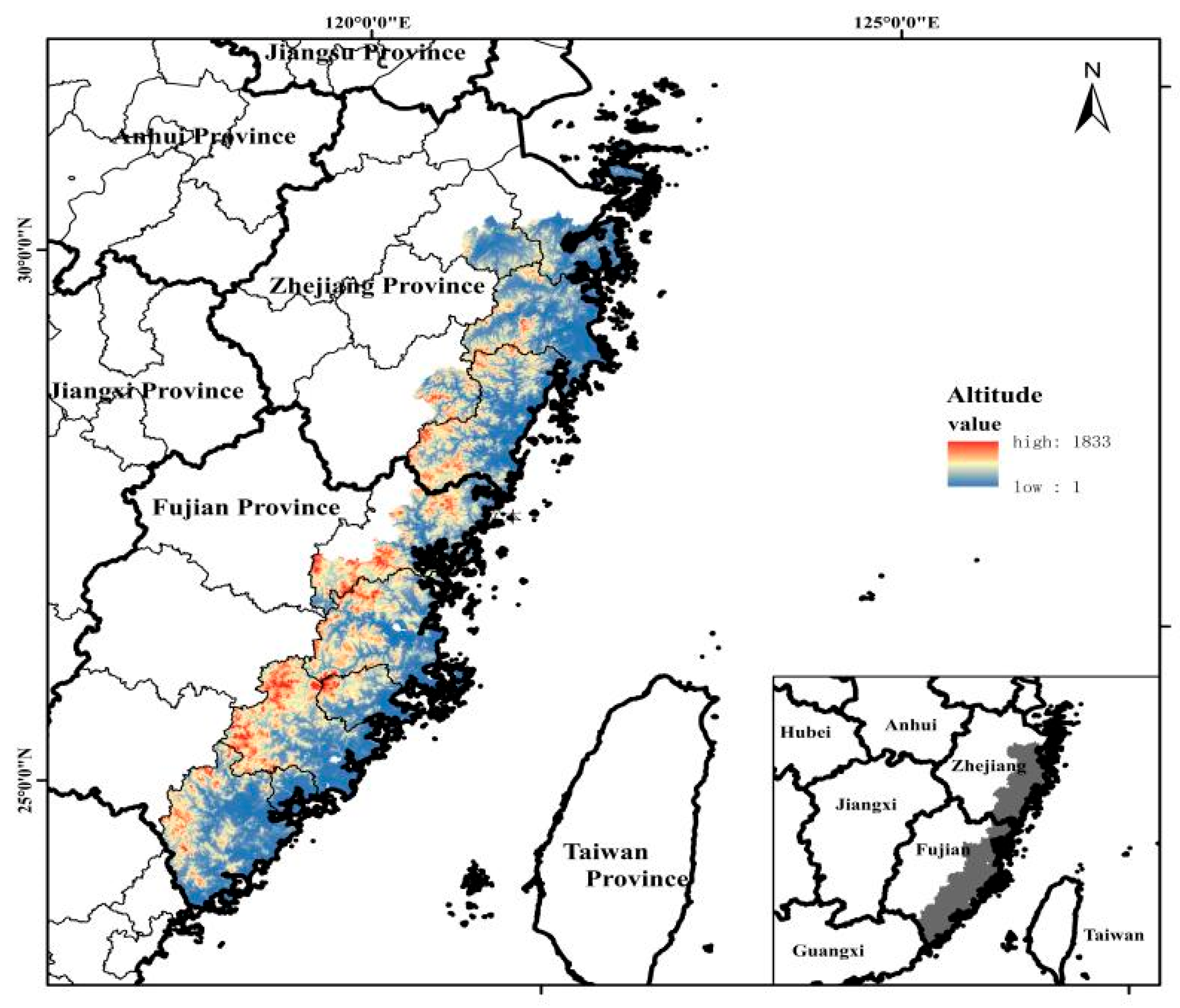
2.1. Study Area
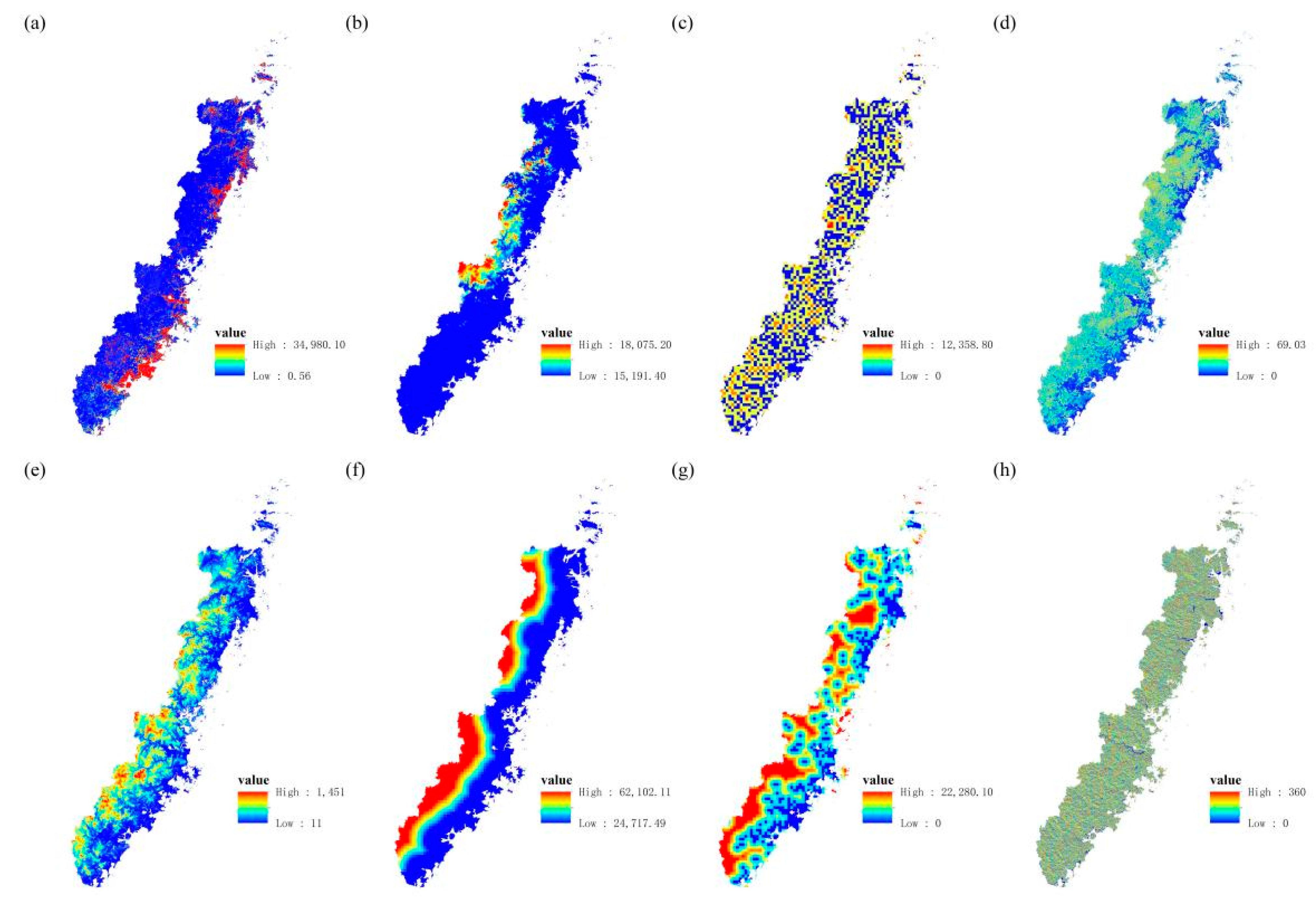
2.2. Data Resources
3. Methodology
3.1. Landscape Pattern Index
3.2. Markov Model
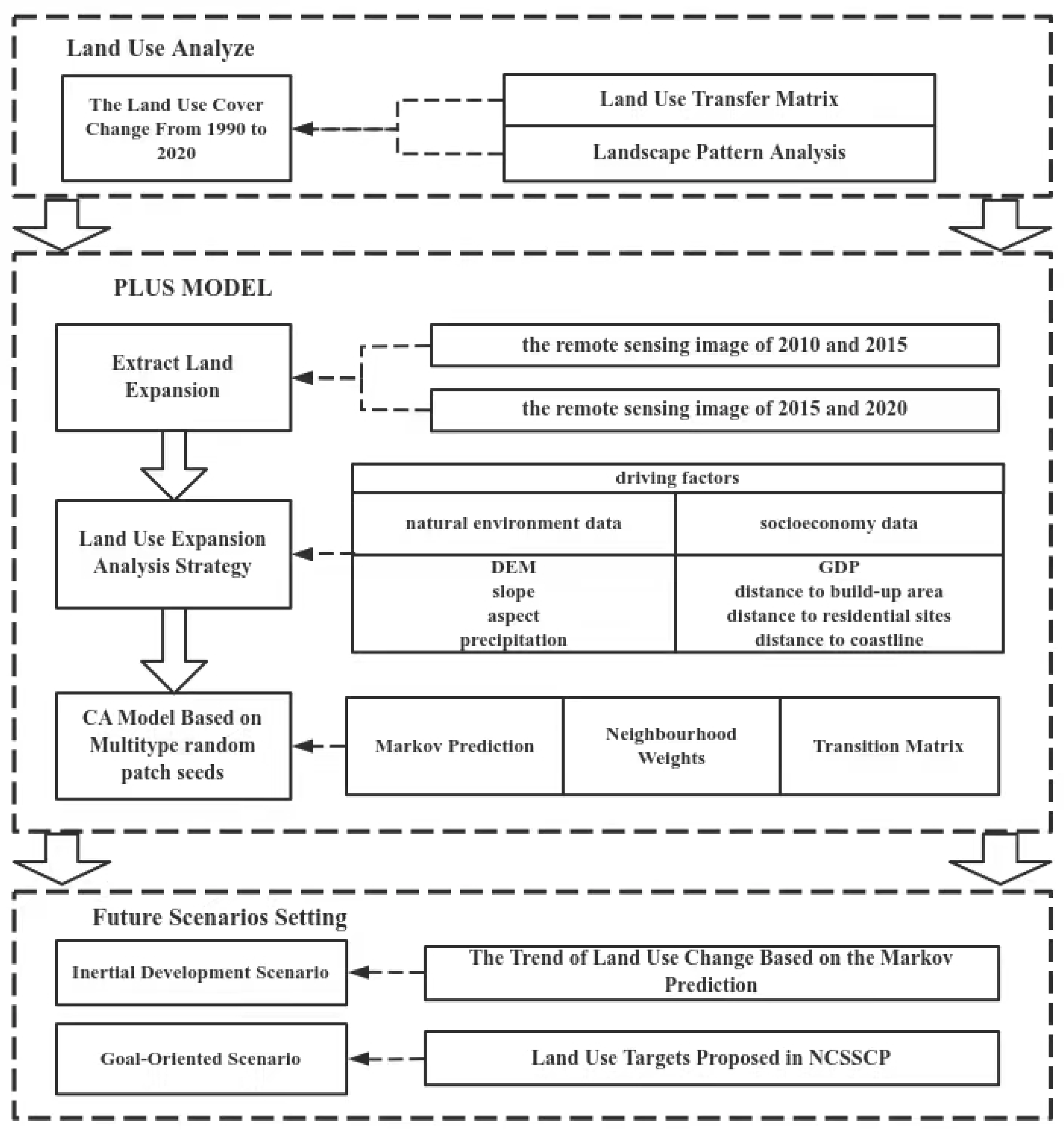
3.3. PLUS Model
3.4. Verification of the Kappa Index
3.5. Selection of the Driving Factors
- LUCC remote sensing images from 2010 to 2015 were used to simulate the LUCC in 2020 for the Kappa coefficient verification.
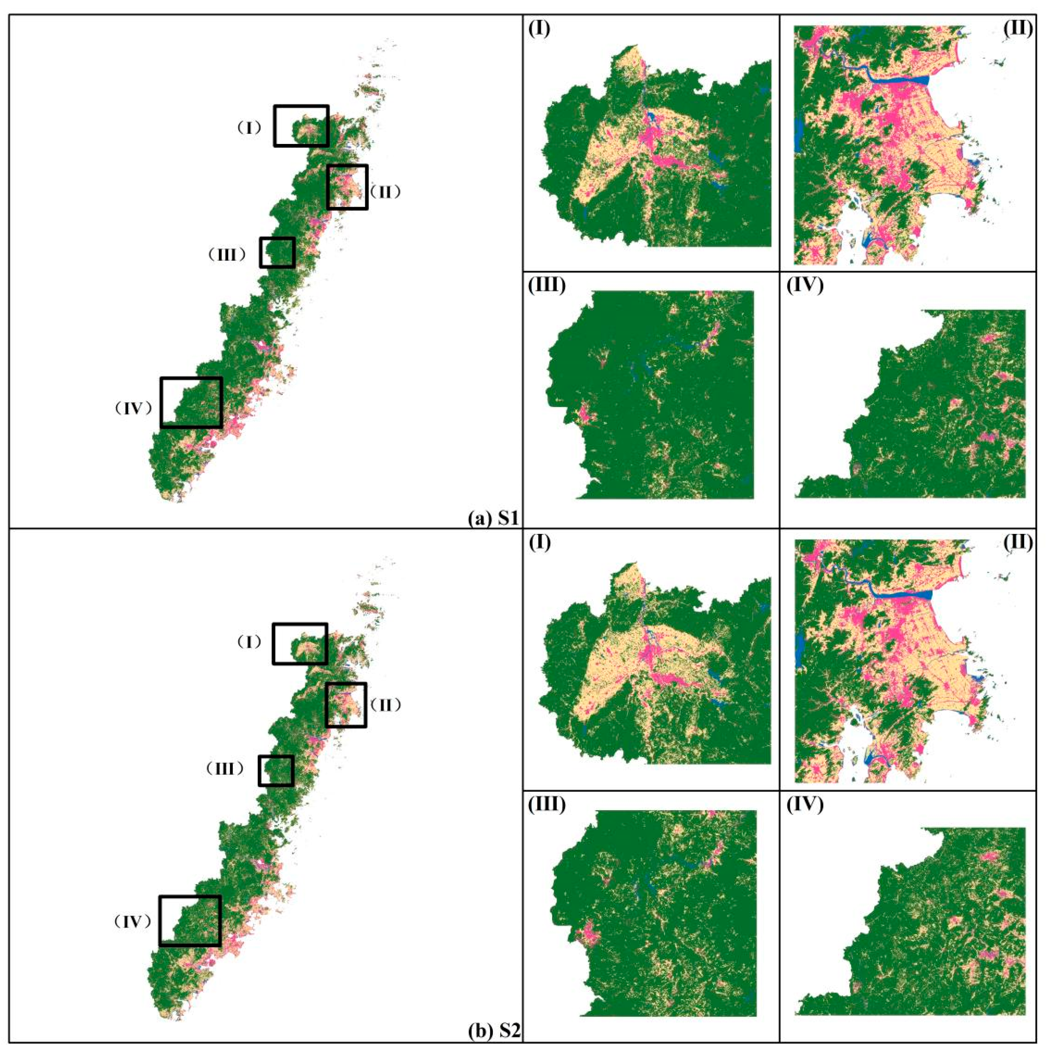
- LUCC remote sensing images from 2015 to 2020 were employed to simulate the LUCC under the effect of the NCSSCP in two scenarios.
4. Results
4.1. The Change of the LUCC
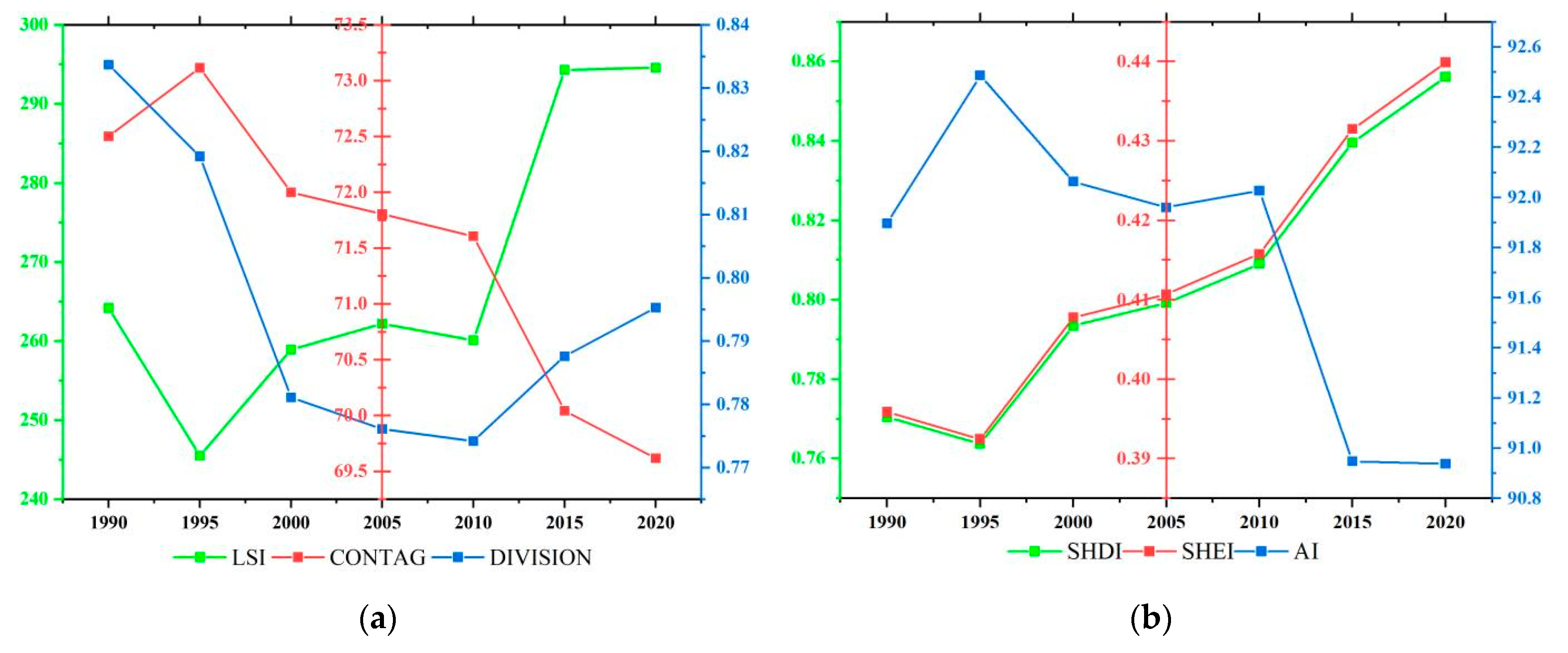
4.2. Landscape Pattern Index Analysis
4.3. Scenario Setting and Analysis
4.3.1. The LUCC Analysis of the Scenarios
4.3.2. The Landscape Pattern Index Analysis
5. Discussion
5.1. Simulation Result Analysis
5.2. Management Strategies for the Future Development of Land Resources
- –
- Continue to implement the NCSSCP and expand the total amount of forest resources in southeastern coastal areas. The implementation of the “Belt and Road” strategy and the concept of green development can be comprehensively promoted. Continuing the NCSSCP in the southeastern area is urgent for the further enhancement of the quality of the ecological environment and the acceleration of the construction of ecological civilization.
- –
- It is also necessary to further facilitate the afforestation and promote the greening construction of cities and their surroundings through scientific and effective means of construction and management. In southeastern coastal areas, the protection of shelterbelts should be strengthened in order to improve the disaster prevention.
- –
- Further improving forest coverage and increasing forest carbon sink can offset some industrial greenhouse gas emissions and reduce China’s total pollution. This is a crucial measure in order to actively respond to global warming.
- –
- The industrial structure of the southeastern coastal area should accelerate the change of the first industry to secondary and tertiary industries. NCSSCP should focus on achieving a net forest increase, as opposed to focusing on afforestation, which seems plausible but has an insufficient forest area due to urbanization. The ecological environment should be considered in the process of economic development in the southeastern coastal area.
- –
- The ecological system should be made more stable in order to promote sustainable development. The landscape pattern and spatial structure of the southeastern coastal area are relatively simple and complete. This indicates that the interaction between various types of land use should be elementary. Therefore, the following development should be clustered according to the landscape analysis.
5.3. Deficiencies and Prospects
6. Conclusions
Author Contributions
Funding
Institutional Review Board Statement
Informed Consent Statement
Data Availability Statement
Conflicts of Interest
References
- Jiang, P.; Cheng, L.; Li, M.; Zhao, R.; Duan, Y. Impacts of LUCC on soil properties in the riparian zones of desert oasis with remote sensing data: A case study of the middle Heihe River basin, China. Sci. Total Environ. 2015, 506–507, 259–271. [Google Scholar] [CrossRef] [PubMed]
- Faruque, M.J.; Vekerdy, Z.; Hasan, M.Y.; Islam, K.Z.; Young, B.; Ahmed, M.T.; Monir, M.U.; Shovon, S.M.; Kakon, J.F.; Kundu, P. Monitoring of land use and land cover changes by using remote sensing and GIS techniques at human-induced mangrove forests areas in Bangladesh. Remote Sens. Appl. Soc. Environ. 2022, 25, 100699. [Google Scholar] [CrossRef]
- National Coastal Shelterbelt System Construction Project Planning. 2017. Available online: http://www.gov.cn/xinwen/2017-05/16/5194348/files/8cfb540b5ff744518f1f05abdd201bdd.pdf (accessed on 1 March 2022).
- Zou, L.; Liu, Y.; Wang, J.; Yang, Y. An analysis of land use conflict potentials based on ecological-production-living function in the southeast coastal area of China. Ecol. Indic. 2021, 122, 107297. [Google Scholar] [CrossRef]
- Zou, J.; Lu, N.; Jiang, H.; Qin, J.; Yao, L.; Xin, Y.; Su, F. Performance of air temperature from ERA5-Land reanalysis in coastal urban agglomeration of Southeast China. Sci. Total Environ. 2022, 828, 154459. [Google Scholar] [CrossRef] [PubMed]
- Xiong, L.; Xi, B.; Wu, Y.; Liu, S.; Zhang, L.; Huang, X.; Macreadie, P.I. Nutrient input estimation and reduction strategies related to land use and landscape pattern (LULP) in a near-eutrophic coastal bay with a small watershed in the South China sea. Ocean Coast. Manag. 2021, 206, 105573. [Google Scholar] [CrossRef]
- Zou, L.; Liu, Y.; Wang, J.; Yang, Y.; Wang, Y. Land use conflict identification and sustainable development scenario simulation on China’s southeast coast. J. Clean. Prod. 2019, 238, 117899. [Google Scholar] [CrossRef]
- Zong, S.; Hu, Y.; Zhang, Y.; Wang, W. Identification of land use conflicts in China’s coastal zones: From the perspective of ecological security. Ocean Coast. Manag. 2021, 213, 105841. [Google Scholar] [CrossRef]
- Tian, Z.; Liu, F.; Liang, Y.; Zhu, X. Mapping soil erodibility in southeast China at 250 m resolution: Using environmental variables and random forest regression with limited samples. Int. Soil Water Conserv. Res. 2022, 10, 62–74. [Google Scholar] [CrossRef]
- Zhang, F.; Yang, X. Improving land cover classification in an urbanized coastal area by random forests: The role of variable selection. Remote Sens. Environ. 2020, 251, 112105. [Google Scholar] [CrossRef]
- Ji, Y.; Jin, J.; Zhu, Q.; Zhou, S.; Wang, Y.; Wang, P.; Xiao, Y.; Guo, F.; Lin, X.; Xu, J. Unbalanced forest displacement across the coastal urban groups of eastern China in recent decades. Sci. Total Environ. 2020, 705, 135900. [Google Scholar] [CrossRef]
- Xie, H.; Wang, G.G.; Yu, M. Ecosystem multifunctionality is highly related to the shelterbelt structure and plant species diversity in mixed shelterbelts of eastern China. Glob. Ecol. Conserv. 2018, 16, e00470. [Google Scholar] [CrossRef]
- Fan, L.; Tarin, M.W.K.; Zhang, Y.; Han, Y.; Rong, J.; Cai, X.; Chen, L.; Shi, C.; Zheng, Y. Patterns of soil microorganisms and enzymatic activities of various forest types in coastal sandy land. Glob. Ecol. Conserv. 2021, 28, e01625. [Google Scholar] [CrossRef]
- Liu, Y.; Xu, N.; Li, Z.; Wang, J.; Zeng, H. Differential impact of constructed land expansion on ecosystem health: A case study in the coastal region of the East China Sea. Ecol. Eng. 2022, 180, 106665. [Google Scholar] [CrossRef]
- Zhang, X.; Zhou, Y.; He, W.; Ju, W.; Liu, Y.; Bi, W.; Cheng, N.; Wei, X. Land cover change instead of solar radiation change dominates the forest GPP increase during the recent phase of the Shelterbelt Program for Pearl River. Ecol. Indic. 2022, 136, 108664. [Google Scholar] [CrossRef]
- Li, Z.; Wang, J.; Kong, X.; Zhang, B.; Liu, J.; Ding, S.; Du, Y. Effects of ecosystems preservation on economic growth in China’s coastal region: Multilevel modelling and exploration. Ecol. Indic. 2021, 132, 108224. [Google Scholar] [CrossRef]
- Liu, C.; Yang, M.; Hou, Y.; Xue, X. Ecosystem service multifunctionality assessment and coupling coordination analysis with land use and land cover change in China’s coastal zones. Sci. Total Environ. 2021, 797, 149033. [Google Scholar] [CrossRef]
- Lopez-Carr, D.; Davis, J.; Jankowska, M.; Grant, L.; Lopez-Carr, A.C.; Clark, M. Space versus Place in Complex Human-Natural Systems: Spatial and Multi-level Models of Tropical Land Use and Cover Change (LUCC) in Guatemala. Ecol. Model. 2012, 229, 64–75. [Google Scholar] [CrossRef] [Green Version]
- Song, K.; Zhao, J.; Ouyang, W.; Zhang, X.; Hao, F. LUCC and landscape pattern variation of wetlands in warm-rainy Southern China over two decades. Procedia Environ. Sci. 2010, 2, 1296–1306. [Google Scholar] [CrossRef] [Green Version]
- Wang, H.; Zhang, C.; Yao, X.; Yun, W.; Ma, J.; Gao, L.; Li, P. Scenario simulation of the tradeoff between ecological land and farmland in black soil region of Northeast China. Land Use Policy 2022, 114, 105991. [Google Scholar] [CrossRef]
- Gomes, E.; Banos, A.; Abrantes, P.; Rocha, J.; Schlapfer, M. Future land use changes in a peri-urban context: Local stakeholder views. Sci. Total Environ. 2020, 718, 137381. [Google Scholar] [CrossRef]
- Ye, L.; Yang, D.; Dang, Y.; Wang, J. An enhanced multivariable dynamic time-delay discrete grey forecasting model for predicting China’s carbon emissions. Energy 2022, 249, 123681. [Google Scholar] [CrossRef]
- Esgalhado, C.; Guimarães, M.H.; Lardon, S.; Debolini, M.; Balzan, M.V.; Gennai-Schott, S.C.; Simón Rojo, M.; Mekki, I.; Bouchemal, S. Mediterranean land system dynamics and their underlying drivers: Stakeholder perception from multiple case studies. Landsc. Urban Plan. 2021, 213, 104134. [Google Scholar] [CrossRef]
- Hu, X.; Luo, H.; Guo, M.; Wang, J. Ecological technology evaluation model and its application based on Logistic Regression. Ecol. Indic. 2022, 136, 108641. [Google Scholar] [CrossRef]
- Sylvester, J. The cover time of a (multiple) Markov chain with rational transition probabilities is rational. Stat. Probab. Lett. 2022, 187, 109534. [Google Scholar] [CrossRef]
- Basse, R.M.; Omrani, H.; Charif, O.; Gerber, P.; Bódis, K. Land use changes modelling using advanced methods: Cellular automata and artificial neural networks. The spatial and explicit representation of land cover dynamics at the cross-border region scale. Appl. Geogr. 2014, 53, 160–171. [Google Scholar] [CrossRef]
- Huang, W.; An, Y.; Pan, Y.; Li, J.; Chen, C. Predicting transient particle transport in periodic ventilation using Markov chain model with pre-stored transition probabilities. Build. Environ. 2022, 211, 108730. [Google Scholar] [CrossRef]
- Mokarram, M.; Pham, T.M. CA-Markov model application to predict crop yield using remote sensing indices. Ecol. Indic. 2022, 139, 108952. [Google Scholar] [CrossRef]
- Zhao, M.; He, Z.; Du, J.; Chen, L.; Lin, P.; Fang, S. Assessing the effects of ecological engineering on carbon storage by linking the CA-Markov and InVEST models. Ecol. Indic. 2019, 98, 29–38. [Google Scholar] [CrossRef]
- Zhang, Y.; Li, Y.; Lv, J.; Wang, J.; Wu, Y. Scenario simulation of ecological risk based on land use/cover change—A case study of the Jinghe county, China. Ecol. Indic. 2021, 131, 108176. [Google Scholar] [CrossRef]
- Zeng, L.; Liu, X.; Li, W.; Ou, J.; Cai, Y.; Chen, G.; Li, M.; Li, G.; Zhang, H.; Xu, X. Global simulation of fine resolution land use/cover change and estimation of aboveground biomass carbon under the shared socioeconomic pathways. J. Environ. Manag. 2022, 312, 114943. [Google Scholar] [CrossRef]
- Geng, J.; Shen, S.; Cheng, C.; Dai, K. A hybrid spatiotemporal convolution-based cellular automata model (ST-CA) for land-use/cover change simulation. Int. J. Appl. Earth Obs. Geoinf. 2022, 110, 102789. [Google Scholar] [CrossRef]
- Xie, L.; Wang, H.; Liu, S. The ecosystem service values simulation and driving force analysis based on land use/land cover: A case study in inland rivers in arid areas of the Aksu River Basin, China. Ecol. Indic. 2022, 138, 108828. [Google Scholar] [CrossRef]
- Yang, J.; Huang, X. The 30 m annual land cover dataset and its dynamics in China from 1990 to 2019. Earth Syst. Sci. Data 2021, 13, 3907–3925. [Google Scholar] [CrossRef]
- McGarigal, K.; Marks, B.J. FRAGSTATS: Spatial Pattern Analysis Program for Quantifying Landscape Structure; 1995. Available online: https://www.fs.fed.us/pnw/pubs/pnw_gtr351.pdf (accessed on 22 March 2022).
- Shehab, Z.N.; Jamil, N.R.; Aris, A.Z.; Shafie, N.S. Spatial variation impact of landscape patterns and land use on water quality across an urbanized watershed in Bentong, Malaysia. Ecol. Indic. 2021, 122, 107254. [Google Scholar] [CrossRef]
- Fu, F.; Deng, S.; Wu, D.; Liu, W.; Bai, Z. Research on the spatiotemporal evolution of land use landscape pattern in a county area based on CA-Markov model. Sustain. Cities Soc. 2022, 80, 103760. [Google Scholar] [CrossRef]
- Liang, X.; Guan, Q.; Clarke, K.C.; Liu, S.; Wang, B.; Yao, Y. Understanding the drivers of sustainable land expansion using a patch-generating land use simulation (PLUS) model: A case study in Wuhan, China. Comput. Environ. Urban Syst. 2021, 85, 101569. [Google Scholar] [CrossRef]
- Li, C.; Wu, Y.; Gao, B.; Zheng, K.; Wu, Y.; Li, C. Multi-scenario simulation of ecosystem service value for optimization of land use in the Sichuan-Yunnan ecological barrier, China. Ecol. Indic. 2021, 132, 108328. [Google Scholar] [CrossRef]
- Jiang, Y.; Huang, M.; Chen, X.; Wang, Z.; Xiao, L.; Xu, K.; Zhang, S.; Wang, M.; Xu, Z.; Shi, Z. Identification and risk prediction of potentially contaminated sites in the Yangtze River Delta. Sci. Total Environ. 2022, 815, 151982. [Google Scholar] [CrossRef]
- Han, J.; Hu, Z.; Mao, Z.; Li, G.; Liu, S.; Yuan, D.; Guo, J. How to Account for Changes in Carbon Storage from Coal Mining and Reclamation in Eastern China? Taking Yanzhou Coalfield as an Example to Simulate and Estimate. Remote Sens. 2022, 14, 2014. [Google Scholar] [CrossRef]
- Xu, L.; Liu, X.; Tong, D.; Liu, Z.; Yin, L.; Zheng, W. Forecasting Urban Land Use Change Based on Cellular Automata and the PLUS Model. Land 2022, 11, 652. [Google Scholar] [CrossRef]
- Kurnia, A.A.; Rustiadi, E.; Fauzi, A.; Pravitasari, A.E.; Saizen, I.; Ženka, J. Understanding Industrial Land Development on Rural-Urban Land Transformation of Jakarta Megacity’s Outer Suburb. Land 2022, 11, 670. [Google Scholar] [CrossRef]
- Zhai, H.; Lv, C.; Liu, W.; Yang, C.; Fan, D.; Wang, Z.; Guan, Q. Understanding Spatio-Temporal Patterns of Land Use/Land Cover Change under Urbanization in Wuhan, China, 2000–2019. Remote Sens. 2021, 13, 3331. [Google Scholar] [CrossRef]
- Li, C.; Yang, M.; Li, Z.; Wang, B. How Will Rwandan Land Use/Land Cover Change under High Population Pressure and Changing Climate? Appl. Sci. 2021, 11, 5376. [Google Scholar] [CrossRef]
- Shi, M.; Wu, H.; Fan, X.; Jia, H.; Dong, T.; He, P.; Baqa, M.F.; Jiang, P. Trade-Offs and Synergies of Multiple Ecosystem Services for Different Land Use Scenarios in the Yili River Valley, China. Sustainability 2021, 13, 1577. [Google Scholar] [CrossRef]


| Category | Data | Sources | Spatial Resolution |
|---|---|---|---|
| Natural environment data | DEM, slope, aspect | Geospatial data cloud (http://www.gscloud.cn/) (accessed on 16 March 2022) | 30 m |
| Precipitation | National Earth Systems Science Data Center (http://loess.geodata.cn) (accessed on 16 March 2022) | 30 m | |
| Socioeconomic data | GDP | Resource and Environmental Science Data Center (http://www.resdc.cn) (accessed on 17 March 2022) | 30 m |
| Distance to Build-up Area | Scientific data bank (https://www.scidb.cn) (accessed on 20 March 2022) | 1000 m | |
| Distance to Residential Sites | National Geographic Information Resources Directory Service System (https://www.webmap.cn/) (accessed on 20 March 2022) | 30 m | |
| Distance to Coastline | National Geographic Information Resources Directory Service System (https://www.webmap.cn/) (accessed on 21 March 2022) | 30 m | |
| LUCC | LUCC data in 1990, 1995, 2000, 2005, 2010, 2015, 2020 | CLCD from Wuhan University [34] | 30 m |
| Limit development data | Water area | - | - |
| Plan file | National Coastal Shelterbelt System Construction Project Planning | The Central People’s Government of the People’s Republic of China (http://www.gov.cn/) (accessed on 1 March 2022) | - |
| Landscape Pattern Index | Relation | Formulation | |
|---|---|---|---|
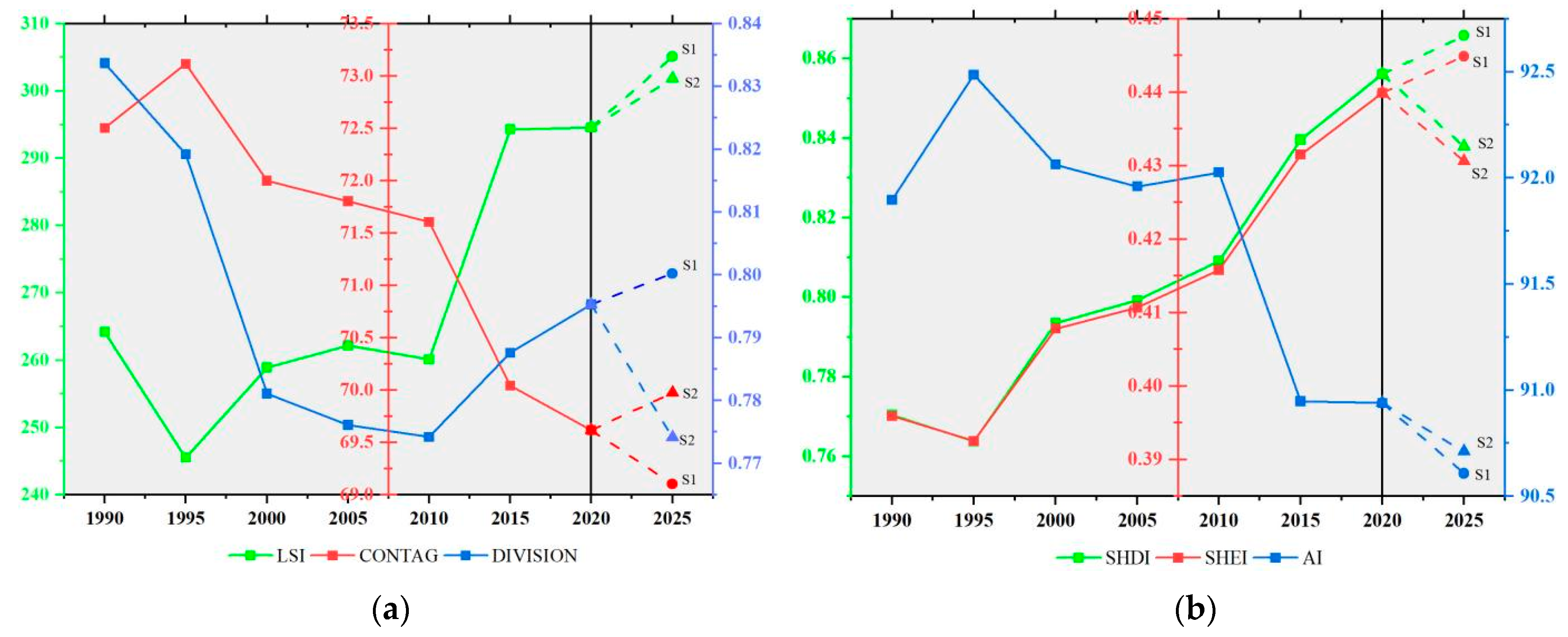
| Landscape fragmentation indicators | LSI | The larger the value, the more complex the shape of landscape patch and the higher the degree of landscape fragmentation. | |
| CONTAG | The larger the value, the higher the agglomeration degree between landscape patches, and the lower the landscape fragmentation degree. | ||
| DIVISION | The higher the degree of separation, the higher the degree of dispersion and fragmentation of the landscape system. | ||
| Landscape diversity indicators | AI | The larger the value, the more the same landscape patches gather, and the lower the landscape fragmentation degree. | |
| SHDI | The larger the value, the more heterogeneous the patches in the landscape pattern, and the more fragmented the landscape. | ||
| SHEI | The closer the value is to 1, the more evenly distributed the patchwork types are in landscape pattern. | ||
| The Type of Land Use | Cropland | Forest | Grassland | Water Area | Bare Land | Construction Land | Wetland |
|---|---|---|---|---|---|---|---|
| cropland | 1 | 1 | 1 | 1 | 0 | 1 | 0 |
| forest | 1 | 1 | 0 | 0 | 0 | 1 | 0 |
| grassland | 1 | 0 | 1 | 1 | 0 | 1 | 0 |
| water area | 1 | 0 | 0 | 1 | 0 | 1 | 0 |
| bare land | 1 | 0 | 1 | 0 | 1 | 1 | 0 |
| construction land | 0 | 0 | 0 | 0 | 0 | 1 | 0 |
| wetland | 0 | 0 | 0 | 1 | 0 | 1 | 1 |
| Neighborhood Weights | 0.2 | 0.395 | 0.05 | 0.15 | 0.025 | 0.155 | 0.025 |
| The First Phase of the NCSSCP | 2000 | |||||||
|---|---|---|---|---|---|---|---|---|
| 1990 | cropland | forest | grassland | water area | bare land | construction land | wetland | |
| cropland | 16,639,270 * | 3,338,626 | 24,168 | 411,278 | 2320 | 1,756,732 | 4739 | |
| forest | 2,657,734 | 61,317,184 * | 16,739 | 56,751 | 163 | 101,676 | 327 | |
| grassland | 102,678 | 57,675 | 31,231 * | 7001 | 4510 | 55,355 | 11 | |
| water area | 251,083 | 75,423 | 3147 | 1,605,966 * | 2028 | 136,339 | 5878 | |
| bare land | 7684 | 316 | 2384 | 3043 | 12,430 * | 8704 | 1 | |
| construction land | 286,889 | 40,442 | 3599 | 80,043 | 1012 | 1,207,111 * | 538 | |
| wetland | 1995 | 275 | 82 | 1906 | 68 | 541 | 205 * | |
| The second phase of the NCSSCP | 2015 | |||||||
| 2000 | cropland | forest | grassland | water area | bare land | construction land | wetland | |
| cropland | 15,167,729 * | 2,360,134 | 21,586 | 350,968 | 4758 | 2,089,479 | 1196 | |
| forest | 2,923,649 | 61,741,638 * | 9203 | 9821 | 320 | 188,344 | 0 | |
| grassland | 28,025 | 18,453 | 18,613 * | 3355 | 1733 | 12,502 | 0 | |
| water area | 215,173 | 18,425 | 3150 | 1,707,161 * | 6459 | 270,622 | 1461 | |
| bare land | 5064 | 87 | 644 | 5545 | 5201 * | 7209 | 0 | |
| construction land | 11,104 | 330 | 49 | 82,786 | 147 | 3,189,999 * | 0 | |
| wetland | 96 | 3 | 1 | 31 | 0 | 84 | 13,688 * | |
| The early stage of the third phase of the NCSSCP | 2020 | |||||||
| 2015 | cropland | forest | grassland | water area | bare land | construction land | wetland | |
| cropland | 13,450,195 * | 2,803,576 | 11,003 | 224,050 | 3912 | 1,790,566 | 4419 | |
| forest | 3,867,695 | 59,896,011 * | 8319 | 107,470 | 334 | 184,443 | 587 | |
| grassland | 19,594 | 13,533 | 3814 * | 1864 | 900 | 12,116 | 125 | |
| water area | 393,732 | 91,315 | 2994 | 1,380,425 * | 3740 | 201,203 | 5643 | |
| bare land | 5038 | 238 | 553 | 993 | 3868 * | 7067 | 16 | |
| construction land | 1,300,542 | 131,975 | 3372 | 106,786 | 4076 | 4,165,309 * | 2284 | |
| wetland | 3585 | 429 | 123 | 4884 | 1 | 2252 | 1858 * | |
Publisher’s Note: MDPI stays neutral with regard to jurisdictional claims in published maps and institutional affiliations. |
© 2022 by the authors. Licensee MDPI, Basel, Switzerland. This article is an open access article distributed under the terms and conditions of the Creative Commons Attribution (CC BY) license (https://creativecommons.org/licenses/by/4.0/).
Share and Cite
Bao, S.; Yang, F. Spatio-Temporal Dynamic of the Land Use/Cover Change and Scenario Simulation in the Southeast Coastal Shelterbelt System Construction Project Region of China. Sustainability 2022, 14, 8952. https://doi.org/10.3390/su14148952
Bao S, Yang F. Spatio-Temporal Dynamic of the Land Use/Cover Change and Scenario Simulation in the Southeast Coastal Shelterbelt System Construction Project Region of China. Sustainability. 2022; 14(14):8952. https://doi.org/10.3390/su14148952
Chicago/Turabian StyleBao, Shengwang, and Fan Yang. 2022. "Spatio-Temporal Dynamic of the Land Use/Cover Change and Scenario Simulation in the Southeast Coastal Shelterbelt System Construction Project Region of China" Sustainability 14, no. 14: 8952. https://doi.org/10.3390/su14148952
APA StyleBao, S., & Yang, F. (2022). Spatio-Temporal Dynamic of the Land Use/Cover Change and Scenario Simulation in the Southeast Coastal Shelterbelt System Construction Project Region of China. Sustainability, 14(14), 8952. https://doi.org/10.3390/su14148952


