Article

Types, Modes and Influencing Factors of Urban Shrinkage: Evidence from the Yellow River Basin, China

School of Geography and Environment, Shandong Normal University, Jinan 250358, China
*
Author to whom correspondence should be addressed.
Sustainability 2022, 14(15), 9213; https://doi.org/10.3390/su14159213
Submission received: 7 July 2022 / Revised: 22 July 2022 / Accepted: 24 July 2022 / Published: 27 July 2022

Abstract

:
Following the appearance of urban shrinkage in Western countries, scholars have taken note of increasing amounts of urban shrinkage with significant regional characteristics in China in recent years. Focusing on the Yellow River Basin, this study comprehensively measured prefecture-level and county-level city shrinkage based on China’s fifth, sixth and seventh national census data. Furthermore, the spatiotemporal patterns, types and modes of urban shrinkage were analyzed, and the factors influencing urban shrinkage were explored using a multiple linear regression model and a sorting model. The study results show that the number of shrinking cities and the shrinking degree significantly increased at the prefecture and county levels in the last 20 years. The identified shrinking cities are concentrated in the upper and middle reaches of the river basin, spatially configured around major cities and along the high-speed railway line. The regional pattern shows a typical “core–periphery” characteristic. Peripheral shrinkage is the main mode in which cities shrink. The strength and speed of economic development and industrial transformation positively affect urban shrinkage; the ageing degree, high-speed railway opening and other factors negatively affect urban shrinkage.

1. Introduction

In the mid-20th century, urban shrinkage characterized by massive population loss appeared successively in developed industrial countries, such as the United Kingdom and Germany [1,2]. These countries were global leaders of urbanization during the first and second industrial revolutions and first experienced severe population loss during the deindustrialization process in the 20th century, co-occurring with the emergence of a series of social problems [3,4]. In the 1980s, the German scholar Häußermann formally proposed the term “shrinking cities” to describe the phenomenon of population loss and economic decline in the Ruhr region of Germany as a result of deindustrialization and suburbanization [5]. Since then, urban shrinkage has received widespread scholarly attention, with new theoretical and empirical studies continually emerging to discuss the phenomenon in Western Europe, the United States, Japan and other developed countries. In the 21st century, scholars began to focus on urban shrinkage in developing countries, with significant results in China, Russia, etc. [6,7]. In an empirical study of urban shrinkage across the globe from 2000 to 2019, China was ranked first in terms of the number of shrinking cities, accounting for 13.6% of the shrinking cities worldwide [8]. Many studies have shown that deindustrialization has also affected China, with urban shrinkage concentrated in resource-based cities and old industrial bases [9]. Moreover, a growing body of research suggests that China’s shrinking cities include more than just these areas [10]. Even in China, which is still in a phase of rapid urbanization, it is no longer realistic to adhere to traditional forms of urban development and planning.
The loss of the urban population presents diverse shrinkage modes. Western scholars have divided shrinkage modes into two main categories based on the spatial distribution of depopulation. The first category is perforated shrinkage, represented by European industrial cities [11], as in the 1930s Manchester [2] and 1960s Liverpool and Leipzig [12]. Over time, these cities lost residents in several inner-city areas, resulting in a staggered distribution of growth plots and shrinkage plots within the city. The second category is doughnut shrinkage, represented by the Rust Belt in the northeastern United States [13], as exemplified by Detroit in the 1950s [14], where there was a massive population loss in the whole inner city. In addition, a few areas show anti-doughnut shrinkage, which describes the phenomenon of peripheral suburbs shrinking annularly and core areas growing, such as in the Paris region of France in the second half of the 20th century [15]. These typical shrinkage modes have prominent characteristics and appeared early, which provided comparative samples for the later study of urban shrinkage modes in different countries and regions. For example, in the 1990s, Izmir’s shrinkage was characterized by a doughnut shape [16] and in the 2000s Chiba prefecture in Tokyo experienced a mode of shrinkage defined as urban perforation [17]. Moreover, some shrinking cities in China show a phenomenon similar to the anti-doughnut mode [18].
Concerning the factors influencing urban shrinkage, many studies have focused on developed countries and have shown that demographic change, deindustrialization, suburbanization and globalization are the dominant factors of urban shrinkage [19,20]. For example, the problems of childlessness and population ageing are the leading causes of urban shrinkage in Japan. Deindustrialization and emigration are significant drivers of urban shrinkage in Germany. In the US, urban shrinkage is a regional phenomenon mainly found in the Rust Belt and metropolitan areas, accompanying deindustrialization and suburbanization as the primary causes of shrinkage. In addition, with globalization, the restructuring of global production relations has led to a crisis of urban shrinkage in industrial countries, as seen in Europe and the United States [21]. Unlike developed countries, China’s urban shrinkage resembles a microcosm of the uneven development between cities. Since the era of reform and opening up, China has experienced rapid industrialization and massive urban expansion, with significant trends identified as “migration to the cities” and the “flight of peacocks to the southeast” [22]. The growth of some cities has also led to shrinkage in the affected regions. This means that urban shrinkage in China cannot be attributed to the same causes as that in developed countries but must be comprehensively considered by synthesizing the characteristic factors of China’s urban development.
In 2019, the ecological conservation and high-quality development of the Yellow River Basin became part of the national strategy, and the urban growth and shrinkage of that area has attracted more scholarly attention. Studies have shown that urban shrinkage has existed for some time in the Yellow River Basin [23,24] and have greatly enhanced the understanding of urban shrinkage in the region. However, these studies are mostly scaled to the prefecture level. County cities, as the basic component of China’s urban system, also present the shrinkage phenomenon and need more attention. In addition, the types and modes of urban shrinkage have not been explored in depth. According to life cycle theory [25], there exists a classification of shrinkage patterns and a division of shrinkage degrees and shrinkage trajectories in urban shrinkage processes. Based on these results, from prefecture-level and county-level perspectives, using the periods 2000–2010 and 2010–2020, this work explores three questions: (1) What are the time-series changes in the proportion and degree of urban shrinkage in the Yellow River Basin? What degrees and trajectories of urban shrinkage can be observed?; (2) With recognition of the urban shrinking pattern at the prefecture and county levels, are there typical spatial structures and shrinkage modes in the Yellow River Basin?; (3) What factors influence the degree and mode of urban shrinkage in the Yellow River Basin? What are the similarities and differences in the drivers of urban shrinkage in the Yellow River Basin compared to those of Western developed countries with an earlier history of shrinkage? The study aims to provide empirical support for government and urban planners to promote the regrowth and high-quality development of shrinking cities in the Yellow River Basin and to contribute a typical case in China to the study of urban shrinkage globally.

2. Materials and Methods

2.1. Study Area

On the one hand, the Yellow River Basin spans three economic zones and the three natural regions of eastern, central and western China. The complex socioeconomic factors and natural conditions increase the diversity of urban shrinkage. On the other hand, many cities along the basin have developed over a long period and are in different urban development stages, which provides an opportunity to explore urban shrinkage in the context of urban development in China. This work draws upon the administrative division system of 2020 and defines 115 prefecture-level administrative units and 936 county-level administrative units in the Yellow River Basin as study units (Figure 1). To effectively measure urban shrinkage, the urban data of three time points are unified against the standard set by 2020 zoning. For prefecture-level cities without municipal districts under their jurisdiction (such as Alashan League and Manzhouli City), the area where the city administrative unit is located is counted as the municipal district. In contrast, county-level cities geographically within prefecture-level cities are unified as municipal counties.

2.2. Research Methods

2.2.1. Concept Definition and Measurement of Urban Shrinkage

At present, there is no unified definition of urban shrinkage. In this study, urban shrinkage is understood as a process of population reduction caused by various regional driving factors, showing different types and modes. Considering that population decline has been widely recognized as a key indicator for identifying and measuring urban shrinkage [26,27,28], based on census data registered by the National Bureau of Statistics of China every ten years, urban shrinkage is defined as the process in which the population change rate of a city is negative between two census years (i.e., 2000–2010 and 2010–2020). The word “shrinking cities” is a common expression used to describe places displaying signs of urban shrinkage. The urban shrinkage model has been widely used to measure urban shrinkage [29]. The calculation is shown in Equations (1) and (2).
S h r i n k i n g 1 = Δ p o p 1 = ( p o p 2010 p o p 2000 ) / p o p 2000 100 %
S h r i n k i n g 2 = Δ p o p 2 = ( p o p 2020 p o p 2010 ) / p o p 2010 100 % ,
where pop2000, pop2010, and pop2020 represent the population of the corresponding year. Shrinking1 and Shrinking2 represent the urban shrinkage rates in 2000–2010 and 2010–2020, respectively; when the urban shrinkage rate is negative, the urban area has shrunk in the corresponding period. The smaller the urban shrinkage rate, the greater the shrinkage degree of the city.

2.2.2. Multiple Linear Regression Model

The multiple linear regression model is a method for the quantitative analysis of influencing factors and is used to explore the effect of explanatory variables on explained variables. This study applies the multiple linear regression model to explore the influence of different factors on the urban shrinkage in the Yellow River Basin from 2000 to 2020 and tests the stability of the spatial measurement results. The model constructed is as follows:
S h r i n k i n g 3 = α 0 + i = 1 n β x i t + ε i t ,
where Shrinking3 is the explained variable and xit is the explanatory variable. i = 1..., N, indicating region i; t = 2000, 2010 or 2020, indicating the time.

2.2.3. Sorting Model

The sorting model is adapted to discrete data with natural ranking and can measure the influence of explanatory variables on ordinal variables. In the sorting model, the coefficients of the explanatory variables do not have a precise quantitative meaning, but their symbol and significance can still be used to judge the influence direction of the variables. When there are specific categories of shrinking cities in the Yellow River Basin, the sorting model can be applied to explore the influence direction of different factors on these categories. The model constructed is as follows:
S h r i n k i n g 4 = α 0 + i = 1 n β x i t + ε i t
S h r i n g k i n g 4 = 0 ( y r 0 ) , o r = 1 ( r 0 < y r 1 ) , o r = 2 ( r 1 < y r 2 ) , o r = J ( r J 1 < y r J )
where r0 < r1 <... < rJ are the parameters to be estimated, which are called cut points. Shrinking4 is the explained variable; Shrinking4 = 0, 1, 2...; xit is the explanatory variable. i = 1..., N, indicating region i; t = 2000, 2010 or 2020, indicating the period.

2.3. Indicator System and Data Sources

2.3.1. Selection of Influencing Factors of Urban Shrinkage

This study focuses on the main drivers of urban shrinkage in developed countries and the characteristic factors of urban shrinkage in China. Considering the natural and socioeconomic conditions of the Yellow River Basin, relevant studies [30,31,32], the data quality and availability, nine indicators are selected to construct a system affecting urban shrinkage in the Yellow River Basin, as shown in Table 1.

2.3.2. Data Sources

The population data come from China’s fifth, sixth and seventh population censuses. The socioeconomic data come from the China Urban Statistical Yearbook, statistical yearbooks and statistical bulletins relating to the prefectures and counties in the Yellow River Basin. High-speed railway data come from the OpenStreetMap website (https://www.openstreetmap.org (accessed on 17 May 2021)) and the announcement of the China National Railway Administration. The slope data are calculated based on the DEM raster data provided by the Geospatial Data Cloud website (https://www.gscloud.cn/#page2 (accessed on 25 June 2021)). The PM2.5 data come from the PM2.5 remote sensing dataset provided by the Atmospheric Composition Analysis Group of Washington University in St. Louis. (https://sites.wustl.edu/acag/datasets/surface-pm2-5/#V4.CH.03 (accessed on 20 October 2021)). The nighttime light data are from the first 2000–2020 global 500 m resolution NPP-VIIRS-like nighttime light dataset produced by a deep learning model [33].

3. Results

3.1. Temporal Evolution and Types of Urban Shrinkage in the Yellow River Basin

From 2000 to 2020, the number of shrinking cities showed a significant increase in the Yellow River Basin (Table 2). At the prefecture level, 34 cities and 57 cities experienced urban shrinkage in 2000–2010 and 2010–2020, accounting for 29.57% and 49.57% of all prefecture-level cities, respectively. The proportion of shrinking cities was higher at the county level than at the prefecture level, accounting for 38.46% and 65.28% of all county-level cities in 2000–2010 and 2010–2020, respectively. There were 52 shrinking municipal districts and 308 shrinking municipal counties between 2000 and 2010, accounting for 18.98% of municipal districts and 46.53% of municipal counties, respectively; between 2010 and 2020, the number of shrinking cities increased dramatically, at 108 municipal districts and 503 municipal counties, accounting for 39.42% of municipal districts and 75.98% of municipal counties. Above all, the shrinkage ratio of municipal counties is significantly higher than that of municipal districts, implying that a large population tends to leave the urban periphery (municipal counties) and gather in the urban center (municipal districts). In addition, many municipal districts have shrunk, reflecting that some people migrate from the urban centers to regional core cities with greater economic strength.
To objectively understand the process of urban shrinkage, this study further classifies shrinking types according to the shrinking degree and shrinking trajectory of shrinking cities in 2000–2010 and 2010–2020. Based on the urban shrinkage rate, the work uses ArcGIS’s natural breaking points method to classify the degree of shrinking cities into two types: slight shrinkage and severe shrinkage. To ensure comparability, the degree classification is standardized uniformly according to statistics from 2010–2020. Because prefecture-level and county-level cities have different shrinking degrees, they have different division standards. Based on the length of urban shrinkage, the trajectories of shrinking cities are classified into four types: worsening shrinkage, slowing shrinkage, steady shrinkage and recent shrinkage. The specific classification criteria are shown in Table 3.
The classification results of the urban shrinking degree in 2000–2010 and 2010–2010 are shown in Table 4. Between 2000 and 2010, slight shrinkage was the dominant type, accounting for 79.41% of all prefecture-level shrinking cities (27 out of 34) and 98.33% of all county-level shrinking cities (354 out of 360); severe shrinkage was less common, accounting for 20.59% of all prefecture-level shrinking cities (seven out of 34) and 1.67% of all county-level shrinking cities (six out of 360). Between 2010 and 2020, the proportion of cities with slight shrinkage decreased slightly, reaching 70.18% of all prefecture-level shrinking cities (40 out of 57) and 94.93% of all county-level shrinking cities (580 out of 611); meanwhile, the proportion of cities with severe shrinkage increased to 29.82% (17 out of 57) and 5.07% (31 out of 611) at the prefecture and county levels, respectively. Above all, most shrinking cities experienced slight shrinkage in the Yellow River Basin in 2000–2010 and 2010–2020, but the number and proportion of severely shrinking cities showed an upwards trend.
Cities in the Yellow River Basin are classified by their type of shrinking trajectory, as shown in Table 5, with 64 prefecture-level cities and 676 county-level cities following the predicted trajectory; i.e., these cities have a negative urban shrinkage rate in one or both study periods. Most cities present recent shrinkage among the prefecture and county levels, reaching 46.88% (30 out of 64) and 46.75% (316 out of 676), respectively; cities with worsening shrinkage represent the second-highest proportion, reaching 28.13% (18 out of 64) and 27.66% (187 out of 676); next are the cities with slowing shrinkage, with 14.06% (9 out of 64) and 15.98% (108 out of 676); and the cities with steady shrinkage are the lowest in number, accounting for 10.93% (7 out of 64) and 9.61% (65 out of 676). Furthermore, comparing the number of cities with steady shrinkage with the number of cities with worsening shrinkage and slowing shrinkage, nearly 1/5 of the shrinking cities in 2000–2010 evolved into non-shrinking cities in 2010–2020, while nearly 4/5 of them continued to shrink. Most shrinking cities in the Yellow River Basin show a continuous population decline. Moreover, there are more cities where the shrinking is worsening rather than slowing, demonstrating an increase in the shrinking degree of most shrinking cities. In addition, the large proportion of cities with recent shrinkage indicates that many cities began to shrink in 2010–2020, newly facing the challenge of continuous population decline.

3.2. Spatial Patterns and Modes of Urban Shrinkage in the Yellow River Basin

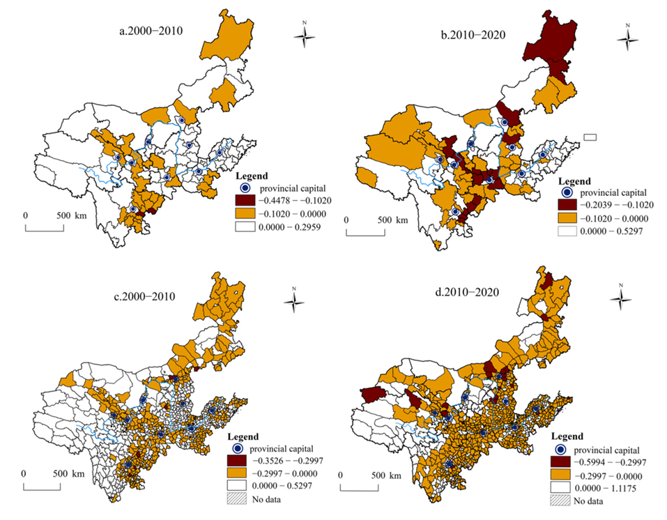
The spatial pattern of urban shrinkage in the Yellow River Basin is shown in Figure 2. At the prefecture level, shrinking cities are mainly concentrated in the upper and middle reaches of the Yellow River Basin. In addition, shrinking cities tend to present as block and circular agglomerations around main cities and core areas. For example, Wuwei, Zhangye, Haidong, Guyuan and other shrinking cities formed two semicircular shrinking areas surrounding the larger cities of Xining and Lanzhou in 2000–2010. In some zones along the high-speed rail line, there is a striped distribution of shrinking cities. For example, Tianshui, Dingxi, Baoji and other cities along the Lanxi high-speed railway shrank to form a continuous striped layout in 2010–2020; these cities were mainly located at interprovincial junctions. At the county level, between 2000 and 2010, the shrinking districts (counties) showed block and patchy cluster distributions mainly concentrated in the marginal areas of many provinces in the upper reaches. For example, the northeast of Qinghai Province and the northwest of Gansu Province were areas with a concentrated distribution of shrinking cities. Between 2010 and 2020, shrinking cities showed an extensive continuous distribution and were generally distributed in the peripheral regions of the Yellow River Basin. The proportion of shrinking cities in the middle and lower reaches increased significantly.
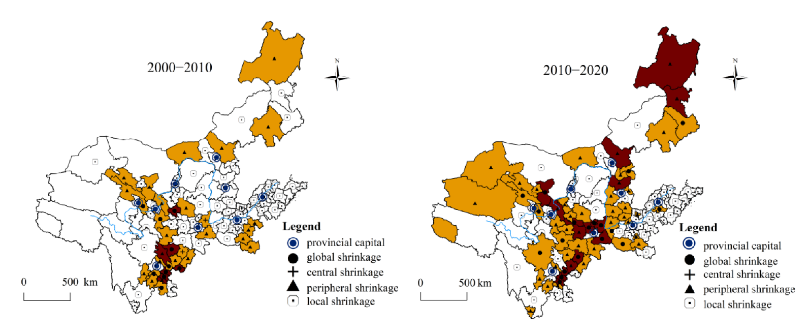
Above all, the shrinking cities’ spatial distribution and aggregation characteristics show a typical “core-periphery” characteristic in multiscale administrative divisions in the Yellow River Basin. At the prefecture level and above, the surrounding areas of the main cities and core areas in urban agglomerations and metropolitan areas tend to shrink significantly, while the main cities and core areas maintain stable growth. For example, the nine provincial capitals achieved population growth, and the growth rates were more than 10% in 2000–2010 and 2010–2020, while the population of their surrounding cities generally decreased. At the county level, municipal districts are still the preferred locations for population agglomeration, while municipal counties, with relatively undeveloped economies, are less attractive and are widely facing population decline. Considering this spatial characteristic, this study classifies the modes of prefecture-level shrinking cities according to the relationship between the shrinking states of municipal districts and counties. Considering that the municipal district is where a city’s economic activities are concentrated, shrinkage here is regarded as the shrinkage of the urban center, and the shrinkage of the municipal county is regarded as the shrinkage of the urban periphery. Finally, shrinking cities are classified into three modes: global shrinkage, meaning the shrinkage rate of the urban center (municipal district) and the urban periphery (municipal county) is negative; central shrinkage, meaning the shrinkage rate of the urban center is negative and the urban periphery is positive; and peripheral shrinkage, meaning the shrinkage rate of the urban center is positive and the urban periphery is negative. In addition, considering that some growing prefecture-level cities still have individual county-level units that are shrinking, this study designates a fourth shrinkage mode: local shrinkage, meaning the shrinkage rate of the whole city (prefecture-level city) is positive and local areas (individual county-level units) in the city are negative. It should be noted that local shrinking cities still show an increasing total population; however, a few county-level units in these cities experience a decrease in population, presenting an embedded structure of prefecture-level city growth and county-level unit shrinkage. Representative maps of the four modes are shown in Figure 3.
Figure 4 shows the distribution of the various modes of shrinking cities in the Yellow River Basin. There were 93 and 109 prefecture-level cities with global, central, peripheral or local shrinkage in 2000–2010 and 2010–2020, respectively. Between 2000–2010 and 2010–2020, the number of global shrinking cities increased from 10 to 19, and their proportion increased from 10.75% (10 of 93) to 17.43% (19 of 109). These cities are relatively scattered and mainly distributed in the upper and middle reaches of the river basin. Central shrinkage appeared only in 2000–2010 and occurred in only two cities, Weinan and Bazhong; it is worth noting that the two cities experienced global shrinkage in 2010–2020. Between 2000–2010 and 2010–2020, the number of peripheral shrinking cities increased from 17 to 38, and their proportion increased from 23.66% (17 of 93) to 34.86% (38 of 109). Above all, peripheral shrinkage is the primary shrinkage mode of shrinking cities in the Yellow River Basin. Peripheral shrinking cities are widely distributed across the region and show a block and circular agglomeration distribution. For example, from 2010 to 2020, Xinzhou, Lvliang and other cities formed a circular zone of depopulation around Taiyuan and Jinzhong, which confirms that the central cities have a strong attraction to the population in the periphery of the surrounding cities in the Yellow River Basin. In addition, the number and proportion of local shrinking cities decreased, with the number falling from 59 to 52 and the proportion decreasing from 63.44% (59 of 93) to 47.7% (52 of 109). Specifically, among the 59 local shrinking cities in 2000–2010, nearly three out of five of the cities still experienced local shrinkage in 2010–2020, nearly 2/5 of the cities evolved into peripheral shrinking cities or global shrinking cities in 2010–2020, and only one city achieved full growth in each of its county units in 2010–2020. Cities with local shrinkage may appear to be growing overall but may turn into shrinking cities over time. Cities with local shrinkage are widely distributed in the Yellow River Basin. In addition, the individual county-level units of some regional core cities, for example, Zhongmou and Gongyi in Zhengzhou City in 2010–2020, exhibit shrinkage mainly in the urban fringe. Due to the polarizing effect of cities experiencing growth, the population may cluster in the urban center, forming a spatial pattern of overall urban growth and local shrinkage.

3.3. Factors Influencing Urban Shrinkage in the Yellow River Basin

The multiple linear regression model and sorting model were used to analyze the influencing factors of urban shrinkage in the Yellow River Basin. The first model takes the urban shrinkage rate as the explained variable, reflecting the effect of influencing factors on the urban shrinking degree. The second model indicates the direction of influence of factors on the urban shrinkage mode as the explained variable. In model 2, the four modes of global shrinkage, central shrinkage, peripheral shrinkage and local shrinkage are assigned ranks of 1, 2, 3, and 4, respectively. In other words, the shrinking degree of cities is ranked from deep to shallow within the four modes, from the global shrinking city to the central shrinking city to the peripheral shrinking city to the local shrinking city. In addition, growing cities with a positive urban shrinkage rate in each county-level unit are assigned a rank of 5 in comparison with the four shrinking modes in the sorting model. The multiple linear regression model results are shown in Model 1 of Table 6. The sorting model adopts the ordered logit model (model 2(a)) and the ordered probit model (model 2(b)) for regression calculation. Following the comparison of the pseudo r2 values of model 2(a) and model 2(b) (the larger the pseudo r2 value, the better the explanatory variable explains the explained variable), the measurement results of “2000–2010” in model 2(b) and “2010–2020” in model 2(a) are used to analyze the influencing factors of the shrinkage mode. The results are analyzed as follows.

3.3.1. The Role of Various Influencing Factors in Urban Shrinkage

First, the study ranks the effect of the influencing factors in Model 1 and classifies the direction of the influence in Model 2. In Model 1, GDP, GDP_G, Ageing, Indust, HSM, HSM*GDP_G, Invest, PM2.5 and Slope pass the significance test, indicating that these factors affect the urban shrinkage rate; that is, they act on the urban population agglomeration and dispersion. The effects of the influencing factors are ranked according to the absolute value of the variable regression coefficient (|coef|) in 2000–2010 and 2010–2020. In 2000–2010, the order of effect is PM2.5 > Ageing > GDP > HSM > Indust > HSM*GDP_G. In 2010–2020, the order of effect is HSM*GDP_G > GDP > HSM > Ageing > GDP_G > Slope > Invest > PM2.5. In Model 2, GDP, GDP_G, Ageing, HSM, HSM*GDP_G, PM2.5 and Slope pass the significance test, indicating that these factors affect the urban shrinkage mode. Among them, GDP, GDP_G and HSM*GDP_G positively affect the urban shrinkage mode, while Ageing, HSM, PM2.5 and Slope negatively affect the urban shrinkage mode.

3.3.2. Economic Development Strength and Speed and Urban Shrinkage

In Model 1, GDP passes the 10% and 5% significance tests, and the regression coefficients increase from 0.1163 to 0.1628 in the two study periods; GDP_G does not pass the significance test in 2000–2010 but passes the 10% significance test in 2010–2020 with a coefficient of 0.0379. This result indicates that the strength and speed of economic development play an increasingly positive role in population dispersion. Cities with weak economies and slow economic development tend to experience population outflows, leading to urban shrinkage. In Model 2, GDP and GDP_G pass the 5% significance tests in 2010–2020, and the regression coefficients are positive (3.067 and 0.8115). This indicates that cities with low economic development strength and speed are also more likely to experience global shrinkage. This finding can explain the existence of shrinking zones around provincial capitals and core cities at the prefecture level and the mode of peripheral shrinkage. Theoretically, economically developed areas tend to have a powerful pull on the surrounding population. However, their limited economic power is not yet sufficient to produce a spill-over effect on their surrounding areas, leading to significant shrinkage of the surrounding cities.

3.3.3. Demographic Ageing Level and Urban Shrinkage

In Model 1 and Model 2, Ageing passes the 1% significance test with negative coefficients (−0.1990, −0.1410, −3.013, −3.719), and Ageing is at the forefront of the ranking of each variable by their coefficient in Model 1. Clearly, this factor, playing a vital role in urban shrinkage in Western countries, also affects city shrinkage in the Yellow River Basin. On the one hand, China’s long-standing one-child policy has resulted in a low birth rate for a long time, contributing to the rapid growth of the ageing rate and adding to the local economic burden. This is not conducive to a city’s development and contributes to the progress of urban shrinkage. On the other hand, a large ageing population means a shortage of young laborers, resulting in a lack of sufficient labor to support urban construction and blocking the improvement of urban economic vitality. This, in turn, weakens a city’s attractiveness to young people and aggravates the loss of the young population. These factors can accelerate urban shrinkage and increase the probability of global shrinkage.

3.3.4. Industrial Structure Transformation and Urban Shrinkage

In Model 1, Indust passes the 5% significance test, and the regression coefficient is positive (0.0691) in 2000–2010, indicating that industrial structure transformation has a positive effect on urban shrinkage. Upgrading the industrial structure can stimulate the economic vitality of cities and drive population inflows to effectively curb urban shrinkage. However, there is no significant correlation between urban shrinkage and Indust in 2010–2020, indicating that the industrial structure transformation does not have a sustained effect on urban population clustering in the Yellow River Basin. This can be understood in two ways. First, the degree of industrial structure transformation is slow, and the secondary industry is still the pillar industry in most cities. In the Yellow River Basin, the output value of the secondary industry in shrinking cities and industrial cities accounts for 39.55% and 43.22% of GDP, respectively. In contrast, in the UK and Germany—the countries that had an early industrial start—the secondary industry’s output value accounted for only 33.7% and 25.4% of GDP, respectively, as early as 2000. Second, combined with the theory of path dependency, many cities underwent a deindustrialization process to a high degree but with low quality due to technical constraints [34]. This incomplete deindustrialization has limited the sustainable role of industrial structure transformation in mitigating urban shrinkage. In Model 2, Indust fails to pass the significance test in both periods; that is, the industrial structure transformation has no impact on the urban shrinkage mode. Industrial development in urban areas brings more employment opportunities, and the population in all parts of the cities can find employment.

3.3.5. High-Speed Rail Opening and Urban Shrinkage

In Model 1, HSM passes the significance test at 1% and 5% in the two time periods, with negative coefficients of −0.1132 and −0.1503, respectively, showing that the high-speed rail opening in shrinking cities increases population outflow and intensifies urban shrinkage; this finding has been addressed in related studies [35]. HSM*GDP_G is introduced to further analyze the impact of high-speed rail on population agglomeration in cities with different levels of economic development. The results show that HSM*GDP_G passes the 1% significance test in both study periods, with regression coefficients of 0.0258 and 0.1885, respectively. This indicates that in cities with strong economies, high-speed rail opening pulls the population into the city and reduces the possibility of urban shrinkage. Conversely, in cities with economic disadvantages, high-speed rail opening accelerates the loss of urban population and further leads to urban shrinkage. This finding explains the spatial characteristics of the striped distribution of shrinking cities along the high-speed railway line in the Yellow River Basin. Cities with better economic development do not form a continuous striped layout. In Model 2, HSM passes the 1% significance test with a negative coefficient (−1.404), and HSM*GDP_G passes the 1% significance test with a positive coefficient (0.2686) in 2000–2010. This result indicates that high-speed rail opening increases the probability of cities experiencing global shrinkage. High-speed rail opening provides a convenient channel for urban young people and high-quality talent to work elsewhere, resulting in urban center decline due to the lack of labor force to construct the city and causing the emergence of central and even global shrinkage. In addition, HSM*GDP_G does not pass the significance test in 2010–2020, which can be explained by the fact that the improvement in high-speed railway facilities provided more equitable transport services for different groups of people within the city and enabled the population in the urban center and periphery to enjoy the same opportunities to migrate to other cities.

3.3.6. Urban Environment, Facility Construction Level and Urban Shrinkage

In Model 1 and Model 2, PM2.5 passes the 1% significance tests in 2000–2010, and the coefficients are negative (−0.2728, −2.008), indicating that the urban air environment had a negative effect on the degree and mode of urban shrinkage in 2000–2010. The deterioration of the urban air environment drives the population out to search for a better living environment. Especially in the urban center, where there are heavy haze conditions due to the long-term convergence of economic activities, residents choose to move out, forming central shrinkage and further leading to the phenomenon of global shrinkage. PM2.5 passes the 10% significance tests for 2010–2020 in Model 1, and the coefficients are positive (0.0049); however, the variable fails to pass the significance tests in Model 2. Although this shift in influencing direction and significance is contrary to the perception that deteriorating urban air environments reduce attractiveness to the population, it is understandable that higher urban PM2.5 values represent, to some extent, the existence of more intensive economic activities. Therefore, driven by economic interests, the population is more highly attracted to cities with high PM2.5 values, which reduces the urban shrinkage degree. In addition, the general improvement in the urban environment weakens the negative effect of urban air environmental problems on population growth. In particular, the environmental problems in urban centers receive more attention and treatment, which can effectively attract the urban population to stay in the center and reduce urban shrinkage and especially global shrinkage. In addition, the regression coefficient of PM2.5 drops in the ranking from first to last in the two time periods in Model 1, which is further proof that the influence of urban air conditions on population concentration is weakened. In Models 1 and 2, Slope does not pass the significance test in 2000–2010, but it passes the 5% and 1% significance tests with negative coefficients (−0.0083 and −0.2113) in 2010–2020, indicating that the negative effect of urban slope on the degree and mode of urban shrinkage is beginning to emerge. With the continuous expansion of the urban scale and the decrease in exploitable land, slope’s restrictive effect on urban land development becomes more pronounced, limiting the further concentration of the population and causing urban shrinkage. Notably, driven by urban growth, some shrinking cities experience contradictory development between population shrinkage and land expansion due to the continued development of urban land [36]. This can further aggravate urban shrinkage (especially urban central shrinkage), causing, for example, increases in unused infrastructure and abandoned urban greenery. In Model 1, Invest passes the 10% significance test for 2010–2020 with a negative coefficient (−0.0068), again suggesting that continued investment in infrastructure to maintain the appearance of urban growth in shrinking cities cannot effectively retain population.

4. Discussion

4.1. Validation and Supplementation of Urban Shrinkage Measures Based on Nighttime Lighting Data

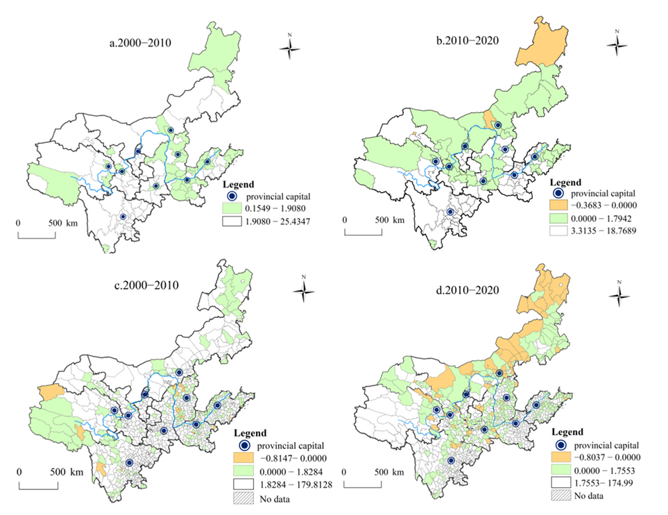
The article identifies shrinking cities in the Yellow River Basin using census data. In addition, nighttime light data are widely used in geography, and some scholars have applied nighttime light data as an indicator of urban population vitality instead of population data to measure urban shrinkage [37,38,39]; i.e., when the change rate of nighttime light value is negative, the city is in a state of shrinkage. Therefore, the study attempts to use nighttime lighting data to validate and supplement the above results of urban shrinkage measured by population data. Figure 5 shows the change rate of urban night light value; 1.9080, 1.7942, 1.8284 and 1.7553 represent the mean value of the nighttime light values of all prefecture-level and county-level cities in corresponding years. As a result, the majority of cities in the Yellow River Basin showed an increase in nighttime light values in 2000–2010 and 2010–2020, with only 3.3% (31 out of 936) of county-level cities in 2000–2010, 3.5% (4 out of 115) of prefecture-level cities and 7.6% (71 out of 936) of county-level cities in 2010–2020 having lower nighttime light values. This conclusion differs significantly from the measurement results of shrinking cities based on population data. Understandably, this study takes ten years as the research period to measure whether cities are shrinking; however, under the background of the rapid development of urbanization in China, the economic development and population vitality of cities also tend to show an upwards trend, even in cities with a declining population. It is clear that applying nighttime light data does not effectively measure shrinking cities on a long time scale. Furthermore, this study compares the mean value of the nighttime light values of the shrinking cities identified in this study (i.e., cities with negative population change rates) with the mean value of the nighttime light values of all cities in the Yellow River Basin. The results show that the mean value of shrinking cities is lower than that of all cities in the Yellow River Basin at the three study points of 2000, 2010 and 2020. From this perspective, the conclusion can demonstrate the reliability of the measurement results of shrinking cities based on population data.

4.2. A Comparison of Typical Patterns of Urban Shrinkage in the Yellow River Basin and Western Developed Countries

The urban shrinkage in the Yellow River Basin forms a typical spatial pattern and differs significantly from that of Western countries. Global shrinkage, central shrinkage and peripheral shrinkage are the three modes describing the pattern of shrinking cities in the Yellow River Basin, with peripheral shrinkage as the primary urban shrinkage mode, representing a pattern of population decrease in urban peripheries (municipal counties) against an increase in urban centers (municipal districts) due to uneven development. However, in Western developed countries, where urbanization is advanced and the difference in the level of economic development within cities is slight, the concept of “peripheralization” is more commonly used at the metropolitan scale to explain the regional spatial structure formed by the migration of many people from the periphery to the center of the metropolitan area [40]. Regarding the urban shrinkage mode, Western scholars have introduced the concepts of doughnut shrinkage and perforated shrinkage, describing the spatial structures of inner cities that have formed doughnut-shaped or perforation-shaped shrinkage due to deindustrialization and suburbanization. The central shrinkage mode identified in this study is similar to doughnut shrinkage and perforated shrinkage spatially, both describing urban centers that have declined and lost population. However, there are differences in the causes, population destinations and urban impacts of these shrinkage modes. Central shrinkage is driven by lagging development of the urban center, which leads the population to move to other cities and may eventually cause global shrinkage (e.g., Weinan and Bazhong in the Yellow River Basin). Doughnut shrinkage and perforated shrinkage are driven by deindustrialization and suburbanization, leading to population migration to the suburbs, which results in a spatial redistribution of the population between the inner city and the suburbs [41].

4.3. Analysis of the Influencing Factors of Urban Shrinkage in the Yellow River Basin in the Context of China’s Urban Development

The influencing factors of urban shrinkage of the Yellow River Basin closely reflect the characteristics of urban development in China. Demographic change, deindustrialization, suburbanization and globalization are widely recognized as the main drivers of urban shrinkage in developed countries, and these drivers show the same or different effects in the urban shrinkage process in the Yellow River Basin. Unlike the main drivers of urban shrinkage in developed countries, economic development plays a key role in the urban shrinkage of the Yellow River Basin. Similar to the large-scale population movements between developed and less-developed regions during globalization, within the Yellow River Basin, there are distinct migration paths due to the gradient differences in economic development between regions, which are reflected between the upstream, midstream and downstream regions, as well as between the regional center and the regional periphery. This study uses the ageing degree to characterize demographic change. This dominant factor influencing urban shrinkage in developed countries also has a persistent negative effect on the urban shrinkage process in the Yellow River Basin. However, different from the influence of the ageing problem in developed countries, in the Yellow River Basin, the combination of high ageing with accelerated urbanization has a strong influence on cities. This combination prevents cities with low urbanization from experiencing urban shrinkage in the long term due to the continuous lack of young laborers to build the cities. In addition, deindustrialization and industrial restructuring do not have the same impact on urban shrinkage in the Yellow River Basin as in developed countries, where deindustrialization and the accompanying suburbanization have led to urban shrinkage. In the Yellow River, deindustrialization and industrial restructuring have instead increased the city’s attractiveness for a period of time. In addition, due to the difference in urban development stage between the Yellow River Basin and developed countries, suburbanization, as the main driving force of urban shrinkage in developed countries, has not played a significant role in the Yellow River Basin.
In addition, high-speed rail opening, the urban air environment and other regional factors have created significant push-and-pull effects on urban population agglomeration in the Yellow River Basin. In the context of uneven economic development between regions, high-speed railways opening has provided more opportunities for people to migrate to central and developed regions and has led to severe population outflows in peripheral and less-developed regions. In addition, the urban air environment has both a negative and a positive effect on urban population movement. On the one hand, residents’ pursuit of a better living environment leads cities with a worse environment to experience urban shrinkage, similar to the cause of suburbanization in developed countries. On the other hand, this phenomenon does not persist in the cities of the Yellow River Basin. Because the gradient of urban development strength is large and the deterioration of the urban air environment is often linked to the level of urban development, people are driven by economic efficiency to ignore environmental problems and stay in these cities. Moreover, the general improvement in the urban air environment in recent years has weakened the negative impact of urban air environment problems. In addition, the natural environment and infrastructure development negatively affect urban shrinkage in the Yellow River Basin; it is intuitively shown that the blind development of urban land and the uncontrolled construction of infrastructure have not led to the return of the urban population but have exacerbated the urban shrinkage phenomenon. This phenomenon is also reflected in the process of urban shrinkage in developed countries. Taking Leipzig and Berlin as an example, there is contradictory development between urban land expansion, facilities construction and population shrinkage [42].

4.4. Urban Shrinkage Brings Opportunities and Challenges to Achieving High-Quality Development

Although the phenomenon of urban shrinkage has received increasing scholarly attention, local governments continue to treat urban shrinkage as a negative phenomenon and neglect it during the period of accelerated urbanization centered on urban growth, and they implement growth-oriented planning to maintain the appearance of urban growth even in shrinking cities with severe population decline. However, this measure can aggravate the phenomenon of urban shrinkage, leading to issues such as increasing housing vacancies and rising crime rates in cities [43]. It is important to note that urban shrinkage is not equal to urban recession and may even bring new development opportunities to cities. Lang introduced the concepts of “concentration” and “peripheralization” to emphasize that urban shrinkage is a result of a social development process that accompanies local spatial concentration [44]. Harrt studied North American shrinking cities as examples, demonstrating that urban depopulation can coexist with economic prosperity [45]. Furthermore, in some shrinking cities, local authorities and planners have begun to emphasize the concept of “smart shrinkage” as opposed to the traditional concept of urban growth, including urban regeneration in Germany [46,47], right-sizing in the USA [48] and the compact city policy in Japan [17]. In the wave of urban growth, it is important for shrinking cities to consider whether to adhere to the traditional “growth orientation” method or adopt the emerging “smart shrinkage” strategy.

5. Conclusions

Using the cities of the Yellow River Basin, this study reveals the types and modes of urban shrinkage under the administrative division system and explores the factors influencing urban shrinkage in the Yellow River Basin from a global perspective and with attention to the local context of urban development in China. The measurement results of urban shrinkage show that the number of shrinking cities at the prefecture and county levels increased in 2000–2010 and 2010–2020. In addition, the degree of urban shrinkage shows a quantitative ranking of “slight shrinkage > severe shrinkage”, and the trajectory classification shows a quantitative ranking of “recent shrinkage > worsening shrinkage > slowing shrinkage > steady shrinkage”. Based on the spatial pattern of shrinking and nonshrinking cities, there is a typical “core-periphery” pattern in the multiscale administrative divisions in the Yellow River Basin. In terms of influencing factors, economic development strength and speed are the key factors driving urban population change; the ageing degree is also a persistent influencing factor in urban shrinkage; industrial structure transformation has a phased positive effect on urban shrinkage. In addition, high-speed railway opening, the urban natural environment and the facility construction level play a negative role in urban shrinkage. The influence of the urban air environment on the degree of urban shrinkage changes from negative to positive, and its influence on the mode of shrinkage changes from significant to nonsignificant. These conclusions can provide an empirical reference for policy makers to formulate strategies to cope with urban shrinkage.
This article focuses on the cities in nine provinces along the Yellow River Basin and helps reveal the characteristics of urban shrinkage in developing countries. In addition, from the perspective of a river basin, it provides a case study and theoretical support for national and local governments to promote the regrowth and high-quality development of shrinking cities. The study hopes to draw the attention of more scholars and planners to the phenomenon of urban shrinkage, which, as a phase of the urban development process, should not be ignored under the influence of growthism. Creating a “people-oriented” urban development philosophy is the key to retaining the urban population [49]. From this perspective, urban shrinkage can also be an important opportunity for cities to achieve high-quality development.

Author Contributions

Conceptualization, X.D. and C.W.; methodology, C.W. and X.D.; formal analysis, S.Y., Y.M. and X.D.; data curation, Z.J. and Y.M.; writing—original draft preparation, X.D. and S.Y.; writing—review and editing, C.W. and X.D.; visualization, Z.J. and Y.M.; supervision, C.W.; project administration, C.W.; funding acquisition, C.W. All authors have read and agreed to the published version of the manuscript.

Funding

This research was funded by the National Social Science Foundation of China, grant number 20BJY070; the Natural Science Foundation of Shandong Province in China, grant number ZR2019MD043.

Institutional Review Board Statement

Not applicable.

Informed Consent Statement

Not applicable.

Data Availability Statement

The data presented in this study are available on request from the corresponding author.

Acknowledgments

We express our sincere thanks to the editor and anonymous reviewers for their comments and suggestions, which considerably helped to improve the quality of this study. We are solely responsible for the opinions expressed in this study.

Conflicts of Interest

The authors declare no conflict of interest.

References

  1. Nelle, A.; Großmann, K.; Haase, D.; Kabisch, S.; Rink, D.; Wolff, M. Urban shrinkage in Germany: An entangled web of conditions, debates and policies. Cities 2017, 69, 116–123. [Google Scholar] [CrossRef]
  2. Rieniets, T. Shrinking Cities: Causes and Effects of Urban Population Losses in the Twentieth Century. Nat. Cult. 2009, 4, 231–254. [Google Scholar] [CrossRef]
  3. Lima, M.; Thompson, C.; Aspinall, P. Friendly Communities and Outdoor Spaces in Contexts of Urban Population Decline. Land 2020, 9, 439. [Google Scholar] [CrossRef]
  4. Lee, J.; Park, Y.; Kim, H. Evaluation of Local Comprehensive Plans to Vacancy Issue in a Growing and Shrinking City. Sustainability 2019, 11, 4966. [Google Scholar] [CrossRef] [Green Version]
  5. Häußermann, H.; Siebel, W. Die Schrumpfende Stadt und Die Stadtsoziologie; Soziologische Stadtforschung: Wiesbaden, Germany, 1988; pp. 78–94. [Google Scholar]
  6. Meng, X.; Long, Y. Shrinking cities in China: Evidence from the latest two population censuses 2010–2020. Environ. Plan. A Econ. Space 2022, 54, 449–453. [Google Scholar] [CrossRef]
  7. Gunko, M.; Eremenko, Y.; Batunova, E. Planning Strategies in the Context of Urban Shrinkage in Russia: Evidence from Small and Medium-sized Cities. Mir Ross. Universe Russ. 2020, 29, 121–141. [Google Scholar]
  8. Meng, X.; Jiang, Z.; Wang, X.; Long, Y. Shrinking cities on the globe: Evidence from LandScan 2000–2019. Environ. Plan. A Econ. Space 2021, 53, 1244–1248. [Google Scholar] [CrossRef]
  9. Wang, R.; Wang, C.; Zhang, S.; Ding, X. A study on the spatial and temporal evolution of urban shrinkage and its influencing factors from a multidimensional perspective: A case study of resource-based cities in China. PLoS ONE 2021, 16, e0258524. [Google Scholar] [CrossRef]
  10. Yang, Y.; Wu, J.; Wang, Y.; Huang, Q.; He, C. Quantifying spatiotemporal patterns of shrinking cities in urbanizing China: A novel approach based on time-series nighttime light data. Cities 2021, 118, 103346. [Google Scholar] [CrossRef]
  11. Nuissl, H.; Rink, D. The ‘production’ of urban sprawl in eastern Germany as a phenomenon of post-socialist transformation. Cities 2005, 22, 123–134. [Google Scholar] [CrossRef]
  12. Couch, C.; Karecha, J.; Nuissl, H.; Rink, D. Decline and sprawl: An evolving type of urban development–observed in Liverpool and Leipzig. Eur. Plan. Stud. 2005, 13, 117–136. [Google Scholar] [CrossRef]
  13. Blanco, H.; Alberti, M.; Olshansky, R.; Chang, S.; Wheeler, S.; Randolph, J.; London, J.; Hollander, J.; Pallagst, K.; Schwarz, T.; et al. Shaken, shrinking, hot, impoverished and informal: Emerging research agendas in planning. Prog. Plan. 2009, 72, 195–250. [Google Scholar] [CrossRef]
  14. Thompson, E.; de Beurs, K. Tracking the removal of buildings in rust belt cities with open-source geospatial data. Int. J. Appl. Earth Obs. Geoinf. 2018, 73, 471–481. [Google Scholar] [CrossRef]
  15. Pallagst, K. The planning research agenda: Shrinking cities—A challenge for planning cultures. Town Plan. Rev. 2010, 81. [Google Scholar] [CrossRef]
  16. Özatağan, G.; Eraydın, A. The Role of Government Policies and Strategies Behind the Shrinking Urban Core in an Expanding City Region: The Case of Izmir. Eur. Plan. Stud. 2014, 22, 1027–1047. [Google Scholar] [CrossRef] [Green Version]
  17. Usui, H.; Perez, J. Are patterns of vacant lots random? Evidence from empirical spatiotemporal analysis in Chiba prefecture, east of Tokyo. Environ. Plan. B Urban Anal. City Sci. 2022, 49, 777–793. [Google Scholar] [CrossRef]
  18. Ma, Q.; Gong, Z.; Kang, J.; Tao, R.; Dang, A. Measuring Functional Urban Shrinkage with Multi-Source Geospatial Big Data: A Case Study of the Beijing-Tianjin-Hebei Megaregion. Remote Sens. 2020, 12, 2513. [Google Scholar] [CrossRef]
  19. Karp, D.; Bagchi-Sen, S.; Rogerson, P. Not all shrinking places are similar: The variegated nature of population decline in the United States. Appl. Geogr. 2022, 138, 102581. [Google Scholar] [CrossRef]
  20. Mallach, A.; Haase, A.; Hattori, K. The shrinking city in comparative perspective: Contrasting dynamics and responses to urban shrinkage. Cities 2017, 69, 102–108. [Google Scholar] [CrossRef]
  21. Martinez-Fernandez, C.; Audirac, I.; Fol, S.; Cunningham-Sabot, E. Shrinking cities: Urban challenges of globalization. Int. J. Urban Reg. Res. 2012, 36, 213–225. [Google Scholar] [CrossRef]
  22. Li, J.; Zhang, H.; Sun, Z. Spatiotemporal variations of land urbanization and socioeconomic benefits in a typical sample zone: A case study of the Beijing-Hangzhou Grand Canal. Appl. Geogr. 2020, 117, 102187. [Google Scholar] [CrossRef]
  23. Niu, W.; Xia, H.; Wang, R.; Pan, L.; Meng, Q.; Qin, Y.; Li, R.; Zhao, X.; Bian, X.; Zhao, W. Research on Large-Scale Urban Shrinkage and Expansion in the Yellow River Affected Area Using Night Light Data. ISPRS Int. J. Geo-Inf. 2021, 10, 5. [Google Scholar] [CrossRef]
  24. Jin, Z.; Wang, C.; Yu, S.; Zhang, S.; Ding, X. Spatiotemporal evolution and influencing factors of urban shrinkage in the Yellow River Basin, China. PLoS ONE 2022, 17, e0264236. [Google Scholar] [CrossRef]
  25. Haase, A.; Bernt, M.; Großmann, K.; Mykhnenko, V.; Rink, D. Varieties of shrinkage in European cities. Eur. Urban Reg. Stud. 2016, 23, 86–102. [Google Scholar] [CrossRef]
  26. Wolff, M.; Wiechmann, T. Urban growth and decline: Europe’s shrinking cities in a comparative perspective 1990–2010. Eur. Urban Reg. Stud. 2018, 25, 122–139. [Google Scholar] [CrossRef]
  27. Segers, T.; Devisch, O.; Herssens, J.; Vanrie, J. Conceptualizing demographic shrinkage in a growing region–Creating opportunities for spatial practice. Landsc. Urban Plan. 2020, 195, 103711. [Google Scholar] [CrossRef]
  28. Yang, Z.; Dunford, M. City shrinkage in China: Scalar processes of urban and hukou population losses. Reg. Stud. 2018, 52, 1111–1121. [Google Scholar] [CrossRef]
  29. Zhang, Y.; Fu, Y.; Kong, X.; Zhang, F. Prefecture-level city shrinkage on the regional dimension in China: Spatiotemporal change and internal relations. Sustain. Cities Soc. 2019, 47, 101490. [Google Scholar] [CrossRef]
  30. Guo, F.; Qu, X.; Ma, Y.; Tong, L. Spatiotemporal pattern evolution and influencing factors of shrinking cities: Evidence from China. Cities 2019, 119, 103391. [Google Scholar] [CrossRef]
  31. Wang, S.; Guo, J.; Luo, X.; Liu, J.; Gu, Z. Spatial Impact of High-speed Railway on the Urban Scale:An Empirical Analysis from Northeast China. Chin. Geogr. Sci. 2020, 30, 366–378. [Google Scholar] [CrossRef]
  32. Guan, D.; He, X.; Hu, X. Quantitative identification and evolution trend simulation of shrinking cities at the county scale, China. Sustain. Cities Soc. 2021, 65, 102611. [Google Scholar] [CrossRef]
  33. Chen, Z.; Yu, B.; Yang, C.; Zhou, Y.; Yao, S.; Qian, X.; Wang, C.; Wu, B.; Wu, J. An extended time series (2000–2018) of global NPP-VIIRS-like nighttime light data from a cross-sensor calibration. Earth Syst. Sci. Data 2021, 13, 889–906. [Google Scholar] [CrossRef]
  34. Liu, C.; Yang, P. A Comparative Study on the Motivation Mechanism and Performance Characteristics of Chinese and Foreign Shrinking Cities. Mod. Urban Res. 2017, 24, 64–71. [Google Scholar] [CrossRef]
  35. Deng, T.; Wang, D.; Yang, Y.; Yang, H. Shrinking cities in growing China: Did high speed rail further aggravate urban shrinkage? Cities 2018, 86, 210–219. [Google Scholar] [CrossRef]
  36. Song, X.; Feng, Q.; Xia, F.; Li, X.; Scheffran, J. Impacts of changing urban land-use structure on sustainable city growth in China: A population-density dynamics perspective. Habitat Int. 2021, 107, 102296. [Google Scholar] [CrossRef]
  37. Yang, D.; Luan, W.; Yang, J.; Xue, B.; Zhang, X.; Wang, H.; Pian, F. The contribution of data-driven poverty alleviation funds in achieving mid-21st-Century multidimensional poverty alleviation planning. Humanit. Soc. Sci. Commun. 2022, 9, 179. [Google Scholar] [CrossRef]
  38. Dong, B.; Ye, Y.; You, S.; Zheng, Q.; Huang, L.; Zhu, C.; Tong, C.; Li, S.; Li, Y.; Wang, K. Identifying and Classifying Shrinking Cities Using Long-Term Continuous Night-Time Light Time Series. Remote Sens. 2021, 13, 3142. [Google Scholar] [CrossRef]
  39. You, H.; Yang, J.; Xue, B.; Xiao, X.; Xia, J.; Jin, C.; Li, X. Spatial evolution of population change in Northeast China during 1992–2018. Sci. Total Environ. 2021, 776, 146023. [Google Scholar] [CrossRef]
  40. Ribant, M.; Chen, X. A typology of U.S. Shrinking Cities. Prof. Geogr. 2020, 72, 152–164. [Google Scholar] [CrossRef]
  41. Schetke, S.; Haase, D. Multi-criteria assessment of socio-environmental aspects in shrinking cities. Experiences from eastern Germany. Environ. Impact Assess. Rev. 2007, 28, 483–503. [Google Scholar] [CrossRef]
  42. Dubeaux, S.; Sabot, E. Maximizing the potential of vacant spaces within shrinking cities, a German approach. Cities 2018, 75, 6–11. [Google Scholar] [CrossRef]
  43. Batunova, E.; Gunko, M. Urban shrinkage: An unspoken challenge of spatial planning in Russian small and medium-sized cities. Eur. Plan. Stud. 2018, 26, 1580–1597. [Google Scholar] [CrossRef]
  44. Lang, T. Shrinkage, Metropolization and Peripheralization in East Germany. Eur. Plan. Stud. 2012, 20, 1747–1754. [Google Scholar] [CrossRef]
  45. Hartt, M. The diversity of North American shrinking cities. Urban Stud. 2018, 55, 2946–2959. [Google Scholar] [CrossRef]
  46. Radzimski, A. Involving small landlords as a regeneration strategy under shrinkage: Evidence from two East German cases. Eur. Plan. Stud. 2017, 26, 526–545. [Google Scholar] [CrossRef]
  47. Knippschild, R.; Zöllter, C. Urban Regeneration between Cultural Heritage Preservation and Revitalization: Experiences with a Decision Support Tool in Eastern Germany. Land 2021, 10, 547. [Google Scholar] [CrossRef]
  48. Coppola, A. Projects of becoming in a right-sizing shrinking City. Urban Geogr. 2019, 40, 237–256. [Google Scholar] [CrossRef]
  49. Franklin, R. The demographic burden of population loss in US cities, 2000–2010. J. Geogr. Syst. 2019, 23, 209–230. [Google Scholar] [CrossRef] [Green Version]
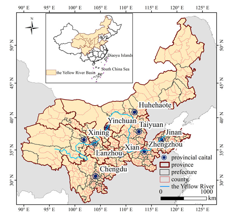
Figure 1. Study area: the Yellow River Basin.
Sustainability 14 09213 g001
Figure 2. Spatial characteristics of urban shrinkage.
Sustainability 14 09213 g002
Figure 3. Four modes of urban shrinkage.
Sustainability 14 09213 g003
Figure 4. Spatial distribution of shrinking cities with different shrinkage modes.
Sustainability 14 09213 g004
Figure 5. Statistics of night light change rate in cities.
Sustainability 14 09213 g005
Table 1. Indicator system construction.
Variable Variable Description
Economic development strength (GDP)Gross National Product of base period
Economic development speed (GDP_G)Gross National Product growth rate
Ageing degree (Ageing)The change rate of ageing rate
Industrial structure transformation (Indust) The change rate of the ratio of tertiary industry GDP to secondary industry GDP
High-speed railway opening (HSM)A binary variable taking the value 1 if the city is severed by a high-speed railway and 0 in other cases
High-speed railway opening_economic development (HSM*GDP_G)The interaction variable between the variable high-speed railway opening and the variable economic development speed
Urban air environment (PM2.5)The average value of Z value change rate of all units in PM2.5 raster data
Urban natural environment (Slope)The average value of Z value change rate of all units in DEM raster data.
Facility construction level (Invest)The change rate of investment in fixed assets
Note: * indicates the product of two variables.
Table 2. Statistics of shrinking cities at the prefecture and county levels.
LevelUnitStatistic2000–20102010–2020
ShrinkageNon-ShrinkageTotalShrinkageNon-ShrinkageTotal
PrefectureCityNumber34811155758115
Rate29.57%70.43%100%49.57%50.43%100%
CountyMunicipal countyNumber308354662503159662
Rate46.53%53.47%100%75.98%24.02%100%
Municipal districtNumber52222274108166274
Rate18.98%81.02%100%39.42%60.58%100%
TotalNumber360576936611325936
Rate38.46%61.54%100%65.28%34.72%100%
Table 3. Criteria for the classification of shrinking city types.
Classification of Shrinking DegreeDivision StandardClassification of Shrinking TrajectoryDivision Standard
Slight shrinkage[−0.1020,0)
(prefecture level)
Worsening shrinkageShrinking2 < Shrinking1 < 0
[−0.2040,−0.1020) (county level)Slowing shrinkageShrinking1 < Shrinking2 < 0
Severe shrinkage[−0.2997,0)
(prefecture level)
Recent shrinkageShrinking2 < 0 < Shrinking1
[−0.5994,−0.2997) (county level)Steady shrinkageShrinking1 < 0 < Shrinking2
Note: Shrinking1 refers to urban shrinkage in 2000–2010; Shrinking2 refers to urban shrinkage in 2010–2020.
Table 4. Statistics on the classification of shrinking degrees of prefecture-level and county-level shrinking cities.
LevelStatistic2000–20102000–2010
Slight ShrinkageSevere ShrinkageTotalSlight ShrinkageSevere ShrinkageTotal
PrefectureNumber27734401757
Rate79.41%20.52%100%70.18%29.82%100%
CountyNumber354636058031611
Rate98.33%1.67%100%94.93%5.07%100%
Table 5. Statistics on the classification of shrinking trajectories of prefecture-level and county-level shrinking cities.
LevelStatisticWorsening ShrinkageSlowing ShrinkageRecent ShrinkageSteady ShrinkageTotal
PrefectureNumber18930764
Rate28.13%14.06%46.88%10.93%100%
CountyNumber18710831665676
Rate27.66%15.98%46.75%9.61%100%
Table 6. Results of model regression calculation.
Model 1Model 2
(a)(b)
Variables2000–20102010–20202000–20102010–20202000–20102010–2020
GDP0.1163 *
(1.75)
0.1628 **
(2.49)
0.8520
(0.66)
3.067 **
(2.11)
0.4334
(0.66)
1.567 *
(1.95)
GDP_G0.0067
(1.64)
0.0379 *
(1.78)
0.0073
(0.08)
0.8115 **
(1.78)
−0.0083
(0.08)
0.5791 **
(2.28)
Ageing−0.1990 ***
(−4.14)
−0.1410 ***
(−4.21)
−5.286 ***
(−4.78)
−3.719 ***
(−3.79)
−3.013 ***
(−4.78)
−1.648 ***
(−3.90)
Indust0.0691 **
(2.48)
0.0021
(0.18)
0.6616
(1.18)
−0.2136
(−0.79)
0.3080
(1.18)
−0.0563
(−0.40)
HSM−0.1132 ***
(−2.71)
−0.15030 **
(−2.44)
−2.153 **
(−2.55)
0.2392
(0.19)
−1.404 ***
(−2.55)
0.1563
(0.21)
HSM*GDP_G0.0258 ***
(3.17)
0.1885 ***
(3.81)
0.3892 **
(2.22)
−0.8996
(−0.84)
0.2686 ***
(2.22)
−0.4868
(−0.79)
PM2.5−0.2728 ***
(−4.61)
0.0049 *
(1.95)
−3.488 ***
(−2.81)
0.0856
(1.61)
−2.008 ***
(−2.81)
0.0631 **
(2.10)
Slope0.0045
(1.48)
−0.0083 **
(−2.48)
0.0292
(0.50)
−0.2113 ***
(−3.00)
0.0092
(0.50)
−0.1305 ***
(−3.26)
Invest−0.0001
(−0.08)
−0.0068 *
(−1.95)
0.0066
(0.42)
−0.0688
(−1.02)
0.0030
(0.42)
−0.0372
(−0.90)
Number of observations115115115115115115
Average VIF2.022.622.022.622.022.62
R2/Pseudo R20.45130.50400.17510.16560.17990.1463
Note: ***, **, * respectively indicate that they have passed the significance test of 1%, 5% and 10%. The values in the table represent the coefficient value of the variable in the regression, and the values in () represent the Z value of the regression result.
Publisher’s Note: MDPI stays neutral with regard to jurisdictional claims in published maps and institutional affiliations.