Abstract
Taken as a classical issue in applied economics, the notion of ‘convergence’ is based on the concept of path dependence, i.e., from the previous trajectory undertaken by the system during its recent history. Going beyond social science, a ‘convergence’ perspective has been more recently adopted in environmental studies. Spatial convergence in non-linear processes, such as desertification risk, is a meaningful notion since desertification represents a (possibly unsustainable) development trajectory of socio-ecological systems towards land degradation on a regional or local scale. In this study, we test—in line with the classical convergence approach—long-term equilibrium conditions in the evolution of desertification processes in Italy, a European country with significant socioeconomic and environmental disparities. Assuming a path-dependent development of desertification risk in Italy, we provided a diachronic analysis of the Environmental Sensitive Area Index (ESAI), estimated at a disaggregated spatial resolution at three times (1960s, 1990s, and 2010s) in the recent history of Italy, using a spatially explicit approach based on geographically weighted regressions (GWRs). The results of local regressions show a significant path dependence in the first time interval (1960–1990). A less significant evidence for path-dependence was observed for the second period (1990–2010); in both cases, the models’ goodness-of-fit (global adjusted R2) was satisfactory. A strong polarization along the latitudinal gradient characterized the first observation period: Southern Italian land experienced worse conditions (e.g., climate aridity, urbanization) and the level of land vulnerability in Northern Italy remained quite stable, alimenting the traditional divergence in desertification risk characteristic of the country. The empirical analysis delineated a more complex picture for the second period. Convergence (leading to stability, or even improvement, of desertification risk) in some areas of Southern Italy, and a more evident divergence (leading to worse environmental conditions because of urban sprawl and crop intensification) in some of the land of Northern Italy, were observed, leading to an undesired spatial homogenization toward higher vulnerability levels. Finally, this work suggests the importance of spatially explicit approaches providing relevant information to design more effective policy strategies. In the case of land vulnerability to degradation in Italy, local regression models oriented toward a ‘convergence’ perspective, may be adopted to uncover the genesis of desertification hotspots at both the regional and local scale.
1. Introduction
Derived from the economic literature, ‘convergence’ has been a paradigmatic notion for decades. Since the 1990s, this concept was more frequently adopted to interpret social and environmental problems, adapting the predictions of economic convergence theory to different, possibly more complex, issues [1,2,3]. Convergence approaches imply a quantitative analysis of developmental paths characteristic of complex systems evolving toward distinctive growth stages over time and space with intrinsic regulation of the latent system’s properties [4,5,6]. This long-term path depends on the system state at the beginning of the observation period and on the evolution steps at various investigation times. Path dependence from the previous trajectory, during its recent history, is clearly at the base of such a process. Global convergence implies that all the different components of the system evolve synergistically towards a target objective, which is generally a policy objective or a non-regulatory target (i.e., an objective dictated (or mediated) by human preferences instead of political instruments). Local convergence implies a spatially heterogeneous process where only some units tend to converge over time.
The notion of convergence derives from a wide economic literature initially focusing on the long-term evolution of production systems [7,8,9,10]. These studies were mainly oriented toward the investigation of national (or supranational) systems where the different units (e.g., regions or individual countries) converge to steady-state equilibrium conditions (e.g., the same long-term growth rate). This assumption implies that the poorest units grow more than the rich ones and, consequently, territorial disparities are reduced [11,12,13]. Economic divergence instead implies a territorial polarization in rich and poor areas, caused by a differential growth regime separating affluent countries, more equipped with resources and infrastructures, from poor countries, experiencing a structural gap in resources and infrastructures [14,15]. These two alternative conditions can be analyzed in different spatiotemporal domains taking into account the impact of local background contexts.
The ‘convergence’ issue has become popular in political analysis because it is commonly seen as a target for policy strategies addressing, both directly and indirectly, the reduction of territorial gaps and the promotion of a long-term (and spatially sustainable) economic growth, promoting resilience of local systems [16,17]. At the same time, this concept has been applied in social science when addressing the intrinsic relationship between sociodemographic phenomena and institutional mechanisms having a strict linkage with policy regulation mechanisms, as in the case of identifying a welfare regime in advanced economies [18,19,20]. Since the early 2000s, the ‘convergence’ notion has also been applied to environmental processes under intense political regulation, and characterized by structural territorial disparities [21,22,23].
What has been done so far in the ecological field requires, however, additional research aimed at broadening the analysis to a wider range of environmental processes possibly connected with the sociodemographic context. Enabling refined investigation techniques and methodologies relying on an unprecedented amount of digital data—provided with a more frequent temporal resolution and with a higher spatial detail—is a pre-requisite for such studies [22]. An environmental process that was preliminarily investigated under a convergence framework was land degradation, defined as a ‘reduction in the economic value of ecosystem services and goods derived from land as a result of anthropogenic activities or natural biophysical evolution’ [23]. Land degradation is a worldwide issue [24,25,26,27,28,29,30], which can be assumed to be representative of a long-term development trajectory of a given socio-ecological system characterized by intrinsic impulses towards complexity on either regional or local scales [31,32,33,34]. Internal forces shaping long-term evolutionary paths depend on the intrinsic features of local systems, implying human actions aimed at regulating these processes, but also at supplying or using (more or less sustainably) natural resources connected with these phenomena. External drivers have finally influenced land degradation both directly (as in the case of (i) unsustainable urbanization resulting in urban sprawl; (ii) grazing regime determining high soil erosion rates and loss in plant productivity; (iii) extensive land transformations in semi-arid climates causing the expansion of barrens; and (iv) wildfires causing damages to biodiversity) and indirectly (as in the case of climate change), being frequently associated with anthropogenic activities [33,34,35,36,37,38,39,40,41,42].
The intrinsic complexity of developmental paths in local systems affected by land degradation reflects non-linear trajectories of growth in advanced economies (as already demonstrated in [43]) and, therefore, needs monitoring procedures at finer spatiotemporal resolutions aimed at evaluating the driving forces that guide this path [44]. In other words, understanding the trajectories of such systems implies the opportunity to design multi-scalar policies that may contain the negative effects of those forces triggering (or exacerbating) land degradation. At the same time, these policies may more effectively contribute to regulating the impact of human activities, as in the case of the adoption of specific agri-environmental measures to contrast degradation in eroded vineyards and critical areas [45,46]. Other examples of such policies include soil conservation measures slowing down land abandonment, such as building/consolidation of terraced slopes able to contain some processes (runoff, erosion, landslides) in fragile Mediterranean catchments [47,48]. These policies can also mitigate the effect of exogenous shocks, such as climate change, and maintain a resilience potential to preserve the pristine stock of resources [49,50]. In this context, it is reasonable to assume a development process that is, at least partially, dependent on the previous path. An intrinsically complex, path-dependent process is strictly linked to the previous development state while being subjected to external forces moving the system away from the initial conditions. Testing against spatial imbalances, the present study verifies a long-term equilibrium in the evolution of land degradation processes in Italy, a European country with intense socioeconomic divides [51,52].
Generally speaking, the issue of land degradation has now become very topical throughout Europe, because the Old Continent has experienced rising levels of land degradation, and 13 European Union (EU) Member States have declared themselves as affected parties under the United Nations Convention to Combat Desertification (UNCCD). At both the European and global level, as reported in the latest institutional reports (e.g., European Environment Agency, Intergovernmental Panel On Climate Change, Intergovernmental Science-Policy Platform on Biodiversity and Ecosystem Services, see [53,54,55]), land is drastically degrading. A significant expansion of degraded areas aligns Italy with global and European trends: now, over a third of the national territory should be considered partially or completely degraded [56]. To document convergence (or divergence) processes in the evolution of desertification risk, we tested a path-dependent development of land degradation analyzing spatiotemporal variations in a composite index, the ESAI (Environmental Sensitive Area Index [57,58]), at a relatively detailed geographical resolution at three time points (1960s, 1990s, and 2010s) corresponding to different stages of the socioeconomic development path in Italy.
The adopted model follows a classic convergence scheme testing path dependence between the early 1960s and the early 1990s, and between the early 1990s and the early 2010s. Salvati et al. [59] have previously explained the importance of these two periods in the history of Italy as representative of socioeconomic, demographic, and territorial dynamics common to other Mediterranean countries. The first time interval (1960–1990) was characterized by a development path not associated with specific policies mitigating desertification impacts and, because of this context, the period can be labeled as ‘pre-codified desertification’. Only in the mid-1990s, with the establishment of the United Nations Convention to Combat Desertification (UNCCD) and the corresponding National Committees, specific policies have been promoted to face the desertification risk in Italy, as well as in the other Mediterranean countries of the UNCCD Annex IV. Notably, the Italian Committee to Combat Drought and Desertification (CNLSD) has been fully active since 1999 and promoted actions at the national level with the National Action Plan (NAP), which introduced guiding principles for designing policy strategies at the regional scale, e.g., through the Regional Action Plans (RAPs). These were spatial planning tools that each regional administration should have developed on the basis of the specific degradation processes and in line with NAP guidelines. Local action plans, aimed at containing desertification risk and maintaining an appropriate stock of natural resources, were occasionally proposed. This implies that a comprehensive analysis of territorial dynamics over the second observation period allows for the estimation of the initial impact of the national strategy for land degradation mitigation in Italy [60].
Based on these premises, we run—for the first time, to our knowledge—a quantitative analysis of convergence processes in the evolution of the desertification risk over time based on a pixel-based, local regression, controlling for the modifiable area unit problem (MAUP)—characteristic in the use of administrative units. Taken as a function of (supposedly) different evolutionary paths, we run a regression analysis between the stock of land resources (i.e., reflecting the level of vulnerability) at two consecutive times (t = 0 and t = 1), as derived from spatially explicit ESAI values and change over two time spans (1960–1990 and 1990–2010). We assume that the level of land degradation vulnerability converges over space with reduced territorial gaps, determining a less asymmetric distribution of the ESAI over time. Formal or informal actions (i.e., spontaneous or regulatory) may regulate this path. By contrast, we expect divergence when the existing gaps widen and, consequently, the variations over time exacerbate these spatial divides. Divergence, in turn, creates spatial polarizations with the consequent formation (or consolidation) of land degradation hotspots, i.e., serious conditions of land vulnerability, which may evolve towards desertification.
2. Materials and Methods
2.1. Study Area
Italy is a Northern Mediterranean country extending more than 300,000 km2 and is composed of balanced, mainly steep topography mixing lowlands (23%), uplands (42%), and mountains (35%). Climate regimes in Italy were highly dependent on topography, latitude, and distance from the sea coasts, ranging from Alpine to semi-arid [61,62]. The distribution of natural resources and human activities across the study area reflects the historical interplay between biophysical factors and anthropogenic pressures, revealing economic and sociopolitical disparities (such as the land accessibility favored by different transport infrastructure, income levels, etc.). The country’s geography is delineated considering three macro-regions (North, Centre, and South), displaying important differences, as far as population density, urban form, availability of natural resources, topographic features, and economic well-being, are concerned (Figure 1). Northern Italy has an economic profile similar to the most developed European areas, while Southern Italy is still considered a region with a developmental deficit [63]. Central Italy is positioned in-between these regions and alternates between areas with thriving activities and economically disadvantaged zones (basically, rural and mountain areas). These pronounced differences generate a diverse range of ecosystems responses to natural and anthropogenic disturbance, sometimes exacerbated by the effects of climate change (e.g., irregular precipitation regimes, heatwaves, late frost events, and flooding [64,65,66]). Thanks to such factors, Italy is particularly suitable for testing the impact of these geographical gradients in the spatial distribution of vulnerable areas to land degradation [67,68,69].
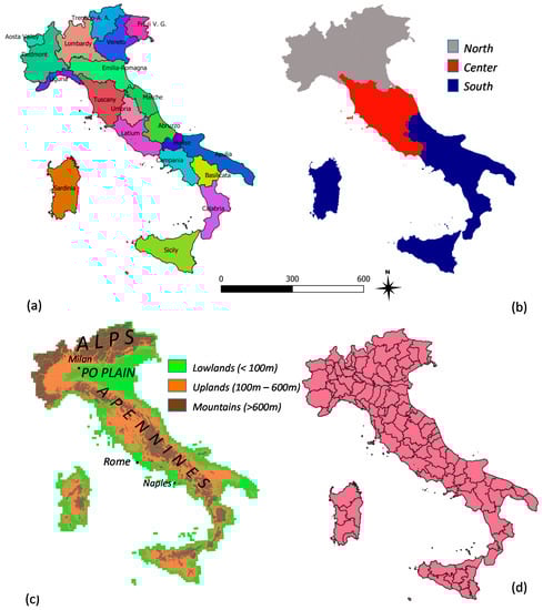
Figure 1.
Partitions of the study area into (a) 20 regions corresponding to NUTS-2 (European nomenclature of territorial units for official statistics); (b) latitudinal belts; (c) elevation classes; (d) 107 provinces corresponding to NUTS-3 level in Italy.
2.2. ESA Approach
In this work, we adopted one of the most used methodologies in the field of desertification/land degradation: the ESA (Environmentally Sensitive Area) approach. It was developed within the MEDALUS (Mediterranean Desertification And Land Use) project [70] to evaluate the level of vulnerability to land degradation of the study area by means of a simple indicator-based scheme assessing four components: climate, soil, vegetation, and land management. Standard indices concerning each component were commonly used alone or in combination; in fact, they can be integrated or removed depending on data availability and specific environmental and socioeconomic contexts [71]. They contribute to the computation of the respective quality index: Climate Quality Index (CQI), Soil Quality Index (SQI), Vegetation Quality Index (VQI) and Land Management Quality Index (MQI), as the geometric mean of the different scores associated to each input variable. To combine them straightforwardly, each quality indicator was classified in a range from 1 (low vulnerability to land degradation) to 2 (high vulnerability to land degradation), assigning equal weights to each layer. The model, accurately validated through extensive field measurements (e.g., [72]), has been successfully applied to case studies in other European and non-European countries [73,74,75,76,77]. The present study evaluated land degradation vulnerability in Italy in a time interval of 50 years (1960–2010) and, more precisely, at three time points (1960, 1990, and 2010, see Figure 2), the only dates currently available to exploit the full model at a national scale with the whole range of requested input variables [78]. Further details on the specific databases used to compute the quality indices were provided in what follows.
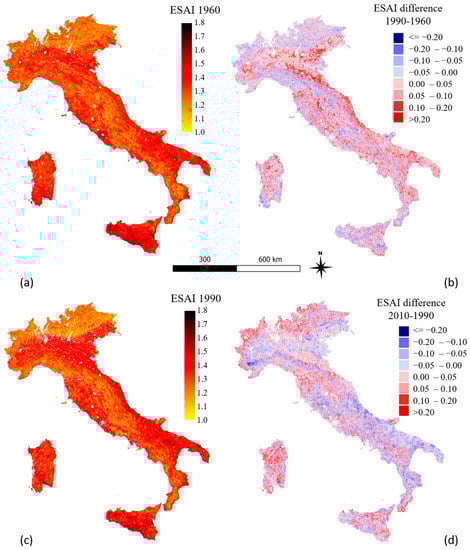
Figure 2.
(a) ESAI, 1960; (b) ESAI change over time, 1960–1990; (c) ESAI, 1990; (d) ESAI change over time, 1990–2010.
Climate quality was estimated taking into account three variables: the average annual rainfall rate, the aridity index, and the slope aspect; all calculated from the Agro-meteorological Database of the Italian Ministry of Agriculture, which has available about 3000 weather stations with daily records since 1951 [79]. The soil layer was regarded as a quite static variable since changes are negligible over 50 years because of the dominance of pedogenesis factors, usually very slow over time. We used a set of standard ESA layers (soil depth, texture, slope, and parent material) from the European Soil Database (Joint Research Centre, JRC) provided at 1 km2 spatial resolution and from ancillary sources: (a) the Italian ‘Map of the water capacity in agricultural soils’ (provided by the Italian Ministry of Agriculture); (b) the Eco-pedological and Geological maps of Italy (realized by JRC and the Italian Geological Service); and (c) a map of Italian land systems realized by the National Centre of Soil Cartography (Florence). The vegetation layer considered four input variables: plant cover, fire risk, erosion protection, and drought resistance. These variables were estimated from reclassification of land cover maps realized on behalf of the CORINE initiative (CLC, see e.g., [80]) for the years 1990 and 2012 and a CORINE-like ‘Topographic and Land Cover Map of Italy’ made available by the National Research Council (CNR) of Italy and the Italian Touring Club (TCI) in 1960 with a hierarchical land system compatible with those of the CORINE Land Cover maps [81]. The land management layer encompasses various indicators considering population dynamics (density and annual growth rate of resident population by the Italian National Institute of Statistics) and agricultural intensification [82], derived from an indicator of land-use intensity based on the sequence of the abovementioned maps [79].
2.3. Local Regressions
To predict spatial variability in the level of land vulnerability to degradation across Italy in light of the ‘convergence’ notion, the empirical results of descriptive statistics and maps were refined with a spatially explicit strategy based on local econometric models, namely geographically weighted regressions (GWRs) run on the percent annual rate of change over time in the level of land vulnerability along the time interval t + 1/t as dependent variable, and the stock variable (level of land vulnerability at time t) as predictor. The implicit spatial structure of both the dependent variable and the lagged variable was considered using a W weighting matrix that computed the linear distance between elementary spatial units. Regressions were estimated separately for each study period (1960–1990 and 1990–2010). A model’s goodness-of-fit was assessed using global R2 coefficients and local slope and intercept coefficients.
The model specification assumes a part of variance not explained by the lagged predictor. The convergence hypothesis is thus tested according with the level of the global R2 and local slopes. High R2 means an indirect verification of the appropriateness of a convergence model for desertification risk in Italy. GWR was adopted in this study with the aim at identifying local-scale variability in desertification risk, using a bi-square nearest neighbor kernel function [83] to calculate weights for the estimation of local models [84]. The methodological framework underlying GWR is similar to that of local regression models; contrary to a spatially implicit ordinary least squares regression (with location invariant regression coefficients), a GWR runs an econometric specification for each location s = 1, …, n, as follows:
where, Y(s) is the dependent variable at location s, X(s) includes the predictors (in our case the ESAI), B(s) includes the regression coefficients, and e(s) is the random error, all at location s. As a result, GWR gave rise to a distribution of local estimated parameters [84].
Y(s) = X(s)B(s) + e(s)
2.4. Software
GWR elaborations and spatial analysis providing simple statistics were carried out in the free, open-source environments of QGIS 3.16.11 and GRASS GIS 7.8.5 (see http://qgis.osgeo.org and https://grass.osgeo.org/, last access on 25 June 2022). In particular, r.gwr-the specific GRASS add-on (https://grass.osgeo.org/grass78/manuals/addons/r.gwr.html (accessed on 25 June 2022)) was adopted to run GWRs on the empirical data available in this work.
3. Results
The empirical results have witnessed a significance dependence structure of the increase (or decrease) in the level of desertification risk with time (see Table 1. As a matter of fact, the outcomes of local regressions (specifically, the global adjusted R2) show a very high path dependence in the first period (1960–1990) and a moderate sign of path dependence in the second period (1990–2010). Regression models show a strong heterogeneity in the local coefficients for both the endogenous processes of land vulnerability represented by the estimated value of the regression intercept and the specific temporal dynamics of convergence (or divergence) expressed through slope coefficients (Figure 3 and Figure 4).

Table 1.
Descriptive statistics of regression models (local slope and intercept coefficients) with the ESAI level at time t as dependent variable in Italy by time interval (AICc = Akaike information criterion; BIC = Bayesian information criterion).
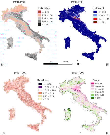
Figure 3.
Regression coefficients and residuals of a GWR model estimating the local variation of land vulnerability to desertification at time t and the same index at time t − 1 for the time intervals 1960–1990: (a) Estimates, (b) Intercept, (c) Residuals, (d) Slope.
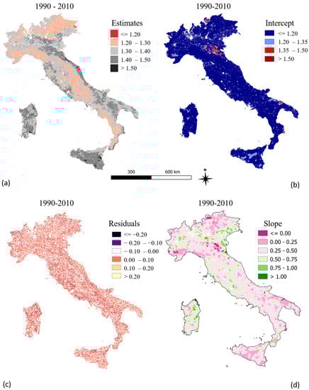
Figure 4.
Regression coefficients and residuals of a GWR model estimating the local variation of land vulnerability to desertification at time t and the same index at time t − 1 for the time intervals 1990–2010: (a) Estimates, (b) Intercept, (c) Residuals, (d) Slope.
Slope coefficients took on very different values in Italy, highlighting different convergence dynamics in the two periods. The first period was characterized, as already highlighted in other works adopting alternative methodologies [66], by a strong polarization along the latitudinal gradient. In other words, Southern regions worsened and Northern regions remained mostly stable. On the contrary, the following period (1990–2010) highlighted a more complex and alarming picture: we observed stability or even an improvement of some areas of Southern Italy and a marked worsening of Northern regions considered as unaffected from a regulatory point of view (NAP).
For instance, a pivotal regional action plan in Northern Italy was initially approved by the Emilia-Romagna regional authority (https://ambiente.regione.emilia-romagna.it/it/acque/approfondimenti/documenti/Sintesi_PAL_def.pdf, last access on 10 August 2022) which, since the 1990s, had experienced more intense climate changes, especially in flat and coastal areas [85]. This has resulted in significant environmental damages and income losses, especially for the agricultural sector, representing a significant part of the regional added value. Losses are concentrated in areas devoted to intensive, high-income agriculture with greater consumption of technical inputs (e.g., water, agrochemicals, mechanization). From this point of view, the most recent convergence phenomena actually underlie a process of territorial polarization, loss of the agronomic quality of soils and, in general, of the ecological quality of landscapes.
This is because, as evidenced with the empirical results of this study, Northern Italy tends towards a counterintuitive polarization, not reflecting the typical north-south gradient, but, on the contrary, developing according to other meso-geographical gradients responding to land-use, population density, or industrial specialization [86]. The results of this work also indicate socioeconomic disparities as having a strong impact on environmental dynamics. The recent evolution, which is strongly linked to the past development path, highlights the intrinsic features of complex local systems, as well as system properties that should be considered when interpreting (and possibly predicting) land degradation dynamics for a refined formulation of multi-scalar policies (Figure 5).
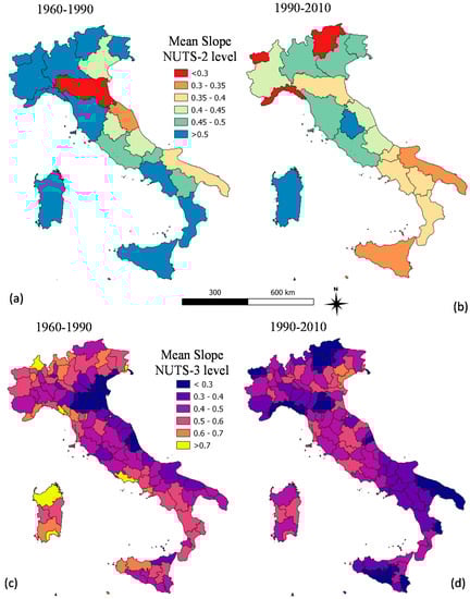
Figure 5.
Results of the regression results (coefficient estimate) comparing NUTS-2 (administrative region) and NUTS-3 (province) scales for the time intervals 1960–1990 (a,c) and 1990–2010 (b,d); NUTS-2 and NUTS-3 are representative of two spatial levels of policy, reflecting the impact of Regional Action Plans (RAPs) and Local Action Plans (LAPs) against desertification in Italy.
A final approach was proposed illustrating a map of the intercept-to-slope ratio derived from the regression results (Figure 6). Higher values of this ratio (deriving from a considerably high value of the intercept and a significantly low value of slope coefficient) indicate a substantial stability of desertification risk, in turn, delineating districts with urgent (and structural) interventions to contain present (and, possible, future) degradation processes. Notably, the most vulnerable areas (ratio > 10) concentrated in the Eastern side of the Po plain (Emilia-Romagna), along the Adriatic Sea coast (Marche and Abruzzo region), Apulia, and Central Sicily. These areas expanded in the second time interval (1990–2010). In other words, the intercept-to-slope ratio may provide visual evidence of the formation (or consolidation) of desertification hotspots in Italy, as associated with high values of the ratio.
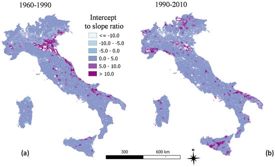
Figure 6.
A map of intercept-to-slope ratios derived from local regression results ((a): 1960–1990; (b): 1990–2010) in Italy.
4. Discussion
The empirical results of our study outline methodological innovation and an original framework that allows discriminating long-term convergence from divergence processes of desertification risk on a local scale, thanks to the spatially explicit analysis of local regression coefficients. In this way, we will be able to capture differentiated socioeconomic dynamics underlying the multiple land degradation processes for Italy. More specifically, local regressions made it possible to outline convergence dynamics in the level of land degradation over time, contributing to the identification of desertification hotspots in a strongly affected country such as Italy. For instance, clusters emerging as priority areas from the intercept-to-slope ratio maps seem to be well-aligned with the dynamics of vegetation productivity and the major sources of information concerning land-use and land-cover changes in Italy. Areas that have the high intercept-to-slope ratio values for the time span 1990–2010 are located prevalently in Apulia, Piedmont, Emilia-Romagna, Sicily, and Liguria. These areas largely correspond to clusters of persistent negative trends in vegetative activity reported by Simoniello et al. [87], i.e., the areas in which the vegetative activity estimated by the satellite time series (NDVI-GIMMS) has shown a tendency to decrease for several consecutive years (1991–2003): see trend and persistence maps provided as Figure S1 in the Supplementary Materials. Moreover, according with field data released by the Italian Institute for Environmental Protection and Research (ISPRA), the Emilia-Romagna and Piedmont regions experienced a sharp urbanization at the expense of agricultural areas between 1990 and 2012, with natural areas remaining stable. Sicily and Liguria showed a decline in natural vegetation because of crop expansion and intensification. Apulia was a peculiar case where sealed areas expanded drastically into rural areas, cropland intensified, and forest areas decreased substantially (see [88] and the report available at https://annuario.isprambiente.it/ada/downreport/html/7037, last accessed on 10 August 2022). Furthermore, as portrayed by the recent literature [89], some Southern Italian regions (namely, Sicily, Sardinia, and Apulia), among the areas most populated by high intercept-to-slope ratio values, are experiencing a considerable temperature increase and precipitation decrease [90,91,92], impacting the most typical cultivations (i.e., vineyards and olive groves, see [93,94]).
In general, areas identified by this study as needing urgent action, only partially correspond to the geography of vulnerability to degradation, as produced by other independent national elaborations (based also on different methodologies) and by the currently available RAPs. This can be explained by considering that, although based on the ESA methodology, our approach captured only zones characterized by a stability of the desertification risk over time through geographically weighted regressions, whereas most of the mentioned elaborations relied on the mere application of the ESA procedure or made use of remote observations.
In particular, at a national scale, a recent study estimating the mean annual land productivity in the period 2000–2015 seems to match better with the intercept-to-slope ratio map relative to the time frame 1960–1990, with the exception of the major islands ([95]). This last map is in good agreement also with the map of sensitivity to desertification and drought in the Mediterranean basin (Figure S2 in Supplementary Materials, see further details at https://esdac.jrc.ec.europa.eu/public_path/shared_folder/projects/DIS4ME/using_dis4me/dismed.htm, last accessed on 25 August 2022) elaborated in 2003 by the EEA (European Environment Agency) and ENEA (Italian National Agency for new Technologies, Energy and Sustainable Economic Development). Proceeding towards the interregional level (Southern Italy), the paper of Imbrenda et al. [96], based on a modified version of the ESA also including remote sensing data (time series 2000–2010), showed an appreciable degree of similarity in the patterns of land vulnerability for Sicily and Campania with respect to the intercept-to-slope ratio map of the time frame 1990–2010.
Lastly, when considering the regional level at which most studies have focused in recent years, we found different levels of similarity between our maps and the regional cartography of degradation (RAPs), even though some areas identified by our procedure emerged as new hotspots. Starting from northern regions, the Piedmont RAP showed a partial overlap of the critical areas with both of the intercept-to-slope ratio maps, as these areas are mainly concentrated within the Po Plain around the major urban centers (see [97]), whereas the Emilia-Romagna RAP showed an appreciable correspondence with the 1960–1990 intercept-to-slope ratio map, identifying as vulnerable those areas located around the highways connecting the major centers of the region [98]. Regions belonging to Central Italy showed a scarce correspondence of critical areas, especially for Tuscany ([99]), whereas coastal areas of the Abruzzo Region were indicated both by the 1960–1990 intercept-to-slope ratio map and the relative RAP (see [100]). Studies concerning the southern regions indicated a large variety of correspondence. The work of Ladisa et al. [101] showed a geography of vulnerability for Apulia that does not match with our findings, neither with the local RAP (see [102]). A similar mismatch occurred for the RAP of Calabria and Basilicata regions (see [103,104]). The findings of the RAP of Basilicata proved to be aligned with other ESA-based studies [105,106]. Lastly, the RAP of Sardinia (see [107]) presented results partially overlapping with our map for the time frame 1990–2010 and with the map derived from an independent work, based on the integration of models and remote sensing data [67]. For Sicily, our 1990–2010 intercept-to-slope ratio map captured a large part of areas, identified as vulnerable by Giordano et al. [108] and by the last Regional Action Programme to fight desertification (see [109]).
At the same time, the results of this approach suggest how analyzing spatially explicit and refined data, such as the lattice constituted of 1 km2 pixels adopted here, allows discrimination of complex processes that should be faced using differentiated tools, policies, and strategies [110]. The outcomes of local regressions additionally provided suitable indicators of convergence/divergence considering the most appropriate spatial scale for elaborating policies, i.e., administrative regions or provinces in Italy (respectively, NUTS-2 or NUTS-3 following European nomenclature of territorial units for official statistics). We have compared the same indicators at sub-regional scales (20 administrative regions and 107 provinces) consistent with the policy objective, i.e., reflecting homogeneous (polygon) areas representing the impact of Regional Action Plans (RAPs) or, eventually, Local Action Plans (LAPs), respectively. This exercise allows us to delineate the evolution of convergence (or divergence) processes characteristic of desertification risk in Italy, in line with the desired political instruments of the NAP.
From a methodological perspective, the novelty of this work lies in the application of a spatially explicit, local regression model to the topic of environmental convergence. This approach has been used for empirical analysis of some environmental variables (e.g., heavy metal accumulation, soil salinity, land use, ecological risk, and ground temperature [111,112,113,114,115]). Few studies have investigated land degradation/desertification issues by means of geographically weighted regressions [116]. In this way, we moved from global regression convergence models (providing homogeneous estimates on a country scale) to local estimation models, providing a spatially explicit result for each elementary unit. In our case, the territorial unit was represented by land pixels extending 1 km2 each. The study area was divided into nearly 300,000 homogeneous pixels in which various factors have been evaluated and the ESAI has been derived at three different times (early-1960s, early-1990s, and early-2010s).
The results of this study are of interest both from a positive and normative point of view. From the former perspective, a statistically refined methodology is applied to an eminently local issue, which has been addressed for a long time with methodologies focusing exclusively (or mostly) on a global scale. At the same time, this approach has also evident regulatory implications, because policies should not be confined to outline country-scale strategies, but they should undertake concrete actions at both regional and local levels. The estimation of a local convergence model for desertification risk makes it possible to provide a significant information asset at a geographical scale of interest for policy, namely, the regional scale (reflecting the impact of regional action plans in Italy). This approach was also valid at the local scale thanks to the availability of a large set of information on homogeneous areas enabling a re-aggregation to the desired administrative scales most suitable for designing policy interventions—as we did in the descriptive analysis involving policy-relevant administrative units (Figure 5).
From this perspective, modeling results are meaningful both at the pixel scale (raster scale covering the whole study area) and at different (polygon) scales, basically reflecting the spatial articulation of administrative levels (NUTS-1, NUTS-2, NUTS-3, and NUTS-5, i.e., from regional to municipal level) representing possible policy targets for future actions to face desertification risk [117]. From an environmental accounting point of view, this system is also relevant because it translates stock use and the withdrawal of natural resources into a spatially explicit information flow. In this sense, the stock of natural resources is represented by the level of land degradation at time zero, assumed as a proxy of the level of land quality at an onset time. Obviously, this does not imply that the Italian landscape was pristine and healthy before the early-1960s; indeed, a massive use of agrochemicals began in parallel with the 1950s economic boom, and urbanization took an extraordinary turn [118,119,120]. In light of such evidence, the proposed model may be generalized to other socioeconomic contexts both in developed and in developing countries [121,122], shedding some further light on the intimate linkage between land degradation and sustainable development [123,124]. As a possible departure from paths of sustainable development, land degradation, especially in Mediterranean areas, reflects the complex interplay between socioeconomic and environmental dimensions [125,126]
5. Conclusions
The empirical results of our study highlight the effectiveness of interpretative models computing on spatially explicit data for complex environmental and socioeconomic issues over a relatively long time frame. They also suggest the importance of local econometric approaches controlling for spatial heterogeneity. In this regard, geographically weighted regressions produce outcomes that provide relevant information to design more effective policy strategies, assuming that local convergence holds—instead of (more traditional) global convergence mechanisms. The case of land vulnerability to degradation in Italy is significant when looking at the genesis of desertification hotspots in the country, namely, areas where risk levels increase rapidly compared with neighboring areas that show stable (or even improved) environmental conditions, because of local factors that are little known or poorly investigated. Capturing these hotspots means being able to concentrate local efforts on environmentally unsustainable areas, adopting the most appropriate mitigation and contrast policies, such as (i) favoring the restoration of abandoned areas, (ii) leveraging the new social demand for farming, and (iii) promoting specific actions to contain peri-urban expansion towards high-quality and fertile soils around metropolitan areas [78,127]. Together with remote sensing and field data, official statistics should directly contribute to this information challenge providing detailed information at an adequately fine-grain spatial resolution. Our approach can be easily generalized to more restricted (or larger) areas, not only in Europe, but also in other parts of the world featuring similar socioeconomic systems. Tools available for these studies are relatively simple and allow for a broad, low-cost application of environmental monitoring techniques in different geographical contexts where desertification risk appears to be an increasingly important issue, having climate change and human-driven landscape transformation as powerful drivers of change.
Supplementary Materials
The following supporting information can be downloaded at: www.mdpi.com/article/10.3390/su141710906/s1, Figure S1. (a) Total persistence map of NDVI (Normalized Difference Vegetation Index) trends for the period 1992-2003 obtained from 8 km GIMMS satellite dataset. The persistence index is expressed in number of years starting from 1992 for which the trend sign of the reference period 1982–1991 is preserved. (b) NDVI Trends of the reference period. (Figure readjusted from Simoniello et al. [87]). Areas of negative persistent trends (magenta) show patterns similar to the intercept-to-slope ratio derived from local regression results (1990–2010). Figure S2. Map of susceptibility to desertification obtained from the ESA procedure (Figure readjusted from https://esdac.jrc.ec.europa.eu/public_path/shared_folder/projects/DIS4ME/using_dis4me/dismed.htm, last accessed on 25 August 2022). The most vulnerable areas show patterns similar to the intercept-to-slope ratio derived from local regression results (1960–1990).
Author Contributions
Conceptualization, L.S. and V.I.; methodology, L.S. and R.C.; software, V.I. and V.D.S.; validation, G.E., T.S. and M.L.; formal analysis, V.I., C.S. and T.S.; investigation, T.S.; resources, M.L.; data curation, M.L.; writing—original draft preparation, V.I. and L.S.; writing—review and editing, V.I., R.C., T.S. and M.L.; visualization, G.E. and V.D.S.; supervision, M.L.; project administration, T.S.; funding acquisition, M.L. All authors have read and agreed to the published version of the manuscript.
Funding
This manuscript was partially funded by the 2014–2020 Rural Development Programme for Basilicata Region (Misura 16.1, PROSIT CUP H86G18000080002) and by the MIUR (Italian Ministry of Education, University and Research), OT4CLIMA PON (National Operational Programme) project. Grant number: ARS01-00405.
Institutional Review Board Statement
Not applicable.
Informed Consent Statement
Not applicable.
Data Availability Statement
The data presented in this study are available on request from the corresponding author.
Conflicts of Interest
The authors declare no conflict of interest.
References
- Barro, R.J.; Sala-i-Martin, X.I. Economic Growth, 2nd ed.; MIT Press: Cambridge, MA, USA, 2003; ISBN 978-0-262-02553-9. [Google Scholar]
- Mukherjee, S.; Kathuria, V. Is economic growth sustainable? Environmental quality of Indian States after 1991. Int. J. Sustain. Dev. 2006, 9, 38–60. [Google Scholar] [CrossRef]
- Chidakel, A.; Child, B. Convergence and Divergence in the Economic Performance of Wildlife Tourism within Multi-Reserve Landscapes. Land Use Policy 2022, 120, 106252. [Google Scholar] [CrossRef]
- Draebing, D.; Eichel, J. Divergence, Convergence, and Path Dependency of Paraglacial Adjustment of Alpine Lateral Moraine Slopes. Land Degrad. Dev. 2018, 29, 1979–1990. [Google Scholar] [CrossRef]
- Stead, D. Convergence, Divergence, or Constancy of Spatial Planning? Connecting Theoretical Concepts with Empirical Evidence from Europe. J. Plan. Lit. 2013, 28, 19–31. [Google Scholar] [CrossRef]
- Tsenkova, S. Planning Trajectories in Post-Socialist Cities: Patterns of Divergence and Change. Urban Res. Pract. 2014, 7, 278–301. [Google Scholar] [CrossRef]
- Bray, M.; Lansbury, R. The Conditions for Convergence: Multinationals, Product Markets, Production Systems and Employment Relations. J. Ind. Relat. 2000, 42, 295–313. [Google Scholar] [CrossRef]
- Gugler, K.; Pfaffermayr, M. Convergence in Structure and Productivity in European Manufacturing? Ger. Econ. Rev. 2004, 5, 61–79. [Google Scholar] [CrossRef]
- Bandt, O.; Herrmann, H.; Parigi, G. Convergence or Divergence in Europe? Springer: Berlin/Heidelberg, Germany, 2006; Volume XIII, ISBN 978-3-540-32611-3. [Google Scholar]
- Buccellato, T.; Corò, G. Relatedness, Economic Complexity and Convergence Across European Regions. In Capitalism, Global Change and Sustainable Development; Springer: Cham, Switzerland, 2020; pp. 149–167. [Google Scholar]
- Dowrick, S.; DeLong, J.B. Globalization and Convergence; National Bureau of Economic Research, Inc.: Cambridge, MA, USA, 2003; pp. 191–226. [Google Scholar]
- Rodrik, D. The Future of Economic Convergence; National Bureau of Economic Research, Inc.: Cambridge, MA, USA, 2011. [Google Scholar]
- Kremer, M.; Willis, J.; You, Y. Converging to Convergence. In NBER Chapters; National Bureau of Economic Research, Inc.: Cambridge, MA, USA, 2021; pp. 337–412. [Google Scholar]
- Baldwin, R.; Martin, P.; Ottaviano, G. Global Income Divergence, Trade, and Industrialization: The Geography of Growth Take-Offs. J. Econ. Growth 2001, 6, 5–37. [Google Scholar] [CrossRef]
- Manduca, R.A. The Contribution of National Income Inequality to Regional Economic Divergence. Soc. Forces 2019, 98, 622–648. [Google Scholar] [CrossRef]
- Mazzola, F.; Pizzuto, P. Resilience and Convergence: Short vs. Long-Run Regional Effects of Economic Crises and Macroeconomic Policies. Sci. Reg. 2020, 19, 431–452. [Google Scholar] [CrossRef]
- Keenan, J.M.; Trump, B.D.; Hynes, W.; Linkov, I. Exploring the Convergence of Resilience Processes and Sustainable Outcomes in Post-COVID, Post-Glasgow Economies. Sustainability 2021, 13, 13415. [Google Scholar] [CrossRef]
- Beenstock, M.; Felsenstein, D. Regional Heterogeneity, Conditional Convergence and Regional Inequality. Reg. Stud. 2008, 42, 475–488. [Google Scholar] [CrossRef]
- Manca, G.; Attaway, D.F.; Waters, N. Program Assessment and the EU’s Agrienvironmental Measure 214: An Investigation of the Spatial Dynamics of Agrienvironmental Policies in Sardinia, Italy. Appl. Geogr. 2014, 50, 24–30. [Google Scholar] [CrossRef]
- Saint-Arnaud, S.; Bernard, P. Convergence or Resilience? A Hierarchical Cluster Analysis of the Welfare Regimes in Advanced Countries. Curr. Sociol. 2003, 51, 499–527. [Google Scholar] [CrossRef]
- Ulucak, R.; Kassouri, Y.; Çağrı İlkay, S.; Altıntaş, H.; Garang, A.P.M. Does Convergence Contribute to Reshaping Sustainable Development Policies? Insights from Sub-Saharan Africa. Ecol. Indic. 2020, 112, 106140. [Google Scholar] [CrossRef]
- Song, M.; Cen, L.; Zheng, Z.; Fisher, R.; Liang, X.; Wang, Y.; Huisingh, D. How Would Big Data Support Societal Development and Environmental Sustainability? Insights and Practices. J. Clean. Prod. 2017, 142, 489–500. [Google Scholar] [CrossRef]
- Thomas, R.J.; Quilleron, E.; Stewart, N. The Rewards of Investing in Sustainable Land Management; Interim Report for the Economics of Land Degradation Initiative: A Global Strategy for Sustainable Land Management; Economics of Land Degradation (ELD) Initiative: Bonn, Germany, 2013. [Google Scholar]
- Lyu, Y.; Shi, P.; Han, G.; Liu, L.; Guo, L.; Hu, X.; Zhang, G. Desertification Control Practices in China. Sustainability 2020, 12, 3258. [Google Scholar] [CrossRef]
- Liang, X.; Li, P.; Wang, J.; Shun Chan, F.K.; Togtokh, C.; Ochir, A.; Davaasuren, D. Research Progress of Desertification and Its Prevention in Mongolia. Sustainability 2021, 13, 6861. [Google Scholar] [CrossRef]
- Peri, P.L.; Rosas, Y.M.; Ladd, B.; Toledo, S.; Lasagno, R.G.; Martínez Pastur, G. Modelling Soil Carbon Content in South Patagonia and Evaluating Changes According to Climate, Vegetation, Desertification and Grazing. Sustainability 2018, 10, 438. [Google Scholar] [CrossRef]
- Tully, K.; Sullivan, C.; Weil, R.; Sanchez, P. The State of Soil Degradation in Sub-Saharan Africa: Baselines, Trajectories, and Solutions. Sustainability 2015, 7, 6523–6552. [Google Scholar] [CrossRef]
- Ewunetu, A.; Simane, B.; Teferi, E.; Zaitchik, B.F. Mapping and Quantifying Comprehensive Land Degradation Status Using Spatial Multicriteria Evaluation Technique in the Headwaters Area of Upper Blue Nile River. Sustainability 2021, 13, 2244. [Google Scholar] [CrossRef]
- Virto, I.; Imaz, M.J.; Fernández-Ugalde, O.; Gartzia-Bengoetxea, N.; Enrique, A.; Bescansa, P. Soil Degradation and Soil Quality in Western Europe: Current Situation and Future Perspectives. Sustainability 2015, 7, 313–365. [Google Scholar] [CrossRef]
- Baumhardt, R.L.; Stewart, B.A.; Sainju, U.M. North American Soil Degradation: Processes, Practices, and Mitigating Strategies. Sustainability 2015, 7, 2936–2960. [Google Scholar] [CrossRef]
- Koch, A.; Chappell, A.; Eyres, M.; Scott, E. Monitor Soil Degradation or Triage for Soil Security? An Australian Challenge. Sustainability 2015, 7, 4870–4892. [Google Scholar] [CrossRef]
- Briassoulis, H. The Socio-Ecological Fit of Human Responses to Environmental Degradation: An Integrated Assessment Methodology. Environ. Manag. 2015, 56, 1448–1466. [Google Scholar] [CrossRef]
- D’Emilio, M.; Coluzzi, R.; Macchiato, M.; Imbrenda, V.; Ragosta, M.; Sabia, S.; Simoniello, T. Satellite Data and Soil Magnetic Susceptibility Measurements for Heavy Metals Monitoring: Findings from Agri Valley (Southern Italy). Environ. Earth Sci. 2018, 77, 63. [Google Scholar] [CrossRef]
- Minaei, M.; Shafizadeh-Moghadam, H.; Tayyebi, A. Spatiotemporal Nexus between the Pattern of Land Degradation and Land Cover Dynamics in Iran. Land Degrad. Dev. 2018, 29, 2854–2863. [Google Scholar] [CrossRef]
- Petrişor, A.-I.; Hamma, W.; Nguyen, H.D.; Randazzo, G.; Muzirafuti, A.; Stan, M.-I.; Tran, V.T.; Aştefănoaiei, R.; Bui, Q.-T.; Vintilă, D.-F.; et al. Degradation of Coastlines under the Pressure of Urbanization and Tourism: Evidence on the Change of Land Systems from Europe, Asia and Africa. Land 2020, 9, 275. [Google Scholar] [CrossRef]
- Bengochea Paz, D.; Henderson, K.; Loreau, M. Agricultural Land Use and the Sustainability of Social-Ecological Systems. Ecol. Model. 2020, 437, 109312. [Google Scholar] [CrossRef]
- Nickayin, S.S.; Salvati, L.; Coluzzi, R.; Lanfredi, M.; Halbac-Cotoara-Zamfir, R.; Salvia, R.; Quaranta, G.; Alhuseen, A.; Gaburova, L. What Happens in the City When Long-Term Urban Expansion and (Un)Sustainable Fringe Development Occur: The Case Study of Rome. ISPRS Int. J. Geo-Inf. 2021, 10, 231. [Google Scholar] [CrossRef]
- Halder, B.; Ameen, A.M.S.; Bandyopadhyay, J.; Khedher, K.M.; Yaseen, Z.M. The Impact of Climate Change on Land Degradation along with Shoreline Migration in Ghoramara Island, India. Phys. Chem. Earth Parts A/B/C 2022, 126, 103135. [Google Scholar] [CrossRef]
- Corona, P. Forestry Research to Support the Transition towards a Bio-Based Economy. Ann. Silvic. Res. 2015, 38, 37–38. [Google Scholar] [CrossRef]
- Kosmas, C.; Karamesouti, M.; Kounalaki, K.; Detsis, V.; Vassiliou, P.; Salvati, L. Land Degradation and Long-Term Changes in Agro-Pastoral Systems: An Empirical Analysis of Ecological Resilience in Asteroussia—Crete (Greece). CATENA 2016, 147, 196–204. [Google Scholar] [CrossRef]
- Mancini, L.D.; Barbati, A.; Corona, P. Geospatial Analysis of Woodland Fire Occurrence and Recurrence in Italy. Ann. Silvic. Res. 2017, 41, 41–47. [Google Scholar] [CrossRef]
- Fares, S.; Bajocco, S.; Salvati, L.; Camarretta, N.; Dupuy, J.-L.; Xanthopoulos, G.; Guijarro, M.; Madrigal, J.; Hernando, C.; Corona, P. Characterizing Potential Wildland Fire Fuel in Live Vegetation in the Mediterranean Region. Ann. For. Sci. 2017, 74, 1–14. [Google Scholar] [CrossRef]
- Salvati, L.; Kosmas, C.; Kairis, O.; Karavitis, C.; Acikalin, S.; Belgacem, A.; Solé-Benet, A.; Chaker, M.; Fassouli, V.; Gokceoglu, C.; et al. Assessing the Effectiveness of Sustainable Land Management Policies for Combating Desertification: A Data Mining Approach. J. Environ. Manag. 2016, 183, 754–762. [Google Scholar] [CrossRef]
- Sietz, D.; Fleskens, L.; Stringer, L.C. Learning from Non-Linear Ecosystem Dynamics Is Vital for Achieving Land Degradation Neutrality. Land Degrad. Dev. 2017, 28, 2308–2314. [Google Scholar] [CrossRef]
- Simoniello, T.; Coluzzi, R.; D’Emilio, M.; Imbrenda, V.; Salvati, L.; Sinisi, R.; Summa, V. Going Conservative or Conventional? Investigating Farm Management Strategies in between Economic and Environmental Sustainability in Southern Italy. Agronomy 2022, 12, 597. [Google Scholar] [CrossRef]
- Galati, A.; Gristina, L.; Crescimanno, M.; Barone, E.; Novara, A. Towards More Efficient Incentives for Agri-Environment Measures in Degraded and Eroded Vineyards. Land Degrad. Dev. 2015, 26, 557–564. [Google Scholar] [CrossRef]
- Brandolini, P.; Pepe, G.; Capolongo, D.; Cappadonia, C.; Cevasco, A.; Conoscenti, C.; Marsico, A.; Vergari, F.; Del Monte, M. Hillslope Degradation in Representative Italian Areas: Just Soil Erosion Risk or Opportunity for Development? Land Degrad. Dev. 2018, 29, 3050–3068. [Google Scholar] [CrossRef]
- Van Leeuwen, C.C.E.; Cammeraat, E.L.H.; de Vente, J.; Boix-Fayos, C. The Evolution of Soil Conservation Policies Targeting Land Abandonment and Soil Erosion in Spain: A Review. Land Use Policy 2019, 83, 174–186. [Google Scholar] [CrossRef]
- Smith, P.; Calvin, K.; Nkem, J.; Campbell, D.; Cherubini, F.; Grassi, G.; Korotkov, V.; Le Hoang, A.; Lwasa, S.; McElwee, P.; et al. Which Practices Co-Deliver Food Security, Climate Change Mitigation and Adaptation, and Combat Land Degradation and Desertification? Glob. Chang. Biol. 2020, 26, 1532–1575. [Google Scholar] [CrossRef] [PubMed]
- Corona, P. The Culture of the Forest. Ann. Silvic. Res. 2022, 47, 54. [Google Scholar] [CrossRef]
- Niedertscheider, M.; Erb, K. Land System Change in Italy from 1884 to 2007: Analysing the North-South Divergence on the Basis of an Integrated Indicator Framework. Land Use Policy 2014, 39, 366–375. [Google Scholar] [CrossRef]
- Berardino, C.; Mauro, G.; Quaglione, D.; Sarra, A. Industrial Districts and Socio-Economic Well-Being: An Investigation on the Italian Provinces Disparities. Soc. Indic. Res. Int. Interdiscip. J. Qual.-Life Meas. 2016, 129, 337–363. [Google Scholar] [CrossRef]
- European Environment Agency. The European Environment—State and Outlook 2020: Knowledge for Transition to a Sustainable Europe; European Environment Agency: Copenhagen, Denmark, 2019.
- Shukla, P.R.; Skea, J.; Calvo Buendia, E.; Masson-Delmotte, V.; Pörtner, H.-O.; Roberts, D.C.; Zhai, P.; Slade, R.; Connors, S.; van Diemen, R.; et al. Special Report on Climate Change and Land—IPCC Site; Intergovernmental Panel on Climate Change (IPCC): Geneva, Switzerland, 2019. [Google Scholar]
- Scholes, R.J.; Montanarella, L.; Brainich, E.; Brainich, E.; Barger, N.; ten Brink, B.; Cantele, M.; Erasmus, B.; Fisher, J.; Gardner, T.; et al. IPBES (2018): Summary for Policymakers of the Assessment Report on Land Degradation and Restoration of the Intergovernmental Science-Policy Platform on Biodiversity and Ecosystem Services; Intergovernmental Science-Policy Platform on Biodiversity and Ecosystem Services: Bonn, Germany, 2018; ISBN 978-3-947851-04-1. [Google Scholar]
- Assennato, F.; Leginio, M.D.; d’Antona, M.; Marinosci, I.; Congedo, L.; Riitano, N.; Luise, A.; Munafò, M. Land Degradation Assessment for Sustainable Soil Management. Ital. J. Agron. 2020, 15, 299–305. [Google Scholar] [CrossRef]
- Basso, F.; Bove, E.; Dumontet, S.; Ferrara, A.; Pisante, M.; Quaranta, G.; Taberner, M. Evaluating Environmental Sensitivity at the Basin Scale through the Use of Geographic Information Systems and Remotely Sensed Data: An Example Covering the Agri Basin (Southern Italy). CATENA 2000, 40, 19–35. [Google Scholar] [CrossRef]
- Afzali, S.F.; Khanamani, A.; Maskooni, E.K.; Berndtsson, R. Quantitative Assessment of Environmental Sensitivity to Desertification Using the Modified MEDALUS Model in a Semiarid Area. Sustainability 2021, 13, 7817. [Google Scholar] [CrossRef]
- Salvati, L.; Zitti, M.; Perini, L. Fifty Years on: Long-Term Patterns of Land Sensitivity to Desertification in Italy. Land Degrad. Dev. 2016, 27, 97–107. [Google Scholar] [CrossRef]
- Lanfredi, M.; Egidi, G.; Bianchini, L.; Salvati, L. One Size Does Not Fit All: A Tale of Polycentric Development and Land Degradation in Italy. Ecol. Econ. 2022, 192, 107256. [Google Scholar] [CrossRef]
- Beck, H.E.; Zimmermann, N.E.; McVicar, T.R.; Vergopolan, N.; Berg, A.; Wood, E.F. Present and Future Köppen-Geiger Climate Classification Maps at 1-Km Resolution. Sci. Data 2018, 5, 180214. [Google Scholar] [CrossRef]
- Lanfredi, M.; Coppola, R.; Simoniello, T.; Coluzzi, R.; Imbrenda, V.; Macchiato, M. Early Identification of Land Degradation Hotspots in Complex Bio-Geographic Regions. Remote Sens. 2015, 7, 8154–8179. [Google Scholar] [CrossRef]
- Salvati, L.; Zitti, M. Regional Convergence of Environmental Variables: Empirical Evidences from Land Degradation. Ecol. Econ. 2008, 68, 162–168. [Google Scholar] [CrossRef]
- Lanfredi, M.; Coluzzi, R.; Imbrenda, V.; Macchiato, M.; Simoniello, T. Analyzing Space–Time Coherence in Precipitation Seasonality across Different European Climates. Remote Sens. 2020, 12, 171. [Google Scholar] [CrossRef]
- Coluzzi, R.; Fascetti, S.; Imbrenda, V.; Italiano, S.S.P.; Ripullone, F.; Lanfredi, M. Exploring the Use of Sentinel-2 Data to Monitor Heterogeneous Effects of Contextual Drought and Heatwaves on Mediterranean Forests. Land 2020, 9, 325. [Google Scholar] [CrossRef]
- Tavares da Costa, R.; Manfreda, S.; Luzzi, V.; Samela, C.; Mazzoli, P.; Castellarin, A.; Bagli, S. A Web Application for Hydrogeomorphic Flood Hazard Mapping. Environ. Model. Softw. 2019, 118, 172–186. [Google Scholar] [CrossRef]
- Santini, M.; Caccamo, G.; Laurenti, A.; Noce, S.; Valentini, R. A Multi-Component GIS Framework for Desertification Risk Assessment by an Integrated Index. Appl. Geogr. 2010, 30, 394–415. [Google Scholar] [CrossRef]
- Nickayin, S.S.; Coluzzi, R.; Marucci, A.; Bianchini, L.; Salvati, L.; Cudlin, P.; Imbrenda, V. Desertification Risk Fuels Spatial Polarization in ‘Affected’ and ‘Unaffected’ Landscapes in Italy. Sci. Rep. 2022, 12, 747. [Google Scholar] [CrossRef]
- Tombolini, I.; Colantoni, A.; Renzi, G.; Sateriano, A.; Sabbi, A.; Morrow, N.; Salvati, L. Lost in Convergence, Found in Vulnerability: A Spatially-Dynamic Model for Desertification Risk Assessment in Mediterranean Agro-Forest Districts. Sci. Total Environ. 2016, 569–570, 973–981. [Google Scholar] [CrossRef]
- Xie, Q.; Dash, J.; Huang, W.; Peng, D.; Qin, Q.; Mortimer, H.; Casa, R.; Pignatti, S.; Laneve, G.; Pascucci, S.; et al. Vegetation Indices Combining the Red and Red-Edge Spectral Information for Leaf Area Index Retrieval. IEEE J. Sel. Top. Appl. Earth Obs. Remote Sens. 2018, 11, 1482–1493. [Google Scholar] [CrossRef]
- Perović, V.; Kadović, R.; Đurđević, V.; Pavlović, D.; Pavlović, M.; Čakmak, D.; Mitrović, M.; Pavlović, P. Major Drivers of Land Degradation Risk in Western Serbia: Current Trends and Future Scenarios. Ecol. Indic. 2021, 123, 107377. [Google Scholar] [CrossRef]
- Rasmy, M.; Gad, A.; Abdelsalam, H.; Siwailam, M. A Dynamic Simulation Model of Desertification in Egypt. Egypt. J. Remote Sens. Space Sci. 2010, 13, 101–111. [Google Scholar] [CrossRef][Green Version]
- Prăvălie, R.; Patriche, C.; Bandoc, G. Quantification of Land Degradation Sensitivity Areas in Southern and Central Southeastern Europe. New Results Based on Improving DISMED Methodology with New Climate Data. CATENA 2017, 158, 309–320. [Google Scholar] [CrossRef]
- Imbrenda, V.; Quaranta, G.; Salvia, R.; Egidi, G.; Salvati, L.; Prokopovà, M.; Coluzzi, R.; Lanfredi, M. Land Degradation and Metropolitan Expansion in a Peri-Urban Environment. Geomat. Nat. Hazards Risk 2021, 12, 1797–1818. [Google Scholar] [CrossRef]
- Lukić, S.; Baumgertel, A.; Obradović, S.; Kadović, R.; Beloica, J.; Pantić, D.; Miljković, P.; Belanović Simić, S. Assessment of Land Sensitivity to Degradation Using MEDALUS Model—A Case Study of Grdelica Gorge and Vranjska Valley (Southeastern Serbia). Iforest-Biogeosciences For. 2022, 15, 163. [Google Scholar] [CrossRef]
- Ait Lamqadem, A.; Pradhan, B.; Saber, H.; Rahimi, A. Desertification sensitivity analysis using MEDALUS model and GIS: A case study of the Oases of Middle Draa Valley, Morocco. Sensors 2018, 18, 2230. [Google Scholar] [CrossRef]
- Saleh, A.; Belal, A.; Jalhoum, M. Quantitative Assessment of Environmental Sensitivity to Desertification in Sidi Abdel-Rahman Area, Northern West Coast of Egypt. Egypt. J. Soil Sci. 2018, 58, 13–26. [Google Scholar] [CrossRef]
- Coluzzi, R.; Bianchini, L.; Egidi, G.; Cudlin, P.; Imbrenda, V.; Salvati, L.; Lanfredi, M. Density Matters? Settlement Expansion and Land Degradation in Peri-Urban and Rural Districts of Italy. Environ. Impact Assess. Rev. 2022, 92, 106703. [Google Scholar] [CrossRef]
- Salvati, L. From Simplicity to Complexity: The Changing Geography of Land Vulnerability to Degradation in Italy. Geogr. Res. 2013, 51, 318–328. [Google Scholar] [CrossRef]
- Büttner, G. CORINE Land Cover and Land Cover Change Products. In Land Use and Land Cover Mapping in Europe: Practices & Trends; Manakos, I., Braun, M., Eds.; Remote Sensing and Digital Image Processing; Springer: Dordrecht, The Netherlands, 2014; pp. 55–74. ISBN 978-94-007-7969-3. [Google Scholar]
- Falcucci, A.; Maiorano, L.; Boitani, L. Changes in Land-Use/Land-Cover Patterns in Italy and Their Implications for Biodiversity Conservation. Landsc. Ecol. 2007, 22, 617–631. [Google Scholar] [CrossRef]
- Otto, R.; Krüsi, B.O.; Kienast, F. Degradation of an Arid Coastal Landscape in Relation to Land Use Changes in Southern Tenerife (Canary Islands). J. Arid Environ. 2007, 70, 527–539. [Google Scholar] [CrossRef]
- Ali, K.; Partridge, M.D.; Olfert, M.R. Can Geographically Weighted Regressions Improve Regional Analysis and Policy Making? Int. Reg. Sci. Rev. 2007, 30, 300–329. [Google Scholar] [CrossRef]
- Fotheringham, A.S.; Brunsdon, C.; Charlton, M.E. Geographically Weighted Regression: A Method for Exploring Spatial Nonstationarity. Geogr. Anal. 1996, 28, 281–298. [Google Scholar] [CrossRef]
- Draghetti, T.; Bortone, G. Emilia-Romagna Water Protection Plan and Climate Change. In Food Security under Water Scarcity in the Middle East: Problems and Solutions; CIHEAM: Bari, Italy, 2005; Volume 65, pp. 171–176. [Google Scholar]
- Salvati, L.; Bajocco, S.; Ceccarelli, T.; Perini, L. Amplifying (or Reversing) the Territorial Disparities in Land Vulnerability to Soil Degradation: The Case of Italy. Prof. Geogr. 2013, 65, 647–663. [Google Scholar] [CrossRef]
- Simoniello, T.; Lanfredi, M.; Liberti, M.; Coppola, R.; Macchiato, M. Estimation of Vegetation Cover Resilience from Satellite Time Series. Hydrol. Earth Syst. Sci. 2008, 12, 1053–1064. [Google Scholar] [CrossRef]
- Tomao, A.; Quatrini, V.; Corona, P.; Ferrara, A.; Lafortezza, R.; Salvati, L. Resilient Landscapes in Mediterranean Urban Areas: Understanding Factors Influencing Forest Trends. Env. Res 2017, 156, 1–9. [Google Scholar] [CrossRef] [PubMed]
- Chelli, S.; Wellstein, C.; Campetella, G.; Canullo, R.; Tonin, R.; Zerbe, S.; Gerdol, R. Climate Change Response of Vegetation across Climatic Zones in Italy. Clim. Res. 2017, 71, 249–262. [Google Scholar] [CrossRef]
- Arnone, E.; Pumo, D.; Viola, F.; Noto, L.V.; La Loggia, G. Rainfall Statistics Changes in Sicily. Hydrol. Earth Syst. Sci. 2013, 17, 2449–2458. [Google Scholar] [CrossRef]
- Caloiero, T.; Guagliardi, I. Temporal Variability of Temperature Extremes in the Sardinia Region (Italy). Hydrology 2020, 7, 55. [Google Scholar] [CrossRef]
- Lionello, P.; Congedi, L.; Reale, M.; Scarascia, L.; Tanzarella, A. Sensitivity of Typical Mediterranean Crops to Past and Future Evolution of Seasonal Temperature and Precipitation in Apulia. Reg. Environ. Chang. 2014, 14, 2025–2038. [Google Scholar] [CrossRef]
- Orlandi, F.; Rojo, J.; Picornell, A.; Oteros, J.; Pérez-Badia, R.; Fornaciari, M. Impact of Climate Change on Olive Crop Production in Italy. Atmosphere 2020, 11, 595. [Google Scholar] [CrossRef]
- Alba, V.; Gentilesco, G.; Tarricone, L. Climate Change in a Typical Apulian Region for Table Grape Production: Spatialisation of Bioclimatic Indices, Classification and Future Scenarios. OENO One 2021, 55, 317–336. [Google Scholar] [CrossRef]
- Sciortino, M.; De Felice, M.; De Cecco, L.; Borfecchia, F. Remote Sensing for Monitoring and Mapping Land Productivity in Italy: A Rapid Assessment Methodology. CATENA 2020, 188, 104375. [Google Scholar] [CrossRef]
- Imbrenda, V.; D’emilio, M.; Lanfredi, M.; Macchiato, M.; Ragosta, M.; Simoniello, T. Indicators for the Estimation of Vulnerability to Land Degradation Derived from Soil Compaction and Vegetation Cover. Eur. J. Soil Sci. 2014, 65, 907–923. [Google Scholar] [CrossRef]
- Regione Piemonte. Progetto Pilota per Contrastare Fenomeni di Siccità e Desertificazione nel Territorio Della Regione Piemonte—Pilot Project to Counter Phenomena of Drought and Desertification in the Territory of the Piedmont Region; Regione Piemonte, Università di Torino, IPLA S.p.A.: Torino, Italy, 2011; p. 146. Available online: https://www.regione.piemonte.it/web/sites/default/files/media/documenti/2018-11/relazione_web2011.pdf (accessed on 5 July 2022).
- Regione Emilia-Romagna. Programma Di Azione Locale (PAL) di Lotta alla Siccità e Desertificazione—Local Action Program (PAL) to Fight Against Drought and Desertification. 2009, p. 20. Available online: https://www.regione.piemonte.it/web/sites/default/files/media/documenti/2018-11/gianni_bianco.pdf (accessed on 5 July 2022).
- Genesio, L.; Magno, R.; Capecchi; Crisci, A.; Bottai, L.; Ferrara, R.; Angeli, L.; Gardin, L. Integrazione dei dati Climatici, Telerilevati e Socio-Economici per la Definizione di Indicatori di Vulnerabilità alla Desertificazione—Integration of Climatic, Remote Sensing and Socio-economic Data for the Definition of Indicators to Desertification Vulnerability (Desertnet Project); Regione Toscana, CNR—Ibimet: Firenze, Italy, 2004; p. 128. Available online: https://www.regione.toscana.it/documents/10180/24000/100d2471bc5b2a61c3d44a929b504d84_librobiancocamclim.pdf/008dbe6b-93de-4e11-8397-7f8bcc698853 (accessed on 5 July 2022).
- Regione Abruzzo; Università di Chieti. Carta Delle Aree Sensibili Alla Desertificazione in Abruzzo—Map of the Areas Sensitive to Desertification in Abruzzo; Regione Abruzzo, Università di Chieti: Chieti, Italy, 2009; Available online: https://annuario.isprambiente.it/ada/downreport/html/7034 (accessed on 5 July 2022).
- Ladisa, G.; Todorovic, M.; Trisorio Liuzzi, G. A GIS-Based Approach for Desertification Risk Assessment in Apulia Region, SE Italy. Phys. Chem. Earth Parts A/B/C 2012, 49, 103–113. [Google Scholar] [CrossRef]
- Montanarella, L.; Paracchini, R.; Russo, E. Programma D’azione per la Lotta Alla Siccità e Alla Desertificazione: Indicazione Delle Aree Vulnerabili in Puglia—Action Program for the Fight to Drought and Desertification: Indication of Vulnerable Areas in Apulia; Regione Puglia, European Soil Bureau, Space Applications Institute: Puglia, Italy, 2008; p. 34. Available online: https://publications.jrc.ec.europa.eu/repository/handle/JRC20288 (accessed on 5 July 2022).
- Regione Calabria, ARPACAL. Carta Delle Aree Sensibili Alla Desertificazione Calabria—Map of the Areas Sensitive to Desertification Calabria; ARPACAL: Regione Calabria, Italy, 2004. Available online: https://www.isprambiente.gov.it/files/pubblicazioni/pubblicazionidipregio/suolo-radice/106-118.pdf (accessed on 5 July 2022).
- Ferrara, A.; Belotti, A.; Faretta, S.; Mancino, G. Carta Delle Aree Sensibili Alla Desertificazione Della Regione Basilicata—Map of the Areas Sensitive to Desertification of the Basilicata Region; 2005. Available online: https://foresta.sisef.org/pdf/?id=efor0255-0020066 (accessed on 5 July 2022).
- Imbrenda, V.; D’Emilio, M.; Lanfredi, M.; Ragosta, M.; Simoniello, T. Indicators of Land Degradation Vulnerability Due to Anthropic Factors: Tools for an Efficient Planning. Available online: https://www.igi-global.com/chapter/indicators-of-land-degradation-vulnerability-due-to-anthropic-factors/www.igi-global.com/chapter/indicators-of-land-degradation-vulnerability-due-to-anthropic-factors/95002 (accessed on 25 August 2022).
- Gabriele, M.; Brumana, R.; Previtali, M.; Cazzani, A. A Combined GIS and Remote Sensing Approach for Monitoring Climate Change-Related Land Degradation to Support Landscape Preservation and Planning Tools: The Basilicata Case Study. Appl. Geomat. 2022. [Google Scholar] [CrossRef]
- Motroni, A.; Canu, S.; Bianco, G.; Loj, G. Carta Delle Aree Sensibili Alla Desertificazione, Regione Sardegna—Environmentally Sensitive Areas—ESAs, Sardinia Region (DesertNet Project). 2004, p. 46. Available online: http://www.sar.sardegna.it/pubblicazioni/miscellanea/desertificazione/desertificazione.pdf (accessed on 5 July 2022).
- Giordano, L.; Giordano, F.; Grauso, S.; Iannetta, M.; Rossi, L.; Sciortino, M.; Bonati, G. Carta Delle Aree Sensibili Alla Desertificazione Sicilia—Map of Areas Sensitive to Desertification in Sicily; Regione Sicilia, ENEA: Roma, Italy, 2002; Available online: https://www.researchgate.net/publication/237574635_Identification_of_areas_sensitive_to_desertification_in_Sicily_Region (accessed on 5 July 2022).
- Regione Sicilia, Autorità di Bacino del Distretto Idrografico della Sicilia. Strategia Regionale di Azione per la Lotta Alla Desertificazione in Sicilia—Regional Action Strategy to Combat Desertification in Sicily. 2019, p. 119. Available online: https://pti.regione.sicilia.it/portal/page/portal/PIR_PORTALE/PIR_LaStrutturaRegionale/PIR_PresidenzadellaRegione/PIR_AutoritaBacino/PIR_Areetematiche/PIR_sitiTematici/PIR_Desertificazione/Strategia%2Bregionale%2Blotta%2Bdesertificazione_def_0.pdf (accessed on 5 July 2022).
- Costantini, E.A.C.; Urbano, F.; Aramini, G.; Barbetti, R.; Bellino, F.; Bocci, M.; Bonati, G.; Fais, A.; L’Abate, G.; Loj, G.; et al. Rationale and Methods for Compiling an Atlas of Desertification in Italy. Land Degrad. Dev. 2009, 20, 261–276. [Google Scholar] [CrossRef]
- Chen, Z.; Zhang, S.; Geng, W.; Ding, Y.; Jiang, X. Use of Geographically Weighted Regression (GWR) to Reveal Spatially Varying Relationships between Cd Accumulation and Soil Properties at Field Scale. Land 2022, 11, 635. [Google Scholar] [CrossRef]
- Nie, S.; Bian, J.; Zhou, Y. Estimating the Spatial Distribution of Soil Salinity with Geographically Weighted Regression Kriging and Its Relationship to Groundwater in the Western Jilin Irrigation Area, Northeast China. Pol. J. Environ. Stud. 2020, 30, 283–294. [Google Scholar] [CrossRef]
- Punzo, G.; Castellano, R.; Bruno, E. Using Geographically Weighted Regressions to Explore Spatial Heterogeneity of Land Use Influencing Factors in Campania (Southern Italy). Land Use Policy 2022, 112, 105853. [Google Scholar] [CrossRef]
- Yu, T.; Bao, A.; Xu, W.; Guo, H.; Jiang, L.; Zheng, G.; Yuan, Y.; Nzabarinda, V. Exploring Variability in Landscape Ecological Risk and Quantifying Its Driving Factors in the Amu Darya Delta. Int. J. Environ. Res. Public Health 2020, 17, 79. [Google Scholar] [CrossRef] [PubMed]
- Zhao, R.; Yao, M.; Yang, L.; Qi, H.; Meng, X.; Zhou, F. Using Geographically Weighted Regression to Predict the Spatial Distribution of Frozen Ground Temperature: A Case in the Qinghai—Tibet Plateau. Environ. Res. Lett. 2021, 16, 024003. [Google Scholar] [CrossRef]
- Ding, J.; Chen, Y.; Wang, X.; Cao, M. Land Degradation Sensitivity Assessment and Convergence Analysis in Korla of Xinjiang, China. J. Arid Land 2020, 12, 594–608. [Google Scholar] [CrossRef]
- Sarkodie, S.A.; Strezov, V. A Review on Environmental Kuznets Curve Hypothesis Using Bibliometric and Meta-Analysis. Sci. Total Environ. 2019, 649, 128–145. [Google Scholar] [CrossRef] [PubMed]
- Carlucci, M.; Salvia, R.; Quaranta, G.; Salvati, L.; Imbrenda, V. Official Statistics, Spatio-Temporal Dynamics and Local-Scale Monitoring: Toward Integrated Environmental-Economic Accounting for Land Degradation. Lett. Spat. Resour. Sci. 2022. [Google Scholar] [CrossRef]
- Fauri, F. The “Economic Miracle” and Italy’s Chemical Industry, 1950—1965: A Missed Opportunity. Enterp. Soc. 2000, 1, 279–314. [Google Scholar] [CrossRef]
- Dematteis, G. Urbanization and Counter—Urbanization in Italy. Ekistics 1986, 53, 26–33. [Google Scholar]
- Barbero-Sierra, C.; Marques, M.J.; Ruíz-Pérez, M.; Bienes, R.; Cruz-Maceín, J.L. Farmer Knowledge, Perception and Management of Soils in the Las Vegas Agricultural District, Madrid, Spain. Soil Use Manag. 2016, 32, 446–454. [Google Scholar] [CrossRef]
- Ferrara, A.; Kosmas, C.; Salvati, L.; Padula, A.; Mancino, G.; Nolè, A. Updating the MEDALUS-ESA Framework for Worldwide Land Degradation and Desertification Assessment. Land Degrad. Dev. 2020, 31, 1593–1607. [Google Scholar] [CrossRef]
- Amiraslani, F.; Dragovich, D. Combating Desertification in Iran over the Last 50 Years: An Overview of Changing Approaches. J. Environ. Manag. 2011, 92, 1–13. [Google Scholar] [CrossRef]
- Bestelmeyer, B.T.; Okin, G.S.; Duniway, M.C.; Archer, S.R.; Sayre, N.F.; Williamson, J.C.; Herrick, J.E. Desertification, Land Use, and the Transformation of Global Drylands. Front. Ecol. Environ. 2015, 13, 28–36. [Google Scholar] [CrossRef]
- Juntti, M.; Wilson, G.A. Conceptualizing Desertification in Southern Europe: Stakeholder Interpretations and Multiple Policy Agendas. Eur. Environ. 2005, 15, 228–249. [Google Scholar] [CrossRef]
- Ibáñez, J.; Valderrama, J.M.; Puigdefábregas, J. Assessing Desertification Risk Using System Stability Condition Analysis. Ecol. Model. 2008, 213, 180–190. [Google Scholar] [CrossRef]
- Spataru, A.; Faggian, R.; Docking, A. Principles of Multifunctional Agriculture for Supporting Agriculture in Metropolitan Peri-Urban Areas: The Case of Greater Melbourne, Australia. J. Rural Stud. 2020, 74, 34–44. [Google Scholar] [CrossRef]


Publisher’s Note: MDPI stays neutral with regard to jurisdictional claims in published maps and institutional affiliations. |
© 2022 by the authors. Licensee MDPI, Basel, Switzerland. This article is an open access article distributed under the terms and conditions of the Creative Commons Attribution (CC BY) license (https://creativecommons.org/licenses/by/4.0/).