


Landscape Archaeology of Southern Mesopotamia: Identifying Features in the Dried Marshes


Abstract
:1. Introduction
2. Methods
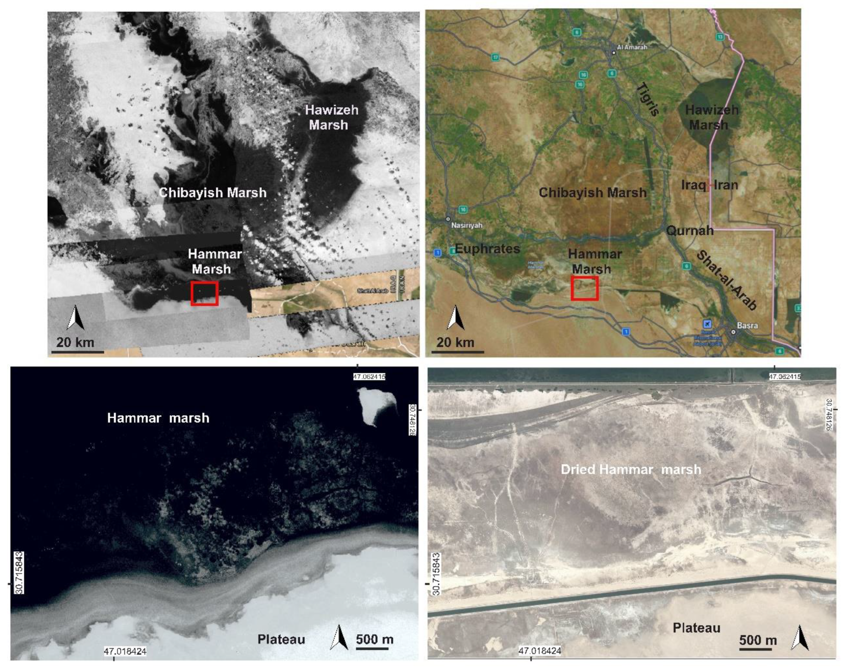
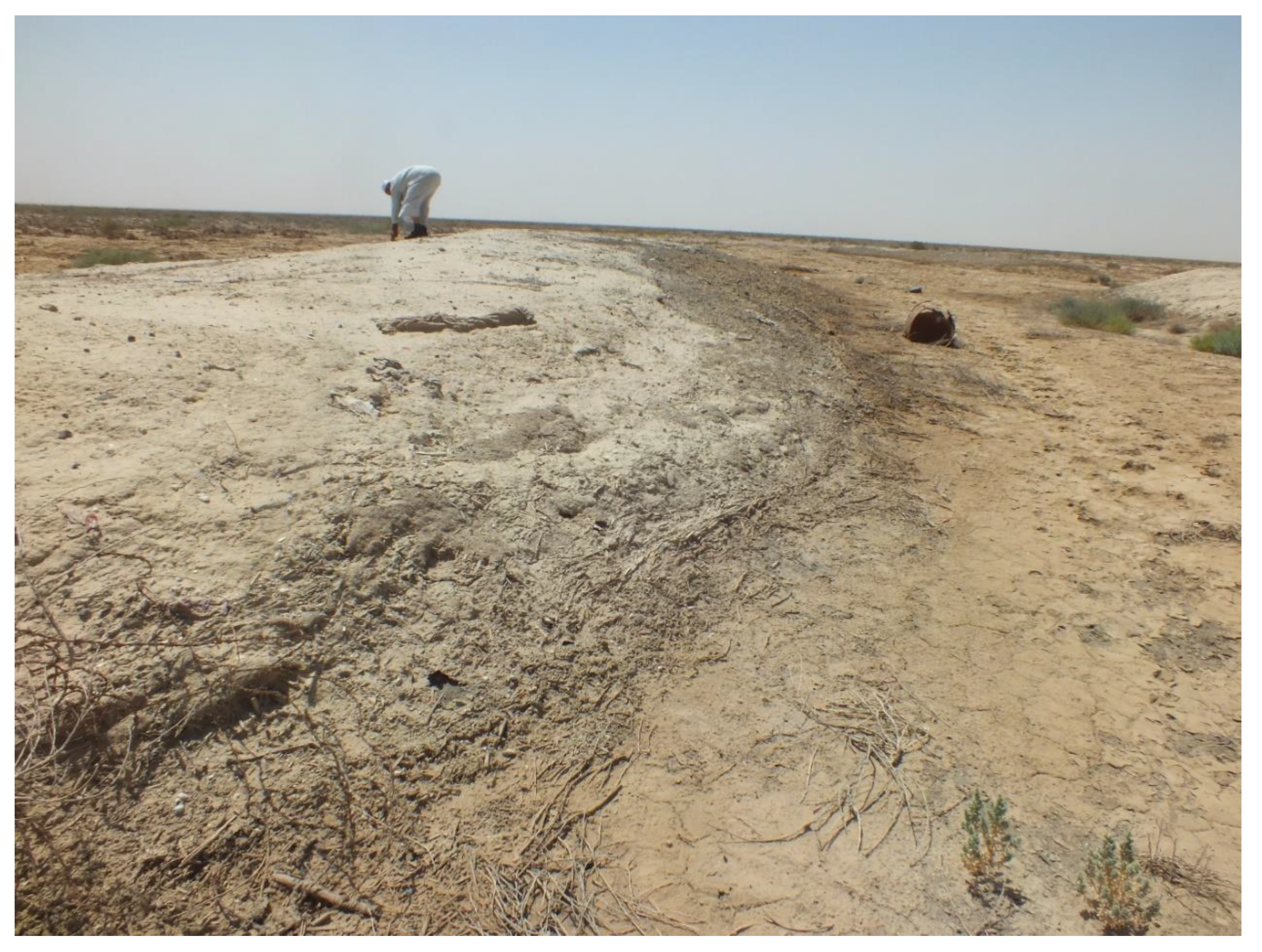
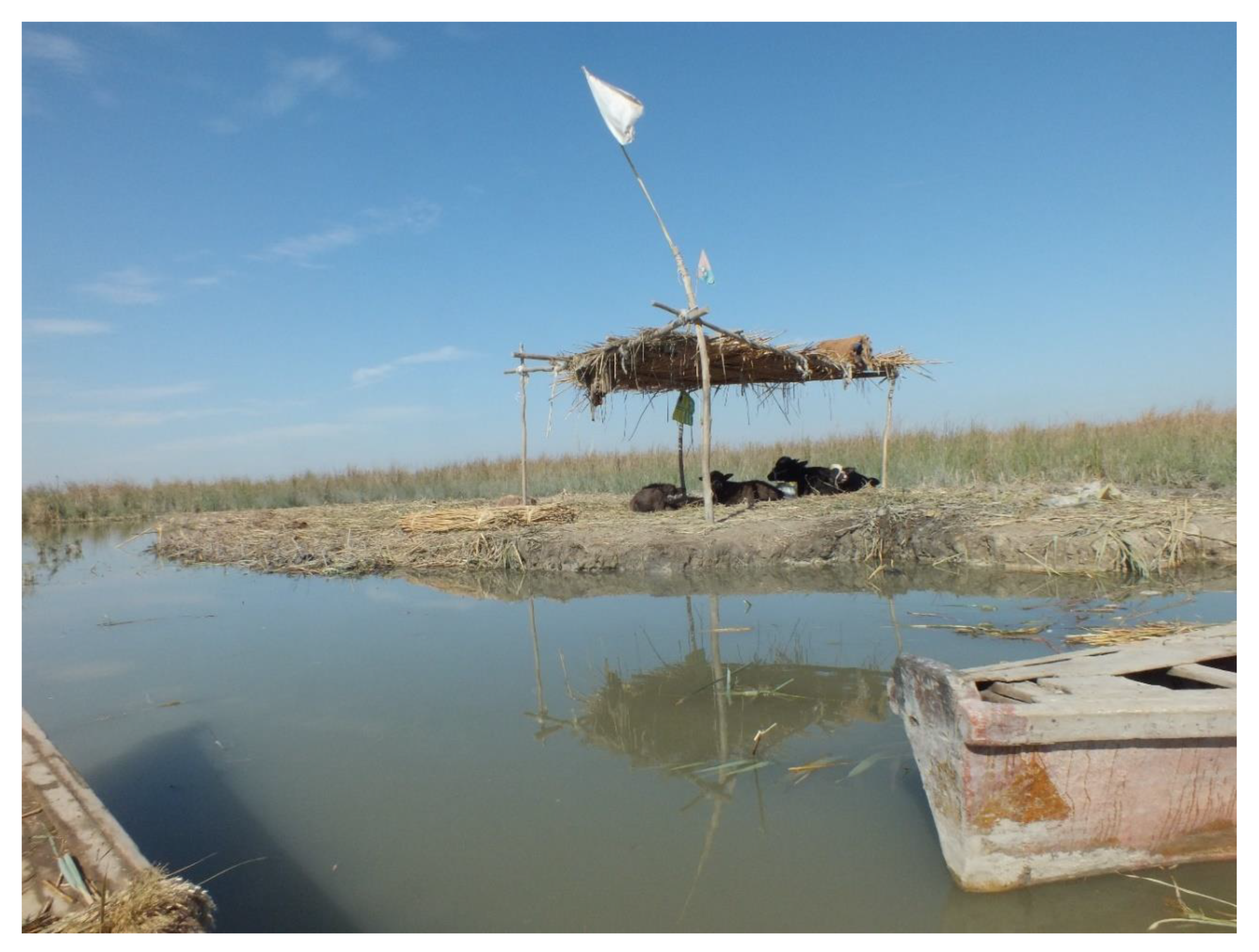
3. Results
3.1. Settlement Sites
3.1.1. The Large Settlement Sites
3.1.2. The Small Settlement Sites
3.2. Rivers
3.3. Canals
3.4. Farms
3.5. Grooves
3.6. Roads (Hollow Ways)
4. Discussion
5. Conclusions
Author Contributions
Funding
Acknowledgments
Conflicts of Interest
References
- Jotheri, J.; Altaweel, M.; Tuji, A.; Anma, R.; Pennington, B.; Rost, S.; Watanabe, C. Holocene fluvial and anthropogenic processes in the region of Uruk in southern Mesopotamia. Quat. Int. 2018, 483, 57–69. [Google Scholar] [CrossRef]
- Pournelle, J.R. Marshland of Cities: Deltaic Landscape and Evolution of Early Mesopotamian Civilization. Unpublished Ph.D. Thesis, University of California, San Diego, CA, USA, 2003. [Google Scholar]
- Al-Dafar, A. Shadow States: The Archaeology of Power in the Marshes of Southern Mesopotamia. Ph.D. Thesis, University of Stony Brook, New York, NY, USA, 2015. [Google Scholar]
- Richardson, C.J.; Hussain, N.A. Restoring the Garden of Eden: An ecological assessment of the marshes of Iraq. BioScience 2006, 56, 477–489. [Google Scholar] [CrossRef]
- Priestley, C. “We Won’t Survive in a City. The Marshes are Our Life”: An Analysis of Ecologically Induced Genocide in the Iraqi Marshes. J. Genocide Res. 2021, 23, 279–301. [Google Scholar] [CrossRef]
- Al-Hamdani, A. Kingdom of Reeds: The Archaeological Heritage of Southern Iraqi Marshes. Am. Acad. Res. Inst. Iraq Newsl. 2014, 9, 15–20. [Google Scholar]
- Jotheri, J.; de Gruchy, M.W.; Almaliki, R.; Feadha, M. Remote sensing the archaeological traces of boat movement in the marshes of Southern Mesopotamia. Remote Sens. 2019, 11, 2474. [Google Scholar] [CrossRef]
- Hritz, C.; Al-Hawi, N.D.; Al-Sudani, K.J.; Albadran, B.N.; Pournelle, J.R. Resilient Landscapes: The Evolution of Riparian Landscape Studies in Southern Iraq. In New Agendas in Remote Sensing and Landscape Archaeology in the Near East; Archaeopress: Oxford, UK, 2020; p. 228. [Google Scholar]
- Cowley, D.; Verhoeven, G.; Traviglia, A. Editorial for Special Issue: “Archaeological Remote Sensing in the 21st Century:(Re) Defining Practice and Theory”. Remote Sens. 2021, 13, 1431. [Google Scholar] [CrossRef]
- Cowley, D.; Banaszek, Ł.; Geddes, G.; Gannon, A.; Middleton, M.; Millican, K. Making LiGHT work of large area survey? Developing approaches to rapid archaeological mapping and the creation of systematic national-scaled heritage data. J. Comput. Appl. Archaeol. 2020, 3, 109–121. [Google Scholar] [CrossRef]
- Ur, J. Spying on the past: Declassified intelligence satellite photographs and near eastern landscapes. Near East. Archaeol. 2013, 76, 28–36. [Google Scholar] [CrossRef]
- Hammer, E.; Ur, J. Near eastern landscapes and declassified U2 aerial imagery. Adv. Archaeol. Pract. 2019, 7, 107–126. [Google Scholar] [CrossRef]
- Soroush, M.; Mehrtash, A.; Khazraee, E.; Ur, J.A. Deep learning in archaeological remote sensing: Automated qanat detection in the Kurdistan region of Iraq. Remote Sens. 2020, 12, 500. [Google Scholar] [CrossRef]
- Hammer, E.; FitzPatrick, M.; Ur, J. Succeeding CORONA: Declassified HEXAGON intelligence imagery for archaeological and historical research. Antiquity 2022, 96, 679–695. [Google Scholar] [CrossRef]
- Altaweel, M.; Khelifi, A.; Li, Z.; Squitieri, A.; Basmaji, T.; Ghazal, M. Automated Archaeological Feature Detection Using Deep Learning on Optical UAV Imagery: Preliminary Results. Remote Sens. 2022, 14, 553. [Google Scholar] [CrossRef]
- Karavanova, E.I.; Shrestha, D.P.; Orlov, D.S. Application of remote sensing techniques for the study of soil salinity in semi-arid Uzbekistan. In Responses to Land Degradation; Oxford and IBH Publishing Co. Pvt. Ltd: New Delhi, India, 2001; pp. 261–273. [Google Scholar]
- Palacios-Orueta, A.; Ustin, S.L. Remote sensing of soil properties in the Santa Monica Mountains I. Spectral analysis. Remote Sens. Environ. 1998, 65, 170–183. [Google Scholar] [CrossRef]
- Jotheri, J. The Environment and Landscape Archaeology of the Abu Tbeirah Region. In Abu Tbeirah: Excavations I. Area 1. Last Phase and Building A—Phase 1; Romano, L., D’Agostino, F., Eds.; Sapienza Università Editrice: Rome, Italy, 2019; pp. 49–53. [Google Scholar]
- de Gruchy, M.; Jotheri, J.; Alqaragholi, H.; Al-Janabi, J.; Alabdan, R.; Al-Talaqani, H.; Almamouri, G.; Al-Rubaye, H. The Khandaq Shapur: Defense, Irrigation, Boundary, Frontier. Land 2021, 10, 1017. [Google Scholar] [CrossRef]
- Ur, J. CORONA satellite photography and ancient road networks: A northern Mesopotamian case study. Antiquity 2003, 77, 102–115. [Google Scholar] [CrossRef]
- Wilkinson, T.J. Linear hollows in the Jazira, upper Mesopotamia. Antiquity 1993, 67, 548–562. [Google Scholar] [CrossRef]
- Iacobucci, G.; Troiani, F.; Milli, F.; Nadali, D. Geomorphology of the lower Mesopotamian plain at Tell Zurghul archaeological site. J. Maps 2022. [Google Scholar] [CrossRef]
- Forti, L.; Romano, L.; Celant, A.; D’Agostino, F.; Di Rita, F.; Jotheri, J.; Magri, D.; Mazzini, I.; Tentori, D.; Milli, S. The paleoenvironment and depositional context of the Sumerian site of Abu Tbeirah (Nasiriyah, southern Mesopotamia, Iraq). Quat. Res. 2022, 1–19. [Google Scholar] [CrossRef]


Publisher’s Note: MDPI stays neutral with regard to jurisdictional claims in published maps and institutional affiliations. |
© 2022 by the authors. Licensee MDPI, Basel, Switzerland. This article is an open access article distributed under the terms and conditions of the Creative Commons Attribution (CC BY) license (https://creativecommons.org/licenses/by/4.0/).
Share and Cite
Jotheri, J.; Feadha, M.; Al-Janabi, J.; Alabdan, R. Landscape Archaeology of Southern Mesopotamia: Identifying Features in the Dried Marshes. Sustainability 2022, 14, 10961. https://doi.org/10.3390/su141710961
Jotheri J, Feadha M, Al-Janabi J, Alabdan R. Landscape Archaeology of Southern Mesopotamia: Identifying Features in the Dried Marshes. Sustainability. 2022; 14(17):10961. https://doi.org/10.3390/su141710961
Chicago/Turabian StyleJotheri, Jaafar, Malath Feadha, Jassim Al-Janabi, and Raheem Alabdan. 2022. "Landscape Archaeology of Southern Mesopotamia: Identifying Features in the Dried Marshes" Sustainability 14, no. 17: 10961. https://doi.org/10.3390/su141710961
APA StyleJotheri, J., Feadha, M., Al-Janabi, J., & Alabdan, R. (2022). Landscape Archaeology of Southern Mesopotamia: Identifying Features in the Dried Marshes. Sustainability, 14(17), 10961. https://doi.org/10.3390/su141710961