Article

Spatial Analysis for the Landscape Visual Aesthetic Quality of Urban Residential Districts Based on 3D City Modeling

1
Department of Environmental Design, Fine Arts Academy, Hunan Normal University, No. 36 Rushan Road, Yuelu District, Changsha 410081, China
2
College of Geographic Science, Hunan Normal University, No. 36 Rushan Road, Yuelu District, Changsha 410081, China
*
Author to whom correspondence should be addressed.
Sustainability 2022, 14(18), 11500; https://doi.org/10.3390/su141811500
Submission received: 5 August 2022 / Revised: 7 September 2022 / Accepted: 12 September 2022 / Published: 14 September 2022
(This article belongs to the Section Sustainable Urban and Rural Development)

Abstract

:
The landscape visual aesthetic quality (LVAQ) of urban residential districts is an important index for measuring urban livability and is a tripartite concern among urban managers, real estate developers and residents. The LVAQ of residential districts is determined by their visual openness and the aesthetic degree of the surrounding landscape, a value combining subjective evaluation and objective analysis. Although existing studies have carried out empirical analyses on the LVAQ of residential districts and have summarized some influencing factors, they have largely overlooked the specific impact and interactions of various factors, failing to establish 3D city models meeting LVAQ analysis requirements and falling short in developing appropriate evaluation approaches suitable for whole city scale. In this study, we propose a spatial simulation analysis for the LVAQ of residential districts based on 3D city modeling, aesthetic evaluation and viewshed analysis. In order to improve the accuracy of the study, we collected massive RS data and established a 3D city model covering a large amount of architecture and landscape information. We analyzed three representative cases and calculated the LVAQ of 1258 residential districts in Changsha City, Hunan, China, evaluating the results with various construction and planning indicators. Our results show that the LVAQ of residential districts is affected by their own construction conditions and the surrounding districts and landscape areas. Various architectural and planning indicators have restrictive and direct effects on LVAQ. Optimizing the layout of landscape areas and the construction mode of residential districts through urban planning and urban renewal may help improve their LVAQ. This study helps better understand the general principles that affect the LVAQ of residential districts and supports the development of urban scale LVAQ analysis methods for residential districts. The findings are expected to provide methodological support for the landscape analysis and evaluation of urban residential districts in China and other developing countries and provide optimization ideas for urban human settlement environment sustainability.

1. Introduction

The landscape visual aesthetic quality (LVAQ) of urban residential districts is an important topic in human settlement environment research and is crucial in contemporary urban planning [1,2]. The term “aesthetic” refers to people’s appreciative understanding of the object being viewed or perceived, including the viewer’s subjective aesthetic judgment and the objective and social aesthetic paradigm [3]. In the conceptual system of aesthetics, the aesthetic quality and the visual aesthetic quality are two important components. The former refers to people’s subjective and objective evaluation of all kinds of perceptible aesthetic objects (such as painting, music and dance); the latter refers to people’s subjective and objective evaluation of viewable objects (such as sculpture, landscape and architecture) [4]. Urban landscape is an important viewable object that affects people’s judgment on the quality of urban aesthetics and directly relates to the urban living environment and the quality of residents’ life [5]. According to “Caring for the Earth: A Strategy for Sustainable Living”, published by the International Union for Conservation of Nature (INCN) and other organizations in 1991, improving people’s living quality, especially the living environment, is essential for sustainable development [6]. Among all kinds of urban areas, the residential district is the most closely related to the living environment. Therefore, the visual aesthetic quality of residential districts plays an important role in the visual aesthetic quality of the urban living environment [7].
The visual aesthetic quality of residential districts mainly includes two aspects: building visual aesthetic quality and the landscape visual aesthetic quality. Building visual aesthetic quality is related to the style, volume and color of buildings, including not only the modeling aesthetic elements such as balance, rhythm, regionalism and symbolism but also the functional aesthetic elements such as technology, practicality and publicity. The building visual aesthetic quality is determined by the principles of formal beauty and the needs and preferences of users, which is difficult to quantify [8]. In comparison, landscape visual aesthetic quality is determined by the visibility of the surrounding landscape and its aesthetic degree, comprising visibility elements such as the horizontal visual field, the vertical visual field, the degree of occlusion and the distance between the landscape area and the observation subject, as well as the scale, coordination, richness, culture and vegetation coverage of the observed subject (landscape area and green space) [9]. Compared with the building visual aesthetic quality, the landscape visual aesthetic quality is a combination of subjective and objective concepts, which can be evaluated through quantitative analysis [10]. Under this background, the study on the landscape visual aesthetic quality of urban residential districts is helpful to grasp various factors that affect the landscape visual aesthetic quality, providing a useful reference for optimizing the urban living environment and helping to improve the sustainability of urban development.
Due to the acceleration of urbanization, a large number of new residential districts have been built inside cities in many developing countries [11]. To generate more economic benefits, these residential districts create more sales areas by introducing plot improvements and attracting more consumers by improving the LVAQ [12]. Given the importance of visual aesthetics, LVAQ research has increased over the years. Some studies have expounded on the importance and value of the LVAQ, highlighting the critical role of the LVAQ in affecting real estate prices, urban landscape effects and development quality [13]. Low LVAQ values are not only unattractive to residents but also negatively impact the urban area’s environment and even the city’s overall appearance. The aesthetic degree of the surrounding landscape determines the landscape visual aesthetic quality, which is the core factor of the LVAQ [14]. High-quality large-area green spaces can improve the landscape inside and outside the residential district, effectively improving the LVAQ. The building density of the residential district and its surrounding areas can affect its visual field, influencing the visibility of the surrounding landscape [15]. The architectural form and layout can also have a significant impact on the visual field of residential buildings, causing a restrictive impact on the LVAQ [16].
Other studies have explored measures to improve the LVAQ of residential districts and the surrounding green spaces to increase the landscape quality of nearby residential districts [17]. Some have recommended increasing the building height and changing the building layout to expand the viewshed of residential districts, and others have suggested creating more artificial landscapes to enhance people’s interest [18]. Many of these measures have been implemented in many cities in China. However, they do not always achieve the intended results; some have even backfired. For example, to have better viewsheds, several neighboring residential districts have increased the building height, but this has led to mutual blocking, resulting in severely restricted viewsheds [19]. Another example is when a residential district developed numerous surrounding artificial landscapes, which were considered “ugly” by the residents and further reduced the LVAQ [20]. Therefore, spatial simulation analyses may be necessary to accurately evaluate and characterize the LVAQ of urban residential districts and determine the factors and principles affecting LVAQ.
The use of 3D city models has become an integral instrument in the study of the LVAQ of urban residential districts [21]. By analyzing and calculating the field of vision, sight distance and the visual scenery of residential districts in 3D city models, the LVAQ of residential and other urban districts can be quantified [22]. There are a number of computer software and mobile applications providing sample 3D city models. For example, Google Earth Pro has some available 3D city models. However, many of them have only parts of buildings with 3D models, whereas other cities have no 3D models at all [23]. Some open GIS platforms, such as ArcGIS City Engine and City Builder, provide complete 3D models for some cities but only account for a small part of 13,800 cities in the world [24]. Currently, 3D city modeling largely depends on manual construction, which can be laborious, tedious and time-consuming. The use of scanning technology, such as unmanned aerial vehicles (UAVs), may offer an effective alternative to providing new information and accelerating the construction of these 3D models [25]. Adding the outline and scope of the landscape area and the 3D terrain in the 3D city model can be extremely useful in LVAQ research [26].
The key to accurate LVAQ analysis is establishing a system that is able to coordinate the various influencing factors and corresponding correlations [27]. Although traditional 2D visibility analyses are simple to operate, they ignore 3D elements such as terrain fluctuations, building heights and vertical field of view, significantly limiting their accuracy [28]. For example, a 3-story building and a 30-story building have very different visual fields and occlusion, but these disparities are difficult to reflect in 2D visibility analysis [29]. Recent 3D visibility analysis can comprehensively calculate the visibility and aesthetic score of various sceneries and evaluate the LVAQ [30]. Spatial–visual landscape mapping methods (e.g., compartment, grid cell and eye-tracking analyses) can be used to analyze the LVAQ of landscape architecture in terms of visual frequency, gaze direction, eye level, continuity and complexity [31]. Particularly in 3D urban street mapping, the volume of visible space and openness of any viewpoint can be measured by constructing and analyzing the sectors of sight [32]. However, because it requires collecting more data and performing a huge number of calculations, this approach is currently applied only to small city parks and blocks [33]. The GIS-based viewshed analysis is applicable to larger research scopes, which can obtain the distribution and spatial differences of landscape visibility by analyzing visual components, landscape priority, closure degree and visual interactions [34]. However, most studies in this field adopt a macro-level approach, use the urban block or district as the research unit, and largely overlook micro-elements, such as differences between building units, landscape corridor forms, human vision and sight distances [35]. However, for urban planners and decision makers, it is not enough to explore the LVAQ of individual residential districts or analyze the macro-level but use inaccurate residential district data [36].
Although much research has been conducted on the definition, connotation, influencing factors and optimization measures for the LVAQ in urban residential districts, several unresolved issues remain. First, although the influencing factors of the LVAQ have been summarized, the interactions between factors have not been thoroughly explored. Second, existing 3D city models fail to meet the requirements of the LVAQ analysis of residential districts in terms of accuracy and information; a more detailed and comprehensive 3D city model is needed. Third, among the existing visibility analyses, macro-level methods can only analyze the general differences of the LVAQ in the city and often lack the required precision. Micro-level approaches can more accurately analyze the LVAQ of a single residential district, but many cannot bear the huge data volume required for whole city assessments.
To address these problems, using representative case analysis, we established an objective and straightforward approach that provides the LVAQ of urban residential districts. This approach is divided into four steps. First, a 3D city model is established, using 3D elements such as architecture, landscape and terrain for analysis. Second, the viewsheds of the observation unit (including the building and ground units) in the residential district are established, and the viewsheds of the entire district are then analyzed. Third, the LVAQ of each observation unit and the total LVAQ of the whole residential district are calculated according to the visibility and aesthetic score of the landscape area. Finally, analysis parameters are determined according to the case analysis, and a simplified formula is used to analyze the total LVAQ for all residential districts in the whole city. Using this approach, the spatial distribution differences of the LVAQ between different buildings, floors and areas in a residential district are obtained, and the spatial distribution of the LVAQ in the city’s residential districts can be accurately characterized.
By comparing the spatial distribution results of the LVAQ with various architectural and planning indicators of the residential district itself and its surrounding areas, we can summarize the main factors affecting the LVAQ of the residential district and their influencing mechanism. Compared with previous studies, this approach is able to combine micro and macro analyses. First, the spatial distribution law of LVAQ in a single residential district is acquired by micro-analysis, and the important parameters of the simplified formula are determined [37]. Then, the simplified formula is used to analyze the LVAQ in the residential districts of the whole city to overcome the shortcomings of large volumes of micro-analysis calculations and the inaccurate results of macro-analysis. On the one hand, the LVAQ analysis results can help characterize problems in the landscape of urban residential districts and determine their causes. On the other hand, it helps optimize future residential districts at the urban planning level and improve reforms of existing residential districts from an urban renewal perspective. Such analyses can identify problems in city development, recognize potential growth opportunities and risks, and provide a useful reference for the formulation of urban planning and renewal schemes.

2. Materials and Methods

2.1. Process of 3D City Modeling

Numerous datasets were needed to create and analyze the 3D city model for Changsha. The complex urban dataset was obtained from the Changsha Natural Resources and Planning Bureau and included vector data for building contours, building floors, land boundaries, road contours and mountain contours. However, since the dataset was in the dwg format and lacked landscape information, it had to be exported in JPEG using Google Earth Pro (version 7.3.4, Google, Mountain View, CA, USA) as an external reference. The viewing angle height for the grating images was set to 3000 m, and the area range for each image was 2000 m × 3500 m at 1 m resolution. A total of 142 grating images were exported, covering Changsha’s main urban area.
Accurate urban 3D information was obtained by UAV. Field shooting was conducted on 28–30 October 2021. During the UAV survey, the weather was fine and cloudless, with a slight haze, but this had little impact on the measurements. We used DJI Mavic UAV (with a 12-million-pixel camera and a maximum flight altitude of 5000 m) and selected 72 shooting positions in the Changsha urban area. We then used circular (top view) shooting at 200 m, 300 m and 500 m heights, generating 1152 images for 3D reference pictures. We combined the use of Python software and manual website search (https://cs.fang.com/, accessed on 4 August 2022) to collect architectural and planning indicators for the 1258 residential districts in Changsha. Some indicators were obtained directly, whereas others had to be calculated using ArcGIS.
The urban vector map and the raster images from Google Earth Pro were imported to AutoCAD (version 2020, Autodesk, SanRafael, CA, USA) to coordinate benchmarking and graphic splicing, which generated a detailed urban base map with a 1-meter resolution. The road and building contours were calibrated, and the landscape area contours were supplemented to produce the complete 2021 urban map for Changsha [38]. The complete urban map was imported into SketchUp (version 2019, Google, Mountain View, CA, USA), and the 3D city modeling was conducted based on the contours of various elements and the number of building floors, using the UAV images for reference [39]. After modeling, the 3D city model was transferred to the multi-patch format and was imported in ArcGIS (version 10.8, Esri, Redlands, CA, USA) using the Import 3D Files function of the GP tool. The coordinate system was set to Web Mercator, and the coordinates were registered. The model was then loaded with the ArcScene platform in the ArcGIS panel, and the 3D city model was generated in ArcGIS [40]. This 3D city model included the terrain, buildings, roads, green spaces (including landscape areas) and other city elements, as well as the range, area, elevation and other information of various elements.
In order to analyze the main factors affecting the LVAQ, it is necessary to collect some indicator data of residential districts and surrounding areas [41]. We calculated nine representative indicators: (1) building density, which affects the vision of the buildings in the residential district; (2) building density within a 1 km periphery, which affects the vision of all buildings in the residential district; (3) main architectural form, including tower high-rise buildings, board high-rise buildings, multi-story buildings and villas, which can have significant differences in the height and range of the viewshed; (4) architectural layout, which includes enclosed, determined, scattered, single and mixed types (the viewshed occlusion caused by each type is significantly different); (5) plot ratio, which is closely related to the openness of the viewshed; (6) greening rate, which directly affects the landscape quality of the residential district; (7) greening rate within a 1 km periphery, which affects the landscape quality outside the residential district; (8) average distance from the center of the residential district to its peripheries, which determines the distance between the buildings in the center of the residential district and the outside and affects their viewshed; and (9) aesthetic score of major landscape areas within a 1 km periphery, which determines the landscape quality in the visual field of the residential district.
Building density, plot ratio, greening rate, main architectural form and architectural layout were obtained from the website of Fang (https://cs.fang.com/, accessed on 4 August 2022). The website of Fang is the largest and most authoritative real estate information website in China. It contains the data and information of almost all residential districts in every city and is widely used to search for residential districts in China [42]. According to the residential district data collection methods of Li (2019) and Wang (2021), the data obtained by crawling in Python or manually collecting from the website of Fang can accurately reflect the above 5 indicators of the residential district, and they were applied in the analysis of the landscape, price and quality of life of the residential district [43,44]. Using data crawling in Python resulted in considerable deviations, so these indicators for the 1258 residential districts in Changsha were obtained by a manual query. In order to verify the reliability of the source data, we randomly tested 50 residential districts using field investigation and UAV shooting. Based on the field survey results, the data for the five indicators obtained on the website had an accuracy rate of 98.70%, which means that the website data obtained has high reliability.
The other four indicators were calculated using relevant formulas based on existing indicators and the 3D city model. The average distance from the center of the residential district to its peripheries was calculated using the Batch and Measure Tools of ArcGIS [45]. The aesthetic score of the major landscape areas within a 1 km periphery is equal to the average aesthetic score of the top three landscape areas within a 1 km periphery from the residential district [46]. This score is calculated from the questionnaire. The greening rate within the 1 km periphery is calculated by the formula:
E x = i = 1 j E i π r 2 A 0
where Ex is the greening rate within the 1 km periphery from the residential district, Ei is the greening rate of an urban district around the residential district, r is the radius (i.e., 1 km), A0 is the area of the residential district itself and j is the number of all urban districts within the 1 km periphery. The building density within the 1 km periphery is calculated by the formula:
D x = i = 1 j D i π r 2 A 0
where Dx is the building density within the 1 km periphery from the residential district, Ei is the building density of an urban district around the residential district, r is the radius, A0 is the area of the residential district itself and j is the number of all urban districts within the 1 km periphery (see Table S1 for the data of the nine indicators).

2.2. Evaluation of the Aesthetic Score of Landscape Areas

To analyze the aesthetic scores of the landscape areas around the residential district, it is necessary to scientifically select the main landscape areas and define their aesthetic scores. We selected all 1680 green spaces and landscape areas outside the residential districts in the 3D city model of Changsha. We used the second-order clustering method of the SPSS software (version 22.0, IBM, Armonk, NY, USA) to analyze the green space and landscape area by their area as the variable and obtained five categories from large to small. The number of green space and landscape areas in each category was 36, 58, 257, 501 and 828, respectively. The first and second types are relatively large green spaces and landscape areas; the third type is mainly belt green spaces (e.g., road greening); and the fourth and fifth types are mainly auxiliary green spaces in business areas and office areas, protective green spaces in industrial areas and small dot green spaces. The importance of the first and second categories is relatively prominent, and part of the third category belongs to the scenic belt, which also has a certain importance. We selected all areas in the first and second categories and the scenic belt area in the third part, totaling 117. Among them, 37 areas that were too far from the residential district (more than 2.5 km) and with significantly weak landscape quality (such as station squares and abandoned parks) were deleted; the remaining 80 landscape areas were reserved spaces, including city squares, waters, mountains, city parks and well-known buildings. Other smaller landscape areas were regarded as green spaces and were calculated in the green space rate.
Based on the aesthetic score questionnaires by Funk (2012) and Jin (2020), we developed a set of questionnaires to grade the aesthetic scores of 80 main landscape areas [47,48]. The questionnaire was made by the Sojump survey tool in Wechat (version 3.5, Tencent, Shenzhen, China), which provided 4 photos with different perspectives and distances for each main landscape area and 15 sets of questions corresponding to the 5 aspects of landscape visibility, near-scene aesthetic score, far-scene aesthetic score, cultural aesthetic score and landscape harmony degree. A total of 5 options were set for each question: very good, good, average, poor and very poor, respectively, corresponding to 1–5 scoring. Questions and scoring criteria were designed with reference to the studies of Tsilimigkas (2017), Celik (2012), Hui (2016), Terkenli (2021), Golosova (2019), Pearson (2021), Sowinska-Swierkosz (2016), etc. [49,50,51,52,53,54,55], as shown in Table 1. We also created a questionnaire link and a QR code to enable the survey online and offline. All questionnaire results were fed directly into the Sojump survey tool, which was then exported to Microsoft Excel and imported into SPSS (version 20.0, IBM, Armonk, NY, USA) for further analysis.
The sample size required for the questionnaire survey was estimated according to the calculation method of Krejic (2015) [56], as shown in the following formula:
N = p ( 1 p ) E 2 Z 2 + p ( 1 p ) N T
where N is the sample size for the questionnaire survey; p is the probability value, taken as 0.5, which is the value when the sample variation degree is the largest; E is the expected error, taken as 0.055 according to the accuracy of the questionnaire [57]; and Z is the corresponding coefficient of confidence. Since the confidence of such questionnaires is 95%, the value of Z should be 1.96 [58]. NT is the total unit number, i.e., the permanent urban population in the central urban area of Changsha, which is about 2,500,000. According to this formula, the minimum sample size is 317. In order to ensure the accuracy of the questionnaire, we chose 320 as the sample size. There were 320 questionnaires distributed to potential respondents: 54 to experts in landscape aesthetics research and 266 to regular citizens. Experts contacted via Wechat or e-mail were from colleges and universities in Changsha in the fields of architecture, urban planning, landscape architecture, fine arts and design. A total of 33 had doctoral degrees, accounting for 61.11%, and 41 had senior professional titles, accounting for 75.93%. As scholars, they were also residents of Changsha. Their responses were used to reflect the aesthetic score of the landscape area from an academic perspective. The questionnaires to experts also included a weight scoring system for the different indicators. Residents’ samples were obtained through street surveys. Fifty residential districts were randomly selected, covering the different architectural forms and layout modes. Some residential districts were close to the landscape areas, whereas others were far. About 5–6 residents were randomly surveyed at the entrance and exit of each residential district. During the survey, the researchers ensured that the respondents included only the local residents, the age and income groups were proportionally sampled, and the proportion of male and female samples was largely the same. A total of 262 valid resident questionnaires was finally recovered and was used to reflect the aesthetic score of the landscape area from the perspective of ordinary residents and users.
The reliability of the collected data was verified by the test–retest method. About 20% of the respondents (13 experts and 60 residents) were selected and asked to answer the questionnaire again (they were then given a little reward); finally, the retest questionnaires of 11 experts and 54 residents were collected. The test–retest reliability (RXY) of the questionnaire was calculated using the expression:
R x y = i = 1 j X i Y i N i = 1 j X A i Y A i i = 1 j S x i S y i
where Xi and Yi are the values of question i in the first and second questionnaires; Xai and Yai are the average values of the questions in the first and second questionnaires; SXi and SYi are the standard deviations of the questions in the first and second questionnaires; N is the number of retest questionnaires; and j is the total number of questions. The test–retest reliability was calculated to be 0.93, which means that this questionnaire has sufficient validity.
The aesthetic score of the landscape area is a relatively subjective value, and people of different ages, gender, education levels and income levels have varying understanding and appreciation of the aesthetic score of the landscape area. The difference between professional scholars and ordinary residents was particularly pronounced. The questionnaire and the simultaneous survey from professional scholars and ordinary residents provided a relatively accurate assessment of the aesthetic score of the main urban landscape areas. The scores of 15 questions in 5 aspects in 320 questionnaires and the weight scoring results were imported into SPSS. The scores of 15 questions in 5 aspects were normalized and saved as 15 variables by using the Descriptive Statistics function of SPSS. Then, the Factor Analysis function of SPSS was carried out for the variables of 3 questions in each aspect (i.e., question A1, A2 and A3 in the aspect of A. Landscape visibility, etc.). The test results of KMO (Kaiser–Meyer–Olkin) showed that the values of KMO in the 5 aspects were all greater than 0.900, and the common factor variance of all variables was higher than 80%, which indicates that the variables in these aspects were suitable for factor analysis. On this basis, the factor scores and the total variance of variables in each aspect were calculated through the Factor Score of Factor Analysis function of the SPSS. The weight scoring results provided by experts also underwent a similar process of normalization of descriptive statistics and factor analysis and were converted into weight scores. Then, the aesthetic scores were calculated:
B = x = 1 5 S f x V c f x w x V t x
where B is the aesthetic score of a landscape area; Sfx, Vcfx and Vtx are the factor scores, the common factor variance and the total variance of the xth aspects, respectively; and wx is the weight score of the xth aspects. Then, the aesthetic scores of all 80 landscape areas were obtained (see Table S2 for details).

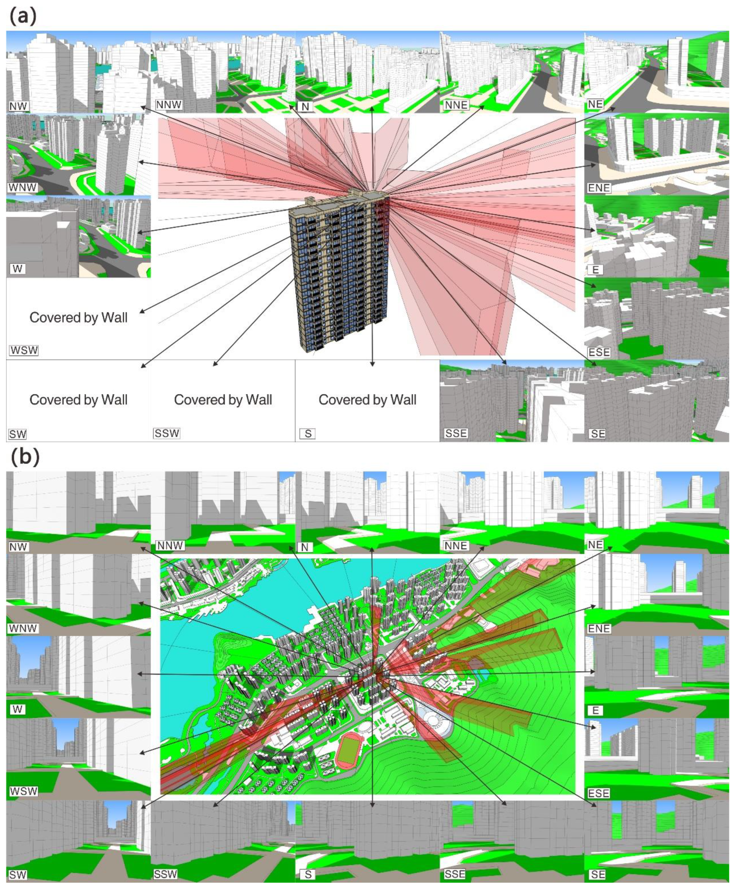
2.3. Analysis of the LVAQ of the Residential District

To establish an accurate LVAQ analysis model suitable for all urban residential districts, multiple residential districts with different scales, locations and construction forms had to be used in the experimental analysis [59]. The model of the selected residential district was decomposed into observation units in ArcGIS. The buildings were divided into building units by apartment, and the ground without any structure was divided into 10 m ×10 m ground units to generate the observation unit system [60].
A building unit was randomly selected for analysis. The geometric center of the building unit was used as the center for a 2000 m radius circle, and a 16-direction rose map was established [61]. In the rose map coordinate system, 16 sectors were generated: N, NNE, NE, ENE, E, ESE, SE, SSE, S, SSW, SW, WSW, W, WNW, NW and NNW, and the included angle for each sector was 22.5°. The viewpoint at the central part of each sector was set, positioning the upper and lower vertical angles to +/−30°. The parts obscured by buildings were removed to generate the viewshed for each sector [62].
For the ground unit viewshed generation, a ground unit was randomly selected for analysis. Except for the vertical viewing angle set to +30°, all other settings were consistent with the building unit viewshed generation [63]. Figure 1 presents the viewshed generation process for the building and ground units in the residential district.
The location and aesthetic score for all urban landscape districts within a 2 km radius around the residential district were delineated and examined [64]. The following formula was used to analyze the LVAQ in each sector of the building and ground units:
L i = G i ( π S i D i 180 ° K i ) ( π S i D i 180 ° ) n = 0 m [ B n A n h n ( D i d n ) S i H i d n ]
where Li is the LVAQ of the i-th sector in a building or ground unit; Gi is the area of green space, including traffic green space, public green space and green space inside the district [65]; Ki is the covering proportion, which is the ratio of the total base area for buildings over the total area of the sector (for high-rise buildings, only the high-rise portion is considered as the base area) [66]; Di is the sector radius (radius of the longest viewshed in the sector); Si is the effective viewshed angle (only the part not covered by nearby buildings is calculated); Hi is the effective vertical viewing angle (+/−30° for building units [67] and +30° for ground units); Bn is the aesthetic score of the n-th landscape area in the Li sector; An and hn are the horizontal angle and vertical angle of the landscape area except the covered part; dn is the distance between the landscape area and the origin of the unit; m is the number of all landscape areas visible in this sector; and n is the serial number of the landscape area.
The overall LVAQ (LT) of the unit is calculated using the formula:
L T = i = 1 j L i 2 S i j 360 ° + 1 j i = 1 j L i
where Li is the LVAQ of the ith sector; Si is the effective horizontal viewing angle; i is the serial number of the sector; and j is the total number of effective sectors in the unit (maximum value is 16). Using a two-step clustering procedure, the results are displayed in different colors to show the LVAQ for all units in the residential district [68]. The total LVAQ (LC) for the whole residential district is computed using the expression:
L C = p = 1 q L p + r = 1 u L r ( q + u )
where Lp is the LVAQ of the p-th building unit in the residential district; Lr is the LVAQ of the r-th ground unit in the residential district; and Q and u are the number of building units and ground units, respectively.

2.4. Analysis of the LVAQ of Residential Districts in the City

Equations (1)–(4) can be used to calculate the LVAQ of each unit and the total LVAQ for the entire residential district. However, given the high number of residential districts and individual units present in a city, these formulas require a large number of calculations that are extremely difficult to process. Therefore, a simpler formula suitable for all kinds of residential districts should be developed. In general, the overall LVAQ of a building is equal to the LVAQ of the building unit on the middle floor, and the overall LVAQ for ground units is equal to the average LVAQ in the center of each area [69]. This principle is also confirmed by the results of this paper. According to these simplifications, a simplified formula to determine the total LVAQ of the residential district (LC) is developed:
L C = b = 1 d L b m + g = 1 k L g m ( d + k )
where Lbm is the LVAQ of the building unit on the middle floor of b-th building; Lgm is the LVAQ of the ground unit in the center of g-th area; d is the number of buildings; and k is the area of the residential district.

2.5. Validation of the Simplified Formula

Since the simplified formula (Equation (5)) reduces calculations by about 90%, errors may likely be introduced into the new estimation method. To validate its accuracy, we randomly selected three residential districts and calculated the LVAQ values using the traditional approach that employs the long formulas. For building units, the average LVAQ for each building was compared with the LVAQ value of the middle floor unit, whereas for ground units, the average LVAQ value of the ground unit was compared with the average value of the central ground unit. We then calculated the Mean Absolute Error (MAE) [70] for the sample districts. The MAE results show that the difference was 6.56%, which is below 10%. This suggests that the simplified formula is a viable alternative to estimating the total LVAQ of residential districts.

3. Results

3.1. Three-Dimensional City Model for LVAQ Analysis
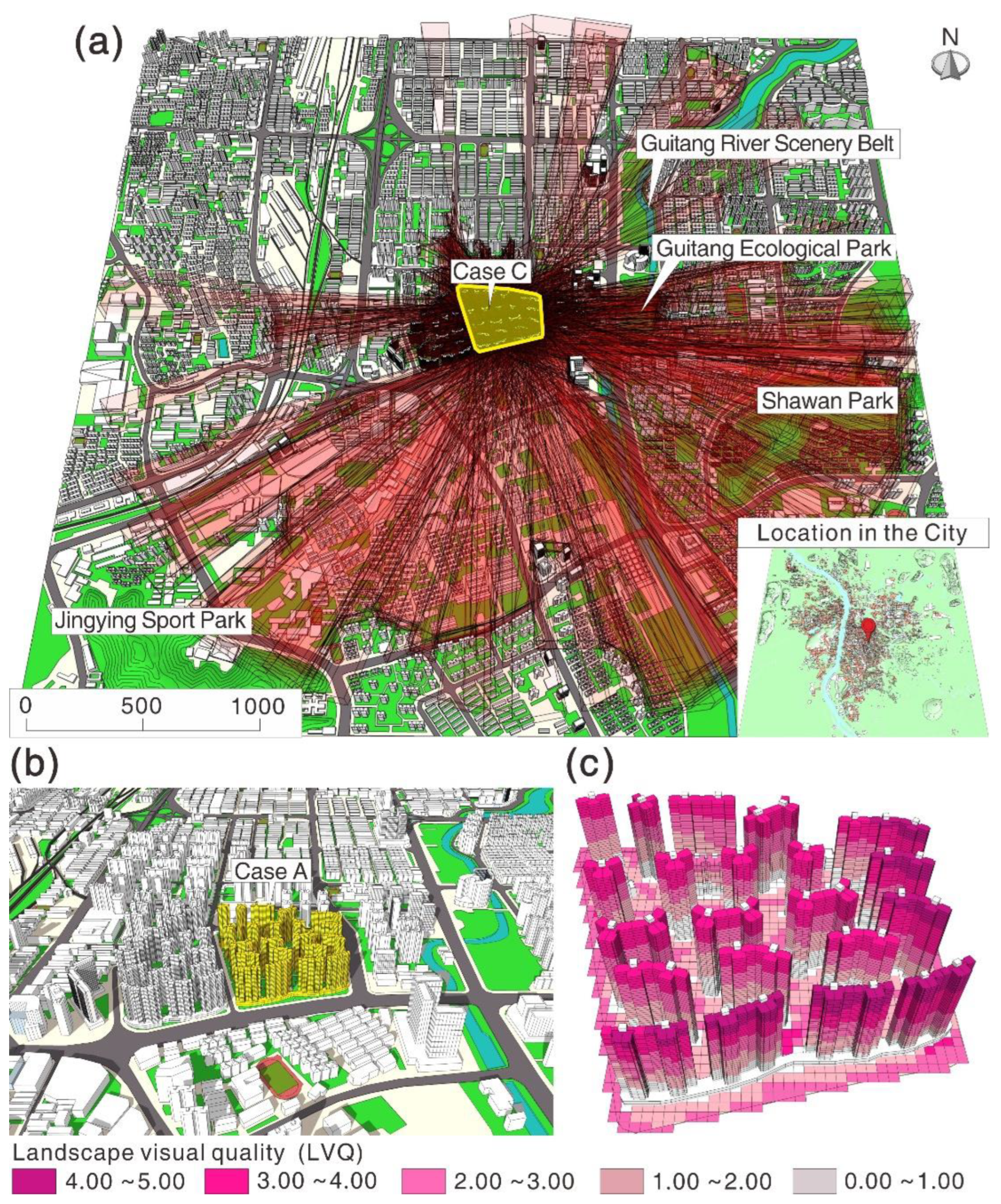
Changsha was used as the research object in evaluating the LVAQ of urban residential districts, and the main urban area of Changsha was taken as the research scope considering the agglomeration of research elements. In 2021, the urban built-up area was about 450 km2, of which about 147.42 km2 were residential districts. The main urban area of Changsha is located in the east-central Hunan Province, China, and can be characterized as having good landscape resources. The Xiangjiang River, an important tributary of the Yangtze River, runs through the main metropolitan region from south to north. Several hills with good forest coverage and large farmlands surround the urban area, and dozens of urban parks are located in the main urban area [71].
A total of 1258 residential districts have been built in Changsha’s urban center, including old residential districts constructed in the 1980s and new residential districts developed in the 2020s [72]. Their architectural forms include tower high-rise buildings, board high-rise buildings, multi-story buildings and villas, and the layout modes are composed of different types, such as determinant, scattered, enclosed, single and mixed. Significant differences can also be found in building density, plot ratios and greening rates [73]. Residential districts that have not been completed or that have not been formed were excluded from our research scope. Considering that Changsha’s main urban area has comparable general characteristics to most cities in China and even in other developing countries, the site is suitable as the research object for analyzing the LVAQ of urban residential districts.
The 3D city model was established as the base of the LVAQ of residential district research. The aesthetic score (ranging from 0.0 to 5.0) of each landscape area was calculated using questionnaire surveys and weighted analysis. Figure 2 presents the residential districts and landscape areas of Changsha’s main urban area.
This 3D city model shows the spatial distribution of residential districts and landscape areas and covers four aspects of information: terrain, architecture, road networks and landscape. Terrain includes the elevation of urban land and the contour lines of mountains and hills, and architecture consists of the external contours, height, the number of floors and other data of all residential and non-residential buildings. For Changsha, there were 23,367 buildings in 1258 residential districts and 31,752 buildings in other districts. Road networks include the trends, outlines and elevation data of urban roads, viaducts and embankments, and landscape consists of the location, scope, aesthetic score and other landscape areas, such as rivers, lakes, mountains, squares and parks.

3.2. Case Analysis

To better understand the factors and relationships affecting the LVAQ of urban residential districts and to develop a suitable approach for the LVAQ analysis, representative cases must be used to clarify the model parameters. According to the experience of case selection in residential districts of previous studies, four principles should be followed in the process of case selection [74]. First, the selected cases should have different locations in the city and should be distributed in the central, mature and outskirts areas [75]. Second, the case should include several main types of architectural forms and architectural layout modes [76]. Third, the building density and plot ratio of cases should be different. Some cases have higher building density and plot ratios, whereas other cases are relatively low [77,78]. Fourth, the quality of landscape and green space around the cases should be different. Some cases are close to the main landscape areas, and the green space rate is high, whereas others do not have good landscape and green space conditions [79]. Through this approach, we can reflect on the complex situation of residential districts using only a few cases.
Based on these principles, three representative cases were selected: Wankelimeixijun (Case A), which is located in the outskirts of the city and near the main landscape area and has moderate building density, a medium plot ratio and a determinant layout, with the architectural form of tower high-rise buildings/board high-rise buildings; Canglonghushang Mansion (Case B), which is located in the mature area of the city and near the main landscape area and has low building density, a low plot ratio and a scattered layout, with the architectural form of tower high-rise buildings/villas; and Xinchengxinshijie (Case C), which is located in the center of the city and far from the main landscape area and has high building density, a high plot ratio and a mixed layout, with the architectural form of board high-rise buildings. These three cases cover most of the characteristic elements of Changsha’s residential districts. We evaluated various aspects and analyzed the different test cases in three phases. For the first stage, we generated and examined the viewshed in 16 sectors around each observation unit (including the building unit and ground unit). In the second stage, the LVAQ of each building and ground unit was determined. In the third stage, the overall LVAQ of the residential district was obtained and analyzed.

3.2.1. Case A: Wankelimeixijun

Wankelimeixijun is near important landscape areas of the city, including Meixi Lake and Taohua Mountain, with aesthetic scores reaching 4.56 and 4.11, respectively. There are also four landscape areas (i.e., Meiling Park, Longwanggang River, Meixihu Art Center and Yuelu Mountain) with aesthetic scores ranging from 3.24 to 4.62 located near the test area. About 80% of the study site is blocked by buildings, mostly having a limited radius (~300–600 m), and only about 20% has a radius of 1000–2000 m. Although the study site in this scenario is only 350 m away from Meixi Lake, only 13% of the area can see the lake through a narrow angle due to building obstructions in the north. In addition, although the Taohua Mountain is visible to 56% of the area, the viewshed radius is limited (~300 m) due to the proximity of the mountains that obscure other landscape areas.
The architectural layout is mainly of the determinant type, and the LVAQ in most building units have high upper floors and low lower floors. The LVAQ of building units on the 18-24th floors reaches 3.0–5.0 but drops to 2.0–3.0 on the 12-18th floors, 1.0–2.0 below the 12th floor and even below 1.0 in some areas. The LVAQ of the building units in the north and middle regions is significantly lower compared to those in the south. For the LVAQ of ground units, significant spatial differences can be observed, which can be roughly divided into four groups. The circular periphery has the highest average value at 3.76, followed by the eastern portion at 2.65 and the western region at 2.57. The central zone of the study site has the lowest average LVAQ estimates at 0.79. The total LVAQ value from the building and ground units was then calculated, and the computed estimate was 3.67. Due to the high concentration of tall buildings in the study site and surrounding areas, the north and middle regions have very limited visibility, and the aesthetically pleasing surrounding landscapes cannot be fully enjoyed. Therefore, its total LVAQ is significantly restricted. Figure 3 shows the analysis process for the LVAQ of urban residential districts for Case A.

3.2.2. Case B: Canglonghushang Mansion

The Canglonghushang Mansion is located between three important landscape areas: the Liuyang River, the Window of the World and Yuehu Park, with aesthetic scores of 4.12, 4.26 and 3.89, respectively. Compared with the previous scenario, the radius and range of viewsheds for Case B are considerably better. About 60% of the study area has a radius of 1000–2000 m, 25% has a 500–1000 m radius and only 15% has less than 500 m. The landscape visibility of the Canglonghushang Mansion is good, with 72%, 44% and 37% of the observation units able to see Yuehu Park, Liuyang River and the Window of the World.
The architectural layout is a mixture of determinant and scattered types. The distribution of building units’ LVAQ is comparable with that of Case A, decreasing from the upper to the lower floors, but the average values are significantly higher than in the previous case. The LVAQ of most building units with more than ten floors reaches 4.0–500. Few buildings in the north have relatively low LVAQ values, but they are still higher compared to most buildings in Case A.
For the ground units, the LVAQ values have significant spatial differences. The average LVAQ in the southwest portion is 4.0–5.0, 2.0–4.0 in the central area and 1.0–3.0 for the northern region. The number and the aesthetic score of the landscape areas in Case B are significantly lower than in Case A. However, because the site is less blocked by buildings and mountains, the visibility of aesthetically pleasing landscapes is much better for Case B, reaching a total LVAQ score of 4.25, which is comparatively higher than 3.67 for Case A. Figure 4 shows the analysis process for the LVAQ of urban residential districts for Case B.

3.2.3. Case C: Xinchengxinshijie

Located in the central area of the city, Xinchengxinshijie is surrounded by the landscape areas of Guitang River Scene Belt, Guitang Ecological Park, Shawan Park and Jingying Sports Park, with aesthetic scores of 3.07, 2.76, 2.84 and 2.28, respectively. These scores are significantly lower than for the landscape areas in Cases A and B. This study site has good visibility in the northeast, east, southeast, south and southwest, where about 62% of the area has a viewshed radius reaching 1000–2000 m. In the other directions, the radius of viewsheds is about 300–500 m due to obstructions by the surrounding buildings. The proportions of observation units that can see the four major landscape areas are 57%, 42%, 34% and 28%, respectively.
The architectural layout is the scattered type, and the average number of floors is 33. The LVAQ distribution of building units can be characterized as high for upper floors and edge buildings and low for lower floors and central buildings. The LVAQ of building units on floors 1–8 is 1.0–2.0, 2.0–3.0 for floors 9–17, 3.0–4.0 for floors 18–26 and 4.0–5.0 for floors 27–33; however, for building units located at the center, the LVAQ values are 0.0–1.0, 1.0–2.0, 2.0–3.0 and 3.0–4.0, respectively. The spatial distribution of LVAQ values for ground units can be characterized as high at the edges and low at the center, with significant variability in areas surrounding the buildings.
The total LVAQ is 2.82, which is significantly lower compared to the previous scenarios. This is primarily because the aesthetic score of the surrounding landscape areas is relatively low. Even if the number of building floors is relatively high and the visibility is good, the surrounding areas cannot generate high LVAQ values. In addition, the study site has many buildings and has a large range. Although the region has a scattered layout, the viewshed at the center is still considerably obstructed, which also reduces the total LVAQ value. Figure 5 shows the analysis process for the LVAQ of urban residential districts for Case C.

3.3. Spatial Distribution of the Total LVAQ in Urban Residential Districts

According to the laws and characteristics of LVAQ distribution in the above three cases, the formula parameters were determined, and a simplified formula was established (see the Method of this paper). Using the simplified formula, the total LVAQ values for all 1258 residential districts in Changsha’s main urban area were calculated. Figure 6 shows the spatial distribution of the total LVAQ represented by blocks with varying heights and colors.
Our statistical calculations revealed some interesting findings on the spatial distribution of the total LVAQ values in the residential districts of Changsha. First, the LVAQ of residential districts has an important relationship with the aesthetic score and distance of the surrounding landscape areas. All residential districts with LVAQ values of 4.0–5.0 and 82.63% of those with LVAQ values of 3.0–4.0 are situated within 500 m around major landscape areas with aesthetic scores above 4.0.
Second, the visual appeal of residential districts significantly declines as the distance from major landscape areas increases. For example, the LVAQ of residential neighborhoods near the Xiangjiang River (one of the most important landscape areas in Changsha) reaches 4.0–5.0, but those slightly farther from the Xiangjiang River (300–500 m) have LVAQ values of 3.0–4.0, with some at 2.0–3.0.
Third, there is a lowland in the central part of the city with an area of about 55 km2, where the visual appeal is considerably low. Of the 272 residential units found in this lowland, 95.22% have LVAQ values lower than 3.0, and 10.29% have LVAQ values lower than 2.0. These values are significantly lower compared to other areas of the city.
Fourth, the LVAQ of residential districts in urban fringe areas is generally low. The LVAQ values of 68.85% of residential districts in fringe areas are 2.0–3.0, and 17.48% are lower than 2.0. These residential districts are generally close to industrial parks and far away from important landscape areas. As residential districts supporting industrial parks, their plot ratios and building density are relatively high, contributing to their lower LVAQ values.

3.4. Comparison of LVAQ and Architectural and Planning Indicators

We used SPSS (version 20) to calculate the Pearson Correlation Coefficients (PCC) between the total LVAQ values and the different architectural planning indicators and to further analyze the influencing factors of the LVAQ in urban residential districts, as shown in Figure 7.
In terms of building density indicators, the PCC value between building density and the LVAQ of residential district is −0.057, and the statistical significance (p-value) is 0.125, which indicates a certain negative correlation that is not significant. When the building density is greater than 35%, the LVAQ values of 58.72% of residential districts are lower than 3.0. When the building density is greater than 40%, the LVAQ values of 64.33% of the residential districts are lower than 3.0. This shows that the building density has a certain restrictive effect on the LVAQ of most residential districts. However, the PCC value between building density within the 1 km periphery and the LVAQ is −0.421, and the p-value is 0.001, indicating a strong negative correlation, which is greater than the correlation of building density with the LVAQ of the residential district itself.
In terms of the main architectural forms of residential districts, the average LVAQ values are the highest among villas (3.56), followed by high-rise buildings (3.39) and multi-story buildings (2.93), and board high-rise buildings have the lowest values (2.68). This was observed even in residential districts with mixed architectural forms. For example, the LVAQ values of residential districts with combined towers and board high-rise buildings (3.44) or board high-rise buildings and villas (3.30) are higher than those with simple board high-rise buildings.
For the architectural layout of residential districts, the LVAQ values are the highest in the scattered type (3.42) and the single type (3.43), followed by the mixed type (3.20) and the determinant type (2.76), and the enclosed type has the lowest values (2.57). No residential district with a determinant or enclosed type has an LVAQ value greater than 4.0. The LVAQ values of 28.06% of residential districts with the scattered type and 22.71% of the single type exceed 4.0, and 68.09% of residential districts with the scattered type and 71.44% of the single type exceed 3.0.
In terms of plot ratio indicators, the PCC value between the plot ratio and the LVAQ of residential districts is −0.095, and the p-value is 0.001, which indicates a clear negative correlation. When the plot ratio is less than 2.0, the LVAQ values of 71.23% of the residential districts are greater than 3.0. When the plot ratio is between 2.0 and 4.0, the LVAQ values of 56.54% of the residential districts are greater than 3.0. When the plot ratio is greater than 4, only 36.28% of the residential districts have LVAQ values greater than 3.0. This shows that the plot ratio has a direct impact on the LVAQ of residential districts; as the plot ratio increases, the LVAQ decreases.
There is a clear positive correlation that was found between the greening rate and the LVAQ of residential districts. The PCC value between them is 0.079, and the p-value is 0.005. When the greening rate is greater than 35%, the LVAQ values in 60.42% of the residential districts are greater than 3.0. When the greening rate is greater than 40%, the LVAQ values of 63.14% of residential districts are greater than 3.0. This shows that the greening rate has an impact on the improvement of the LVAQ in most residential districts. The correlation between the greening rate within the 1 km periphery and the LVAQ is significant and positive, with a PCC value of 0.465 and a p-value is 0.00, which is significantly higher than the correlation between the greening rate and the LVAQ of the residential district itself.
We found that the average distance from the center of the residential district to its peripheries has a certain negative correlation with LVAQ. The PCC value between them is 0.059, and the p-value is 0.037, which shows a negative correlation at the 0.05 level. When the average distance is below 200 m, 61.28% of residential districts have LVAQ values greater than 3.0, and when the average distance is within the 200–400 m range, only 45.13% of residential districts’ LVAQ values are greater than 3.0. The average distance is determined by the size of the residential district, indicating the law that, as the distance (or size) become smaller, the LVAQ becomes higher.
We also found a significant positive correlation between the aesthetic score of major landscape areas within 1 km periphery and the LVAQ of the residential districts, which have a PCC value of 0.746 and a p-value of 0.00. When this indicator is greater than 3.0, the LVAQ values of 91.89% of the residential districts are greater than 3.0, indicating that the indicator is of vital importance for the LVAQ.

4. Discussion

4.1. Spatial Characteristics of the LVAQ in Residential Districts

The results from the case scenarios suggest that residential buildings exhibit high LVAQ values for upper floor units and low LVAQ values for lower floor units. This was observed in all three cases. The LVAQ values for most units above 20 floors are 3.0 or higher, whereas those on the first five floors are often lower than 1.0. However, this does not mean that, as the number of floors increases, the LVAQ becomes higher. In Case B, the LVAQ of the multi-story building close to the landscape area is significantly higher compared to its surrounding high-rise buildings. This suggests that the impact of the location’s elevation on the LVAQ is relative. Tall structures usually have high LVAQ values when their viewshed is not seriously obscured.
By comparing the LVAQ of all building units in the above three cases, it can be found that a building’s average LVAQ value is often comparable to the LVAQ value of its middle floor. For example, the average LVAQ of a 32-story building is comparable to the values of its 16th or 17th floor. A total of 75 of 77 buildings in three cases conform to this rule; only two buildings’ average LVAQ are comparable to 3–4 floors higher than the middle floor, indicating that this rule is effective for almost all buildings.
We also found that buildings at the peripheries of residential districts tend to have higher LVAQ values than those found at the district center. For larger residential districts, more buildings in the central area are likely to have lower LVAQ, mainly due to the farther distance from the landscape areas and the obstruction of the buildings inside the residential district. This suggests that, with all other things being equal, the total LVAQ values of larger residential districts are generally lower compared to smaller residential districts.
In addition, our results show that the spatial distribution of LVAQ for ground units is complex. The difference in LVAQ values of ground units within the same area is often relatively small, but the difference between ground units in different areas can be significant. Similar to building units, the LVAQ of ground units located at the peripheries of residential districts is generally higher than those situated in the central portions. The LVAQ values for ground units near buildings are often low, whereas those far away typically have higher values. Since the visual appeal of ground units is strongly affected by the location and nearby structures, its estimation is comparatively more complex. We also found that, based on the results of the three cases, the LVAQ estimates for ground units at the center of each area are generally comparable to the average LVAQ value of the entire area. This means that the LVAQ value of the ground unit at the center can be used to estimate the total LVAQ of ground areas in residential districts [80].

4.2. Impacts of Indicators on the LVAQ in Residential Districts

By comparing various indicators with the total LVAQ of all residential districts in the city, the factors that mainly influence the LVAQ were summed up. Our results suggest that the aesthetic score of major landscape areas within a 1 km periphery is a crucial factor affecting the LVAQ of residential districts. Among the above nine indicators, this indicator has the highest correlation with the LVAQ. There are landscape areas with high aesthetic scores and less distance, which are prerequisites for the residential district to have a high LVAQ value. For instance, the total LVAQ in Case B is significantly higher than in Case C since the aesthetic scores of the surrounding landscapes are much higher in Case B. However, if the viewshed of the residential district is obstructed, the landscape appeal is significantly reduced. Although the landscape areas with high aesthetic scores are only about 300 m away from the residential district in Case A, their total LVAQ is lower than in Case B due to obstruction by surrounding buildings. Therefore, it is very important for urban residential districts to improve the aesthetic score of the landscape areas and to optimize their layout.
Architectural indicators such as building density, architectural form and architectural layout have complex, restrictive effects on the LVAQ. For example, building density has a certain negative correlation with LVAQ, but the building density within the 1 km periphery of residential districts has a strong negative correlation with LVAQ. In general, as the building floors become higher, the LVAQ becomes better. However, if the structures surrounding the building plots are higher, the LVAQ of the residential district is reduced [81]. The LVAQ of residential districts with enclosed and determinant types is relatively low. For the scattered or single-type residential districts, if the surrounding districts are the enclosed and determinant types, the LVAQ values are affected and cause the decline of their visual appeal [82]. This means that architectural indicators must be compared with the surrounding areas to measure their impact on LVAQ. If we need to optimize the LVAQ of residential districts from architectural indicators, we must consider all newly built and reconstructed residential districts in an urban area.
Planning indicators have a direct impact on LVAQ. Among them, the correlation is the highest between the greening rate within the 1 km periphery and the LVAQ, followed by plot ratio and greening rate, and the average distance from the center of the residential district to its peripheries (or the district size) has a certain negative correlation with LVAQ. The effect of these indicators on residential districts is less complex and less affected by adjacent urban districts. For instance, a high greening rate improves LVAQ, whereas a high plot ratio and large district size reduce LVAQ. As a result of their directness, these planning indicators are the main elements that can be regulated by urban managers. They not only affect the LVAQ of residential districts but also need to be prioritized in urban planning [83].

4.3. Distribution Mechanism of Residential Districts’ LVAQ in the City

From the urban scale, the spatial distribution of LVAQ values in residential districts is closely related to the distribution and aesthetic score of landscape areas. For instance, we found a 20 km corridor on both sides of the Xiangjiang River with high LVAQ values. Other important urban landscapes, including Meixi Lake, Yanghu Lake and Songya Lake, have similar corridors where the LVAQ is also very high. Nearly 200 residential districts with LVAQ values between 3.0 and 5.0 are situated in these prime locations. Moreover, there are hundreds of residential districts with LVAQ values below 3.0 or even 2.0 in the urban fringe areas lacking important landscape areas. Regardless of how low their building density and plot ratios are and how reasonable their architectural forms and layouts are, these residential districts cannot have high LVAQ values due to the low aesthetic scores of the surrounding landscape areas. The location relationship between landscape areas and residential districts also has a significant impact on LVAQ values. By observing the spatial distribution of the total LVAQ of the city, we found that the relative dispersion distribution of landscape areas is more conducive to improving the LVAQ values of residential districts than the relative agglomeration distribution. Regardless of how high the aesthetic score of a landscape area is, it is difficult for its influence range to exceed 2 km due to the limitation of human sight distance. Therefore, a cross-layout of residential districts and highly appealing landscape areas can promote the LVAQ of a given city, and the layout mode where residential districts are heavily compacted in one region with the landscape areas grouped in another can lead to lower LVAQ values [84]. It can be considered that a high aesthetic score and reasonable layout mode of landscape areas are the necessary conditions for the residential districts in a city to have high LVAQ values; both cannot be omitted. Therefore, long-term planning and land management that consider the location and service radius of landscape areas are crucial to ensure the high LVAQ of residential districts [85].
In addition to the impact of the landscape area, the construction of the residential district itself and its surroundings also have an important effect on the LVAQ value. Our results show that some residential districts with LVAQ values lower than 2.0 can also be found near important urban landscape areas, especially the LVAQ of lowland in the central part of the city. By observing their indicators, it can be inferred that, when the buildings in the surrounding districts are very high and dense, regardless of whether the aesthetic score of the surrounding landscape area is high or low, the LVAQ value of the residential district is not high because the buildings cause great obstacles to the scenery [86]. If a group of residential districts adopts determinant or enclosed layouts, the viewsheds of residential districts are blocked from each other, resulting in adverse mutual influence. If the residential districts in an urban area are large, the LVAQ of buildings in their central areas is significantly reduced, causing a decrease in LVAQ for the entire urban area. This means that the reasonable construction of residential districts and surrounding areas is necessary to ensure the full play of the role of landscape areas.
From the above discussion, we can infer that unregulated construction and poorly planned development are the root causes of the low LVAQ of residential districts [87]. By observing the 3D city model, we can see that most of the landscape areas with high aesthetic scores are distributed between the central area and the fringe area of the city. Moreover, the number of landscape areas in the central area is insufficient, and the aesthetic score of the landscape areas in the fringe area is low. Previous studies have shown that this phenomenon exists in many cities in developing countries. As cities become more economically developed, it becomes harder to retain landscape areas, especially in the main urban regions.
In contrast, newly built urban areas often pay more attention to the economic benefits of real estate construction than to the landscape benefits brought by improving the landscape areas [88]. Although unreasonable layouts and excessive size reduce the LVAQ values of the residential district itself and its surrounding districts, 42.14% of residential districts (509 of 1258) in Changsha still adopt the enclosed and the determinant architectural layout, 32.57% of the residential districts have an area of more than 100,000 m2 and 30.21% of the residential districts have an average distance from the center to its peripheries of more than 200 m. The main reasons for these phenomena are that the developers and the managers excessively pursue economic benefits, ignore the landscape value or do not understand the consequences of these construction modes [89]. Therefore, it is necessary to regulate the site selection, scope, layout mode and construction indicators of newly built and reconstructed residential districts from urban planning and construction guidelines.

4.4. Optimization Countermeasures for LVAQ in Urban Residential Districts

Based on our findings, we propose the following optimization strategies:
First, in formulating and revising overall urban plans, the construction indicators and layout mode of newly built and reconstructed residential districts should be strictly controlled. The location and service range of the landscape area should be scientifically planned. Among them, important landscape areas (aesthetic score above 4.0) should have a service range with a radius of 1 km, general landscape areas (aesthetic score above 2.0) should have a service range with a radius of 0.5 km, and each residential district in the city should be covered by the service ranges of two or more landscape areas. For an area that is not fully covered, the landscape area should receive appropriately located new buildings or reconstruction to achieve enough coverage [90]. In urban expansion and development, the allocation of landscape areas, industrial areas and residential districts should be strictly regulated. The landscape area layout should be made in clusters, corridors and blocks to ensure the synchronization of landscape areas and urban construction. For the site selection and construction of landscape areas, the use of existing natural landscapes and city terrain should be encouraged to protect existing environments.
Second, construction guidelines for residential districts should be revised and implemented in the detailed regulatory planning. The plot ratios and building density of newly built residential districts should not be too high, and the greening rate should at least be 35%. The area of a residential district should not exceed 60 hm2 [91]. The layouts of newly built and reconstructed residential districts should mainly be of the scattered type, and the determinant and enclosure types should be avoided. Residential districts close to important landscape areas must designate sufficient viewsheds for the surrounding residential districts. If multiple residential districts in the urban area are planned and constructed simultaneously, their buildings should be arranged according to the location of the surrounding main landscape areas and strive to form landscape corridors that can see the landscape areas. If residential districts with multiple architectural forms need to be arranged in a new urban area, villas should be positioned closest to the landscape area, followed by multi-story buildings, and high-rise buildings should be placed the farthest. For important urban landscape areas, the building height of surrounding residential districts should be regulated to ensure the LVAQ of the region. The contents of the above construction guidelines regarding plot ratio, building density, greening rate, building height limit and building form, among others, should be regarded as mandatory provisions that must be observed by newly built and reconstructed residential districts. The contents of architectural layouts and landscape corridors should be considered as guiding provisions for reference in the design of residential districts.
Third, old residential districts should be gradually transformed in a planned and focused way in urban renewal. According to the location, crowding degree, dilapidated degree and other conditions of old residential districts, the matter of which ones need to be demolished or reconstructed should be determined [92]. Some old residential sections should be demolished and transformed into urban parks to improve the LVAQ of the surrounding residential districts. Other old residential districts should be reconstructed with high-rise building forms, higher greening rates and low-density layouts to reduce their landscape occlusion to themselves and surrounding districts. Large residential districts should be divided into several smaller residential sections and apportion parts for green spaces and landscape areas.

5. Conclusions

By the spatial simulation analysis for LVAQ in representative cases and residential districts in the city, we summarized the forming elements and distribution mechanism of LVAQ.
From the perspective of the overall forming elements, LVAQ is determined by the landscape visibility of the residential district and the aesthetic score of the surrounding landscape area. However, many influence factors exist, and the influence mechanism is relatively complex. Building density, the building density within a 1 km periphery, the plot ratio and the average distance from the center of the residential district to its peripheries have significant limiting effects on the LVAQ of the residential district. When the building density and plot ratio are too high or the distance from the center to the peripheries is too long, it is difficult to avoid having buildings blocking each other. Regardless of how good the surrounding landscape and green space conditions are, residents are unable to appreciate and benefit from them. Therefore, these four indicators are hard indicators that restrict LVAQ.
The role of architectural forms and architectural layouts regarding LVAQ is relatively flexible. For example, the LVAQ of a residential district with board high-rise buildings is generally lower than that of a district with tower high-rise buildings. However, if the building density of the board high-rise building district is very low and the district with tower high-rise buildings is very high, the opposite situation is likely to occur.
In addition, the LVAQ of the determinant residential district is generally lower than that of the scattered one. However, if the row and column building gaps in the determinant residential district face important landscape areas, its LVAQ is likely to be higher than that of a scattered residential district. The action mechanisms of architectural form and architectural layout are relative and closely related to other indicators. The green space rate, the greening rate within a 1 km periphery and the aesthetic score of major landscape areas within a 1 km periphery have an important effect on the residential district’s LVAQ. When the building density, plot ratio and average distance from the center of the residential district to its peripheries are within a reasonable range, the LVAQ of the residential district can be significantly improved. However, if these indicators are too high, they are not able to play a role in improving the LVAQ. Improving the greening rate and creating excellent landscape areas are important to improve the LVAQ.
From the perspective of the distribution mechanism, there is a general rule for the distribution of LVAQ in a single residential district. When the field of view is not seriously blocked, the LVAQ of houses on higher floors is relatively high, the LVAQ of buildings around the residential district is higher compared to those in the center, and the LVAQ of ground units far from the buildings is higher than those close to the buildings. The LVAQ value of the middle floor and the LVAQ of the central ground unit are very close to the mean LVAQ of the whole residential district.
There are also some general rules from the perspective of cities. The LVAQ values of residential districts close to landscape areas of rivers and lakes are often high since the rivers and lakes have high aesthetic scores and do not cause any visual obstruction to the surrounding areas. Regardless of how high the aesthetic score of a landscape area is, it is difficult for its visual impact range to exceed 2 km. Therefore, the distribution of important landscape areas in the city can improve the LVAQ of more residential districts. When multiple residential districts are distributed around important landscape areas, the LVAQ of nearby residential districts is higher. However, if the residential district near the landscape area greatly increases the buildings and plot ratio for economic benefits, the LVAQ of the residential district and its surrounding residential districts decrease significantly. Based on these principles, adjusting the construction mode of a residential district alone cannot significantly improve its LVAQ. Instead, the overall urban plans should be revised to optimize the layout of residential districts, landscape areas and other urban areas, and guidelines should be formulated to guide new district construction. Moreover, old residential districts should be transformed for urban renewal to improve the LVAQ.
The findings in this paper offer a systematic evaluation of LVAQ in urban residential districts and can serve as a useful reference for their construction and renovation. Methodology research is the main theoretical focus of this paper. By establishing a 3D city model with information such as architecture, landscape and traffic, the accuracy and information issues of previous 3D city models are addressed. The questionnaire survey of experts and residents helped quantify the aesthetic degree of urban landscape areas. Through the analysis of three representative residential districts, the general principles of LVAQ distribution in single residential districts were determined, and a simplified model with a smaller data volume and stronger operability was established. Through the analysis of LVAQ distribution and the assessment of various planning and construction indicators, some LVAQ principles for urban residential districts were found, and LVAQ analysis methods applicable for all residential districts were established. This paper is expected to provide methodological support for the LVAQ analysis of urban residential districts in other developing countries, expand research on urban residential and landscape area evaluation, and improve the sustainability of the urban human settlement environment. However, it also has several limitations that must be noted when interpreting the research findings. First, one of the core indicators, the aesthetic score of the landscape, was obtained using questionnaires. A number of spatial quantitative methods for estimating aesthetic scores were developed, such as the garden structural equation, the street view quality evaluation and cognitive landscape mapping [93]. However, these methods require a large amount of data and use complex operations, which are difficult to implement in large cities. To reduce the negative effect on response rates from long surveys, we only selected 80 representative landscape areas in the city as the questionnaire objects. Other landscape areas were relegated to green spaces during calculations. This could have also affected the results. In addition, our study dealt with LVAQ from a static perspective of buildings and the ground and not from the dynamic perspective of the flow of people, flow direction, viewing path and viewing time [94,95]. Recent studies have shown that the accessibility of landscape areas also affects the LVAQ of residential districts. At present, our research mainly focuses on Chinese cities. In the next step, we will study more residential districts in other cities beyond China and make the system more adaptable and universal. Subsequent studies should consider adding new perspectives on LVAQ, including viewing willingness, viewing habits and traffic organization around residential districts.

Supplementary Materials

The following supporting information can be downloaded at: https://www.mdpi.com/article/10.3390/su141811500/s1, Table S1. Main indicators of residential districts in Changsha City. Table S2. Aesthetic scores and questionnaire survey results of landscape areas.

Author Contributions

Conceptualization, Z.Z. and X.Z.; methodology, Z.Z.; software, Z.Z.; validation, Z.Z., Q.H. and X.Z.; formal analysis, Z.Z.; investigation, Z.Z.; resources, Q.H.; writing—original draft preparation, Z.Z.; writing—review and editing, Z.Z.; visualization, Z.Z.; supervision, Q.H.; project administration, Z.Z.; funding acquisition, Z.Z. All authors have read and agreed to the published version of the manuscript.

Funding

This work was financially supported by the Youth Program of the National Social Science Foundation of China: a study on the spatial structure evolution mechanism and model optimization of urban agglomeration in the middle reaches of Yangtze River based on dynamic simulation analysis (No. 19CJL026).

Institutional Review Board Statement

Not applicable.

Informed Consent Statement

Not applicable.

Data Availability Statement

Part of the image data for building the 3D city model comes from Google Earth Engine, available at https://earth.google.com/web/ (accessed on 10 August 2022). The architectural and planning indicators can be obtained from https://cs.fang.com/ (accessed on 4 August 2022).

Conflicts of Interest

The authors declare no conflict of interest.

References

  1. Gobster, P.H.; Ribe, R.G.; Palmer, J.F. Themes and trends in visual assessment research: Introduction to the Landscape and Urban Planning special collection on the visual assessment of landscapes. Landsc. Urban Plan. 2019, 191, 7. [Google Scholar] [CrossRef]
  2. Acar, C.; Acar, H.; Eroglu, E. Evaluation of ornamental plant resources to urban biodiversity and cultural changing: A case study of residential landscapes in Trabzon city (Turkey). Build. Environ. 2007, 42, 218–229. [Google Scholar] [CrossRef]
  3. Page, J. Aesthetic Understanding. Estet. -Eur. J. Aesthet. 2022, 59, 48–68. [Google Scholar] [CrossRef]
  4. Markovic, S. Components of aesthetic experience: Aesthetic fascination, aesthetic appraisal, and aesthetic emotion. I-Percept. 2012, 3, 1–17. [Google Scholar] [CrossRef]
  5. Nohl, W. Sustainable landscape use and aesthetic perception-preliminary reflections on future landscape aesthetics. Landsc. Urban Plan. 2001, 54, 223–237. [Google Scholar] [CrossRef]
  6. Huang, W.Z.; Hu, L.H.; Xing, Y.L. Sustainable Renewal Strategies for Older Communities from the Perspective of Living Experience. Sustainability 2022, 14, 2813. [Google Scholar] [CrossRef]
  7. Velasco, A.E.M.; Garcia, K.A.M.; Sanchez, L.A.M.; Cruz, L.F.G. Urban planning as a strategy for the sustainable development. Andamios 2020, 17, 291–318. [Google Scholar] [CrossRef]
  8. Safarova, K.; Pirko, M.; Jurik, V.; Pavlica, T.; Nemeth, O. Differences between young architects’ and non-architects’ aesthetic evaluation of buildings. Front. Archit. Res. 2019, 8, 229–237. [Google Scholar] [CrossRef]
  9. Pluta, M.; Mitka, B. V-Factor Indicator in the Assessment of the Change in the Attractiveness of View as a Result of the Implementation of a Specific Planning Scenario. ISPRS Int. Geo-Inf. 2019, 8, 78. [Google Scholar] [CrossRef]
  10. Hu, H.H.; Ding, X.H. Analysis on landscape architecture planning and creative design of residential district. Agro. Food Ind. Hi-Tech. 2017, 28, 2879–2881. [Google Scholar]
  11. Zhang, X.M.; Khachatryan, H. Interactive effects of homeowners’ environmental concerns and rebate incentives on preferences for low-input residential landscapes. Urban. For. Urban. Gree. 2021, 65, 127322. [Google Scholar] [CrossRef]
  12. Aleksandrova, K.I.; McWilliam, W.J.; Wesener, A. Status and Future Directions for Residential Street Infrastructure Retrofit Research. Urban Sci. 2019, 3, 49. [Google Scholar] [CrossRef]
  13. Xie, T.; Wang, M.E.; Chen, W.P.; Uwizeyimana, H. Impacts of urbanization and landscape patterns on the earthworm communities in residential areas in Beijing. Sci. Total Environ. 2018, 626, 1261–1269. [Google Scholar] [CrossRef] [PubMed]
  14. Belaire, J.A.; Westphal, L.M.; Minor, E.S. Different social drivers, including perceptions of urban wildlife, explain the ecological resources in residential landscapes. Landsc. Ecol. 2016, 31, 401–413. [Google Scholar] [CrossRef]
  15. Clem, T.B.; Hansen, G.M.; Dukes, M.D.; Momol, E.; Kruse, J.; Harchick, C.; Bossart, J. Sustainable Residential Landscapes in Florida: Controlled Comparison of Traditional versus Florida-Friendly Landscaping. J. Irrig. Drain. Eng. 2021, 147, 04021025. [Google Scholar] [CrossRef]
  16. Andrade, R.; Hondula, D.M.; Larson, K.L.; Lerman, S.B. Landscaping preferences influence neighborhood satisfaction and yard management decisions. Urban. For. Urban. Gree. 2021, 59, 126983. [Google Scholar] [CrossRef]
  17. Hognogi, G.G.; Pop, A.M.; Malaescu, S.; Nistor, M.M. Increasing territorial planning activities through viewshed analysis. Geocarto Int. 2020, 11, 627–637. [Google Scholar] [CrossRef]
  18. Shan, P.Y.; Sun, W. Research on 3D urban landscape design and evaluation based on geographic information system. Environ. Earth Sci. 2021, 80, 15. [Google Scholar] [CrossRef]
  19. Sevenant, M.; Antrop, M. Settlement models, land use and visibility in rural landscapes: Two case studies in Greece. Landsc. Urban Plan. 2007, 80, 362–374. [Google Scholar] [CrossRef]
  20. Brughmans, T.; van Garderen, M.; Gillings, M. Introducing visual neighbourhood configurations for total viewsheds. J. Archaeol. Sci. 2018, 96, 14–25. [Google Scholar] [CrossRef]
  21. Koziatek, O.; Dragicevic, S. iCity 3D: A geosimualtion method and tool for three-dimensional modeling of vertical urban development. Landsc. Urban Plan. 2017, 167, 356–367. [Google Scholar] [CrossRef]
  22. Gu, J.P.; Wang, X.Z.; Liu, G.W. Rediscovering the amenity value of urban landscapes in the mountainous areas with high-rise buildings from the perspective of 3D vertical urban systems. Urban. For. Urban. Gree. 2021, 60, 127018. [Google Scholar] [CrossRef]
  23. Domingo-Santos, J.M.; de Villaran, R.F.; Rapp-Arraras, I.; de Provens, E.C.P. The visual exposure in forest and rural landscapes: An algorithm and a GIS tool. Landsc. Urban Plan. 2011, 101, 52–58. [Google Scholar] [CrossRef]
  24. Biljecki, F.; Stoter, J.; Ledoux, H.; Zlatanova, S.; Coltekin, A. Applications of 3D City Models: State of the Art Review. ISPRS Int. Geo-Inf. 2015, 4, 2842–2889. [Google Scholar] [CrossRef]
  25. Chang, B.X.; Wherley, B.; Aitkenhead-Peterson, J.A.; McInnes, K.J. Effects of urban residential landscape composition on surface runoff generation. Sci. Total. Environ. 2021, 783, 146977. [Google Scholar] [CrossRef]
  26. Zheng, Z.; Zhou, W.Q.; Wang, J.; Hu, X.F.; Qian, Y.G. Sixty-Year Changes in Residential Landscapes in Beijing: A Perspective from Both the Horizontal (2D) and Vertical (3D) Dimensions. Remote. Sens. 2017, 9, 992. [Google Scholar] [CrossRef]
  27. Kaya, H.S.; Mutlu, H. Modelling 3D spatial enclosure of urban open spaces. J. Urban Des. 2017, 22, 96–115. [Google Scholar] [CrossRef]
  28. Liu, L.; Zhang, L.; Ma, J.; Zhang, L.; Zhang, X.; Zhang, X.; Yang, L. An improved line-of-sight method for visibility analysis in 3D complex landscapes. Sci. China-Inf. Sci. 2010, 53, 2185–2194. [Google Scholar] [CrossRef]
  29. Saeidi, S.; Mirkarimi, S.H.; Mohammadzadeh, M.; Salmanmahiny, A.; Arrowsmith, C. Assessing the visual impacts of new urban features: Coupling visibility analysis with 3D city modelling. Geocarto Int. 2019, 34, 1315–1331. [Google Scholar] [CrossRef]
  30. Richards-Rissetto, H. An iterative 3D GIS analysis of the role of visibility in ancient Maya landscapes: A case study from Copan, Honduras. Digit. Scholarsh. Humanit. 2017, 32, 195–212. [Google Scholar] [CrossRef]
  31. Zhao, Y.; Wu, B.; Wu, J.; Shu, S.; Liang, H.; Liu, M.; Badenko, V.; Fedotov, A.; Yao, S.; Yu, B.; et al. Mapping 3D visibility in an urban street environment from mobile LiDAR point clouds. GISci. Remote Sens. 2020, 57, 797–812. [Google Scholar] [CrossRef]
  32. Sullivan, E.A. Seeking a Better View: Using 3D to Investigate Visibility in Historic Landscapes. J. Archaeol. Method. Theory 2017, 24, 1227–1255. [Google Scholar] [CrossRef]
  33. Fan, S.X.; Li, X.P.; Han, J.; Hao, P.Y.; Dong, L. Assessing the effects of landscape characteristics on the thermal environment of open spaces in residential areas of Beijing, China. Landsc. Ecol. Eng. 2018, 14, 79–90. [Google Scholar] [CrossRef]
  34. Harris, V.; Kendal, D.; Hahs, A.K.; Threlfall, C.G. Green space context and vegetation complexity shape people’s preferences for urban public parks and residential gardens. Landsc. Res. 2018, 43, 150–162. [Google Scholar] [CrossRef]
  35. Chamberlain, B.C.; Meitner, M.J. A route-based visibility analysis for landscape management. Landsc. Urban Plan. 2013, 111, 13–24. [Google Scholar] [CrossRef]
  36. Gillings, M. Mapping liminality: Critical frameworks for the GIS-based modelling of visibility. J. Archaeol. Sci. 2017, 84, 121–128. [Google Scholar] [CrossRef]
  37. Foltete, J.C.; Ingensand, J.; Blanc, N. Coupling crowd-sourced imagery and visibility modelling to identify landscape preferences at the panorama level. Landsc. Urban Plan. 2020, 197, 11. [Google Scholar] [CrossRef]
  38. Otahel, J.; Ira, V.; Hlavata, Z.; Pazur, R. Visibility and perception analysis of city monuments: The case of Bratislava city centre (Slovakia). Morav. Geogr. Rep. 2018, 26, 55–68. [Google Scholar] [CrossRef]
  39. Zhai, Y.C.; Li, W. Study on the Construction of Landscape Architecture in Residential District Based on Urban Greening Remote Sensing. J. Sens. 2022, 2022, 1449166. [Google Scholar] [CrossRef]
  40. Chaudhary, A.K.; Warner, L.A.; Ali, A.D. Using perceived benefits to segment residential landscape irrigation users. Urban. For. Urban. Gree. 2019, 38, 318–329. [Google Scholar] [CrossRef]
  41. Hawkins, C.V. Landscape conservation through residential subdivision bylaws: Explanations for local adoption. Landsc. Urban Plan. 2014, 121, 141–148. [Google Scholar] [CrossRef]
  42. Huang, B.; He, X.Y.; Xu, L.; Zhu, Y. Elite school designation and housing prices-quasi-experimental evidence from Beijing, China. J. Hous. Econ. 2020, 50, 101730. [Google Scholar] [CrossRef]
  43. Li, M.; Zhang, G.J.; Chen, Y.L.; Zhou, C.S. Evaluation of Residential Housing Prices on the Internet: Data Pitfalls. Complexity 2019, 2019, 5370961. [Google Scholar] [CrossRef]
  44. Wang, Y.; Yue, X.L.; Zhang, H.O.; Su, Y.X.; Qin, J. Relationship between Urban Floating Population Distribution and Livability Environment: Evidence from Guangzhou’s Urban District, China. Sustainability 2021, 13, 13477. [Google Scholar] [CrossRef]
  45. Jinyu, F.; Bohong, Z.; Qianlong, T.; Boyang, Z.; Ning, L. The Changsha Historic Urban Area: A Study on the Changing Accessibility of the Road Network. Appl. Sci. 2022, 12, 2796. [Google Scholar]
  46. Ying, X.; Fang, Z. Effect of human settlements on urban thermal environment and factor analysis based on multi-source data: A case study of Changsha city. J. Geogr. Sci. 2021, 31, 819–838. [Google Scholar]
  47. Funk, W.; Podmelle, F.; Guiol, C.; Metelmann, H.R. Aesthetic satisfaction scoring—Introducing an aesthetic numeric analogue scale (ANA-scale). J. Cranio-Maxillofac. Surg. 2012, 40, 439–442. [Google Scholar] [CrossRef]
  48. Jin, X.; Wu, L.; Zhao, G.; Zhou, X.H.; Zhang, X.K.; Li, X.D. IDEA: A new dataset for image aesthetic scoring. Multimed. Tools Appl. 2020, 79, 14341–14355. [Google Scholar] [CrossRef]
  49. Tsilimigkas, G.; Derdemezi, E.T. ‘What do you see in the landscape?’: Visibility analysis in the island landscape of Sifnos, Greece. Isl. Stud. J. 2017, 12, 35–52. [Google Scholar] [CrossRef]
  50. Celik, A. The landscape of Kocaeli pedestrian walkway as an example of urban outdoor and user views. J. Food Agric. Environ. 2012, 10, 1262–1268. [Google Scholar]
  51. Hui, E.C.M.; Liang, C. Spatial spillover effect of urban landscape views on property price. Appl. Geogr. 2016, 72, 26–35. [Google Scholar] [CrossRef]
  52. Terkenli, T.S.; Skowronek, E.; Georgoula, V. Landscape and Tourism: European Expert Views on an Intricate Relationship. Land 2021, 10, 327. [Google Scholar] [CrossRef]
  53. Golosova, E.V.; Shelepova, O.V.; Nikolaeva, A.A. On the evolution of the aesthetic advantages of cultural landscapes. Amazon. Investig. 2019, 8, 640–648. [Google Scholar]
  54. Pearson, P. Cultural appropriation and aesthetic normativity. Philos. Stud. 2021, 178, 1285–1299. [Google Scholar] [CrossRef]
  55. Sowinska-Swierkosz, B. Index of Landscape Disharmony (ILDH) as a new tool combining the aesthetic and ecological approach to landscape assessment. Ecol. Indic. 2016, 70, 166–180. [Google Scholar] [CrossRef]
  56. Krejic, N.; Jerinkic, N.K. Nonmonotone line search methods with variable sample size. Numer. Algorithms 2015, 68, 711–739. [Google Scholar] [CrossRef]
  57. Chipperfield, J.O.; Steel, D.G. Design and Estimation for Split Questionnaire Surveys. J. Off. Stat. 2009, 25, 227–244. [Google Scholar]
  58. Park, H.; Na, S. Sample size using response rate on repeated surveys. Korean J. Appl. Stat. 2018, 31, 587–597. [Google Scholar] [CrossRef]
  59. Zhao, Q.; Zhou, K. Research on the community co-production practices: A case study of London and Changsha. Landsc. Archit. Front. 2020, 8, 46–59. [Google Scholar] [CrossRef]
  60. Tatum, K.; Porter, N.; Hale, J. A feeling for what’s best: Landscape aesthetics and notions of appropriate residential architecture in Dartmoor National Park, England. J. Rural Stud. 2017, 56, 167–179. [Google Scholar] [CrossRef]
  61. Kim, Y.J.; Kim, J.G.; Kang, Y.W.; Park, J.J. Evaluation of Pedestrian Space Sequences according to Landscape Elements: Focus on Large-Scale Residential Complexes. KSCE J. Civ. Eng. 2021, 25, 4834–4841. [Google Scholar] [CrossRef]
  62. Yan, J.L.; Zhou, W.Q.; Zheng, Z.; Wang, J.; Tian, Y.Y. Characterizing variations of greenspace landscapes in relation to neighborhood characteristics in urban residential area of Beijing, China. Landsc. Ecol. 2020, 35, 203–222. [Google Scholar] [CrossRef]
  63. Wu, W.; Wang, B.X.; Yang, S. Research on the Simulation Design of Humanistic Landscape Optimization in Urban Residential Area Based on Computer Technology. Inform. -J. Comput. Inform. 2019, 43, 325–330. [Google Scholar] [CrossRef]
  64. Ahmed, F.C.; Sekar, S.P. Using Three-Dimensional Volumetric Analysis in Everyday Urban Planning Processes. Appl. Spat. Anal. Policy 2015, 8, 393–408. [Google Scholar] [CrossRef]
  65. Larson, K.L.; Andrade, R.; Nelson, K.C.; Wheeler, M.M.; Engebreston, J.M.; Hall, S.J.; Avolio, M.L.; Groffman, P.M.; Groveh, M.; Heffernani, J.M.; et al. Municipal regulation of residential landscapes across US cities: Patterns and implications for landscape sustainability. J. Environ. Manag. 2020, 275, 111132. [Google Scholar] [CrossRef]
  66. Robert, S. Assessing the visual landscape potential of coastal territories for spatial planning. A case study in the French Mediterranean. Land Use Policy 2018, 72, 138–151. [Google Scholar] [CrossRef]
  67. Warner, L.A.; Lamm, A.J.; Chaudhary, A.K. Florida residents’ perceived role in protecting water quantity and quality through landscape practices. Landsc. Urban Plan. 2018, 171, 1–6. [Google Scholar] [CrossRef]
  68. Zheng, Y.; Lan, S.; Chen, W.Y.; Chen, X.; Xu, X.; Chen, Y.; Dong, J. Visual sensitivity versus ecological sensitivity: An application of GIS in urban forest park planning. Urban. For. Urban. Gree. 2019, 41, 139–149. [Google Scholar] [CrossRef]
  69. Ding, N.; Zhong, Y.; Li, J.; Xiao, Q. Study on selection of native greening plants based on eye-tracking technology. Sci. Rep. 2022, 12, 1092. [Google Scholar] [CrossRef]
  70. Xie, S.L.; Wang, X.; Zhou, W.; Wu, T.; Qian, Y.; Lu, F.; Gong, C.; Zhao, H.; Ouyang, Z. The effects of residential greenspace on avian Biodiversity in Beijing. Glob. Ecol. Conserv. 2020, 24, e01223. [Google Scholar] [CrossRef]
  71. Kanuk, J.; Gallay, M.; Hofierka, J. Generating time series of virtual 3-D city models using a retrospective approach. Landsc. Urban Plan. 2015, 139, 40–53. [Google Scholar] [CrossRef]
  72. Chen, W.Y.; Jim, C.Y. Amenities and disamenities: A hedonic analysis of the heterogeneous urban landscape in Shenzhen (China). Geogr. J. 2010, 176, 227–240. [Google Scholar] [CrossRef]
  73. Yin, L. Street level urban design qualities for walkability: Combining 2D and 3D GIS measures. Comput. Environ. Urban Syst. 2017, 64, 288–296. [Google Scholar] [CrossRef]
  74. Huang, B.X.; Chiou, S.C.; Li, W.Y. Landscape Pattern and Ecological Network Structure in Urban Green Space Planning: A Case Study of Fuzhou City. Land 2021, 10, 769. [Google Scholar] [CrossRef]
  75. Torrado, J.M.; Calvache, R.D.; Fuster, N. Residential experience and residential location choice. An analysis of centralization and suburbanization residential trajectories. Pap. -Rev. De Sociol. 2021, 106, 413–439. [Google Scholar] [CrossRef]
  76. Dino, I.G. An evolutionary approach for 3D architectural space layout design exploration. Autom. Constr. 2016, 69, 131–150. [Google Scholar] [CrossRef]
  77. Guo, J.; Su, B.; Qin, Z.; Wong, S.W.; Wong, M.S.; Yeung, C.W.; Shen, Q. A study of plot ratio/building height restrictions in high density cities using 3D spatial analysis technology: A case in Hong Kong. Habitat Int. 2017, 65, 13–31. [Google Scholar] [CrossRef]
  78. Usui, H. Building height distribution under zoning regulations: Theoretical derivation based on allometric scaling analysis and application to harmonise building heights. Environ. Plan. B-Urban Anal. City Sci. 2021, 48, 2520–2535. [Google Scholar] [CrossRef]
  79. Jansson, M.; Lindgren, T. A review of the concept ‘management’ in relation to urban landscapes and green spaces: Toward a holistic understanding. Urban. For. Urban. Gree. 2021, 11, 139–145. [Google Scholar] [CrossRef]
  80. Denysyk, H.I.; Lavryk, O.D.; Berchak, V.S. Residential landscapes in the valleys of small rivers in the Middle Bug area. J. Geol. Geogr. Geoecol. 2018, 27, 60–67. [Google Scholar] [CrossRef]
  81. He, M.L. The Implementation and Development of Landscape Design and Ecological Environment Standardization in Coastal Residential Areas. J. Coast. Res. 2020, 55–58. [Google Scholar] [CrossRef]
  82. Liu, M.; Nijhuis, S. Mapping landscape spaces: Methods for understanding spatial-visual characteristics in landscape design. Environ. Impact Assess. Rev. 2020, 82, 21. [Google Scholar] [CrossRef]
  83. Alphan, H.; Asur, F. Geospatial analysis of lake scenery as an indicator for the environment: The City of Van (Turkey) and its surroundings. Environ. Sustain. Indic. 2021, 9, 8. [Google Scholar] [CrossRef]
  84. Llobera, M. Extending GIS-based visual analysis: The concept of visualscapes. Int. J. Geogr. Inf. Sci. 2003, 17, 25–48. [Google Scholar] [CrossRef]
  85. Ruzickova, K.; Ruzicka, J.; Bitta, J. A new GIS-compatible methodology for visibility analysis in digital surface models of earth sites. Geosci. Front. 2021, 12, 13. [Google Scholar] [CrossRef]
  86. Schlapfer, F.; Waltert, F.; Segura, L.; Kienast, F. Valuation of landscape amenities: A hedonic pricing analysis of housing rents in urban, suburban and periurban Switzerland. Landsc. Urban Plan. 2015, 141, 24–40. [Google Scholar] [CrossRef]
  87. Zhang, G.T.; Verbree, E.; Wang, X.J. An Approach to Map Visibility in the Built Environment From Airborne LiDAR Point Clouds. IEEE Access 2021, 9, 44150–44161. [Google Scholar] [CrossRef]
  88. Hayden, L.; Cadenasso, M.L.; Haver, D.; Oki, L.R. Residential landscape aesthetics and water conservation best management practices: Homeowner perceptions and preferences. Landsc. Urban Plan. 2015, 144, 1–9. [Google Scholar] [CrossRef]
  89. Ma, B.Q.; Hauer, R.J.; Xu, C.Y.; Li, W.J. Visualizing evaluation model of human perceptions and characteristic indicators of landscape visual quality in urban green spaces by using nomograms. Urban. For. Urban. Gree. 2021, 65, 13. [Google Scholar] [CrossRef]
  90. Zheng, M.R.; Tang, W.W.; Ogundiran, A.; Yang, J.X. Spatial Simulation Modeling of Settlement Distribution Driven by Random Forest: Consideration of Landscape Visibility. Sustainability 2020, 12, 4748. [Google Scholar] [CrossRef]
  91. Guo, P.F.; Zhang, F.F.; Wang, H.Y.; Qin, F. Suitability Evaluation and Layout Optimization of the Spatial Distribution of Rural Residential Areas. Sustainability 2020, 12, 2409. [Google Scholar] [CrossRef]
  92. You, L.D.; Xu, T.; Mao, X.H.; Jia, H.F. Site-Scale LID-BMPs Planning and Optimization in Residential Areas. J. Sustain. Water Built Environ. 2019, 5, 05018004. [Google Scholar] [CrossRef]
  93. Khachatryan, H.; Rihn, A.; Hansen, G.; Clem, T. Landscape Aesthetics and Maintenance Perceptions: Assessing the Relationship between Homeowners’ Visual Attention and Landscape Care Knowledge. Land Use Policy 2020, 95, 104645. [Google Scholar] [CrossRef]
  94. Zhu, H.Z.; Yang, F.; Bao, Z.Y.; Nan, X.G. A study on the impact of Visible Green Index and vegetation structures on brain wave change in residential landscape. Urban. For. Urban. Gree. 2021, 64, 127299. [Google Scholar] [CrossRef]
  95. Xu, X.; Wang, Q.; Li, C. The Impact of Dependency Burden on Urban Household Health Expenditure and Its Regional Heterogeneity in China: Based on Quantile Regression Method. Front. Public Health 2022, 10, 876088. [Google Scholar] [CrossRef]
Figure 1. Generation process of viewshed for building and ground units: (a) The building unit’s viewshed. In the image, four directions (S, SSW, SW and WSW) are blocked by building walls, indicating no landscape viewshed; (b) Ground unit’s viewshed.
Sustainability 14 11500 g001
Figure 2. Three-dimensional city model of the main urban area of Changsha.
Sustainability 14 11500 g002
Figure 3. LVAQ analysis for Case A: (a) The viewshed for all building and ground units, where the radius, angle and height are displayed; (b) The buildings and landscape situation; the residential buildings are marked in yellow; (c) The LVAQ values for building and ground units.
Sustainability 14 11500 g003
Figure 4. LVAQ analysis of Case B: (a) The viewshed for building and ground units; (b) Buildings and landscape in the site and surrounding areas; (c) The LVAQ of all building and ground units.
Sustainability 14 11500 g004
Figure 5. LVAQ analysis of Case C: (a) The viewshed for building and ground units; (b) The building and landscape situation; (c) The LVAQ value for the building and ground units.
Sustainability 14 11500 g005
Figure 6. Spatial distribution of the total LVAQ in the main urban areas of Changsha.
Sustainability 14 11500 g006
Figure 7. Comparison of LVAQ and architectural and planning indicators in residential districts. (ad) are architectural indicators, and (ei) are planning indicators. In (c), B refers to board high-rise buildings, B/V refers to board high-rise buildings/villas, T/B refers to tower high-rise buildings/board high-rise buildings, M refers to multi-story buildings, T/V refers to tower high-rise buildings/villas and T refers to tower high-rise buildings. In (d), EN refers to the enclosed type, DE refers to the determinant type, MX refers to the mixed type, SC refers to the scattered type, and SI refers to the single type.
Sustainability 14 11500 g007
Table 1. Instrument development for aesthetic score questionnaires.
AspectsQuestionScoring
Criteria:
Question Sources
A. Landscape
visibility
A1 Do you think this landscape area is easy to be seen and appreciated?
A2 Can you easily recall the appearance of this landscape area?
A3 Can you easily see this landscape area when you are relaxing and sightseeing in the city?
very easy: 5,
easy: 4,
average: 3,
hard: 2,
very hard: 1
Funk (2012) [47],
Tsilimigkas (2017) [49]
B. Near-scene
aesthetic score
B1 Do you think this landscape area is beautiful from a close view?
B2 Do you think the interior of this landscape area is beautiful?
B3 Do you think the main scenic spots in this landscape area (such as squares, buildings, waters, etc.) are beautiful?
very beautiful: 5,
beautiful: 4,
average: 3,
unsightly: 2,
very unsightly: 1
Celik (2012) [50], Hui (2016) [51]
C. Far-scene
aesthetic score
C1 Do you think this landscape area is beautiful from a distance of 500 m?
C2 Do you think this landscape area is beautiful from a distance of 1000 m or more?
C3 Do you think the main scenic spots (such as squares, buildings, waters, etc.) in this scenic area are beautiful from a distance?
very beautiful: 5,
beautiful: 4,
average: 3,
unsightly: 2,
very unsightly: 1
Terkenli (2021) [52]
D. Cultural aesthetic scoreD1 What do you think of the cultural connotation of this landscape area?
D2 What do you think of this landscape area regarding its reflection of the local culture?
D3 What do you think of the cultural atmosphere inside this landscape area?
very good: 5,
good: 4,
average: 3,
poor: 2,
very poor: 1
Golosova (2019) [53], Pearson (2021) [54]
E. Landscape
harmony degree
E1 Do you think this landscape area is in harmony with the surrounding landscape?
E2 Do you think this landscape area is harmonious with the surrounding buildings?
E3 Do you think the landscape area is harmonious with the features of the city proper where it is located?
very harmonious: 5,
harmonious: 4,
average: 3,
disharmonious: 2,
very disharmonious: 1
Sowinska-Swierkosz (2016) [55]
Publisher’s Note: MDPI stays neutral with regard to jurisdictional claims in published maps and institutional affiliations.

