Review

Optimising Water Management in Drylands to Increase Crop Productivity and Anticipate Climate Change in Indonesia

1
Research Center for Limnology and Water Resources, National Research and Innovation Agency, Jakarta 10340, Indonesia
2
Research Center for Climate and Atmosphere, National Research and Innovation Agency, Jakarta 10340, Indonesia
3
Research Center for Food Crop, National Research and Innovation Agency, Jakarta 10340, Indonesia
4
Research Center for Horticulture and Estate Crops, National Research and Innovation Agency, Jakarta 10340, Indonesia
5
Indonesian Center for Agricultural Land Resources Research and Development, Bogor 16111, Indonesia
*
Author to whom correspondence should be addressed.
Sustainability 2022, 14(18), 11672; https://doi.org/10.3390/su141811672
Submission received: 31 July 2022 / Revised: 5 September 2022 / Accepted: 8 September 2022 / Published: 16 September 2022

Abstract

:
In the future, Indonesia will become increasingly dependent on dryland agriculture. New adaptive technology innovations able to transform drylands into arable land throughout almost the entire year have been developed to anticipate global climate change in tropical areas. This article reviews the results of research on the importance of climate and water management technology to increase the crop index and productivity in Indonesia. We found that irrigation treatment at 80% of the FAO-recommended rate resulted in the highest maize stover yield (around 13.65–14.10 t h−1). Irrigation treatment at 60% of the FAO-recommended rate for soybeans (at 0.24 L s−1 h−1) produced good-quality soybean seeds. The use of existing water resources can increase the planted area from 1.25 to 1.67 and increase the cropping index during the second planting season in the same area. Agricultural systems based on water management can improve their crop index and productivity, and anticipate climate change to increase farmers’ incomes and wellbeing. Support measures in the form of regulations, legislation, acts, programmes, and policies from central and local governments for land use and management are crucial. The development of infrastructure by establishing water management institutions at the village/farmers’ group levels to allocate irrigation water is a leverage point to develop dryland agricultural systems appropriately and judiciously to assist in sustainable development.

1. Introduction

The Indonesian agricultural sector was able to increase its rice production from 70.85 million tonnes of dry unhulled rice in 2014 to 75.36 million tonnes in 2015. Rice production in this period increased by 6.37% per year [1]. This achievement in terms of increased productivity has enabled Indonesia to regain its status of food self-sufficiency since 2018. Over the same period (2014–2015), maize and soybean production increased by 3.17% and 0.85% per year, respectively.
Indonesia’s agriculture sector experienced positive growth relative to other sectors (2.59% per year) over the two years of the COVID-19 pandemic [2,3]. Indonesia’s economic growth continues to rely on the commodity and natural resource sectors, so climate change is critically impacting production and productivity. There are three fundamental tasks carried out to anticipate climate change on a national scale: (1) improving the quality of the environment; (2) increasing disaster and climate resilience; and (3) mitigating climate change through low-carbon development [4]. A study [5] reported that Indonesia will likely experience most of the impacts in Asia. The negative impacts of climate change can lead to enormous losses to the economic sector, government infrastructure, and people’s livelihoods, as well as floods [6]. Indonesia is still an agricultural country, where most of the means of subsistence are dryland.
The application of the agricultural systems in dryland areas is guided by the conservation of soil and water to prevent damage to the environment. Biophysical factors, conservation techniques, and sociocultural factors are the determinants of the dryland farming systems. Dryland agricultural system innovation, biophysical land improvement factors, water harvest, and new high-yield or drought-resistant plant varieties are crucial to increasing the cropping index and farmers’ incomes [7,8,9]. Drylands are more prevalent in upland, rainfed rice fields, as well as yards with low productivity. The productivity of dryland crops for animal feed—such as upland rice, maize, soybeans, peanuts, cassava, sweet potatoes, peanuts, and grass—is still low. The yield gap is quite large in comparison with the agronomic potential of several superior varieties. Furthermore, the planting index (IP) is low at 130–170%, meaning that the possibility remains of increasing the IP to 200%, 250%, or even 300%, thereby significantly increasing the harvested area. The intercropping system or a mixture of dryland technological innovations can increase the harvested area of various commodities (e.g., upland rice, maize, soybeans, peanuts, cassava, and sweet potatoes) and the land equivalent ratio (LER) value on uplands/fields and yards. The cropping index of dryland areas, generally only planted in the rainy season (December–April), can be increased by implementing supplemental irrigation and water-saving technology with in situ water-harvesting innovations.
The dryland agricultural system, which is based on the biophysical features of the land, altitude, and slopes [10], can be divided into clusters: Cluster A typically consists of flat-to-undulating areas with slopes < 15%, adapted to food crops, and located at an altitude of <200 m above sea level. Cluster B typically consists of undulating-to-hilly areas with slopes of 15–40% suitable for mixed crops and land conservation, located at an altitude of 200–700 m above sea level. Cluster C comprises hilly-to-mountainous areas with slopes > 40% and altitude > 700 m above sea level, which are suitable for permanent annual plants (e.g., forests) [11]. A study [12] by Dwiratna et al. (2018) stated that surface runoff on drylands can be harvested and used as an irrigation source to increase the dryland cropping index to 300%, with a CCA ratio of 6.2 for the sweetcorn–sweetcorn—sweet potato cropping pattern.
The 2020 Indonesian population census recorded an estimated 270.2 million people, with a relatively rapid growth rate of 1.25% per annum [13]. Population growth, accompanied by an increase in purchasing power and educational attainment, and increased awareness of health and fitness, requires greater amount of better-quality food. We must respond to the increasing demand for food in terms of quantity and quality. Future conditions concerning prospects, problems, and strategies to meet the needs of the four major food commodities set by the government (i.e., rice, maize, soybeans, and sugar) according to the research results are as follows: (1) production of rice, maize, soybeans, and sugar continues to increase, but at a slow rate—except for maize, where the main source of production growth is the development of harvested areas, not improved productivity; (2) production capacity to meet domestic demand is increasing for rice, but it is still mediocre, so there is always a risk if there is a loss of production due to uncontrolled external factors such as climate anomalies, etc.; (3) the production capacity of the three other commodities to meet domestic needs is still insufficient, and external sources (imports) are still necessary, especially for soybeans and sugar; (4) Indonesia still has great potential for increasing food production in terms of genetic richness, the availability of untapped land and water, favourable geographic and climate conditions, the availability of labour in rural areas, and technology; and (5) efforts to increase food production still face a number of problems related to the environment, climate, agricultural infrastructure, availability of production facilities, availability of agricultural tools and machinery, land tenure, legality of land tenure, food land conversion, agricultural subsidy budget, farmer institutions, and cross-sectoral integration [14].
Drylands are a future challenge in meeting food needs in Indonesia, having not been used optimally due to water availability constraints. According to one study [15], dryland management reform will yield an estimated ± 11.34 million tonnes of upland rice and 6.91 million tonnes of beans per year. The dryland area in Indonesia is 13.3 million ha, contributing to food production of 11.34 million tonnes, with low productivity of ±1.172 t/ha. The contribution of drylands accounts for 1.79% of national food; thus, dryland reform with innovation in harvesting and water conservation technology has excellent opportunities for development. An example of dryland is Gunungkidul Regency, with a 68,684 ha [16] area for upland rice and productivity of 4.27 t/ha, which can be adopted by other fields, where it can be expanded through the application of technological innovation [17]. The drylands of Gunungkidul have contributed 20–42% of the food reserves in the Special Region of Yogyakarta. Opportunities and challenges for dryland management in Indonesia, referring to the success in Gunungkidul Regency, and doubling the productivity from 1.172 t/ha to 2.244 t/ha, can contribute greatly to rice production—equivalent to 13.3 million times 2.244 t ha area. As a result, this would produce food reserves of 29.84 million tonnes and increase the national contribution to 30%.
This study aims to review the application of technology in drylands to increase the cropping index and plant productivity in anticipation of climate change in dryland areas.

2. Potential, Opportunities, and Challenges of Utilising Drylands for Agriculture in Indonesia

2.1. Potential of Drylands in Indonesia

Drylands are areas of land that are never flooded or inundated for most of the year [18,19]. Opportunities for developing drylands for the production of rice, maize, and soy can be achieved through (a) enhancing the productivity of existing land, (b) increasing IP and/or expanding planting area on existing land, (c) improving cropping patterns to enhance production and economic added value, (d) expanding the area to other drylands (e.g., regions or areas for planting plantations or other annual crops, forestry, and gardens), and (e) expanding new areas or extensification of new land.
Existing dryland areas can be expanded to obtain new (potential) planting areas for rice, maize, and soybeans, on the basis of land resources data at a scale of 1:50,000 [20,21,22], taking into account the distribution of existing agricultural land—namely, rice fields, dry fields, and plantations—as well as land in the form of shrubs, grasslands, and bare land. Existing dry fields and mixed cropland are the focus areas for intensification, while shrubs, grasslands, and bare land are considered new expansion areas (extensification) or potentially available land.
The distribution of existing and potentially available drylands is determined in accordance with the state of the forest. The Ministry of Forestry and Environment divides the land into forested and non-forest areas or other land-use areas [23]. Other land-use areas are defined as agricultural cultivation areas, which currently include rice fields, dry fields, plantations, and temporarily uncultivated land outside the forest area. Forest areas are further classified into protected forest areas, conservation forests, and production forests, of which the latter is further categorised into limited production forests and convertible production forests. Convertible production forest area is a forested area designated for conversion to other land-use areas, with a relinquishment process if replacement land is available. Rice, maize, and soybeans can be cultivated on other land-use areas, convertible production forests, and production forests.
Table 1 shows the area and distribution of existing drylands and new expansion areas for rice, maize, and soybeans in each province of Indonesia. There are around 24.53 million hectares of dryland, consisting of 10.48 million hectares of existing dryland in the form of dry fields and mixed cropland, and 14.05 million hectares of extensified land currently in the form of shrubs, grasslands, and bare land [24]. The largest remaining dryland area is in South Sumatra Province, with 1.47 million hectares, followed by East Java (1.41 million hectares) and Central Java (1.18 million hectares). The largest area for expanding new cultivated area is East Kalimantan Province (about 1.96 million hectares), followed by Papua with 1.88 million hectares. Other large potential cultivated areas are in Central Kalimantan—approximately 1.55 million hectares—and in West Papua, with 1.39 million hectares.
Existing agricultural land and potentially available land suitable for rice, maize, and soy are located on slopes of less than 15%. Approximately 50% of the total land area of existing agricultural land is cultivated with upland rice, maize, and soybeans, with a composition of 20%, 35%, and 5%, respectively. The remaining 50% is used for the cultivation of other commodities. Meanwhile, for potentially available land or new expansion areas, land clearing is conducted if the existing drylands are no longer able to meet the needs.
Based on the overlay with the forest area status map, of the 10.48 million hectares of existing land, as much as 6.54 million hectares is situated in other land-use areas, approximately 1.17 million hectares is in production forest areas, and around 0.40 million hectares is in convertible forest areas. The most extensive dryland within the production forest area is currently found in East Java (274,136 ha), followed by Central Kalimantan (194,823 ha) and Central Java (165,923 ha). The current most extensive food crop areas within convertible production forest are located in North Sumatra at 152,002 ha and South Sumatra at 144,882 ha. Meanwhile, the largest existing dryland in the convertible production forest area is found in Riau Province, with 354,844 ha, followed by Central Kalimantan with 116,425 ha. The largest existing dryland suitable for food production in other land-use areas is found in South Sumatra Province, followed by East Java and Central Java, at 1.14 million ha and 1.01 million ha, respectively.
Table 2 shows the area and distribution of potential drylands available for the development of rice, maize, and soybeans according to forest area status. Based on the table, of the 14.04 million hectares of dryland potentially available for the development of rice, maize, and soybeans, most (5.81 million hectares) is located in production forest, around 2.27 million hectares of dryland is in convertible production forest, and 4.02 million hectares is in other land-use areas. The largest potential available land is in East Kalimantan, with 1.76 million hectares, followed by Papua with 1.89 million hectares, Central Kalimantan with 1.55 million hectares, and West Papua with 1.40 million hectares.
We cannot ignore the potential of drylands to sustain food development. Generally, soils in dryland areas have a better natural fertility rate than acid drylands, characterised by a soil pH > 5.5, a base saturation > 50%, and a medium–high cation-exchange capacity (Table 2). In drylands, the soil order generally consists of Inceptisol, Vertisol, Mollisol, and Alfisol [25,26].

2.2. Opportunities and Challenges of Dryland Utilisation for Agriculture

Drylands are one of the agroecosystems with high potential for agricultural cultivation, including food crops, horticulture (i.e., vegetables and fruits), annual crops, and livestock. The main limiting factors in agricultural development are water scarcity, low organic matter content, and high erosion on steep slopes. Appropriate land use has created an impediment to cultivation. Much of the area has been used for agriculture and other uses, including settlements, industrial areas, infrastructure, etc.
The greatest opportunity to increase land productivity by expanding seasonal crops in drylands is in Kalimantan, which accounts for about 3.6 million ha—the majority being in East Kalimantan (1.89 million ha) and West Kalimantan (0.856 million ha). All drylands of Kalimantan have a humid climate. Meanwhile, opportunities for the development of drylands can be found in Nusa Tenggara, covering an area of 137,659 ha, and in Sulawesi/Southeast Sulawesi, with 93,417 ha. Another opportunity to expand the area of dryland seasonal crops is in Papua, with around 1.69 million ha, along with the island of Sumatra—especially in North Sumatra (0.429 million ha). In other provinces, the potential area for expansion is less than 300,000 ha [27]. The data presented are based on indicative land available for the development of food crops in biophysical terms only. The above data show that the potential for land development is quite extensive, especially in humid climates. However, data assessments indicate that, in fact, a large portion of the land is in the category of land not available for the development of food crops. Various factors should be considered as criteria and procedures for determining the availability of the aforementioned lands.
Table 2 shows that the land-use opportunities available for the expansion of rice, maize, and soybean cultivation areas in the other land-use areas are still quite extensive, pedologically and biophysically speaking. However, the fact is that most of these lands are the property of individuals or the private sector, and are generally unused or neglected. Consequently, the 4.02 million hectares of land located in other land-use areas is difficult to exploit as a newly expanded agricultural area without national policy support. Meanwhile, the use of potentially available land in convertible production forest areas for agriculture requires a relinquishment process by the Ministry of Environment and Forestry. Furthermore, potential land available in production forest areas requires replacement land (land exchange) if it is to be used for purposes other than forestry—generally in other land-use areas.
The potential use of available land in the other land-use areas category, according to national policy, is intended to include (1) regulations and policies at the level of laws or government regulations that regulate landowners who abandon their land, both privately and individually so that it can be used for the expansion of agricultural areas; (2) regulations that are capable of revoking land-use rights for private owners who abandon their land; and (3) regulations and legal certainty for those who are interested in using the land for the expansion of food/agricultural areas. Without going through these three forms of regulation, leveraging the potential lands available in other land-use areas is not easy, due to the legal protections afforded to landowners who abandon their lands.
In addition, only a portion of the potential land available in the other land-use areas is dispersed in larger areas; in contrast, others are fragmented in relatively narrow areas or scattered. On the basis of the aforementioned issues, the most realistic and timely administrative opportunity is to use state land in the form of convertible production forest areas covering an area of 2.67 million hectares. The release mechanism is included in the Ministry of Environment and Forestry Regulation R.51/Menlhk/Setjen/KUM.1/6/2016, which changes the designation of the forest function to that of non-forest or other land-use areas.
Water availability is the main limiting factor in dryland agroecosystems for agricultural development—especially for food crops. With an annual precipitation of less than 2000 mm/year, and only 3–4 wet months [19,28], rainwater is available for just one growing season. Low annual rainfall within a relatively short timeframe produces high intensity of rain, making its destructive power greater, and putting drylands at high risk of soil degradation from erosion [29,30]. The low organic matter content reflects the high rate of land degradation (<1%) that has occurred in a number of dry climate regions [31]. The dominant shallow soil solum in dryland [19,26,28,31] leads to very low tolerable soil loss. It is therefore vital to prevent erosion to maintain the sustainability of agriculture. Another limiting factor is the high prevalence of rocks on the ground surface [28].
Agricultural practices in drylands—particularly in the Nusa Tenggara Islands—are mainly carried out to produce seasonal food crops such as maize and green beans. Crop production in drylands—especially of maize—is also generally relatively higher than in acid drylands, because of adequate soil fertility. Nevertheless, the average production achieved remains below its potential. Water management is the primary key to improving land productivity, while paying attention to sustainability issues, including the management of nutrients and organic matter and the prevention of erosion.

3. Climate Change and Its Impact on Food Farming in Indonesia

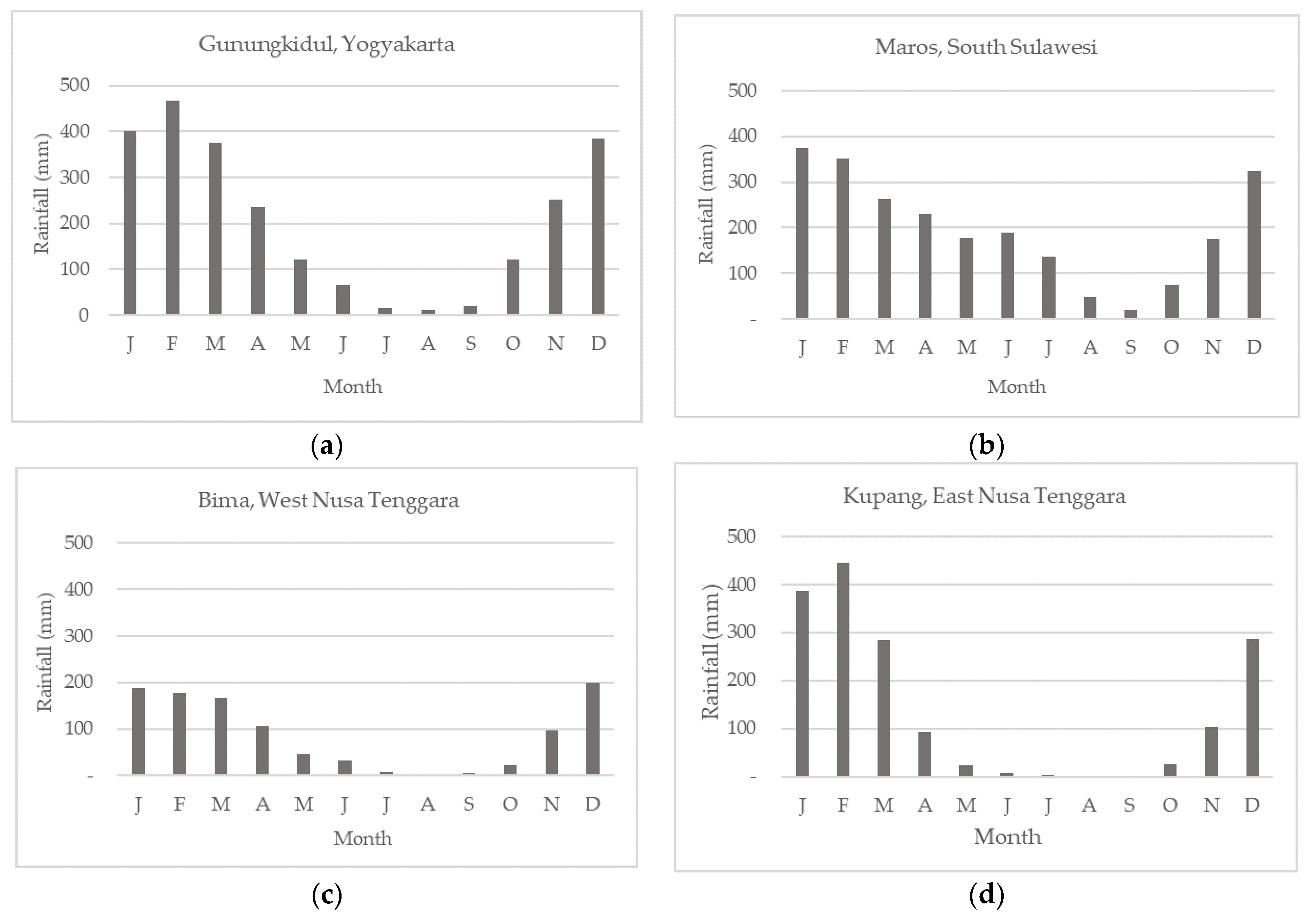
3.1. Climate Characteristics in Dryland Locations

Indonesia has three climate regions, with differing characteristics: Region A is located in southern Indonesia, from South Sumatra to the island of Timor, the south of Kalimantan, Sulawesi, and parts of Papua. Region B is located in northwest Indonesia, from North Sumatra to northwestern Kalimantan. Region C includes Maluku and North Sulawesi [32]. The extensive Indonesian territory, bordered by two oceans and two continents, has resulted in the country’s complex and dynamic climate [33]. The three rainfall characteristics still exhibit many variations. Rainfall patterns and distribution are crucial for agricultural activities [34], especially in areas that depend solely on rainfall. Indonesia, which mostly consists of rice fields, is very vulnerable to the changes and variability of rain. Rice requires a high volume of water to achieve optimal growth, so it is strongly influenced by climate variability [5].
Dryland is an ecosystem that is never inundated or waterlogged for most or all of the year. The dryland agricultural system (DLAS) is very dynamic and not easy to predict [35]. Rainfall data from several sampling locations, representing Java, Sulawesi, and Nusa Tenggara, were collected for the period 1992–2014 (Figure 1) to provide an overview of rainfall patterns in DLAS areas. In general, rainfall in most DLASs is low in July, August, and September (averaging less than 200 mm/month), with an uneven distribution. Low precipitation translates into a very short growing season if farmers depend only on the rainy season. These data are also supported by the Agro-climatic Resource Map (Figure 2) [36,37].
The Oldeman climate classification is one of the most widely used climatic classifications in agriculture according to the criteria of wet and dry months [38]. Based on the Oldeman classification, the climates of most DLAS regions are classified as types C3 and D3, with an average dry period of 4–6 consecutive months. Such regions should generally be planted with caution, especially when planting during the dry season. There is a need to adjust the crops and varieties planted with the support of other water sources. Stewart and Peterson (2015) [39] suggest the use of green water—that is, part of the precipitation stored in the soil or temporarily on the soil or vegetation during the growing season that plants can use for transpiration. The volume of water that is transpired is directly related to biomass production. It is therefore possible to increase the capture and storage of rainfall in dryland areas, and to use it more effectively for cultivation.

3.2. Effects of Climate Change on Farming Systems in Dryland Agricultural System (DLAS) Locations

As an archipelagic country located on the Equator, Indonesia is vulnerable to climate change [40]. In the future, the agricultural sector will face several biophysical challenges and barriers, including those due to global warming as a result of the increasing concentrations of greenhouse gas emissions in the atmosphere. These have resulted in physical and biological changes in the environment, including increased tropical storm intensity; changes in rain, wind, and animal and plant reproduction patterns; distribution of species and population numbers; and increased frequency of pests and disease [41].
Indonesia’s climate variability has been characterised by rising temperatures over the past several decades, which are expected to increase further [42]. The projected increase in sea level up to 2100 serves as a sign of climate change [43], increasing the risk of flooding in lowland areas along the coastlines [44]. In addition, there are changes in the rainy season and dry season, whereby precipitation in the wet season in southern Indonesia is increasing, while precipitation during the dry season in the north is increasing [45,46].
The increase in temperature can prolong the planting time and accelerate the ripening of fruits and seeds, thereby decreasing the quality of yields [47]. Rising global temperatures have resulted in melting glaciers, which contribute to rising sea levels, resulting in reduced agricultural land along the coast; contributes to the thermal expansion effect of the oceans; and alters the frequency and severity of extreme weather and climate events [48,49].
DLAS regions tend to experience drought levels that have a more adverse impact on plant growth and production. Extreme climates in Indonesia are usually associated with ENSO (El Nino–Southern Oscillation) [50]. In addition, global warming tends to increase the frequency of El Nino [51]). The increasing frequency of El Nino will delay rains, which will impact agriculture in Indonesia, where agricultural production is heavily dependent on rainfall. Rains delayed by up to 30 days during the dry season in Indonesia (July–September) will reduce agricultural yields by as much as 75% by 2050 [46]. Droughts in Indonesia, especially those affecting agricultural land, have become more intense [52]. Climate change also increases production costs by 50% and reduces farmers’ incomes by 25% [53].

3.3. Efforts to Anticipate the Impacts of Climate Change (Adaptation and Mitigation)

The agricultural sector remains one of the most important foundations of Indonesian economic development. The agricultural sector contributes as a food provider and to the value of gross domestic product (GDP), and contributes significantly to the absorption of the workforce. The development of the food crops subsector—especially rice—is very important in providing food to the community. At the same time, other subsectors also offer significant opportunities to support sources of income for a variety of agricultural commodities, and to improve economic and environmental conditions.
However, the agricultural sector is threatened by the degradation of land resources, the pollution of agricultural land, the conversion of land, and the very small agricultural land ownership (average < 0.5 ha). Over the past few years, the agriculture sector has also faced increasingly significant challenges, such as the growing trend of extreme climate events. Floods, droughts, and attacks by pests and diseases are impacts that often occur due to extreme climate events. The development of food crops in drylands has increasingly felt the significant impacts of climate change, such as the extreme climate event El Nino, which affects the availability of water. The impact of climate change has led to reduced planting area and production of food crops—especially rice—which has ultimately disrupted food security [54]. Hatfiels (2017) [55] revealed that climate change is occurring and affecting biological systems through higher temperatures, more variable precipitation, and an increase in atmospheric CO2, which has strongly influenced agriculture. Special efforts are necessary to minimise the impacts and risks of climate change.
The link between climate change and development has sparked growing interest among development organisations in integrating adaptation into rural development plans, with the goal of building local resilience effectively [56].
The two main steps in anticipating climate change are adaptation and mitigation, where mitigation is a concomitant benefit of adaptation. Adaptation refers to a range of actions taken in response to events caused by climate change/global warming. There are adaptation needs when the expected risks or impacts of climate change require actions to ensure the safety of people and goods, including ecosystems and their services. Adaptation needs represent the gap between what may occur as a result of climate change and what we want to happen [57]. The vulnerable agricultural sector needs to adapt, because it can suffer as a result of climate change, which disrupts food security.
One of the efforts to anticipate the increasing impacts of climate change is to integrate climate change vulnerability studies with national short-, medium-, and long-term development plans and priorities [58]. Thus, development programmes and projects can be a means of reducing vulnerability while at the same time increasing the community’s capacity to adapt. Among the many actors and roles associated with successful adaptation, there is considerable evidence for two important roles in the advancement of adaptation: that of local government, and that of the private sector [57]. In their implementation, adaptation and mitigation should be prioritised in the DLASs’ key areas. Key areas have been identified as locations where precipitation is strongly influenced by global events such as El Nino and La Nina [33,59].
Adaptation and mitigation efforts in DLASs mainly concern water supply, as water is the biggest challenge in commodity development in DLASs. The concept of rainwater harvesting and water efficiency is very important to implement within DLASs. Excess rainwater is collected during the rainy season and used effectively during the dry season, when the availability of water is very limited. Rain harvesting can take place through the provision of water-harvesting buildings such as small agricultural reservoirs, dams, channel reservoirs, long storage, etc. Meanwhile, water efficiency can be enforced by appropriate water management and regulations to provide according to the needs of the commodity and the plants at each phase. Different water-saving irrigation models can also be applied to DLASs [60]. In addition, managing soil organic matter is critical to increasing the water-holding capacity of the soil to help prolong soil moisture. The associated benefits of crop adaptation (mitigation) and water savings can be achieved by adjusting the water supply to the needs of plants and selecting low-emission commodities. Climate-smart agricultural practices, which have added benefits in increasing agricultural productivity, are vital for capacity building—especially for smallholders.

4. Farming Systems and Productivity Dynamics

4.1. Farming Systems’ Existing Conditions

The current state of DLASs that produce food is very important; many commodities can be developed, and the forms are varied. Food crops, plantations, and horticulture dominate DLASs’ existing agricultural system. The cropping pattern system is mostly mixed commodities, such as food crops in the main planting field, terrace lips for terrace reinforcement and animal feed, and annual plants as permanent vegetation. The current agricultural system has a positive correlation with the daily needs of farmers to meet the basic food needs of families and the country.
In addition to rice, other food crops planted include maize, sorghum, soybeans, green beans, cassava, sweet potatoes, etc.; plantation crops, including coconut, cocoa, rubber, etc.; and horticultural crops, including fruits (e.g., mango, custard apple, durian, watermelon, melon, etc.) and vegetables (e.g., chilli, red onion, long beans, mustard greens, cabbage, etc.). According to analysis [61,62], there is about 29.39 million ha of potential dryland for food crops in Indonesia. Approximately 1.13 million ha has potential for highland vegetable crops, and approximately 66.72 million ha has potential for annual crops, including fruit crops. Approximately 2.42 million ha has potential for livestock grazing. The results of one study [63] state that dryland sustainability and resilience are innovations in the response to climate change associated with social challenges.

4.2. Agricultural Socioeconomic Characteristics in Dryland Agriculture Systems (DLASs)

The management of drylands is often constrained by the socioeconomic characteristics of farmers, related to the demographic characteristics of farmers and the complexity of dryland issues faced by farmers. Several major barriers include the educational level, limited total land ownership (especially in dryland areas with wet climates), transfer of land tenure status from ownership to land ownership or lease (absentee land status), and fragmentation of land, resulting in limited land ownership by farmers. Development and support for agricultural technology and institutional supports are also very limited. Similarly, farmers do not have sufficient access to production inputs, technological innovation, and capital. As a result, the adoption of agricultural technologies for drylands is still lacking, with one characteristic being the high gap in productivity between the farmers’ level and research results. In addition, technological innovations that have been proven to be technically and economically feasible in research and development are no guarantee of adoption by dryland farmers, due to the weak technological transfer system. The role of extension institutions in transferring technological innovation and empowering communities continues to be weak [10,64].
Other socioeconomic aspects that frequently become barriers include the availability of infrastructure, such as the considerable distance from the markets to the farms, the quality of the villages’ road networks, and the ineffectiveness of rural transport capital. Outside of the island of Java, long-owned and -occupied drylands are relatively vast. However, human resources are limited, rendering the management of drylands for food crops very widespread. Furthermore, many farmers still practice the slash-and-burn technique, with shifting cultivation patterns outside of the island of Java.
At the national level, the ownership, designation, and control status of drylands controlled by individuals or legal entities is highly problematic or at risk of conflict. This problem is caused by the location of certain lands within forested areas, such as protected forests, limited production forests, production forests, or convertible production forests. Government policy is required to change the status of land to other land-use areas. Secondly, to address the needs of agricultural land in the future, there must be a government policy to convert the status of convertible production forest lands to other land-use areas. This policy is necessary to implement agrarian reform—for example, the relocation of smallholder farmers or smallholders (e.g., Java, Bali) to areas where convertible production forest land is available (e.g., islands), the status of which can potentially be changed to other land-use areas [10].

4.3. The Implementation of Technological Innovation in Drylands

The application of technological innovation is an absolute requirement in the use of drylands to overcome limiting factors and increase the efficiency of the use of water resources. Technological innovations in water management that are the main support for optimising drylands include rain-harvesting technology and additional water-saving irrigation technology.

4.3.1. Rain-Harvesting Technology

Many technologies have been produced for the development of drylands, but most approaches are under cultivation, emphasising aspects related to soil and plant cultivation. Water resource management is more focused on conserving soil moisture (rather than water conservation) and increasing groundwater reserves (i.e., water storage) [65]. Since the 1980s, the technique of harvesting rain by means of small agriculture reservoirs, has been used to irrigate drylands or used during the dry season [66,67,68]. The type of rain-harvesting technology and runoff technique that can be used depends on the amount and distribution of rainfall, the water reserves required, the type and size of the catchment area, and features of the soil or rock. In addition, the storage capacity to be built is also largely determined by the local rainfall, the coefficient of surface runoff, the level of water demand, the availability of funds, and the technical capabilities [69,70].
Small agriculture reservoirs, dams or reservoirs for water collection, parallel wells, channel reservoirs, shallow wells, deep wells, and long storage are types of facilities that have been widely constructed for rainwater harvesting in Indonesia. Figure 3 shows a number of models of water-harvesting infrastructure. Water conservation through the construction of similar dams and reservoirs is generally implemented to increase the availability of water, affecting agricultural production, land productivity, and farmers’ income. Irianto (2002) [71] suggests that harvesting rain and runoff can enhance the sustainability of agricultural systems in dry environments, reducing the rate of erosion, sedimentation, and even the risk of flooding if the amount of harvested runoff is significant. Furthermore, large quantities of rain and runoff can anticipate El Nino climate anomalies or extend the planting period to the end of the rainy season [72,73,74].
Since 2001, the Indonesian Agency for Agricultural Research and Development (IAARD) has developed rainwater-harvesting technology through channel reservoirs. The channel reservoir is a technique for harvesting rainwater and runoff by blocking the flow of water into a stream, channel, or ditch and keeping it in storage as supplemental irrigation water during the dry season. In addition, channel reservoirs also reduce water flow velocity, reduce peak discharge, and extend response time in a watershed, and reduce sedimentation in downstream areas.
Channel reservoirs as irrigation sources have been developed in several dryland areas, such as West Java, Central Java, Yogyakarta Special Region, East Java, Southeast Sulawesi, and South Sulawesi [65,75,76,77,78,79,80,81,82,83,84,85,86]. Results show that dryland productivity can potentially be increased if (1) the problem of water availability fluctuations can be minimised, (2) the water storage capacity of the watershed can be maximised naturally and artificially, and (3) the efficiency of water use and the commodity cultivated can be improved and optimised [78].
Cascaded channel reservoirs entail the construction of several channel reservoirs in one river channel. Examples of cascaded channel reservoirs can be found in West Java, DI Yogyakarta, and South Sulawesi. With the construction of a multilevel channel reservoir, the rainfall and runoff harvested can increase the planted area and rice production, thereby transforming the upland rice cultivation system into a system of lowland rice and secondary crops planted in the first and second dry seasons.
The application of rain-harvesting technology may also affect the area and cropping index. Research on the multilevel channel reservoir in the Bunder micro-watershed of Gunungkidul, DI Yogyakarta resulted changes in agricultural land cropping patterns after supplemental irrigation from the channel reservoir, from paddy/maize/cassava–peanuts–fallow, to paddy–other annual food crops/vegetables.
In Central Java, supplemental irrigation facilities from channel reservoirs can increase the production of shelled maize by 65% compared to the prior applications of rain-harvesting technology and surface runoff. Moreover, there is a change in the crop types, from food crops to shallots, chilies, melons, and ginger [75].
The study results in the village of Jogjogan (Cisarua District, Bogor Regency, West Java) showed that a channel reservoir with 100 m3 capacity has the potential to increase the planted area by 4 ha. Channel reservoir irrigation can meet the water requirements of existing plants during the dry season, allowing the cultivated land in the study site to be planted all year long, with an increase in cultivated area of 4.11 ha during the dry season [87].
The observations of three cascaded channel reservoirs in the village of Semin, DI Yogyakarta, showed a change in the target irrigation area and a change in cropping patterns in Semin—from paddy–paddy and secondary crops–fallow to paddy–paddy–other annual crops and paddy–other annual crops–other annual crops [84]. There is a need to analyse the adequacy of water in the channel reservoir in meeting the need for supplemental irrigation water in the dry season to determine the effectiveness of the channel reservoir in agricultural irrigation. However, in channel reservoir 3, water is still abundant, and has the potential to increase the target irrigation area. Water supplies from channel reservoirs 1 and 2 are only able to meet water needs at the start of planting. In the mid-planting and before harvest, the plants experience drought due to a shortage in the water supply. Several methods are required for more efficient use of channel reservoirs, including reducing the target irrigation area, implementing crop rotation, planting shortlived crops (e.g., vegetables), and planting water-efficient plants [88].

4.3.2. Supplemental Water-Saving Irrigation Technology

Irrigation is the application of water to soil and plants to meet their water requirements throughout their growth cycle. The principle of water provision for dryland agriculture—especially for food crops—is to supply water that is efficient and can deliver optimal results. Water supply depends on the water needs of the plants at each growth stage, with the appropriate volume, frequency, and application time to increase the efficiency of water use while ensuring maximum crop yields.
In drylands, supplemental irrigation is the additional irrigation given to the plants to provide the required water. The water supplied may originate from rainwater or other sources, such as reservoirs, small agriculture reservoirs, channel reservoirs, etc. According to one study [89], supplemental irrigation technology may prolong the growing season (for seasonal crops) in most areas of Indonesia. It can range from restricted supply to the rainy season to the middle of the dry season. If rain harvesting, water-saving technology, and supplemental irrigation are applied considering the technical and socioeconomic conditions, then the problem of water shortages caused by climate change can be resolved.
Broadly speaking, there are four methods of providing water (Schwab et al. 1981 in Kurnia 2004 [90]), namely, (1) providing water on the surface (surface irrigation), (2) providing water below the soil surface (subsurface irrigation), (3) sprinkle irrigation, and (4) drip or trickle irrigation. Subsurface water supply is very suitable for dryland irrigation because it uses buried pipes or closed pipes to reduce water loss due to evapotranspiration. This watering technique is efficient because it is applied directly to the plant. According to Kurnia (2004) [90], in coarse-textured soils, the efficiency of water use through subsurface watering is twice that of surface water application. Drip irrigation may also be an option because the water is given at a low speed and is applied directly around the plants via emitters to make effective use of water. According to BBSDLP (2010) in [88], drip irrigation makes effective use of very limited water availability, and is suitable for application on drylands with a relatively sloping topography.
Limited water availability is a feature of drylands. Thus, a cropping system capable of increasing water supplies and water-use efficiency (WUE) and suppressing erosion is vital to maximising plant productivity [91]. WUE describes the crop yield (production) per unit of water used [89,92]. WUE also describes crop yield per unit of rainfall or total biomass per unit of irrigation water. WUE can be found on a daily, weekly, seasonal, or yearly scale [92]. Moreover, other studies indicate that there are several technologies to improve WUE, including land configuration (e.g., paddy field ridges and ditches, beds, border strips, terraces, alternating bed systems, and water-harvesting techniques), agronomic practices (e.g., soil processing methods), alley cropping, weed control, intercropping systems, strip cropping/vegetative barriers, and the use of mulch [89].
On drylands, water resource problems are caused by limited, dispersed, and unconnected water resources, and conventional irrigation water management. The limited water resources in eastern Indonesia—especially East Nusa Tenggara and West Nusa Tenggara—are due to the low precipitation (<1000 mm/year) and limited surface water resources. The concept of managing water resources should not necessarily be based on building large-scale reservoirs in areas where water resources are scarce, but rather the construction of a large number of small-scale rain-harvesting structures in multiple locations, depending on the potential and availability of surface water resources and the targeted irrigation area. The creation of a water-saving irrigation system in combination with land management to maintain soil moisture is the only way to overcome the limited water resources in the development of dryland agriculture. Water-use efficiency is an effort to provide irrigation water in line with the availability of existing water resources to be used efficiently to increase the target area of irrigation services.
Water-use efficiency is the ratio between the number of seeds produced by plants (e.g., grains, etc.), in kilograms per ha, and the total amount of water consumed to produce these products, in m3 per ha. Research on the efficiency of water use for maize, peanuts, and soybeans conducted in the village of Mbawa in Bima Regency indicated that with several organic matter treatments, the cropping index and crop productivity can be increased. The irrigation dose for each commodity was calculated from the analysis of crop water requirements according to FAO Bulletin No. 56. The irrigation dose treatment was given according to the irrigation time, taking into account the available input flow in the experimental plot. The research was carried out using a split-plot design with three replications. The primary plot is the irrigation water dose, and the subplot is the application of organic matter on site. The treatments tested were as follows: the maize variety used was Lamuru, with a spacing of 70 cm × 30 cm; the peanut variety used was the Gajah variety, with 20 cm × 25 cm spacing; the soybean cultivar used was Koba, with 20 cm × 25 cm spacing.
The results showed that the treatment of 80% irrigation combined with the application of organic matter produced the highest yield of shelled maize. The highest yield of dry maize stover was also obtained from the treatment with 80% of the FAO-recommended irrigation dose, which was around 13.65–14.10 tonnes/ha, but the application of organic matter had no significant effect. The combination of 80% of the peanut irrigation needs—or the equivalent of 0.32 litres/second/hectare—with a biochar application of k-50 equivalent to 5 tonnes/ha resulted in the highest wet pod weight in comparison to other treatments (Figure 4). Meanwhile, an irrigation rate of 60% of the FAO recommendation—or 0.24 litres/second/hectare—could produce good-quality soybean seeds. In addition, the use of existing water resources could increase the planted area from 1.25 to 1.67 of the usual planting area by farmers, and increase the cropping index in the same area—especially during the second planting season [93].
The food-smart village model of dryland at Oebola, Kupang Regency, East Nusa Tenggara, implemented simple water management technology in 2012 to bring water closer to farmed lands through the use of a joint mini-water-storage system. The system was adopted directly by the surrounding community and dryland farmer groups under the guidance of the East Nusa Tenggara Military Regional Command, located in the North Central Timor Regency. The success indicated that technological innovation of water resources and climate management is highly suitable for implementation on drylands, such as those in the East Nusa Tenggara Province.
Technological innovation in water resource management in drylands, as was implemented in the village of Fatukoa, Kupang Regency (tomato and chilli), and the village of Mbawa, Bima Regency in 2014 (maize, soybean, peanuts), can be packaged in a food-smart village model. Such a model can be used as an example for managing water resources in drylands in the Nusa Tenggara region, which has limited water resources. Management of water and climate resources with a gravity-based distribution system by using infiltration water at the end of the rainy season in the village of Limampoecoe, Cenrana, Maros Regency [94], was able to increase the cropping index and diversify food and fruit crops. It is evident that the management of water resources and climate integrated within a food-smart village model can be directly adopted by farmers and the community to support self-sufficiency in maize, vegetables, and fruits in the Sulawesi region. The existing water resources can potentially be utilised by farmers to increase the planting area to between 1.25 and 1.67 of the usual planting area, and to increase the cropping index in the same area—especially in the second planting season [95,96].
Meanwhile, the utilisation of pipelines in the village of Kuang Bira, Alas District, Sumbawa Regency to supply water for agriculture and livestock needs is not optimal, and tends to waste water. The food-smart village model can optimise the supply of water so that farmers can use the existing water discharge to irrigate expanded land. Consequently, greater availability and coverage of irrigation may raise the crop index from once a year to two or three times a year, and can be adopted by most farmers in the village of Kuang Bira [97].

4.4. Optimisation of Agriculture Systems and Productivity

Technological innovation can transform agricultural systems and productivity in drylands for increased profitability. For example, rain-harvesting technology in the village of Tompobulu, Tompobulu District, Maros Regency, with a 60 m wide channel reservoir, can provide irrigation services for up to 75 ha. With farmer participation, the total cost for constructing the channel reservoir was IDR 150 million. Within one year of this investment, a further 1230 tonnes of harvested dry grain were produced, equivalent to IDR 4.55 billion. With the construction of the channel reservoir, the village of Tompobulu, Maros Regency, increased its cropping index by 2.0 [98,99].
Furthermore, the reservoir of the village of Ciomas in the Tenjo sub-district, Bogor, can provide irrigation services for 45 ha. The construction of this reservoir required IDR 100 million. With this investment, the additional production obtained in one year was 135 tonnes of harvested dry grain—approximately IDR 500 million. With the construction of the reservoir, the village of Ciomas increased its cropping index by 0.5 [100].
Another example is the Wira long storage located in the village of Panyindangan Wetan, Sindang District, Indramayu Regency, with dimensions of 2.1 km in length, 18 m in top width, 15 m in base width, and 3 m in depth. It has the capacity to provide irrigation services for 900 ha. The construction cost IDR 875 million. With this investment, the additional production within one year was 2700 tonnes of harvested dry grain, equivalent to IDR 9.9 billion. The construction of the long storage has allowed the village of Panyindangan Wetan to increase its IP by 0.5.
The rain-harvesting infrastructure development initiative by the Ministry of Villages, Development of Disadvantaged Regions, and Transmigration of the Republic of Indonesia, in collaboration with the Ministry of Agriculture, has built dams, channel reservoirs, long storage, pumping, and shallow wells on the island of Sumatra, covering an area of 1,206,476 ha, starting in 2017. Moreover, water-harvesting infrastructure has been built to cover a service area of 724,334 ha on the island of Java, 1,342,702 ha in Kalimantan, 608,872 ha in Sulawesi, 117,876 ha in Bali and Nusa Tenggara, 24,216 ha in Maluku and North Maluku, and 28,681 ha in Papua (Table 3).
The construction of small dams and other water storage structures for rice paddies is very beneficial and cost-effective, as they do not require significant investment. However, the construction of water-harvesting infrastructure covering an area of 4 million ha requires an investment of approximately IDR 22.6 T. Based on the assumption of rice productivity of 4 tonnes/ha, the price of rice is IDR 3700/Kg GKG, IP 200, from which a gross profit of IDR 81.7 T can be obtained, so that the net income reaches IDR 59.1 T (Table 4).
On the basis of the assumption that the productivity of maize is 5 t/ha, with the price of IDR 3600/kg, dry shelled maize will obtain a gross profit of IDR 72.96 T, so that the net income reaches IDR 50.37 T (Table 5). Similarly, the profits for shallots will generate gross revenues of IDR 324.25 T, resulting in a net income of IDR 301.67 T (Table 6).

5. Directions and Strategies to Increase Productivity in Drylands

Directions and strategies for enhancing productivity in drylands through the optimisation of agricultural systems can be carried out by (1) developing an integrated agricultural model/system specific to drylands, (2) applying technological innovations (e.g., fertiliser, water management, land/soil varieties, agricultural machinery, and other cultivation technologies), and (3) formulating a national grand design of an integrated drylands agricultural development system in dry climates. The IAARD has designed a programme with several main points, including providing and bringing water sources closer to farmers’ lands (i.e., exploration of surface water resources, design and distribution of water) with easy and affordable technology, the introduction of new site-specific high-yield varieties (e.g., drought-tolerant; pest- and disease-resistant), soil and nutrient management, and field assistance.
Integration and synergy in intensive programmes between central and local governments are vital to accelerate the development of DLASs due to their fragile nature, and the future dynamic challenges of agricultural development are enormous and varied. One of the mechanisms to build programme integration and synergy is through development planning discussion at the national, provincial, and district levels [10].
Assistance and training are necessary to accelerate the dissemination and use of introduced DLAS technological innovations. Furthermore, agricultural development must be complemented by the advancement of farmers’ institutions (in terms of production inputs, water supply, regulation, and marketing of products).
Apart from the integration and synergy of programmes, support for dryland management policy is necessary from a technical point of view, including an integrated regional development programme for the development of superior agricultural areas oriented towards a toposequence approach, water exploration and exploitation, soil management and conservation, and support for innovative technology. The future development of dryland agriculture must be geared towards integrated smallholder agriculture. Support for infrastructure is needed, especially for agricultural roads, transport and market facilities, and policies to provide inputs and capital [10].
Central and local government support for dryland optimisation is required, either in the form of regulations/legislation, laws, or programmes and policies concerning the management of land use and development and the improvement of infrastructure. According to one study [61], the necessary political support for the development of drylands is to build water management institutions at the village/farmer group level to allocate irrigation water appropriately and judiciously, as one of the main points in DLAS development. In addition, institutional support at the village/farmer group level is necessary for land management to be carried out in an appropriate and judicious manner with principles of sustainable agriculture, implementing land conservation principles to ensure that water is available year-round. This should include the diffusion of water management technology, water efficiency, and intensive dryland management by stakeholders.
In addition, in order to support increased productivity and national food security, one of the guiding principles of agricultural development policy is to build capacity to mitigate and adapt to climate change. This includes strengthening agricultural infrastructure—especially irrigation networks—and controlling technologies to mitigate and adapt to climate change. Considering that food crops are the most vulnerable to the impacts of climate change, efforts to adapt food crop farming to climate change should be prioritised over other commodities.

6. Conclusions

In the future, agriculture will greatly benefit from the use and development of drylands. The complexity of dryland problems—both physically and socially—must be overcome with a regional approach and a reorientation of regulations and policies for dryland management. The key to the success of optimising dryland agriculture is largely determined by the availability of science-based agricultural technology innovations and dynamic systems approaches, in the form of both technological and institutional development, as well as local wisdom to increase the crop index and agricultural productivity.
The availability of information and adaptive technology plays a significant role in climate change anticipation efforts. Information and technological innovations in the adaptation process include (1) improvement of water management, including irrigation systems and networks; (2) development of water-harvesting technology (e.g., dams, channel reservoirs, and long storage) and efficient use of water, such as drip irrigation and mulch; (3) development of plant species and varieties that are tolerant to environmental stresses such as rising temperatures, drought, inundation (flooding), and salinity; (4) development of soil and plant management technology to increase plants’ adaptability; and (5) development of a system to protect agriculture against breakdowns due to climate change or crop weather insurance.
The application of water management technology can increase crop yields. The application of dryland technological innovation in Gunungkidul improved its national rice contribution to 30%. Applying 80% of the FAO-recommended irrigation rate resulted in the highest yield of dry maize stover, at around 13.65–14.10 t/ha. Meanwhile, 60% of the FAO-recommended irrigation rate—or 0.24 litres/second/hectare—produced good-quality soybean seeds. Additionally, the use of existing water resources can increase the planted area from 1.25 to 1.67, and increase the cropping index in the same area, during the second planting season.
DLAS technological innovation has proven to increase the crop index and productivity, especially for food crops and annual crops in areas with low rainfall. With the same approach, this technological innovation can potentially be expanded to other DLAS areas in Indonesia.

Author Contributions

All authors are main contributors who took part in the design of the study, carried out the literature review and data analysis, and prepared and revised the manuscript. The authors confirm that the data and the article are exempt from plagiarism. All authors have read and agreed to the published version of the manuscript.

Funding

This research received no external funding.

Institutional Review Board Statement

Not applicable.

Informed Consent Statement

Not applicable.

Data Availability Statement

Data are not publicly available.

Acknowledgments

The authors thank all of the parties involved in constructing this paper, and gratefully acknowledge the Indonesian Agency for Agricultural Research and Development (IAARD) for the facilities, funding, and equipment used to support this research.

Conflicts of Interest

The authors declare no conflict of interest.

References

  1. BPS-Statistics Indonesia. Statistic of Indonesia 2017; BPS-Statistics Indonesia: Jakarta, Indonesia, 2017. [Google Scholar]
  2. BPS-Statistics Indonesia. Statistic of Indonesia 2021; BPS-Statistics Indonesia: Jakarta, Indonesia, 2021. [Google Scholar]
  3. Indonesian Ministry of Agriculture. BPS-Statistics Indonesia: Agricultural Sector Grew Positively at 2.59 Percent in Quartile IV. Available online: https://www.pertanian.go.id/home/?show=news&act=view&id=4679 (accessed on 10 September 2021). (In Indonesian).
  4. BAPPENAS. Rancangan Teknokratik Rencana Pembangunan Jangka Menengah Nasional 2020–2024: Indonesia Berpenghasilan Menengah-Tinggi Yang Sejahtera, Adil, Dan Berkesinambungan; Ministry of National Development Planning/National Development Planning Agency (Bappenas): Jakarta, Indonesia, 2019. [Google Scholar]
  5. Sekaranom, A.B.; Nurjani, E.; Nucifera, F. Agricultural Climate Change Adaptation in Kebumen, Central Java, Indonesia. Sustainability 2021, 13, 7069. [Google Scholar] [CrossRef]
  6. Marfai, M.A.; Sekaranom, A.B.; Ward, P. Community Responses and Adaptation Strategies toward Flood Hazard in Jakarta, Indonesia. Nat. Hazards 2015, 75, 1127–1144. [Google Scholar] [CrossRef]
  7. Heryani, N.; Rejekiningrum, P. Development of Dryland-Dry Climate Agriculture through the Implementation of Five Land Management. J. Sumberd. Lahan 2020, 13, 63–71. (In Indonesian) [Google Scholar] [CrossRef]
  8. Made, S.S.; Made, A. Sustainable Dryland Management Strategy in Buleleng Regency of Bali, Indonesia. J. Dryl. Agric. 2021, 7, 88–95. [Google Scholar] [CrossRef]
  9. Sui, B.; Dang, X.; Fan, L.; Guo, B.; Bi, W.; Liu, G. Interactions between Soil Conservation and Dryland Farming of Heterogeneously Eroding Areas in Loess Hills, China. Int. Soil Water Conserv. Res. 2022; in press. [Google Scholar] [CrossRef]
  10. Las, I.; Agus, F.; Husen, E.; Sutriadi, T.; Wiratno; Syahbuddin, H.; Jamil, A.; Ritung, S.; Mulyani, A.; Hendrayana, R.; et al. Road Map of Dryland Research and Development Agency for Agricultural Research and Development; Indonesian Center for Agriculture Land Resource Development: Bogor, Indonesia, 2014; ISBN 978-602-1280-76-8. (In Indonesian) [Google Scholar]
  11. Mulyani, A.; Nursyamsi, D.; Las, I. Acceleration of Development of Dry Climate Agriculture in Nusa Tenggara. Pengemb. Inov. Pertan. 2014, 7, 187–198. (In Indonesian) [Google Scholar]
  12. Dwiratna, S.; Bafdal, N.; Asdak, C.; Carsono, N. Study of Runoff Farming System to Improve Dryland Cropping Index in Indonesia. Int. J. Adv. Sci. Eng. Inf. Technol. 2018, 8, 390–396. [Google Scholar] [CrossRef]
  13. BPS-Statistics Indonesia. Statistic of Indonesia 2020; BPS-Statistics Indonesia: Jakarta, Indonesia, 2020. [Google Scholar]
  14. Hadi, P.U.; Susilowati, S.H. Prospects, Problems, and Strategies for Meeting Basic Food Needs. In Seminar Nasional: Era Baru Pembangunan Pertanian. Strategi Mengatasi Masalah Pangan Bioenergi dan Perubahan Iklim; Pusat Sosial Ekonomi dan Kebijakan Pertanian: Bogor, Indonesia, 2011. (In Indonesian) [Google Scholar]
  15. Idjudin, A.A.; Marwanto, S. Reformation of Dryland Management for Supporting Food-Self Sufficiency. J. Sumberd. Lahan 2008, 2, 115–125. [Google Scholar]
  16. BPS-Statistics Indonesia. Statistic of Indonesia 2002; BPS-Statistics Indonesia: Jakarta, Indonesia, 2002. [Google Scholar]
  17. Sutardi; Sutaryo, B. Study of Upland Rice on Suboptimal Land in the Southern Zone of Gunungkidul Regency. In Prosiding Balai Besar Penelitian Tanaman Padi (BB Padi); Indonesian Institute for Rice Research: Subang, Indonesia, 2015; pp. 43–54. (In Indonesian) [Google Scholar]
  18. Hidayat, A.; Mulyani, A. Dryland for Agriculture. In Pengelolaan Lahan Kering Menuju Pertanian Produktif dan Ramah Lingkungan; Pusat Penelitian dan Pengembangan Tanah dan Agroklimat: Bogor, Indonesia, 2002; pp. 1–34. [Google Scholar]
  19. Mulyani, A.; Sarwani, M. Characteristics and Potential of Sub-Optimal Land for Agricultural Development in Indonesia. J. Sumberd. Lahan 2013, 7, 47–55. (In Indonesian) [Google Scholar]
  20. Indonesian Center for Agricultural Land Resources Research and Development. Land Map 1:50.000 Scale; Indonesian Center for Agricultural Land Resources Research and Development: Bogor, Indonesia, 2016. [Google Scholar]
  21. Indonesian Center for Agricultural Land Resources Research and Development. Land Map 1:50.000 Scale; Indonesian Center for Agricultural Land Resources Research and Development: Bogor, Indonesia, 2017. [Google Scholar]
  22. Indonesian Center for Agricultural Land Resources Research and Development. Land Map 1:50.000 Scale; Indonesian Center for Agricultural Land Resources Research and Development: Bogor, Indonesia, 2018. [Google Scholar]
  23. Indonesian Ministry of Environment and Forestry. Indonesian Forest Area Status Map; Directorate General of Forestry and Environmental Planning, Indonesian Ministry of Environment and Forestry: Jakarta, Indonesia, 2013. [Google Scholar]
  24. Indonesian National Land Agency. Land Use Spatial Map 2012; Indonesian National Land Agency: Jakarta, Indonesia, 2012. [Google Scholar]
  25. Hidayat, A.; Mulyani, A. Dryland for Agriculture. In Dryland Management Technology Towards Productive and Environmentally Friendly Agriculture; Teknologi Pengelolaan Lahan Kering Menuju Pertanian Produktif dan Ramah Lingkungan. Pusat Penelitian Tanah dan Agroklimat: Bogor, Indonesia, 2005; pp. 7–38. (In Indonesian) [Google Scholar]
  26. Indonesian Center for Agricultural Land Resources Research and Development. Suboptimal Land: Potential, Opportunities, and Problems of Its Use to Support Food Security Programs. In Seminar Lahan Sub-Optimal; Indonesian Center for Agricultural Land Resources Research and Development: Palembang, Indonesia, 2012. (In Indonesian) [Google Scholar]
  27. Sukarman, I.; Subiksa; Ritung, S. Identification of Potential Dryland for Food Crop Development. In Prospek Pertanian Lahan Kering dalam Mendukung Ketahanan Pangan; IAARD Press: Jakarta, Indonesia, 2012; pp. 316–328. ISBN 978-602-9462-45-6. (In Indonesian) [Google Scholar]
  28. Mulyani, A. Characteristics and Potential of Dryland with Dry Climate for Agricultural Development in East Nusa Tenggara. In Proceedings of the National Seminar of Dryland Agricultural Innovation, Kupang, Indonesia, 4–5 September 2012; Indonesian Center for for Agricultural Technology Assessment and Development: Bogor, Indonesia, 2013; pp. 593–600. (In Indonesian). [Google Scholar]
  29. Adimihardja, A.; Sutono, S. Technology to Control Erosion in Sloping Land. In Dalam Teknologi Pengelolaan Lahan Kering: Menuju Pertanian Produktif dan Ramah Lingkungan; Universitas Negeri Gorontalo: Bogor, Indonesia, 2005; pp. 103–145. (In Indonesian) [Google Scholar]
  30. Dariah, A.; Nurida, N.L. Sutono Testing of Specific Conservation Techniques for Dry Land with Dry Climates in Oebola Village, Kupang Regency. In Proceedings of the Prosiding Seminar Nasional Inovasi Pertanian Lahan Kering, Kupang, Indonesia, 4–5 September 2012; Balai Besar Pengkajian dan Pengembangan Teknologi Pertanian, Indonesian Ministry of Agriculture: Kupang, Indoneesia, 2013. (In Indonesian). [Google Scholar]
  31. Dariah, A.; Subiksa, I.G.M.; Sutono. Soil Management System in Dryland with Dry Climate; Nurida, N.L., Purnomo, J., Eds.; IAARD Press: Jakarta, Indonesia, 2013. [Google Scholar]
  32. Aldrian, E.; Dwi Susanto, R. Identification of Three Dominant Rainfall Regions within Indonesia and Their Relationship to Sea Surface Temperature. Int. J. Climatol. 2003, 23, 1435–1452. [Google Scholar] [CrossRef]
  33. Estiningtyas, W.; Syahbuddin, H.; Harmanto; Pramudia, A.; Dermoredjo, S.K. Analysis of Key Locations as Indicators for Extreme Climate Impacts in Supporting Climate Change Adaptation in Indonesia. Proc. IOP Conf. Ser. Earth Environ. Sci. 2021, 724, 012042. [Google Scholar] [CrossRef]
  34. Timité, N.; Kouakou, A.T.M.; Bamba, I.; Barima, Y.S.S.; Bogaert, J. Climate Variability in the Sudanian Zone of Côte d’Ivoire: Weather Observations, Perceptions, and Adaptation Strategies of Farmers. Sustainability 2022, 14, 10410. [Google Scholar] [CrossRef]
  35. Gicheha, S. Evidence on Smallholder Dryland Farming Systems and Resilience and Adaptation to Climate Change: A Case ofsustainable Land Use Management in Kenya. J. Agric. Sci. Food Res. 2018, 9, 4. [Google Scholar]
  36. Harmanto; Las, I.; Susanti, E.; Pramudia, A.; Surmaini, E.; Apriyana, Y.; Estiningtiyas, W.; Suciantini; Adi, S.H.; Kartiwa, B.; et al. Agro-Climatic Resources Map (1:500,000 Scale); Balai Penelitian Agroklimat dan Hidrologi: Bogor, Indonesia, 2020. [Google Scholar]
  37. Susanti, E.; Surmaini, E.; Pramudia, A.; Heryani, N.; Estiningtyas, W.; Suciantini, S.; Apriyana, Y. Updating Indonesia’s Agroclimate Resource Map to Support Agricultural Planning. J. Tanah Dan Iklim 2021, 45, 47. [Google Scholar] [CrossRef]
  38. Oldeman, L.R. An Agro-Climate Map of Java [Indonesia]; Central Research Institute for Agriculture Bogor: Bogor, Indonesia, 1975. [Google Scholar]
  39. Stewart, B.A.; Peterson, G.A. Managing Green Water in Dryland Agriculture. Agron. J. 2015, 107, 1544–1553. [Google Scholar] [CrossRef]
  40. Measey, M. Indonesia: A Vulnerable Country in the Face of Climate Change. Glob. Major. E-J. 2010, 1, 31–45. [Google Scholar]
  41. Pachauri, R. Avoiding Dangerous Climate Change. In Avoiding Dangerous Climate Change; Schellnhuber, H.J., Cramer, W., Nakicenovic, N., Wigley, T., Yohe, G., Eds.; Cambridge University Press: Cambridge, MA, USA, 2006. [Google Scholar]
  42. Basuki, T.M.; Nugroho, H.Y.S.H.; Indrajaya, Y.; Pramono, I.B.; Nugroho, N.P.; Supangat, A.B.; Indrawati, D.R.; Savitri, E.; Wahyuningrum, N.; Purwanto; et al. Improvement of Integrated Watershed Management in Indonesia for Mitigation and Adaptation to Climate Change: A Review. Sustainability 2022, 14, 9997. [Google Scholar] [CrossRef]
  43. IPCC. Climate Change 2007: Synthesis Report. Contribution of Working Groups I, II and III to the Fourth Assessment Report of the Intergovernmental Panel on Climate Change; IPCC: Geneva, Swiss, 2007; Volume 335. [Google Scholar]
  44. Pelangi Energi Abadi Citra Enviro (PEACE). Indonesia and Climate Charge: Current Status and Policies; Pelangi Energi Abadi Citra Enviro (PEACE): Jakarta, Indonesia, 2007. [Google Scholar]
  45. Boer, R.; Faqih, M. Global Climate Forcing Factor And Rainfall Variability in West Java: Case Study in Bandung District Faktor Kendali Iklim Global dan Keragaman Curah Hujan di Jawa Barat, Studi Kasus di Kabupaten Bandung. Agromet 2004, 18, 1–12. [Google Scholar]
  46. Naylor, R.L.; Battisti, D.S.; Vimont, D.J.; Falcon, W.P.; Burke, M.B. Assessing Risks of Climate Variability and Climate Change for Indonesian Rice Agriculture. Proc. Natl. Acad. Sci. USA 2007, 104, 7752–7757. [Google Scholar] [CrossRef]
  47. Ottaiano, L.; Di Mola, I.; Cirillo, C.; Cozzolino, E.; Mori, M. Yield Performance and Physiological Response of a Maize Early Hybrid Grown in Tunnel and Open Air under Different Water Regimes. Sustainability 2021, 13, 11251. [Google Scholar] [CrossRef]
  48. Apriyana, Y.; Surmaini, E.; Estiningtyas, W.; Pramudia, A.; Ramadhani, F.; Suciantini, S.; Susanti, E.; Purnamayani, R.; Syahbuddin, H. The Integrated Cropping Calendar Information System: A Coping Mechanism to Climate Variability for Sustainable Agriculture in Indonesia. Sustainability 2021, 13, 6495. [Google Scholar] [CrossRef]
  49. Apriyana, Y.; Aldrian, E.; Koesmaryono, Y. The Dynamics of Rice Cropping Calendar and Its Relation with the ENSO (El Nino-Southern Oscillation) and IOD (Indian Ocean Dipole) in Monsoon and Equatorial Regions of Indonesia. Proc. IOP Conf. Ser. Earth Environ. Sci. 2019, 363, 012013. [Google Scholar] [CrossRef]
  50. Boer, R.; Suharnoto, Y. Climate Change and Its Impact on Indonesia’s Food Crop Sector. In Proceedings of the Sixth Executive Forum on Natural Resource Management: Water & Food in a Changing Environment, Los Baños, Philippines, 11–13 April 2012. [Google Scholar]
  51. Timmermann, A.; Oberhuber, J.; Bacher, A.; Esch, M.; Latif, M.; Roeckner, E. Increased El Nino Frequency in a Climate Model Forced by Future Greenhouse Warming. Nature 1999, 398, 694–697. [Google Scholar] [CrossRef]
  52. Boer, R.; Buono, A.; Sumaryanto; Surmaini, E.; Rakhman, A.; Estiningtyas, W.; Kartikasari, K.; Fitriyani. Agriculture Sector. Technical Report on Vulnerability and Adaptation Assesment to Climate Change for Indonesia’s Second National Communication; Ministry of Environment: Jakarta, Indonesia, 2009. [Google Scholar]
  53. Kusumasari, B. Climate Change and Agriculture Adaptation in Indonesia. Mimbar 2016, 32, 243–253. [Google Scholar]
  54. Misnawati; Apriyana, Y.; Ramadhani, F. The Projected Water Availability on Paddy Rice Based on Climate Change Scenario in Indonesia. Proc. IOP Conf. Ser. Earth Environ. Sci. 2021, 648, 012162. [Google Scholar] [CrossRef]
  55. Hatfield, J. Turfgrass and Climate Change. Agron. J. 2017, 109, 1708–1718. [Google Scholar] [CrossRef]
  56. Halbherr, L.; Maat, H.; Talsma, T.; Hutjes, R. Mainstreaming Climate Change Adaptation into Rural Development Plans in Vietnam—How to Build Resilience at the Interface of Policy and Practice. Agronomy 2021, 11, 1926. [Google Scholar] [CrossRef]
  57. IPCC. Climate Change 2014: Synthesis Report. Contribution of Working Groups I, II and III to the Fifth Assessment Report of the Intergovernmental Panel on Climate Change; IPCC: Geneva, Switzerland, 2014. [Google Scholar]
  58. Estiningtyas, W.; Surmaini, E.; Susanti, E. Vulnerability of Food Crops Sub-Sector to Climate Change. J. Sumberd. Lahan Ed. Khusus 2016, 10, 7–19. (In Indonesian) [Google Scholar]
  59. Estiningtyas, W.; Susanti, E.; Syahbuddin, H.; Sulaiman, A.A. Determination of Key Areas for Indonesia’s Climate Diversity Using Global Indicators to Support Climate Change Adaptation. J. Tanah Dan Iklim 2018, 42, 59–68. [Google Scholar] [CrossRef]
  60. Adi, S.H.; Kartiwa, B.; Apriyana, Y.; Sosiawan, H.; Rejekiningrum, P.; Gumilar, G. Developing the Swamp Planting Calendar Based on the Hydrological Model Application. Proc. IOP Conf. Ser. Earth Environ. Sci. 2021, 648, 012116. [Google Scholar] [CrossRef]
  61. Sutrisno, N.; Heryani, N. Support of Irrigation and Dryland Development to Food Independence. Memperkuat Kemamp Swasembada Pangan 2015, 2, 30–48. [Google Scholar]
  62. Sutrisno, N.; Heryani, N. Development of Water-Saving Irrigation to Increase Agricultural Production in Dryland with Dry Climates. J. Sumberd. Lahan 2020, 13, 17–26. [Google Scholar] [CrossRef]
  63. Jellason, N.P.; Conway, J.S.; Baines, R.N.; Ogbaga, C.C. A Review of Farming Challenges and Resilience Management in the Sudano-Sahelian Drylands of Nigeria in an Era of Climate Change. J. Arid Environ. 2021, 186, 104398. [Google Scholar] [CrossRef]
  64. Sindhuja, P.; Asokhan, M. Socio Economic Characteristic of Dryland Farmers in Tiruppur District, India-A Gender Analysis. Int. J. Curr. Microbiol. Appl. Sci. 2018, 7, 54–58. [Google Scholar] [CrossRef]
  65. Irianto, G.; Sofyan, A.; Lidon, B. The Role of Hydroclimatology in Supporting the Development of Dryland in Indonesia. In Proceedings of the One Day Seminar of Collaboration between Indonesian Center for Animal Research and Development with CIRAD, Paris, France, 17 October 2001; Indonesian Center for Animal Research and Development: Bogor, Indonesia, 2001. (In Indonesian). [Google Scholar]
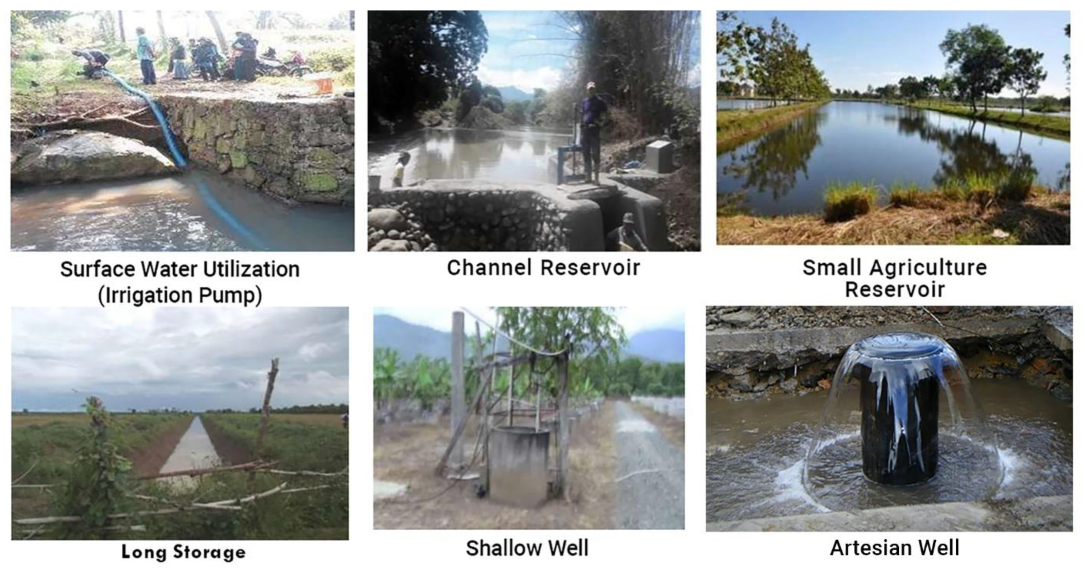
  66. Fagi, A.M.; Syamsiah, I. The Prospect of Small Agricultural Reservoirs in Supporting the Sustainability of Rainfed Land Productivity. In Proceedings of the Agricultural Meteorology Simposium III: Climate, Technology, and Sustainable Agriculture Development in Eastern Indonesia, Malang, Indonesia, 20–21 August 1991; pp. 195–210. (In Indonesian). [Google Scholar]
  67. Syamsiah, I. Potential, Construction Technique, and Utilization of Small Reservoir. In Proceedings of the Seminar of Research Results 1989/1990, Balittan, Indonesia, 3–6 September 1990; Indonesian Food Crop Research Agency: Subang, Indonesia, 1990. (In Indonesian). [Google Scholar]
  68. Syamsiah, I.; Fagi, A.M. Small Agricultural Reservoir Technology. In Proceedings of the Seminar Pengelolaan Tata Air dan Pemanfaatannya dalam Satu Kesatuan Toposekuens, Cilacap, Indonesia, 7–8 October 1993; Perhimpunan Meteorologi Pertanian Indonesia: Bogor, Indonesia, 1993. (In Indonesian). [Google Scholar]
  69. Gould, J. Designing Water Storage for Rainwater Harvesting System. In International Training Course on Rainwater Harvesting and Utilization; Water Resources Bureau of Ganzu Province-International Rainwater Catchments System Association-Ganzu Research Institute for Water Conservancy; China Agriculture University and Agriculture Academy of Ganzu Province: Lanzhou, China, 2003. [Google Scholar]
  70. Rejekiningrum, P.; Apriyana, Y. Design and Implementation of Solar Pump Irrigation Systems for the Optimization of Irrigation and Increase of Productivity. Proc. IOP Conf. Ser. Earth Environ. Sci. 2021, 622, 012046. [Google Scholar] [CrossRef]
  71. Irianto, G. Jakarta Citizens Drowns Jakarta. Hari. Kompas, 31 January 2003; p. 4. (In Indonesian) [Google Scholar]
  72. Irianto, G. Is It True That in 2002 There Will Be an El-Nino with a Weak Intensity? Hari. Kompas, 22 June 2002; p. 10. (In Indonesian) [Google Scholar]
  73. Apriyana, Y.; Pramudia, A.; Koswara, M.R.S.; Misnawati. Adjusting Planting Time Using Water Balance and Rainfall Prediction Approaches. Proc. IOP Conf. Ser. Earth Environ. Sci. 2021, 648, 012108. [Google Scholar] [CrossRef]
  74. Dewi, E.R.; Susanti, E.; Apriyana, Y. Planting Time Options to Improve Rice Productivity Based on the Integrated KATAM Recommendations. Proc. IOP Conf. Ser. Earth Environ. Sci. 2021, 648, 012105. [Google Scholar] [CrossRef]
  75. Irianto, G.; Duchesne, J.; Forest, F.; Perez, P.; Cudennec, C.; Prasetyo, T.; Karama, S. Rainfall and Runoff Harvesting for Controlling Erosion and Sustaining Upland Agriculture Development. In Proceedings of the 10th International Soil Conservation Organization Conference, West Lafayette, IN, USA, 23–28 May 1999; Purdue University: West Lafayette, IN, USA, 2001. [Google Scholar]
  76. Pujilestari, N.; Irianto, G.; Heryani, N. Increasing Productivity of Dry Land through the Construction of a Multilevel “Channel Reservoir” (Case Study in the Bunder Sub-Watershed, Gunungkidul Regency, DIY Province); Indonesian Center for Animal Research and Development: Bogor, Indonesia, 2002. (In Indonesian) [Google Scholar]
  77. Karama, S. Harvesting Rain and Surface Streams to Overcome Floods and Droughts and Developing Leading Commodities. Integrated Research Report VII of Agricultural Product Technology; Ministry of Environment: Jakarta, Indonesia, 2003. (In Indonesian) [Google Scholar]
  78. Heryani, N.; Irianto, G.; Sutrisno, N.; Surmaini, E. Research and Development of Water Resources Management to Increase Dryland Productivity in Cianjur Regency, West Java. Final Research Report (Unpublished); Kementerian Pertanian: Bogor, Indonesia, 2003. [Google Scholar]
  79. CIRAD French Agricultural Research Centre for International Development. Research-Development Activities: “Farming System Intensification on Catchments in Jawa Tengah and DI Yogyakarta Provinces”; CIRAD French Agricultural Research Centre for International Development: Paris, France, 2004. [Google Scholar]
  80. Heryani, N.; Kartiwa, B.; Irianto, G.; Bruno, L. Utilization of Water Resources to Support Dry Land Farming Systems: A Case Study in the Bunder Sub-Watershed, Oyo Watershed, Gunungkidul, DIY. In Proceedings of the One Day Seminar of Agroclimate Role in Supporting Dryland Farming Development Seminar Sehari Peranan, Bogor, Indonesia, 17 October 2001; Pusat Penelitian dan Pengembangan Tanah dan Agroklimat: Bogor, Indonesia, 2001. (In Indonesian). [Google Scholar]
  81. Heryani, N.; Irianto, G.; Pujilestari, N. Water Harvesting to Create a Sustainable Farming System (Experience in Wonosari, Special Region of Yogyakarta). Bul. Agron. 2002, 30, 45–52. (In Indonesian) [Google Scholar]
  82. Heryani, N.; Irianto, G.; Pujilestari, N. Efforts to Increase Water Availability to Reduce the Risk of Drought and Increase Land Productivity. In Proceedings of the National Seminar of Agronomy and Agriculture Exhibition, Bogor, Indonesia, 29–30 October 2002; Perhimpunan Agronomi Indonesia: Bogor, Indonesia, 2002. (in Indonesian). [Google Scholar]
  83. Heryani, N.; Sawiyo; Kartiwa, B.; Sudarman, K.; Rejekiningrum, P.; Apriyana, Y. Management of Climate and Hydrological Resources to Support Primatani. Final Research Report (Unpublished); Kementerian Pertanian: Bogor, Indonesia, 2005. (In Indonesian) [Google Scholar]
  84. Heryani, N.; Sawiyo; Pujilerstari, N. Management of Climate and Hydrological Resources to Support Primatani Semin Sub-District, Gunungkidul District, DIY Province. Final Research Report (Unpublished); Kementerian Pertanian: Bogor, Indonesia, 2006. (In Indonesian) [Google Scholar]
  85. Heryani, N.; Talaohu, S.H.; Sudarman, K.; Nasrullah. Development of Methods for Determining Criteria for the Design of Rain and Runoff Harvesting Systems to Reduce Flood and Drought Risks > 30%. Ministry of Research and Technology Research Final Report; Ministry of Research and Technology Republic of Indonesia: Bogor, Indonesia, 2010. [Google Scholar]
  86. Sawiyo; Kartiwa, B.; Sosiawan, H.; Sudarman, K. Water Harvesting with Channel Reservoir and Application of Supplementary Irrigation to Increase Land Productivity (Unpublished); Kementerian Pertanian: Bogor, Indonesia, 2008. (In Indonesian) [Google Scholar]
  87. Sutrisno, N.; Sawijo; Pujilestari, N. Water Manajemen and Development of Sustainable Agriculture to Mitigate Flood and Drought, a Research Report; Kementerian Pertanian: Bogor, Indonesia, 2003. (In Indonesian) [Google Scholar]
  88. Dariah, A.; Heryani, N. Empowerment of Suboptimal Dryland to Support Diversification and Food Security Policies. J. Sumberd. Lahan 2014, 8, 1–16. (In Indonesian) [Google Scholar]
  89. Haryati, U. Supplemental Irrigation and Its Implementation Strategy in Dryland Agriculture. Sinar Tani 2011, 6, 3413. (In Indonesian) [Google Scholar]
  90. Kurnia, U. The Prospect of Irrigation for Dryland Seasonal Crops. J. Litbang Pertan. 2004, 23, 130–138. (In Indonesian) [Google Scholar]
  91. Machado, S.; Petrie, S.; Rhinhart, K.; Ramig, R.E. Tillage Effects on Water Use and Grain Yield of Winter Wheat and Green Pea in Rotation. Agron. J. 2008, 100, 154–162. [Google Scholar] [CrossRef]
  92. Van Duivenbooden, N.; Pala, M.; Studer, C.; Bielders, C.L.; Beukes, D.J. Cropping Systems and Crop Complementarity in Dryland Agriculture to Increase Soil Water Use Efficiency: A Review. Neth. J. Agric. Sci. 2000, 48, 213–216. [Google Scholar] [CrossRef] [Green Version]
  93. Sosiawan, H.; Sudarman, K.; Nuraida, N.L.; Dariah, A. Water Use Efficiency Technology to Increase Planted Area and Planting Index in Bima Regency, East Nusa Tenggara. In Proceedings of the National Seminar of Land Resource Information System and Mapping to Support Food Self Suficiency, Bogor, Indonesia, 29–30 July 2015; Indonesian Center for Agricultural Land Resources Research and Development: Bogor, Indonesia, 2015. (In Indonesian). [Google Scholar]
  94. Sudarman, K.; Kartiwa, B.; Trinugroho, W. Water Management in Dryland-Dry Climates—A Research Report; Kementerian Pertanian: Bogor, Indonesia, 2011. (In Indonesian) [Google Scholar]
  95. Sosiawan, H.; Sudarman, K.; Trinugroho, W. Research on Water Management in Dry Climate Dry Land in NTB and NTT. Final Research Report; Kementerian Pertanian: Bogor, Indonesia, 2012. (In Indonesian) [Google Scholar]
  96. Sosiawan, H.; Sudarman, K.; Adi, S.H.; Kartiwa, B.; Heryani, N.; Rejekiningrum, P.; Syahbuddin, H.; Hamdani, A.; Trinugroho, W.; Aprilyanto, A.; et al. Research and Development of a Food Smart Village Model on Dryland for Climate Change Adaptation; Kementerian Pertanian: Bogor, Indonesia, 2014. (In Indonesian) [Google Scholar]
  97. Sosiawan, H.; Heryani, N.; Sutrisno, N.; Rejekiningrum, P.; Kartiwa, B.; Sudarman, K.; Sawiyo; Pujilestari, N.; Adi, S.H.; Hamdani, A. Food Smart Village as a Model for Integrated Water Resources and Climate Management Approaches to Reduce the Risks of Dryland Agriculture; Kementerian Pertanian: Bogor, Indonesia, 2013. (In Indonesian) [Google Scholar]
  98. Sosiawan, H.; Kartiwa, B.; Sutrisno, N.; Rejekiningrum, P.; Sudarman, K. Research on Integrated Climate and Water Resource Management Technology in Various Agroecosystems to Support UPSUS PAJALE, Red Chili and Cacao; Kementerian Pertanian: Bogor, Indonesia, 2016. (In Indonesian) [Google Scholar]
  99. Indonesian Center for Agricultural Land Resources Research and Development. Small Agricultural Reservoir and Water Infrastructures Implementation 2017. Coordination Meeting Material (Unpublished); Indonesian Center for Agricultural Land Resources Research and Development: Bogor, Indonesia, 2017. (In Indonesian) [Google Scholar]
  100. Rejekiningrum, P.; Kartiwa, B. Contribution of Water Harvest Infrastructure Development to Increasing Farmers Income and Welfare. Risal. Kebijak. Pertan. dan Lingkung. Rumusan Kaji. Strateg. Bid. Pertan. dan Lingkung. 2020, 7, 37–51. (in Indonesian). [Google Scholar] [CrossRef]
  101. Indonesian Center for Agricultural Land Resources Research and Development. Reorientation of National Irrigation Infrastructure Development Policy. Coordination Meeting Material (Unpublished); Indonesian Center for Agricultural Land Resources Research and Development: Bogor, Indonesia, 2017. (In Indonesian) [Google Scholar]
  102. Indonesian Center for Agricultural Land Resources Research and Development. Small Agricultural Reservoir as Solution to Increase National Food Production. BAPPENAS Discussion Material; Indonesian Center for Agricultural Land Resources Research and Development: Bogor, Indonesia, 2017. [Google Scholar]
Figure 1. Distribution of rainfall in several dryland regions in Indonesia: (a) Gunungkidul, (b) Maros, (c) Bima, and (d) Kupang.
Sustainability 14 11672 g001
Figure 2. Map of climate characteristics in (a) Gunungkidul, DI Yogyakarta; (b) Maros, South Sulawesi; (c) Bima, West Nusa Tenggara; (d) Kupang, East Nusa Tenggara [36,37].
Sustainability 14 11672 g002
Figure 3. Multiple models for water-harvesting infrastructure.
Sustainability 14 11672 g003
Figure 4. The effect of irrigation dose and organic matter on dry shelled maize at the research site in the village of Mbawa, Donggo District, Bima Regency [93].
Sustainability 14 11672 g004
Table 1. Distribution of existing drylands and extensification of rice, maize, and soybean planting areas on drylands.
NoProvinceDryland (Ha)Total
ExistingExtensified
1Aceh358,932416,328775,260
2North Sumatra782,914321,7641,104,678
3Riau446,768390,892837,660
4Riau Islands55,979141,516197,495
5Bangka Belitung Islands81,894328,127410,021
6West Sumatra209,84477,766287,610
7Jambi512,125589,4071,101,533
8Bengkulu214,25648,442262,698
9North Sumatra1,474,722384,3911,859,113
10Lampung468,048188,117656,165
11Jakarta Capital Region17620196
12Banten122,71325,479148,192
13West Java373,53764,088437,624
14Central Java1,175,655324,2241,499,879
15East Java1,410,744323,4081,734,152
16Special Region of Yogyakarta72,56317,57990,142
17Bali58,60693,137151,743
18West Nusa Tenggara73,389130,561203,950
19East Nusa Tenggara4,08392,96297,045
20East Kalimantan187,3041,958,1862,145,490
21Central Kalimantan395,1381,548,7781,943,916
22North Kalimantan39,165336,917376,082
23South Kalimantan155,18096,253251,433
24West Kalimantan296,614659,023955,636
25North Sulawesi118,44221,652140,094
26Central Sulawesi279,504717,488996,992
27Southeast Sulawesi256,045411,384667,429
28South Sulawesi241,00877,567318,575
29West Sulawesi63,00879,072142,080
30Gorontalo85,45556,789142,243
31North Maluku142,385168,001310,387
32Maluku139,646683,444823,090
33West Papua70,4331,397,3411,467,774
34Papua115,1491,878,5491,993,699
Grand Total10,481,42414,048,65224,530,076
Source: BBSDLP (2018) [22].
Table 2. Dryland area and distribution for the expansion of rice, maize, and soybean planting areas based on forest area status.
NoProvinceExtensificationTotal
Other Land Use AreasConvertible Production ForestProduction Forest
1Aceh287,7614276124,291416,328
2North Sumatra140,76432180,968321,764
3Riau37,491164,288189,113390,892
4Riau Islands43,09587,34111,080141,516
5Bangka Belitung Island46,63125,442569477,766
6West Sumatra429,781554159,073589,407
7Jambi164,082166163,879328,127
8Bengkulu231,16210,877142,351384,391
9South Sumatra41,388745630948,442
10Lampung101,978-86,139188,117
11Jakarta Capital Region20--20
12Banten11,857-13,62225,479
13West Java22,563-41,52464,088
14Central Java128,679-195,545324,224
15East Java133,217-190,192323,408
16Special Region of Yogyakarta16,559-102017,579
17Bali77,631414711,35893,137
18West Nusa Tenggara80,933-49,628130,561
19East Nusa Tenggara62,701982416,35488,878
20East Kalimantan879,75137,7021,040,7331,958,186
21Central Kalimantan269,249484,918794,6101,548,778
22North Kalimantan166,51015,349155,059336,917
23South Kalimantan34,592253159,13196,253
24West Kalimantan462,1956637190,190659,023
25North Sulawesi19,459-219321,652
26Central Sulawesi242,80139,551435,137717,488
27South-east Sulawesi215,41652,318143,650411,384
28South Sulawesi56,502236918,69777,567
29West Sulawesi28,999732942,74579,072
30Gorontalo48,5911741645756,789
31North Maluku39,88053,97274,150168,001
32Maluku64,897386,236232,310683,444
33West Papua136,315553,978707,0481,397,341
34Papua285,130597,532995,8871,878,549
Grand Total5,008,5802,549,8556,486,13714,044,572
Source: BBSDLP (2018) [22].
Table 3. Service area targets (ha) of 2017 water-harvesting infrastructure development per island.
NoIslandChannel
Reservoir
Small
Agriculture Reservoir
Long
Storage
River Water Use (by Pump)Shallow WellTotal
1Sumatra312,533218,32713,500655,56165551,206,476
2Java75,595130,69529,044486,0122989724,335
3Kalimantan132,866282,16713,230912,05323861,342,702
4Sulawesi68,18087,54919,175428,5375431608,872
5Bali and Nusa Tenggara15,57630,778884758,5584117117,876
6Maluku and North Maluku5656399949488384122924,216
7Papua16635631229517,460163228,681
Total612,069759,14791,0392,566,56524,3394,053,158
Source: BBSDLP (2017b, 2017c) [101,102].
Table 4. Advantages of constructing small agriculture reservoirs and other water storage structures for rice paddies.
Type of Water InfrastructureTarget (ha)No. of UnitsUnit Price (IDR/Ha)Investment
(Million IDR)
Gross Income
(Million IDR)
Profit
(Million IDR)
Channel Reservoir612,06887814,500,0002,754,30612,339,2899,584,983
Small Agriculture Reservoir24,33910184,000,00097,354490,666393,312
Long Storage91,03958324,000,000364,1541,835,3381,471,184
River Water Use2,566,565170,4835,950,00015,271,06451,741,95736,470,894
Shallow Well759,14775,3285,400,0004,099,39115,304,39411,205,003
Total4,053,158261,442 22,586,26981,711,64459,125,376
Source: BBSDLP (2017b, 2017c) [101,102].
Table 5. Advantages of constructing small dams and other water storage structures for maize.
Type of Water InfrastructureTarget (ha)No. of
Units
Unit Price (IDR/Ha)Investment
(Million IDR)
Gross Income
(Million IDR)
Profit
(Million IDR)
Channel Reservoir612,06887814,500,0002,754,30611,017,2248,262,918
Small Agriculture Reservoir24,33910184,000,00097,356438,102340,746
Long Storage91,03958324,000,000364,1561,638,7021,274,546
River Water Use2,566,565170,4835,950,00015,271,06246,198,17030,927,108
Shallow Well759,14775,3285,400,0004,099,39413,664,6469,565,252
Total4,053,158261,442 22,586,27472,956,84450,370,570
Source: BBSDLP (2017b, 2017c) [101,102].
Table 6. Advantages of constructing small dams and other water storage structures for shallots.
Type of Water InfrastructureTarget (ha)No. of
Units
Unit Price (IDR/Ha)Investment
(Million IDR)
Gross Income
(Million IDR)
Profit
(Million IDR)
Channel Reservoir612,06887814,500,0002,754,30648,965,44046,211,134
Small Agriculture Reservoir24,33910184,000,00097,3561,947,1201,849,764
Long Storage91,03958324,000,000364,1567,283,1206,918,964
River Water Use2,566,565170,4835,950,00015,271,062205,325,200190,054,138
Shallow Well759,14775,3285,400,0004,099,39460,731,76056,632,366
Total4,053,158261,442 22,586,274324,252,640301,666,366
Source: BBSDLP (2017b, 2017c) [101,102].
Publisher’s Note: MDPI stays neutral with regard to jurisdictional claims in published maps and institutional affiliations.

