Article

Potentials for Sponge City Implementation in Sub-Saharan Africa

Institute of Sanitary Engineering and Waste Management, Leibniz University Hannover, 30167 Hannover, Germany
*
Author to whom correspondence should be addressed.
Sustainability 2022, 14(18), 11726; https://doi.org/10.3390/su141811726
Submission received: 2 August 2022 / Revised: 26 August 2022 / Accepted: 9 September 2022 / Published: 19 September 2022

Abstract

:
Despite the growing interest in implementing sponge cities (SPC), their potential is not yet being tapped in many fast-growing Sub-Saharan African cities. This is remarkable because SPC interventions can contribute considerably to increasing water safety and availability in a city. By means of a three-stage potential assessment, this study provides the first analysis of what concrete options can be identified for implementing the SPC concept in Sub-Saharan cities. The methodology was filled with information obtained especially from expert interviews, literature reviews, and satellite imagery. Thus, the analysis also considers what obstacles impede SPC implementation, and, in particular, what technical and socioeconomic constraints need to be taken into account. The cities of Hawassa (Ethiopia), Beira (Mozambique), Kigali (Rwanda), Ouagadougou (Burkina Faso), and Cotonou (Benin) are examined in detail. Additionally, a local SPC implementation was conceptualized and evaluated for two districts in Ouagadougou and Cotonou. The first finding is that, when geographical and socioeconomic aspects such as climatic patterns, migration flows, health risks, and existing infrastructure are sufficiently taken into account, SPC interventions would massively help African cities to mitigate current and urgent challenges such as water scarcity and urban flooding. In terms of water safety, the second key finding is that rainwater harvesting solutions at the household level could be implemented quickly; however, there would be substantial difficulties such as lack of financing and maintenance as well as claims of ownership, especially in informal settlements and slums. Thus, it seems quite promising to directly strive for a rapid “centralization” of SPC implementation in individual neighborhoods. This neighborhood approach paves the way for SPC measures to receive public acceptance and constant maintenance. When this mosaic of implementations comes together, many individual instances of SPC implementation can help to improve urban resilience and living conditions for the city dwellers as is here demonstrated for the districts in Cotonou and Ouagadougou.

1. Introduction

The urban development trends in Africa show a rapid city growth. By the year 2050, the world’s population will have risen to 9.5 billion people with 66.3% of them living in cities [1]. In Africa, this trend for growing urban areas is particularly strong, leading to a bigger demand for housing and resources such as water that cannot always be met. With poverty rising and many people living under inadequate conditions, the need to address water scarcity and proper wastewater treatment is crucial. In 2018, 56% of the urban population did not have access to piped water [2]. According to an assessment made by the UN-Habitat (2016), 55.9% of the urban population in Sub-Saharan Africa was living in slums in 2014 [3]. In addition to this problem and considering the heterogeneous characteristics of the African continent, different countries are highly affected by climate change with various impacts and therefore challenges, and it should be kept in mind that due to the lack of adaptive capacities of their inadequate housing, the low-income population is especially affected by climate change [4]. Effects such as extended dry periods and extreme rainfall events have been predicted by various scientists (e.g., [5]). In addition, the region under consideration is particularly vulnerable to soil erosion [6], and stormwater discharge in urban areas is prone to be polluted through non-point sources attributed to typical urban surface design and associated erosion effects. This consequently leads to increased surface water degradation which could be reduced by green infrastructure elements such as infiltration basins, vegetated roofs, and revegetation. In regions such as Europe or the US, the need to improve stormwater quality has attracted increasing attention [7,8]. The issue is how African cities can future-proof themselves and how the environmental impacts can be reduced, especially in light of the trends outlined above. According to Bahri et al. (2016), regions with a high urbanization growth rate and a lack of infrastructure, as in the case of African cities, especially offer an opportunity for the implementation of innovative solutions based on integrated urban water management [9], p. 24.
Indeed, blue-green infrastructures will help to mitigate the predicted extreme climatic conditions in cities and–mainly based on water-sensitive urban design–adapted urban rainwater harvesting solutions might even improve the water supply situation in many African cities. Du Toit et al. documented perceptions of green infrastructure (GI) and ecosystem services. According to their data collection conducted in 2018, only in 38% of the Sub-Saharan countries have studies dealing with green infrastructure and ecosystem services been documented, with most of them occurring in South Africa [10], pp. 249–261. Nevertheless, there is a growing interest in the implementation of GI in Sub-Saharan cities, particularly for regions with insufficient access to conventional infrastructural and ecological services [11].
Yet it is worth going even one step further. The Sponge City concept can contribute considerably to increasing water availability and security of the water supply in a city. The Sponge City concept is a globally recognized approach that has several terminologies in its implementation (water-wise cities, blue-green cities, water-sensitive urban design [WSUD], low-impact development, etc.). However, the term Sponge City (SPC) very aptly describes the main purpose of this urban planning concept. In addition to the traditional “grey” drainage systems, a blue-green water management infrastructure is created, holistically allowing rainwater to be collected, treated, stored, and released at a later time as a supplementary urban water resource [12]. The concept is therefore thought to be highly interesting for African cities, especially when considering widespread socioeconomic constraints, yet there are, surprisingly, barely any scientific articles about the implementation of integrated urban water management allowing for the use of rainwater as an additional water source based on the SPC concept in the Sub-Saharan Africa Region. Other objectives are also tackled by the SPC concept, including biodiversity conservation, regulation of the urban microclimate by means of improved heat protection, and the provision of recreation through the implementation of plenty of public green spaces. Fast-growing urban areas in (sub-)tropical climate zones, like Sub-Saharan African cities can especially benefit from these positive effects [13].
Surprisingly, the topic of sponge cities in Africa has so far found little to no resonance [11]. The SPC concept has the concrete potential to help overcome water-related urban problems in general and water supply problems in African cities in particular. Therefore, it is now very high time to present the how SPC implementation is possible and the basic conditions which have to be considered.
This article attempts the first approach to how this can be achieved in Africa and here in the area south of the Sahara. In concrete terms, the main objective of this paper is to elaborate upon the general requirements of SPC infrastructure elements and develop an SPC concept for select cities in Sub-Saharan Africa. Therefore, the geographical and socioeconomic site conditions in five pilot cities (Hawassa, Beira, Kigali, Cotonou, and Ouagadougou) were analyzed. Based on these findings, an adapted SPC concept was carried out for districts in Cotonou and Ouagadougou.

2. Data Availability and Methods

2.1. Data

2.1.1. Literature Research

All current literature databases were tapped. Keywords, such as ‘Sub-Saharan Africa’, ‘Green Infrastructure’, ‘climate’, ‘urban development’, and ‘(rain-) water management’ were used. In particular, the reports of the United Nations—including UNEP and UN-Habitat—were used to document the inventory of the cities studied.

2.1.2. Expert Interviews

The poor situation with regard to the literature was compensated by expert interviews. In this context, employees of German institutions of international development cooperation with excellent expertise in financing and implementing projects in Sub-Saharan Africa were consulted. The institutions include the KfW (Kreditanstalt für den Wiederaufbau, Frankfurt am Main, Germany), the GIZ (Gesellschaft für Internationale Zusammenarbeit, Bonn, Germany) and the engineering office Inros Lackner SE.
The official contact persons for former and current construction projects carried out by the GIZ and the KfW as well as commissioned engineering offices were asked for an interview via email. Guiding questions were created in advance in order to obtain targeted and comparable information. The data collection addressed the following key questions. How can the SPC be implemented considering the existent challenges and conditions? Where should measures be built in order to achieve the best performance? Which measures can be implemented? Which measures aiming at the same idea as SPC already exist in Sub-Saharan cities? A total of 9 of the 28 experts contacted agreed to be interviewed. All interviewed persons have high-level responsibilities in the implementation of development cooperation projects in the countries under consideration, and here in the field of water. GIZ is a highly acknowledged international development service provider with nearly 25,000 employees that are active in around 120 countries. The representatives of the German KfW Development Bank represent a development institution with comprehensive financing competence and additionally contribute development policy expertise and many years of international experience. All contacts for projects in the Sub-Saharan Africa region were invited by mail to a short online meeting. The experts were informed about the topic, purpose, and background of this study. If the interview was accepted, a guide of the questions was provided to the participants in advance. These questions were related to geographic conditions (e.g., soil conditions, precipitation, flooding and drought events, etc.), the state of urban infrastructure (e.g., current construction projects, water supply systems, water accessibility, urban structure, etc.), and personal assessment of green infrastructure measures and their feasibility. The conversations took place via virtual platforms such as Teams, Jitsi, WhatsApp, etc. Most of the respondents were in their operation countries, and virtual platforms offered a cost-effective tool to conduct the interviews. Due to the low number of interview partners and the individual character of their answers, the data collected are considered to be subjective and not universally valid. Furthermore, the comprehensiveness of the data was also influenced by the quality of the internet connection, the respondent’s expertise, and the duration of the interviews.

2.1.3. Others

Supplementary topographical maps and Google Maps were used to carry out area analysis in the investigated areas.
Additionally, with the help of the open-source program QGIS (Version 3.20.3–Odense, available online: https://www.qgis.org/en/site/forusers/download.html, accessed on 11 September 2021), the proposed SPC intervention was visualized.

2.2. Methods

2.2.1. A Three-Stage Potential Assessment Process

Focusing on the idea of the SPC concept, the initial assessment/analysis follows an inductive scheme; therefore, the procedure was carried out in the following 3 steps illustrated in Figure 1.
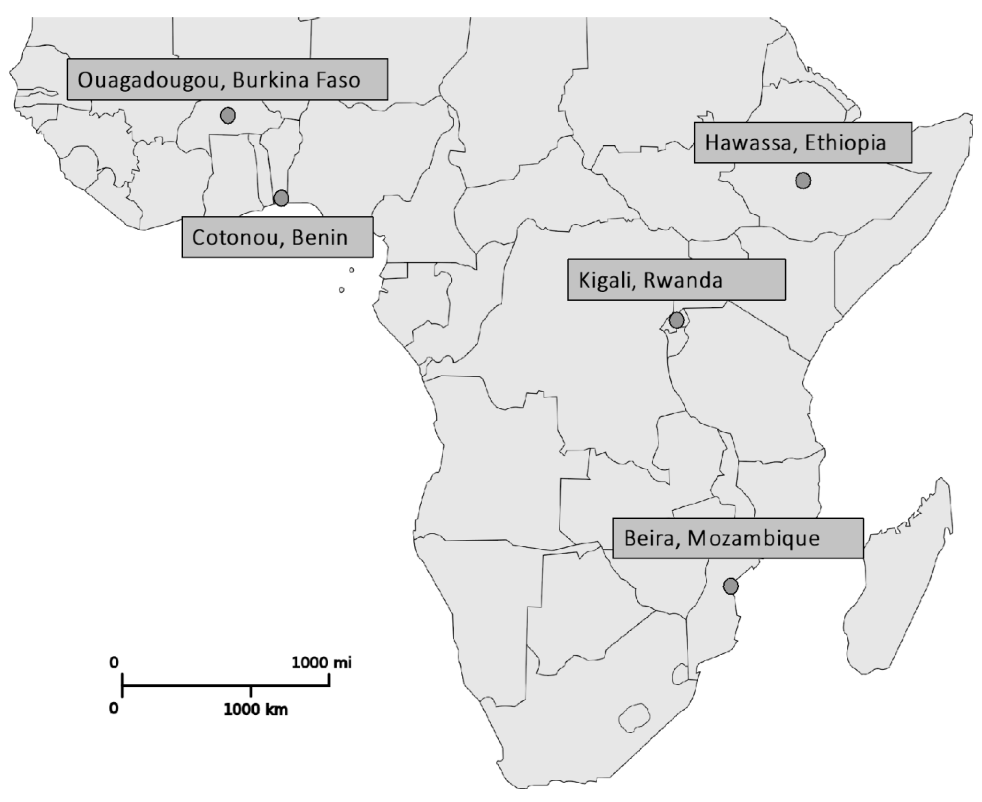
Due to the heterogeneity of the urban regions in Sub-Saharan Africa highlighted in Table 1, five pilot cities located over the whole study area were chosen to identify site conditions including geography and socioeconomics, as shown in Figure 2.
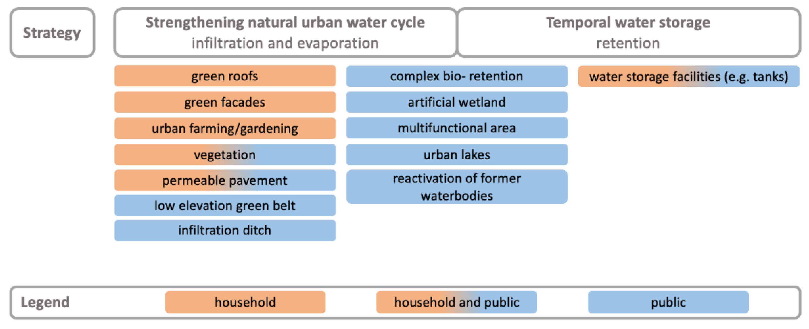
Based on the results of the first step, requirements were set up to develop adapted and resilient SPC implementations. Exemplary, concrete SPC concepts were presented for two city districts in different pilot cities. Therefore, these districts were examined more precisely in terms of land use and topography. There is already a wealth of experience of sponge city implementation worldwide, particularly in the design of individual urban neighborhoods. Flagship projects are, for example-the “Waterplein” in Rotterdam, the ABC (Active, Beautiful, Clean Waters Programme) master plan in Singapore, and the implementation of a green network in Melbourne [14]. The implementation approaches considered in the case studies are especially based on previous experience gained in Asia, Europe, the USA, and Australia and were deliberately embedded in an African urban context. Thus, the selected types of SPC interventions were classified according to their benefits in terms of urban water management. Subsequently, the interventions were assessed in terms of whether the application is feasible at the household level and in public places. Factors such as the technical requirements, the reach and size of the measure, existing applications of SPC projects, and water retention capacity were considered in the evaluation process (Figure 3).
The evaluation of the SPC concept in Sub-Saharan African cities using a cost–benefit analysis was not possible on the basis of the available data.
In order to carry out an economic evaluation of preventive and sustainable infrastructural measures with social benefits, such as elements of SPC, data must be available for monetized intangible aspects (e.g., temperature modification and social wellbeing). In addition, data on the investment and maintenance costs over the whole life cycle of the interventions in the Sub-Saharan cities were needed. Thus, the lack of existent implementation of SPC in the investigation area from which to gain experience complicated economical assessment. As an alternative, the cost–benefit analysis was replaced by a general comparison of profit and expenses using scientific results and key figures, e.g., the runoff coefficient and albedo. Avoidance costs were used to describe the benefits of preventive actions.

2.2.2. Site Selection and Delimitation

As shown in Table 1, the chosen cities strongly differed from each other regarding climatic and geographical conditions as well as their exposure to climate change. Intermediate and smaller cities were not selected due to the lack of information. The chosen cities, being spread across the African continent, include Hawassa (Eastern Africa), Beira (Southern Africa), Rwanda (Central Africa), Cotonou (West Africa), and Ouagadougou (Sahel zone). The country and city selection mainly depended on the information available and the expertise of the contacted experts. Furthermore, the data available for characterizing the regions strongly differ from each other, and this is why the site conditions cannot be compared directly.
Concrete measures targeting the concept of SPC were designed for districts in Cotonou and Ouagadougou. Due to local expertise gained during a personal stay in the vicinity of Cotonou over a period of one year in 2014/2015, realistic measures in this region can be better assessed.
Considering the rainy climate in Cotonou, Ouagadougou was selected as a contrast. During the dry season, the climatic conditions of this city are an example of an arid region. Beira represents an extreme case making long-term implementations of SPC difficult due to recurring tidal flooding and cyclones. Kigali and Hawassa are not studied further due to limited scientific data compared to the other cities. Based on satellite images from Google Earth, city districts in Cotonou and Ouagadougou were chosen for further investigation. It is assumed that the high density of public buildings at these sites results in a high degree of surface sealing and more room for financial manoeuvres in contrast to private households. Therefore, mainly public places are considered for the planification of proposed SPC elements. The uneven delimitation of the study areas within Cotonou and Ouagadougou (2.3 km2 and 2.6 km2, respectively) is a result of their particular spatial characteristics.
The first study region is situated in the southeastern portion of Ouagadougou near the airport and covers an area of approximately 2.6 km2 (1.3 km × 2.0 km). The selected district, called “Patte d’Oie” is well structured and characterized by a high building density including public places such as restaurants, stores, schools, churches, and mosques [27]. Only a few vegetated areas can be found, and the streets are broadly unfortified. The lowest topographical elevation, with less than 304 masl, can be found at the water body, as shown in Figure 4.
The second area of investigation covers the biggest market in West Africa, Dantokpa. There, goods such as food, textiles, second-hand clothes, and animals are sold. The market is situated next to the Lagoon of Cotonou. Except for the buildings in the textile area, the stalls are mainly equipped with corrugated metal roofs and sunshades. Furthermore, the market’s ground is partly unpaved. The total investigation area includes 2.3 km2 (1.2 km × 1.9 km), from which the Dantokpa market covers approximately 0.2 km2. Currently, the government is financing the transformation of the market, which will be demolished and split into individual markets across the city in order to alleviate traffic [28]. There is no further information about the construction work available. According to Google Maps, most of the surrounding buildings are primarily used for business (e.g., stores, restaurants) with paved main streets and parking spaces for minibuses, vehicles, and motorcycle cabs. Green areas are very rare in this district. The selected area is shaped by a homogenous elevation of mainly less than 5 masl, shown in Figure 4.
Furthermore, it can be noted that Dantokpa has significantly higher land sealing compared to Patte d’Oie.
For the proposed concept, it is assumed that long-term interventions of SPC in public places and social institutions such as schools, sport fields, markets, etc., are easier to manage. At the private household level, general recommendations are formulated. Due to a lack of data, it was not possible to fully classify land use throughout the entire study area.

3. Results

3.1. Step 1: Identification of Conditions

3.1.1. Hawassa, Ethiopia

Located to the south of Addis Ababa, Hawassa is one of the fastest growing cities in Ethiopia. The region is characterized by a tropical climate with seasonal rainfall and an average temperature of 26.4 °C during the daytime. April, May, September, and October usually present the highest rainfall, with an average of 150 mm per month and a humidity of more than 64%. December, January, and February are the driest months, with a monthly precipitation of less than 28 mm and a humidity of less than 55% [19].
Within a decade Hawassa’s population has increased by more than 100%, a growth spurt attributable to the established tourism branch and a major university. Additionally, the industry park at the city’s periphery has been growing, consequently attracting the rural population with the newly available work opportunities. The branches include textile, soft drinks, and brewery industries. The soil is described as mostly sandy [25,31]. Furthermore, Gashu and Gebre-Egziabher (2019) estimate that Hawassa’s green infrastructure (such as parks, green roofs, lakes, and sport fields) covers 21.96% of the urban surfaces [32]. Nevertheless, the city’s (waste-) water and sewage systems cannot fulfil the increasing needs of the growing population. It is estimated that the existent water supply network, extracted from groundwater, can meet only a quarter of the demand. Furthermore, the lack of proper sewage supply results in high anthropogenic impacts on the environment, such as the discharge of polluted urban surface runoff during rainfall events, which affects the water quality in neighboring Lake Hawassa [25].

3.1.2. Beira, Mozambique

The third-largest city in Mozambique, Beira is situated at the coast of the Indian Ocean in the southeast of Africa [33]. The humid climate is characterized by high temperatures (30 °C–32 °C) between October and March with lower temperatures (25 °C–26 °C) in July and August. The annual rainfall is usually less than 2500 mm with a monthly precipitation between 200–300 mm from December to March. Furthermore, the precipitation patterns in the driest months of May to September do not exceed 50 mm [34]. The terrain is mainly flat with an average elevation of 6 masl [33].
By the year 2035, the annual growth rate of the city is projected to be between 2.25 to 4.25% [33]. According to the District Statistics of Beira (2008), households without adequate water access use water sources from pits, lakes, rivers, and public drinking fountains rather than rainwater [35]. The UN Habitat (2020) reports that nowadays more than 45% do not have access to steady clean water [33]. According to the estimation of the UN Habitat (2020) and from an economic point of view, rainwater harvesting would be profitable for households that are far away from existing grids [33,36]. The city is strongly affected by the impacts of climate change such as sea level rise, cyclones, and flooding. Several studies report that Beira is highly vulnerable to climatic threats [5,33]. In March 2019 the city was affected by Cyclone Idai, which flooded 90% of the city’s area [33]. In the Goto settlement, interventions have been utilized to counteract regular tidal flooding which share the principle of the SPC concept. To improve retention and drainage capacity, the Chiveve River is rehabilitated and used as a drainage channel. Additionally, the river’s catchment area is protected by a flood barrier or through reforestation of mangroves. The informal settlement and the market are particularly highly affected by the accumulation of waste threatening the drainage systems [37].

3.1.3. Kigali, Rwanda

Rwandans’ climate is shaped by two rainy seasons (February to April and October to January). The driest months, including June and July, usually not exceed precipitation of above 15 mm. The highest monthly precipitation rate occurs in April with 146 mm. The average temperature is 21 °C, while the maximum temperatures do not exceed 27 °C [20].
In 2011, more than 9% of the Rwandan population was living in Kigali, one of the fastest-growing cities in East Africa [38]. Due to the socioeconomic achievements within the last three decades, the political and economic capital has become a model for other Sub-Saharan African cities. According to the World Bank (2021), Rwanda is pushing to become a Middle-Income Country by the year of 2035 and a High-Income Country in 2050 by establishing national strategies to aim at the UN’s Millennium Development Goals [39], p. 202. The development can be observed by the GNI (Gross National Income) per capita, which has tripled from 2000 to 2017 [40]. According to the indicators set up in the UN’s Millennium Development Goals, 53.2% of the Rwandan urban population (1.8 million) lived in slums in 2014 [41]. According to the analysis of the built-up area of Kigali made by Florczyk et al. (2019), there has been a substantial increase in population with a relatively small extent of expansion since 2000. Hence, the population density has greatly increased [42]. More than half of Kigali’s area is characterized by unfavorable housing conditions such as swamps, floodplains, and steep slopes reaching a gradient of more than 40%. The inhabitants in these areas are exposed to hazardous situations such as flooding and erosion [38,43]. On the basis of the recorded floods during 1985 and 2011, it is analyzed that Rwanda, including Kigali, shows a high tendency of flood occurrence (10–27% probability). According to forecasts made in 1970, by the 2050s, the annual average rainfall will be increased by up to 20% [44].

3.1.4. Cotonou, Benin

Benin’s biggest city, Cotonou, is located in the country’s lowest coastal sandy plain between the Atlantic Ocean and Lake Nokoué. The city’s topography is flat, and the site is formed by lagoons, marshes, and offshore bars. Cotonou is the national centre of the political, economic, administrative, and touristic activities [45]. The subequatorial zone is characterized by hot and wet climate with minimum average temperatures of 23 °C to 24 °C in July and August and maximum temperatures greater than 30 °C during March. The humidity does not fall below 78% during the driest month in January. Moreover, the country’s climate is shaped by rainy seasons from March to July and September to October and a dry seasons during the remaining months [21]. According to the topographical map, most of the city’s area has a low elevation of less than 10 masl [30].
A total of 79% of the housing in Cotonou is made up of tenement-type buildings shared by several households. Therefore, the sanitation facilities are jointly used [46]. Private homeowners must pay less taxes for their incomplete buildings than for finished houses. Benin’s bigger cities such as Cotonou and Porto-Novo are often shaped by unfinished buildings. This can be explained, among other things, by lack of money or tax advantages under the former government [28]. Due to heavy rainfall during rainy seasons, there is a high risk of flooding and associated water-borne diseases [47]. Agla, Fidjrossè, Sainte-Rita, Zogbo, Fifadji, and Djidjè are districts which are regularly flooded. The functionality of the existent drainage systems whether it is new and adequate or outdated, changes from neighborhood to neighborhood. According to the expert on site, there is an increase in surface sealing through numerous construction projects. Consequently, the observed increase of grey infrastructure elements leads to higher surface runoff. It is estimated that most of the rainwater is either not at all or very little harvested [28]. Regarding water resource management, the site has sufficient groundwater available. However, due to geographical conditions and anthropological impacts, there is an emerging problem of water scarcity caused by degraded water quality. Around 80% of the soil is sand with porosity over 40% and an infiltration capacity between 7% to 20% [48]. Additionally, the main feature of the soil in this city is the shallow aquifer 0–6 m below the ground level [49]. Consequently, the combination of shallow groundwater and the high infiltration rate of the soil makes the groundwater prone to being polluted during rainfall. According to Amoussou et al. (2015), anthropological impacts, such as little distance between pit latrine and well as well as inadequate excreta disposal, put pressure on groundwater resources’ quality [49]. Despite the critical situation of quality, the groundwater is the main source utilized to cover the city’s water demands. Surveys made by Hounkpe et al. in 2014 show that 81% of the interviewed households had wells, whereas 9% did not have any kind of owned access to a water supply. The use of the water from wells made by the households was surveyed, and it was determined that the groundwater is mostly used for laundry, dishwashing, or bathing. Only 5% is used for drinking purposes. Moreover, 56% of the households surveyed were connected to the public water supply network [46]. According to the expert on site (2021), the existing problems regarding inadequate wastewater disposal are recognized by the country’s government. Therefore, construction measures are being taken by opening roads and installing channels [28]. Like the other considered Sub-Saharan African cities, Cotonou also faces problems with inadequate solid waste treatment [50].

3.1.5. Ouagadougou, Burkina Faso

Ouagadougou is the administrative capital of the landlocked West African country Burkina Faso. In this Sudano-Sahelian area, the climate is characterized by distinct seasons with a four-month rainy season between May/June to September and a dry season shaped by the hot dry wind from the Saharan desert. Between the driest months, November and February, with temperatures above 33 °C during the daytime and a monthly precipitation of 0 mm, the range of humidity is between 13% and 27% [18,22]. The soil is mostly laterite and, in dry state, very hard; this is why, especially after a long dry period, the precipitation cannot easily infiltrate into the ground. According the expert on site, the city has to cope with a lack of rainwater management systems paired with an increasing frequency of flooding during rainy seasons [51].
The city centre is characterized by a structured layout and a high building density. Generally, the town is described with less vegetation, though a park is located in the city’s centre [51]. In 2009, one-third of households lived in informal settlements without access to basic urban services. Since the 1950s, the urban population has doubled almost every ten years [52]. Presently, the urban growth rate of Ouagadougou is relatively high (4.86% in 2021) [53], and the population is mostly supplied by groundwater [27]. According to the WHO/UNICEF Joint Monitoring Programme (JMP), over 90% of the households in Ouagadougou have access to water [54]. Compared to the neighboring countries and considering the national level of poverty, this statement must be examined critically. Moreover, the drainage system is connected to the sewage network [18]. Regarding the city’s features, groundwater stress, lack of alternative water resources, and divergent precipitation patterns over the course of the year (droughts and flooding) represent the major challenges Ouagadougou must cope with.

3.1.6. Conclusion

The theoretical consideration of different Sub-Saharan cities showed that the different characteristics of the cities are shaped by:
  • Hawassa, which has experienced a rapid industrial transformation and has surrounding mountains, intensifying the surface runoff and putting additional pressure on the required drainage system;
  • Beira, strongly affected by sea-level rising, recurring tidal flooding, and cyclones due to its coastline;
  • Kigali, where the urban structure is modified by a resettlement of its government;
  • Cotonou, with its rich and vulnerable groundwater resources;
  • Ouagadougou, shaped by distinct seasons and groundwater stress.
Otherwise, there are similarities in what the cities must cope with, such as the lack of infrastructure and the resulting impact of (solid) pollution, the increasing demand on resources (water, food, building materials, etc.) due to urban population growth, inefficient land use due to spatial limitations and uncontrolled expansions of one-floor houses, and intense rainfalls causing flooding. The results match with the feasibility and adaptability study of the SPC concept conducted by Singh et al. (2018) for the city Lusaka, Zambia. Therefore, groundwater over extraction; pollution caused by local industry, septic tanks, and latrines; and lack of adequate infrastructure (outdated wastewater treatment) is also reported [55].

3.2. Step 2: Design of Adjusted Measures

3.2.1. Requirements on SPC Infrastructural Elements

In the further review process, the following requirements for the implementation of the SPC emerged, which were considered for the proposed measures and are highlighted in Table 2.
Topography, climate and soil compositions: The African continent is shaped by different geographical features, therefore the planned measures of SPC must be adapted to environmental conditions such as topography, soil composition (e.g., nutrients’ availability, imperviousness) climatic extremes and distinctive patterns of precipitation with heavy rainfalls and long-lasting drought periods, (in some cases) very high temperatures, and groundwater level. Especially in humid regions along the Equator, the growth period spans the entire year [17]. Compared to other regions of the world, in Sub-Saharan Africa, temperatures usually do not fall below 0 °C, meaning that infrastructure such as channels and pavement as well as vegetation does not have to be adapted to freeze situations. Thus, the benefits of vegetated surfaces, including surface runoff reduction, temperature modification, etc., can be achieved the whole year.
Urban dynamics: The literature research shows that there is a need to focus on intermediate cities due to their rapid population growth. These cities are gaining economic importance on a national and communal level. Furthermore, these regions act as a linking point between bigger cities and the countryside [56]. Also, Abbott (2012) stresses that the future of Africa’s urban sustainability is strongly influenced by the way intermediate cities manage the urbanization process [57].
This is why resilience to climatic (e.g., flooding, droughts) and social pressures (e.g., increasing water demand and surface sealing, informal settlements) should be a main objective to be addressed. Therefore, these developing cities could represent a chance to incorporate the SPC concept into urban planning from the beginning.
Existing infrastructure: SPC implementation can be used as an additional water resource. Regarding the impacts of climate change and the inadequate water supply in many parts of Sub-Saharan Africa, the potential of rainwater harvesting suggests a promising solution. A considerable amount of water at the private level is used for bathing, laundry, and washing; therefore, the resulting moderately polluted greywater can be reused instead of being discharged and mixed up with highly polluted stormwater or excreta from open defecation [58]. Most of the observed urban regions have inadequate drainage systems. In these cases, it must be determined if the implementation of the Sponge City Concept is able to buffer and retain the upcoming mass of rainwater, especially during extreme weather conditions. Furthermore, according to the experts, the implementation of open systems such as retention basins and open channelization leads to the accumulation of solid waste, particularly in cities without proper waste management, as seen in Beira. Without improvements to disposal infrastructure and policy, decentralized and direct water catchment facilities as well as multifunctional areas should be targeted.
Space–saving measures and public acceptance: To achieve long-lasting performance of the SPC, space-saving solutions and public acceptance are required. Titz and Chiota (2019) remark that an increase in green surfaces on the city’s land would lead to an increase of housing costs and thus a marginalization of poorer people [11]. Additionally, Bolay (2020) rejects the methods of urban planning carried out by industrial countries and pleads for a rethinking. He suggests that the implementation must be adapted to the local circumstances, as shown in Figure 5 [59].
Use of local materials: According to the feasibility study made in Zambia by Singh et al. (2018), green products and materials are poorly available [55]. However, efficiency and sustainability (e.g., maintenance costs, transport, and additional water) can be achieved by using local vegetation, which is already adopted to the existing environment; therefore, further investigations are necessary.
Reduced health risks: The impacts of climate change, such as flooding events and heavy rainfall, increase the spread of water-related diseases [60]. In the case of vector-borne diseases (VBD), parasites, bacteria, or viruses are transmitted by insects such as mosquitoes, tsetse flies, and ticks. Worldwide, these diseases can cause severe morbidity and mortality [61]. In Sub-Saharan Africa, cases of VBD including Malaria, Dengue, and Yellow Fever have been reported [62]. Additionally, there is a higher risk of water-borne diseases such as Cholera caused by pathogens in inadequately treated wastewater, especially in regions with insufficient (waste-) water management [63]. Consequently, the premise of the SPC concept is to prevent flooding events, reducing the breeding grounds for insects (e.g., stagnant water surfaces), and ensuring access to clean water.
Low costs: Natural elements such as parks, vegetated surfaces, and urban farming need to be maintained [64]. Resulting from the natural processes and organisms (e.g., vegetation and soil) involved in the SPC concept, the measures are expected to be high maintenance. However, due to the lack of data and experience, there is currently no specific information about the future maintenance costs of green infrastructure elements. This makes it particularly difficult for Sub-Saharan African cities with modest annual funding such as Lusaka to set up a budget for long-lasting performance of the SPC measures [55]. Other circumstances such as pollution can cause additional maintenance costs, e.g., cleaning costs in cities like Beira caused by the accumulation of solid waste.
Simplicity: The urban planning concept should be easily applicable and easy to operate and repair in case of a problem, meaning: “Keep it as simple as possible” [65].

3.2.2. Proposed SPC Implementations

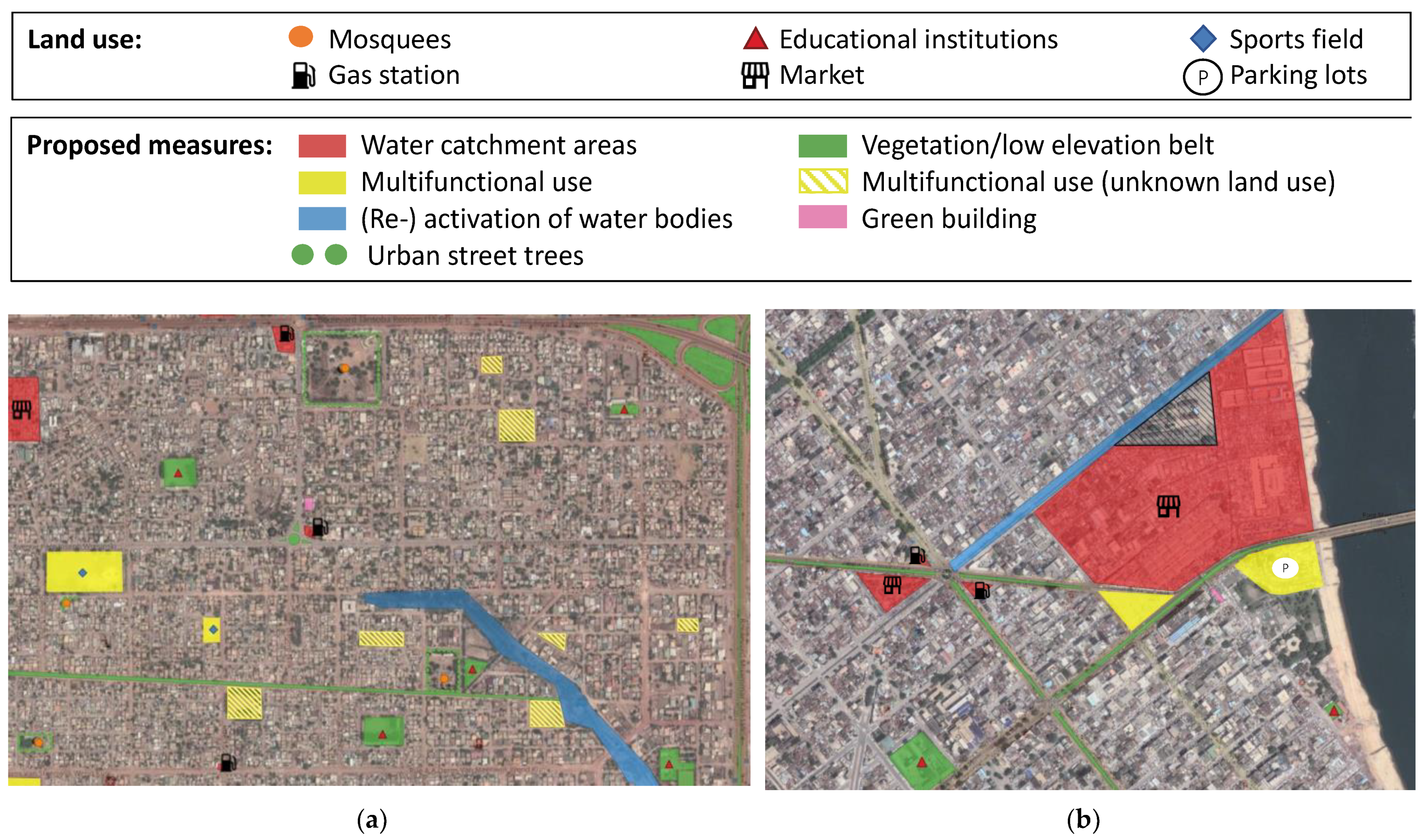
Figure 6 shows an overview of the proposed SPC implementations in the investigated city districts in Cotonou and Ouagadougou. Within this conceptualization, the individual SPC interventions are interconnected, ensuring symbiotic effects. For example, rainwater collected from roofs can be used to irrigate vegetation during dry periods. Additionally, low elevation belts with an appropriate gradient can act as waterways, allowing surface runoff to flow into multifunctional use areas or waterbodies during heavy rainfall events.
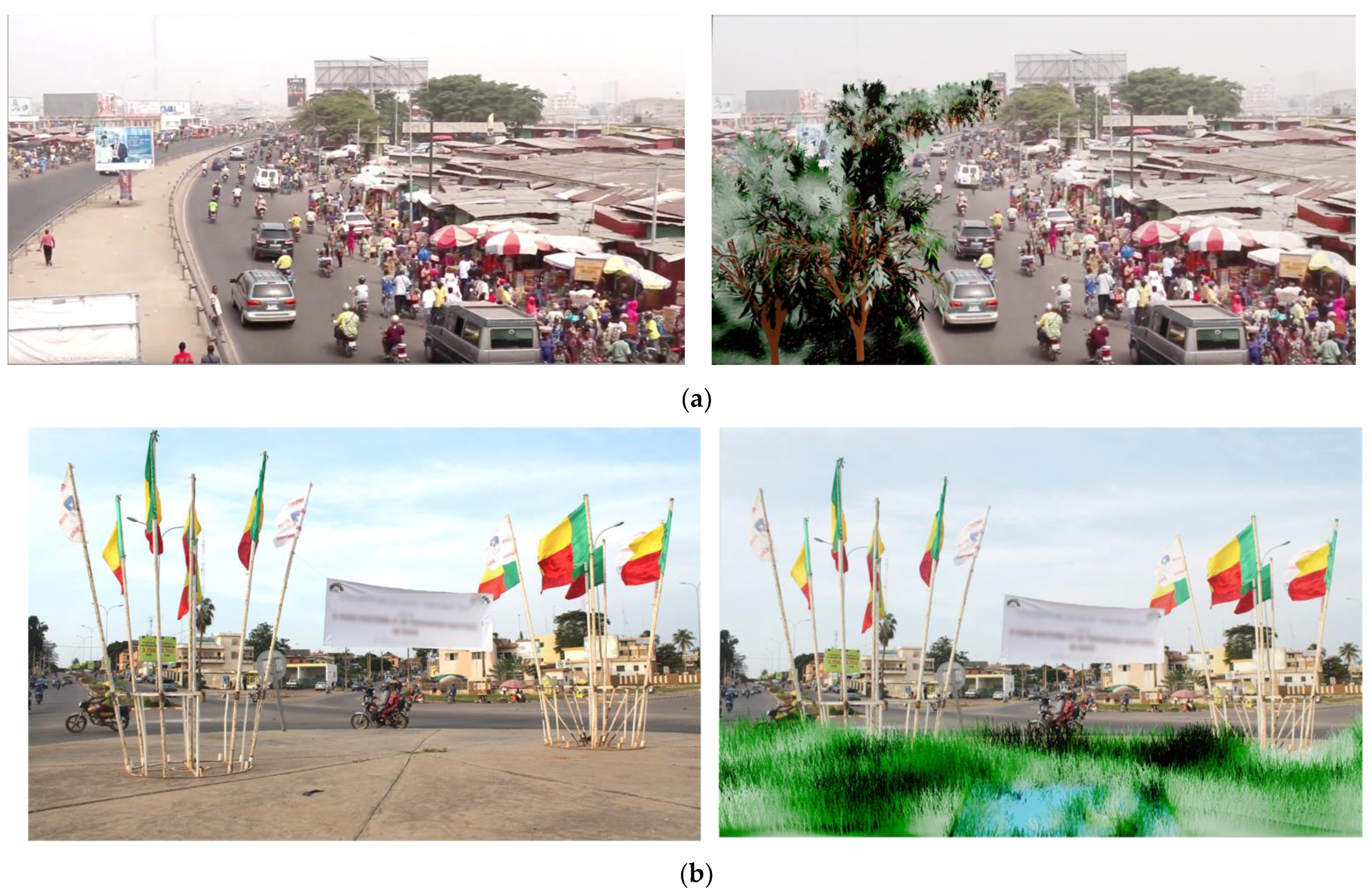
Green elements: To expand permeable surfaces and thereby increase the infiltration rate, local vegetation can be cultivated on free spaces and areas with low traffic. Along with this concept, unused road medians, roadsides, and car traffic circles are proposed for this intervention and are highlighted in Figure 6 and visualized in Figure 7. Additionally, low elevation green belts (LEGB) can be implemented to enhance the water retention capability. Experiments show that the infiltration quantity is approximately three- to four-times higher compared to the surrounding area due to the concave form of the vegetated surface [66]. The conventional paving structure of an LEGB consists of a cover layer, a planting soil layer, and sand and gravel layers at the bottom [67].
Additionally, the green dots in Figure 6 show public spaces where trees and vegetation can be planted. Locations along the edges of wide unpaved roads are proposed. It is in precisely such places that we will see how the combination of robust planting and irrigation with stored rainwater can ensure the preservation of the blue-green infrastructure during periods of drought. The characteristics of the local urban dynamics should be used for the selection of suitable sites, e.g., in arid regions like Ouagadougou, where some vegetation species need to be irrigated during dry periods. Urban street trees located near mosques can be benefited by the excess water resulting from Wudu. Wudu is a Muslim cleaning ritual during which parts of the body including hands and feeds are washed before prayer [68]. According to the forecasts made by the Pew Research Centre, 62.7% of Burkinabe will be Muslim by 2030, resulting in a high number of mosques [69]
Regarding the choice of vegetation, plants adapted to the local conditions must be considered. In Burkina Faso plant species such as Leptadenia pyrotechnica and Glacis and tree species such as Acaciaceae, Anacardiaceae, and Combretaceae exist [70]. According to the expert in Cotonou, trees such as mangroves, mango, and baobab can be found in southern Benin [28]. To ensure the efficient raising of seedlings, locally produced materials such as coconut coir can be considered. Originating from the coconuts’ waste, the coconut coir consists of dust and short fibres and is characterized by good water retention and aeration characteristics [71]. Furthermore, permeable pavements can be implemented in areas with less traffic such as the driveways of administration buildings (Figure 8).
The implementation of vegetation in inner courtyards, green roofs, and green facades at the household level is expected to be difficult to establish in Sub-Saharan African cities at this stage. Due to the demanding requirements such as high investment and maintenance costs, as well as structural and technical constraints, e.g., statics, slope, complete houses, and climatic extremes, these measures are largely dispensed with. Additionally, schoolyards can be used by implementing vegetation elements or founding urban gardening projects to profit from educational side-effects.
Temporal water storage: It is not favorable to ensure a high infiltration rate of rainwater in areas with large volumes of waste, due to the higher risk of groundwater pollution. Therefore, rainwater storage facilities can be installed. In the considered scope, the areas of markets and gas stations are assumed to be highly polluted. The upcoming rainwater at the highly frequented Dantokpa market, marked in red (Figure 6), can be collected from the roof surfaces. A quantitative example calculation serves to roughly estimate how much rainwater could be collected and made usable. Assuming a roof area portion of around 50% of the market area and a connection of half of the roof areas to a rainwater harvesting system, then around 3000 m3 of rainwater per hectare and year could be collected in Cotonou with an annual precipitation of 1208 l/m2. Afterwards the collected rainwater could be treated or used under controlled conditions including subsequent connection to the wastewater system for non-drinking purposes, e.g., by implementing public sanitation facilities. Additionally, simple devices, such as first flush systems that reduce the concentration of pollutants in the collected rainwater can be considered [72].
At the household level, rainwater can be harvested by catching up the runoff of the roof surface in a rainwater tank, assuming that the used roof material is hygienically harmless. To make the configuration of an SPC more attractive for private persons, the implementation and the maintenance can be integrated into a legal framework by ensuring tax support for private preventive measures against flooding or by giving subsidies for equipment (tanks, rain gutters, etc.). To retain large amounts of storm water during heavy rainfall events, the limited space in urban regions can be efficiently used by implementing multifunctional areas marked in yellow (Figure 6) Playgrounds and sport fields can be rebuilt, such as the “Waterplein” implemented in Rotterdam. Under dry conditions, the lower-lying place is made available for outdoor activities like basketball and skating. During rainfall events, the lower-lying impermeable areas are used as a temporarily retention for stormwater runoff from the neighboring catchment area and roof surfaces. Afterwards, the retained rainwater is discharged by a channel system [14]. In addition, open spaces with potential multifunctional use whose land use is unknown are marked with yellow stripes. Keeping in mind that many Sub-Saharan cities must face growing challenges related to water management (e.g., groundwater stress, lack of water supply), the collected rainwater can be filtered or treated and used afterwards. In order to avoid potential breeding grounds for waterborne diseases, appropriate technical facilities for the rapid drainage of rainwater must be ensured.
Furthermore, the rebuilding and exposure of canalized water sections and the reactivation of inactive water bodies, provide a controlled discharge of emerging rainwater runoff, as seen in Singapore. In the case of the Patte d’Oie district in Ouagadougou, the waterfront along the existing water body marked in blue (Figure 6) can be used as natural floodplains. The rainwater can be retained and infiltrated. Assuming that the water body is seasonally recharged during the rain period, the vegetation of adjacent areas can be intensified and implemented permanently in order to create an integrated city park. For a redesign towards a nature-based solution (e.g., wetlands, vegetation) of the existing concrete canal at the lagoon in Cotonou, different starting conditions such as the high level of groundwater, rainwater runoff coming from the neighboring market, and the limited space must be considered.

3.3. Step 3: Profit and Expenses of Implementing the SPC Concept

The lifetime performance of SPC offers multiple ecosystem services (e.g., environmental, ecological, and social) which cannot be evaluated appropriately [73]. Based on international experience, selected advantages and drawbacks associated with SPC implementation are compared.
The investment in SPC measures leads to financial risks in the private and public sectors [73]. With an estimated total of US$ 15–22 million for the initial costs of SPC per square kilometre in China, the prices can strongly vary [74]. Due to lack of experience, no specific information about the maintenance costs of green infrastructure elements in the considered urban areas are available [55]. However, besides the initial cost, future expenditures must be funded over the life cycle [73]. Depending on the selected plant species and geographical conditions, the use of vegetation can result in additional costs, e.g., poorly drained soil such as clay which needs to be additionally drained [73]. Furthermore, negative side effects could happen, such as uncontrolled tree root growth affecting the adjacent infrastructure [75]. On the other hand, new jobs in the public and private sectors could be created in the field of maintenance of green infrastructure [76]. It must be considered that personnel costs in Sub-Saharan Africa are generally low compared to European countries (e.g., monthly minimum wage—Benin: 61 € [77], Ethiopia [2019]: 19 € [78]).
In particular, the retention and use of rainwater in Sub-Saharan Africa represents an advantage of SPC that cannot be neglected. According to the World Water Development report made by the UN (2019), 24% of the population in Sub-Saharan Africa has access to safe drinking water; additionally, in 2015, 39 million people had to face the risk of groundwater drought [79,80]. To mitigate the negative effects of both extreme cases (droughts and flooding), rainwater harvesting based on the SPC appears to be a promising opportunity offering affordable water access and relieving the existing drainage systems during flooding events. In 2006, economic losses of $28.4 billion were estimated for the African continent. These losses were mainly caused by the lack of water and sanitation leading to productivity losses and additional costs in health treatment [81]. Currently, the specific price of water from the grid in Cotonou can vary between 174 and 695 FCFA/m3 (equivalent to 0.27–1.06 €/m3) depending on the supplier company, tranches, and intermediaries [28].
Flooding causes high economic losses on a national level. It is estimated that in Tanzania, the economic losses due to flooding are US$ 2 billion per year [82]. In such cases, flooding and its consequences can be mitigated by reducing the peak flow with the help of SPC implementation. Just to illustrate this, the positive effects of increased vegetation surfaces compared to impermeable surfaces in urban areas can be explained by the runoff coefficients of the standard ATV-DVWK-M 153 (vegetated surface: 0.05–0.1; asphalt: 0.9) [83].
Hussein (2008) estimates that water pollution and excessive water withdrawals in the Middle East and North Africa lead to economic losses of $ 9 billion per year, representing 2.1–7.4 percent of the GDP [84]. The implementation of SPC can lead to reduced pollution of stormwater runoff. According to Chan et al., suspended solids can be removed by permeable pavements (80–90%), bio swales (35–90%), and vegetation buffer (50–70%) [15]. In arid and coastal regions, vegetation stabilizes the soil and protects it from erosion by trapping its particles, mitigating the wind force near ground level, and covering the surface. The transport of soil across the roads can be reduced with trees and shrubs acting as a windbreaker [85,86]. Gaddis et al. points out that stormwater retention through interventions such as grass swales and infiltration basins is the most effective measure to reduce surface degradation in developed areas. Additionally, pollutants of stormwater runoff such as phosphorus can be reduced by 0.5% [7].
Furthermore, vegetation and trees lead to a cooling process thanks to evaporation and the generation of shadow. As a result, peak summer temperatures can be reduced by 1–5 °C [87,88]. Additionally, temperature differences of 11–25 °C between shaded and unshaded surfaces can be achieved [89]. According to the public assessment made by Gashu and Gebre-Egziabher (2019), temperature modification and air quality improvement are perceived as important benefits of green infrastructure by the inhabitants of Hawassa [32]. At least, green infrastructural elements provide several social benefits such as improvement of living environment, recreation, and the conservation of biodiversity [15].
Consequently, the profit level depends on the type and scale of the SPC measure. Probably, GI elements, primarily implemented at the surface require a lot of surface area to achieve a noticeable effect in case of extreme rainfall events. Therefore, financial and spatial resources for large-scale projects must be ensured. On the other hand, rainwater storage facilities appear as an efficient SPC tool, tackling two main challenges that many African cities must face: inadequate freshwater accessibility and bridging water failures as well as extreme weather conditions.

4. Discussion and Conclusions

Sponge City implementation can serve as a valuable and robust approach to tackle worldwide problems, especially those expressed by the sustainable development goals such as sustainable cities and communities (SDG 11), clean water and sanitation (SDG 6), industry, innovation, and infrastructure (SDG 9), good health and benefits (SDG 9) and no poverty (SDG 1) [90]. Worldwide, cities and their liveability play a decisive role in nations’ economic welfare. This can be measured by the percentage of the GDP that is contributed by urbanized and metropolitan areas. For example, in 2012, 40% of Rwanda’s GDP was contributed by only the capital Kigali [40]. Looking at the already obvious impacts of climate change, profound transformation of urban spaces is inevitable. This transformative effort will revolutionize the way water is drained, harvested, stored, and used in the city. But what is a realistic approach for sub-Saharan cities to initiate and drive this transformation under the conditions described?
In this article, several sub-Saharan sites were investigated in order to determine the extent to which sponge city implementation could succeed. It was elaborated that making Sub-Saharan African cities more resilient and liveable would give these countries a better chance to prosper economically and to strengthen their regional and global position. Well-developed rainwater harvesting systems can significantly increase urban water availability. Thus, further and stringent upgrade of decentralized rainwater harvesting solutions is a first and feasible option to tackle urban freshwater stress. However, circumstances such as financing, maintenance, a lack of legal framework, and claims of ownership, make the realization of a Sponge City program at the household level quite difficult, especially in informal settlements and slums. Particularly in the longer term, rainwater harvesting systems should be expanded to a more and more local but centralized level. To tap into this potential, a new and adapted way of dealing with precipitation in cities has to be implemented. This should be achieved in order to separately capture and manage the shares of unpolluted and low-polluted precipitation. It is precisely this “clean” rainwater that will then be a resource for a complementary urban water supply infrastructure. In this way, additional urban water needs could be met even in times of drought, while at the same time relieving the public drinking water supply. Drinking water should only be used when drinking-quality water is actually required. At the same time, this approach could help African cities implement a modern urban water system by bringing aboveground and underground water infrastructures into good synergy—as illustrated here by the example of operating only one sewer to drain away polluted water and keep clean (rainfall) water in the urban area.
However, major obstacles that must be overcome in African cities relate particularly to the financing and maintenance of SPC infrastructures and also to their social acceptance. Looking at the relatively high occurrence of water failures associated with power outages, water storage facilities at the household level provide an advantage in the daily life of individuals. Area-wide SPC interventions with open spaces (e.g., parks, multifunctional areas, reactivation of water bodies) are prone to solid waste accumulation and deforestation, because most of the cities considered are characterized by inadequate solid waste management. In order to avoid this unwanted use, the SPC measures need public acceptance and constant maintenance to achieve the positive effects for which they were planned. Social benefits including recreation and aesthetic appearance of the townscape can prevent unwanted use of these interventions. Additionally, public participation can lead to stronger identification of residents with the measures. An example of this, is the “citizens’ budget” practiced in Freetown, Sierra Leone, where 20% of the city’s tax revenue is used to fulfil residents’ wishes [91]. High building density in central districts, such as the city center of Cotonou, makes it difficult to implement extensive SPC interventions, therefore possible deconstruction measures of the hard grey infrastructure and the resulting costs must be accepted. Modernization projects such as the current reconstruction project of the Dantokpa market represent an opportunity to integrate the SPC concept. At this time it is not known whether GI elements or rainwater harvesting facilities are planned to be built [28].
Overall, further extensive research should be conducted during the planning process to determine land use, soil, and climate conditions. In particular, the financing of initial and (un)planned maintenance costs over the entire lifetime of SPC interventions must be ensured by decision-makers and financiers in advance. The creation of regulatory frameworks and subsidies by the government can lead to incentives for private investors. In addition to economic, political, and technical activities, sensitization programs such as urban gardening projects could be implemented to create awareness of the ecosystem services offered by a greener environment. To use local building materials, they must be available on site. In addition, their processing through local factories leads to a strengthening of the national economy. For SPC implementation, various stakeholders need to be involved: national and international donors, targeting the SDGs; urban and political authorities for legal and subsidy matters; non-governmental organizations acting as a link between the public and decision-makers; and sufficient experts knowing about SPC are needed for practical implementation.

Author Contributions

Conceptualization, A.T. and S.K.; methodology, A.T.; validation, S.K. and A.T.; investigation, A.T.; writing—original draft preparation, A.T. and S.K.; writing—review and editing, S.K. and A.T.; visualization, S.K. and A.T.; supervision, S.K. All authors have read and agreed to the published version of the manuscript.

Funding

The publication of this article was funded by the Open Access Fund of the Leibniz Universität Hannover.

Institutional Review Board Statement

Not applicable.

Informed Consent Statement

Not applicable.

Data Availability Statement

The data presented in this study are available on request from the corresponding author.

Acknowledgments

Special thanks to the experts who agreed to be interviewed and shared their knowledge and experience with us.

Conflicts of Interest

The authors declare no conflict of interest.

References and Notes

  1. Bundesministerium für wirtschaftliche Zusammenarbeit und Entwicklung. Städte Nachhaltig Gestalten; Bundesministerium für wirtschaftliche Zusammenarbeit und Entwicklung Bundesministerium für wirtschaftliche Zusammenarbeit und Entwicklung: Bonn, Germany, 2016. [Google Scholar]
  2. Eberhard, R. Access to Water and Sanitation in Sub-Saharan Africa, Part I—Synthesis Report; Deutsche Gesellschaft für Internationale Zusammenarbeit GmbH: Bonn, Germany, 2019. [Google Scholar]
  3. UN-Habitat. World Cities Report 2016: Urbanization and Development—Emerging Futures; UN-Habitat: Nairobi, Kenya, 2016; Available online: https://unhabitat.org/world-cities-report (accessed on 22 June 2021).
  4. Bundesministerium für Wirtschaftliche Zusammenarbeit und Entwicklung. Perspektiven der Urbanisierung—Städte Nachhaltig Gestalten; No. 03/2014; Bundesministerium für Wirtschaftliche Zusammenarbeit und Entwicklung: Bonn, Germany, 2014; p. 24. [Google Scholar]
  5. Kappelle, M. State of the Climate in Africa 2019; World Meteorological Organization: Geneva, Switzerland, 2020. [Google Scholar] [CrossRef]
  6. Nkonya, E.; Johnson, T.; Kwon, H.; Edward, K. Economics of Land Degradation in sub-Saharan Africa. In Economics of Land Degradation and Improvement—A Global Assessment for Sustainable Development; Nkonya, E., Mirzabaev, A., von Braun, J., Eds.; Springer: Cham, Switzerland, 2015. [Google Scholar]
  7. Gaddis, E.J.B.; Voinov, A.; Seppelt, R.; Rizzo, D.M. Spatial Optimization of Best Management Practices to Attain Water Quality Targets. Water Resour. Manag. 2014, 28, 1485–1499. [Google Scholar] [CrossRef]
  8. Todeschini, S.; Papiri, S.; Ciaponi, C. Placement Strategies and Cumulative Effects of Wet-weather Control Practices for Intermunicipal Sewerage Systems. Water Resour. Manag. 2018, 32, 2885–2900. [Google Scholar] [CrossRef]
  9. Brikké, F.; Vairavamoorthy, K. Managing Change to Implement Integrated Urban Water Management in African Cities. Aquat. Procedia 2016, 6, 3–14. Available online: https://cyberleninka.org/article/n/1417608 (accessed on 14 October 2021).
  10. Du Toit, M.J.; Cilliers, S.S.; Dallimer, M.; Goddard, M.; Guenat, S.; Cornelius, S.F. Urban green infrastructure and ecosystem services in sub-Saharan Africa. Landsc. Urban Plan. 2018, 180, 249–261. [Google Scholar] [CrossRef]
  11. Titz, A.; Chiotha, S.S. Pathways for Sustainable and Inclusive Cities in Southern and Eastern Africa through Urban Green Infrastructure? Sustainability 2019, 11, 2729. [Google Scholar] [CrossRef]
  12. Li, Z.; Xu, S.; Yao, L. A Systematic Literature Mining of Sponge City: Trends, Foci and Challenges Standing Ahead. Sustainability 2018, 10, 1182. [Google Scholar] [CrossRef]
  13. Sun, Y.; Deng, L.; Pan, S.Y.; Chiang, P.C.; Sable, S.S.; Shah, K.J. Integration of green and gray infrastructures for sponge city: Water and energy nexus. Water-Energy Nexus 2020, 3, 29–40. Available online: https://reader.elsevier.com/reader/sd/pii/S2588912520300151?token=EC10C3076B35AFAD24153BF7783FEC471DF7C3510E0185512CD9264345EF8E5D08307F6553C639B8F65E548882DD465B&originRegion=eu-west-1&originCreation=20220820204944 (accessed on 20 August 2022). [CrossRef]
  14. Kruse, E. Integriertes Regenwassermanagement für den Wassersensiblen Umbau von Städten. Großräumige Gestaltungsstrategien, Planungsinstrumente und Arbeitsschritte für die Qualifizierung Innerstädtischer Bestandsquartiere. Ph.D. Thesis, HafenCity Universität Hamburg, Hamburg, Germany, 2015. Available online: https://repos.hcu-hamburg.de/handle/hcu/423 (accessed on 8 October 2021).
  15. Chan, F.K.S.; Griffiths, J.A.; Higgitt, D.; Xu, S.; Zhu, F.; Tang, Y.-T.; Xu, Y.; Thorne, C.R. “Sponge City” in China—A breakthrough of planning and flood risk management in the urban context. Land Use Policy 2018, 76, 772–778. [Google Scholar] [CrossRef]
  16. Köster, S. Maintenance and Safety of Sponge City Infrastructure. In Urban Water Management for Future Cities: Technical and Institutional Aspects from Chinese and German Perspective; Köster, S., Reese, M., Zuo, J., Eds.; Springer International: Cham, Switzerland, 2019; pp. 13–55. [Google Scholar] [CrossRef]
  17. Jones, A.; Breuning-Madsen, H.; Brossard, M.; Dampha, A.; Deckers, J.; Dewitte, O.; Gallali, T.; Hallett, S.; Jones, R.; Kilasara, M. Soil Atlas of Africa; European Commission, Publications Office of the European Union: Luxembourg, 2013; Available online: https://data.europa.eu/doi/10.2788/52319 (accessed on 22 June 2021).
  18. Dos Santos, S.; Ouédraogo, F.D.C.; Soura, A.B. Water-related factors and childhood diarrhoea in African informal settlements. A cross-sectional study in Ouagadougou (Burkina Faso). J. Water Health 2014, 13, 562–574. [Google Scholar] [CrossRef] [Green Version]
  19. Merkel, A. Awassa Climate: Average Temperature, Weather by Month, Awassa Weather Averages—Climate-Data.org. 2021. Available online: https://en.climate-data.org/africa/ethiopia/southern-nations/awassa-5992/ (accessed on 28 July 2021).
  20. Merkel, A. Klima Kigali: Wetter, Klimatabelle & Klimadiagramm für Kigali. 2021. Available online: https://de.climate-data.org/afrika/ruanda/kigali/kigali-1044/ (accessed on 29 July 2021).
  21. Merkel, A. Klima Cotonou: Klimatabelle, Wetter & Wassertemperatur für Cotonou. 2021. Available online: https://de.climate-data.org/afrika/benin/littoral/cotonou-714874/ (accessed on 1 September 2021).
  22. Merkel, A. Klima Ouagadougou: Wetter, Klimatabelle & Klimadiagramm für Ouagadougou. 2021. Available online: https://de.climate-data.org/afrika/burkina-faso/mitte/ouagadougou-512/ (accessed on 2 September 2021).
  23. ‘Meteoblue.com: Simulierte historische Klima- und Wetterdaten für Beira’, Sep. 12, 2022. Available online: https://www.meteoblue.com/de/wetter/historyclimate/climatemodelled/beira_mosambik_1052373 (accessed on 2 September 2021).
  24. Africa Population 2022 (Demographics, Maps, Graphs). Available online: https://worldpopulationreview.com/continents/africa-population (accessed on 4 May 2022).
  25. Njeru, J. Interview, 18 June 2021. 2021.
  26. United Nations. World Urbanization Prospects—Population Division—United Nations. 2017. Available online: https://population.un.org/wup/ (accessed on 11 November 2021).
  27. Fournet, F.; Rican, S.; Vaillant, Z.; Roudot, A.; Meunier-Nikiema, A.; Kassié, D.; Dabiré, R.K.; Salem, G. The Influence of Urbanization Modes on the Spatial Circulation of Flaviviruses within Ouagadougou (Burkina Faso). Int. J. Environ. Res. Public Health 2016, 13, 1226. [Google Scholar] [CrossRef]
  28. Roos, G. Expertengespräch. 14 July 2021.
  29. Yamazaki, D.; Ikeshima, R.; Yamaguchi, T.; O’Loughlin, F. Topografische Karte Ouagadougou, Höhe, Relief. 2021. Topographic-map.com. Available online: https://de-de.topographic-map.com/maps/tlxo/Cotonou/ (accessed on 8 October 2021).
  30. Yamazaki, D.; Ikeshima, R.; Yamaguchi, T.; O’Loughlin, F. Topografische Karte Cotonou, Höhe, Relief. 2021. Topographic-map.com. Available online: https://de-de.topographic-map.com/maps/7n8e/Ouagadougou/ (accessed on 8 October 2021).
  31. MS Consultancy. Diagnostic Study for the Rehabilitation of Amora Gedel Constructed Wetland in Hawassa; MS Consultancy: Singapore, 2018. [Google Scholar]
  32. Gashu, K.; Gebre-Egziabher, T. Public assessment of green infrastructure benefits and associated influencing factors in two Ethiopian cities: Bahir Dar and Hawassa. BMC Ecol. 2019, 19, 16. [Google Scholar] [CrossRef] [PubMed]
  33. Zhang, X.Q.; Eichenauer, I.; Ryll, W. Financing for Resilient and Green Urban Solutions in Beira, Mozambique; UN Habitat: Nairobi, Kenya, 2020. [Google Scholar]
  34. Merkel, A. Beira Climate: Average Temperature, Weather by Month, Beira Water Temperature—Climate-Data.org. 2021. Available online: https://en.climate-data.org/africa/mozambique/sofala/beira-3189/ (accessed on 29 July 2021).
  35. Instituto Nacional de Estatística. Estatísticas Do Distrito, ‘Cidade Da Beira 2008’; Instituto Nacional de Estatística: Lisbon, Portugal, 2008.
  36. Doornewaard, R. Thirst? The Future Availability of Drinking Water in Beira, Mozambique. Master’s Thesis, Utrecht University, Utrecht, The Netherlands, 2015. [Google Scholar]
  37. Lackner, I. Drainage Rehabilitation Work for the Chiveve River in the Beira City Monitoring Report—Detailed Design Report- Solid Waste Disposal Concept for Goto Settlement; Inros Lackner: Bremen, Germany, 2014. [Google Scholar]
  38. Republic of Rwanda. Green Growth and Climate Resilience National Strategy for Climate Change and Low Carbon Development; National Strategy on Climate Change and Low Carbon Development: Kigali, Rwanda, 2011. [Google Scholar]
  39. World Bank. Rwanda—Overview. 2021. Available online: https://www.worldbank.org/en/country/rwanda/overview (accessed on 29 July 2021).
  40. Baffoe, G.; Ahmad, S.; Bhandari, R. The road to sustainable Kigali: A contextualized analysis of the challenges. Cities 2020, 105, 102838. [Google Scholar] [CrossRef]
  41. Desa, U.N. Population Division, Department of Economic and Social Affairs, United Nations Secretariat. In World Urbanization Prospects, the 2011 Revision; United Nations Publications: New York, NY, USA, 2014. [Google Scholar]
  42. Florczyk, A.; Corban, C.; Schiavina, M.; Pesaresi, M. GHS Urban Centre Database 2015, Multitemporal and Mulitdimensional Attrubutes, R2019A; Joint Research Centre European Commission: Luxembourg, 2019. [Google Scholar]
  43. Nikuze, A.; Sliuzas, R.; Flacke, J.; van Maarseveen, M. Livelihood impacts of displacement and resettlement on informal households—A case study from Kigali, Rwanda. Habitat Int. 2019, 86, 38–47. [Google Scholar] [CrossRef]
  44. Asumadu-Sarkodie, S.; Rufangura, P.; Jayaweera, M.P.C.; Owusu, P.A. Situational Analysis of Flood and Drought in Rwanda’, Herath Jayaweera, Middle East Technical University. 2016. Available online: https://www.researchgate.net/publication/309191249_Situational_Analysis_of_Flood_and_Drought_in_Rwanda (accessed on 29 July 2021).
  45. Maliki, R. Etude Hydrologique du Littoral Béninois Dans la Région de Cotonou (Afrique de l’Ouest). Ph.D. Thesis, Université Cheick Anta Diop, Dakar, Sénégal, 1993. [Google Scholar]
  46. Hounkpe, S.P.; Adjovi, E.C.; Crapper, M.; Awuah, E. Wastewater Management in Third World Cities: Case Study of Cotonou, Benin. J. Environ. Prot. 2014, 5, 387–399. [Google Scholar] [CrossRef]
  47. World Bank. Benin: World Bank Provides $100 Million to Reduce Flood Risks and Strengthen Urban Resilience in the Capital City Cotonou. 2019. Available online: https://www.worldbank.org/en/news/press-release/2019/05/23/benin-world-bank-provides-100-million-to-reduce-flood-risks-and-strengthen-urban-resilience-in-the-capital-city-cotonou (accessed on 31 August 2021).
  48. ASCECNA. Données Pluviométriques de Cotonou: Station de l’Aéroport de Cotonou; ASCECNA: Dakar, Senegal, 2008.
  49. Amoussou, E.; Totin, H.; Odoulami, L.; Edorh, P. Groundwater pollution and the safe water supply challenge in Cotonou town, Benin (West Africa). In Proceedings of the H04, IAHS-IAPSO-IASPEI Assembly, Gothenburg, Sweden, July 2013. [Google Scholar] [CrossRef]
  50. Sare, B.; Sina, H.; Soumanou, S.; Tente, B.; Baba-Moussa, L.; Houssou, C. Solid Waste Management Strategies at The Port of Cotonou (Benin, West Africa). Int. J. Dev. Res. 2017, 7, 1395313958. [Google Scholar]
  51. Raveloarison, M. Expertengespräch. 5 July 2021.
  52. Boyer, F.; Delaunay, D. Peuplement de Ouagadougou et Développement Urbain: Rapport Provisoire. Ph.D. Thesis, Institut de Recherche pour le Développement, Marseille, France, January 2009. [Google Scholar]
  53. Macrotrends. Ouagadougou, Burkina Faso Metro Area Population 1950–2021. 2021. Available online: https://www.macrotrends.net/cities/23192/ouagadougou/population (accessed on 2 September 2021).
  54. INSD & ICF International. Enquête Démographique et de Santé et à Indicateurs Multiples du Burkina Faso 2010; Institut National de la Statistique et de la Démographie, ICF International: Calverton, MD, USA, 2012. [Google Scholar]
  55. Singh, R.; Bwalya, D.; Fu, D. Feasibility and Adaptability of Sponge City Concept: A Case Study of Lusaka, Zambia. 2018. Available online: https://www.researchgate.net/publication/325796820_Feasibility_and_Adaptability_of_Sponge_City_Concept_a_Case_Study_of_Lusaka_Zambia (accessed on 2 September 2021).
  56. Bolay, J.-C. Urban Facts. In Urban Planning Against Poverty: How to Think and Do Better Cities in the Global South; Bolay, J.-C., Ed.; Springer International: Cham, Switzerland, 2020; pp. 7–55. [Google Scholar] [CrossRef]
  57. Abbott, J. Green Infrastructure for Sustainable Urban Development in Africa; Routledge: London, UK, 2012. [Google Scholar] [CrossRef]
  58. Jiménez, B.; Drechsel, P.; Koné, D.; Bahri, A.; Raschid-Sally, L.; Qadir, M. Wastewater, Sludge and Excreta Use in Developing Countries: An Overview. 2010, pp. 3–27. Available online: https://www.dora.lib4ri.ch/eawag/islandora/object/eawag%3A23195/ (accessed on 15 October 2021).
  59. Bolay, J.-C. Global Sustainability: How to Rethink Urban Planning. In Urban Planning Against Poverty: How to Think and Do Better Cities in the Global South; Bolay, J.-C., Ed.; Springer International: Cham, Switzerland, 2020; pp. 57–82. [Google Scholar] [CrossRef]
  60. Hunter, P.R. Climate change and waterborne and vector-borne disease: Climate Change and Disease. J. Appl. Microbiol. 2003, 94, 37–46. [Google Scholar] [CrossRef]
  61. Khyade, V.B.; Tyagi, B.K. Control of Vector Borne Diseases Through Microbial Paratransgenesis. Biology 2017, 4, 10. [Google Scholar]
  62. Müller, R.; Reuss, F.; Kendrovski, V.; Montag, D. Vector-Borne Diseases. In Biodiversity and Health in the Face of Climate Change; Marselle, M., Stadler, J., Korn, H., Irvine, K., Bonn, A., Eds.; Springer International: Cham, Switzerland, 2019; pp. 67–90. [Google Scholar] [CrossRef]
  63. Ember, C.R.; Ember, M. Encyclopedia of Medical Anthropology: Health and Illness in the World’s Cultures Topics—Volume 1; Cultures; Springer Science & Business Media: Berlin/Heidelberg, Germany, 2003. [Google Scholar]
  64. Yin, D.; Chen, Y.; Jia, H.; Wang, Q.; Chen, Z.; Xu, C.; Li, Q.; Wang, W.; Yang, Y.; Fu, G.; et al. Sponge city practice in China: A review of construction, assessment, operational and maintenance. J. Clean. Prod. 2021, 280, 124963. [Google Scholar] [CrossRef]
  65. Rave, H. Expert Interview. 18 May 2021.
  66. Tingting, L.; Chunlan, D.; Bo, L.; Yi, L. Rainwater utilization of green streets in the sustainable city. In Proceedings of the 29th IASTEM International Conference, Osaka, Japan, 7 August 2016; Volume 3, p. 5. [Google Scholar]
  67. Jiang, L.; Yin, C.; Qin, B. Low Elevation Greenbelt Paving Structure Based on Sponge City Ideas. CN106034818A, 26 October 2016. Available online: https://patents.google.com/patent/CN106034818A/en (accessed on 8 October 2021).
  68. Lexikon der Religionen. Wudu. 2020. Available online: https://religion.orf.at/lexikon/stories/3200359/ (accessed on 8 October 2021).
  69. Pew Research Center’s Religion & Public Life Project. Religious Composition by Country, 2010–2050. 2015. Available online: https://www.pewforum.org/2015/04/02/religious-projection-table/ (accessed on 1 October 2021).
  70. Schmidt, M. Pflanzenvielfalt in Burkina Faso: Analyse, Modellierung und Dokumentation. 2006. Available online: http://publikationen.ub.uni-frankfurt.de/frontdoor/index/index/docId/2202 (accessed on 8 October 2021).
  71. Xiong, J.; Tian, Y.; Wang, J.; Liu, W.; Chen, Q. Comparison of Coconut Coir, Rockwool, and Peat Cultivations for Tomato Production: Nutrient Balance, Plant Growth and Fruit Quality. Front. Plant Sci. 2017, 8, 1327. [Google Scholar] [CrossRef]
  72. Tankshop. 100mm Downpipe First Flush Water Diverter (Rain Harvesting)—WDDP02. 2021. Available online: https://www.tankshop.com.au/rain-harvesting-accessories/first-flush-water-diverters/rain-harvesting-100mm-downpipe-first-flush-water-diverter/ (accessed on 8 October 2021).
  73. Li, H.; Ding, L.; Ren, M.; Li, C.; Wang, H. Sponge City Construction in China: A Survey of the Challenges and Opportunities. Water 2017, 9, 594. [Google Scholar] [CrossRef]
  74. Liang, X. Integrated Economic and Financial Analysis of China’s Sponge City Program for Water-resilient Urban Development. Sustainability 2018, 10, 669. [Google Scholar] [CrossRef]
  75. Balder, H.; Ehlebracht, K.; Mahler, E. Strassenbäume: Planen—Pflanzen —Pflegen am Beispiel Berlin; Patzer: Berlin, Germany, 1997. [Google Scholar]
  76. King, A.; Shackleton, C. Maintenance of public and private urban green infrastructure provides significant employment in Eastern Cape towns, South Africa. Urban For. Urban Green. 2020, 54, 126740. [Google Scholar] [CrossRef]
  77. Federal Minimum Wage. Benin Minimum Wage—World Minimum Wage Rates 2021. 2021. Available online: https://www.minimum-wage.org/international/benin (accessed on 29 September 2021).
  78. Wagelindicator Foundation. Minimum Wages Regulations—Ethiopia. 2019. Available online: https://wageindicator.org/labour-laws/labour-law-around-the-world/minimum-wages-regulations/minimum-wages-regulations-ethiopia (accessed on 29 September 2021).
  79. UN-Water. UN World Water Development Report 2019: “Leaving No One Behind”. 2019. Available online: https://www.unwater.org/world-water-development-report-2019-leaving-no-one-behind/ (accessed on 16 October 2021).
  80. Villholth, K. Groundwater drought risk in sub-Sahara Africa. 2015. Water Land and Ecosystems Web site. Available online: https://wle.cgiar.org/groundwater-drought-risk-sub-sahara-africa (accessed on 16 October 2021).
  81. WHO. Economic and Health Effects of Increasing Coverage of Low Cost Household Drinking-Water Supply and Sanitation Interventions to Countries Off-Track to Meet MDG Target 10: Background Document to the “Human Development Report 2006”; WHO/SDE/WSH/07.05; 2007. Available online: https://apps.who.int/iris/handle/10665/69684 (accessed on 16 October 2021).
  82. Adekola, O. Many African Countries Are Flooding, Risking Decades of Development if They Do Not Adapt. 2018. Available online: http://theconversation.com/many-african-countries-are-flooding-risking-decades-of-development-if-they-do-not-adapt-106581 (accessed on 16 October 2021).
  83. DWA. DWA-M 153—Empfehlung Regenwasser (08/2007). 2007. Available online: https://webshop.dwa.de/de/merkblatt-dwa-m-153-august-2007.html (accessed on 16 October 2021).
  84. Hussein, A.M. Costs of environmental degradation: An analysis in the Middle East and North Africa region. Manag. Environ. Qual. Int. J. 2008, 19, 305–317. [Google Scholar] [CrossRef]
  85. Van de Ven, T.A.M.; Fryrear, D.W.; Spaan, W.P. Vegetation characteristics and soil loss by wind. J. Soil Water Conserv. 1989, 44, 347–349. [Google Scholar]
  86. Wolfe, S.; Nickling, W.G. The protective role of sparse vegetation in wind erosion. Prog. Phys. Geogr. Earth Environ. 1993, 17, 50–68. [Google Scholar] [CrossRef]
  87. Huang, Y.J.; Akbari, H.; Taha, H. The wind-shielding and shading effects of trees on residential heating and cooling requirements. ASHRAE Proc. 1990, 96 Pt 1. Available online: https://escholarship.org/uc/item/85g3s8xt (accessed on 23 October 2021).
  88. Kurn, D.M.; Bretz, S.E.; Huang, B.; Akbari, H. The Potential for Reducing Urban Air Temperatures and Energy Consumption through Vegetative Cooling; LBL-35320; Lawrence Berkeley Lab: Berkeley, CA, USA, 1994. [CrossRef]
  89. Akbari, H.; Kurn, D.M.; Bretz, S.E.; Hanford, J.W. Peak power and cooling energy savings of shade trees. Energy Build. 1997, 25, 139–148. [Google Scholar] [CrossRef] [Green Version]
  90. UN. The 17 Goals Sustainable Development. 2021. Available online: https://sdgs.un.org/goals (accessed on 18 November 2021).
  91. Aki-Sawyerr, Y. Urbanisierung in Afrika—Die Zukunft Liegt in Den Städten! Africa Business Network: Berlin, Germany, 2021. [Google Scholar]
Figure 1. Procedure and type of data used to analyse the potential of SPC in Sub-Saharan Africa.
Sustainability 14 11726 g001
Figure 2. Location of the chosen pilot cities in Sub-Saharan Africa: Ouagadougou (Sahel zone), Cotonou (West Africa), Hawassa (East Africa), Kigali (Central Africa), Beira (Southeast Africa), (source (map): Wikimedia.
Sustainability 14 11726 g002
Figure 3. Selection of interventions aspiring the idea of SPC, classified by strategy and user type (collected measures according to: [15,16]).
Sustainability 14 11726 g003
Figure 4. Topographical map of the studied districts: (a) Patte d’Oie, Ouagadougou [29], (b) Dantokpa Market, Cotonou [30] (according to creative commons license CC BY-NC 4.0 https://creativecommons.org/licenses/by-nc/4.0/, accessed on 8 October 2021).
Sustainability 14 11726 g004
Figure 5. Rethinking of planning: sidewalks in parts of Africa are not only used for traffic but also for vending, informal business, and as a meeting point; Benin, 2014 (own photo).
Sustainability 14 11726 g005
Figure 6. Land use and the proposed measures according to the SPC concept, classified by the type of intervention in the two areas of investigation: (a) the Patte d’Oie district in Ouagadougou, (b) Dantokpa Market in Cotonou.
Sustainability 14 11726 g006
Figure 7. Before and after, green elements to increase the rates of infiltration and evaporation: (a) vegetated road median, (b) vegetation at unused urban areas such as road circles, Cotonou 2014.
Sustainability 14 11726 g007
Figure 8. Driveways at public service buildings with permeable pavements, Cotonou 2014.
Sustainability 14 11726 g008
Table 1. Overview of chosen key data of the selected pilot cities: climate zone [17,18]; annual precipitation [mm/a] [19,20,21,22,23]; topography and expected and existent challenges due to climate change, estimated; number of inhabitants in 2022 [18,24]; and urban growth rate in 2017 [25,26].
Location of
Operation
Ethiopia
Hawassa
Mozambique
Beira
Rwanda
Kigali
Benin
Cotonou
Burkina Faso
Ouagadougou
Climatic zone[-]Tropical
monsoon
Tropical wet dry
savannah
TemperateTropicalTropical savannah
Precipitation[mm/a]112416099911208569
Topography[-]Valley, surrounding mountainsFlat, coastlineHillyFlat, coastlineTropical savannah
Main challenges[-]FloodingFlooding, Cyclones, sea-level riseFlooding, droughtFloodingFlooding, drought
Inhabitants[-]250,000602,0601,208,296708,9993,055,788
Urban growth rate[-]n/a2.653.341.004.86
Table 2. Overview of the identified considerations being taken into account in the conceptualization of SPC elements.
Considerations
GeographyTopography
Climate
Soil compositions
Vegetation
SocioeconomicsUrban dynamics
Existing infrastructure
Space-saving measures and public acceptance
Local materials
Reduce of health risks
Low costs
Simplicity
Publisher’s Note: MDPI stays neutral with regard to jurisdictional claims in published maps and institutional affiliations.