Abstract
Assessing water resources at a large river basin scale is important for having an idea of the water situation and efficient water resources management. What is the most appropriate approach to assess the water resources at a large river basin scale? This paper aims to develop a systematic review on water resources assessment at a large river basin scale, intending to present a new assessment method for the major river basins in Madagascar. This review investigates 40 articles from Google Scholar, Web of Science, and PubMed databases, from 2000 to 2022. This review has demonstrated the necessity of water resources assessment at a large river basin scale in Madagascar. An improvement in the use of multiple GCMs and SWAT models for water resources assessment within the basin was found necessary for appropriate water allocating regimes among upper and lower reaches. Water allocation and water scarcity at the basin level could be addressed by using the inter- and intra-basin approaches. The review concludes that a combination of the SWAT, multiple GCMs, and inter- and intra-basin approaches could be efficiently applied for assessing the water resources at a large basin scale. This review may be of benefit to scientists and water specialists.
1. Introduction
Basin-scale water scarcity is alarming in many countries worldwide [1,2,3,4,5,6,7,8,9]. It is an increasing concern related to the global climate predictions and possible environmental impacts on freshwater worldwide. Freshwater is the total amount of a country’s natural renewable water resources, in terms of both surface and groundwater. However, not all natural freshwater is accessible for use. Scarcity and disparity in water resources are exacerbated by the impact of human activity and climate change, which disrupts the water regimes and leads to a deterioration in water quality [3]. The increase in population and water demand has put pressure on water resources in various parts of the globe [10]. It has been reported that nearly 6 billion people will suffer from clean water scarcity by 2050 [11]. A previous study revealed that water scarcity was threatening two-thirds of the African population in the sub-Saharan region, one-quarter of which is undernourished, and one-fifth face serious water shortages [12]. Rakotoarimanana and Ishidaira (2022) found that climate change will reduce water availability in Madagascar’s major river basins by 2040 [13]. Moreover, it has been found that water-related natural hazards are the most destructive to human life and property [14,15,16]. Therefore, those studies are significant because they show how urgent effective water resource assessment and management are. Water resource assessment is the determination of the sources, extent, dependability, and quality of water resources for their utilization and control [17]. It particularly focuses on issues relating to the availability and accessibility of, and demand for, both water resources and water supply services [18]. A large and growing body of literature has assessed the water resources available globally, in a specific country or region. National-level data do not show the local diversity, especially in large countries, so it would be preferable to examine each watershed or river basin scale to have an idea of the water situation [3]. A previous study stated the increasing challenges in the management at the river-basin scale in developing countries due to diverse factors such as socio-economic issues, stakeholder perspectives, and the use of water for various purposes [19]. However, many researchers have demonstrated the necessity of assessing the water resources to provide sustainable solutions for water-related problems, and a comprehensive understanding of the quality and quantity of water resources in their study area [6,20,21]. Assessing water resources can also help to clarify the current status of water resource availability and use, as well as solve conflicts and improve the efficacity of water-related policies [22,23]. Water resources assessment is being increasingly promoted as a key component of Integrated Water Resources Management (IWRM) [24]. It is important for the efficient management of water resources and the river basins, particularly on a large scale.
Researchers have used various methods to assess water resources, such as the long-term water balance method, Geographic Information Systems (GIS), and hydrologic and hydraulic models. Some studies coupled different methods to develop a water balance model. The hydraulic–hydrologic modeling approach, for example, improves the understanding of water movement, and the prediction and assessment of future impacts [25,26]. The quantity of water generated from the watershed or river basin can be represented by hydrologic modeling, while hydraulic modeling can deal with the physical properties of water (depth of flow in a pipe or open channel). Previous studies have reported that interfacing between these models and GIS may be a very efficient way of overcoming difficulties and getting excellent results in terms of engineering practice [27,28]. GIS technology can represent water resource systems in the real world with a consideration of spatial dimensions, including the geography and topology of the river basin. McKinney, et al. (1999) concluded that the future direction for modeling will lie in GIS-based decision support systems that integrate economic, agronomic, institutional, and hydrologic components [29]. However, Xu and Singh (2004) reported that there is not yet much intrinsic water quality modeling being done within GIS [30]. Their studies have demonstrated the problem of parameter estimation as the greatest obstacle to the successful application of water resource assessment models. Along with these current advances in hydrologic and hydraulic models, however, there are still significant modeling challenges to overcome [31,32]. This indicates a need to evaluate the recent methods that have already been developed to assess water resources.
A large and growing body of literature concerns the systematic review of water resources assessment at a large river basin scale in a whole country [33,34,35,36]. However, no previous study has investigated the case of Madagascar. The following literature review aims to develop a systematic review of water resources assessment at the large river basin scale. In particular, this research seeks to examine the appropriate method for assessing the water resources across the major river basins in Madagascar. This paper will provide an overview of the current advances and challenges in the large river basin-scale assessment of water resources. It has been demonstrated that the sustainability of future economic growth and environmental health depends on the allocation of water resources in river basins [29]. Therefore, we intend to present a new method that could efficiently allocate the water within a basin and is able to overcome water scarcity. This paper begins by explaining the necessity of water resource assessment at a large river basin scale in Madagascar. Then, it presents the current approaches for water resource assessment in large river basins worldwide. The next section of this paper describes the new model suggested for river basins in Madagascar. Finally, the conclusion gives a brief summary of the findings and their significance.
2. Materials and Methods
A systematic review of the existing literature on the water resources assessment at a large river basin scale is conducted to gain a comprehensive understanding and to evaluate the progress of different approaches used in solving today’s global water crisis. There are different methods of conducting a systematic literature review. Khan et al. (2003), for example, proposed five steps as follows: (1) framing questions for a review, (2) identifying relevant work, (3) assessing the quality of studies, (4) summarizing the evidence, and (5) interpreting the findings [37]. Yu Xiao and Maria Watson (2019) suggested eight steps to improve accuracy in literature reviews [38]. Both methods have similarities, as they highlight how important the definition of the problem and the quality of the studies are. This systematic review was processed based on the steps provided in both methods. Figure 1 represents the conceptual design of the systematic research.
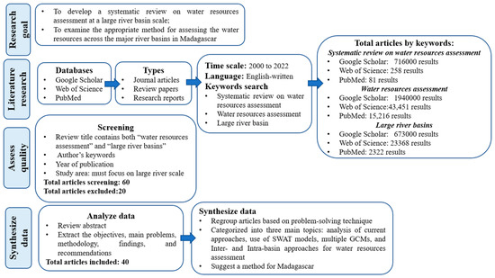
Figure 1.
Flow diagram of systematic review process.
English-language original journal articles, review papers, and research reports from Google Scholar, Web of Science, and PubMed from 2000 to 2022 were obtained. This research mainly focused on water resources assessment at a large basin scale. First, three online databases using the keywords “systematic review on water resources”, “water resources assessment”, and “large river basin” were researched. Then, all the relevant information of the reviews, such as the title, author, year of publication, and the abstract, was obtained for further evaluation. The relevance of each manuscript was determined via the author’s keywords, the problem-solving technique, and the study area (which had to focus on a large river scale). Articles that did not meet any of these criteria were excluded. In total, 40 articles were investigated in this study. Finally, all the articles were analyzed and categorized into three main topics:
- Current approaches for water resources assessment in a large river basin;
- Use of Soil and Water Assessment Tool (SWAT) models and multiple General Circulation Models (GCMs) for water resources assessment;
- Application of inter- and intra-basin approaches to water resources assessment.
3. Results and Discussion
3.1. Necessity of Water Resources Assessment at a Large River Basin Scale in Madagascar
Madagascar has potential freshwater availability but is currently vulnerable to water scarcity. Most of the studies conducted in Madagascar have focused on the small basin and catchment scales [39,40,41]. However, some researchers have started to investigate on a large basin scale recently. Artificial Neural Networks (ANN) and SWAT models have been reported to perform better in assessing the future impact of climate change on the hydrology in the Mangoky river basin for the periods of the 2040s and 2090s [42]. A study on the Tsiribihina basin highlighted the benefit of the use of satellite altimeters with the Modelo de Grandes Bacias models in monitoring the past and present discharges and water depth time series [43]. The use of the Spatial Tools for River basins, Environment and Analysis of Management (STREAM) model demonstrated the linkages between climate variability, hydrology, forest cover, population growth, and the adjacent coral reefs in the Onilahy basin for the period 1950 to 2006 [44]. The results of these studies have demonstrated the performance of the hydrological model in assessing water resources at a large basin scale. Importantly, little research so far has examined the direct relationship between the changes in hydrology and the demographic and future impacts of climate change at a large river basin scale and over long periods in Madagascar. Furthermore, no study has investigated all twelve major river basins in Madagascar (Figure 2), which would be fundamental to a better monitoring and understanding of the hydrological processes across the country.
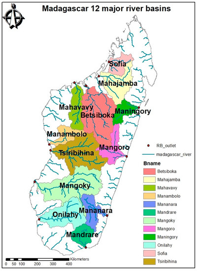
Figure 2.
Map of the 12 major river basins in Madagascar.
The conceptual framework presented in Figure 3 highlights the link between climate change, land use land cover change, population growth impact, and river basin management in Madagascar. Therefore, a complete understanding of all variables and their interrelationship over time is needed to allocate the water and better manage the basins. Climate change, land use and land cover change, population growth, and the established policy have a great impact on water resources, and on the lives and livelihoods of communities living in and around the major river basins. So, the non-consideration of these variables has induced the degradation of river environments, giving rise to water resource issues in terms of their quantity and quality. Although Madagascar is not yet on the list of countries with tensions or even wars related to water resources [1,45], the approach used should allow for the sustainability of the quantities used and the potentialities of water resources. Water resource assessments and the awareness of climate change will hopefully contribute to the Integrated Water Resources Management (IWRM) implementation in the major river basins in Madagascar.
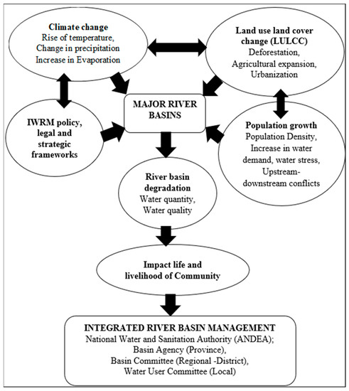
Figure 3.
Conceptual framework for the Integrated Water Resources Management (IWRM) as implemented in the major river basins in Madagascar.
3.2. Current Approaches for Water Resources Assessment at a Large River Basin
The first key area of this review concerns the approach used for water resources assessment at a large river basin scale. Several programs have been designed to assess the water resources development and management policies at the river basin scale.
The first method is the long-term water balance method, a traditional means of assessing the water resources at the watershed or basin scale. The surface water balance processes include precipitation infiltration, overland runoff, evapotranspiration, and canopy surface interception losses, while the subsurface process considers soil moisture. A previous study demonstrated that this method was useful, but has several disadvantages, because it is unable to simulate and estimate the water resources [30]. This method would be more useful if it could predict the future situation of the water resources, which is crucial for water and land use planning, decision-making, and water resources management. The efficient performance of the new generation of distributed models compared to the traditional long-term water balance methods in regional- and large-scale assessments of water resources was reported by Xu and Singh (2004) [30].
The second method consists of conceptual hydraulic and hydrologic models, which play a vital role in the analysis of water resources and also in achieving sustainable development [46,47,48]. The statistical downscaling of future climate scenarios and a water balance model in a hydrological modeling framework were employed to assess the impacts of climate change on water availability in Zambia. Climate change will worsen the water stress in Zambia, and there will be significant differences at the river basin level [49]. Under limited data conditions, the potential of the WetSpass-M model was demonstrated for assessing the spatial and temporal distributions of groundwater recharge (GWR) in Ethiopia [50]. The PATRICAL model, a monthly conceptual distributed water balance model that includes the surface water (SW) and groundwater (GW) behavior, and the river–aquifer interaction, was proven to be less complex and robust, and required fewer data for water resource assessments in a medium–large river basin in Spain [51]. The Xin’anjiang (XAJ) model, GR4J model, SIMHYD model, and RCCC-WBM model performed efficiently in runoff simulation in all six subcatchments in the Yellow River basin, China [52]. It was revealed that the XAJ model was effective in terms of the Nash–Sutcliffe efficiency coefficient, while the RCCC-WBM model is recommended for water resource assessment under changing environmental conditions in semi-arid regions. Another study applied a semi-distributed rainfall–runoff GW-PITMAN model in the Congo River [53]. It was found that the basin was able to capture the timing and magnitude of high and low flows satisfactorily, irrespective of whether the subbasins were located in headwater areas, downstream areas, or at the outlets of regions strongly affected by wetlands and lakes. These studies are important because they show the accuracy of the precipitation data and topographic factors in improving runoff and controlling water resource estimation. Unmanned aerial vehicle systems (UAVs) have been widely applied in water resources monitoring and assessment (mapping and modeling the water quality and quantity) in the Global South, but the lack of reliable water data and research focusing on UAV application has remained a challenge [54]. A question that needs to be asked, however, regards the possibility of the application of UAVs in Madagascar, regarding the high operational costs, drone procurement regulations, and lack of relevant skills. The water resources of China’s Transboundary River Basin were assessed using the Machine Learning Approach [55], and this found a consistency in the results with the AQUASTAT database at the country level (root–mean–square error = 76.97 km3/year, normalized root–mean–square error = 12%). These results show that the accuracy of a hydrological model simulation depends mainly on the precipitation accuracy, and several hydrologic models are now available for researchers. A Dynamic Systems Approach was used in several studies to develop systems dynamic and simulation models, and to assess the water resources’ sustainability in various river basins globally. To illustrate this, 50-year simulations using a Water Resources Model for the Piracicaba, Capivari, and Jundiaí River Basin (WRM-PCJ) in Brasil were conducted by Sánchez-román, R.M., et al., 2010 [56]. The WRM-PCJ model performed efficiently and proved to be an excellent tool for decision and policymakers. Similarly, the Volta River Basin System Dynamics (VRB-SD) was developed to examine the feedback processes and interactions between the population, the water resource, and the agricultural production subsectors of the Volta River Basin in Ghana [57]. It was found that the model improved stakeholders’ understanding of the dynamic behavior of the VRB over time. An agent-based model (ABM) was applied for farmers’ decision-making over water use, under the influence of water management policies and a distributed hydrological model (GSFLOW) for simulating integrated groundwater–surface water processes in China with high spatial and temporal resolutions [58]. They found the key factors influencing human–hydrological interactions through regional hydrogeological conditions, such as depth to the water table and distance to rivers. Those studies showed how the Dynamic Systems Approach can help stakeholders and policymakers in river basin management. There has been an increasing amount of literature on the use of SWAT models [59,60], multiple GCMs [61,62,63], and inter- and intra-basin approaches [5,64,65]. The SWAT model is widely used in water resources assessment studies [66,67,68,69]. The use of multiple GCMs generates more robust scenarios and reduces uncertainty in projecting future climate data [70,71]. The inter- and intra-basin approaches present a water allocation strategy within a basin and among basins [5,64]. Further analysis of the applicability of these methods to water resource assessment at the large river basin scale will be discussed below.
3.3. Use of Multiple GCMs and SWAT Models for Water Resources Assessment
In this section, an overview of the use of multiple GCMs and SWAT models for water resources assessment at a large basin scale is presented.
The GCMs have been widely used to drive hydrologic models for predicting the changes in river runoff on a basin scale under various climate projections [72]. Two approaches are used to handle the climate data of GCMs: a single-GCM model and multiple GCMs. It was found that the single-GCM model usually leads to a faulty estimation of the parameters [73], while the use of multiple GCMs provides a more efficient representation and helps in the management of uncertainties [71]. The SWAT is a hydrological model developed to assist water resource managers in assessing the impact of management on water supplies and nonpoint source pollution on watersheds and large river basins [74]. The hydrological cycle simulation of SWAT is based on the water balance, a shown in Equation (1).
where:
SWt = SWo + ∑Rday − Qsurf − Ea − Wseep − Qgw
- SWt—the final soil water content (mm);
- SWo—the initial soil water content (mm);
- Rday—the amount of precipitation in a day (mm);
- Qsurf—the amount of surface runoff in a day (mm);
- Ea—the amount of evapotranspiration in a day (mm);
- Wseep—the amount of water entering the vadose zone in a day (mm);
- Qgw—the amount of return flow in a day (mm).
Akoko, G. et al. (2021) [75] reviewed 206 articles on the application of the SWAT models in Africa from 2005 to 2019. The performance of the SWAT models in Africa was proven to be effective despite the lack of data and the uncertainty in simulation. It was found that the combination of SWAT with other models provides a strong basis for a multidimensional approach [75]. The review was significant because it highlighted an alternative use of global data due to the low quality of data provided by local sources. Another review of the 10 research articles on the use of SWAT models for water resources assessment was conducted by Krysanova and White in 2015 [76]. A wide application of the SWAT models in several drainage basins worldwide was presented in their review. Several researchers have shown an increased interest in estimating surface runoff and sediments, surface water and groundwater, and the impacts of climate and land use change using the SWAT models. However, few studies on this subject have been conducted in Madagascar`s major river basin. For example, some studies have assessed the potential impacts of climate change on water resources in the Zambezi River Basin (Zambia) [49], the Volta River Basin (Burkina Faso, Ghana, Togo, Côte d’Ivoire, Mali, and Benin) [77], the Nile River Basin (Ethiopia) [69], the Congo River Basin (Congo) [53], the Mekong Basin (China) [78], the Athabasca River (Canada) [79], the Kelantan River Basin (Malaysia) [80], and the St. Croix River basin (USA) [59]. These studies have demonstrated the intensification of pressures on water resources with the increase in climate change, which verifies the performance of the SWAT models in conducting water resource assessment and forecasting at the basin scale. Moreover, numerous studies have exploited this approach by using multiple GCMs and hydrological models at a large river basin scale. For example, a study conducted in the upper reaches of the Yangtze River Basin (China) used three hydrological models driven by bias-corrected climate projections from five GCMs under RCP2.6 and RCP4.5 to assess the change of river discharge in the context of global warming. It was found that the three hydrological models were accurate in the simulation of observed hydrological processes [81]. Another study assessed the Kelantan River Basin (Malaysia) using SWAT models and thirty-six downscaled climate projections from five GCMs under the RCP2.6, 4.5, and 8.5 scenarios for the periods of 2015–2044 and 2045–2074 [82]. An excellent performance of the SWAT models in monthly streamflow simulation was demonstrated in the Kelantan River Basin, with Nash–Sutcliffe efficiency values of 0.75 for calibration and 0.63 for validation. This study deduced that the SWAT models tend to overestimate low flows and underestimate peak flows in this tropical basin. An estimation of an increase in projected precipitation in the Upper Blue Nile basin using eleven regional climate models (RCMs) and the COSMO Climate Limited-area Model (CCLM), coupled with the SWAT models, was reported by Mengistu, D., et al. (2021) [69]. The results show that precipitation will increase the average streamflow in the early period (2010–2039) for the Nile River. An evaluation of wastewater budget components of water resources in Istanbul deduced that the SWAT models highlight the water potential of the city and give an insight into its spatial distribution over the region [23]. Two simple conceptual models (GR4J and IHACRES) and one complex model (SWAT) were applied for four major gauged watersheds in the Upper Blue Nile Ethiopia River Basin to assess the daily streamflow predictions [82]. Therefore, simple conceptual models performed most efficiently in smaller watersheds in terms of reproducing the observed streamflow in the time domain, whereas complex models performed most accurately in the largest watershed. However, a study conducted in the Yongdam watershed in Korea showed the high performance of GR4J compared to IHACRES and SWAT models concerning the day-to-day flow comparison focused on reproducing the exactly observed discharge hydrograph [83]. The data quality and scarcity issues were overcome when simulating the discharges with the three precipitations in the SWAT models in the Mindanao River Basin, Philippines, using the proxy basin principle in the same rivers for validation [84]. The inter- and intra-annual variations in blue and green WRs, WFs, and water scarcity were quantified in the Yellow River basin [85]. A visible spatial heterogeneity in water scarcities was found across the basin, with annual average blue and green WRs of the YRB of 119.33 × 10⁹ m3 yr−1 and 296.94 × 10⁹ m3 yr−1, respectively. The SWAT models were able to reproduce the flow regime adequately for the Upper Teles Pires basin, demonstrating robustness even within a data-sparse basin [66].
Together, these studies provide important insights into the combination of the multiple GCMs and SWAT models for water resources assessment and climate change impact studies on a large basin scale. Although the use of multiple GCMs and SWAT models is now one of the most widely recognized approaches applied in river basin-scale models worldwide, prior works have suggested improvements in the methods used for water resources assessment within basins for more appropriate water allocation regimes among the upper and lower reaches [53,86]. Therefore, these studies point to the need for inter- and intra-basin methods for water resources assessment. The next section, therefore, discusses the application of the inter- and intra-basin approaches to water resource assessment.
3.4. Application of Inter- and Intra-Basin Approaches to Water Resources Assessment
Water scarcity and uncertain data are issues that result in reliable water allocation being a major challenge at the basin scale. One of the solutions could be the transfer of water from one geographically distinct river catchment or basin to another, or from one river reach to another [87]. Indeed, a water transfer scheme is an alternative means to rebalance the uneven distribution of water resources between a reach (donor) basin and a poor one (receiving). Inter- and intra-basin analysis is important for allocating the water strategy within a basin and among basins [5], characterizing the competition and interaction between channels and hillslopes and between adjacent basins [64], resolving water shortage problems and conflicts [88], and water policy intervention and water management [89]. In addition, the main reason for the water transfer is not only to provide water to communities, or for agricultural and industrial development; it has also been demonstrated that the IBTs have ecological, socio-economic, and socio-political benefits [90]. Therefore, it has been recommended to consider the use of inter- and intra-basin studies in order to achieve a balance between economic and environmental issues [91]. Previous studies have revealed that an understanding of the source of conflict (upstream–downstream) can help to solve the issue of water scarcity.
One of these studies has quantified the effect of inter-basin water transfers on water scarcity and the associated inequality in mainland China. The authors found that inter-basin water transfers provide an external water supply (43 out of 76 subbasins) and alleviate water scarcity (reduced by up to 7.8% by water transfer) in water-receiving basins. Inter-basin water transfer impacts water supply [92]. Other studies have demonstrated that a large-scale inter-basin water transfer case study can be reliable when facing water allocation uncertainties [91]. A study on water transfer megaprojects (WTMP), with a large-scale water diversion within and between river basins, estimated a total volume of 1910 km3 per year for all 110 WTMPs in North America, Asia, and Africa, if intra-basin water transfer (IBT) is implemented [93]. The development of intra-basin schemes and the interlinking of subbasins in the Madhya Pradesh (MP) state in India highlighted the benefit of this approach in water management—in particular for surplus, irrigation, and drinking purposes [89]. On an island such as Madagascar, for example, where the water resources are unevenly distributed and the rainfall is unpredictable, inter- and intra-basin water transfer is one of the most feasible solutions to the problems associated with water scarcity and conflicts of use at the basin scale. Even though there are several benefits of inter- and intra-basin water transfers, some studies have pointed out the high financial cost issues, especially for the large river basin scale [89,90]. These include the costs of construction and operation, including intake and discharge structures, pump stations, pipes, tunnels, etc. Therefore, scientific and social management Directions are recommended to prevent damage to the river’ regime, ecology, sustainability, and environment [89].
In summary, water allocation and water scarcity at the basin level could be addressed by using the inter- and intra-basin approach.
3.5. Combination of Multiple GCMs, Hydrological Models, and Inter- and Intra-Basin Analysis
Understanding the current and future water resources that are available, and their spatial distribution, is essential for efficient water management on a large basin scale. The evidence presented in the previous sections suggests the use of multiple GCMs, and SWAT models coupled with inter-basin and intra-basin analysis, as an option for Madagascar. A few studies have exploited the use of intra-basin and inter-basin methods [64]. These methods are not discussed sufficiently by researchers, even though they provide insights into the imbalance between upstream and downstream in order to better allocate and manage the water resources. The approach using multiple GCMs and hydrological models is receiving more attention to assess the potential change of water resources at the river basins scale under climate and socio-economic-determined scenarios [94]. The proposed approach requires data about the initial state of the model (hydrological and meteorological data), and the morphology of the catchment. Figure 4 below illustrates a framework for the verification and validation (V&V) of the model. The V&V technique is used to confirm the suitability of the model. Verification is the process of determining that a model’s implementation accurately represents the developer’s conceptual description of the model and the solution to it. Validation is the process of determining the degree to which a model is an accurate representation of the real world from the perspective of the intended uses of the model [95].
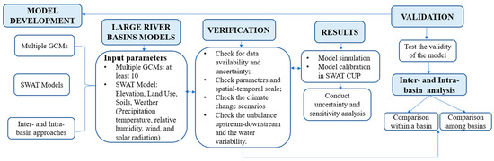
Figure 4.
Verification and validation approach for the modeling tools.
As shown in Figure 4, the model’s implementation is mainly divided into four steps. The first step consists of collecting the input data for SWAT models such as the elevation, land use, soils, and weather (precipitation, temperature, relative humidity, wind, and solar radiation). The second step is to verify the data’s uncertainty, the different parameters, the spatial–temporal scale, and the climate change scenarios. The model’s simulation, calibration, and validation in SWAT CUP, developed by Abbaspour et al. (2007), is the third step [96]. This step involves uncertainty and sensitivity analyses of the model parameters. The fourth step includes the inter- and intra-basin analysis. In this process, the availability, variability, and distribution of water within a basin and among basins are evaluated. Then, a comparison of the inter- and intra-basin results is conducted. It is necessary to check the unbalance between upstream and downstream in order to ensure efficient water allocation among upper and lower reaches.
Inaccuracy and uncertainty in both measured data and model predictions are inherent to hydrological modeling. The climate models could be affected by several sources of uncertainty, including not only the scenario uncertainty, but also internal model responses to radiative forcing levels, and inaccuracies of the models themselves [97]. It was demonstrated that the hydrological model’s uncertainty is less than that of GCM models [98]. A previous study has recommended using at least 10 GCMs in studies of hydrological climate change impacts to thoroughly quantify uncertainty [99]. In addition, it was found that the quality of the available input data (spatial resolution, sample collection methods, timing, analysis methods, etc.) might have a great impact on the results of the model simulation [100]. Therefore, the accuracy and precision of the model can be improved by high-resolution gridding [101]. In SWAT CUP, calibration and uncertainty analyses are closely linked together. For the sensitivity analysis, SWAT uses Latin Hypercube One-Factor-at-a-Time (LH-OAT) [102]. Parameter uncertainties and model input should be considered while processing calibration and validation.
This model is potentially useful for regions where in situ data are limited, as in the case of Madagascar. Moreover, this model could address water allocation and water scarcity at a large basin scale.
4. Conclusions and Recommendations
The main goal of the current study was to develop a systematic review on water resources assessment at a large river basin scale, intending to present a new assessment method for the major river basins in Madagascar. This study has shown that the assessment of water resources across the twelve major river basins in Madagascar is necessary for better monitoring and understanding the hydrological processes across the country.
The analysis of current approaches for water resource assessment has shown that several programs have been designed to assess water resource development and management policies at a large river basin scale. The long-term water balance method was demonstrated as simple, but has several disadvantages because of its inability to simulate and estimate the water resources. The conceptual hydraulic and hydrologic models have been demonstrated to play a vital role in the analysis of water resources, and also in achieving sustainable development. It was also shown that the accuracy of a hydrological model simulation mostly depends on the precipitation accuracy, and several models are now available for researchers. The Dynamic Systems Approach proved to be a helpful tool for stakeholders and policymakers in river basin management.
Our review demonstrated the performance of the SWAT models in conducting water resource assessment and forecasting at the large basin scale worldwide. Several studies have used multiple GCMs with SWAT models in water resource assessment and climate change impact studies to generate more robust scenarios and reduce uncertainty in projecting future climate data. The performance of the SWAT models in the Zambezi River Basin (Zambia), the Volta River Basin (Burkina Faso, Ghana, Togo, Côte d’Ivoire, Mali, and Benin), the Nile River Basin (Ethiopia), and the Congo River Basin (Congo) was found to be effective despite the lack of data and the uncertainty in simulation. Although the use of multiple GCMs and SWAT models is now one of the most widely recognized approaches at the river basin scale worldwide, prior work suggests an improvement in the methods used for water resource assessment within the basin for appropriate water allocation regimes among upper and lower reaches.
The results of our investigation show that water allocation and water scarcity at the basin level could be addressed using the inter- and intra-basin approaches. These approaches present many advantages in allocating the water strategy within a basin and among basins, characterizing the competition and interaction between channels and hillslopes and between adjacent basins, resolving water shortage problems and conflicts, and developing water policy intervention and water management schemes. However, the implementation of inter- and intra-basin water transfer at a large river basin scale has a high financial cost. A scientific direction is recommended to prevent damage to the river’s regime, ecology, sustainability, and environment.
The evidence from this study suggests the combination of the inter- and intra-basin approach with SWAT models and multiple GCMs to assess the water resources at a large river basin scale. This method could contribute to the effective and sustainable management of the river basin. This research extends our knowledge of water resource assessment at the large river basin scale. The present study is valuable for scientists and decision-makers.
The main limitation of this research is that the suggested method for the case study has not been applied yet. However, this manuscript has developed a method that is to be tested for its effective application in Madagascar and possibly other areas. This will be the authors’ next objective.
Author Contributions
Conceptualization, R.Z.H.; brainstorming, R.Z.M.H.; methodology, R.Z.H. and I.H.; writing—original draft preparation, R.Z.H.; writing—review and editing, R.Z.H., R.Z.M.H. and I.H.; supervision, I.H., M.J. and S.K. All authors have read and agreed to the published version of the manuscript.
Funding
This work was supported by JST, the establishment of University fellowships towards the creation of science and technology innovation, Grant Number JPMJFS2117, University of Yamanashi.
Institutional Review Board Statement
Not applicable.
Informed Consent Statement
Not applicable.
Data Availability Statement
The study did not report any data.
Acknowledgments
The authors sincerely thank the editor and the anonymous reviewers for reviewing the manuscript and providing valuable comments to improve the manuscript.
Conflicts of Interest
The authors declare no conflict of interest.
References
- Boretti, A.; Rosa, L. Reassessing the projections of the world water development report. NPJ Clean Water 2019, 1, 15. [Google Scholar] [CrossRef]
- McNally, A.; Verdin, K.; Harrison, L.; Getirana, A.; Jacob, J.; Shukla, S.; Arsenault, K.; Peters-Lidard, C.; Verdin, J.P. Acute water-scarcity monitoring for Africa. Water 2019, 11, 1968. [Google Scholar] [CrossRef]
- Vallee, D.; Margat, J.; Eliasson, A.; Hoogeveen, J. Review of World Water Resources by Country; Food and Agricultural Organization of the United Nations: Rome, Italy, 2003. [Google Scholar]
- Manungufala, T. Water Scarcity: Classification, Measurement and Management. In Clean Water and Sanitation. Encyclopedia of the UN Sustainable Development Goals; Leal Filho, W., Azul, A.M., Brandli, L., Lange Salvia, A., Wall, T., Eds.; Springer: Cham, Switzerland, 2021. [Google Scholar] [CrossRef]
- Purvis, L.; Dinar, A. Are intra-and inter-basin water transfers a sustainable policy intervention for addressing water scarcity? Water Secur. 2020, 9, 100058. [Google Scholar] [CrossRef]
- Wada, Y.; Flörke, M.; Hanasaki, N.; Eisner, S.; Fischer, G.; Tramberend, S.; Satoh, Y.; van Vliet, M.T.H.; Yillia, P.; Ringler, C.; et al. Modeling global water use for the 21st century: The Water Futures and Solutions (WFaS) initiative and its approaches. Geosci. Model Dev. 2016, 9, 175–222. [Google Scholar] [CrossRef]
- Schewe, J.; Heinke, J.; Gerten, D.; Haddeland, I.; Arnell, N.W.; Clark, D.B.; Dankers, R.; Eisner, S.; Fekete, B.M.; Colón-González, F.J.; et al. Multimodel assessment of water scarcity under climate change. Proc. Natl. Acad. Sci. USA 2014, 111, 3245–3250. [Google Scholar] [CrossRef] [PubMed]
- Falkenmark, M.; Anders, B.; Anders, J.; Jan, L.; Manfred, M.; Håkan, T. On the Verge of a New Water Scarcity: A Call for Good Governance and Hyman Ingenuity; International Water Institute (SIWI): Stockholm, Sweden, 2007. [Google Scholar]
- Elimelech, M. The global challenge for adequate and safe water. J. Water Supply: Res. Technol. AQUA 2006, 55, 3–10. [Google Scholar] [CrossRef]
- Munia, H.; Guillaume, J.H.A.; Mirumachi, N.; Porkka, M.; Yoshihide, W.; Kummu, M. Water stress in global transboundary river basins: Significance of upstream water use on downstream stress. Environ. Res. Lett. 2016, 11, 014002. [Google Scholar] [CrossRef]
- UN Water. UN World Water Development Report, Nature-Based Solutions for Water; UNESCO: Paris, France, 2018. [Google Scholar]
- Falkenmark, M. Planning of Africa’s land/water future: Hard or soft landing? Ambio 2022, 51, 9–12. [Google Scholar] [CrossRef]
- Rakotoarimanana, Z.H.; Ishidaira, H. Analysis of River Basin Management in Madagascar and Lessons Learned from Japan. Water 2022, 14, 449. [Google Scholar]
- Cesar, C.M.; Crestaz, E.; Cimmarrusti, Y.; Farinosi, F.; Biedler, M.; Amani, A.; Mishra, A. Implementing the Water–Energy–Food–Ecosystems Nexus and Achieving the Sustainable Development Goals; IWA: London, UK, 2021; ISBN 9789231004735. [Google Scholar]
- World Meteorological Organization. State of the Climate in Africa 2019; WMO-No. 1253; World Meteorological Organization: Geneva, Switzerland, 2020. [Google Scholar]
- Guha-Sapir, D.; Hoyois, P.; Below, R. Annual Disaster Statistical Review 2015: The Numbers and Trends; Centre for Research on the Epidemiology of Disasters (CRED): Brussels, Belgium, 2016. [Google Scholar]
- World Meteorological Organization. Technical Material for Water Resources Assessment; WMO-No.2; World Meteorological Organization: Geneva, Switzerland, 2012. [Google Scholar]
- Batchelor, C.; Moriarty, P.; Laban, P. Using water resources assessments within the EMPOWER IWRM planning cycle. EMPOWERS Work. Pap. 2005, 5, 30. [Google Scholar]
- Martin, E.; Gascoin, S.; Grusson, Y.; Murgue, C.; Bardeau, M.; Anctil, F.; Ferrant, S.; Lardy, R.; Le Moigne, P.; Leenhardt, D.; et al. On the use of hydrological models and satellite data to study the water budget of river basins affected by human activities: Examples from the Garonne basin of France. In Remote Sensing and Water Resources; Springer: Cham, Switzerland, 2016; pp. 33–57. [Google Scholar]
- Cao, X.; Cuyuzuzo, C.M.; Saiken, A.; Song, B. A linear additivity water resources assessment indicator by combining water quantity and water quality. Ecol. Indic. 2021, 121, 106990. [Google Scholar] [CrossRef]
- Luo, P.; Sun, Y.; Wang, S.; Wang, S.; Lyu, J.; Zhou, M.; Nakagami, K.; Takara, K.; Nover, D. Historical assessment and future sustainability challenges of Egyptian water resources management. J. Clean. Prod. 2020, 263, 121154. [Google Scholar] [CrossRef]
- Andrade, C.W.L.; Montenegro, S.M.G.L.; Montenegro, A.A.A.; Lima, J.R.D.S.; Srinivasan, R.; Jones, C.A. Climate change impact assessment on water resources under RCP scenarios: A case study in Mundaú River Basin, Northeastern Brazil. Int. J. Climatol. 2021, 41, E1045–E1061. [Google Scholar] [CrossRef]
- Cuceloglu, G.; Abbaspour, K.C.; Ozturk, I. Assessing the water-resources potential of Istanbul by using a soil and water assessment tool (SWAT) hydrological model. Water 2017, 9, 814. [Google Scholar] [CrossRef]
- Lins, H.F. The imperative of water resources assessment. World Meteorol. Organ. WMO Bull. 2008, 57, 159. [Google Scholar]
- Biancamaria, S.; Bates, P.D.; Boone, A.; Mognard, N.M. Large-scale coupled hydrologic and hydraulic modelling of the Ob river in Siberia. J. Hydrol. 2009, 379, 136–150. [Google Scholar] [CrossRef]
- Chomba, I.C.; Banda, K.E.; Winsemius, H.C.; Chomba, M.J.; Mataa, M.; Ngwenya, V.; Sichingabula, H.M.; Nyambe, I.A.; Ellender, B. A review of coupled hydrologic-hydraulic models for floodplain assessments in Africa: Opportunities and challenges for floodplain wetland management. Hydrology 2021, 8, 44. [Google Scholar] [CrossRef]
- Nunes Correia, F.; Castro Rego, F.; Da Grača Saraiva, M.; Ramos, I. Coupling GIS with hydrologic and hydraulic flood modelling. Water Resour. Manag. 1998, 12, 229–249. [Google Scholar] [CrossRef]
- Pontes, P.R.M.; Fan, F.M.; Fleischmann, A.S.; de Paiva, R.C.D.; Buarque, D.C.; Siqueira, V.A.; Jardim, P.F.; Sorribas, M.V.; Collischonn, W. MGB-IPH model for hydrological and hydraulic simulation of large floodplain river systems coupled with open source GIS. Environ. Model. Softw. 2017, 94, 1–20. [Google Scholar] [CrossRef]
- McKinney, D.C.; Cai, X.; Rosegrant, M.W.; Ringler, C.; Scott, A.C. Modeling Water Resources Management at the Basin Level: Review and Future Directions; SWIM Paper 6; International Water Management Institute: Colombo, Sri Lanka, 1999. [Google Scholar]
- Xu, C.-Y.; Singh, V.P. Review on regional water resources assessment models under stationary and changing climate. Water Resour. Manag. 2004, 18, 591–612. [Google Scholar] [CrossRef]
- Rayburg, S.; Thoms, M. A coupled hydraulic–hydrologic modelling approach to deriving a water balance model for a complex floodplain wetland system. Hydrol. Res. 2009, 40, 364–379. [Google Scholar] [CrossRef]
- Sui, D.Z.; Maggio, R.C. Integrating GIS with hydrological modeling: Practices, problems, and prospects. Comput. Environ. Urban Syst. 1999, 23, 33–51. [Google Scholar] [CrossRef]
- Brown, C.M.; Lund, J.R.; Cai, X.; Reed, P.M.; Zagona, E.A.; Ostfeld, A.; Hall, J.; Characklis, G.W.; Yu, W.; Brekke, L. The future of water resources systems analysis: Toward a scientific framework for sustainable water management. Water Resour. Res. 2015, 51, 6110–6124. [Google Scholar] [CrossRef]
- Nsubuga, F.N.; Namutebi, E.N.; Nsubuga-Ssenfuma, M. Water resources of Uganda: An assessment and review. J. Water Resour. Prot. 2014, 6, 1297. [Google Scholar] [CrossRef]
- Shahin, M. Review and assessment of water resources in the Arab region. Water Int. 1989, 14, 206–219. [Google Scholar] [CrossRef]
- Digna, R.F.; Mohamed, Y.A.; Van Der Zaag, P.; Uhlenbrook, S.; Corzo, G.A. Nile River Basin modelling for water resources management–a literature review. Int. J. River Basin Manag. 2017, 15, 39–52. [Google Scholar] [CrossRef]
- Khan, K.S.; Kunz, R.; Kleijnen, J.; Antes, G. Five steps to conducting a systematic review. J. R. Soc. Med. 2003, 96, 118–121. [Google Scholar] [CrossRef]
- Xiao, Y.; Watson, M. Guidance on conducting a systematic literature review. J. Plan. Educ. Res. 2019, 39, 93–112. [Google Scholar] [CrossRef]
- Mietton, M.; Gunnell, Y.; Andriamitia, J.; Crouzet, C.; Montade, V.; Jouannic, G.; Nicoud, G.; Razafimahefa, R. Neotectonics and pastoralism: How they impact flood regimes in Madagascar’s highlands. Sci. Total Environ. 2020, 10, 140633. [Google Scholar] [CrossRef]
- Bastaraud, A.; Perthame, E.; Rakotondramanga, J.M.; Mahazosaotra, J.; Ravaonindrina, N.; Jambou, R. The impact of rainfall on drinking water quality in Antananarivo, Madagascar. PLoS ONE 2020, 15, e0218698. [Google Scholar] [CrossRef]
- Brosens, L.; Broothaerts, N.; Campforts, B.; Jacobs, L.; Razanamahandry, V.F.; Van Moerbeke, Q.; Bouillon, S.; Razafimbelo, T.; Rafolisy, T.; Govers, G. Under pressure: Rapid lavaka erosion and floodplain sedimentation in central Madagascar. Sci. Total Environ. 2022, 806, 150483. [Google Scholar] [CrossRef] [PubMed]
- Rabezanahary Tanteliniaina, M.F.; Rahaman, M.H.; Zhai, J. Assessment of the future impact of climate change on the hydrology of the Mangoky River, Madagascar using ANN and SWAT. Water 2021, 13, 1239. [Google Scholar] [CrossRef]
- Andriambeloson, J.A.; Paris, A.; Calmant, S.; Rakotondraompiana, S. Re-initiating depth-discharge monitoring in small-sized ungauged watersheds by combining remote sensing and hydrological modelling: A case study in Madagascar. Hydrol. Sci. J. 2020, 65, 2709–2728. [Google Scholar] [CrossRef]
- Maina, J.; de Moel, H.; Vermaat, J.E.; Bruggemann, J.H.; Guillaume, M.M.; Grove, C.A.; Madin, J.S.; Mertz-Kraus, R.; Zinke, J. Linking coral river runoff proxies with climate variability, hydrology and land-use in Madagascar catchments. Mar. Pollut. Bull. 2012, 64, 2047–2059. [Google Scholar] [CrossRef] [PubMed]
- Damkjaer, S.; Taylor, R. The measurement of water scarcity: Defining a meaningful indicator. Ambio 2017, 46, 513–531. [Google Scholar] [CrossRef]
- Singh, V.P. Hydrologic modeling: Progress and future directions. Geosci. Lett. 2018, 5, 15. [Google Scholar] [CrossRef]
- Didovets, I.; Krysanova, V.; Hattermann, F.F.; López, M.D.R.R.; Snizhko, S.; Schmied, H.M. Climate change impact on water availability of main river basins in Ukraine. J. Hydrol. Reg. Stud. 2020, 32, 100761. [Google Scholar] [CrossRef]
- Mallen-Cooper, M.; Brenton, P.Z. History, hydrology and hydraulics: Rethinking the ecological management of large rivers. Ecohydrology 2018, 11, e1965. [Google Scholar] [CrossRef]
- Hamududu, B.H.; Hambulo, N. Impacts of climate change on water resources availability in Zambia: Implications for irrigation development. Environ. Dev. Sustain. 2020, 22, 2817–2838. [Google Scholar] [CrossRef]
- Gelebo, A.H.; Kasiviswanathan, K.S.; Khare, D. Assessment of the spatial–temporal distribution of groundwater recharge in data-scarce large-scale African river basin. Environ. Monit. Assess. 2022, 194, 157. [Google Scholar] [CrossRef]
- Pérez-Martín, M.A.; Estrela, T.; Andreu, J.; Ferrer, J. Modeling water resources and river-aquifer interaction in the Júcar River Basin, Spain. Water Resour. Manag. 2014, 28, 4337–4358. [Google Scholar] [CrossRef]
- Guan, X.; Zhang, J.; Elmahdi, A.; Li, X.; Liu, J.; Liu, Y.; Jin, J.; Liu, Y.; Bao, Z.; Liu, C.; et al. The capacity of the hydrological modeling for water resource assessment under the changing environment in semi-arid river basins in China. Water 2019, 11, 1328. [Google Scholar] [CrossRef]
- Tshimanga, R.M.; Hughes, D.A. Basin-scale performance of a semidistributed rainfall-runoff model for hydrological predictions and water resources assessment of large rivers: The Congo River. Water Resour. Res. 2014, 50, 1174–1188. [Google Scholar] [CrossRef]
- Sibanda, M.; Mutanga, O.; Chimonyo, V.G.P.; Clulow, A.D.; Shoko, C.; Mazvimavi, D.; Dube, T.; Mabhaudhi, T. Application of drone technologies in surface water resources monitoring and assessment: A systematic review of progress, challenges, and opportunities in the global south. Drones 2021, 5, 84. [Google Scholar] [CrossRef]
- Yan, J.; Jia, S.; Lv, A.; Zhu, W. Water resources assessment of China’s transboundary river basins using a machine learning approach. Water Resour. Res. 2019, 55, 632–655. [Google Scholar] [CrossRef]
- Sánchez-Román, R.M.; Folegatti, M.V.; Orellana, A.M.G. Water resources assessment at Piracicaba, Capivari and Jundiaí River Basins: A dynamic systems approach. Water Resour. Manag. 2010, 24, 761–773. [Google Scholar] [CrossRef]
- Kotir, J.H.; Smith, C.; Brown, G.; Marshall, N.; Johnstone, R. A system dynamics simulation model for sustainable water resources management and agricultural development in the Volta River Basin, Ghana. Sci. Total Environ. 2016, 573, 444–457. [Google Scholar] [CrossRef]
- Du, E.; Tian, Y.; Cai, X.; Zheng, Y.; Li, X.; Zheng, C. Exploring spatial heterogeneity and temporal dynamics of human-hydrological interactions in large river basins with intensive agriculture: A tightly coupled, fully integrated modeling approach. J. Hydrol. 2020, 591, 125313. [Google Scholar] [CrossRef]
- Yang, Q.; Almedinger, J.E.; Zhang, X.; Huang, M.; Chen, X.; Leng, G.; Zhou, Y.; Zhao, K.; Asrar, G.R.; Srinivasan, R.; et al. Enhancing SWAT simulation of forest ecosystems for water resource assessment: A case study in the St. Croix River basin. Ecol. Eng. 2018, 120, 422–431. [Google Scholar] [CrossRef]
- Sholagberu, A.T.; Okikiola, F.O.; Bashir, A.; Adeniyi, A.S.; Juliana, I.O.; Muhammad, M.M.; Abdurrasheed, A.S. Performance Evaluation of SWAT-based Model for the Prediction of Potential and Actual Evapotranspiration. Jordan J. Civ. Eng. 2022, 16, 1–11. [Google Scholar]
- Gebrechorkos, S.H.; Bernhofer, C.; Hülsmann, S. Climate change impact assessment on the hydrology of a large river basin in Ethiopia using a local-scale climate modelling approach. Sci. Total Environ. 2020, 742, 140504. [Google Scholar] [CrossRef] [PubMed]
- Nematchoua, M.K.; Ricciardi, P.; Orosa, J.A.; Buratti, C. A detailed study of climate change and some vulnerabilities in Indian Ocean: A case of Madagascar island. Sustain. Cities Soc. 2018, 41, 886–898. [Google Scholar] [CrossRef]
- Didovets, I.; Lobanova, A.; Bronstert, A.; Snizhko, S.; Maule, C.F.; Krysanova, V. Assessment of climate change impacts on water resources in three representative Ukrainian catchments using eco-hydrological modelling. Water 2017, 9, 204. [Google Scholar] [CrossRef]
- Hooshyar, M.; Singh, A.; Wang, D. Interbasin and intrabasin competitions control drainage network density. Geophys. Res. Lett. 2019, 46, 661–669. [Google Scholar] [CrossRef]
- Jackson, R.B.; Carpenter, S.R.; Dahm, C.N.; McKnight, D.M.; Naiman, R.J.; Postel, S.L.; Running, S.W. Water in a changing world. Ecol. Appl. 2001, 11, 1027–1045. [Google Scholar] [CrossRef]
- Lopes, T.R.; Zolin, C.A.; Mingoti, R.; Vendrusculo, L.G.; de Almeida, F.T.; de Souza, A.P.; de Oliveira, R.F.; Paulino, J.; Uliana, E.M. Hydrological regime, water availability and land use/land cover change impact on the water balance in a large agriculture basin in the Southern Brazilian Amazon. J. S. Am. Earth Sci. 2021, 108, 103224. [Google Scholar] [CrossRef]
- Takele, G.S.; Geremew, S.G.; Azage, G.G.; Agizew, N.E. Hydrological modeling in the Upper Blue Nile basin using soil and water analysis tool (SWAT). Modeling Earth Syst. Environ. 2022, 8, 277–292. [Google Scholar] [CrossRef]
- Swain, S.S.; Ashok, M.; Bhabagrahi, S.; Chandranath, C. Water scarcity-risk assessment in data-scarce river basins under decadal climate change using a hydrological modelling approach. J. Hydrol. 2020, 590, 125260. [Google Scholar] [CrossRef]
- Mengistu, D.; Bewket, W.; Dosio, A.; Panitz, H.J. Climate change impacts on water resources in the upper blue nile (Abay) river basin, ethiopia. J. Hydrol. 2021, 592, 125614. [Google Scholar] [CrossRef]
- Shen, Y.; Taikan, O.; Shinjiro, K.; Naota, H.; Nobuyuki, U.; Masashi, K. Projection of future world water resources under SRES scenarios: An integrated assessment. Hydrol. Sci. J. 2014, 59, 1775–1793. [Google Scholar] [CrossRef]
- Almazroui, M.; Islam, M.N.; Saeed, F.; Saeed, S.; Ismail, M.; Ehsan, M.A.; Diallo, I.; O’Brien, E.; Ashfaq, M.; Martínez-Castro, D.; et al. Projected changes in temperature and precipitation over the United States, Central America, and the Caribbean in CMIP6 GCMs. Earth Syst. Environ. 2021, 5, 1–24. [Google Scholar] [CrossRef]
- Gu, H.; Yu, Z.; Wang, G.; Wang, J.; Ju, Q.; Yang, C.; Fan, C. Impact of climate change on hydrological extremes in the Yangtze River Basin, China. Stoch. Environ. Res. Risk Assess. 2015, 29, 693–707. [Google Scholar] [CrossRef]
- Lee, J.; De Gryze, S.S.J. Effect of climate change on field crop production in the Central Valley of California. Clim. Change 2011, 109, 335–353. [Google Scholar] [CrossRef]
- Arnold, J.G.; Srinivasan, R.; Muttiah, R.S.; Williams, J.R. Large area hydrologic modeling and assessment part I: Model development 1. J. Am. Water Resour. Assoc. 1998, 34, 73–89. [Google Scholar] [CrossRef]
- Akoko, G.; Tu, H.L.; Takashi, G.; Tasuku, K. A review of SWAT model application in Africa. Water 2021, 13, 1313. [Google Scholar] [CrossRef]
- Krysanova, V.; White, M. Advances in water resources assessment with SWAT—An overview. Hydrol. Sci. J. 2015, 60, 771–783. [Google Scholar] [CrossRef]
- Mul, M.; Obuobie, E.; Appoh, R.; Kankam-Yeboah, K.; Bekoe-Obeng, E.; Amisigo, B.; Logah, F.Y.; Gnansah, B.; McCartney, M. Water Resources Assessment of the Volta River Basin; IWMI Working Paper 166; International Water Management Institute (IWMI): Colombo, Sri Lanka, 2015. [Google Scholar]
- Eastham, J.; Mpelasoka, F.; Mainuddin, M.; Ticehurst, C.; Dyce, P.; Hodgson, G.; Ali, R.; Kirby, M. Mekong River Basin Water Resources Assessment: Impacts of Climate Change; CSIRO: Canberra, Australia, 2008. [Google Scholar]
- Shrestha, N.K.; Du, X.; Wang, J. Assessing climate change impacts on fresh water resources of the Athabasca River Basin, Canada. Sci. Total Environ. 2017, 601, 425–440. [Google Scholar] [CrossRef]
- Tan, M.L.; Ibrahim, A.L.; Yusop, Z.; Chua, V.P.; Chan, N.W. Climate change impacts under CMIP5 RCP scenarios on water resources of the Kelantan River Basin, Malaysia. Atmos. Res. 2017, 189, 1–10. [Google Scholar] [CrossRef]
- Chen, J.; Gao, C.; Zeng, X.; Xiong, M.; Wang, Y.; Jing, C.; Krysanova, V.; Huang, J.; Zhao, N.; Su, B. Assessing changes of river discharge under global warming of 1.5 C and 2 C in the upper reaches of the Yangtze River Basin: Approach by using multiple-GCMs and hydrological models. Quat. Int. 2017, 453, 63–73. [Google Scholar] [CrossRef]
- Tegegne, G.; Park, D.K.; Kim, Y.-O. Comparison of hydrological models for the assessment of water resources in a data-scarce region, the Upper Blue Nile River Basin. J. Hydrol. Reg. Stud. 2017, 14, 49–66. [Google Scholar] [CrossRef]
- Tegegne, G.; Park, D.K.; Kim, Y.; Kim, Y.-O. Selecting hydrologic modelling approaches for water resource assessment in the Yongdam watershed. J. Hydrol. 2017, 56, 155–164. [Google Scholar]
- Guiamel, I.A.; Han, S.L. Watershed modelling of the Mindanao River Basin in the Philippines using the SWAT for water resource management. Civ. Eng. J. 2020, 6, 626–648. [Google Scholar] [CrossRef]
- Xie, P.; Zhuo, L.; Yang, X.; Huang, H.; Gao, X.; Wu, P. Spatial-temporal variations in blue and green water resources, water footprints and water scarcities in a large river basin: A case for the Yellow River basin. J. Hydrol. 2020, 590, 125222. [Google Scholar] [CrossRef]
- Zhang, Y.; Ma, J.; Chang, X.; van Wonderen, J.; Yan, L.; Han, J. Water resources assessment in the Minqin Basin: An arid inland river basin under intensive irrigation in northwest China. Environ. Earth Sci. 2012, 65, 1831–1839. [Google Scholar] [CrossRef]
- Davies, B.R.; Thoms, M.; Meador, M. An assessment of the ecological impacts of inter-basin water transfers, and their threats to river basin integrity and conservation. Aquat. Conserv. Mar. Freshw. Ecosyst. 1992, 2, 325–349. [Google Scholar] [CrossRef]
- Wolf, A.T. Shared waters: Conflict and cooperation. Annu. Rev. Environ. Resour. 2007, 32, 241–269. [Google Scholar] [CrossRef]
- Verdhen, A. Intra and inter basin linking of rivers in water resources management. J. Sci. Ind. Res. 2016, 75, 150–155. [Google Scholar]
- Snaddon, C.D.; Davies, B.R.; Wishart, M.J.; Meador, M.E.; Thoms, M.C. A Global Overview of Inter-Basin Water Transfer Schemes, with an Appraisal of Their Ecological, Socio-Economic and Socio-Political Implications, and Recommendations for Their Management; Water Research Commission Report No. TT120/00; Water Research Commission: Pretoria, South Africa, 1999. [Google Scholar]
- Nasiri-Gheidari, O.; Safar, M.; Farzaneh, A. A robust multi-objective bargaining methodology for inter-basin water resource allocation: A case study. Environ. Sci. Pollut. Res. 2018, 25, 2726–2737. [Google Scholar] [CrossRef]
- Sun, S.; Zhou, X.; Liu, H.; Jiang, Y.; Zhou, H.; Zhang, C.; Fu, G. Unraveling the effect of inter-basin water transfer on reducing water scarcity and its inequality in China. Water Res. 2021, 194, 116931. [Google Scholar] [CrossRef]
- Shumilova, O.; Tockner, K.; Thieme, M.; Koska, A.; Zarfl, C. Global water transfer megaprojects: A potential solution for the water-food-energy nexus? Front. Environ. Sci. 2018, 6, 150. [Google Scholar] [CrossRef]
- Huang, S.; Shah, H.; Naz, B.S.; Shrestha, N.; Mishra, V.; Daggupati, P.; Ghimire, U.; Vetter, T. Impacts of hydrological model calibration on projected hydrological changes under climate change—A multi-model assessment in three large river basins. Clim. Change 2020, 163, 1143–1164. [Google Scholar] [CrossRef]
- American Institute of Aeronautics and Astronautics. Guide for the Verification and Validation of Computational Fluid Dynamics Simulations; AIAA-G-077-1998; American Institute of Aeronautics and Astronautics: Reston, VA, USA, 1998. [Google Scholar]
- Abbaspour, K.C.; Vejdani, M.; Haghighat, S. SWAT CUP calibration and uncertainty programs for SWAT. In Proceedings of the International Congress on Modelling and Simulation (MODSIM’07), Christchurch, New Zealand, 10–13 December 2007; Oxley, L., Kulasiri, D., Eds.; Modelling and Simulation Society of Australia and New Zealand: Melbourne, Australia, 2007; pp. 1603–1609. [Google Scholar]
- Solman, S.A.; Bettolli, M.L.; Doyle, M.E.; Olmo, M.E.; Feijoó, M.; Martinez, D.; Blazquez, J.; Balmaceda Huarte, R. Evaluation of multiple downscaling tools for simulating extreme precipitation events over Southeastern South America: A case study approach. Clim. Dyn. 2021, 57, 1241–1264. [Google Scholar] [CrossRef]
- Thompson, J.R.; Green, A.J.; Kingston, D.G.; Gosling, S.N. Assessment of uncertainty in river flow projections for the Mekong River using multiple GCMs and hydrological models. J. Hydrol. 2013, 486, 1–30. [Google Scholar] [CrossRef]
- Wang, H.M.; Chen, J.; Xu, C.Y.; Zhang, J.; Chen, H. A framework to quantify the uncertainty contribution of GCMs over multiple sources in hydrological impacts of climate change. Earth’s Future 2020, 8, e2020EF001602. [Google Scholar] [CrossRef]
- Song, X.; Zhang, J.; Zhan, C.; Xuan, Y.; Ye, M.; Xu, C. Global sensitivity analysis in hydrological modeling: Review of concepts, methods, theoretical framework, and applications. J. Hydrol. 2015, 523, 739–757. [Google Scholar] [CrossRef]
- Daggupati, P.; Pai, N.; Ale, S.; Douglas-Mankin, K.R.; Zeckoski, R.W.; Jeong, J.; Parajuli, P.B.; Saraswat, D.; Youssef, M.A. A recommended calibration and validation strategy for hydrologic and water quality models. Trans. ASABE 2015, 58, 1705–1719. [Google Scholar]
- Van Griensven, A. Sensitivity, auto-calibration, uncertainty and model evaluation in SWAT 2005. UNESCO-IHE 2005, 48, 25. [Google Scholar]


Publisher’s Note: MDPI stays neutral with regard to jurisdictional claims in published maps and institutional affiliations. |
© 2022 by the authors. Licensee MDPI, Basel, Switzerland. This article is an open access article distributed under the terms and conditions of the Creative Commons Attribution (CC BY) license (https://creativecommons.org/licenses/by/4.0/).