Article

OUV Analysis and Global Comparative Study of Karakoram-Pamir World Natural Heritage Potential Area

1
State Key Laboratory of Desert and Oasis Ecology, Xinjiang Institute of Ecology and Geography, Chinese Academy of Sciences, Urumqi 830011, China
2
University of Chinese Academy of Sciences, Beijing 100049, China
3
College of Tourism, Xinjiang University of Finance and Economics, Urumqi 830012, China
*
Author to whom correspondence should be addressed.
Sustainability 2022, 14(19), 12546; https://doi.org/10.3390/su141912546
Submission received: 2 September 2022 / Revised: 22 September 2022 / Accepted: 26 September 2022 / Published: 1 October 2022

Abstract

:
The analysis and global comparison of World Natural Heritage values are important for the assessment of World Natural Heritage and are relevant for the sustainable development of the nominated potential areas. Pamir Plateau, known as the “Spring Ridge”, with the world’s largest mountain junction—Pamir mountain junction—is known as the ancestor of mountains and the source of rivers. The nominated Karakorum-Pamir site was inscribed on the World Heritage Tentative List in 2010. In this paper, the characteristics of heritage resources in two areas of the Karakoram-Pamir heritage potential area are systematically analyzed according to the standard of Outstanding Universal Value (OUV) of world heritage by comprehensive analysis and geographical comparison. It puts forward that the aesthetics, geology, and biological ecology of this region are of global outstanding universal value. It is concluded that the Karakoram-Pamir Heritage Potential area meets the criteria of world natural Heritage (VII), (VIII), and (X). By comparing with 15 large mountain heritages listed in the World Heritage list, it is concluded that the Karakoram-Pamir area in Xinjiang has an OUV of world heritage and a potential of declaring world natural heritage. This study lays a scientific foundation for the declaration of Xinjiang Karakoram-Pamir as a World Heritage site.

1. Introduction

The World Heritage Center’s Convention Concerning the Protection of the World Cultural and Natural Heritage defines natural heritage as follows: a natural World Heritage is a natural feature consisting of organisms and their environment of outstanding universal value from an aesthetic or scientific point of view; a geological feature unit and threatened habitat of flora and fauna of outstanding universal value from a scientific or conservation point of view; a natural beauty or nature conservation site of outstanding universal value from a scientific, conservation, or natural beauty point of view [1]. The World Heritage Site is regarded as the pinnacle achievement in environmental conservation, successfully preserving the most significant ecosystems, rare and endangered species, natural landmarks, and essential elements of landscapes, and is the most outstanding area of universal value and representation of the essence of natural ecosystems on a global scale. China joined the Heritage Convention in November 1985 and launched the World Heritage nomination process in 1986 [2]. As of December 2020, China has nominated 14 successful natural world heritage sites. Xinjiang is located in the arid region of northwest China, accounting for about 1/6 of China’s land area. Its unique geographical location, mountain-basin landscape, and climatic and environmental patterns have created naturally geographical features and natural landscapes that are unique in the world, but at present, Xinjiang has only one World Natural Heritage Site, the Xinjiang Tianshan, which is seriously under-represented on the World Heritage List. The Karakorum Mountains and the Pamir Plateau are both areas strongly encouraged by the World Heritage Committee, part of which is located in China’s Xinjiang Uyghur Autonomous Region, and the Karakorum-Pamir Mountains were inscribed on China’s World Heritage Tentative List in 2010 and have the potential for natural heritage nomination.
The assessment of Outstanding Universal Value plays a decisive role in the process of natural heritage nomination, and therefore, the study of the value of the nominated sites of the Karakorum-Pamir group of peaks is particularly important. In the Operational Guidelines for the Implementation of the World Heritage Convention proposed by the United Nations Educational, Scientific, and Cultural Organization (UNESCO), there are four criteria for the Outstanding Universal Value of Natural World Heritage Sites [3], namely Criterion VII for aesthetic value, Criterion VIII for geological value, Criterion IX for ecological value, and Criterion X for biological value. According to the experience of successful World Natural Heritage nominations, a World Natural Heritage Site should meet at least one of the outstanding universal values of the World Natural Heritage Convention and be globally unique to be inscribed on the World Natural Heritage List. Of the 218 natural World Heritage properties currently inscribed on the World Natural Heritage List, 56 natural World Heritage properties are inscribed under one criterion, 104 natural World Heritage properties are inscribed under two criteria, 38 natural World Heritage properties are inscribed under three criteria, and 19 natural World Heritage properties are inscribed under four criteria. Of these, the proportion of high-value natural heritage properties successfully inscribed under 3–4 universal values is only 26.27, indicating that the number of high-value natural heritage properties is scarce. Among the four criteria, more than 50% of natural heritage properties meet Outstanding Universal Value VII and IX, while Outstanding Universal Value VIII is value-deficient, accounting for 37% of the total, indicating that the number of natural heritage properties inscribed on the List by geological criteria is also scarce. In the process of nomination to the Tentative List, experts from the United Nations Heritage Centre and Chinese heritage experts jointly examined the Karakorum-Pamir Peaks, the subject of this study, and proposed three outstanding universal value criteria for its compliance with the World Natural Heritage value, with value VIII being one of the important nomination criteria, which further confirms that “This confirms the importance of scientific research on the value of the Karakorum-Pamir peaks”.
The four Outstanding Universal Value [3] Criteria for Natural World Heritage in the Operational Guidelines for the Implementation of the World Heritage Convention proposed by the United Nations Educational, Scientific, and Cultural Organization (UNESCO) include four aspects: aesthetics, geology, ecology, and biology. This paper draws on the findings of international and domestic scholars on the value of mountainous natural heritage, and examines the outstanding universal value of the Karakorum-Pamir from the four aspects mentioned above. Cunha traced the evolution of the protected area system and the natural heritage nomination process in the Pamir Mountains of Tajikistan, describing its outstanding universal value following Articles (VII) and (VIII) of the Natural Heritage [4]. Han et al. (2018) and Deng Wugong briefly described the natural condition and aesthetic and bioecological values of the Hoh Xil, Qinghai natural heritage site, and analyzed that Hoh Xil, Qinghai meets the outstanding universal values of World Natural Heritage Article (VII) and Article (X) [5]. Kim described Articles (VII) and (VIII) of the Rocky Mountain Natural Heritage as highlighting universal values [6]. Yang Zhaoping et al. conducted a global comparison of aesthetic and bioecological heritage values for the Kanas natural heritage site and proposed criteria (VII) and (IX) for meeting the outstanding universal values of natural world heritage [7].
The most important question that needs to be addressed in this paper is whether the values proposed by the experts are globally unique, based on a study of values, using a global comparison of the shared values of similar extreme alpine mountain properties worldwide. In the World Heritage Tentative List nomination file, the comparison file for the Karakorum-Pamir nomination site only includes European natural extreme mountain properties, which are under-represented. Therefore, this paper proposes a model based on the outstanding universal value of natural heritage, comparing similar mountain properties worldwide with the same universal value, and using expert scoring to verify the global uniqueness of the Karakorum-Pamir nominated sites. At the same time, the paper attempts to develop a model that can be used as a reference for future nominations of mountain-based natural heritage sites.

2. Overview of the Study Area and Study Methods

2.1. The Study Area

Pamirs Plateau, located in the hinterland of Eurasia, across China, Tajikistan, and Afghanistan, is the world’s largest mountain junction formed by the five major mountain systems of Tianshan, Karakoram, Himalaya, Kunlun, and Hindu Kush [8], and it is the birthplace of the Indus, Amu Darya, and Tarim river upstream of Ye Erwu River, about more than 10 square kilometers [9]. Pamir Plateau, known as the “Spring Ridge”, with the world’s largest mountain junction—Pamir mountain junction—is known as the ancestor of mountains and the source of rivers.
Karakoram-Pamir’s potential heritage areas are located in Yecheng County, Tashkurgan County, Akto County, Kirgiz Autonomous Prefecture, Kashgar, and Xinjiang, including Xinjiang Tashikuergan Wildlife Nature Reserve, Muztagh Glacier Park (Table 1), with a total area of 19,201.4 km2. It is located in the south of Tashkurgan Tajik Autonomous County, Xinjiang [10], spanning 35°35′35.357″~37°30′28.244″ N, 74°27′11.986″~77°6’32.122″ E, 180 km east–west, and 210 km north–south, with a total area of 16,140 km2 [11]. In terms of geological value, it should include Kongur Shan, Kongur Tobe Feng, and Muztag Ata Peak, and in terms of biological and ecological value, it partially overlaps with the Pamir Plateau Wetland Nature Reserve. The Pamir Plateau Wetland Nature Reserve is located at the junction of Muji and Burenkou townships in Aketao County, Kizilsu Kirgiz Autonomous Prefecture, and Tashkurgan Tajik Autonomous County, Kashgar Region, at an altitude of 3300–3800 m, with a total area of 1255.767 km2 [12]. The study area was finally determined as follows (Figure 1).

2.2. Study Methods

2.2.1. Field Inquiry Method

After more than a decade of field research in the potential heritage area, the project team combined historical data to study and calculate the types and quantities of plant species, rare and endangered species, natural beauty, and cultural relics. As the average altitude of the nominated sites exceeds 3500 m and some areas exceed 5000 m, and they are close to the border, the researchers had to overcome many difficulties such as altitude sickness and border checks in the course of the expedition. To test the reliability of the proposed outstanding universal values, the team invited two authoritative experts from the United Nations Heritage Centre and three experts from China’s natural heritage to conduct field research at the nominated sites of the Karakorum-Pamir group of peaks to determine the validity of the data accumulated previously and the scientific validity of the heritage values.

2.2.2. Comprehensive Analysis Method

In this paper, the characteristics of the natural and cultural heritage of the potential Karakoram-Pamir heritage site are analyzed comprehensively from the perspectives of biodiversity, geology and geomorphology, natural landscape, and historical culture.

2.2.3. Expert Scoring Method

The global comparison of outstanding universal values of natural heritage is a comprehensive and complex process that requires an in-depth analysis of the aesthetic, geological, ecological, and biological values of different types of natural heritage. This paper analyzes the uniqueness of the values of the extreme alpine natural world heritage and the specificity of the heritage values of the “Karakorum-Pamir” heritage potential area, establishes a model for the comparison of the values of large mountain natural world heritage (Table 2), scores the typical extreme alpine heritage globally using expert scoring, and analyzes the differences in values in depth. The final determination of the irreplaceability of the heritage value of the Karakorum-Pamir Heritage Potential Area was made. The assessment of World Heritage is specific in that it meets one of the outstanding universal values of the World Natural Heritage Convention to be inscribed on the World Natural Heritage List. Therefore, there is no difference in the weighting of the indicators listed in this paper. The project team invited two World Heritage Centre experts and three national World Heritage experts, and the experts scored them according to the characteristics of different large mountain heritage sites, taking the weighted average of the scores of the five experts. Higher scores indicate a higher outstanding universal value and higher competitiveness, which should be included in the Natural World Heritage List.

3. Natural Heritage Value

3.1. Aesthetic Value

The Pamir region has the world’s largest knot, and it shows the spectacular beauty of the convergence of large mountain systems. The Karakoram-Pamir heritage potential area of 6116.09 km2 coexists with the world’s second highest peak area—the Georgy peaks—and the world’s third highest peak area—the Pamir peaks. K2 (Chogori peak) and the three peaks of Kongur peak, Muztag Ata, and the surrounding peaks constitute the world’s rarest majestic peak combined with landscape beauty. Some of the world’s largest valley glaciers are concentrated in the Karakoram and Pamir highlands. The largest area is the Xia Cheng Glacier in the Karakoram Mountains, with an area of 1180 square kilometers and a length of 75 km. The thickest part of the glacier is 950 m; the longest is the Fedchenko Glacier in Pamir, which is 77 km long. The Karakoram is the most developed mountain glacier in the world and is known as the king of mountain glaciers in the world. Mustag Glacier is the most typical example of a suspended glacier. This region is a concentrated distribution area of the world’s very large mountain glaciers, showing the magnificent mountain glacier of morphological and combinatorial beauty. The extremely high mountain peaks and extremely large mountain glaciers in the Karakoram-Pamir Region meet the World Natural Heritage criteria VII.

3.2. Geological Value

Located in the northern thrust zone of the Collision zone between the Indian plate and the Asian plate, it witnessed the evolution of the supercontinent and the evolution of ocean and land patterns in ancient Asia and provided evidence for a series of major Earth historical events such as Meso-Cenozoic orogeny and neotectonic movement. It is a key area to study the formation and transformation of the West Himalayan collision structure and Meso-Cenozoic Tarim foreland basin. It is also the area where the collision between India and Eurasia is the most violent, the remote effect is the most recent, and the uplift is the most prominent. In this area, the collision of the Indian Ocean plate and the Eurasian plate was preserved, which recorded the process of the extinction and closure of the Gutethys Ocean. It is also an important tectonic turning point where several tectonic boundaries converge. The Pamir tectonic junction is a record of the most typical region and series of geological processes in which the Indian Ocean plate, Tarim plate, Kazakhstan plate, and Junggar plate collide. The Karakoram-Pamir group records and preserves information about the emergence and development of the Eurasian continent, and is a prominent example of crustal evolution and environmental changes since the Meso-Cenozoic era. The region is one of the key distributions of undisturbed modern glaciers around the globe and a typical example of high mountain glaciers in the inland hinterland of Asia and Europe, displaying all kinds of glacial types, glacial microforms, and glacial dust deposits unique to extremely high mountains. It is a prominent example of extreme alpine glaciers in arid regions and a natural museum of great significance for the assessment of global climate change.
The above geological movements are prominent examples of important stages in the evolutionary history of the Earth, which completely reflect the geological processes and significant geological or geomorphic features in the geomorphic evolution [13], meeting World Natural Heritage criteria VIII.

3.3. Bioecological Value

The Pamir Tianshan Mountain Biogeography Province in the Udvardy biogeography division is the key region of the Central Asian mountain temperate grassland in the Central Asian mountain temperate zone in the 34 biodiversity hotspots of the International Conservation Organization (CI) and the key region of the WWF’s global 200 biodiversity priority protection. This region has a unique biodiversity and rare endangered animals and plants in the IUCN Red List [14] and CITES Appendix I, such as the snow leopard, Marco Polo argali, and other highland wild animals, which constitute a unique alpine ecosystem and have important global biodiversity protection significance, meeting World Natural Heritage criteria X.

4. Comparative Analysis of Heritage Value

4.1. Comparison with the Mountain Heritage Listed in the World Natural Heritage List

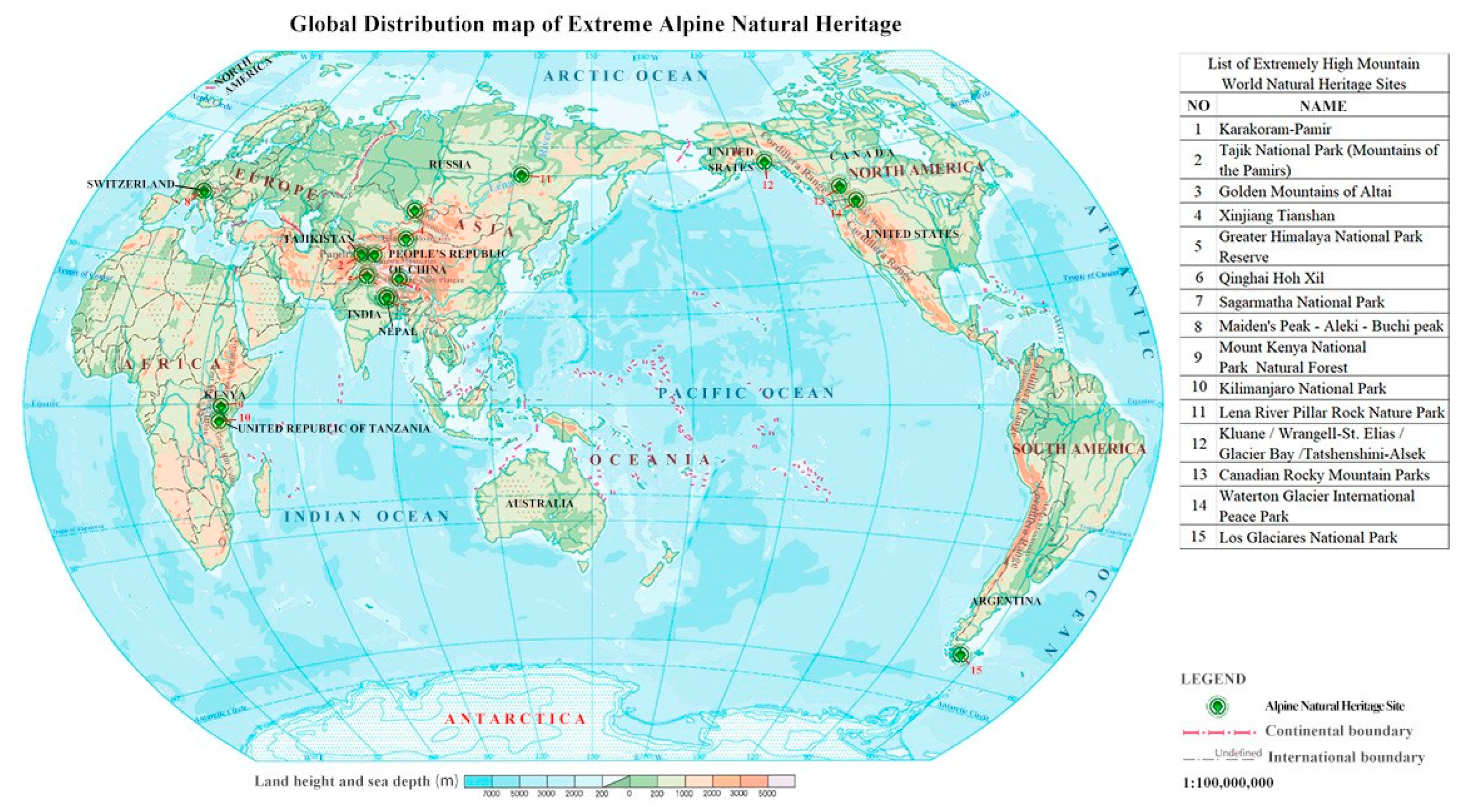
From the perspective of natural heritage, the Karakoram-Pamir peaks are a large mountain heritage, and the small mountain heritage listed in the World Heritage List is not comparable. Compared to the great mountain heritage of America, Europe, and Africa, it belongs to different biogeographic provinces. The Karakoram-Pamir peaks are located in the temperate arid wilderness in the heart of Eurasia. The mountains located in the frigid, subtropical, and tropical regions are quite different from the Karakoram-Pamir Mountains in terms of their integrated physical geography, biodiversity, ecosystem, and natural landscape. The Himalayas also belong to different biogeographic provinces, and the Tianshan Mountains belong to different areas of the same biogeographic province, which cannot be replaced by each other. This paper argues that the Karakoram-Pamir peaks can be listed as a World Heritage site based on criteria VII, VIII, and X; mountain heritages listed under other criteria are not comparable. After screening, 14 large mountain heritages can be compared with the Karakoram-Pamir group, and the following results rankings were obtained through expert scoring (Table 3, Figure 2).

4.2. Aesthetic Value Comparison

Through the Aesthetic Value Comparison, 12 of the 14 large mountain heritage sites worldwide participating in the comparison met the Aesthetic Value Criteria.
Sagarmatha National Park, Xinjiang Tian Shan, Swiss Alps Jungfrau-Aletsch, Mount Kenya National Park/Natural Forest, Kilimanjaro National Park, Waterton Glacier International Peace Park, Tartini-are river/Klun National Park, Rangel St. Elias National Park, Glacier Bay National Park, Rocky Mountain Park, and Glacier National Park in Argentina share similarities with the Karakorum-Pamir Nominated Landscapes portfolio, all containing alpine and glacial landscapes, but at the same time possessing their own globally unique aesthetic features.
Sagarmatha National Park is home to the world’s highest mountain, Mount Sagarmatha (Everest) (8848 m), with a natural landscape of spectacular mountains, glaciers, deep valleys, and majestic peaks. Xinjiang Tianshan is the most extensive mountain range in the temperate arid regions of the world and the largest freestanding mountain chain in the world, east and west. Xinjiang Tianshan is beautiful not only because of its spectacular snow and ice peaks, beautiful forests and meadows, clear rivers [15] and lakes, and red bed canyons, but also because of the combination and contrast of mountain elements with vast deserts. Xinjiang Tianshan is a series of heritages consisting of snow-capped mountains, ice-covered peaks, forests, meadows, rivers and lakes, red-tiered canyons, and deserts in a contrasting landscape. Waterton Glacier International Peace Park is a magnificent natural landscape in an area that has the watershed divide of three of the world’s oceans; the park includes the headwaters of three marine systems, the Hudson Bay, the Gulf of Mexico, and the Pacific Ocean. Pleistocene glaciers formed trumpet-shaped peaks, broad U-shaped valleys, overhanging valleys, estuaries, glacial lakes, streams, and rivers. The Jungfrau-Aletsch-Bietschhorn region is the most glaciated area in the Alps and incorporates the Great Aletsch glacier, the largest and longest in western Eurasia, and a range of classic glacial features such as U-shaped valleys, cirques, horn peaks, and moraines. It is a spectacular view of the northern mountain screen of the Alpine Highlands, centered on the Eiger, Mönche, and Jungfrau, with magnificent peaks and valleys of the Alps and the two great glaciers that develop on them to the south. Kluane/Wrangell-St. Elias/Glacier Bay/Tatshenshini-Alsek and Glacier Bay National Park include excellent natural scenery and unique natural beauty areas, which include the world’s largest nonpolar glaciated area, more than 350 valley glaciers, and approximately 31 surge glaciers. The Canadian Rockies Park contains the largest national park complex in the biogeographic province of the North American Rockies, a very rugged, mostly untouched-by-man, mountainous region with many peaks over 4000 m and local terrain up to 2135 m high, with heritage sites featuring contrasting landscapes of peaks, ice fields, glaciers, alpine meadows, lakes, waterfalls, and cave formations. Argentina’s Glacier National Park is dominated by a combination of glaciers, mountains, and lake landscapes, with 47 glaciers originating from the Patagonian Icefield, dominated by rugged granite peaks, and over 3000 miles of outstanding natural beauty, peaks, and glacial lakes, including the 160 km long Lake Argentina.
Karakoram Mountains, located in the southeast of Pamir and northwest of Qinghai-Tibet Plateau, between China and Pakistan and Indian Kashmir, is the second highest mountain range in the world after the Himalayas [16]. It is composed of mountainous areas extending from northwest to southeast of Doolin, with a total length of more than 700 km and a width of about 100 km. The Karakoram is a typical deep extreme mountain with a relative height variation of 3000–5000 m. The average elevation of the main ridge is 6500 m. Chogori (K2) is the main peak, with an altitude of 8611 m, the second highest peak in the world. There are 4 nearby peaks above 8000 m, and 29 peaks above 7000 m. Pamir Main Peak area is located in the West Kunlun Mountains [17] on the eastern edge of the Pamir Plateau. It is composed of Mount Kongur, Mount Muztag Ata, and the surrounding peaks, intermountain valleys, alpine lakes, etc. It is the highest peak gathering area of the entire Pamir Plateau, among which Kongur Peak, Kongur Tobe Peak, and Muztag Ata peak [18] are the highest peaks in Pamir Plateau, with the altitudes of 7719 m, 7530 m, and 7546 m, respectively [19]. Pamir was formed under the action of tectonic plates. A period of 60 million to 20 million years ago, under the push and compression of the Indian plate toward the Eurasian plate, several large mountain ranges have been successively raised in the Qinghai-Tibet Plateau from north to south, forming the world’s largest mountain junction in the Pamir Plateau, similar to radiation from the center in all directions, at an altitude of 4000 m, the so-called “backbone of the world”. The Karakoram has 2991 glaciers with an area of 6295.19 km2, and 1530 Pamir glaciers with an area of 2361.4 km2 [20]. Modern mountain glaciers in this region are intensively developed, of various types and on a large scale. There are altogether 8 glaciers in the world with a mid-latitude exceeding 50 km, 6 of which are distributed in the Karakoram Mountains. The Karakoram-Pamir Group is the main peak area of the Karakoram and Pamir plateau. It is also the glaciation center of the region, accounting for 36% and 48% of the two mountains, respectively.
Qinghai Hoh Xi and Tajik National Parks (Pamir Mountains) are linked to the Karakorum-Pamir nominated area but have a different landscape type. Qinghai Hoh Xil is located in the northeast corner of the vast Qinghai-Tibetan Plateau, the largest, highest, yet youngest plateau in the world. The lake basins comprise flat, open terrain incorporating the best-preserved planation surface on the Qinghai-Tibet Plateau as well as an unparalleled concentration of lakes. The lakes display a full spectrum of succession stages, forming an important catchment at the source of the Yangtze River and a spectacular landscape dominated by water bodies. Tajik National Park is dominated by alpine wilderness landscapes, and the Karakorum-Pamir is dominated by very high mountain peaks with mega mountain glaciers. Tajik National Park is one of the most extensive alpine reserves in the ancient northern boundary. The Fedchenko glacier, Eurasia’s largest valley glacier and the world’s longest outside the Polar Regions, is unique on a global scale and a spectacular example.
Africa’s Mount Kenya and Mount Kilimanjaro are both volcanic unlike the types of mountains found in the Karakorum-Pamir region. The Kenya National Park/Natural Forest is remarkable due to its glacier-covered peaks and forested mid-slopes. Mount Kenya is the second highest mountain in Africa. The mountain has been deeply cut by glacial erosion. There are twelve remaining glaciers on the mountain, all of which are rapidly retreating, as well as four secondary peaks atop U-shaped glacial valleys. Kilimanjaro is one of the world’s largest volcanoes, consisting mainly of the Kibo, Mawenzi, and Hira volcanoes. Its landscape includes volcanoes, glaciers, Africa’s highest peak, and the surrounding isolated plains. From the lowest to the highest point, the mountain has five distinct vegetation zones: lower slopes, montane forest, subalpine forest, alpine forest, wilderness and high marshland, high desert, and mountain tops. The main landscapes include mountain forests, moorland, upland bogs, alpine bogs, and alpine deserts.
The landscape combination of Kongur Mountain in the Pamir Plateau and the surrounding peaks contributes to the Geological Gallery of the Karakoram-Pamir heritage potential area. The Karakorum-Pamir group of peaks is the largest mountain knot in the world, and K2 (Chogori peak) is the second highest peak in the world. Inter-valley land, alpine lakes, glacier landforms, and snow peaks form a typical landscape. Within the region, Insukati Glacier is the largest glacier in China, with a length of 42 km and an area of 379.97 km2 [21], which is the unique combination of a mountain landscape in the Karakoram-Pamir heritage potential area. Typical and unique types of mountain glaciers such as ice cap glaciers, through glaciers, ice sheets, and overflow glaciers have developed in the region on the Insukati glacier. Typical unique mountain glacier types are developed in the Karakoram-Pamir group, such as ice cap glaciers, penetrating glaciers, ice fields, and overflowing glaciers [13].

4.3. Comparison of Geological Values

Of the 14 large mountain heritage sites worldwide that were compared, 8 World Natural Heritage sites met the geological value criteria, including Tajik National Park (Mountains of the Pamirs, Lena Pillars Nature Park, Swiss Alps Jungfrau-Aletsch, Kluane/Wrangell-St. Elias/Glacier Bay/Tatshenshini-Alsek, Rocky Mountain Parks, and Glacier National Park). These heritage sites differ markedly from the Karakorum-Pamir nominated sites in terms of geological formation and geological age.
The Karakorum-Pamir nominated land is world famous for its mountain junctions. Pamir was formed under the action of tectonic plates. Before 60 million to 20 million years, under the push and compression of the Indian plate toward the Eurasian plate, several large mountain ranges have been successively raised in the Qinghai-Tibet Plateau from north to south, forming the world’s largest mountain junction in the Pamir Plateau. In this region, there is a plate tectonic suture zone of collision between the Indian Ocean plate and the Eurasian plate, which is the result of the extinction and closure of the Gutethys Ocean, and also an important tectonic turning point. Several tectonic boundaries converge here, among which the Mazha Kangshiwa fault zone [22] is the most important tectonic suture zone.
The Karakorum-Pamir nominated area is an important area for the distribution of very high mountain glaciers in the world. The region is one of the key areas of the undisturbed global distribution of modern glaciers, complete in type and magnitude, and typical of the very high mountainous mountain glaciers of the Asian and European hinterland. The Karakoram-Pamir Group is the main peak area of the Karakoram and Pamir plateau. It is also the glaciation center of the region, accounting for 36% and 48% of the two mountains, respectively.
The Karakorum-Pamir nomination is the most representative area of the Tethys tectonic domain. Karakoram-Pamir peaks have experienced the structural evolution history of polycycles, retaining the history of opening and closing of the intercontinental limited ocean basins in the early Paleozoic on the southern margin of the Asian continent, and rock and stratigraphic history of the late Paleozoic Paleo Tethys Ocean tension and subduction closure [23]. It also clearly shows the tectonic features of subduction, collision closure, and squeeze slip of the New Tethys Ocean between the Indian plate and the Asian plate [24]. The anatomy of the depositional and tectonic evolution pattern in this area reveals the collage process characteristics of the Eurasian continent and the Qiangtang block, which is the key area to study the formation and evolution of the East Tethys Sea and the mechanism of plate collision.
In contrast, the geological formations represented by the Tajik National Park (Pamir Mountains), the Canadian Rocky Mountains Park, and the Karakorum-Pamir nominated land are different. Lake Sares is of great international scientific and geological significance. Due to the ongoing geological processes affecting its stability and the type of lacustrine ecosystem that will develop over time, this area is of international scientific and geomorphological significance. The Burgess Shale in the Canadian Rockies Park is one of the most important fossiliferous areas in the world, testifying to the evolutionary history of the Earth, with geological formations consisting of highly fractured, folded, and uplifted sedimentary rocks. In contrast, the Karakorum-Pamir nomination is the most representative region of the Tethys tectonic domain, the result of the extinction and closure of the ancient Tethys Ocean, and a concentration of large mountain junctions, pole peaks, and glaciers.
The Lena Pillars Nature Park, the Swiss Alps Jungfrau-Aletsch, and the Argentine Glacier National Park are of a different geological age compared to the Karakorum-Pamir nominated land. The Lena Pillars Nature Park contains a large number of Cambrian fossil remains. The Swiss Alps Jungfrau-Aletsch records the Alpine orogeny of 20–40 million years ago, and the principal sediments of this area are the lower- to lower-middle-Cambrian richly fossiliferous continuous carbonates of various marine genesis. These strata characterize the Fortunian Stage, Stage 2 (Terreneuvian Series), Stages 3 and 4 (Series 2), and Stage 5 (Series 3) of the International Stratigraphic Chart issued by the International Commission on Stratigraphy (2008) and, thus, embraces an interval of, c., 542–506 Ma. Those are the rocks that build the Lena Pillars as well as the Buotama Pillars themselves. The Swiss Alps Jungfrau-Aletsch records the Alpine orogeny of 20–40 million years ago. The Argentine Glacier National Park is a good example of the important glacial processes and geological, geomorphological, and topographical phenomena resulting from the continued advance and retreat of glaciers during the Quaternary Pleistocene and the new ice age corresponding to the current or Holocene. The Karakorum-Pamir nomination is an excellent illustration of crustal evolution and environmental change since the Middle Cenozoic.
Kluane/Wrangell-St. Elias/Glacier Bay/Tatshenshini-Alsek and the Karakorum-Pamir Nominated Land both represent the development and change processes of glacial landforms, but with different numbers and types of glaciers. Glacier Bay National Park contains the world’s largest nonpolar glacier coverage area with more than 350 valley glaciers and about 31 surge-type glaciers. The impact of glaciers at the landscape level has also led to extensive stages of ecological succession associated with the dynamic movement of glaciers. This region is the most seismically active in North America, and it is one of the few places on the planet where natural pressures and evolutionary changes in the glacial and ecological continuum govern ecological processes. Karakorum Mountain has 3454 glaciers and 1530 Pamir glaciers, the nominated area contains a variety of glacier types, including ice cap glaciers, through glaciers, ice sheets, and overflow glaciers, and there are significantly more glaciers and glacier types than in Glacier Bay National Park.

4.4. Comparison of Bioecological Values

By comparing the bioecological values, seven of the 14 mountain-based natural heritage sites worldwide that participated in the comparison met the bioecological value, i.e., highlighting the universal value (X), including Qinghai Hoh Xil, Greater Himalaya National Park Reserve, Golden Mountains of Altai, Kluane/Wrangell-St. Elias/Glacier Bay/Tatshenshini-Alsek, and Glacier National Park. By way of comparison, these seven World Natural Heritage sites differ significantly from the Karakorum-Pamir nominated sites in terms of their bioecological value.
The heritage site has different endemic species compared to the Qinghai Hoh Xil. The Qinghai Hoh Xil has ensured that there is a complete migration route between Sanjiangyuan and Hexi for antelope and has allowed for the unhindered migration of Tibetan antelope, which is one of the endangered large mammals that is only found on the plateau. More than a third of the higher plants that can be found in the area are endemic to the plateau, as are all of the herbivores that feed on these plants because they are the only ones that can survive on the plateau. The habitats and natural processes that Tibetan antelopes go through throughout their life cycle are protected by the heritage site. The study area is located in the Pamir-Tianshan mountain biogeographic province in the Udvardy biogeographical regionalization. The migration and fusion of biota in this region are relatively complex. It belongs to the plateau faunal region of the intersection of Karakoram and Pamir in the Himalayas, occupying a unique seat in the global alpine regions. The natural landscape has obvious vertical zonal differences and east–west differences. The base zone belongs to the desert zone, and the surface is mainly bare stony desert and moraine. A spiny cushion plant community is distributed at 3200–3600 m; the original area of Lemuria and Needle weed is distributed at 3600–3800 m; Alpine desert plants are developed at 3800–4300 m; the alpine permanent snow belt is above 4300 m [25]. The Pamir Plateau is home to 54 families, 274 genera, and 846 species of seed plants, the representative genera of which are mainly Acanthopanax, Cotyledon, Artemisia, Balinese, Chamomile, Dandelion, and carpetgrass [26]. Within the Karakoram-Pamir heritage potential area, there is the Tashkurgan Nature Reserve, an important habitat for numerous endangered and endemic species, including rare wild animals such as the snow leopard [27], Marco Polo Argyra, brown bear, wolf, and wild yak in the IUCN Red List. The snow leopard and the argali have been listed as endangered species internationally, and the brown bear is a second-class national-protected animal. There is also a long-tail early otter, grass rabbit, fox, and snow chicken distribution. The snow leopard and the argali have been listed as endangered species internationally, and the brown bear is the second class national protected animal [28].
The Greater Himalaya National Park is located in the globally important Temperate Forest Ecosystem of the West Himalaya. The protected area is also included in Conservation International’s “Biodiversity Hotspot” in the Himalayas and BirdLife International’s Western Himalayan Endemic Bird Area. There are 805 species of vascular plants, 192 species of lichens, 12 species of liverworts, and 25 species of mosses in the Greater Himalayas National Park. Approximately 58% of angiosperms are exclusive to the Western Himalayas. The two heritage sites are located in different ecological zones compared to each other. Karakorum-Pamir is located in the “Central Asian Mountain Temperate Steppe” ecological zone, while the Great Himalayan National Park Reserve is situated in the “Temperate Forest of the Western Himalayas” Ecological zone. The species protected are different.
The Altai region is an important area and center of origin for the diversity of plant and animal species, with plants and animals known for their remnants and endemism, containing more than 2000 species of flora, 60 different mammals, 11 species of reptiles and amphibians, and 20 species of fish. For example, the area represents the most complete sequence of vertical vegetation zones in central Siberia, ranging from the steppe, forest-steppe, mixed forest, and subalpine vegetation to alpine vegetation, and is also an important habitat for endangered animals such as the snow leopard. The geographical ecological zone in which they are located is different; the Jinshan-Altai Mountains is the main mountain range of the West Siberian geographical ecological zone, and the Karakorum-Pamir nominated land belongs to the Tibetan Plateau ecological zone and Karakorum Mountains gravel desert ecological zone [29].
Wrangell-St. Elias/Glacier Bay/Tatshenshini-Alsek and Glacier National Park are some of the few places where natural pressures and alterations in the glacial and ecological continuum are brought about by evolutionary processes, which are governing ecological processes. Karakorum-Pamir is the highland fauna of the Himalayan Karakorum and Pamir convergence zone, and the two are not comparable in terms of ecological value.

5. Conclusions

The rankings derived from the expert scoring method were validated by a global comparative study. The project team concluded that for large mountain natural heritage sites, the aesthetic value of having a landscape that is unique in the world is more easily judged than unparalleled beauty; for geological value, the geological type, age, uniqueness, and representativeness of the geomorphological type of glacier that is unique to large mountain heritage sites is the basis for judgment. For bio-ecological values, geographic location within Global Biodiversity 200, mountain heritage sites located in Global Biodiversity Conservation Priority Areas, Global Biodiversity Conservation Hotspots, or Priority Areas are more advantageous, and heritage sites are judged more on the presence of IUCN Red List endangered flora and fauna or endemic species. The model of the comparison of values of large mountain World Natural Heritage sites is feasible and can provide a model and experience for comparison and judgment of mountain-based heritage nominations at a later stage.
Compared with these 14 large mountain heritages, the Karakoram-Pamir peaks are the only mountain junction where the five major mountain systems meet. The Pamir tectonic junction is the region where the Indian Ocean plate inserted into the Eurasian plate and collided with the Tarim plate and the Kazakhstan plate with the most violent collision, the closest remote effect, and the most prominent uplift of mountains. It is also the region with the strongest uplift of plate collision in the past 5 million years, which is unique in the world.
The Karakorum-Pamir group of peaks resides in the temperate arid wilderness zone of Asia’s hinterland and Europe. The mountains in the cold, subtropical, and tropical zones are very different in terms of their integrated physiographic features, biodiversity, ecosystems, and natural landscapes, and are not comparable to the Karakorum-Pamir group of peaks, compared to the large mountain heritage of America, Europe, and Africa. It also belongs to a different biogeographic province from the mega-mountain system, the Himalayas, and a different part of the same biogeographic province as the Tian Shan, and it is not interchangeable with each other.
Through comprehensive analysis and Expert Scoring Method, the natural heritage characteristics and values of the Karakoram-Pamir heritage potential area were analyzed and a global comparative study was carried out. It was concluded that the natural heritage area met criteria VII, VIII, and XI of the criteria of World Natural Heritage [30].
Criteria VII: Pamir is the highest mountain junction in the world, while Georgy is the second highest peak group in the world. The Pamir Plateau, including Kongur Peak, Kongur Jipe Peak, and Mustag Peak, forms the third highest peak group in the world, showing the rare natural beauty of the combination of extremely high peaks and mountain glaciers in the world.
Criteria VIII: The Karakoram-Pamir region represents the evolution of the supercontinent and the ocean-land pattern of ancient Asia. It is a prominent example of a crucial stage in the evolutionary history of the Earth and provides evidence for a series of major events in the Earth’s history, such as the Meso-Cenozoic orogeny and the nontectonic movement.
Criteria X: The Pamir-Tianshan Mountain Biogeography province in the Udvardy biogeography division is a key area of central Asian mountain temperate forests and grasslands in the central Asian mountain temperate forests and grasslands in the 34 biodiversity hotspots worldwide by the International Conservation Organization (CI) and the WWF’s global 200 biodiversity Priority Protection key area. Habitats of endangered species of snow leopard and Marco Polo Argali are with outstanding universal value [31].
Therefore, based on the value analysis of historical culture, geology, aesthetics, and biological ecology, the Karakoram-Pamir area of Xinjiang has the outstanding universal value of world heritage and the potential to declare world natural and cultural heritage.

6. Discussion

This paper summarizes the World Natural Heritage values and evaluation models of the Karakorum-Pamir Potential Area, demonstrating that it has outstanding universal value as a World Natural Heritage site. However, a review of the cultural heritage values of the Karakorum-Pamir Potential Area and a global comparative study are also important in terms of the integrity of heritage values. The Karakorum-Pamir Potential Area is not only of outstanding universal value as a natural heritage site but also of unique cultural heritage value, as the southern and central routes of the ancient Silk Road converge at Karakorum-Pamir, which was a major transportation hub along the ancient Silk Road. In addition, Xinjiang has been a multi-ethnic region since ancient times, and its historical background is unique, so the selection of objects for global comparison needs to be considered repeatedly. Due to the above factors and space considerations, the author has included the cultural heritage values of the Karakorum-Pamir potential area in a subsequent paper, to make the comparison of values more complete and comprehensive.
The process of this paper is qualitative and attempts to include quantitative analysis have been made but were difficult. However, in terms of the thesis itself, the empirical fieldwork, expert scoring, and international comparisons are currently available as a more scientific approach to global comparisons, and the project team believes that this assessment model and the process can be applied to other large mountain heritage sites, providing lessons that can be used for global comparisons of heritage. The possibility of including quantitative analysis is to be explored.

Author Contributions

Writing—original draft, R.X.; funding acquisition, R.X.; writing—review and editing, Z.Y.; methodology, X.X.; software, R.X.; data acquisition, R.X.; supervision, Z.Y. All authors have read and agreed to the published version of the manuscript.

Funding

This research was funded by Major Special Projects in Xinjiang Uygur Autonomous Region (No. 2022A03002-2). West Light Foundation of The Chinese Academy of Sciences (2019-XBQNXZ-A-007).

Institutional Review Board Statement

Not applicable.

Informed Consent Statement

Not applicable.

Data Availability Statement

Not applicable.

Conflicts of Interest

The authors declare no conflict of interest.

References

  1. UNESCO. Convention Concerning the Protection of the World Cultural and Natural Heritage; CENTRE WH: Paris, France, 1972. [Google Scholar]
  2. Wei, X.C.Z.; Chen, Z. Natural Reserve System in China from a Perspective of World Natural Heritage. J. West China For. Sci. 2021, 50, 180–184. [Google Scholar]
  3. UNESCO. Operational Guidelines for the Implementation of the World Heritage Convention; CENTRE WH: Paris, France, 2019. [Google Scholar]
  4. Cunha, S.F. Perestroika to Parkland: The Evolution of Land Protection in the Pamir Mountains of Tajikistan. Ann. Assoc. Am. Geogr. 2017, 107, 465–479. [Google Scholar] [CrossRef]
  5. Yu, H.; Deng, W.; Jia, J. Research on the Resources, Value and Protection of Qinghai Hoh Xil World Heritage Site. Chin. Landsc. Archit. 2018, 34, 106–111. [Google Scholar]
  6. Kim, S.J. Geographical and Environmental Features of the Canadian Rockies(Skyline, Lake O’Hara and Robson). J. Assoc. Korean Photo-Geogr. 2016, 26, 1–13. [Google Scholar]
  7. Yang, Z.; Zhang, X.; Di, F.; Wall, G.; Liu, X.; Shao, R. Natural heritage values and comparative analyses of Kanas, China. J. Arid Land 2010, 2, 197–206. [Google Scholar]
  8. Yang, S.; Jiang, J.; Yan, P. Eco-geographic distribution of rare and endangered plants and endemism in the Pamirs Region of China. J. Arid Land Resour. Environ. 2018, 32, 115–120. [Google Scholar]
  9. Centre, W.H. Karakorum-Pamir. Available online: http://whc.unesco.org/en/tentativelists/5535/ (accessed on 8 August 2021).
  10. Guodong, L. Tashkurgan Wildlife Reserve was established. For. Xinjiang 1984, 5, 26. [Google Scholar]
  11. Cheng, Q. Survey and Analysis of Wild Animal Resources in Xinjiang Taxkorgan Wildlife Nature Reserve. For. Resour. Manag. 2021, 3, 145–148. [Google Scholar]
  12. National Forestry and Grassland Administration, National Park Administration. Pamir Plateau Wetland Nature Reserve: Green Dress Beautiful Plateau. Available online: http://www.forestry.gov.cn/main/5536/20190705/171816754515616.html (accessed on 6 July 2021).
  13. Shangguan, D.H.; Liu, S.Y.; Ding, Y.J.; Ding, L.F.; Shen, Y.P.; Zhang, S.Q.; Lu, A.X.; Li, G.; Cai, D.H.; Zhang, Y. Monitoring Glacier Changes and Inventory of Glaciers in Muztag Ata-Kongur Tagh, East Pamir, China Using ASTER Data. J. Glaciol. Geocryol. 2005, 3, 344–351. [Google Scholar]
  14. International Union for Conservation of Nature, Red List of Threatened Species. Available online: https://www.iucnredlist.org/ (accessed on 6 July 2021).
  15. Wang, Z.; Yang, Z.; Shi, H.; Han, F.; Liu, Q.; Qi, J.; Lu, Y. Ecosystem Health Assessment of World Natural Heritage Sites Based on Remote Sensing and Field Sampling Verification: Bayanbulak as Case Study. Sustainability 2020, 12, 2610. [Google Scholar] [CrossRef] [Green Version]
  16. Agrawal, S.; Jain, A. Physical Modelling of Nanda Devi National Park, a Natural World Heritage Site, from GIS Data. Cartographica 2022, 57, 179–190. [Google Scholar] [CrossRef]
  17. Zhang, Q. Uplift and Environmental Changes of the Tibetan Plateau. Geoj. Libr. 2000, 57, 19–45. [Google Scholar]
  18. Yeong Bae Seong Lao, C.Y.; Robert, C. Finkel, Lindsay Schoenbohm., Dynamic Change of Landscape Spatial Pattern in Karakul Lake Region in Xinjiang. Chin. Agric. Sci. Bull. 2009, 103, 227–250. [Google Scholar]
  19. Kuerban, A.; Chu, X.; Aimaiti, Y. Dynamic Change of Landscape Spatial Pattern in Karakul Lake Region in Xinjiang. Chin. Agric. Sci. Bull. 2016, 32, 78–84. [Google Scholar]
  20. Liu Zongxiang, S.Z. Resources and Distribution of Glaciers on the Tibetan Plateau. Resour. Sci. 2000, 5, 49–52. [Google Scholar]
  21. ZhangXiangsong, Recent variations of the Insukati Glacier and adjacent glaciers in the Karakoram Mountains. J. Glaciol. Geocryol. 1980, 3, 12–16.
  22. Jianping, W. Geological features and tectonic significance of melange zone in the Taxkorgan area, West Kunlun. Geol. Bull. China 2008, 27, 2057–2066. [Google Scholar]
  23. Jiang Yaohui, R.G. New advances in granite research in the West Kunlun orogenic belt. Volcanol. Miner. Resour. 2000, 1, 61. [Google Scholar]
  24. Ding Daogui, L.Y. Collision structures in Pamir region and reformation of Tarim Basin. Oil Gas Geol. 2005, 26, 57–63, 77. [Google Scholar]
  25. Huang Dawei, L.Y. The Pamir Plateau A rare wonder of the world. In Proceedings of the 28th Annual Meeting of Tourism Geology and Geopark Research Branch of Chinese Geological Society and Seminar on Construction and Tourism Development of Guizhou Weaving Cave National Geopark, Beijing, China, 1 August 2013; p. 8. [Google Scholar]
  26. Liang Na, A.N. Tuerxunnayi Reyimu, Comparative Analysis of Floristic Phytogeography of Seed Plants Between Pamirs Plateau of Xinjiang and Tajikistan. Xinjiang Agric. Sci. 2015, 52, 1906–1916. [Google Scholar]
  27. McCarthy, T.; Breitenmoser, U.; Breitenmoser-Wrsten, C. Another flagship species was pushed to the brink of extinction. People Biosph. 2008, 6, 1. [Google Scholar]
  28. Zuojian, F. On the Status And Conservation of The Wild Animal Resources In The Karakorum-Kunlun Mountains Region, China. J. Nat. Resour. 1990, 4, 343–353. [Google Scholar]
  29. Fu, B.; Liu, G.; Chen, L.; Ma, K.; Li, J. Scheme of ecological regionalization in China. Acta Ecol. Sin. 2001, 21, 1–6. [Google Scholar]
  30. Xu, X.L.; Yang, Z.P.; Saiken, A.; Shao, R.; Liu, X.Y. Natural Heritage value of Xinjiang Tianshan and global comparative analysis. J. Mt. Sci. 2012, 9, 262–273. [Google Scholar] [CrossRef]
  31. Cleere, H. The concept of ‘outstanding universal value’ in the World Heritage Convention. Conserv. Manag. Archaeol. Sites 2013, 1, 227–233. [Google Scholar] [CrossRef]
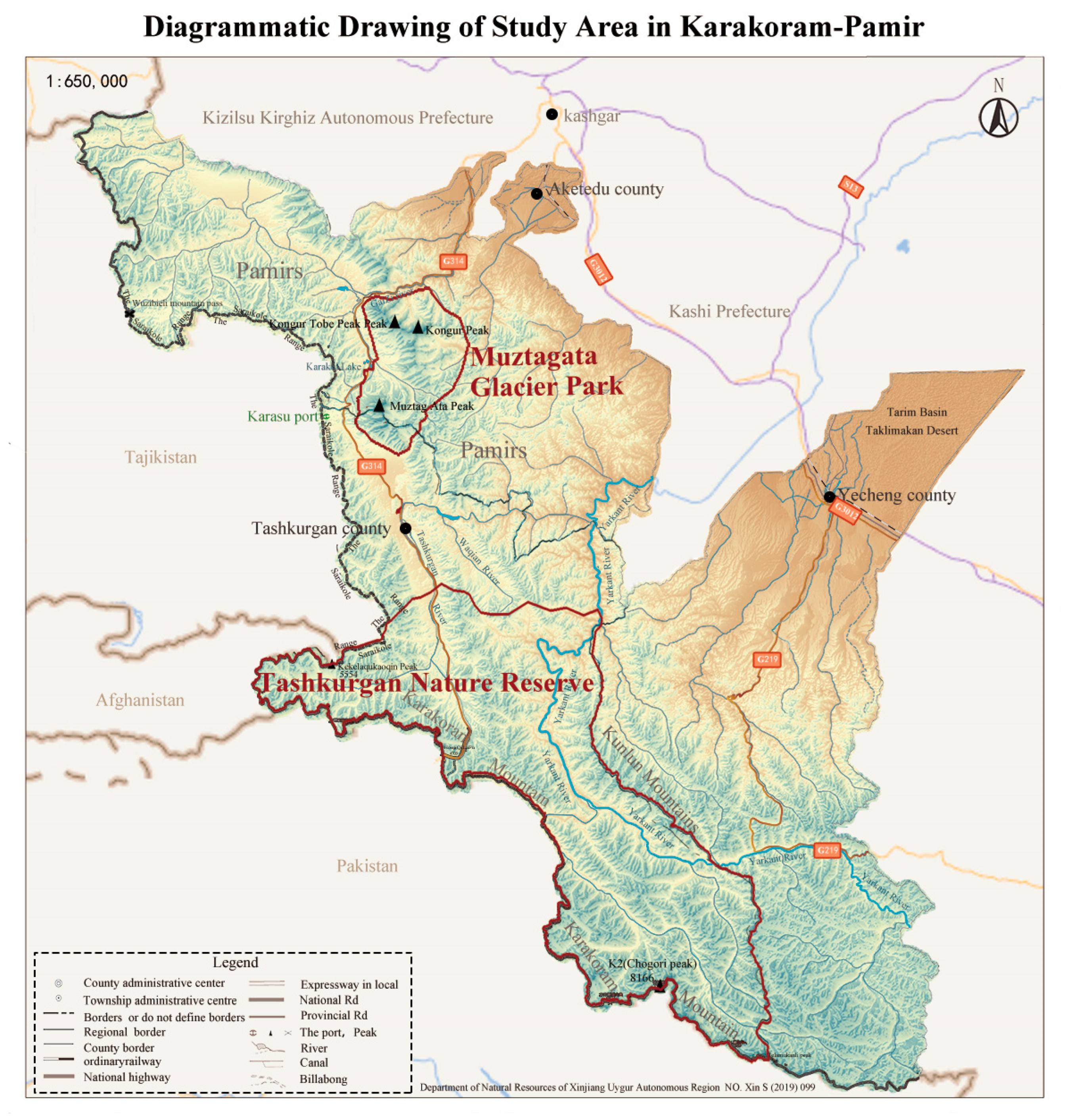
Figure 1. Schematic diagram of the study area.
Sustainability 14 12546 g001
Figure 2. Schematic diagram of world mountain heritage distribution.
Sustainability 14 12546 g002
Table 1. Survey of the research area.
Name of Protected AreaProtection LevelArea (km2)LocationGeographical Coordinates
Tashkurghan Nature ReserveAutonomous region level6192.04Tashkurgan County, Yecheng County74°456′–76°235′ E,
35°592′–37°550′ N
Pamir Wetlands Nature ReserveAutonomous region level2187.86Akto County, Tashkurgan County75°004′–75°570′ E,
38°085′–38°763′ N
Table 2. Large-scale comparative mountain World Natural Heritage values model.
ObjectivesIndicatorsStratification of IndicatorsScoring Instructions
Competitive analysis of the World Natural Heritage of the Very High MountainsValue (VII): encompasses natural phenomena of the highest order or areas of exceptional natural beauty and aesthetic importance;① Availability of the world’s best views, including extreme peaks, knots, and glaciers.The total score of the two indicators is 25; indicator ① is the core indicator and indicator ② is the degree indicator; meeting indicator ① alone will add points, and meeting indicator ② alone will not add points
② Whether the landscape is similar to other very-high-mountain natural heritage landscapes and whether the representation is outstanding
Values (VIII): are outstanding examples representing major phases of the Earth’s history, including the record of life, important ongoing geological processes in the development of the landscape, or significant landforms or geomorphological features;① Are the geotectonic features distinct and prominent?The total score for the three indicators is 25 points, one of which is considered a plus.
② Is the geological age distinct and prominent?
③ Whether the glaciers represented are distinct and prominent in number and type
Values (IX): are outstanding examples representing important ongoing ecological and biological processes in the evolution and development of terrestrial, freshwater, coastal, and marine ecosystems and plant and animal communities;① Whether there is a typical vertical natural zone and whether it is distinct and prominent compared to other mountain rangesThe total number of points for both indicators is 25, of which 1 indicator is considered an extra point.
② Does it represent a prominent case in the evolution of biological ecology?
Value (X): encompasses the most important and significant natural habitats in terms of in situ conservation of biodiversity, including habitats of threatened species that are of outstanding universal value from a scientific or conservation perspective.① Is it in a Global 200 Biodiversity Conservation Priority Ecoregion?The total score for the 4 indicators is 25 points, of which one of the first 3 indicators or the fourth indicator is regarded as extra points.
② Is it in a global biodiversity conservation hotspot?
③ Is it in a global biodiversity conservation priority area?
④ Presence of IUCN Red List endangered plants and animals or endemic species
Table 3. Expert scoring of 14 major mountain heritage items compared to the Karakorum-Pamir group of peaks.
NO.Heritage SiteCountryLongitude and LatitudeCriteria
1Kluane/Wrangell-St. Elias/Glacier Bay/Tatshenshini-AlsekCanada/United StatesN 61°11′51.3″(VII) (VIII) (IX) (X)
W 140°59′31.1″
2Swiss Alps Jungfrau-AletschSwitzerlandN 46°30′0″(VII) (VIII) (IX)
E 8°1′60″
3Karakoram-Pamir ChinaE 74°456′(VII) (VIII) (X)
N 38°763′
4Qinghai Hoh Xil,ChinaN 35°22′49″(VII) (X)
E 92°26′21″
5Xinjiang TianshanChinaN 30°43′0.012″(VII) (IX)
E 79°40′0.012″
6Rocky Mountain ParksCanadaN 51°25′29″(VII) (VIII)
W 116°28′47″
7Glacier National ParkArgentinaN 48°59′45.8″(VII) (VIII)
W 113°54′15″
8Waterton Glacier International Peace ParkCanada/United StatesN 48°59′45.8″(VII) (IX)
W 113°54′15″
9Mount Kenya National Park/Natural ForestKenyaN 0°9′18″ (VII) (IX)
E 37°18′56″
10Tajik National Park (Mountains of the Pamirs)TajikistanN 38°45′54″(VII) (VIII)
E 72°18′19″
11Greater Himalaya National Park ReserveIndiaN 31°49′60″(X)
E 77°34′60″
12Golden Mountains of AltaiChinaN 50°28′0″(X)
E 86°0′0″
13Lena Pillars Nature ParkRussiaN 60°40′0″(VIII)
E 127°0′0″
14Sagarmatha National ParkNepalN 27°57′55.008″(VII)
E 86°54′47.016″
15Kilimanjaro National ParkUnited Republic of TanzaniaS 3°4′0.012″ (VII)
E 37°22′0.012″
Publisher’s Note: MDPI stays neutral with regard to jurisdictional claims in published maps and institutional affiliations.