
Use of Remote-Sensing-Based Global Products for Agricultural Drought Assessment in the Narmada Basin, India


Abstract
:1. Introduction
2. Materials and Methods
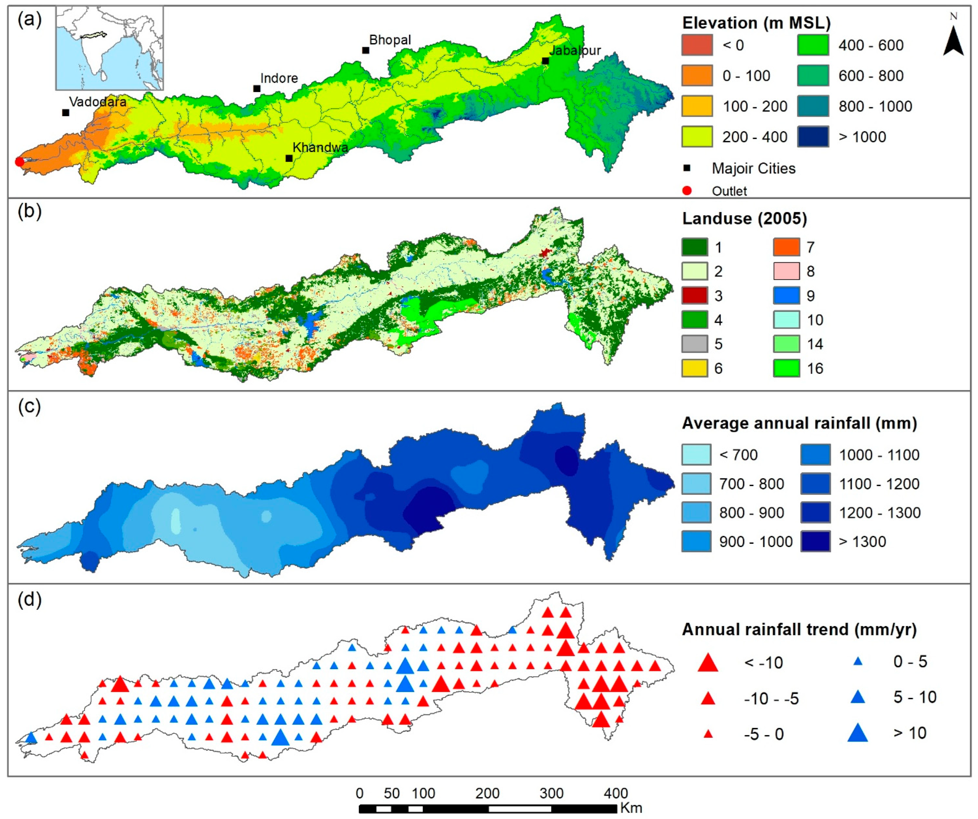
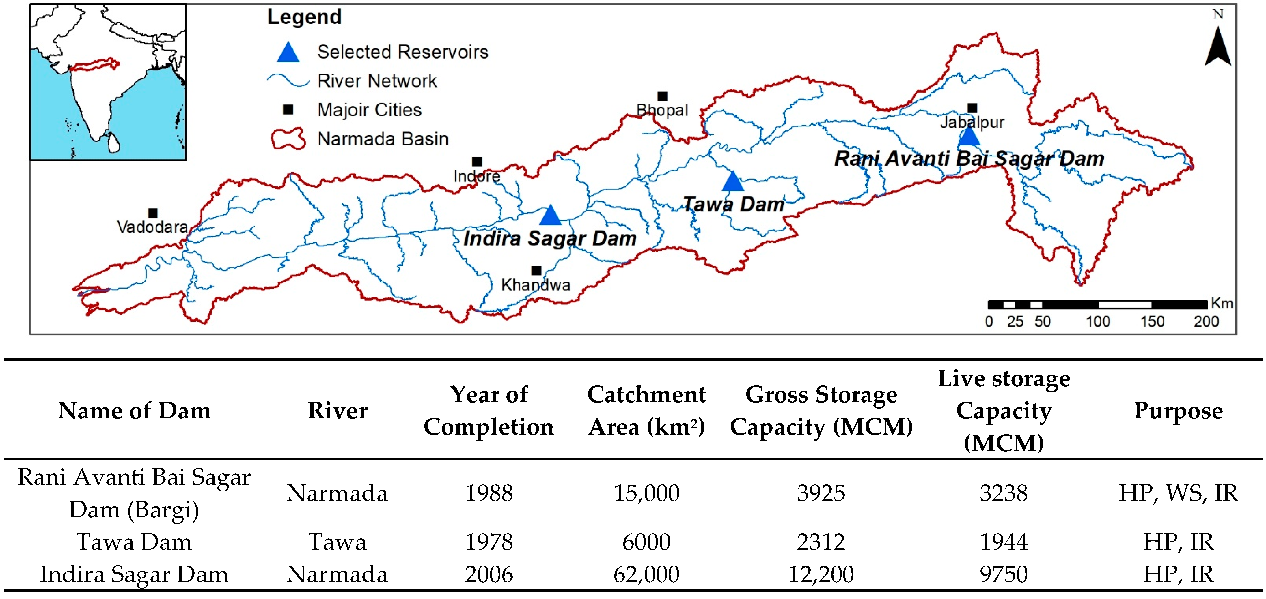
2.1. Study Area
2.2. Data Used
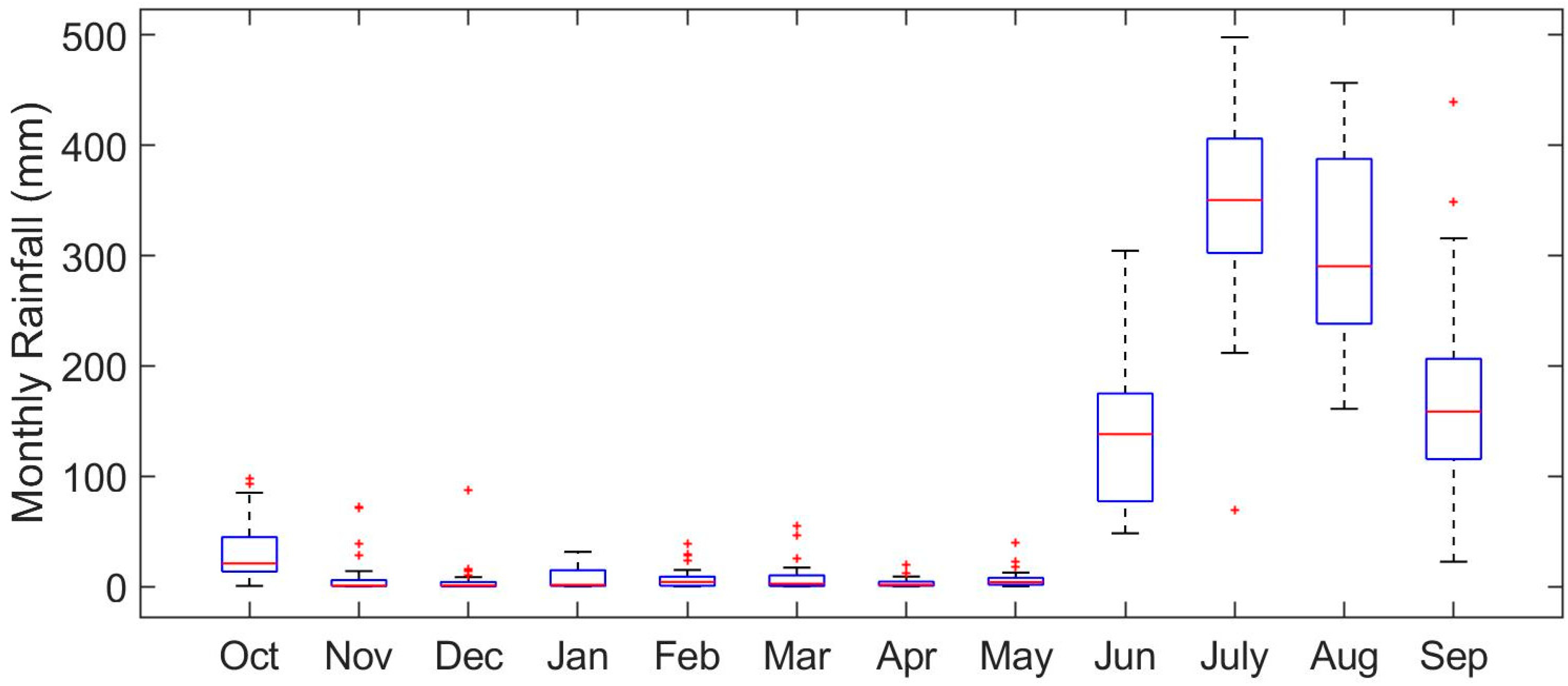
2.2.1. Meteorological Data
2.2.2. Remote-Sensing-Based Global Products
2.2.3. Reservoir Characteristics and Operational Data
2.3. Drought Iindices and Assessment
2.3.1. Indices Derived from Rainfall
2.3.2. Normalized Difference Vegetation Index (NDVI)
2.3.3. Soil Moisture Content
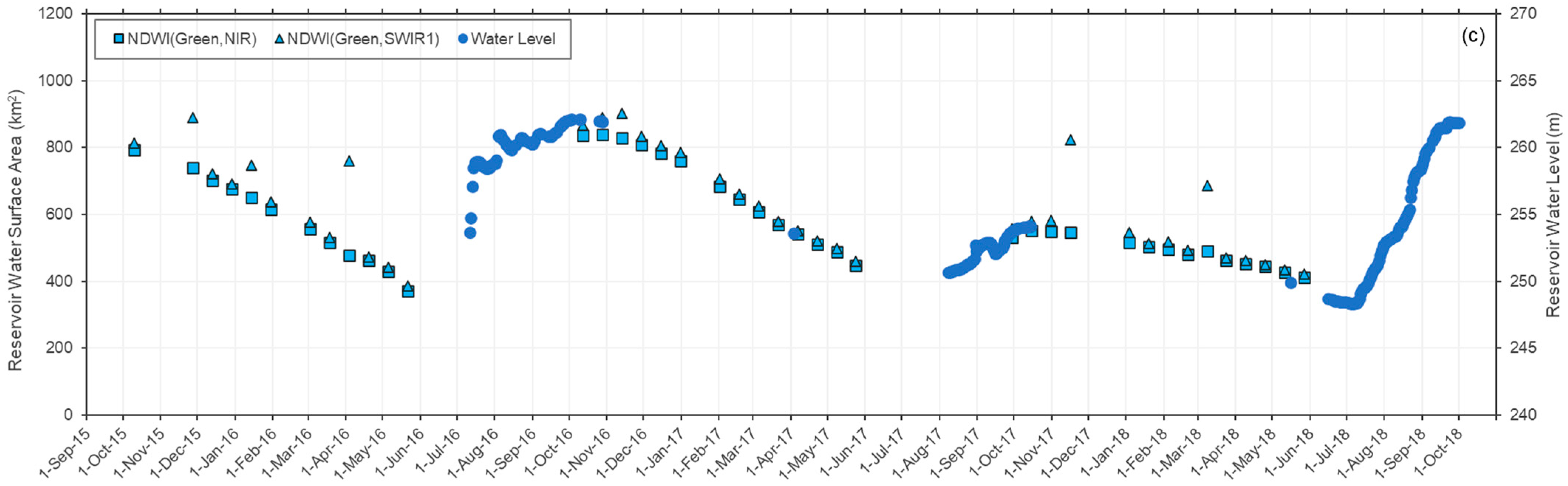
2.3.4. Reservoir Water Surface Area
3. Results and Discussion
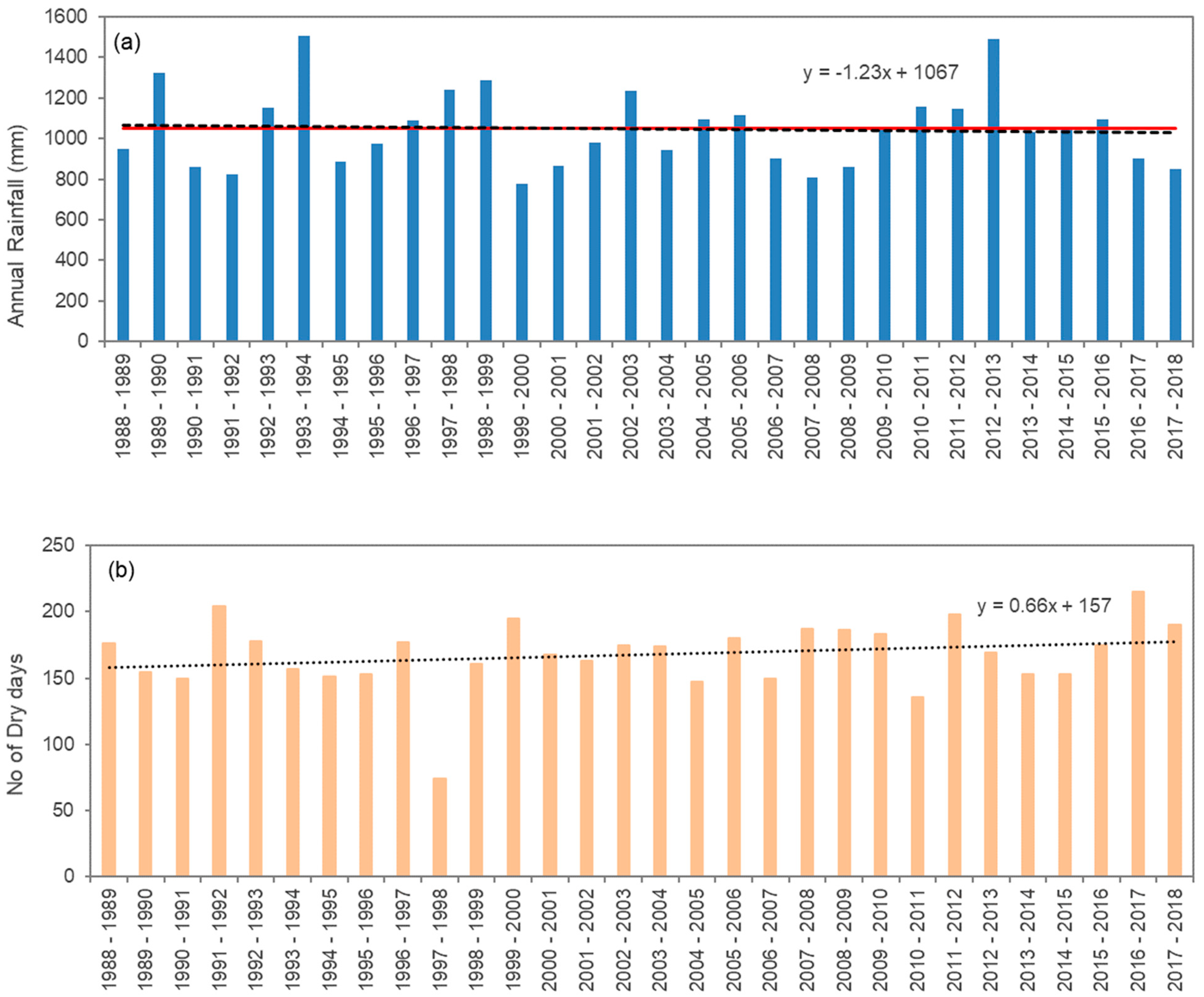
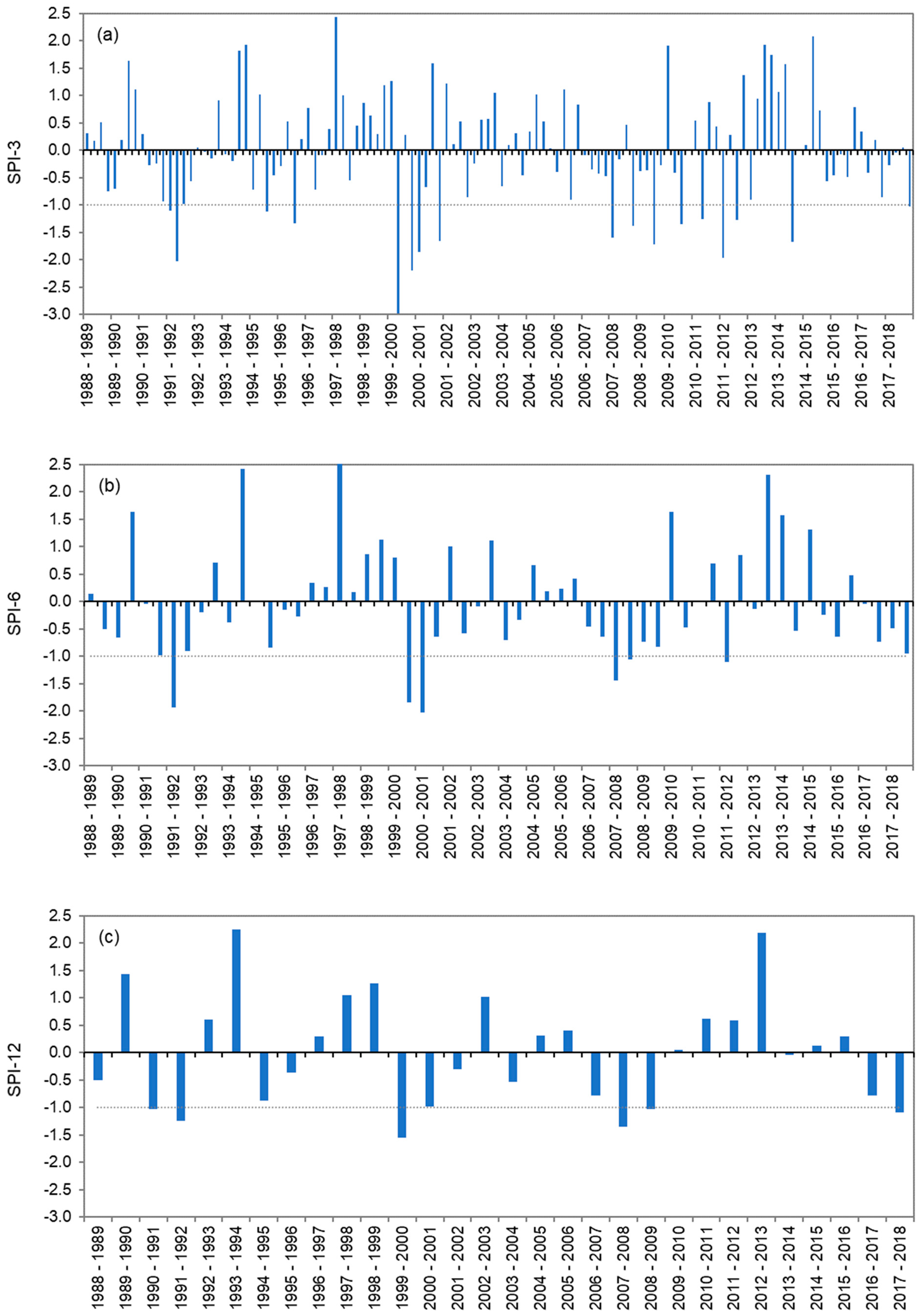
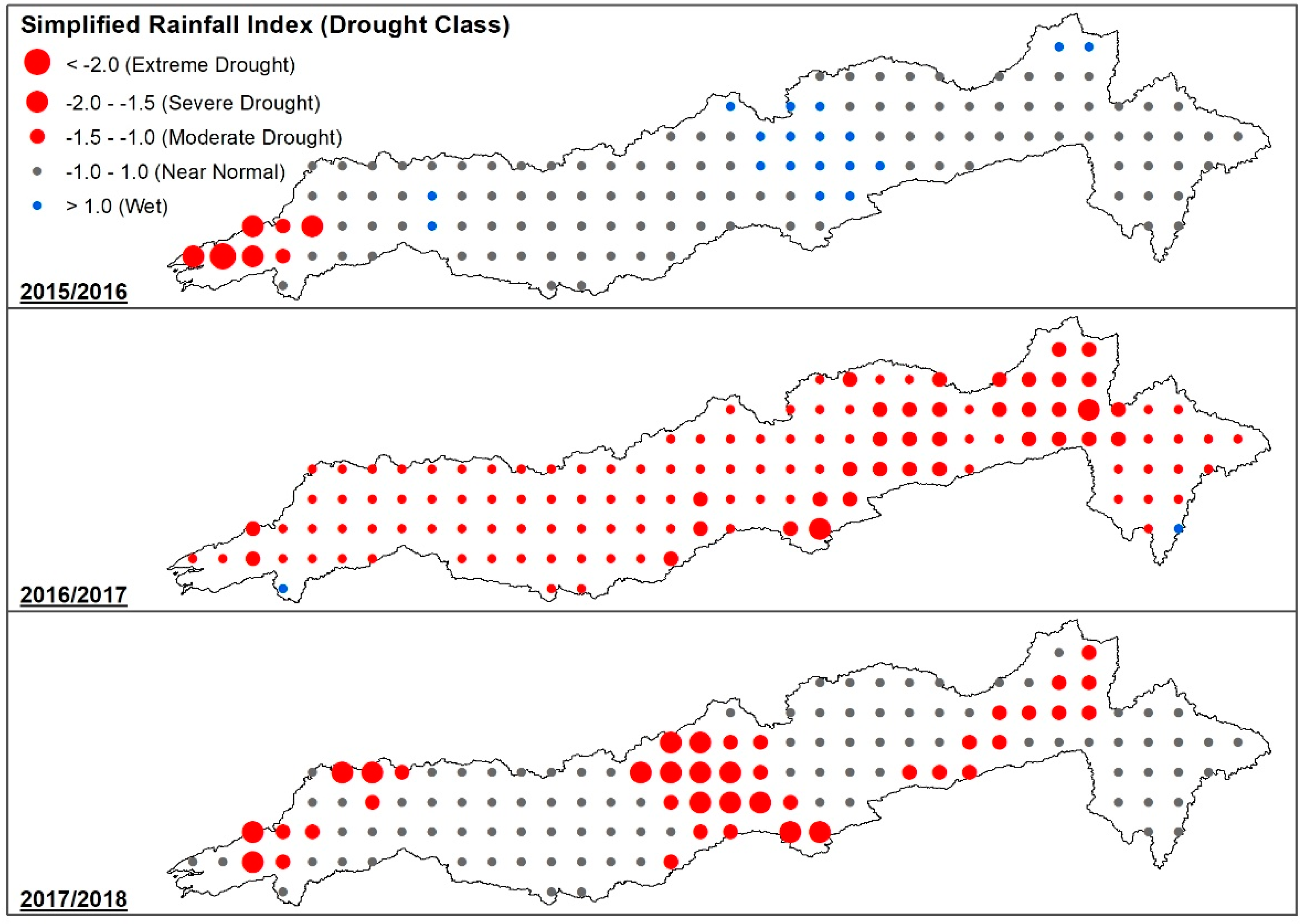
3.1. SPI and RIs over the Narmada Basin
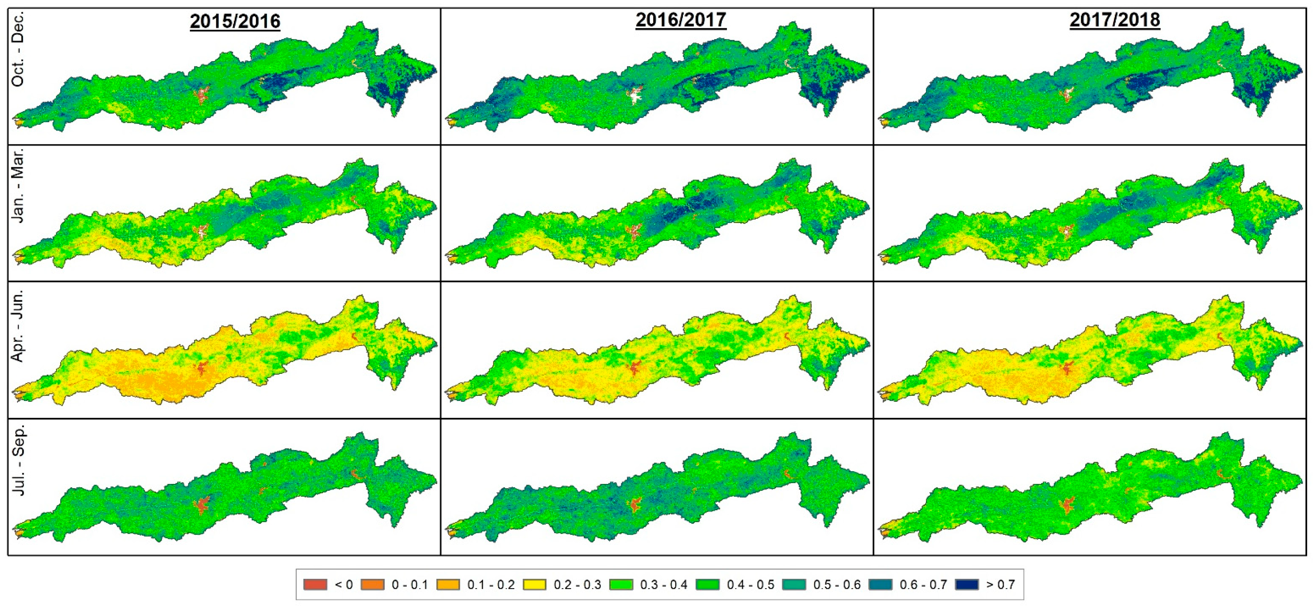
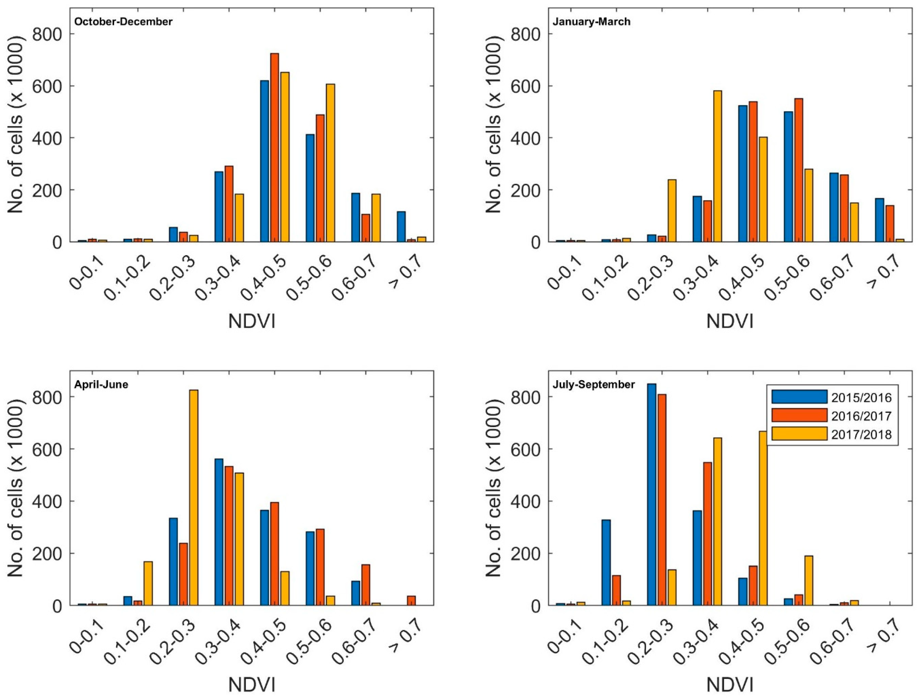
3.2. Changes in the NDVI
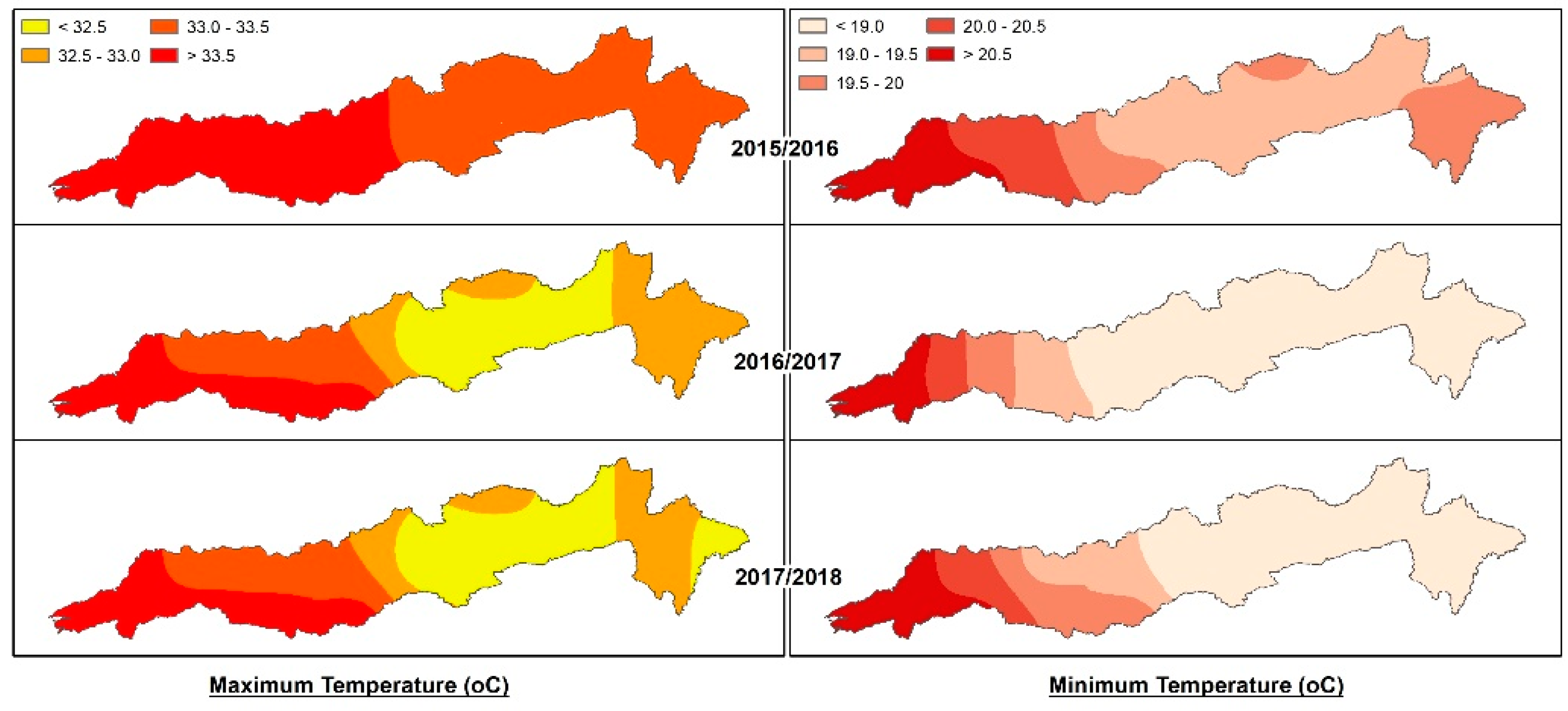
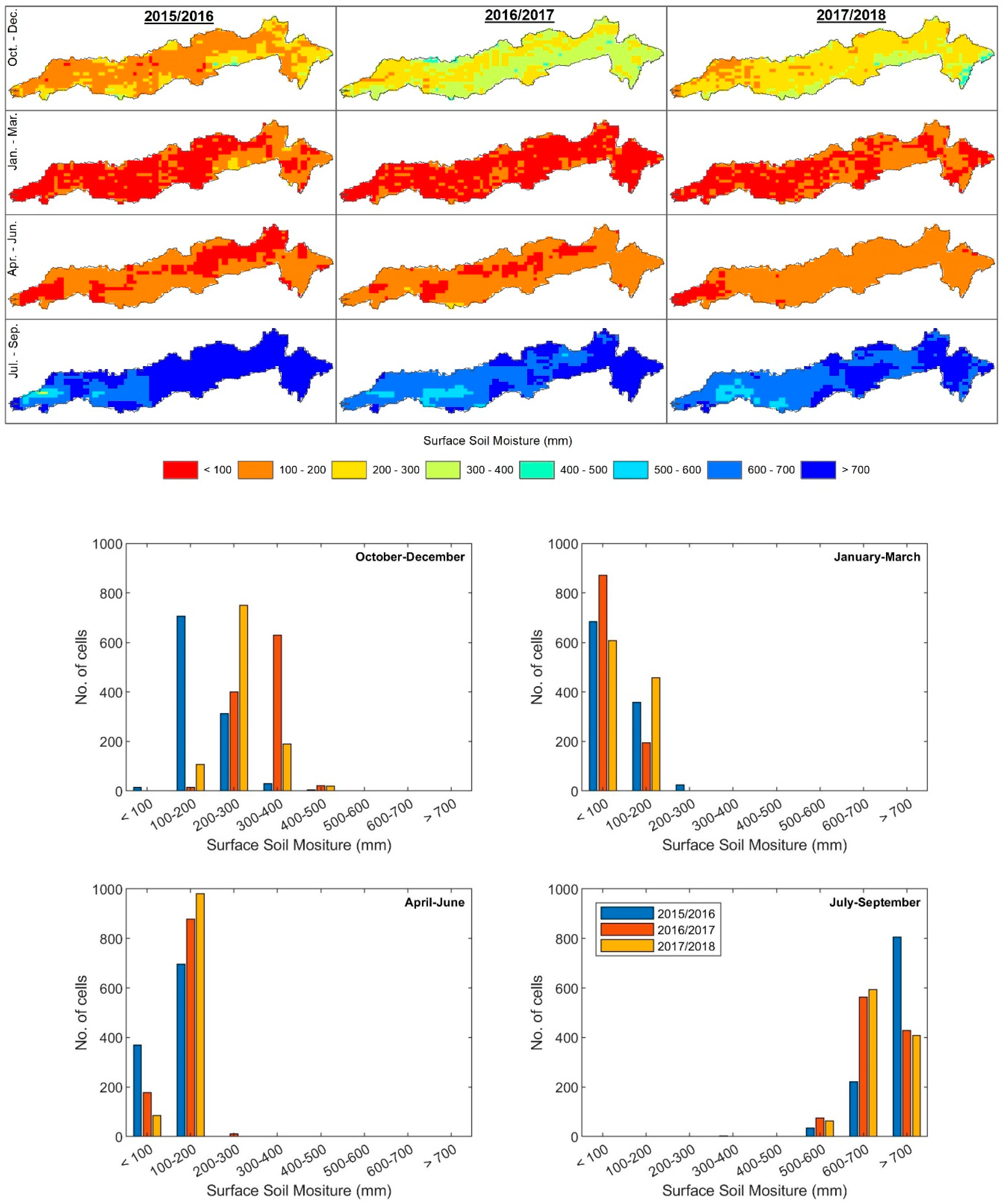
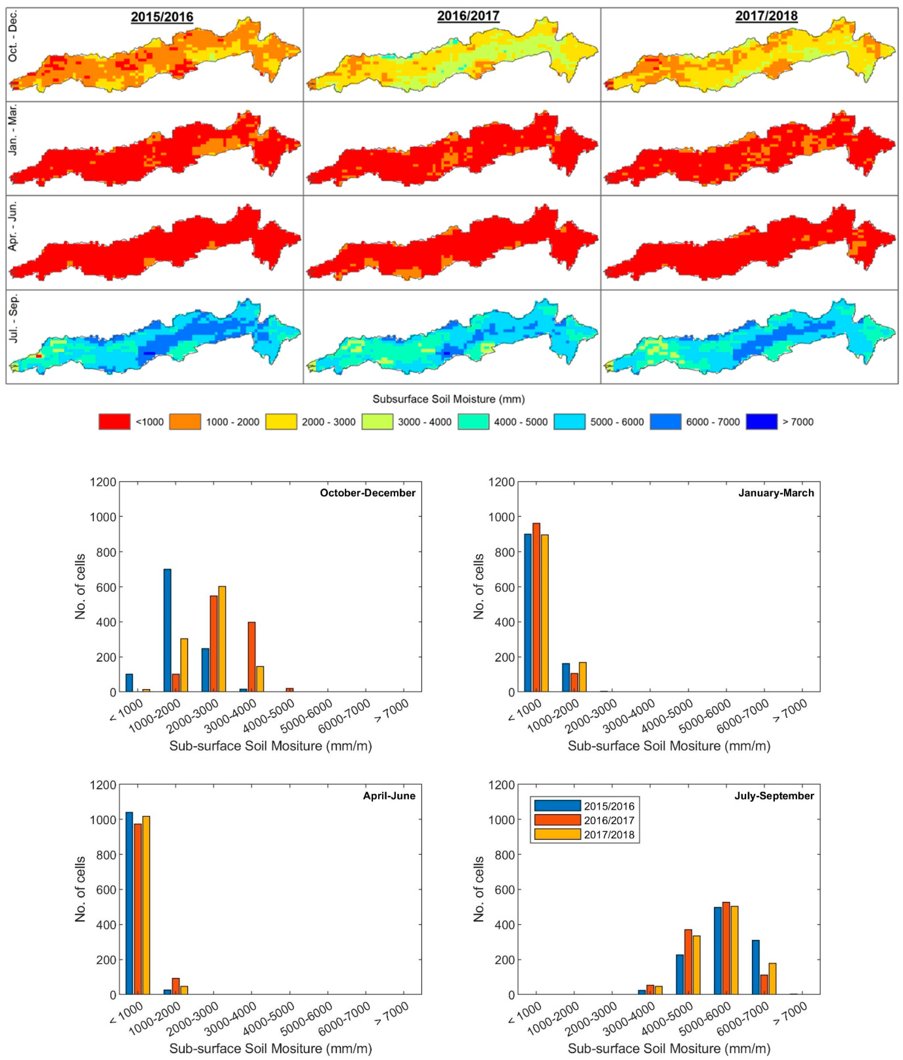
3.3. Changes in the Soil Moisture
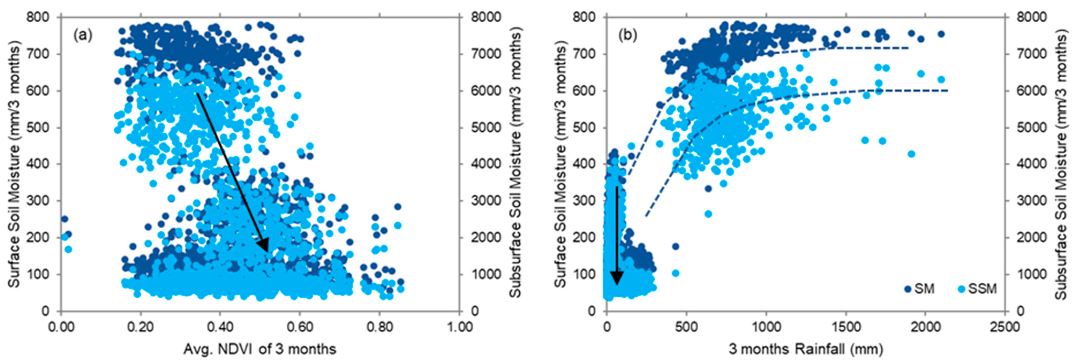
3.4. Relationship between the Rainfall, the NDVI, and the Soil Moisture
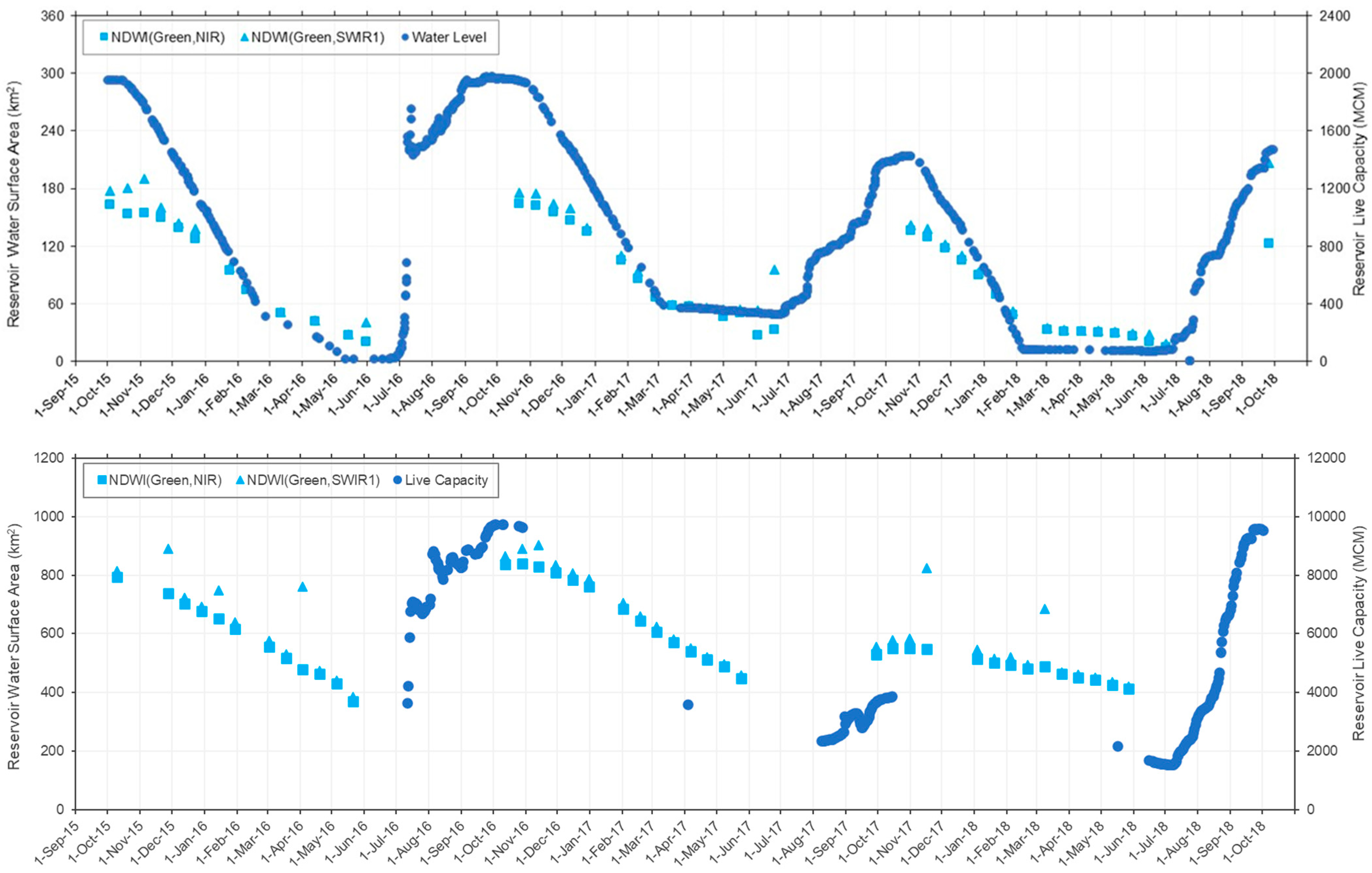
3.5. Reservoir Storage
4. Conclusions
Author Contributions
Funding
Institutional Review Board Statement
Informed Consent Statement
Data Availability Statement
Conflicts of Interest
Appendix A

References
- Dutta, R. Drought Monitoring in the Dry Zone of Myanmar using MODIS Derived NDVI and Satellite Derived CHIRPS Precipitation Data. Sustain. Agric. Res. 2018, 7, 46. [Google Scholar] [CrossRef] [Green Version]
- Wilhite, D.A. Drought as a Natural Hazard: Concepts and Definitions. Drought Mitigation Center Faculty Publications. 2000. Available online: http://digitalcommons.unl.edu/droughtfacpub/69. (accessed on 4 September 2022).
- Mishra, A.K.; Desai, V.R.; Singh, V.P. Drought Forecasting Using a Hybrid Stochastic and Neural Network Model. J. Hydrol. Eng. 2007, 12, 626–638. [Google Scholar] [CrossRef]
- Mishra, A.K.; Singh, V.P. A review of drought concepts. J. Hydrol. 2010, 391, 202–216. [Google Scholar] [CrossRef]
- Singh, O.; Saini, D.; Bhardwaj, P. Characterization of Meteorological Drought over a Dryland Ecosystem in North Western India. Nat. Hazards 2021, 109, 785–826. [Google Scholar] [CrossRef]
- Zhu, Y.; Liu, Y.; Wang, W.; Singh, V.P.; Ma, X.; Yu, Z. Three dimensional characterization of meteorological and hydrological droughts and their probabilistic links. J. Hydrol. 2019, 578, 124016. [Google Scholar] [CrossRef]
- Alahacoon, N.; Edirisinghe, M.; Ranagalage, M. Satellite-based meteorological and agricultural drought monitoring for agricultural sustainability in Sri Lanka. Sustainability 2021, 13, 3427. [Google Scholar] [CrossRef]
- Arshad, S.; Morid, S.; Mobasheri, M.R.; Alikhani, M.A. Development of agricultural drought vulnerability assessment model for Kermanshah Province (Iran) using remote sensing data. Option Mediterrianeennes Ser. A Sémin. Méditerr. 2008, 12, 303–310. [Google Scholar] [CrossRef]
- McFeeters, S.K. The use of the Normalized Difference Water Index (NDWI) in the delineation of open water features. Int. J. Remote Sens. 1996, 17, 1425–1432. [Google Scholar] [CrossRef]
- Van-Rooy, M.P. A Rainfall Anomaly Index (RAI), Independent of the Time and Space. Notos 1965, 14, 43–48. [Google Scholar]
- Tucker, C.J. Red and Photographic Infrared Linear Combinations for Monitoring Vegetation. Remote Sens. Environ. 1979, 8, 127–150. [Google Scholar] [CrossRef] [Green Version]
- Kogan, F.N. Application of vegetation index and brightness temperature for drought detection. Adv. Space Res. 1995, 15, 91–100. [Google Scholar] [CrossRef]
- Hao, Z.; AghaKouchak, A. Multivariate Standardized Drought Index: A parametric multi-index model. Adv. Water Resour. 2013, 57, 12–18. [Google Scholar] [CrossRef] [Green Version]
- Hasson, S.U.; Pascale, S.; Lucarini, V.; Böhner, J. Seasonal cycle of precipitation over major river basins in South and Southeast Asia: A review of the CMIP5 climate models data for present climate and future climate projections. Atmos. Res. 2016, 180, 42–63. [Google Scholar] [CrossRef] [Green Version]
- Mishra, V.; Thirumalai, K.; Jain, S.; Aadhar, S. Unprecedented drought in South India and recent water scarcity. Environ. Reserch Lett. 2021, 2, 56–61. [Google Scholar] [CrossRef]
- Mujumdar, M.; Bhaskar, P. Droughts and floods. In Assessment of Climate Change over the Indian Region; Krishnan, R., Sanjay, J., Gnanaseelan, C., Mujumdar, M., Kulkarni, A., Eds.; Springer: Singapore, 2021; pp. 118–141. ISBN 9789811543265. [Google Scholar]
- Amrit, K.; Pandey, R.P.; Mishra, S.K. Assessment of meteorological drought characteristics over Central India. Sustain. Water Resour. Manag. 2018, 4, 999–1010. [Google Scholar] [CrossRef]
- Udmale, P.; Ichikawa, Y.; Manandhar, S.; Ishidaira, H.; Kiem, A.S. Farmers’ perception of drought impacts, local adaptation and administrative mitigation measures in Maharashtra State, India. Int. J. Disaster Risk Reduct. 2014, 10, 250–269. [Google Scholar] [CrossRef] [Green Version]
- Kumar, K.N.; Rajeevan, M.; Pai, D.S.; Srivastava, A.K.; Preethi, B. On the observed variability of monsoon droughts over India. Weather Clim. Extrem. 2013, 1, 42–50. [Google Scholar] [CrossRef] [Green Version]
- Department of Agriculture and Farmers Welfare Rainfed Farming System. Available online: https://agricoop.nic.in/en/divisiontype/rainfed-farming-system (accessed on 2 December 2021).
- Pandey, R.P.; Pandey, A.; Galkate, R.V.; Byun, H.R.; Mal, B.C. Integrating Hydro-Meteorological and Physiographic Factors for Assessment of Vulnerability to Drought. Water Resour. Manag. 2010, 24, 4199–4217. [Google Scholar] [CrossRef]
- Shah, D.; Mishra, V. Drought Onset and Termination in India. J. Geophys. Res. Atmos. 2020, 125, e2020JD032871. [Google Scholar] [CrossRef]
- Bhardwaj, K.; Shah, D.; Aadhar, S.; Mishra, V. Propagation of Meteorological to Hydrological Droughts in India. J. Geophys. Res. Atmos. 2020, 125, e2020JD033455. [Google Scholar] [CrossRef]
- Vishwakarma, A.; Goswami, A. The dynamics of meteorological droughts over a semi-arid terrain in western India: A last five decadal hydro-climatic evaluation. Groundw. Sustain. Dev. 2022, 16, 100703. [Google Scholar] [CrossRef]
- Shah, D.; Mishra, V. Integrated Drought Index (IDI) for Drought Monitoring and Assessment in India. Water Resour. Res. 2020, 56, e2019WR026284. [Google Scholar] [CrossRef]
- Swain, S.; Mishra, S.K.; Pandey, A. A detailed assessment of meteorological drought characteristics using simplified rainfall index over Narmada River Basin, India. Environ. Earth Sci. 2021, 80, 221. [Google Scholar] [CrossRef]
- FAO. The Digital Soil Map of the World (Version 3.6); Land and Water Development Devision; FAO: Rome, Italy, 2003. [Google Scholar]
- Pandey, B.K.; Khare, D.; Kawasaki, A.; Mishra, P.K. Climate Change Impact Assessment on Blue and Green Water by Coupling of Representative CMIP5 Climate Models with Physical Based Hydrological Model. Water Resour. Manag. 2019, 33, 141–158. [Google Scholar] [CrossRef]
- FAO. World Reference Base for Soil Resources 2014: International Soil Classification System for Naming Soils and Creating Legends for Soil Maps; FAO: Rome, Italy, 2015. [Google Scholar]
- Roy, P.S.; Meiyappan, P.; Joshi, P.K.; Kale, M.P.; Srivastav, V.K.; Srivasatava, S.K.; Behera, M.D.; Roy, A.; Sharma, Y.; Ramachandran, R.M.; et al. Decadal Land Use and Land Cover Classifications Across India, 1985, 1995, 2005; ORNL DAAC: Oak Ridge, TN, USA, 2016. [Google Scholar] [CrossRef]
- Pai, D.S.; Sridhar, L.; Rajeevan, M.; Sreejith, O.P.; Satbhai, N.S.; Mukhopadhyay, B. Development of a new high spatial resolution (0.25° × 0.25°) long period (1901–2010) daily gridded rainfall data set over India and its comparison with existing data sets over the region. Mausam 2014, 65, 1–18. [Google Scholar] [CrossRef]
- Srivastava, A.K.; Rajeevan, M.; Kshirsagar, S.R. Development of a high resolution daily gridded temperature data set (1969–2005) for the Indian region. Atmos. Sci. Lett. 2009, 10, 249–254. [Google Scholar] [CrossRef]
- Didan, K.; Munoz, A.B.; Solano, R.; Huete, A. MODIS Vegetation Index User ’s Guide (MOD13 Series); University of Arizona: Tucson, AZ, USA, 2015. [Google Scholar]
- Didan, K. MOD13Q1 MODIS/Terra Vegetation Indices 16-Day L3 Global 250m SIN Grid V006 [NDVI]. Available online: https://lpdaac.usgs.gov/products/mod13q1v006/ (accessed on 10 August 2021).
- Mladenova, I.E.; Bolten, J.D.; Crow, W.; Sazib, N.; Reynolds, C. Agricultural Drought Monitoring via the Assimilation of SMAP Soil Moisture Retrievals Into a Global Soil Water Balance Model. Front. Big Data 2020, 3, 10. [Google Scholar] [CrossRef] [Green Version]
- Mladenova, I.E.; Bolten, J.D.; Crow, W.T.; Sazib, N.; Cosh, M.H.; Tucker, C.J.; Reynolds, C. Evaluating the Operational Application of SMAP for Global Agricultural Drought Monitoring. IEEE J. Sel. Top. Appl. Earth Obs. Remote Sens. 2019, 12, 3387–3397. [Google Scholar] [CrossRef]
- Sazib, N.; Mladenova, I.; Bolten, J. Leveraging the google earth engine for drought assessment using global soil moisture data. Remote Sens. 2018, 10, 1265. [Google Scholar] [CrossRef] [Green Version]
- Entekhabi, D.; Njoku, E.G.; Neill, P.E.O.; Kellogg, K.H.; Crow, W.T.; Edelstein, W.N.; Entin, J.K.; Goodman, S.D.; Jackson, T.J.; Johnson, J.; et al. The Soil Moisture Active Passive (SMAP) Mission. Proc. IEEE 2010, 98, 704–716. [Google Scholar] [CrossRef]
- McKee, T.B.; Dosken, N.J.; Kleist, J. The relationship of drought frequency and duration to time scales. In Proceedings of the Eighth Conference on Applied Climatology, Anaheim, CA, USA, 17–22 January 1993; pp. 1–6. [Google Scholar]
- McKee, T.B.; Doesken, N.J.; Kleist, J. Drought monitoring with multiple time scales. In Proceedings of the 9th Conference on Applied Climatology, Dallas, TX, USA, 15–20 January 1995; pp. 233–236. [Google Scholar]
- Gandhi, G.M.; Parthiban, S.; Thummalu, N.; Christy, A. Ndvi: Vegetation Change Detection Using Remote Sensing and Gis—A Case Study of Vellore District. Procedia Comput. Sci. 2015, 57, 1199–1210. [Google Scholar] [CrossRef] [Green Version]
- Souza, A.G.S.S.; Ribeiro Neto, A.; Souza, L.L. de Soil moisture-based index for agricultural drought assessment: SMADI application in Pernambuco State-Brazil. Remote Sens. Environ. 2021, 252, 112124. [Google Scholar] [CrossRef]
- Mananze, S.; Pôças, I. Agricultural drought monitoring based on soil moisture derived from the optical trapezoid model in Mozambique. J. Appl. Remote Sens. 2019, 13, 024519. [Google Scholar] [CrossRef]
- Zeri, M.; Williams, K.; Cunha, A.P.M.A.; Cunha-Zeri, G.; Vianna, M.S.; Blyth, E.M.; Marthews, T.R.; Hayman, G.D.; Costa, J.M.; Marengo, J.A.; et al. Importance of including soil moisture in drought monitoring over the Brazilian semiarid region: An evaluation using the JULES model, in situ observations, and remote sensing. Clim. Resil. Sustain. 2021, 1, e7. [Google Scholar] [CrossRef]
- Xu, H. Modification of normalised difference water index (NDWI) to enhance open water features in remotely sensed imagery. Int. J. Remote Sens. 2006, 27, 3025–3033. [Google Scholar] [CrossRef]
- Mbatha, N.; Xulu, S. Time series analysis of MODIS-Derived NDVI for the Hluhluwe-Imfolozi Park, South Africa: Impact of recent intense drought. Climate 2018, 6, 95. [Google Scholar] [CrossRef] [Green Version]
- Zhi, Z.; Yin, H.; Lu, N.; Zhang, X.; Yu, K.; Guo, X.; Qi, H. Spatial-Temporal Changes of Vegetation Restoration in Yan’an Based on MODIS NDVI and Landsat NDVI. In Proceedings of the 2019 IEEE International Conference on Signal, Information and Data Processing (ICSIDP), Chongqing, China, 11–13 December 2019; pp. 2–6. [Google Scholar] [CrossRef]
- CWC; NRSC. Narmada Basin; Central Water Commission: New Delhi, India, 2014. [Google Scholar]


| SPI | RIs | Category |
|---|---|---|
| SPI > 2 | RIs > 2 | Extremely wet |
| 1.5 < SPI ≤ 2 | 1.5 < RIs ≤ 2 | Severely wet |
| 1 < SPI ≤ 1.5 | 1 < RIs ≤ 1.5 | Moderately wet |
| 1 < SPI ≤ −1 | −1 < RIs ≤ 1 | Near Normal |
| −1.5 < SPI ≤ −1 | −1.5 < RIs ≤ −1 | Moderate drought |
| −2 < SPI ≤ −1.5 | −2 < RIs ≤ −1.5 | Severe drought |
| SPI ≤ −2 | RIs ≤ −2 | Extreme drought |
Publisher’s Note: MDPI stays neutral with regard to jurisdictional claims in published maps and institutional affiliations. |
© 2022 by the authors. Licensee MDPI, Basel, Switzerland. This article is an open access article distributed under the terms and conditions of the Creative Commons Attribution (CC BY) license (https://creativecommons.org/licenses/by/4.0/).
Share and Cite
Sirisena, J.; Augustijn, D.; Nazeer, A.; Bamunawala, J. Use of Remote-Sensing-Based Global Products for Agricultural Drought Assessment in the Narmada Basin, India. Sustainability 2022, 14, 13050. https://doi.org/10.3390/su142013050
Sirisena J, Augustijn D, Nazeer A, Bamunawala J. Use of Remote-Sensing-Based Global Products for Agricultural Drought Assessment in the Narmada Basin, India. Sustainability. 2022; 14(20):13050. https://doi.org/10.3390/su142013050
Chicago/Turabian StyleSirisena, Jeewanthi, Denie Augustijn, Aftab Nazeer, and Janaka Bamunawala. 2022. "Use of Remote-Sensing-Based Global Products for Agricultural Drought Assessment in the Narmada Basin, India" Sustainability 14, no. 20: 13050. https://doi.org/10.3390/su142013050