
Evaluation of Satellite-Based and Reanalysis Precipitation Datasets with Gauge-Observed Data over Haraz-Gharehsoo Basin, Iran


Abstract
:1. Introduction
2. Materials and Methods
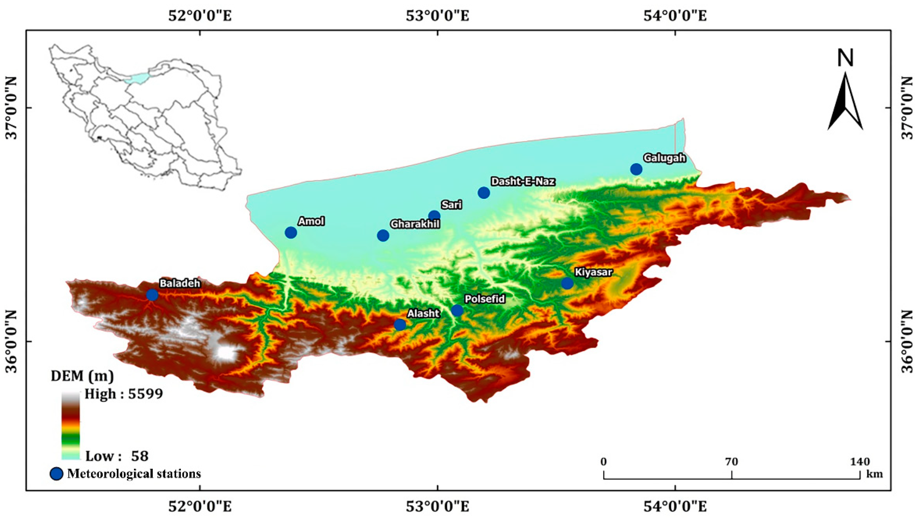
2.1. Study Area
2.2. Data Sets
2.2.1. Basic and Gauge-Observed Data
2.2.2. Remote Sensing Precipitation Data
2.3. Methodology
2.3.1. Data Preparation and Technical Framework
2.3.2. Evaluation of Statistical Metrics
3. Results and Discussion
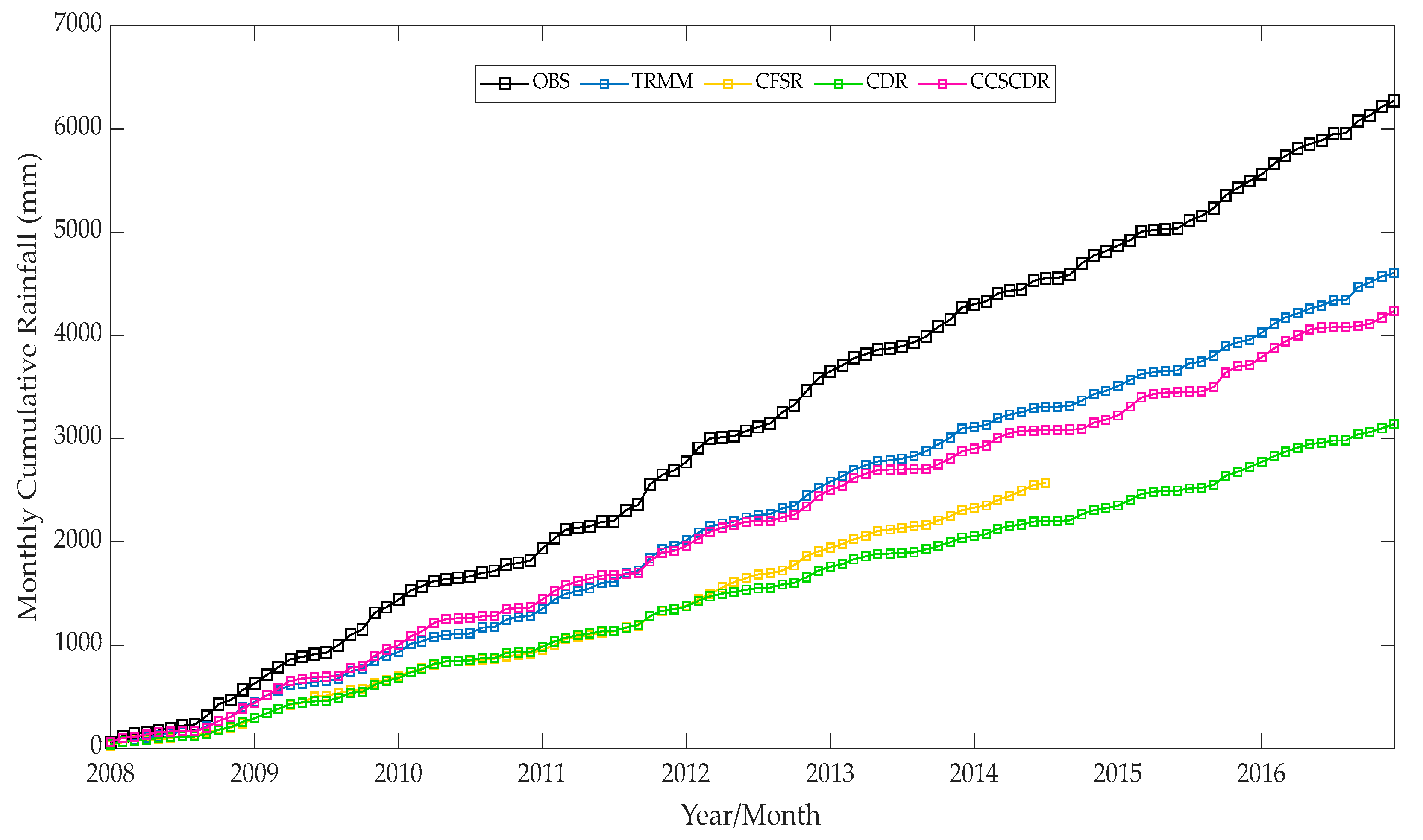
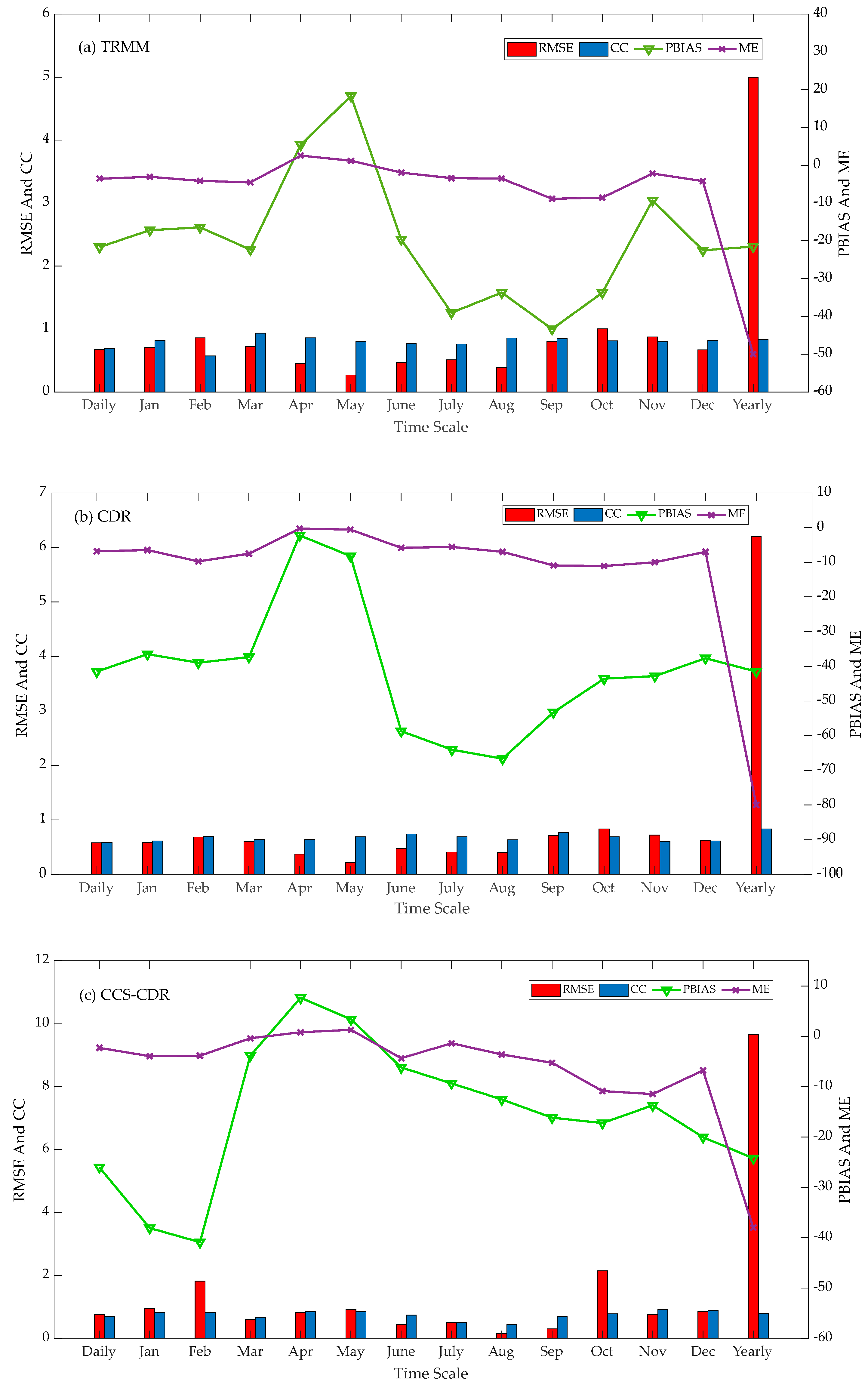
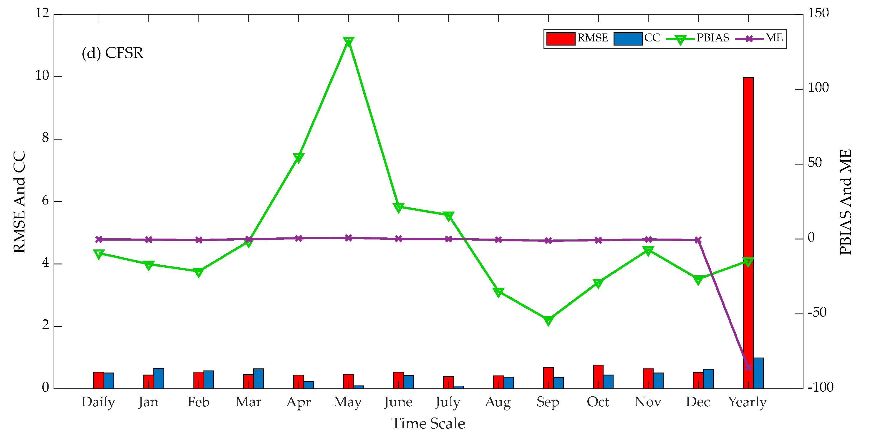
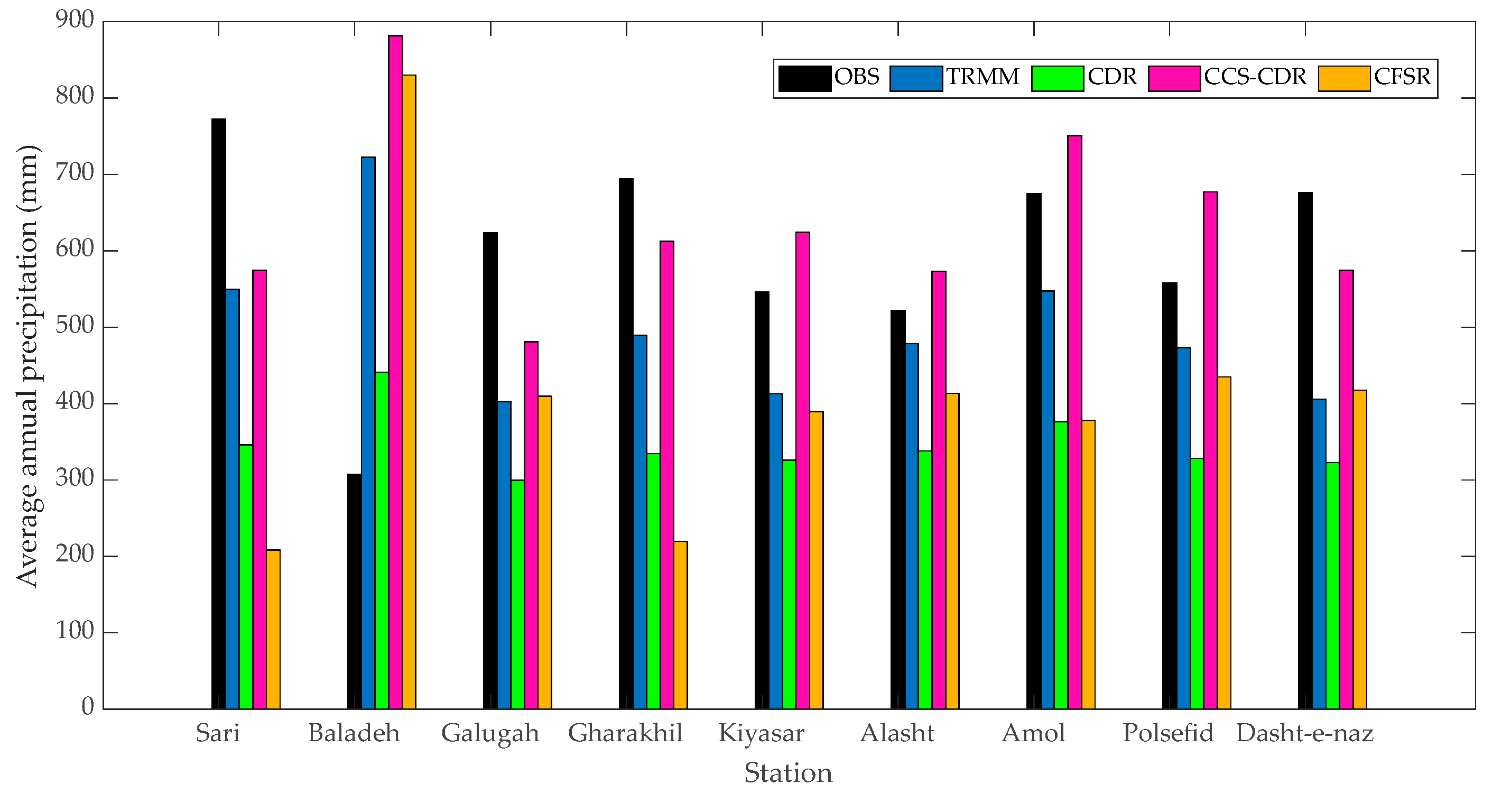
3.1. Comparison and Evaluation of Satellite-Based Precipitation Data against Gauge-Observed Products
3.2. Error Decomposition of TRMM Products
4. Conclusions
- (1)
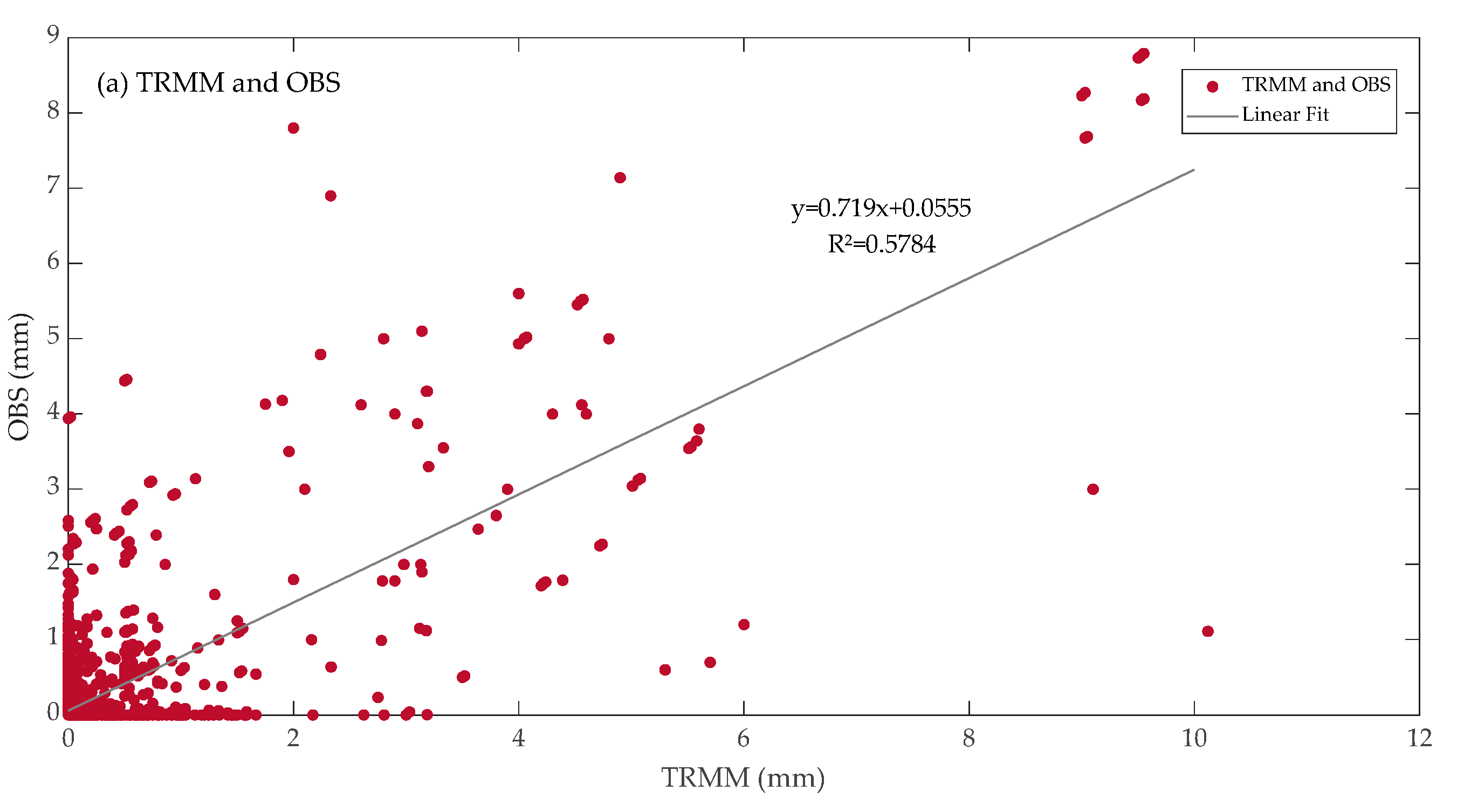
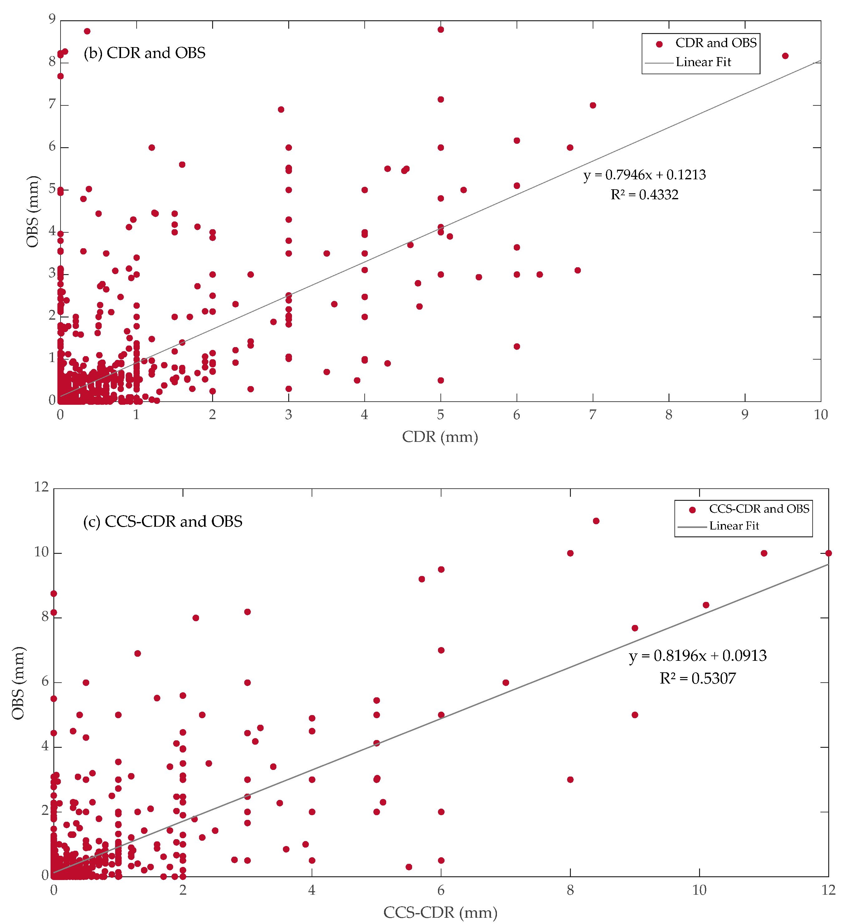
- Four remote sensing products evaluated in this study generally have an underestimation trend, while the TRMM and CCS-CDR products have better performance.
- (2)
- The rainfall amounts of satellite-based products were examined precisely at the coordinates of gauge-observed stations by interpolating the data to assess the accuracy of satellite-based data better.
- (3)
- Four of the TRMM, CDR, CCS-CDR, and CFSR products underestimate precipitation on daily, monthly, and annual scales, while the underestimations of CDR and CFSR are more remarkable than that of TRMM and CCS-CDR.
- (4)
- Comparing the satellite products showed that the former performed better than the latter from April to September.
- (5)
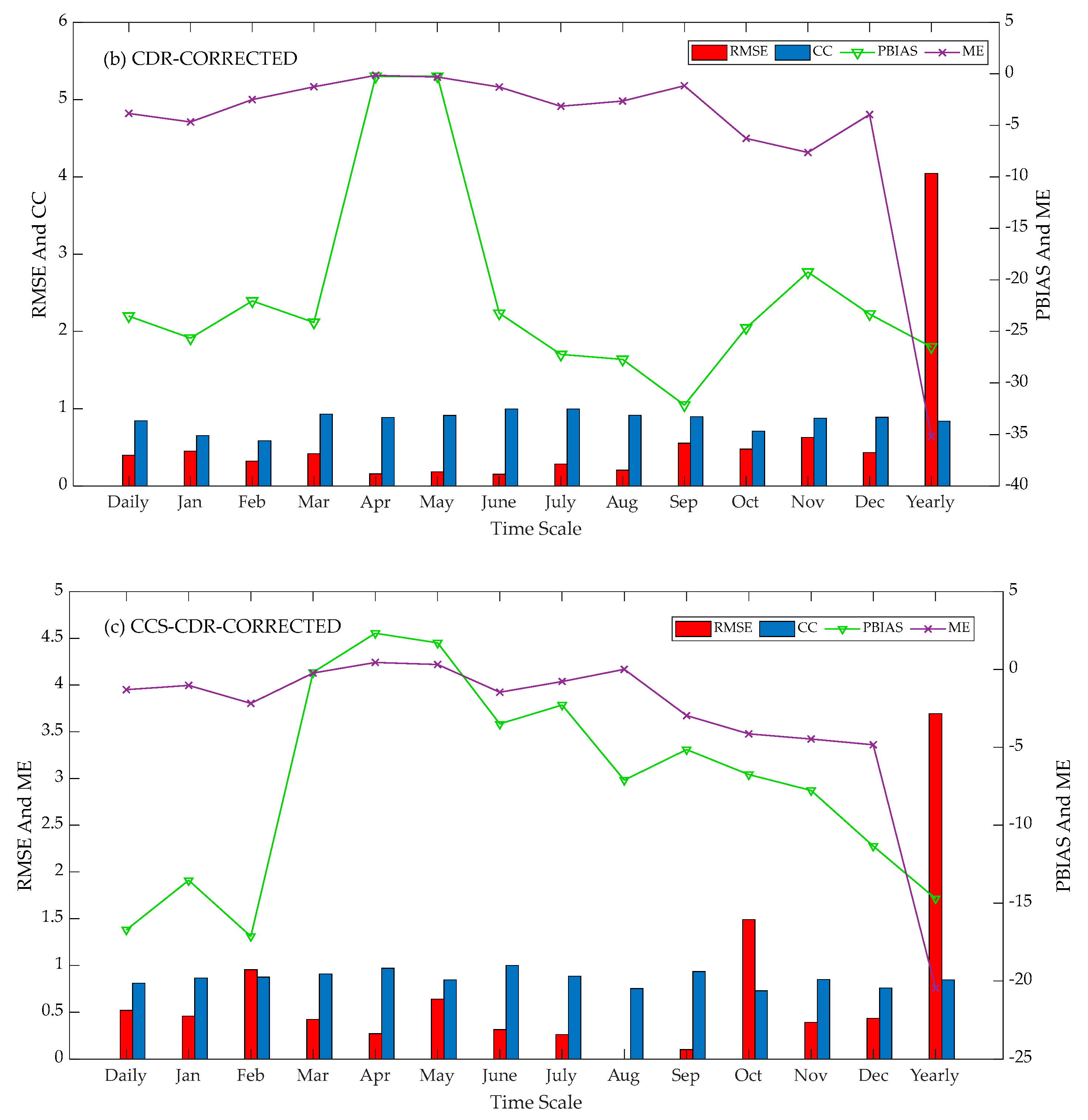
- By constructing the decomposition data error model, the CC, ME, RMSE, and PBIAS became closer to optimal values, especially on daily and monthly scales.
- (6)
- On the diurnal scale, TRMM has the best precision for detecting rainfall occurrences, with CSI 0.71, followed by CCS-CDR, CDR, and CFSR. Moreover, TRMM, with a POD of 0.51, has a powerful capability to make reliable rainfall estimations.
- (7)
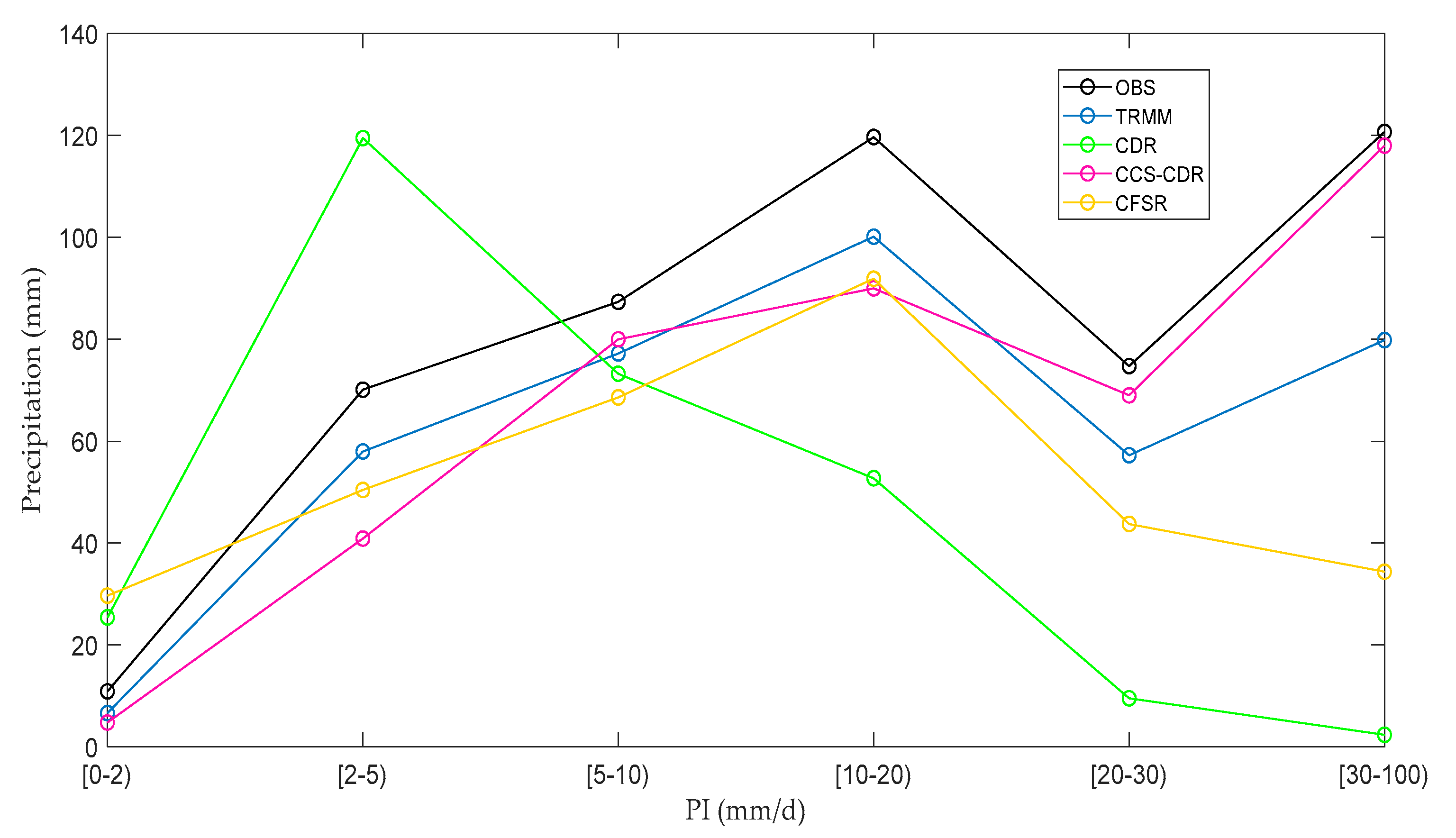
- By comparing the precipitation intensity for TRMM and other products, it was found that the TRMM data has optimal statistical values when the PI range is [5, 10) by CC = 0.876 and RMSE 0.336 mm. Additionally, the worst performance belongs to CDR products in the PI range of [20, 30) by CC = 0.004 and RMSE = 4.625. This implies that the TRMM estimation is closer to OBS.
- (8)
- CCS-CDR provides more accurate results than CDR products.
Author Contributions
Funding
Institutional Review Board Statement
Informed Consent Statement
Data Availability Statement
Acknowledgments
Conflicts of Interest
References
- Deng, P.; Zhang, M.; Bing, J.; Jia, J.; Zhang, D. Evaluation of the GSMaP_Gauge products using rain gauge observations and SWAT model in the Upper Hanjiang River Basin. Atmos. Res. 2019, 219, 153–165. [Google Scholar] [CrossRef]
- Sharma, S.; Isik, S.; Srivastava, P.; Kalin, L. Deriving spatially distributed precipitation data using the artificial neural network and multilinear regression models. J. Hydrol. Eng. 2013, 18, 194–205. [Google Scholar] [CrossRef] [Green Version]
- Yong, B.; Chen, B.; Gourley, J.J.; Ren, L.; Hong, Y.; Chen, X.; Wang, W.; Chen, S.; Gong, L. Intercomparison of the Version-6 and Version-7 TMPA precipitation products over high and low latitudes basins with independent gauge networks: Is the newer version better in both real-time and post-real-time analysis for water resources and hydrologic extremes? J. Hydrol. 2014, 508, 77–87. [Google Scholar]
- Schwarzenbach, R.P.; Escher, B.I.; Fenner, K.; Hofstetter, T.B.; Johnson, C.A.; von Gunten, U.; Wehrli, B. The challenge of micropollutants in aquatic systems. Science 2006, 313, 1072–1077. [Google Scholar] [CrossRef] [PubMed]
- Zahabiyoun, B.; Goodarzi, M.; Bavani, A.M.; Azamathulla, H.M. Assessment of climate change impact on the Gharesou River Basin using SWAT hydrological model. CLEAN–Soil Air Water 2013, 41, 601–609. [Google Scholar] [CrossRef]
- Leta, O.T.; El-Kadi, A.I.; Dulai, H.; Ghazal, K.A. Assessment of climate change impacts on water balance components of Heeia watershed in Hawaii. J. Hydrol. Reg. Stud. 2016, 8, 182–197. [Google Scholar] [CrossRef] [Green Version]
- Duarte, L.V.; Formiga, K.T.M.; Costa, V.A.F. Analysis of the IMERG-GPM Precipitation Product Analysis in Brazilian Midwestern Basins Considering Different Time and Spatial Scales. Water 2022, 14, 2472. [Google Scholar] [CrossRef]
- Niu, P.; Zhang, E.; Feng, Y.; Peng, P. Spatial-Temporal Pattern Analysis of Land Use and Water Yield in Water Source Region of Middle Route of South-to-North Water Transfer Project Based on Google Earth Engine. Water 2022, 14, 2535. [Google Scholar] [CrossRef]
- Liu, X.; Yang, T.; Hsu, K.; Liu, C.; Sorooshian, S. Evaluating the streamflow simulation capability of PERSIANN-CDR daily rainfall products in two river basins on the Tibetan Plateau. Hydrol. Earth Syst. Sci. 2017, 21, 169–181. [Google Scholar] [CrossRef] [Green Version]
- Mekonnen, K.; Melesse, A.M.; Woldesenbet, T.A. Spatial evaluation of satellite-retrieved extreme rainfall rates in the Upper Awash River Basin, Ethiopia. Atmos. Res. 2021, 249, 105297. [Google Scholar] [CrossRef]
- Acharya, S.C.; Nathan, R.; Wang, Q.J.; Su, C.-H.; Eizenberg, N. An evaluation of daily precipitation from a regional atmospheric reanalysis over Australia. Hydrol. Earth Syst. Sci. 2019, 23, 3387–3403. [Google Scholar] [CrossRef]
- Tian, Y.; Peters-Lidard, C.D.; Adler, R.F.; Kubota, T.; Ushio, T. Evaluation of GSMaP precipitation estimates over the contiguous United States. J. Hydrometeorol. 2010, 11, 566–574. [Google Scholar] [CrossRef]
- Duan, Z.; Tuo, Y.; Liu, J.; Gao, H.; Song, X.; Zhang, Z.; Yang, L.; Mekonnen, D.F. Hydrological evaluation of open-access precipitation and air temperature datasets using SWAT in a poorly gauged basin in Ethiopia. J. Hydrol. 2019, 569, 612–626. [Google Scholar] [CrossRef] [Green Version]
- Kidd, C.; Becker, A.; Huffman, G.J.; Muller, C.L.; Joe, P.; Skofronick-Jackson, G.; Kirschbaum, D.B. So, how much of the Earth’s surface is covered by rain gauges? Bull. Am. Meteorol. Soc. 2017, 98, 69–78. [Google Scholar] [CrossRef]
- Li, D.; Christakos, G.; Ding, X.; Wu, J. Adequacy of TRMM satellite rainfall data in driving the SWAT modeling of Tiaoxi catchment (Taihu lake basin, China). J. Hydrol. 2018, 556, 1139–1152. [Google Scholar] [CrossRef]
- Tong, K.; Su, F.; Yang, D.; Hao, Z. Evaluation of satellite precipitation retrievals and their potential utilities in hydrologic modeling over the Tibetan Plateau. J. Hydrol. 2014, 519, 423–437. [Google Scholar] [CrossRef]
- Essou, G.R.; Sabarly, F.; Lucas-Picher, P.; Brissette, F.; Poulin, A. Can precipitation and temperature from meteorological reanalyses be used for hydrological modeling? J. Hydrometeorol. 2016, 17, 1929–1950. [Google Scholar] [CrossRef]
- Ebert, E.E.; Janowiak, J.E.; Kidd, C. Comparison of near-real-time precipitation estimates from satellite observations and numerical models. Bull. Am. Meteorol. Soc. 2007, 88, 47–64. [Google Scholar] [CrossRef] [Green Version]
- Xue, X.; Hong, Y.; Limaye, A.S.; Gourley, J.J.; Huffman, G.J.; Khan, S.I.; Dorji, C.; Chen, S. Statistical and hydrological evaluation of TRMM-based Multi-satellite Precipitation Analysis over the Wangchu Basin of Bhutan: Are the latest satellite precipitation products 3B42V7 ready for use in ungauged basins? J. Hydrol. 2013, 499, 91–99. [Google Scholar] [CrossRef]
- Meng, J.; Li, L.; Hao, Z.; Wang, J.; Shao, Q. Suitability of TRMM satellite rainfall in driving a distributed hydrological model in the source region of Yellow River. J. Hydrol. 2014, 509, 320–332. [Google Scholar] [CrossRef]
- Wang, N.; Yao, Z.; Liu, W.; Lv, X.; Ma, M. Spatial variabilities of runoff erosion and different underlying surfaces in the Xihe river basin. Water 2019, 11, 352. [Google Scholar] [CrossRef]
- Li, X.; Long, D.; Han, Z.; Scanlon, B.R.; Sun, Z.; Han, P.; Hou, A. Evapotranspiration estimation for Tibetan Plateau headwaters using conjoint terrestrial and atmospheric water balances and multisource remote sensing. Water Resour. Res. 2019, 55, 8608–8630. [Google Scholar] [CrossRef]
- Kimani, M.W.; Hoedjes, J.C.; Su, Z. An assessment of satellite-derived rainfall products relative to ground observations over East Africa. Remote Sens. 2017, 9, 430. [Google Scholar] [CrossRef] [Green Version]
- Zhang, Y.; Ma, N. Spatiotemporal variability of snow cover and snow water equivalent in the last three decades over Eurasia. J. Hydrol. 2018, 559, 238–251. [Google Scholar] [CrossRef]
- Huffman, G.J.; Bolvin, D.T.; Nelkin, E.J.; Wolff, D.B.; Adler, R.F.; Gu, G.; Hong, Y.; Bowman, K.P.; Stocker, E.F. The TRMM multisatellite precipitation analysis (TMPA): Quasi-global, multiyear, combined-sensor precipitation estimates at fine scales. J. Hydrometeorol. 2007, 8, 38–55. [Google Scholar] [CrossRef]
- Joyce, R.J.; Janowiak, J.E.; Arkin, P.A.; Xie, P. CMORPH: A method that produces global precipitation estimates from passive microwave and infrared data at high spatial and temporal resolution. J. Hydrometeorol. 2004, 5, 487–503. [Google Scholar] [CrossRef]
- Thorne, V.; Coakeley, P.; Grimes, D.; Dugdale, G. Comparison of TAMSAT and CPC rainfall estimates with raingauges, for southern Africa. Int. J. Remote Sens. 2001, 22, 1951–1974. [Google Scholar] [CrossRef]
- Maidment, R.I.; Grimes, D.; Black, E.; Tarnavsky, E.; Young, M.; Greatrex, H.; Allan, R.P.; Stein, T.; Nkonde, E.; Senkunda, S.; et al. A new, long-term daily satellite-based rainfall dataset for operational monitoring in Africa. Sci. Data 2017, 4, 1–19. [Google Scholar]
- Sorooshian, S.; Hsu, K.-L.; Gao, X.; Gupta, H.V.; Imam, B.; Braithwaite, D. Evaluation of PERSIANN system satellite-based estimates of tropical rainfall. Bull. Am. Meteorol. Soc. 2000, 81, 2035–2046. [Google Scholar] [CrossRef]
- Ashouri, H.; Hsu, K.-L.; Sorooshian, S.; Braithwaite, D.K.; Knapp, K.R.; Cecil, L.D.; Nelson, B.R.; Prat, O.P. PERSIANN-CDR: Daily precipitation climate data record from multisatellite observations for hydrological and climate studies. Bull. Am. Meteorol. Soc. 2015, 96, 69–83. [Google Scholar] [CrossRef] [Green Version]
- Prakash, S. Performance assessment of CHIRPS, MSWEP, SM2RAIN-CCI, and TMPA precipitation products across India. J. Hydrol. 2019, 571, 50–59. [Google Scholar] [CrossRef]
- Sadeghi, M.; Nguyen, P.; Naeini, M.R.; Hsu, K.; Braithwaite, D.; Sorooshian, S. PERSIANN-CCS-CDR, a 3-hourly 0.04° global precipitation climate data record for heavy precipitation studies. Sci. Data 2021, 8, 1–11. [Google Scholar] [CrossRef] [PubMed]
- Xie, P.; Arkin, P.A. An intercomparison of gauge observations and satellite estimates of monthly precipitation. J. Appl. Meteorol. Climatol. 1995, 34, 1143–1160. [Google Scholar] [CrossRef]
- Darand, M.; Amanollahi, J.; Zandkarimi, S. Evaluation of the performance of TRMM Multi-satellite Precipitation Analysis (TMPA) estimation over Iran. Atmos. Res. 2017, 190, 121–127. [Google Scholar] [CrossRef]
- Javanmard, S.; Yatagai, A.; Nodzu, M.; BodaghJamali, J.; Kawamoto, H. Comparing high-resolution gridded precipitation data with satellite rainfall estimates of TRMM_3B42 over Iran. Adv. Geosci. 2010, 25, 119–125. [Google Scholar] [CrossRef] [Green Version]
- Deng, P.; Zhang, M.; Guo, H.; Xu, C.; Bing, J.; Jia, J. Error analysis and correction of the daily GSMaP products over Hanjiang River Basin of China. Atmos. Res. 2018, 214, 121–134. [Google Scholar] [CrossRef]
- Guo, H.; Chen, S.; Bao, A.; Behrangi, A.; Hong, Y.; Ndayisaba, F.; Hu, J.; Stepanian, P.M. Early assessment of integrated multi-satellite retrievals for global precipitation measurement over China. Atmos. Res. 2016, 176, 121–133. [Google Scholar] [CrossRef]
- Hırca, T.; Türkkan, G.E.; Niazkar, M. Applications of innovative polygonal trend analyses to precipitation series of Eastern Black Sea Basin, Turkey. Theor. Appl. Climatol. 2022, 147, 651–667. [Google Scholar] [CrossRef]
- Tan, J.; Petersen, W.A.; Tokay, A. A novel approach to identify sources of errors in IMERG for GPM ground validation. J. Hydrometeorol. 2016, 17, 2477–2491. [Google Scholar] [CrossRef]
- Tan, X.; Yong, B.; Ren, L. Error features of the hourly GSMaP multi-satellite precipitation estimates over nine major basins of China. Hydrol. Res. 2018, 49, 761–779. [Google Scholar] [CrossRef] [Green Version]
- Gupta, M.; Srivastava, P.K.; Islam, T.; Ishak, A.M.B. Evaluation of TRMM rainfall for soil moisture prediction in a subtropical climate. Environ. Earth Sci. 2014, 71, 4421–4431. [Google Scholar] [CrossRef]
- Gadouali, F.; Messouli, M. Evaluation of multiple satellite-derived rainfall products over Morocco. Int. J. Hydrol. Sci. Technol. 2020, 10, 72–89. [Google Scholar] [CrossRef]
- Hu, Z.; Hu, Q.; Zhang, C.; Chen, X.; Li, Q. Evaluation of reanalysis, spatially interpolated and satellite remotely sensed precipitation data sets in central Asia. J. Geophys. Res. Atmos. 2016, 121, 5648–5663. [Google Scholar] [CrossRef] [Green Version]
- Shayeghi, A.; Azizian, A.; Brocca, L. Reliability of reanalysis and remotely sensed precipitation products for hydrological simulation over the Sefidrood River Basin, Iran. Hydrol. Sci. J. 2020, 65, 296–310. [Google Scholar] [CrossRef]
- Kawo, N.S.; Hordofa, A.T.; Karuppannan, S. Performance evaluation of GPM-IMERG early and late rainfall estimates over Lake Hawassa catchment, Rift Valley Basin, Ethiopia. Arab. J. Geosci. 2021, 14, 1–14. [Google Scholar] [CrossRef]
- Wang, L.; Chen, R.; Song, Y. Research review on calculation methods and influential factors on areal precipitation of alpine mountains. Plateau Meteorol. 2017, 36, 1546–1556. [Google Scholar]
- Goodarzi, M.R.; Sabaghzadeh, M.; Mokhtari, M.H. Impacts of aspect on snow characteristics using remote sensing from 2000 to 2020 in Ajichai-Iran. Cold Reg. Sci. Technol. 2022, 204, 103682. [Google Scholar] [CrossRef]


| Datasets | Daily | Jan | Feb | Mar | Apr | May | June | July | Aug | Sep | Oct | Nov | Dec | Annual |
|---|---|---|---|---|---|---|---|---|---|---|---|---|---|---|
| Gauge-Observed | 1.64 | 55.1 | 70.7 | 62.5 | 32.3 | 20.4 | 29.6 | 26.9 | 32.4 | 61.3 | 78.8 | 69.8 | 57.5 | 597.3 |
| TRMM | 1.38 | 45.6 | 59.1 | 48.5 | 34.1 | 24.1 | 23.8 | 22.4 | 26.3 | 52.7 | 52.2 | 63.3 | 44.6 | 496.7 |
| CDR CFSR CCS-CDR | 0.96 1.12 1.31 | 34.9 34.7 54.2 | 43.2 40.9 65.7 | 39.2 42.6 60.7 | 31.6 33.9 48.9 | 18.7 32.7 28.9 | 12.2 29.1 13.5 | 9.7 15.3 3.5 | 10.8 19.9 4.2 | 28.7 20.1 25.2 | 44.5 40.5 54.9 | 39.9 46.7 61.7 | 35.9 34.1 48.9 | 349.3 390.5 470.3 |
| Name | Longitude (°E) | Latitude (°N) | Elevation (m) |
|---|---|---|---|
| Sari | 52.98 | 36.53 | 23 |
| Baladeh | 51.8 | 36.2 | 2120 |
| Galugah | 53.83 | 36.73 | −10 |
| Gharakhil | 52.77 | 36.45 | 14.7 |
| Kiyasar | 53.54 | 36.24 | 1294.3 |
| Alasht | 52.84 | 36.07 | 1805 |
| Amol | 52.38 | 36.46 | 23.7 |
| Polsfid | 53.08 | 36.13 | 610 |
| Sari (Dasht-E- Naz airport) | 53.19 | 36.63 | 16.7 |
| Datasets | Name | Spatial Resolution | Temporal Resolution | Period | Coverage |
|---|---|---|---|---|---|
| TRMM-3B42V7 | TRMM | 0.25° | Daily | 2008–2016 | 50° S–50° N |
| PERSIANN-CDR NCEP-CFSR PERSIANN-CCS-CDR | CDR CFSR CCS-CDR | 0.25° 38 km 0.04° | Daily Daily 3-hourly | 2008–2016 2008–2014 2008–2016 | 60° S–60° N labolG 60° S–60° N |
| Gauge-Observed | OBS | Point | Daily | 2008–2016 | Haraz-Gharehsoo Basin |
| Number | Abbreviation | Definition | Unit | Function | Description |
|---|---|---|---|---|---|
| (1) | ME | Mean Error | mm | Gi: Gauge-observed precipitation. | |
| (2) | RMSE | Root Mean Square Error | mm | )2 | Si: Precipitation that is driven by satellite-based products. |
| (3) | PBIAS | Percentage Bias | % | × 100% | H: Correct detection of the observed rainfall. |
| (4) | CC | Correlation Coefficient | M: The observed rainfall is not detected. | ||
| (5) | POD | Probability Of Detection | F: The rainfall is detected but not observed. | ||
| (6) | FAR | False Alarm Ratio | = | ||
| (7) | CSI | Critical Success Index | = | ||
| (8) | BID | Bias In Detection | : 30 min/3-hourly PERSIANN-CCS estimate (0.04° spatial resolution) | ||
| i: Latitude of the 30 min/3-hourly PERSIANN-CCS at 0.04° × 0.04°. | |||||
| (9) | RCum-PERSIANN-CCS (i’, j’) | Monthly 2.5° aggregated PERSIANN-CCS estimate | RCum-PERSIANN-CCS (i’, j’) = | j: Longitude of the 30 min/3-hourly PERSIANN-CCS at 0.04° × 0.04°. | |
| (10) | w (i’, j’) | Bias adjustment weights for each monthly 2.5° grid cell | w (i’, j’) = RCDR (i’, j’)/R Cum-PERSIANN-CCS (i’, j’) 0 ≤ w ≤ 2.5 | i’: Latitude of the aggregated PERSIANN-CCS at 2.5° × 2.5°. | |
| (11) | PERSIANN-CCS-CDR (i, j) | Final PERSIANN-CCS-CDR product | (i, j) | j’: Longitude of the aggregated PERSIANN-CCS at 2.5° × 2.5°. |
| Satellite | POD | FAR | BID | CSI |
|---|---|---|---|---|
| TRMM | 0.51 | 0.42 | 0.82 | 0.71 |
| CDR | 0.39 | 0.25 | 0.93 | 0.54 |
| CCS-CDR | 0.45 | 0.34 | 0.86 | 0.59 |
| CFSR | 0.42 | 0.17 | 0.95 | 0.53 |
| PI (mm/Day) | TRMM | CDR | ||||||
|---|---|---|---|---|---|---|---|---|
| CC | RMSE (mm) | ME (mm) | PBIAS (%) | CC | RMSE (mm) | ME (mm) | PBIAS (%) | |
| [0,2) | 0.060 | 0.018 | −0.017 | −39.054 | 0.122 | 0.028 | 0.061 | 133.059 |
| [2, 5) | 0.709 | 0.192 | −0.404 | −17.293 | 0.002 | 0.200 | 0.945 | 70.429 |
| [5, 10) | 0.876 | 0.336 | −0.778 | −11.598 | 0.119 | 0.345 | −1.083 | −16.125 |
| [10, 20) | 0.867 | 0.701 | −2.274 | −16.549 | 0.101 | 1.067 | −7.702 | −56.045 |
| [20, 30) | 0.795 | 1.205 | −5.550 | −23.398 | 0.457 | 2.225 | −20.755 | −87.213 |
| [30, 100) | 0.623 | 3.277 | −14.960 | −33.843 | 0.004 | 4.625 | −43.332 | −98.024 |
| CCS−CDR | CFSR | |||||||
| CC | RMSE (mm) | ME (mm) | PBIAS (%) | CC | RMSE (mm) | ME (mm) | PBIAS (%) | |
| [0,2) | 0.032 | 0.045 | −0.258 | −43.869 | 0.007 | 0.062 | 0.156 | 22.691 |
| [2, 5) | 0.377 | 0.369 | −1.854 | −12.483 | 0.353 | 0.315 | 2.922 | 28.646 |
| [5, 10) | 0.564 | 0.257 | −0.212 | −5.816 | 0.350 | 0.682 | 6.290 | 7.290 |
| [10, 20) | 0.687 | 0.153 | −1.864 | −14.267 | 0.349 | 1.320 | 12.010 | 26.576 |
| [20, 30) | 0.886 | 0.098 | −6.427 | −26.364 | 0.467 | 2.148 | 18.492 | 33.178 |
| [30, 100) | 0.957 | 0.754 | −8.733 | −37.125 | 0.397 | 8.961 | 21.621 | 51.178 |
| TRMM ≥ 0.1 mm/h | TRMM < 0.1 mm/h | |
|---|---|---|
| OBS≥0.1 mm/h | 2471 (8.35%) | 2968 (10.03%) |
| OBS<0.1 mm/h | 1030 (3.48%) | 23123 (78.14%) |
| OBS≥0.1 mm/h | CDR ≥ 0.1 mm/h | CDR < 0.1 mm/h |
| 2638 (8.92%) | 3132 (10.58%) | |
| OBS < 0.1 mm/h | 866 (2.93%) | 22956 (77.57%) |
| CCS-CDR ≥ 0.1 mm/h | CCS-CDR < 0.1 mm/h | |
| OBS≥0.1 mm/h | 2856 (9.65%) | 3223 (10.89%) |
| OBS < 0.1 mm/h | 923 (3.12%) | 22590 (76.34%) |
| CFSR ≥ 0.1 mm/h | CFSR < 0.1 mm/h | |
| OBS ≥ 0.1 mm/h | 2722 (12.58%) | 2465 (11.39%) |
| OBS < 0.1 mm/h | 416 (1.93%) | 16033 (74.1%) |
Publisher’s Note: MDPI stays neutral with regard to jurisdictional claims in published maps and institutional affiliations. |
© 2022 by the authors. Licensee MDPI, Basel, Switzerland. This article is an open access article distributed under the terms and conditions of the Creative Commons Attribution (CC BY) license (https://creativecommons.org/licenses/by/4.0/).
Share and Cite
Goodarzi, M.R.; Pooladi, R.; Niazkar, M. Evaluation of Satellite-Based and Reanalysis Precipitation Datasets with Gauge-Observed Data over Haraz-Gharehsoo Basin, Iran. Sustainability 2022, 14, 13051. https://doi.org/10.3390/su142013051
Goodarzi MR, Pooladi R, Niazkar M. Evaluation of Satellite-Based and Reanalysis Precipitation Datasets with Gauge-Observed Data over Haraz-Gharehsoo Basin, Iran. Sustainability. 2022; 14(20):13051. https://doi.org/10.3390/su142013051
Chicago/Turabian StyleGoodarzi, Mohammad Reza, Roxana Pooladi, and Majid Niazkar. 2022. "Evaluation of Satellite-Based and Reanalysis Precipitation Datasets with Gauge-Observed Data over Haraz-Gharehsoo Basin, Iran" Sustainability 14, no. 20: 13051. https://doi.org/10.3390/su142013051
APA StyleGoodarzi, M. R., Pooladi, R., & Niazkar, M. (2022). Evaluation of Satellite-Based and Reanalysis Precipitation Datasets with Gauge-Observed Data over Haraz-Gharehsoo Basin, Iran. Sustainability, 14(20), 13051. https://doi.org/10.3390/su142013051